March 13, 2008
The average temperature across both the contiguous U.S. and the globe during climatological winter (December 2007-February 2008) was the coolest since 2001, according to scientists at NOAA’s National Climatic Data Center in Asheville, N.C. In terms of winter precipitation, Pacific storms, bringing heavy precipitation to large parts of the West, produced high snowpack that will provide welcome runoff this spring.
A complete analysis is available online.
U.S. Winter Temperature Highlights
- In the contiguous United States, the average winter temperature was 33.2°F (0.6°C), which was 0.2°F (0.1°C) above the 20th century average – yet still ranks as the coolest since 2001. It was the 54th coolest winter since national records began in 1895.
- Winter temperatures were warmer than average from Texas to the Southeast and along the Eastern Seaboard, while cooler-than-average temperatures stretched from much of the upper Midwest to the West Coast.
- With higher-than-average temperatures in the Northeast and South, the contiguous U.S. winter temperature-related energy demand was approximately 1.7 percent lower than average, based on NOAA’s Residential Energy Demand Temperature Index.
U.S. Winter Precipitation Highlights
- Winter precipitation was much above average from the Midwest to parts of the West, notably Kansas, Colorado and Utah. Although moderate-to-strong La Niña conditions were present in the equatorial Pacific the winter was unique for the above average rain and snowfall in the Southwest, where La Niña typically brings drier-than-average conditions.
- During January alone, 170 inches of snow fell at the Alta ski area near Salt Lake City, Utah, more than twice the normal amount for the month, eclipsing the previous record of 168 inches that fell in 1967. At the end of February, seasonal precipitation for the 2008 Water Year, which began on October 1, 2007, was well above average over much of the West.
- Mountain snowpack exceeded 150 percent of average in large parts of Colorado, New Mexico, Arizona, and Oregon at the end of February. Spring run-off from the above average snowpack in the West is expected to be beneficial in drought plagued areas.
- Record February precipitation in the Northeast helped make the winter the fifth wettest on record for the region. New York had its wettest winter, while Pennsylvania, Connecticut, Vermont, and Colorado to the West, had their second wettest.
- Snowfall was above normal in northern New England, where some locations posted all-time record winter snow totals. Concord, N.H., received 100.1 inches, which was 22.1 inches above the previous record set during the winter of 1886-87. Burlington, Vt., received 103.2 inches, which was 6.3 inches above the previous record set during the winter of 1970-71.
- While some areas of the Southeast were wetter than average during the winter, overall precipitation for the region was near average. At the end of February, two-thirds of the Southeast remained in some stage of drought, with more than 25 percent in extreme-to- exceptional drought.
- Drought conditions intensified in Texas with areas experiencing drought almost doubling from 25 percent at the end of January to 45 percent at the end of February.
Global Highlights
- The combined global land and ocean surface temperature was the 16th warmest on record for the December 2007-February 2008 period (0.58°F/0.32°C above the 20th century mean of 53.8°F/12.1°C). The presence of a moderate-to-strong La Niña contributed to an average temperature that was the coolest since the La Niña episode of 2000-2001.
- While analyses of the causes of the severe winter storms in southern China continues, NOAA Earth System Research Laboratory scientists are focusing on the presence of unusually strong, persistent high pressure over Eastern Europe, combined with low pressure over Southwest Asia. This pattern directed a series of storms across the region, while northerly low level flow introduced cold air from Mongolia. Unusually high water temperatures in the China Sea may have triggered available moisture that enhanced the severity of these storms.
- Record Northern Hemisphere snow cover extent in January was followed by above average snow cover for the month of February. Unusually high temperatures across much of the mid- and high-latitude areas of the Northern Hemisphere in February began reducing the snow cover, and by the end of February, snow cover extent was below average in many parts of the hemisphere.
- While there has been little trend in snow cover extent during the winter season since records began in the late 1960s, spring snow cover extent has been sharply lower in the past two decades as global temperatures have increased.
February Temperature Highlights
- February was 61st warmest in the contiguous U.S. and 15th warmest globally on record. For the U.S., the temperature was near average, 0.2°F (0.1°C) above the 20th century average of 34.7°F (1.5°C), which was 2.0°F (1.1°C) warmer than February 2007.
- Globally, the February average temperature was 0.68°F/0.38°C above the 20th century mean of 53.8°F/12.1°C.
WEATHER NOTES
Disasters cost taxpayers £77K
Emergency evacuations sparked by fire, flooded rivers and a burst water mains have cost Oxfordshire taxpayers more than £77,000 over the past year.
Oxfordshire County Council coordinated four emergency evacuations between January 2007 and January 2008.
Fifty people were evacuated from Normandy Crescent, in Cowley, after a water mains burst last January.
Residents were evacuated to the nearby council-owned Shotover Day Centre for one day at no cost to County Hall, but food and emergency supplies cost £380.
Some were later moved to the Premier Travel Inn, Cowley, where a few stayed for up to four months - but Thames Water picked up the bill.
Just six months later, in July, about 100 people were evacuated to the Kassam Stadium complex after floods struck the county.
The county council spent £27,550 on emergency accommodation for up to eight nights. It also spent £4,500 on transport, £1,202 on emergency supplies and £36,145 on food for evacuees and emergency workers.
In January 2008, the county council evacuated residents from Bablock Hythe, near Cumnor, due to floods but did not have to accommodate any of them because they all stayed with relatives.
The county council did spend £145 on food - transport costs are not yet known.
An explosion at a petrol station in Sutton Courtenay the same month saw 93 people evacuated to the Kassam Stadium with food and one night's accommodation costing £6,500 and emergency supplies costing £780.
The total cost to date of all four evacuations was £77,202 - but former evacuees said it was money well spent.
Yvonne Cocking, 78, was put up in a hotel at the Kassam Stadium after being evacuated from her house in Sutton Courtenay.
She said: "It sounds like a lot to an individual, but in terms of public money I suppose it is not too bad."
Normandy Crescent resident, Joseph Pearson, 77, said: "The council did all they could for us. I think it was worth every penny.
The county council's chief emergency planning officer, John Kelly, said spending the money was essential: "It is hard to see how people whose homes are plunged into the midst of an emergency can be left to fend for themselves."
6:00pm Saturday 15th March 2008
Flooding Possible Tonight into Tuesday Night
(click to enlarge)
Forecasted rainfall over the next three days from the Hydrometeorological Prediction Center
Periods of rain and isolated thunderstorms are expected over portions of northern Illinois and northwest Indiana this afternoon through Tuesday night. Total rainfall amounts through Tuesday night of 1 to 3 inches are expected. The soil moisture remains above normal in many areas from recent snowmelt. Many streams remain high from recent runoff including the Rock, Upper Des Plaines, and Kankakee Rivers. Heavy rainfall may result in renewed rises on these and other streams in the area with possible flooding. Residents in low lying flood prone areas should continue to closely monitor this developing weather situation.
For the latest outlook on the flooding potential, refer to the Flood Watch issued by the NWS Chicago.
River forecasts for locations in northern Illinois and northwest Indiana can be found by clicking on a river forecast point from the NWS Chicago Advanced Hydrologic Prediction Service page.
MARITIME NOTES
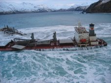
But, after suffering "significant" damage in last week's storms and sinking further into the sand, the possibility of taking the ship apart is being discussed.
A meeting early this week will decide the next steps for the salvage team who have been working on righting the ferry for more than a month.
See more information on The Riverdance
View our Shipwreck online special
See The Riverdance webcam
See our Riverdance picture gallery
It is expected the destruction of the boat would come as a bitter blow to the salvors and the Riverdance fans who have come from far and wide to see her resting on the sands just south of Cleveleys.
It was hoped that flotation tanks welded to the upward side of the ferry and the pumping of water from the starboard to the port side would help right her.
The keel would then be slipped into a huge trench which has been dug along the side of the Riverdance.
But the team has been forced into a rethink after 78mph winds battered the ship last week.
The future of the vessel today seems uncertain with a range of options being considered including dragging her upright with a series of winches and taking her apart.
Donald McDonald, the coastguard's counter pollution and salvage officer, who is overseeing the operation, said: "The way that we were intending to right the vessel cannot be achieved so we are now looking at alternative methods.
"First of all we are looking at the possibility of righting her using mechanical winches then we will look at the damage she has sustained with a view to refloating her.
"If it looks like this will be impossiblethen we will have to consider cutting her up on the beach – but we are not at that stage yet. The salvage team met for discussion on Friday and will deliver their proposed plan of action in the middle of next week."
Owners Seatruck Ferrys Ltd are keen to see the ship saved. Spokesman Tony Reddings said there were a number of possibilities yet to be explored.
He said: "She suffered significant damage during the storm but we believe there are several options still open to us. The salvors might still be able to employ part of the original plan or they might have to look at using winches or even cutting her up. No decisions have so far been made, we will have a better picture after the meeting this week."
Riverdance got into trouble during high winds and story seas on January 31 while en route from Warrenpoint in Northern Ireland to Heysham, landing on the Fylde coast on February 1.
RS








![Validate my RSS feed [Valid RSS]](valid-rss.png)
No comments:
Post a Comment