With almost one call-out a day, the crews of HMS Gannet smashed the previous UK record for a search and rescue station of 269 call-outs in a year.
The Sea King helicopters stationed at the Ayrshire base play a leading role in many Scottish mountain rescues, and are called to rescue stranded fishermen up to 200 miles out into the Atlantic Ocean.
Mr Browne said: "The staff of our search and rescue stations around Britain, whether Royal Navy, RAF or HM Coastguard, put their lives at risk on a regular basis to save others. For the men and women at HMS Gannet in 2007, this equated to a call out for almost every day of the year – an astonishing statistic.
"They are to be commended for the excellent work which they do above the land and sea of Scotland's west coast and the north of England, and I am delighted to have been able to talk to these highly skilled rescuers in person and to personally thank them for their efforts."
The commanding officer of HMS Gannet, Lieutenant-Commander Brian Nicholas, added: "These are just amazing figures. We are very proud of the service we provide.
"Our area is a huge and complex one, stretching from Coll and Ben Nevis in the north to the Lake District in the south, Northern Ireland in the west to the Trossachs in the east. I am lucky to have amazing teams of people working here, both Royal Navy and civilian.
"I suppose it's always nice to be able to hold a record, but for all of us here it's not about that – it's about responding whenever we are needed to provide emergency support. No more, no less. That's our job and it's one we all love and are wholly committed to."
Lt-Cmdr Martin Lanni, the base's second in command, said: "We are always one of the busiest – but this was a very, very busy year – a bit of a landmark.
"We don't go out there to try to break records or get any rewards. But the guys are going to extraordinary lengths day in, day out, and it's hard not to be proud of that." (Story continued)
TWISTER NEWS
Official says tornadoes, thunderstorms did $15 million damage
The Associated Press
ATLANTA --Thunderstorms and tornadoes that raced into Georgia from the west Tuesday morning caused about $15 million damage to some 1,300 homes, a state official said Wednesday.
Insurance Commissioner John Oxendine earlier estimated insured losses to 1,000 homes across north Georgia at $10 million, but after surveying the damage he said "the destruction around Carrollton and Bowdon was more extensive than first reported."
He said the damage ranged "from broken windows to total losses in some cases."
Two tornadoes touched down in Carroll County. Officials said the first, an EF3, hit the Smithfield area, just inside the Alabama state line, and left a path eight miles long and 100 yards wide with winds estimated at 140 miles per hour. The second tornado was smaller, with winds of 90 miles an hour and a swath two miles long.
Despite the destruction, the county had only three injuries - two requiring hospitalization and one minor injury, Carroll County fire-rescue Chief Gary Thomas said.
National Weather Service booklet outlines tornado cautions
In the wake of the Feb. 5 tornado, which caused massive damage and in northern Benton County and several deaths across the state, Governor Phil Bredesen has declared Feb. 24-29 as “Tennessee Severe Weather Awareness Week.”In accordance with that declaration, the National Weather Service (NWS) has issued a small booklet containing planning tips that will hopefully increase awareness and help people across the state survive future severe weather situations. According to the booklet, as we move into Spring, now is the time to prepare ourselves for the hazards and dangers associated with severe weather, since it can and does occur any time of the day and anytime during the year.
The booklet states that tornados are nature’s most violent storms. They are a violently rotating column of air extending from the base of a thunderstorm and coming in contact with the ground. Average winds are 100 mph, but have been known to exceed 300 mph. Tornados most often occur during March, April and May, can Fall is considered to be a secondary season, especially November and December. No location, time of day or time of year is immune tornado occurrences, however.
A lot of people don’t understand the difference between a tornado watch and a tornado warning. According to the booklet, a watch is when conditions are favorable for a tornado. At times like this, people should look for signs and listen to their radio, weather radio or other information outlet in case a tornado occurs.
A warning means that a tornado has been sighted or indicated on the weather radar.
The intensity of a tornado is measured by the Fujita Scale, which was developed by Dr. T. Fujita in 1971. Tornado intensity can range from an EF0 to an EF5. An EF0 (65-85 mph winds) is considered to be a weak storm and generally pushes over shallow rooted trees. Moderate damage, mobile homes turned over and roof surfaces peeled off, can occur during an EF1 (86-110 mph winds) tornado. An EF2 (111-135 mph winds) storm is considered to be strong and capable of causing considerable damage, including uprooting large trees and destroying mobile homes. EF3 (136-165 mph winds) tornados can overturn trains and take the roof and walls off of homes. Homes can be leveled and cars tossed about during an EF4 (166-200 mph winds) tornado and an EF5 tornado (winds greater than 200 mph) are capable of disintegrating homes and throwing cars.
Developing a safety plan is essential to safety during a tornado. To that end, the booklet says that participating in tornado drills can greatly increase chances of survival. Work places, schools, churches and other places that people gather are encouraged to develop a safety plan if they do not have one.
Other severe weather conditions, including thunderstorms and flooding, are covered in the booklet, which can be obtained by calling the NWS at 615 -754-4634 or by visiting their website at www.srh.noaa.gov.
2 tornadoes touch down in Oklahoma, causing some damage
by: Murray Evans, Associated Press Writer
3/3/2008 12:00 AM OKLAHOMA CITY -- A late-winter storm system brought severe weather to Oklahoma on Sunday, with at least two tornadoes touching down in rural areas.
The tornadoes were spotted in northwestern Oklahoma, in rural areas of Blaine County and Grant County. No fatalities were reported and early damage reports seemed minimal, although strong winds associated with the storms brought down power lines, causing some outages in northwestern counties.
Television footage showed a tornado in northern Blaine County that passed near the communities of Carleton and Southard. The tornado caused hay bales to roll through fields and damaged a barn.
It also downed "a couple of power lines on a county road" but didn't cause much more damage, Blaine County Sheriff's Deputy Adam Austin said.
"It was just more of a scare than anything else, really," he said.
The Oklahoma Highway Patrol reported another tornado touchdown just south of Manchester in Grant County, near the Kansas state line. The OHP said numerous power lines were down in the area and that a barn has been destroyed.
State Highway 132 was closed Sunday night north of State Highway 11 because of the downed power lines.
Latasha Jennings, a dispatcher at the Grant County Sheriff's office, said the amount of damage still was being assessed Sunday night.
National Weather Service meteorologist Chris Sohl in Norman said the official number of tornado touchdowns has yet to be determined, although he didn't doubt the veracity of the reports in Blaine and Grant counties.
He said the storm system that spawned the twisters also produced high winds and hail that caused "scattered damage" along the front. In Breckinridge, just east of Enid in Garfield County, a 70 mph wind gust was recorded.
Such a storm system "is not all that odd, but this early in March, sometimes it's a trick to get enough moisture up here for (atmospheric) instability," Sohl said.
This time of year, he said, "you start to get enough moisture in the area for storms, but you're still in the winter months and can drag in some cold air as well."
He said a cold front entering the state from the west is a primary cause of the storms. That front will drop temperatures into the 30s in most of Oklahoma on Monday, after highs reached the upper 60s to lower 80s in most of the state on Sunday.
The front also could produce snow, sleet and freezing rain, he said.
The weather service issued snow and blowing snow advisories through Monday morning for the Panhandle and through Monday evening for parts of southeast, south and central Oklahoma.
MARITIME NOTES:
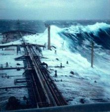
It can't be said often enough: Respect the ocean, for despite its beauty, it is merciless.
This harsh fact was on display from Santa Barbara to San Diego earlier this week as huge waves overwhelmed several beachgoers and fishermen, knocking them into the churning surf.
Most made it back to shore safely, but not all. One of the lucky ones was Joseph Mayer, a 76-year-old Ventura resident.
Sunday, Mr. Mayer was saved from possible drowning by two good Samaritans who pulled him from the chilly water after a large wave swept him off a jetty at the end of Seaward Avenue. He suffered hip and rib fractures and several cuts, but survived the ordeal.
Equally lucky were three people who also ended up in the ocean Sunday after being swamped by a wave as they walked on the Santa Barbara Harbor breakwater. The harbor patrol managed to pull them to safety.
Not so fortunate, however, was a 23-year-old fisherman who was swept into the ocean, along with two other anglers near Palos Verdes on Sunday night. Two of the fishermen made it back to dry land, but the third is still missing.
The Palos Verdes drowning is reminiscent of a Jan. 12 tragedy that saw an Oxnard teenager swept out to sea by a rogue wave. Victor Mendez Ortiz, 16, was fishing near Mugu Rock with his older brother when the wave knocked him off a small cliff and into the surf as he was attempting to untangle some fishing line. His body has never been found.
The towering waves — some reaching more than 20 feet high — that pounded the shoreline earlier this week are gone now. It's expected to be perfect beach weather this weekend.
Just be careful and keep an eye out for changing ocean conditions.
RS








![Validate my RSS feed [Valid RSS]](valid-rss.png)