ScienceDaily (Sep. 12, 2008) —
Residents along the Gulf Coast are bracing for Hurricane Ike as it travels over the Gulf of Mexico after ripping through Cuba and Haiti. ESA’s Envisat satellite is tracking the storm, which is forecast to make landfall on the Texas coast by 13 September.
Knowing the strength and path of hurricanes is critical for issuing timely warnings. Earth observation (EO) satellites are key means of providing synoptic data on the forces that power the storm, such as cloud structure, wind and wave fields, sea surface temperature and sea surface height.
Thanks to Envisat’s unique capability to acquire optical and radar imagery over the same area of the Earth simultaneously, the top and bottom of a hurricane can be viewed at the same time. The unique view of Hurricane Ike on the left is an example of combined optical and radar images, showing the swirling cloud-tops and the shape of the wind-driven sea surface.
Moreover, satellite-based radar instruments have the capability of penetrating heavy clouds and precipitations and can provide day and night high-resolution observations of critical ocean parameters, such as local wind, waves and currents over a 400-km-wide region.
Using these capabilities specific to radar satellites, Dr Bertrand Chapron of IFREMER, the French Research Institute for Exploitation of the Sea, and Dr Fabrice Collard of France's CLS radar application division in Brest, have developed sets of algorithms that allow data from the Advanced Synthetic Aperture Radar (ASAR) instrument aboard Envisat to be processed in Near-Real Time (NRT) and to produce state-of-the-art ocean parameters.
Taking advantage of the broad availability of Envisat ASAR wide swath acquisitions taken over the hurricane region, the corresponding sea surface roughness map, wind speed map and surface current are made widely available on the SOPRANO ocean products demonstration website developed with ESA.
"The knowledge of hurricane eye details, the radius of very high winds, details on the swell fields, and the new information on atmosphere feedback to ocean surface velocity will certainly help coupled ocean-atmosphere models to better predict hurricane track and intensity," Dr Chapron said.
As clearly revealed for Hurricane Ike, wind speeds around the hurricane’s eye can far exceed 40m/s (about 80 knots).
The sea surface roughness map clearly shows a minimum in the well-delineated eye where the conditions are relatively calm. Around the eye of the storm, the sea surface velocities also capture the circular direction of the prevailing wind and waves, as visible in this image over Great Inagua Island in the Bahamas on 7 September.
This analysis of the residual Doppler from the radar echoes allows for the retrieval of radial velocities which are used to provide systematically and in Near Real Time a map of the radial component of sea surface velocity.
The colour of the graphics shown in the ‘current’ section is representative of a very strong eastward motion in the southern part of the hurricane and a symmetrical strong westward motion in the northern part. These observations are clearly in line with the hurricane winds turning counter clockwise.
In the future, these combined instantaneous wind speed, wave heights and surface velocity maps will be integrated into models to improve storm track and intensity forecasts.
"Sentinel-1, the follow on to Envisat’s SAR mission, will have an improved instrument capability with dual polarisation and higher imaging resolution, and will benefit from this demonstration to achieve better winds accuracy in extreme conditions," Dr Collard said.
WEATHER NOTEMy good friend at Freaque Waves has an outstanding write on the BBC Freaque Waves progem.
BBC video on freaque waves On November 14, 2002 BBC first shown the long awaited program "Freak Wave" on BBC Two in U.K. I am not certain if it was ever shown in the U.S. But I had an opportunity of watching the video version of the program at a conference in the spring of 2003. For some reason the video was not released for wider commercial distribution. I just realized that the program is now available on YouTube in 5 parts as posted in the following. My sincere appreciation to the one that made these available:
Rest of the post
Demolition team works to clear barges from Texas 73
By RYAN MYERS
September, 21, 2008
PORT ARTHUR - The stretch of Texas 73 between Port Arthur and Winnie could open by mid-week after two barges dropped on the highway by Hurricane Ike are cut apart and removed.
"We're ripping them apart, one chunk at a time, and then we'll haul away the pieces on trucks," said Jeff Fuller with Xtreme Demolition, an Oak Island-based marine salvage company.
Ike's storm surge pushed the tethered barges almost 10 miles from near Sabine Pass, dropping them across the highway near Englin Road. At Sabine Pass, storm surge reached almost 14 feet.
The barges, each about 200 tons and 200 feet in length, were owned by a construction company and used for moving cargo up and down the Intracoastal Waterway, Fuller said. The construction company's insurer is paying for the demolition and removal.
To move the barges, Fuller's team is using a large demolition machine that looks like a tank fitted with a giant can opener.
After gripping a section of steel hull, the machine twists and pulls, slowly ripping the ships into shreds.
To preserve the highway surface, the machine first cuts a hole inside the first ship, Fuller explained, standing beside the demolition project Sunday morning.
"That way, we can cut from the inside out, with our machine actually resting on the floor of the barge, and not on the highway surface," Fuller said.
Once the barges are removed, transportation officials will inspect the highway for damage before it can be reopened, said Marc Shepherd, a spokesman with the Texas Department of Transportation.
Shepherd said he did not anticipate any significant damage.
"We got started tearing them apart this morning about 9 or 9:30," Fuller said. "I'm hoping we'll be done in two or three days at the most."
Hurricanes, Hanna and Haiti: What Natural Disasters Illustrate
The storm brought massive destruction. Flooding was considerable.... Houses collapsed on themselves. The roofs of those that did not became the last refuge for desperate men, women and children. With no food or water, they prayed for help, but it did not arrive.
Katrina is still burned in my psyche as one of the most catastrophic events in recent memory. The harsh divides of class and race and their connection to access were clear. Yet, what I just described is the scene unfolding in Haiti in the aftermath of Hurricane Gustav and Hanna.
The death toll in Haiti to date well exceeds 100, with thousands displaced and stranded, and President René Préval has called the crisis a "catastrophe." Aid agencies cannot reach the most desperate.
Due to the fierceness of the storm and soil erosion, "lakes" have formed all over the rural areas, making roads impassable for aid trucks. Eyewitness reports state the aftermath is worse than Hurricane Jeanne of 2004.
Reports of the impact of natural disasters on world's most neglected communities always read a bit ironic to me.
Haiti's failing infrastructure is a well-known certainty. For more than 25 years the US and the World Bank gave millions of dollars to dictators for infrastructure creation. Urban roads continued to crumble.
Rural roads remained unpaved. Yet in recent years, the world has withheld money from the democratically elected government to accomplish the same goal. Repeatedly, the Haitian government, community groups and human rights advocates stated that the any major storm would be catastrophic given years of neglect and de-funding coupled with soil erosion caused by deforestation.
Slow to act, the U.S. government has promised a mere $100,000.00 for relief from these hurricanes. While I hope that they will provide more emergency relief dollars and the planning and transport to reach the neediness, once again the long-term impacts of the neglect of Haiti is not acknowledged.
Damage to Haiti's already inadequate food crops will only serve to further amplify the food crisis affecting millions across Haiti. Because roads remained unpaved, the water creates impassable mud lakes. Standing water will only serve to spread water borne infectious diseases. Unlike with Katrina, the displaced have nowhere to go. The U.S. government's policy to return fleeing Haitians to Haiti with little to no due process remains unchanged throughout these disasters.
The paradox of Gustav's appearance on our Gulf Shores was not lost among those fleeing three years ago from Katrina. Yet the entire Diaspora is vulnerable to nature's wrath and humanity's neglect. While Gustav spared the Gulf Coast of the horrors we have experienced and can imagine, more storms are on the way. While many are skeptical of the infrastructure in place in the U.S. for such storms, we know that in countries like Haiti no such systems exist.
No doubt that each day that passes without assistance Haitians and other Caribbean people will suffer alone wondering if anyone will eventually come to help them. Many of them will not survive.
As we invest in our early warning systems and programs, the US also must make investments in the infrastructures of our closest neighbors. Paving roads, planting trees, and sustainable economic development would have a significant impact on the impact of hurricanes in Haiti.
When we see fellow Americans suffering and desperate, it is difficult to turn away and yet we turn away from the suffering of our people only a couple hundred miles away from our shore.
Katrina and Rita illustrated that we can all be vulnerable to need and injustice. In the aftermath of Gustav, Hanna, and now with Ike and Josephine on the way, can Americans address the issues highlighted by natural disasters and demand action?
Nicole C. Lee is the Executive Director of TransAfrica Forum.
GUSTAV and IKE PIX's
Stormer Chaser Steve Miller (TEXAS TAILCHASER'S STORMPAGE!) has just updated his site with pix's of Hurricanes Gustav and Ike. Take a look...Ike Here and Gustav here.....
Warnings as super storm rolls across NSW (AUSTRALIA)
HUGE storm heading for the New South Wales eastern seaboard, including Sydney, has cut a path of destruction in western NSW with winds over 100km/h tearing roofs off buildings and felling trees.
Emergency crews across NSW are on high alert as the severe thunderstorm from the northwest engulfs most of NSW and moves towards the NSW coast.
The Bureau of Meteorology at 7pm (AEST) said: "Thunderstorms are likely to produce large hailstones and damaging winds over the next several hours.
"Locations which may be affected nclude Port Macquarie, Armidale, Tamworth, Moree, Narrabri and Mungindi.
"A severe weather warning for damaging wind remains current for Sydney Metropolitan and Hunter Districts, Upper Western, Southern and Central Tablelands, ACT, South and Central West Slopes and Plains, South Coast and Illawarra, however, conditions are expected to ease through the night."
Wind gusts of 115km/h were recorded today at Fowlers Gap, near Broken Hill, and wind speeds are surpassing 60km/h in western Sydney, a Bureau of Meteorology (BOM) spokesman said.
"It's not one small cell, it's a great large area of strong winds and thunderstorms,'' BOM duty forecaster Peter Zmijewski said earlier today.
"Winds in Sydney have already picked-up in the west.''
NSW Maritime has issued a gale-force wind warning with a forecast of 4m swells off the coast of Sydney and Hunter regions.
NSW Emergency Services Minister Tony Kelly said residents should not underestimate the conditions heading for metropolitan and regional areas.
"This is an unfortunate but timely warning that now is the time for residents and businesses to be prepared."
The State Emergency Service (SES) has had 90 calls for assistance across far-west NSW.
Strong winds and some rain caused a large tree to fall and crush a car at Broken Hill, SES spokesman Phil Campbell said.
Further south at Hay the damage was more severe.
"There, we've had winds gusting up to 104km/h that have totally unroofed one property and have brought down the verandah at the Terminus Hotel,'' Mr Campbell said.
The SES is bracing for much greater damage once the brunt of the storm reaches the coast.
"The biggest risk will come this evening as we do have more populated areas such as the eastern seaboard impacted by these severe weather warnings and destructive winds,'' Mr Campbell said.
He said rain has been less of a factor in the state's west but could be disastrous later on.
"Generally when the rain is falling, it's only very quick according to our volunteers out in the field,'' he said.
"But there is heavier rain due in tonight and if properties get some damage due to wind, rain will exacerbate that damage.''
The SES recommends people secure loose items around houses and properties, keep clear of fallen power lines and unplug computers and appliances.
People should also stay away from windows and keep children and pets indoors.
NSW Maritime is urging boat owners to check their moorings and exercise caution while on the water.MARITIME NOTES
New study highlights present and future maritime traffic flows in the Mediterranean
The Mediterranean Sea is amongst the world’s busiest waterways accounting for 15 per cent of global shipping activity by number of calls and 10 per cent by vessel deadweight tonnes (DWT), says new study. Overall vessel activity within the Mediterranean has been rising steadily over the past 10 years and is projected to increase by a further 18 per cent over the next 10 years.
Transits through the Mediterranean are expected to rise by 23 per cent. Increases in vessel activity will be coupled with the deployment of ever larger vessels. Chemical tanker and container vessels will show the highest rates of growth in respect of port callings within the Mediterranean over the next ten years whilst increases in transits will be most pronounced in the product and crude tanker sector.
The full report can be accessed here: REPORT
Liz McCarthy - Thursday 18 September 2008
SALVAGE operations for the remaining stern section of the MSC Napoli have been suspended until next year in an effort to cut costs, writes Liz McCarthy.
The decision has been agreed by the ship’s insurers and the Environment Group due to the onset of autumnal storms, in a pragmatic approach to save money.
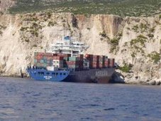
The MSC Napoli was beached in Devon after taking on water in the English Channel in January last year.
The remaining section of the ship is heavily constructed, and, according to the Secretary of State’s Representative Hugh Shaw, is proving difficult to dismantle.
The engine weighs approximately 1,400 tonnes and an estimated 3,000 tonnes of silt and clay has become trapped inside the ship, adding substantial weight to the structure.
A large cutter that the MCA has been looking to obtain is not available until late October, when the weather is due to become unsuitable.
With many specialist divers on site, long delays caused by bad weather could have cost the insurers a significant amount of money. Other specialist equipment is also needed, but is not due to be available until the spring.
Exact details of when salvage operations will commence are not yet known, but it is thought that the insurers and salvors will have changed the salvage contract accordingly by today.
MARITIME ALERT! MARITIME ALERT! MARITIME ALERT!
USCG – Safety Alert – counterfeit EEBDs
The US Coast Guard issued a Safety Alert stating that counterfeit Unitor model UNISCAPE 15h emergency escape breathing devices (EEBDs) are being sold to ship operators and placed onboard commercial vessels. As explained in the Safety Alert, there are physical differences between the authentic and the counterfeit devices. If in doubt regarding your EEBD, contact the manufacturer. (9/19/08).
On a boat in the middle of Hurricane IkeHere is another one...
RS



![Validate my RSS feed [Valid RSS]](valid-rss.png)