Showing posts with label cost of storms. Show all posts

Monday, January 26, 2009

Chasing 'Thundersnow' Could Lead To More Accurate Forecasts

Chasing 'Thundersnow' Could Lead To More Accurate Forecasts

ScienceDaily (Jan. 15, 2009) — The job of one University of Missouri researcher could chill to the bone, but his research could make weather predicting more accurate.

Patrick Market, associate professor of atmospheric science in the College of Agriculture, Food and Natural Resources, is chasing storms in the dead of winter in order to release weather balloons that will produce data about the little-known phenomenon of thundersnow.

"One of the things we don't understand is how the cloud becomes electrified," Market said. "We hope to determine how the atmosphere is becoming unstable."

Market and his storm-chasing students are searching for winter storms in order to release weather balloons into the storm every 90 minutes over a 24-hour period. The balloons carry boxes with a barometer to measure pressure, a thermometer to measure temperature, and a hydrometer to measure humidity.

Market uses a GPS to monitor wind speed and direction of the balloons. This information covers the five things that are most important for a meteorologist to know for accurate predictions, according to Market.

"It has been decades since a detailed study with modern weather balloons has been done to see how the atmosphere destabilizes for summer thunderstorms, much less the winter storms," Market said. "So we are taking this tried-and-true tool of the meteorology trade and applying it to the very specific instance of heavy snowfall in the winter."

Once the weather balloons are launched, they provide detailed readings of every layer of the atmosphere. More detailed readings and data provide better and more accurate forecasting."We get thunderstorms in all seasons. That means something is making the atmosphere unstable," Market said. "Thunderstorms are often associated with heavy rainfall or heavy snowfall. It's just as important to get it right in the spring, summer or winter."

The phenomenon known as thundersnow is not understood very well. It is defined as a snowstorm with thunder and lightning that can bring heavy snowfalls of 8 to 12 inches. Tracking such storms can be quite a challenge.

"Often, these winter storms cause us to travel through inclement weather in order to get to the area where the weather balloons should be launched," Market said. "During travel, the heater in the vehicle cannot be on because the instruments need to be kept cold."

WEATHER NOTE

Record Shows Disasters Kill Most

Freetown — Acting director of disaster management department in the office of national security (ONS) has said in Freetown that disasters amount to greater percentage of the causes of death of the world's population.

John V. Rogers told participants at the opening ceremony of the training of trainers' clinic on disaster risk reduction for schools that though they cannot stop disasters from happening yet they can with their knowledge on disaster risk reduction and early warning signals.

"Man's negative interaction with his environment has often produced harmful effects with devastating consequences on human existence," he said.

Rogers said this sad chapter can only be reversed through learning and implementation of best practices as demonstrated in other areas of the world.

"Some of the disaster related incidences in Sierra Leone are due to illiteracy and ignorance. It has often been stated that a well informed public is a protected one," he said.

He said it has been the ardent desire of government to enhance the capacity of teachers that have played tremendous role in the disaster management school outreach programmes in the country.

The acting director noted that children were among the most vulnerable population group during a disaster especially those attending school at the time of the crisis. "Therefore learning about disaster risk reduction in schools can put teachers and children in a better position to play important role in saving lives and protecting members of the community in time of disaster."

He added that the clinic would provide the necessary tools to teachers and students in educational institutions to prepared, mitigate and respond to disasters.

On behalf of the national security coordinator, ONS chief of staff Larry Bassie said increase number of gravity of disaster with grave consequences that undermines the survival and dignity of livelihood in communities was a concern.


MARITIME NOTE

New EPIRB processing practices to reduce false distress alerts
Coast Guard says response to actual emergencies to improve

The following is the text of a feature story submitted by the U.S. Coast Guard:

Story by Petty Officer 3rd Class Melissa Hauck(ALAMEDA, Calif.) -- The Coast Guard and other emergency personnel who respond to distress calls will soon see an improvement in their ability to locate people during search and rescue cases.

This improvement centers around an emergency position indicating radio beacon (EPIRB), a device that when activated can act as a virtual lifeline from people in distress to rescue crews by sending out a transmitted signal via air, sea or land.On Feb.1, 2009 Cospas-Sarsat, an international satellite-based search and rescue (SAR) system established by the U.S., Canada, Russia and France will cease satellite processing of 121.5/243 MHz analog EPIRBs and will begin processing only the 406 MHz digital radio beacon signals, making it illegal to use the obsolete 121.5/243 MHz beacons.

The newest 406 MHz beacons incorporate global positioning system (GPS) receivers that transmit highly accurate positions of distress almost instantly to SAR agencies via the Geostationary Earth Orbit Local User Terminals (GEOSAR) satellites.

The digital frequency has been designated internationally for use only for distress. Other communications and interference, such as on 121.5 MHz analog signals, is not allowed.The change is expected to result in a substantial reduction in wasted SAR resources on false alerts while simultaneously increasing the responsiveness of the system for real distress cases."

The 121.5 MHz analog beacons produce a high incidence of false alarms and a host of other limitations that include poor signal strength, search areas that can be as large as 12 to 15 miles in radius and unreliability," said Petty Officer 2nd Class Craig Mercier, an operations specialist stationed at the District 11 command center on Coast Guard Island here."

The distress signals from the 406 MHz beacon are much more accurate than the analog beacon. Each digital beacon has a unique ID encoded within its signal that can quickly confirm that the distress is real, who they are looking for and where they should look, which will ultimately save lives," he said.When a 406 MHz signal is received, SAR authorities can retrieve information from law-required registration data that includes beacon owner contact information, emergency contact information and identifying characteristics of the vessel."

Digital EPIRBS also provide position accuracy that narrows the vessel's position to less than two miles in radius and decreases the amount of time SAR teams must search. This results in quicker response times, and is a major advantage over the 121.5 MHz beacons," he said.

The decision to stop satellite processing of 121.5 / 243 MHz signals was announced by Cospas-Sarsat nearly two years ago stating problems in the frequency band which overwhelm search and rescue authorities with poor accuracy and numerous false alerts, negatively impacting the effectiveness of lifesaving services.

The Coast Guard strongly recommends mariners obtain the new 406 MHz EBIRB and file a float plan with a friend or family member on land, with an approximate time of return and location prior to getting underway.

A float plan template can be found at http://www.floatplancentral.org/.

EPIRB owners can register their equipment in the U.S. 406 MHz Beacon Registration Database at:http://www.beaconregistration.noaa.gov/ or by calling 1-888-212-SAVE.

Beacon registration is required to be updated with accurate information every two years or when emergency contact or other information changes.

For more information on EPIRBS and the Cospas-Sarsat program visit http://www.sarsat.noaa.gov/.

Enjoy this Rollercoaster!


RS

Wednesday, January 7, 2009

NOAA models tsunami warning system

NOAA models tsunami warning system

High-resolution computer models of Oregon’s coastline that simulate tsunamis and floods have been developed by scientists at the National Oceanic and Atmospheric Administration, the agency announced Dec. 10.

Emergency managers will use the models to create evacuation and rescue plans for potential incidents, agency officials said, adding that the digital elevation models were developed by NOAA’s National Geophysical Data Center and the Cooperative Institute for Research in Environmental Science.

The models cover the Oregon coastal area from Port Orford to the Columbia River.


The digital elevation models provide a framework that allows scientists to forecast the magnitude and extent of coastal flooding caused by a tsunami or storm surge with greater accuracy than older models, NOAA said. Since 2006, scientists have created 28 digital elevation models of U.S. coastal areas and an additional 45 digital elevation models are planned for the future.

The coastal digital elevation models are part of the U.S. Tsunami Forecast and Warning System and the new Oregon models will assist the Oregon Department of Geology and Mineral Industry map tsunami evacuation zones, the agency said.

NOAA’s Pacific Marine Environmental Laboratory in Seattle incorporated the models into distant tsunami model scenarios, the agency said, adding that the scenarios simulate offshore earthquakes, the resulting tsunami that travels across the Pacific Ocean, and the potential floods when the tsunami reaches the coast.

With that information, NOAA's Tsunami Warning Centers can issue more accurate flooding forecasts if an earthquake triggers an actual tsunami, agency officials said.

WEATHER NOTE

Insurers' natural disaster losses rise in 2008
Overall losses from Gustav and Ike were about twice the insured losses.


By Geir MoulsonASSOCIATED PRESS
Tuesday, December 30, 2008

Insurers' losses from natural disasters rose by about 50 percent in 2008, with Caribbean hurricanes Ike and Gustav powering the increase and climate change increasingly becoming a factor, a leading reinsurer said Monday.

Munich Re AG said in an annual review that insured losses came in at $45 billion this year, up from nearly $30 billion in 2007. It said total economic losses, including losses not covered by insurance, leapt to $200 billion from last year's $82 billion.

That increase was due in part to the devastating earthquake that hit China's Sichuan province in May. Munich Re said the quake caused overall losses of $85 billion — by far the year's biggest — but insured losses of only $300 million.

Munich Re said the year was marked by high losses from weather-related natural disasters, continuing a long-term trend.

"Climate change has already started and is very probably contributing to increasingly frequent weather extremes and ensuing natural catastrophes," board member Torsten Jeworrek said in a statement.

"These, in turn, generate greater and greater losses because the concentration of values in exposed areas, like regions on the coast, is also increasing further throughout the world." The company noted that six named storms — Dolly, Edouard, Fay, Gustav, Hanna and Ike — reached the U.S. coast this year after two years in which the American mainland was largely spared.

The year's most expensive event for insurers was Hurricane Ike, which hit the Caribbean and the southern United States in September, causing insured losses of $15 billion. In second place was Gustav, which hit shortly before and caused losses of $5 billion.

In both cases, the overall losses were about twice the insured losses.

Munich Re said an unusually severe snow- and ice-laden cold spell in China in January and February, which hit roads, railways and electricity supplies, cost insurers $1.6 billion. That's well short of the overall economic losses, which it estimated at $21.1 billion.

A winter storm that hit central Europe in early March cost insurers some $1.5 billion. Munich Re said an unusually severe U.S. tornado season, with a total of 1,700 tornadoes, also proved costly. A series of tornadoes that killed 12 people in late May generated insured losses of more than $1.3 billion.

The year's deadliest disaster was Cyclone Nargis, which devastated coastal areas in Myanmar in early May, killing nearly 85,000 people. Munich Re put overall economic losses at $4 billion but gave no figure for insured losses in the isolated country.

Though they rose sharply for the second consecutive year, this year's insured losses were still well short of the $99 billion Munich Re recorded in 2005, when losses were swollen by claims from Hurricane Katrina in New Orleans.

The company said that year also saw a record overall economic loss of some $232 billion, adjusted for inflation.

As a reinsurer, Munich Re offers backup policies to companies that write primary insurance policies.

Reinsurance helps spread risk so that the system can handle large losses from natural disasters.

Top News of the Day from NWS Chicago!

Top 10 Weather Events for 2008 for Northern Illinois and Northwest Indiana (pdf)
End of Year Climate Summaries for Chicago OHare and Rockford (pdf)
Headed to Washington DC for the Presidential Inaugural? Click Here for Weather Information


MARITIME NOTE

Can other vessels see you on radar?

http://images.aad.gov.au/img.py/20ae.jpg

It is important that skippers of radar-equipped vessels know the capability of their own radar to detect other vessels in order to avoid collisions. However, it is critical for skippers of all vessels to know if radar on another vessel can detect their own vessel. This is especially important as weather deteriorates and visibility decreases. The range at which a vessel can be detected by radar depends on many variables, such as the radar power, antenna, the vessel’s radar cross section (how strongly it reflects radar), and the environmental conditions (weather, waves, rain, fog, etc.) Nominal detection range in ideal conditions

Keeping a sharp eye on the radar for other vessels is key, but making sure your boat can be seen by the radars of other vessels is important too. (Beau Rogers) Marine radar encompasses small recreational systems transmitting at between 2 kW and 4 kW, to professional systems transmitting between 12 kW and 50 kW. Radar cross section (RCS), expressed in square meters (m2), measures how strongly a target reflects radar pulses. Radar detects larger RCS targets with less power, at longer range, and in more severe weather conditions.

Targets addressed in this article range from one square meter RCS (1 m2) for a person or small inflatable to about 10 m2 for a large recreational vessel, with 5 m2 being representative of pleasure boats. The accompanying table summarizes maximum detection ranges in clear weather for typical marine radars and targets. While detection may occur at greater ranges than shown in certain circumstances, most of the time environmental conditions and weather limit detection to shorter ranges. The table indicates that low-power radar on a pleasure vessel will usually not detect another pleasure craft at much more than one mile, whereas a commercial ship will not detect a pleasure boat at more than four to five miles, in good weather.

Large, ocean-going ships with powerful scanners might double this. If these detection ranges seem short, remember that recreational vessels are small, both physically and as reflectors of radar pulses. For example, the radar cross section of a Navy cruiser, which is not an especially large ship, is about 160,000 m2. It is huge compared with the typical 5 m2 pleasure boat.

Other things being equal, radar that detects a cruiser at 10 miles will not detect a pleasure sailboat at more than one mile. The table also shows the difference between the typical 48-mile recreational radar (4 kW) and the typical 16 or 24-mile radar (2 kW). The greater maximum range is useful only for detecting high cliffs when far out at sea, or storm clouds at altitude, as anything on the surface beyond 16 miles would be well below the radar horizon and undetectable. The main difference is that greater power usually comes with a better antenna and more sensitive electronics, resulting in a three-fold improvement in detection range (everything else being the same).

Flat seas decrease range Detecting a vessel in perfectly calm water is more difficult than detecting it in moderately rough seas. Although this is counter-intuitive, detection in a seaway is complicated because every pulse transmitted by the scanner goes to the target over two paths. One path is direct from the antenna to the target; the other path includes reflection from the water. The two pulses combine at the target with the result that power delivered to the target may be quite different from what would be the case in the absence of reflection from the water.

One effect of this multipath pulse cancellation is to reduce maximum detection range for targets on the surface of the water. Since most of the radar-reflecting elements of a small boat are in the hull, close to the water, maximum detection range for a pleasure vessel in smooth water is much shorter than given in the table; roughly a third. Multipath pulse cancellation decreases as the seas build and the ranges shown in the table become more accurate as seas reach about seven feet. The thing to remember is that flat-sea maximum detection ranges are much shorter than shown in the table. Fog attenuates radar

Rain, fog and sea state all affect your ability to see other vessels. In poor conditions, detection range can be significantly reduced. (Beau Rogers) Fog attenuates the radar signal and reduces detection range. How much the fog reduces detection range depends on the visibility distance, scanner power, and the extent of fog between scanner and target. Here we assume that fog extends over the entire distance between scanner and target vessel. When the maximum detection range in clear weather is short to begin with, for example, the target vessel is small, or the radar on the other vessel is a low-power recreational system, percentage reduction in detection range does not mean much in absolute terms.


For example, fog with six-meter visibility reduces detection range of two miles in clear weather to 1.5 miles, an absolute reduction of half a mile. On the other hand, when the maximum detection range in clear weather is long, for example, the target vessel’s RCS is large, or the radar on the other vessel is a high-power professional system, percentage reduction in detection range is far more significant. Fog with six-meter visibility reduces 10-mile detection range in clear weather to less than four miles, a six-mile reduction. Sea-clutter limits detection Waves produce target-masking clutter. Since waves cover a large area of the sea, they produce numerous blips covering a large area of the display.

These mask returns from useful targets like your vessel by filling up, or cluttering the display with blips due to waves. While the radar operator can adjust controls to minimize the visual cluttering effect, reliable target detection is possible only if the target produces a stronger return than the nearby waves. The operator simply decreases the gain until the clutter disappears, leaving blips representing desired targets. Of course, this works only if the target is stronger than the clutter.

That is, the target must stand out against the background clutter. Scanner power is irrelevant, since increasing power simply increases both clutter return and target return the same amount. Waves reflect radar pulses when the wave face is perpendicular to the radar beam. The distance from the scanner at which the waves are perpendicular to the radar beam is proportional to wave height and to the height of the scanner.

The strength of the reflection, i.e. the effective RCS of the sea surface, depends on the wave height and distance from the scanner. It peaks at a certain sea-clutter limit distance, which depends on the antenna height and sea state. The radar return from more distant waves becomes insignificantly small. At shorter distance, the radar return from waves remains roughly constant. Usually the wave clutter appears in the direction from which the waves approach, generally to windward. Five-foot waves produce a sea-clutter limit of about a half mile around a scanner 10 feet above the waterline. Doubling the wave height or doubling the antenna height each doubles the clutter limit. The same five-foot waves that produce a half-mile clutter limit around a pleasure powerboat might produce a two-mile clutter limit around a small ship with scanner 30 feet above the water, and out to six miles for a very large ship.

Skippers of radar-equipped pleasure boats used to seeing a small area of sea-clutter on their radar display must understand that a large ship experiences a much larger clutter limit due to the scanner height. Summarizing the effect of sea-clutter on detection range is difficult because of the dependence on antenna height and wave height. Generally, the larger radar systems are generally on larger ships and are higher, so the clutter ring is larger. Consequently, you will disappear into the clutter at greater range from a large ship than from a recreational vessel. You should remember that detection of your vessel outside the sea-clutter limit ring is determined by signal power (i.e. RCS, transmitter power, distance, and attenuation from fog and rain). Sea-clutter limits detection inside the clutter ring.

Waves can cause shadows Since most of the reflecting material in a pleasure boat is in the hull, waves larger than a vessel’s freeboard can shadow the vessel whenever it is in the trough between waves. The vessel can be detected only when it is on the crest of a wave; it will be masked and undetectable when in a trough. The resulting intermittent detection makes it difficult for a human radar operator to see the vessel’s radar blip and virtually impossible for automated systems like ARPA to detect and track it. Rain attenuates radar pulses Rain and other precipitation such as snow and sleet reduce detection range in two ways.

First, rain attenuates the radar pulses just as fog does. The difference being that the amount of rain is described as rainfall rate in millimeters per hour (mm/h), rather than as visibility range. Second, rain produces clutter return similar to wave clutter. When rain surrounds the target, clutter is invariably the dominant factor rather than attenuation. Since the clutter return is proportional to the amount of rain (and the rainfall rate) in the volume of space covered by the beam, and the beam fans out with range, there is always a rain-clutter-limited-detection-range that depends only on the rainfall rate and target RCS. Beyond this limit, you will not be detected. Closer than this limit, you may be detected if range and attenuation don’t prohibit it. The key concept is that detection is possible only at ranges shorter than the rain-clutter limited detection range, which depends only on the rate of rainfall.

The classic radar reflector for smaller yachts is the corner reflector mounted in the “catch rain” orientation in the rigging often from a spreader. (John Snyder) Consider a large recreational vessel target and a small professional 12 kW radar. In clear weather, the target may be detected at five and a half miles. If rain surrounds the target, detection range is clutter-limited to slightly less than three and a half miles by drizzle and to slightly more than one mile by light rain. Moderate or heavier rain limits detection to less than half a mile. Rain surrounding the vessel severely restricts detection. Even light rain will limit detection in most cases to little more than a mile. A high-power professional radar will do better, because the beam width is narrow and it is less affected by rain-clutter.

You should remember that detection of your vessel inside the rain-clutter limit ring is determined by signal power (i.e. RCS, transmitter power, distance, and attenuation from fog and rain). Rain-clutter limits detection outside the clutter ring. Pleasure vessels are not strong radar targets, multipath pulse cancellation limits detection range in calm sea conditions, shadowing limits detection when the waves are larger than the freeboard, and the radar horizon is limited because the target is on the surface. Fog and rain attenuate the signal and reduce the probability that a pleasure vessel is detected.

Clutter from waves and rain may make detection impossible regardless of the scanner power. As skipper of a pleasure vessel in good weather and calm seas, you may think in terms of being detected by low-power recreational radar at half a mile or so and by professional radar on a large ship at four miles or so. Detection range improves about three to one as the seas build to seven feet or if a good radar reflector is mounted on the vessel. Other than that, darkness, light drizzle, moderate fog, and waves up to three feet have little effect on detection range.

This reflector on the stern will provide some reflectivity, but won’t greatly increase radar visibility. (John Snyder) Detection in bad weather is problematic. Thick fog and drizzle extending over large areas may attenuate the radar signal greatly and reduce detection range severely. If the rain surrounds your vessel, clutter restricts detection to ranges shorter than the rain clutter limit range, which is about one mile in light rain, half a mile in moderate rain, and even shorter in heavier rain.

This is independent of the radar. Detection range may be better if your vessel is large, or if you have a good radar reflector, but the skipper of a recreational vessel should not count on being detected at more than half a mile in moderate rain. Waves generate a clutter limit. Outside the clutter limit, wave clutter has little effect on detection. Inside, detection is possible only if the target is larger than the wave clutter. Three-foot waves are not much of a problem. Five-foot waves require a moderately large radar reflector; eight-foot waves require about 10 m2; 10-foot waves probably preclude detection entirely. The sea-clutter limit is proportional to antenna height and sea state; the larger ships, i.e. higher antennas, experience the larger clutter rings, up to several miles. Detection range may be better if your vessel is large or if you have a good radar reflector, but the skipper of a recreational vessel should not count on being detected at less than a mile in eight-foot waves. It does not take much in the way of rain or waves to limit detection of a pleasure boat to a mile or less.

A vessel approaching at 20 knots would have no more than three minutes to detect you, identify you, track you and determine risk of collision, and decide on a course of action. A large vessel wouldn’t be able to avoid you under these constraints.

Your best option is to proceed with caution in bad weather.

RS

Friday, November 7, 2008

Hurricanes Gustav and Ike Continue to Impact the Energy Infrastructure

Hurricanes Gustav and Ike Continue to Impact the Energy Infrastructure

Two months ago Hurricanes Gustav and Ike pounded the US Gulf Coast causing significant disruption to the nation’s energy infrastructure in Louisiana and Texas. Segments of our energy infrastructure impacted include:

  • drilling and exploration rigs
  • petroleum and natural gas production platforms
  • offshore-to-onshore petroleum and natural gas pipelines
  • natural gas processing stations
  • onshore petroleum and natural gas pipelines
  • petroleum refining system
  • petroleum product pipelines
  • electricity transmission system
  • electricity generation

Much has been learned about restoration from the Rita and Katrina experience of 2005. Folks working in the energy sector have performed heroically towards restoring a very complex energy system to meet demand from consumers, industry and government.

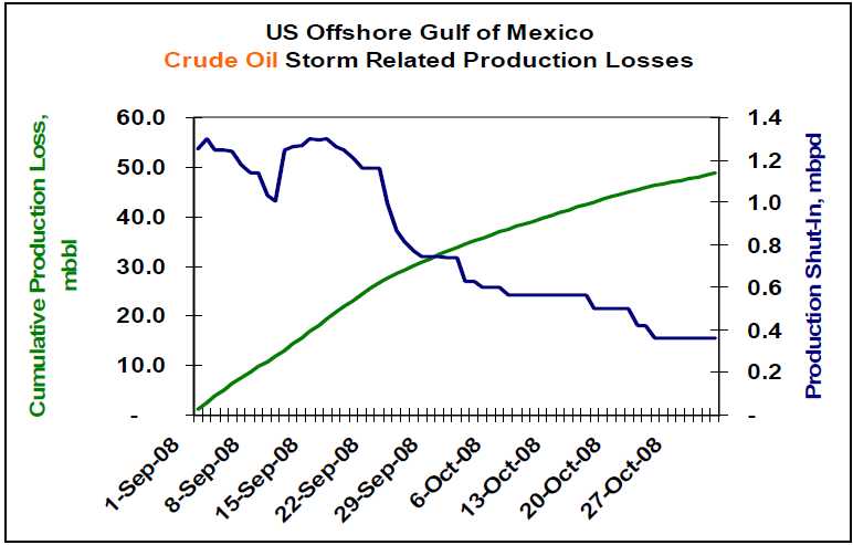
So how is the restoration effort progressing? Capstone Trading Advisors is tracking the cumulative US Offshore Gulf of Mexico production losses as reported by the US Minerals Management Service. As of 30Oct08, approximately 359.7 mbbl/day of crude oil and 2.4 Bcf/day of natural gas production continues shut-in. That equates to 27% and 33% of pre-storm production capacity, respectively. Within the last two months, cumulative production losses total 48.7 million bbls of crude oil and 253 Bcf of natural gas. See the charts below.

Lower petroleum product demand, and a corresponding reduction in refinery utilization, has cushioned the impact of this lost production. The key petroleum price drivers on a go-forward basis include 1) the depth of the global recession, 2) OPEC’s production response to lower crude oil prices, and 3) geopolitical events.

The deficit in US offshore GOM natural gas production has been made up via production from unconventional onshore sources including shale, coal bed methane and tight low-permeability formations. It is estimated that roughly 4.2 Bcf/day is being produced from these unconventional sources.

The US is expected to end the natural gas storage fill season at approximately 3.45 Tcf. The combination of storage and increased production from unconventional sources should be adequate for a normal winter season. A harsh, or early, winter could lead to significantly higher natural gas prices during the winter months. Weather is the wildcard for the natural gas market.

WEATHER NOTE

National Weather Service festival will unveil Oklahoma City Microne

NORMAN — A network of 40 weather-observing stations in Oklahoma City will be unveiled Saturday during the annual National Weather Festival in Norman.

The free festival, scheduled 9 a.m. to 1 p.m. at the National Weather Center on the University of Oklahoma research campus, also will feature hourly weather balloon launches, a storm chaser car show, a children’s activity area and a weather center open house.

The Oklahoma City Micronet dedication is scheduled for 10:15 a.m. The Micronet will have four Oklahoma Mesonet stations, along with 36 miniature weather stations installed on traffic signals throughout the city.

The Oklahoma Climatological Survey developed the Micronet in cooperation with OU and the city of Oklahoma City. The survey also runs the Mesonet, the system of more than 110 weather stations throughout the state.

Mesonet and Micronet stations record temperatures, wind speed and precipitation.

Past National Weather Festivals have attracted visitors from all over Oklahoma and other states.

The car show features vehicles ranging from weathered clunkers driven by amateur chasers to newer television-station vehicles with state-of-the-art technology.

Visitors also can see forecasters at work while touring the National Weather Center, said Keli Tarp, a spokeswoman for the National Oceanic and Atmospheric Administration’s Weather Partners.

Nearly Half of U.S. States Fail on Emergency Plan Communication, New Study Shows

ScienceDaily (Oct. 27, 2008)
Seven years after Sept. 11, and in the wake of many major natural disasters such as forest fires, hurricanes and flooding, nearly half of U.S. states either have no state-level emergency plan or do not provide it readily to the public, reveals a new study by George Mason University Communication Professor Carl Botan.

Despite federal laws that require a state emergency operations plan (EOP) as a prerequisite to some federal funding, 22 states were unable to provide Botan with an EOP, withheld the plan on security grounds or made it difficult for even trained researchers to gain access. Residents of these states, Botan says, may question their state's preparedness because they are unable to find out how the highest authorities in their state coordinate responses to major disasters or how to have a say in those plans.

"While most Americans will have access to some important state-level information during emergencies, many may not. When minutes may make the difference between life and death in an emergency situation, the population should not have to waste precious time looking for answers or who to turn to," says Botan.

The study, "Using Sense-Making and Co-orientation to Rank Strategic Public Communication in State Emergency Operations Plans," graded and ranked the state emergency operations plans of the 50 U.S. states and the District of Columbia on their communication components.

Botan analyzed the accessible state EOPs for three criteria: if the plans had a two-way communication component, if they addressed the communication needs of vulnerable populations and if they treated public communication as important enough to specifically address it in the plan.

He found that the 29 jurisdictions that do have plans available make provisions for public communication-including news releases and public broadcasts, but only 16 of them make explicit or implicit provisions for two-way public communication such as community forums and focus groups. Botan feels that two-way public communication is essential in the plans, for that will allow the state to understand what its residents feel they need in emergency situations.

Of the 29 plans obtained, only two-Washington, D.C. [which is treated as a state-level entity for this purpose] and New Mexico-received a perfect score of eight for communication.

In addition, while 16 states mentioned vulnerable publics, only 13 of these discussed specific communication strategies for these vulnerable publics in their plans. For example, California mentions specific strategies such as dispatching special teams targeting vulnerable populations like the aged and the disabled, while Arizona simply mentions that emergency managers must pay attention to "special needs" people like residents of nursing homes and the hearing impaired, but does not outline specific strategies to communicate with them.

As of 1988, all states are required under the Stafford Disaster Relief and Emergency Assistance Act to have a written EOP in order to qualify for some federal funding. "Billions of tax dollars have been spent on homeland security in the last half-decade," Botan says. "It's very important that these plans are available to the public. Otherwise residents can't be confident their needs have been thought of, and aren't sure who they can count on."

The study, co-authored by George Mason University alumni Paul Penchalapadu, is to be presented at the National Communication Association annual conference in San Diego on Saturday, Nov. 22.


MARITIME NOTE

Coast Guard rescue swimmer injured during sinking sailboat rescue

PORTSMOUTH, Va. - Coast Guard rescue crews from six different units, including three Cutters and three Air Stations, responded to a sinking sailboat with three people onboard approximately 102 miles southeast of Atlantic City N.J., Wednesday.

Rescued were Kevin Hogan, a 52-year-old and Teresa Gravie, age unknown. Phil Rubright, a 65-year-old Detroit resident was recovered but pronounced deceased by the Atlantic County Medical Examiner Office in Atlantic City.

The Coast Guard began its search after watch standers at the Rescue Coordination Center in Portsmouth received an Emergency Position Indicating Radio Beacon (EPIRB) alert and determined it was aboard the 44-foot sailing vessel FREEFALL.

After obtaining this information Coast Guard rescue crews, aboard a C-130J and MH-60 Jayhawk helicopter were launched from Coast Guard Air Station Elizabeth City, N.C.

The Elizabeth City rescue crews arrived on scene but were unable to hoist the three passengers from the FREEFALL due to the extreme weather conditions consisting of rain and 40-50 knot winds and 40-50 foot seas. The rescue crew determined that in order to conduct a safe hoist the passengers and the rescue swimmer had to enter the water. The rescue swimmer and Mr. Rubright entered the water to attempt the hoist but the rescue basket and hoist cable were damaged by a large wave.

The helicopter crew deployed a life raft and Mr. Rubright was placed in it. Reportedly another large wave hit and injured the rescue swimmer and tossed Mr. Rubright from the life raft. The injured rescue swimmer was unable to recover Mr. Rubright.

The helicopter crew employed the Emergency Recovery Device (ERD) to recover the rescue swimmer. This manual recovery device is only used during the most extreme circumstances and the person being hoisted must be trained and wear a rescue strop.

Without the means to recover Mr. Rubright the helicopter crew called for assistance and departed for Atlantic City to seek treatment for the injured rescue swimmer.

The Coast Guard then launched two MH-65 Dolphin rescue helicopter crews from Air Station Atlantic City along with a HU-25 Falcon jet and a MH-60 Jayhawk helicopter crews from Air Station Cape Cod, Mass. The 270-foot Coast Guard Cutters Northland and Seneca, along with the 87-foot Coast Guard Cutter Mako were also dispatched to the scene.

The Atlantic City helicopter crews were able to relocate the stricken vessels crew and relay the position to the incoming Cape Cod rescue crews.

Upon arriving on scene the Cape Cod helicopter crew recovered Mr. Rubright from the water and flew him to Atlantic City where he was pronounced deceased by the Atlantic County Medical Examiner.

A second MH-60 Jayhawk rescue helicopter crew from Elizabeth City was dispatched to the scene and hoisted Hogan and Gravie from the sailboat and flew them to Air Station Atlantic City where they were turned over to local EMS crews and taken to a AtlatiCare Regional Medical Center in Atlantic City for treatment.

Both Hogan and Gravie suffered from mild hypothermia and are in good condition.

This case is under investigation by the Coast Guard.

Salvors Rescue Grounded Containership with Hazardous Cargo on Board

NETHERLANDS-based towage and salvage specialist Multraship and Belgian salvage operator URS Salvage & Maritime Contracting have refloated the 39,900 gt, Singapore-flag containership Kota Lagu, which grounded in the River Scheldt with hazardous cargo on board on October 25.

The 2006-built vessel grounded after suffering rudder failure near Ossenisse on the River Scheldt, between Hansweert and Antwerp, during ebb tide. Working under a Lloyd’s Open Form agreement, Multraship and URS immediately mobilised an experienced salvage team and six tugs. The salvors tried to refloat the vessel on the same tide, but the water level had fallen too far and the operation had to wait for the next tide, at around midnight.

Because the vessel had hazardous cargo on board, local authorities declared a ‘High Alert’ situation, and the salvors accordingly made provision for a potential major incident by mobilising further tugs, salvage professionals, booms, pumps, and lighters for bunker discharge. In the event, eight tugs were able to refloat the vessel on the next tide and subsequently towed it to the Scheldepoort yard at Flushing, where it was redelivered to its owners.

Leendert Muller, managing director of Multraship, says, “This was another incident which served to illustrate the essential nature of the professional salvage industry, and the importance of having immediate access to its resources and expertise. Working closely with the local authorities, we were able to avert a potentially catastrophic outcome, given the presence on board the vessel of hazardous cargo.”

Peter Vierstraete, general manager of URS, adds, “The fact that we were able to refloat the vessel on this occasion without major incident should not disguise the continuing need to ensure that the resources are available, and in position, to deal with such emergencies.


Messing About In Ships Podcast


Have a wonderful weekend...

RS

Tuesday, October 28, 2008

Hurricanes, high winds and heavy seas in the Gulf of Mexico

Hurricanes, high winds and heavy seas in the Gulf of Mexico

October 13, 2008 (Computerworld) When Lance Gibson talks about a storm knocking out his systems, he doesn't mean the infamous worm. He might be referring to the latest hurricane to sweep through the Gulf of Mexico or to the lightning accompanying a vicious thunderstorm.

Gibson is the offshore infrastructure communications supervisor for Chevron Corp.'s oil fields in the Gulf of Mexico, overseeing the IT needs of the company's offshore production facilities as well as its onshore support centers.

"Basically, I'm responsible for the entire infrastructure delivery," he says, "from the servers onshore all the way to the microwave, wireless and satellite communications we use for our voice and data communications offshore." We spoke with Gibson in mid-August; joining the conversation was Chevron public affairs representative Qiana Wilson.

A couple of weeks after our conversation, Hurricane Gustav provided a dramatic reminder of the kinds of situations Gibson has to deal with. Chevron and other companies with facilities in the Gulf evacuated their workers and shut down their oil platforms in advance of the threatening storm.

Once Gustav passed, Chevron began assessing its facilities and planning on remobilization of personnel, but Hurricane Ike put an end to that and forced another evacuation. At the time of this writing, Chevron reports that although several of its platforms were toppled by the storms, the company has once again started remobilizing its personnel.

Where are the offshore oil facilities that you support?

Gibson: We support the entire Gulf of Mexico region, from offshore Texas to offshore Alabama, whether our operations are on the OCS [Outer Continental Shelf] or in the deepwater areas of the Gulf of Mexico. That includes all of our offshore production platforms and drilling rigs, as well as our onshore operations that pertain to our Gulf of Mexico business units.

Gulf of Mexico

[Editor's note: The Gulf measures about 1,000 miles east to west and more than 500 miles north to south from Louisiana to the Yucatan Peninsula.]

How many installations are there?

Wilson: We don't like to say how many offshore installations we actually have. But I can tell you that Chevron is the largest leaseholder in the Gulf of Mexico shelf.

How far offshore is the farthest one?

Wilson: Right now, the farthest offshore is [the platform named] Genesis, which is about 150 miles from New Orleans. When Tahiti and Blind Faith come online, they'll be still further out and in deeper water.

NOAA map of oil platforms in Gulf of Mexico
The Gulf of Mexico has around 4,000 active oil and gas platforms. Click to view larger image.

How deep?

Gibson: The water depth can range from 10 feet near the shore all the way to 3,000 or 4,000 feet in the deeper waters. We're constantly moving out deeper.

How many people work on each platform?

Wilson: It varies from platform to platform; we don't really like to divulge that information.

Do you travel around from platform to platform, or are you stationed on land?

Gibson: I'm stationed on land -- my home office is here in Lafayette, Louisiana. My group is primarily stationed on land also.

We take a tiered, or layered, approach to support. We do most of our troubleshooting "on the beach," and if we cannot resolve the problem, then we'll dispatch one of our technicians offshore. But we try to do most of our support from onshore, to save money.

What's the communications setup on the platforms?

Gibson: A typical facility will have a wireless LAN installed, with all your standard network gear -- routers and switches and all that. And then they have microwave and VSAT [Very Small Aperture Terminal] satellite communications systems. But we house our servers on land, in either our Lafayette or Covington [Louisiana] locations.

Chevron's Genesis oil platform
Genesis, currently Chevron's farthest offshore oil platform. Click to view larger image.

What kind of data travels over your network?

Gibson: Mostly your typical business data -- Microsoft Word, Excel, that sort of data. And then we have specific application data -- real-time drilling information, automated monitoring of the status of the platform and so on.

What's the biggest challenge you face?

Gibson: Trying to do wireless communications over water. Moving voice and data via wireless connectivity over water poses a lot of difficulties. The technology is there, but it can be done with greater reliability in other environments than in the tropical environment we have here in the Gulf.

For one thing, the heat is a big concern. All of our systems are in controlled environments, of course, but we have to ensure that those environments are operating on a daily basis. Summer temperatures are in the mid- to upper 90s, and the equipment on the platforms is surrounded by steel, which heats up in the sun and magnifies the effect.

Salt's another issue. When we transport equipment, it's subjected to salt air. The salt attaches itself to the circuitry and corrodes it.

microwave antenna
A microwave antenna on Genesis.
Click to view larger image.

But probably our biggest problems with the environment have to do with [specific weather conditions]. In the spring and fall, we have a lot of issues with fog. The network relies primarily on microwave communications, and weather conditions can disrupt the signal between two physical connection points and cause our networks to fade in and out. Rain, too, can cause fading issues with our backup satellite systems.

We also have temperature-inversion problems. With the Mississippi River bringing cold water down from the north and dumping it into the warm water of the Gulf, it causes a lot of temperature inversions [when warmer air sits on top of cooler air]. They distort the microwave frequencies, so the connections drop in and out.

And then there's lightning -- that causes us a lot of trouble on our offshore installations. We've got a steel platform sitting out in the middle of the open ocean, so it attracts lightning. If you're not properly grounded -- and grounding equipment to a facility and then grounding the facility itself is definitely a challenge -- you can lose your equipment entirely.

Is the wave motion a problem?

Gibson: For our shelf platforms, that's not really a concern. Those are fixed-leg platforms -- they're sitting on the sea floor. But our deepwater facilities are primarily floaters, and microwave communications need a fixed line of sight. We have been able to establish microwave communications using a floating facility, but it does have its issues.

There's a new technology we're looking at deploying that we hope will help fix these issues. It uses a stabilized antenna mount that will actually move with the platform. It's an approach that's already used in VSAT communications. Cruise liners, for example, have stabilized units that stay locked onto the satellite no matter how the boat is moving. This would act in the same manner -- as the platform moves, the mount for the microwave dish would compensate and hold its line of sight with whatever it's shooting to.

stabilized VSAT antenna inside a radome
A radome, or weatherproof enclosure for radar antennas, protects a stabilized VSAT antenna on Genesis.

What about the hurricanes?

Gibson: Hurricanes are events that pass through and in a few days, they're gone. Sometimes they wreak havoc, and sometimes they don't. But they're weather events that pass through, unlike the other, ongoing issues.

When we have weather events, whether it's a major hurricane or a simple thunderstorm, we just have to wait for them to move out of the way so we can get back out there to assess what just happened to us. First, we have to see if the platform still exists. Then, the high winds -- even from a thunderstorm -- may have blown the microwave antennas right off the platform, or just blown them out of alignment to the next platform. We might have to go back out and reposition the dish.

Hurricane Ike satellite image
Clouds from the recent Hurricane Ike fill the Gulf of Mexico; rainfall data is superimposed.
Click to view larger image.

When that happens, do you have to go out and physically inspect each one, or is there another way to determine what the problem is?

Gibson: That's a tough question. It all depends on the platform. If the platform has a backup communications system, typically a satellite system, we're able to see the platform and make some assessment of what just happened to the primary communications. Naturally, you want to make just one trip with all the right equipment.

But not all platforms have satellite backups. So if there are still personnel out there, we'll rely on them to tell us -- we'll ask them to go look at it and try to describe what it looks like, so we can make some determination and then make a trip out.

How are they communicating with you if all the communications are out?

Gibson: We still have other ways. We have a very extensive two-way radio system, so they may be talking to the platform next to them, and that platform's relaying the information to us. We also have handheld satellite phones, and we're able to get in touch with the field that way.

So what's your work schedule like?

Gibson: We are a 24/7/365 support group. Our industry does not go to sleep -- our production facilities still flow oil and gas at night, and our drilling operations are drilling 24 hours a day. So we have to be readily available to support their needs during any crisis they might have, at any time.

We typically work a normal workday, but we have folks on call after hours. And we officially work a 40-hour week, but I'd say 50 to 60 hours is more of a typical week for me or most of the people in our IT group.

I don't think that's going to come as a surprise to Computerworld readers.

Qiana Wilson: We do offer 9/80 compressed workweeks. In other words, if you choose to, you can work nine hours a day and have every other Friday off.

Gibson: So in a two-week period, you work nine days rather than 10 days. It should be a worldwide standard. Four tens would be even better.

Wilson: I'm working on that.

Monitoring software for Genesis
Oil platform monitoring software.
Click to view larger image.

How long have you had your position?

Gibson: I've been in this position for four years, but I've worked in IT with Chevron for 27 years. Actually, 27 years ago, it really wasn't IT. I'm a former Tenneco employee, and when Chevron acquired us in the '80s, we were just touching on information technology.

At the time, we were concerned more with the geological and geophysical support roles, so I was in more of a data management position. I moved from data management to applications support and programming, and from there into the infrastructure roles.

What's the most outrageous thing that's happened to you in this job?

Gibson: I would have to say the 2005 hurricane season. We were just coming out of the 2004 season, with a few bad ones in Ivan and Dennis. Then the '05 season started early, in July.

As the season progressed and built up into the Katrina/Rita-class hurricanes, we lost better than 90% of our communications infrastructure offshore. We lost our main office in New Orleans, and we lost a lot of the communications that went into that city.

Hurricane Rita's path and rainfall accumulation
Hurricane Rita's 2005 path and rainfall accumulation. Click to view larger image.

[Editor's note: See Timoney Group's Google Map of the Gulf oil platforms that were damaged or destroyed by Hurricanes Katrina and Rita.]

Reconnecting our facilities and reestablishing communications took us all the way into the early part of 2007. We had to stop working on other optimization efforts we had going on just to focus on re-establishing communications to our environment offshore. It was definitely a big challenge for this group -- in fact, we're just really coming out of it now.

What's the biggest thing you've learned from your work?

Gibson: I would say it's the constant change in the oil industry. We're always looking to make ourselves more efficient. We're constantly moving out further and further into deeper water, so we're always having to look for technology to adapt to those environments. There's just no room for complacency. We have to be able to adapt and adjust.

The other thing I've learned is that in IT, you tend to want to chase technology a lot because you like the new gadgets. But the oil industry is the wrong place to chase technology. We need good, stable communications and infrastructure so we can keep our business operating. Chevron prides itself on being a very technological company. We don't lead, but we follow very closely.

Jake Widman is freelance writer in San Francisco.

WEATHER NOTE

Seminar addresses businesses preparing for disasters

GREEN BAY — Some businesses owners don’t believe a disastrous event will happen to them and their business.

And, while many equate disasters to earthquakes, hurricanes and terrorist attacks, disasters come in many forms. Fires, floods and tornados are the most common events in this part of the country, but the Ellison Bay gas explosion was a reminder of the unseen hazards present in every-day life.

The University of Wisconsin-Green Bay and the Door County Health Department are holding a regional emergency preparedness conference on Nov. 14, at the Landmark Resort in Egg Harbor.

“Survival Against the Odds: Business Disaster Planning” will give business owners the tools to guide them through the recovery process.

Surveys show, 30 percent of businesses are not prepared for the unexpected. Nearly 60 percent of businesses say they have plans, but only 41 percent of them have even tested them.

Participants will learn from Lisa Pentony, Wisconsin pandemic influenza expert, what the chances are for a flu pandemic.

Don Miller from Infinity Technology will give an update on how to keep business records safe.

Lenora Borchardt, president of Emergency Planning, Training & Exercise Consulting (EPTEC), will conduct an interactive workshop teaching participants how to do emergency continuity planning.

Fear of Thunderstorms: Three Simple Ways To Overcome Your Phobia Of Thunderstorms

We’ve all experienced thunderstorms in our lives. Some people find the loud noises and flashes of light exhilarating - heck, there are even storm chasers out there - but quite a lot of other people are disturbed and worried, even scared, of thunderstorms.

If you’re in the second group and have a phobia about thunderstorms, what can you do to help overcome your fear?

1. Learn to relax

This likely won’t be something you’d start learning at the peak of a thunderstorm, the deep noise of thunder echoes all around. But when you’re not in the middle of a thunderstorm, start to learn how to relax yourself. Weirdly, it takes effort to relax properly (most likely because our modern way of life does its level best to make sure we don’t ever relax). But with a little bit of practice, you’ll soon re-learn the trick of being able to relax whenever you want to. If that’s not an option at the moment, put your favorite music on your MP3 player, draw the curtains and concentrate on the music instead of nature’s display outside your home.

2. Face your fear

Ouch! This probably sounds difficult to do. But our fear usually isn’t rational, so when you greet your fear in person, you’re very likely to find your fear turns around and runs away. If your fear takes the form of a nagging voice in your head, don’t forget that it’s not a real voice - you’re creating it. So have fun with it rather than being scared by it. Change the voice so it sounds like a cartoon mouse. Spray paint it like a teenage graffiti artist would. Anything to make fun of the fear you’re creating. Sounds daft? Try it and see how well it works!

3. Get some help

Maybe a work colleague or a trusted friend to talk to - vocalizing our fears often helps expose them for the imposters they are. Or get hold of a hypnosis fear of thunderstorms MP3, specially designed to help you. These tracks work very well and are easily affordable. Get your instant download of a hypnosis for thunderstorms track here.

MARITIME NOTE

Warming likely to affect fishing, shipping industries

A tug guides a freighter to a Maumee River dock, where shipping is dependent on frequent dredging of the channel.
( THE BLADE/DAVE ZAPOTOSKY )

Walleye and yellow perch - the backbone of the Great Lakes region's multibillion dollar recreation and tourism industry - will likely be harder to catch as the lakes warm.

Algae will proliferate, sucking more oxygen from the water. Walleye and yellow perch are two cool-water species that likely will be out-competed for food by warm-water fish. Lake trout and brook trout are two others.

And the issue that scientists now view as the No. 1 threat to the ecological balance of the lakes - invasive species - will likely get worse as shipping seasons are extended and more exotic fish adaptable to warmer water enter the lakes.

The devastation, though, could be overshadowed by what happens to the shipping industry if lake levels become chronically lower, as predicted under the current regime of climate-change scenarios.

The two issues could work in tandem to wreak havoc on the region's economy.

Lake levels have risen and fallen in 30-year cycles since at least 1860, records show, but a study last fall issued by 75 area scientists from nearly 50 government, business, academic, and public-interest groups claimed warming and evaporation trends could cause Lake Erie water levels to drop 3.28 feet to 6.56 feet by 2066.

The estimates were based on findings by the Intergovernmental Panel on Climate Change, the world's most prestigious group of climatologists.

A subsequent paper that appeared in Environmental Science & Technology suggested Lake Erie and Lake Ontario water levels will become largely dependent on the rainfall they pick up from additional hurricanes and tropical storms. More violent weather is anticipated as the climate warms. Lakes Superior, Michigan, and Huron are too far north to pick up substantial amounts of rain from storms, the report stated.

Every inch lake levels fall affects the shipping industry and its economy by millions of dollars a year. That's especially true in Toledo, the most heavily dredged harbor in the Great Lakes.

"I don't think there has been much thought put into it by anybody," said Scott Thieme, chief of the U.S. Corps of Engineers' Great Lakes hydraulics and hydrology office.

He said he's aware of forecasts for water-level declines and perplexed why the government hasn't taken the issue more seriously, given what's at stake.

A big enough drop in water could even affect the future of the U.S.-Canada tunnel between Detroit and Windsor, he said.

Even now, the Corps of Engineers spends $20 million a year to dredge 4 million cubic yards of sediment from all Great Lakes harbors and channels, the equivalent of 400,000 truckloads of soil.

Nearly a quarter of all Great Lakes dredging occurs in the Toledo area. The 800,000 to 900,000 cubic yards of silt removed from the Toledo shipping channel in a typical summer is about three times as much as that taken from Cleveland-area waters.

The silt is mostly northwest Ohio farm soil that was blown or carried into the Maumee River by rain.

The solution isn't simply more dredging.

The Corps of Engineers is struggling to find places to put dredged silt from the Toledo shipping channel.

About two-thirds of it is redeposited in Lake Erie, a practice that Michigan and Ohio have been trying to get the federal government to phase out since the 1980s. The states say open-lake dumping hurts the region's fishing industry by muddying the water. But nobody has offered plans to build a confined disposal facility on land, either, because of the projected $200 million cost.

There is a bigger problem in the Detroit River, where only so much more dredging can occur before hitting bedrock. The river bottom was blasted in the 1920s and 1930s for a shipping channel. Blasting it deeper today would be a multibillion dollar project.

Toledo is one of several harbors with pipelines beneath their shipping channels. The lines carry chemical products, natural gas, as well as electrical, phone, and fiber optic cables. The cost of relocating those would be astronomical.

Even if relocating pipelines and blasting deeper through the Detroit River bedrock became viable, there "would be an awful lot of concern and resistance for environmental issues that there weren't years ago," Mr. Thieme said.

The Great Lakes region accounts for 70 percent of the nation's steelmaking capacity, 70 percent of its automobile production, and 55 percent of all heavy manufacturing. But it hasn't been moving cargo for such manufacturing as efficiently as it could.

Three of every four vessels leave their docks "light loaded" because of the lack of channel depth, according to testimony delivered to the House subcommittee on Energy and Water Development last year by James Weakley, president of the Lake Carriers' Association.

The 63 U.S.-flagged vessels represented by the association leave behind more than 8,000 tons of cargo per trip for every inch of lost channel depth.

Eight thousand tons of iron ore is enough to build 6,000 vehicles. Eight thousand tons of coal is enough to produce three hours of electricity for the Detroit metro area. And in the housing industry, 8,000 tons of limestone is enough to build 24 homes, according to Mr. Weakley's testimony.

"We might not lose the Port of Toledo, but it would need to accommodate wider ships or be bypassed," said Frank Quinn, a retired National Oceanic and Atmospheric Administration hydrologist who has studied lake levels since the 1960s.

EMSA Assists in Spanish Oil Recovery Operations

Source: EMSA

In the late evening on Friday 10th October, after two ships ran aground and spilled oil in heavy weather off southern Spain, the Spanish authorities requested the assistance of EMSA. As a result, the EMSA contracted vessel Bahia Tres, which is operated by Mureoil and operates in Algeciras Bay, was converted into an oil recovery vessel within hours and put at the disposal of Spanish maritime safety organisation SASEMAR.

Full text available here & in the Press Releases section of this website.


RS

Thursday, October 23, 2008

New International Building Codes Address Fire Safety And Evacuation Issues For Tall Structures

New International Building Codes Address Fire Safety And Evacuation Issues For Tall Structures

ScienceDaily (Oct. 10, 2008)
Future buildings—especially tall structures—should be increasingly resistant to fire, more easily evacuated in emergencies, and safer overall thanks to 23 major and far-reaching building and fire code changes approved recently by the International Code Council (ICC) based on recommendations from the Commerce Department's National Institute of Standards and Technology (NIST).

The recommendations were part of NIST's investigation of the collapses of New York City's World Trade Center (WTC) towers on Sept. 11, 2001. The changes, adopted at the ICC hearings held Sept. 15-21, 2008, in Minneapolis, Minn., will be incorporated into the 2009 edition of the ICC's I-Codes (specifically the International Building Code, or IBC, and the International Fire Code, or IFC), a state-of-the-art model code used as the basis for building and fire regulations promulgated and enforced by U.S. state and local jurisdictions. Those jurisdictions have the option of incorporating some or all of the code's provisions but generally adopt most provisions.

The new codes address areas such as increasing structural resistance to building collapse from fire and other incidents; requiring a third exit stairway for tall buildings; increasing the width of all stairways by 50 percent in new high-rises; strengthening criteria for the bonding, proper installation and inspection of sprayed fire-resistive materials (commonly known as "fireproofing"); improving the reliability of active fire protection systems (such as automatic sprinklers); requiring a new class of robust elevators for access by emergency responders in lieu of an additional stairway; making exit path markings more prevalent and more visible; and ensuring effective coverage throughout a building for emergency responder radio communications.

Nine additional code change proposals based on the NIST WTC recommendations were not approved for the 2009 edition of the I-Codes.

These proposals address areas such as designing structures to mitigate disproportionate progressive collapse, mandating the use of a nationally accepted standard for conducting wind tunnel tests (routinely used for determining wind loads in the design of tall buildings), limiting the length of horizontal transfer corridors in stairways, installing stairway communication and monitoring systems on specific floors of tall buildings, and requiring risk assessments for buildings with substantial hazard (such as buildings more than 420 feet high with occupant loads exceeding 5,000 persons).

Changes to U.S. Model Building and Fire Codes

The following are the 23 model building and fire code changes consistent with the NIST WTC investigation recommendations now required by the I-Codes (changes displayed in italics are ones that were approved at previous ICC hearings and incorporated at the Minneapolis hearing into the 2009 I-Codes):

  • An additional (third) exit stairway for buildings more than 420 feet high.
  • An increase of 50 percent in the width of exit stairways in new sprinklered buildings.
  • Permitting the use of elevators for occupant evacuation in fires and other emergencies for all buildings, and as an alternative to the required additional exit stairway for buildings more than 420 feet high. Passenger elevators must meet specific criteria to be used for evacuation purposes.
  • Hardening of exit stairway and passageway enclosures, and elevator shaft enclosures, in buildings—for all buildings more than 420 feet high, for buildings 75-420 feet high where failure of the enclosure would substantially jeopardize human life, and in essential facilities such as hospitals.
  • Separating exit stairway enclosures by a distance not less than 30 feet or not less than one-fourth of the maximum building diagonal, whichever is less. For example, a building with a 50-foot by 50-foot floor plan would have a diagonal of about 70 feet. One-fourth of 70 is 17.5 feet, which would be the minimum distance required between exits (since it is less than 30 feet).
  • A minimum of one fire service access elevator for buildings more than 120 feet high.
  • Fire service access elevator lobby sizes that are a minimum of 150 square feet in area with sides at least 8 feet long.
  • Keeping fire service access elevator lobbies free of storage.
  • Greater reliability of sprinklers with a minimum of two water supply risers for each sprinkler zone in buildings more than 420 feet high. Each riser is required to supply sprinklers on alternate floors and will be placed in remotely located stair enclosures.
  • Providing minimum structural integrity for framed and bearing wall structures
  • A one-hour increase in the fire-resistance rating of structural components and assemblies in buildings more than 420 feet high.
  • Explicit adoption of the "structural frame" approach to fire resistance ratings that requires all members of the primary structural frame to have the higher fire resistance rating commonly required for columns. The primary structural frame includes the columns; other structural members including the girders, beams, trusses and spandrels having direct connections to the columns; and bracing members designed to carry gravity loads.
  • Broadening the definition of the primary structural frame to include bracing members essential to vertical stability (such as floor systems or cross bracing) whether or not they carry gravity loads.
  • Increasing bond strength for fireproofing to nearly three times greater than currently required for buildings 75-420 feet high and seven times greater for buildings more than 420 feet high.

Field installation requirements for fireproofing to ensure that:

  • installation complies with the manufacturer's instructions;
  • the substrates (surfaces being fireproofed) are clean and free of any condition that prevents adhesion;
  • testing is conducted to demonstrate that required adhesion is maintained for primed, painted or encapsulated steel surfaces; and
  • the finished condition of the installed fireproofing, upon complete drying or curing, does not exhibit cracks, voids, spalls, delamination or any exposure of the substrate.

Special field inspections of fireproofing to ensure that its as-installed thickness, density and bond strength meet specified requirements and that a bonding agent is applied when the bond strength is less than required due to the effect of a primed, painted or encapsulated steel surface. The inspections are to be performed after the rough installation of mechanical, electrical, plumbing, sprinkler and ceiling systems.

Luminous markings delineating the exit path (including vertical exit enclosures and passageways) in buildings more than 75 feet high to facilitate rapid egress and full building evacuation.

Broadening the use of luminous markings to identify obstacles, exit doors, exit signs and floor numbers in the exit path in buildings more than 75 feet high.

Luminous exit path markings in existing buildings more than 75 feet high with the exception of open, unenclosed stairs in historic buildings.

Increasing the area of the Fire Command Center (the area from which all fire department operations are directed and usually housing the control panel for alarms, sprinklers, etc.) from 96 square feet to 200 square feet with at least one side 10 feet long in buildings more than 75 feet high.

Approved radio coverage for all buildings for emergency responders within the building based upon the existing coverage level of public safety communications systems at the exterior of the building. Approved coverage includes specific requirements for signal strength, system design, installation and maintenance.

Installing an emergency responder radio communications system to provide the required level of radio coverage throughout a building. Typical hardwired communications systems would be replaced.

Additional Proposed Changes to U.S. Model Building and Fire Codes

The following are the nine model building and fire code change proposals consistent with the NIST WTC investigation recommendations that were not approved for the 2009 edition of the I-Codes but will be considered for resubmission at a later date after being amended:

  • Requiring buildings more than 420 feet high to be designed to survive a building contents fire to burnout without more than local failure of the structural frame.
  • Requiring structures not to suffer a collapse disproportionate to a local initiating failure caused by an accident or incident.
  • Requiring a risk assessment and acceptable mitigation of risks for buildings more than 420 feet high with an occupant load greater than 5,000; for buildings with an occupant load greater than 10,000; and for buildings determined to be at higher than normal risk.
  • Requiring use of a new standard for conducting wind tunnel testing.
  • Requiring installation of stairway communication and monitoring system at every fifth floor of each exit stairway. Also requiring, in buildings more than 75 feet high, a video surveillance system in each exit stairway, elevator lobby, elevator hoistway and elevator machine room to enhance situational awareness of emergency responders.
  • Requiring fire safety and evacuation plans for all occupancies and buildings where required by the International Fire Code (the International Building Code is more widely adopted across the country than the IFC; this would ensure all situations are covered).
  • Requiring detailed schematic building plans, including an approved Building Information Card, to be located in fire command centers to show the type of construction, stairway access and pressurization, fuel oil tank and hazardous materials locations, standpipe availability and locations, in addition to typical floor plan and details of the building core, means of egress, elevator locations, fire protection systems, firefighting equipment and fire department access.
  • Limiting the length of horizontal transfer corridors used to connect a stairwell to 50 feet or less in buildings more than 75 feet high.
  • Allowing the option to design buildings more than 420 feet high using the ICC Performance Code, instead of the high-rise provisions of the International Building Code. This change will allow the performance-based NIST WTC recommendations to be considered in a holistic manner.
WEATHER NOTE

Boy Scout Camp Rebuilds After June Tornado Destruction


The rebuilding process is underway at the Little Sioux Boy Scout camp in northwest Iowa. Saturday, marks the 4 month anniversary after a tornado ripped through the summer retreat. Four scouts died that night, and dozens of others were injured.

An array of builders, community members, and even storm chasers are now giving back to keep the retreat, and Boy Scout tradition, alive.

Downed trees, crushed buildings, and rubble are the pictures etched in people's minds, including the boy scouts who lived through this disaster. When an EF4 tornado hit the Little Sioux Boy Scout Camp with little warning, the young men reacted quickly. Their motto "be prepared" helped them help each other.

"Some of them, they took a big step into manhood that night,” Rex Gochenour, Chairman of the Little Sioux Scout Ranch Committee said.

That was June 11th, a Wednesday night that people at the camp will never forget. And neither will storm chasers Kory Hartman and Kenny Allen. They drove right into the middle of the same tornado that went though western Iowa and damaged the camp. Since that deadly night, the two men have been hard at work, raising donations for the scouts.

"There's been a lot of healing that's happened, and we're happy that we're able to present some money,” Kenny Allen, Severestudios.com, said.

Hartman and Allen raised 3-thousand-5-hundred and 27 dollars. For Allen, this effort is close to his heart. As a former Eagle Scout himself, he knows firsthand, that the training, education, and experience for these boys pays off.

"This organization teaches boys and young men at a very early age, community responsibility and that it's important to take care of others, especially in times of need, and we saw that here this night on June 11th, “Allen said.

Boy Scout leaders say they all learned from that night and now they're working hard to rebuild their camp to keep the tradition going.

"The boys that have been up here, they want to come back, they want to make sure this camp goes on forward,” Gochenour said.

Now, the Rangers house, which was flattened by the tornado, is rebuilt. And soon, new storm shelters, and new p-a system will be in place.

"Your past is very much part of the present, and by learning from the past, we prepare for the future, and we'll be better prepared if that ever comes again,” Gochenour said.

And now, they know, that no matter what is thrown their way again, they will "be prepared".

Despite the tragedy they lived through, they're thankful of the help and support they've received. The Chairman of the Little Sioux Ranch committee says their next project is the visitor center. That will also double as a storm shelter.

MARITIME NOTE

Fedra crew rescued as vessel breaks up

Fedra: broke in two off Europa Point in Gibraltar

THE crew of a cargo ship that ran aground in Gibraltar was plucked to safety in a perilous nighttime rescue by Gibraltarian and Spanish emergency services last Friday.

Defying extreme gale force winds, a Spanish maritime rescue helicopter airlifted five men from the bow of the 24-year old bulk carrier Fedra as it lay pinned by pounding waves at the base of sheers cliffs in Europa Point.

But the savage weather played havoc with the helicopter’s engine, forcing the pilot to make an emergency landing and leaving teams on land to find another way of getting the men off the ship.

Using a crane positioned on the cliff edge above the bow, Gibraltarian rescuers rigged a cradle that was lowered to the seafarers below.

In small groups throughout the night, they were hauled up wet, shivering and terrified.

At one point, with 11 men still on board, the operation had to be suspended as the storm intensified.

"We thought we were going to lose them," said one exhausted rescuer. "But at around 7am, we had a small weather window."

"We knew this was the only chance they had."

In a dramatic end to the operation, all remaining 11 men were winched to safety in one hoist. The men, mostly Filipino sailors, were treated in hospital but were later released and taken to a local hotel.

By mid Saturday morning the Liberian-flag Fedra had been ripped apart by the sea, the vessel torn in two close to the accommodation block.

Both sections of the ship remained trapped against the cliffs, heaving and hammering violently in the pitching seas.

The Fedra was one of two weekend casualties in this region, which was battered by a force 11 gale for much of Friday and Saturday.

In nearby Algeciras, the Liberian-flag bulk carrier Tawe ran aground and sustained hull damage, leaking fuel oil onto nearby beaches.

There were 22 seafarers on board but tugs were in assistance and the situation appeared stable.

Over in Gibraltar, the focus now is on a salvage operation to remove the wreck of the Fedra, which could pose a danger to navigation if either section breaks free of the rocks.

But no action is likely until after the weekend, when the weather is expected to ease significantly.

The Fedra ran aground after suffering engine failure on Friday morning and dragging its anchor until it came perilously close to the shore.

All through Friday afternoon, tugs laboured to secure towlines to the crippled vessel but these repeatedly failed. Efforts to repair the ship’s engine also proved futile.

The 36,000-tonne ship was empty at the time of the casualty and is believed to be carrying only a small amount of fuel for its own consumption.

According to the EU shipping database Equasis, it is managed by the Greek company Dilek Shipping.

The ship has a chequered port state control background and was last detained in August by Chinese inspectors who found 18 deficiencies, including three retaing to its propulsion systems.

The grounding, which happened just metres from where the New Flame foundered just over a year ago, will once again renew calls for tighter controls on shipping in the area.

RS