Showing posts with label USCG. Show all posts

Friday, February 7, 2014

USCG Rolling Out AIS Aids to Navigation: Are They Safe AND Secure?

There are new buoys – and is some cases virtual buoys – coming to a U.S. port near you.  First seen in the port of Mombasa, Kenya almost two years ago, AIS-assisted buoys (Real AIS ATON) – physical buoys with an AIS transmitter installed – will be rolled out in select areas on an experimental basis by the U.S. Coast Guard.  

These will be accompanied by both Synthetic AIS ATON – physical buoys overlaid with an AIS signal generated by a shoreside base station and Virtual AIS ATON – truly virtual buoys with no physical presence, which would be visible on an appropriately outfitted ECDIS, radar or computer.

Read > The rest of the story..

Wednesday, January 28, 2009

NOAA: 2008 Global Temperature Ties as Eighth Warmest on Record

NOAA: 2008 Global Temperature Ties as Eighth Warmest on Record

The year 2008 tied with 2001 as the eighth warmest year on record for the Earth, based on the combined average of worldwide land and ocean surface temperatures through December, according to a preliminary analysis by NOAA’s National Climatic Data Center in Asheville, N.C.

For December alone, the month also ranked as the eighth warmest globally, for the combined land and ocean surface temperature. The assessment is based on records dating back to 1880.

The analyses in NCDC’s global reports are based on preliminary data, which are subject to revision. Additional quality control is applied to the data when late reports are received several weeks after the end of the month and as increased scientific methods improve NCDC’s processing algorithms.

NCDC’s ranking of 2008 as the eighth warmest year compares to a ranking of ninth warmest based on an analysis by NASA’s Goddard Institute for Space Studies.

The NOAA and NASA analyses differ slightly in methodology, but both use data from NOAA's National Climatic Data Center – the federal government's official source for climate data.

Global Temperature Highlights – 2008

The combined global land and ocean surface temperature from January-December was 0.88 degree F (0.49 degree C) above the 20th Century average of 57.0 degrees F (13.9 degrees C). Since 1880, the annual combined global land and ocean surface temperature has increased at a rate of 0.09 degree F (0.05 degree C) per decade. This rate has increased to 0.29 degree F (0.16 degree C) per decade over the past 30 years.

Separately, the global land surface temperature for 2008, through December, was sixth warmest, with an average temperature 1.46 degrees F (0.81 degree C) above the 20th Century average of 47.3 degrees F (8.5 degrees C).

Also separately, the global ocean surface temperature for 2008, through December, was 0.67 degree F (0.37 degree C) above the 20th Century average of 60.9 degrees F (16.1 degrees C) and ranked tenth warmest.

Global Temperature Highlights – December 2008

The December combined global land and ocean surface temperature was 0.86 degree F (0.48 degree C) above the 20th Century average of 54.0 degrees F (12.2 degrees C).

Separately, the December 2008 global land surface temperature was 1.22 degrees F (0.68 degree C) above the 20th Century average of 38.7 degrees F (3.7 degrees C) and ranked 14th warmest.

For December, the global ocean surface temperature was 0.74 degree F (0.41 degree C) above the 20th Century average of 60.4 degrees F (15.7 degrees C) and tied with December 2001 and December 2005 as sixth warmest.

Other Global Highlights for 2008

The United States recorded a preliminary total of 1,690 tornadoes during 2008, which is well above the 10-year average of 1,270 and ranks as the second highest annual total since reliable records began in 1953. The high number of tornado-related fatalities during the first half of the year made 2008 the 10th deadliest with a 2008 total of 125 deaths.

Northern Hemisphere snow cover extent in December was 16.95 million square miles (43.91 million square kilometers). This was 0.17 million square miles (0.43 million square kilometers) above the 1966-2008 December average. Northern Hemisphere snow cover extent was below average for most of 2008.

Arctic sea ice extent in 2008 reached its second lowest melt season extent on record in September. The minimum of 1.80 million square miles (4.67 million square kilometers) was 0.80 million square miles (2.09 million square kilometers) below the 1979-2000 average minimum extent.

NOAA understands and predicts changes in the Earth's environment, from the depths of the ocean to the surface of the sun, and conserves and manages our coastal and marine resources.

WEATHER NOTE

Officials send letter to Coast Guard asking for thorough investigation

Gloucester - The following letter was sent on Jan. 9 to Rear Admiral Dale Gabel, First Coast Guard District, Boston:

Dear Rear Admiral Gable,

We are writing to seek your assistance with an urgent request regarding the recent tragic loss of the Gloucester fishing vessel Patriot. In the wake of this incident, which claimed the lives of experienced fishermen Matteo Russo and Giovanni Orlando, thorough answers to many questions are necessary.

We are award that the Coast Guard has initiated an investigation into this incident, and that the First District and Sector Boston personnel are continuing to examine available information regarding all of the factors involved in the loss of the Patriot. We urge you to maintain and intensify this effort, and to expedite it as much as possible.

Yet we firmly believe that the information surrounding the loss must be significantly expanded to include the position, condition and all other pertinent facts available from examination of the Patriot in its present position. We thus request, in the strongest possible terms, that the Coast Guard undertake an underwater investigation of the vessel as soon as possible, utilizing either professional divers and/or submersible vehicles.

We are aware that this request is extraordinary, but yet this incident is as well. Thorough answers, to the extent possible must be developed to the haunting questions that remain.

Among those questions are how a sound vessel, with an experienced crew could so suddenly be lost in the sea and weather state that existed on Jan. 1 and 2. Understanding what led to the loss of the Patriot and Matteo Russo and Giovanni Orlando is critical, and conducting a subsurface investigation will yield answers that are vital for investigators, other Coast Guard personnel, the families of those who have been lost, those who must return to sea as fishermen, and the public.

Accordingly, please initiate such an investigation as soon as it may be undertaken. Thank you for your consideration of this request, and please do not hesitate to contact us if we may be of any further assistance, or to discuss this matter further.

Sincerely
State Sen. Bruce Tarr
State Rep. Ann-Margaret Ferrante
Mayor Carolyn Kirk

Cc: Sen. Kennedy, Sen. Kerry, Rep. Tierney


MARITIME NOTE

Coast Guard reminds mariners to prepare, exercise caution in high surf

HONOLULU — The U.S. Coast Guard warns boaters and beach goers to exercise caution in all Hawaiian waters for the next few days due to potentially high winds and coastal area flooding.
The Coast Guard reminds all who work and play in island waters that conditions may be more dangerous during potentially high surf conditions.

In addition, marinas and boaters are reminded to check that boats in port are properly secured, bilge pumps are functional, and all loose items are removed from decks. Report any boats adrift, pollution or other maritime emergencies to the Coast Guard Sector Honolulu Command Center at 808-842-2600 or to the National Response Center at 800-424-8802.

The National Weather Service — www.noaa.gov — has posted hazardous weather outlooks for the entire state of Hawaii to include gale force wind warnings, small craft advisories and high surf advisories. The boating public is strongly encouraged to pay close attention to local weather forecasts before leaving port.

Here are some tips for those who choose to go out on the water during the potentially heavy weather:

Leave a float plan with a responsible individual who knows your intentions, location and who they should call if you do not return as scheduled.

Wear a Coast Guard-approved life jacket and set the example for your passengers or paddling partners.

Carry a marine band VHF radio and/or other reliable means of communication.

Be prepared for the shock of sudden immersion and the disabling effects of cold water. Plan for the worst: dress as though you are going to get wet and be cold.

Maintain awareness on the water — be aware of activity around your vessel including changing weather, and always know your location.

Be responsible — know that alcohol and drugs cause accidents and sometimes death.

Don’t boat alone — boating alone is not recommended. Recreational paddlers canoeists and kayakers often travel with a single craft and one partner, or even solo, but it is recommended you canoe, kayak or boat with at least three people or two craft.

Know your limitations paddle — be honest with yourself and your companions. Your life and the lives of those in your party may depend on how everyone understands each other’s capabilities.

Tags: , ,

M.V. New Carissa Wreck Removal TITAN


RS

Wednesday, January 21, 2009

NOAA Declares Buffalo Bills as First StormReady® Supporter Team in NFL

NOAA Declares Buffalo Bills as First StormReady® Supporter Team in NFL

NOAA is proud to announce the Buffalo Bills as the first National Football League team to become a StormReady® Supporter. With this designation the Bills are better prepared for severe weather and to make fans and spectators at Ralph Wilson Stadium aware of such events.

To achieve this status, the Bills organization met rigorous guidelines, which include developing severe weather safety plans, actively promoting severe weather safety through awareness activities and conducting safety training.

“The StormReady Supporter program was designed to help non-government organizations improve communications and safety skills needed to save lives while strengthening partnerships with NOAA's National Weather Service and local emergency management,” said Mickey Brown, deputy director of the National Weather Service Eastern Region. “The Buffalo Bills really scored a touchdown by being the first National Football League team in the country to be a StormReady® Supporter and creating a safer environment for all Buffalo Bill fans.”

StormReady® Supporter is a component of the nationwide StormReady® preparedness program that helps communities develop severe weather and flooding response plans with NOAA's National Weather Service and local emergency managers. Since the StormReady® program began in 1999, more than 1,300 U.S. communities have become StormReady®.
Buffalo Bills' Ralph Wilson Stadium.

“The Buffalo Bills are honored to be the first NFL team to achieve the StormReady® status,” said Joe Frandina, vice president of stadium operations for the Bills. “We feel this is another important step in making our stadium as safe as possible for our fans.”

The StormReady® program is part of NOAA National Weather Service's working partnership with the International Association of Emergency Managers and the National Emergency Management Association. NOAA understands and predicts changes in the Earth's environment, from the depths of the ocean to the surface of the sun, and conserves and manages our coastal and marine resources

WEATHER NOTE

Red Cross offers tips to recover emotionally after disaster

SEATTLE - The American Red Cross is reminding people not to overlook the emotional aspect of recovery after the devastating floods.

The Red Cross says disasters are upsetting experiences for everyone involved, but children, senior citizens, people with disabilities and people for whom English is not their first language are especially at risk. Some elderly people may seem disoriented at first and children may be afraid.
"When disaster strikes, a child's view of the world as a safe and predictable place is temporarily lost," said Lyle O'Neel, Red Cross disaster mental health worker. "Children become afraid that the event will happen again. How a parent or other adult reacts to a child following any traumatic event can help children recover more quickly and more completely."

The Red Cross says it’s important to let children and elderly people know that they are safe and that you will help them find a safe place to stay.

Some basic steps you can take:

- Try to return to as many of your personal and family routines as possible.
- Get rest and drink plenty of water.
- Limit your exposure to the sights and sounds of disaster, especially on television, the radio and in the newspapers.
- Focus on the positive.
- Recognize your own feelings.
- Reach out and accept help from others.
- Do something you enjoy. Do something as a family that you have all enjoyed in the past.
- Stay connected with your family and/or other support systems.
- Realize that recovery can take time.

Take care of your pets

If you have pets, try to find and comfort them. A scared animal may react by biting or scratching. Handle animals carefully and calmly. Pets can become upset and react in unusual ways, such as spraying urine, defecating on floors or scratching/biting furnishings.
Since pets will need regular care and attention to help them calm down, try to leave pets with a family member, friend, veterinarian or boarding facility while you are cleaning up your home. Animals are naturally inquisitive and could get injured if they are brought back to a damaged home.

- Use toys, a blanket or favorite human's unsoiled clothing to comfort pets.
- Make sure pets are fed their usual diet, and have plenty of water.
- Visit your pets regularly, speak calmly and take some time out to play with them. Doing so can help you in your recovery, as well.

How you can help

To help residents who have been affected by the Washington State flooding please go to http://www.seattleredcross.org/show.aspx?mi=4861 to make a secure online donation or call 1-800-REDCROSS. Checks can be made payable to the American Red Cross Serving King & Kitsap Counties, P.O. Box 3097, Seattle, WA 98114.

NWS CHICAGO

January 19-20 Snowfall Reports

MARITIME NOTE

Coast Guard says rescues still key mission

WASHINGTON, Jan. 13 (UPI) -- The U.S. Coast Guard says that it is not shirking rescues at sea despite a government report that found it was spending more effort on homeland security tasks.

The inspector general for the Department of Homeland Security said in a report issued last week that there had been "clear trend toward emphasizing homeland security missions" that could make it more difficult for the Coast Guard to carry out its traditional safety roles.

USA Today said Tuesday that Coast Guard commanders saw the conclusions as misleading and that its boats and aircraft still spend plenty of time on non-homeland security tasks.

"Our priority has always been and will continue to be saving lives," Coast Guard spokesman Lt. Cmdr. Christopher O'Neil told the newspaper.

A major finding of the disputed report was a decrease in the number of rescue operations from around 84,000 in 2001 to 60,000 in 2007 at a time the Coast Guard's ranks were growing. The report also noted the Coast Guard was spending more time patrolling U.S. fishing waters and intercepting boatloads of illegal immigrants.

From Holland and Knight

DHS OIG – review of USCG mission performance

The Department of Homeland Security (DHS) Office of Inspector General (OIG) issued it annual review of the US Coast Guard’s mission performance for fiscal year 2007. The report shows that performance is largely unchanged from the previous year. The agency met six of its eleven performance targets, the same as 2006. Non-homeland security mission resource hours decreased, while homeland security mission resource hours increased. OIG-09-13 (1/9/09).

Heavy Rolling and My Seesaw


RS

Friday, January 16, 2009

The day a F4 tornado hit Wallingford Conneticut

The day a F4 tornado hit Wallingford Conneticut

AMERICAN STANDARD - BOSTON, MA - AUGUST 15TH 1878

( FROM THE HISTORY CELLAR BLOG )

Greetings. In this 1878 paper I found a article on a tornado disaster that I was not aware of. In 1953 a massive tornado hit Worcester MA which is now the deadliest tornado to hit New England. This Connecticut tornado had that title until then.

If you look at this chart from the USA TODAY, it is not unusual when tornado's hit this area, but it is at this magnitude. The article below is slightly difficult to read - it is transcribed below at the end of this post. Also there are some interesting photos and engravings below of the disaster.

The Wallingford Tornado was the deadliest tornado ever to strike the state of Connecticut, and the second deadliest ever in New England. It struck the town of Wallingford, Connecticut on August 9, 1878. The violent tornado destroyed most of the town, killing 34 people and injuring at least 70, many severely.[1] The tornado started as a waterspout over Community Lake, just west of town.

It then moved through the center of town along Christian Street, damaging almost every structure as it went. The tornado tore houses from their foundations, throwing some more than 600 feet (180 meters).

A receipt from the town was later found 65 miles (105 km) east in Peacedale, Rhode Island.[2]A district schoolhouse was converted into a temporary morgue immediately after the storm; 21 bodies were discovered and placed there that night. One person was found dead 3300 feet (1 km) from where he had been standing.[3]More than 50 special police were sworn in to prevent looting, and to control the crowds of curious onlookers who had come by train from surrounding cities.[4]

DESTRUCTIVE STORM!

Great Loss of Life and ProperlyHouses, Barns and Trees Hurled tothe Ground.Wallingford, Conn, AUG 9, A terribletornado passed over Wallingford about sixo'clock this afternoon, and blew overhouses, uprooted trees, and caused thegreatest devastation. It is estimated thatthe killed will number at present at leastwhile the wounded will reach twicethat number.

Telegraph wires and poleswere blown down, making it impossible; tocommunicate with New Haven or thesouth or Meriden or Hartford to the north.Word was finally sent by the up 7 o'clocktrain to the two latter places, and on thenext down express, which leaves Meridenat 7:30 o'clock. came physicians and help.

The greatest excitement prevails, and thewildest rumors are afloat as to the loss oflife. The tornado was confined to a belt ofterritory about half a mile wide, and thewhole loss of life took place on the sandplains about a quarter mile north of therailroad station, near the line of the NewYork, New Haven and Hartford Railroad.At 6 o'clock, while the men were leaving the factory, a gentle rain began to fall, andsoon increased to a perfect deluge, whilealmost continuous arid vivid lightningilluminated the darkened sky as bright asday, and the thunder rolled with an unceasingand deafening roar.

Without warning,the tornado, with hail and rain, sweptacross the northern part of the town, fromwest to cast, anti everything movable in itscourse was carried away. It seemed to lastbut a moment, but the results were fright-ful.

Afterward a light rain fell, and thissoon ceased, and at 8 o'clock the moonshone brightly down upon a scene of desolation.By actual count, forty dwellinghouses were demolished, and at least fifty barns.

WEATHER NOTE

What the storm has wrought’
By Paulita RoaPast Speaks


THE recent flood that hit Cagayan de Oro in the early morning of Saturday, January 3, 2009 brought back stories that old families had of a bigger deluge that happened 93 years ago on January, 1916. A strong typhoon brought continuous heavy rain for three days (some said that it rained for 16 days) to the town. The Kagay-anons found this unusual for Cagayan then was never visited by typhoons.

Arroyo Watch: Sun.Star blog on President Arroyo [1]

In that 1916 typhoon, the Cagayan River overflowed its banks. The waters entered the cogon areas of Macasandig, past the coconut grooves till it reached Camaman-an and the present site of the Cogon public market. In the Poblacion, all of Divisoria and Pabayo St. (then known as Calle Nueva), were underwater. Residents had to navigate around that area by boats. Many people died or went missing during the flood including a great number of animals. Farmlands were leveled and crops destroyed.

When the flood waters receded, the town smelled from the stench of the rotting animal carcasses. There was a severe lack of potable drinking water and sanitation was a big problem.

Then cholera came and spread throughout Cagayan.

At that time, a young 32 year old American named Dr. Frank Laubach was living in Cagayan with his wife Effa, a nurse, and their sons in Calle Burgos near the river. He was the first missionary sent to establish a mission station here by the American Presbyterian Board. The two chapels that he built in Bonbon and in Barra were washed away by the flood. The Laubachs did all they can to help the sick and the grieving families. He also dispatched his group of young people to the Municipio to assist in sending information on ways to sanitize their houses to prevent cholera from spreading.

Cholera then turned into epidemic proportions and many people were dying daily. A relative recalled that his granduncle attended the funeral of a cholera victim and 24 hours later, he also died of the same disease and was buried at once. The death count was so high that corpses were placed in carromatas and were buried on mass graves far away from Cagayan. A pall of heavy grief could be felt for each family lost a relative or two from cholera. It is said that after witnessing the twin tragedies, Dr. Laubach, known as a man of piety and prayer, got on his knees and dedicated the town to the most Almighty God.

Ninety three years later, another big flood visited Cagayan de Oro. Rev. Alex Eduave told his congregation that they still have to be thankful to the Lord for the deluge came early in the morning and the damage was not as massive as the 1916 flood. Had this happened at night, the calamity would have been of tragic proportions for hundreds would have died or gone missing. Many agreed with the observation of Mayor Constantino Jaraula that since much of our forests have been converted to farmlands, there are now very few big trees that can protect the city from the floods.

We need to take the necessary steps now in order to prevent a tragedy similar to the one that befell Ormoc years ago from happening here. Though the recent flood was traumatic to many of us, it was also a way of reminding us that we have to do something about our almost denuded forests before it is too late. We need to have a viable environmental program with the active participation of the citizenry so our lives, and our city as well, can be saved from another big natural disaster.

MARITIME NOTE

Fishermen question rescue response
Gloucester tragedy remains a mystery

By Stephanie Ebbert and Brian R. Ballou, Globe Staff January 9, 2009

GLOUCESTER - As Gloucester lay to rest two fishermen who died in a mysterious accident at sea, their fellow seamen raised concerns about a published report that said the Coast Guard did not launch a search-and-rescue mission for more than 2 1/2 hours after it was alerted that the vessel was in trouble.

The Coast Guard command in Boston did not begin searching for the missing boat, called the Patriot, until nearly 4 a.m. on Saturday, the Gloucester Times reported yesterday. The Fire Department had responded to a 1:17 a.m. fire alarm broadcast by the boat, discovered that the Patriot was not at port, and contacted the wife of one of the fishermen, who said he was out at sea. She then contacted the Coast Guard for help.

Coast Guard Captain Gail Kulisch, commander of the Coast Guard Sec tor in Boston, would not confirm the timeline at a news conference last night, where she said repeatedly that the Coast Guard had responded immediately but had to follow an established protocol for its response. Though the Coast Guard is conducting a case study of its response - as is routine in fatalities - the command was ready and reacted quickly, she said.

"They are always poised. They are guardians," Kulisch said. "We joined to save lives. That's what we do and we take this business very, very seriously."

The Coast Guard has learned that another vessel was in the area at the time of the accident and is investigating whether there was a collision or whether anyone witnessed what happened to the Patriot, she said.

Kulisch said the case was unusual because it was triggered by a fire alarm on the vessel and reported by a fisherman's wife. The Patriot had a device that sends out a signal in an emergency showing its location, but it did not work until hours later, when the Coast Guard was already at the scene, she said.

A Coast Guard commander told the Gloucester Times on Wednesday that the agency could not launch a response effort without knowing the boat's approximate location. But the Patriot was equipped with a vessel-monitoring system that lets the Coast Guard track its location. Since November 2006, fishermen have been required to use those tracking devices so the government can keep tabs on their whereabouts and guard against overfishing. The Patriot had broadcast signals of its location as recently as 12:30 a.m. Saturday, the Times reported.

Kulisch said that whatever happened to the Patriot appeared to have been quick: The men, both experienced fishermen, were not wearing survival gear they had on board.

Yesterday, fishermen and a lawyer who represents them questioned whether the technology used so readily by the Coast Guard to penalize fishermen for straying into protected waters could have been used more effectively to try to save the two fishermen lost at sea.

"It's kind of like wearing an ankle monitoring bracelet, so they know where you are at all times," said Stephen M. Ouellette, a lawyer whose primarily represents fishermen. "It's always tough to second-guess these people, but they spend so much time and energy chasing fishermen down for violations."

It was unclear yesterday whether the time lost would have made a difference to the fishermen in the frigid water of the Middle Bank, 15 miles off Gloucester. But some fishermen said they found the Coast Guard's response time troubling.

"The whole sinking is a mystery to begin with, but the response is rather distressing for those of us who have to rely upon the system," said Paul Cohan of Beverly, who fishes out of Gloucester.

Investigators have not determined what caused the Patriot, a well-kept, 54-foot, steel-hulled trawler, to founder. The owner, Matteo Russo, was killed along with his father-in-law and fishing partner, John Orlando. Kulisch said the Coast Guard is trying to restrict the area around the sunken boat, but the family wants to hire its own divers to investigate.

At the fishermen's funeral yesterday in Gloucester, the close-knit fishing community filled Saint Ann Church, leaving only standing room. Several men with gray facial stubble and in heavy winter jackets sat among the crowd and whispered in Italian, shaking their heads from side to side as they looked at the coffins.

Family, friends, and well-wishers paid respects to Russo, a 36-year-old father whose wife is expecting a second child, and Orlando, a 58-year old father of two.

The Rev. Ronald Gariboldi told the approximately 700 mourners that he was approached by Russo's mother moments before the funeral began. Josephine Russo looked at him with teary eyes and said her son's death was a mystery.

The service was laden with references to the industry that has characterized Gloucester. A prayer was made for those who go out to sea and those who wait for them on shore. The Gloucester Times reported that the Coast Guard in Boston, before launching a search, ordered its Gloucester station to double-check the Fire Department's conclusion that the boat was not in the port. That cost an hour, the newspaper reported.

The Times also reported that the search was delayed while officials at the Coast Guard command in Boston tried to contact the crew of the Patriot by phone and e-mail, after the wife of one of the men said he was not answering calls. A dispatcher also called the boat's former owner, who told him it had been sold, according to the Times.

Study Evaluates U.S. Maritime Policies

The Maritime Administration has issued a new study that evaluates the adequacy of current U.S. maritime policy to meet the commercial, economic, security and environmental needs of the nation over the next three decades.The report titled, ìAn Evaluation of Maritime Policy in Meeting the Commercial and Security Needs of the United States,î was researched and prepared by IHS Global Insight, Inc., of Lexington, Mass.

The 72-page report finds that current U.S. maritime policy only supports Americaís domestic maritime trades and is not supportive of U.S. participation in the international trades. However, the study also advises that possible reforms in national policy may lend more support to the U.S. maritime industry.Maritime Administrator Sean T. Connaughton said, It is clear that marine transportation is the most important mode of transportation for future growth of the U.S. economy; but current U.S. policy does not seem to reflect the importance of this modeóand for America to succeed, it must.

To help create a more robust marine transportation system, Administrator Connaughton continues to advise U.S. policymakers that government support of the freight transport system must anticipate and respond to potential shipping bottlenecks that cause delays and undermine regional and national economic growth.

The main task for policymakers, he says, is to ensure that the maritime system will have adequate capacity and reliability to transport ever increasing volumes of cargo and numbers of people in an efficient and environmentally sound manner.

The full report and its findings are available online at Maritime Administration web site, http://www.blogger.com/www.marad.dot.gov.

FROM HOLLAND AND KNIGHT

Bill introduced re ocean and coastal observations

Senator Snowe (R-ME) introduced the Coastal and Ocean Observation System Act of 2009 (S. 171) to develop and maintain an integrated system of coastal and ocean observations for the Nation's coasts, oceans, and Great Lakes, to improve warnings of tsunami, hurricanes, El Nino events, and other natural hazards, to enhance homeland security, to support maritime operations, to improve management of coastal and marine resources, and for other purposes. (1/8/09).


Messing About In Ships Podcast


Have a really super weekend and ...STAY WARM!

RS

Thursday, January 15, 2009

Boaters say proposals cast them adrift

Boaters say proposals cast them adrift

Proposed changes to the Nanaimo Port Authority’s moorage policy could force some liveaboards to weigh anchor and leave home port in their wake.

The proposed changes include a 14-day anchoring restriction within a 30-day period, a six-month extended stay permit, and requirements for holding tanks and logs for sewage discharge, as well as insurance.

People have until Feb. 2 to comment on the proposals.

Many liveaboards like Brunie Brunie, 66, and Norman Brook, 51, have called Nanaimo home for 10 or more years and say they won’t leave.

“I will fight to the death,” said Brunie, who has lived aboard her 1939 Lapstrake, MagicMade, for more than 20 years. “If they’re going to kick me off, they’re going to have to do it and blow me out of the water, and I’ll get all the TV cameras there when they do it.”

Brook, who has lived in the harbour for more than 12 years, said harbour residents could take the matter to court.

“We’ll have to fight it in court because this is precedent setting. If they do it here, there is nothing to stop it happening everywhere in Canada,” he said.

Andrew Pitcher, harbour master and manager of operations for the Port Authority, said the changes are to make people more responsible for their vessels. Pitcher said some changes are proposed because of boats running aground and the NPA left footing the bill.

Last year, the authority salvaged two boats at Newcastle Island, costing $40,000. “Most of the time when we [salvage a boat], the owner just walks away from the boat,” said Pitcher.

Brook and Brunie said the proposals are over-regulating. They say requiring insurance is a way for the port to get rid of liveaboards, because many can’t afford it.

The proposal would require $1 million third party liability and an additional $500,000 of pollution liability insurance if the vessel’s fuel capacity is more than 100 litres. The owner would have to have coverage for the entire stay in the harbour.

“We can’t comply with the insurance so it’s not only kicking our house out of the water, but our business has to leave too,” said Brook, who operates NAB Marine Electrical and Shipwrighting from his vessel.

Pitcher said if feedback indicates the insurance is too costly, the port will re- examine the proposals.

“We have to listen to public input,” he said.

Brook is a member of the Nanaimo Harbour Boater Community, an organization of 54 boaters, including 26 liveaboards and several boaters who moor their vessels in the harbour and live in the area.

Brook said if the organization hadn’t formed, the boaters would already have been forced out of the harbour.

But both Brunie and Brook support the requirement to have a holding tank to discharge sewage in approved facilities.

“The ocean is our yard. We respect it ... we are totally for that because we don’t want to be dumping in our yard,” said Brook.The proposed changes are online at www.npa.ca or at the NPA office at 104 Front Street.

Pitcher said there has been both positive and negative feedback so far.

After the Feb. 2 input deadline, the port authority will review comments and redraft the proposal.

WEATHER NOTE
Rescues, injuries as big seas hit coast

Lifesavers had a busy day on south-east Queensland beaches as king tides created sudden and dangerous rips.

Thirteen people were pulled from the surf at Surfers Paradise and another five rescues were necessary along other Gold Coast beaches.First aid was given to five surfers, two of whom were hospitalised with neck and shoulder injuries.On the Sunshine Coast, a shark sighting saw beaches at Maroochydore and Alexandra Headland closed for the remainder of the day.A report of two girls missing on an unpatrolled beach at Coolum sparked a two-and-a-half hour search which proved fruitless.

Surf lifesaving spokeswoman Kaitlyn Akers said there was no evidence on the beach of the girl's presence and the search was called off.Another pair of females had to be rescued after they were swept 200 metres out to sea when they entered the water into a rip.

"They didn't walk an extra 50 metres to the flagged patrolled area and walked straight into a rip,'' Ms Akers said.Another two surfers were taken to hospital as a precaution after sustaining head injuries in the wild surf.Ms Akers said conditions were improving on all but those beaches exposed to south-east winds.

She urged swimmers to stay between the flags."We set the flags where we do for a reason,'' Ms Akers said.

MARITIME NOTE
Coast Guard swimmer receives medal for rescues
The News Journal

The Coast Guard awarded it’s Air Medal today to one of its own for his role in two rescues off Delaware and Maryland.

Petty Officer 2nd Class Tye Conklin, a rescue swimmer from the Atlantic City air station, received the medal at the Hughes Technical Center in Pomona, N.J. Capt. Paul Ratte, commanding officer of the air station, made the presentation.Conklin rescued two crewman from the research boat Russell W. Peterson on May 12.

The Peterson had been 14 miles off Rehoboth Beach, its legs screwed into the ocean floor as the crew collected data on migratory bird patterns for Bluewater Wind LLC's proposed offshore wind farm, when a coastal storm slammed the mid-Atlantic area.

The captain of the Peterson, 61-year-old John Moyse, died. The boat later ran aground at Bethany Beach.Conklin also rescued one person from a sailboat that ran aground off Ocean City, Md., the Coast Guard reported in a news release.


RS

Monday, January 5, 2009

Greensburg, Kansas Tornado Study Complete

Greensburg, Kansas Tornado Study Complete

In one of the most in-depth studies completed of the Greensburg, Kansas tornado outbreak, researchers from the University of Oklahoma have concluded that the mesocyclone that spawned that tornado may have been much stronger than originally believed.

The study authored by meteorologists Les Lemon and Mike Umscheid reveals the minute-by-minute evolution of the once-in-a-lifetime outbreak. As reported in the Kansas City Star (Greensburg study finds that storm contained 22 tornadoes), the storm may have contained more tornadoes than originally thought:

A large, long-lasting tornado 1.7 miles wide and measuring EF5 on the Enhanced Fujita scale virtually wiped Greensburg from the map shortly before 10 p.m. on May 4, 2007. Eleven people were killed and more than 50 others were injured.

It was one of 22 tornadoes that touched down in southern and central Kansas from the same thunderstorm complex on the night of May 4 and early morning of May 5.

That’s more tornadoes than initially thought, said Mike Umscheid, co-author of the study and the meteorologist who issued the “tornado emergency” warning that night for the Dodge City branch of the National Weather Service. A handful of small satellite tornadoes rotating around larger twisters initially went unnoticed.

In particular, a few of the tornadoes were very large and may have exceeded the previous record set by the Moore, OK tornado of May 3, 1999:

The Greensburg tornado registered at the top of the Fujita scale, with peak winds estimated at more than 200 miles an hour based on damage in downtown Greensburg.

The tornado that struck Moore, Okla., and other suburbs of Oklahoma City on May 3, 1999, was labeled perhaps the strongest tornado ever recorded.

But research shows the Greensburg tornado had EF3 or stronger damage in a track at least a mile wide — at least double the size of the Moore tornado.

As always, the tornado strength was measured by the damage path:

After destroying 95 percent of Greensburg, the tornado continued north, then curled left and looped back around, nearly striking the town a second time before lifting…

The Greensburg and Trousdale tornadoes were so intense the weather service’s radar in Dodge City detected vortex holes in them — something the radar had never done before, Umscheid said.

A vortex hole “is what you would see in the eye of a hurricane,” except it’s in a tornado, he said. They form when winds are rotating so rapidly they pull debris and even large raindrops from the storm’s center.

The Trousdale tornado’s vortex hole was about two miles in diameter — or not much smaller than the eye of Hurricane Charley, a Category 4 hurricane in 2004.

This study has also taught many meteorologists more about mesocyclones - the birthplace of tornadoes:

The outbreak featured something else researchers had never seen before: the mesocyclone — or “mother ship” cloud from which tornadoes develop — was rotating as rapidly as the tornadoes.

Typically, the mesocyclones rotate slowly. The Greensburg outbreak featured mesocyclones rotating so rapidly it was hard to tell them apart from the actual tornadoes on radar, the researchers said.

WEATHER NOTE

Hell trip from east timor

TIN Can Bay fisherman Kevin Lee knew there was a big wave out there somewhere as his fishing boat Faysea G pushed its way through atrocious weather and almost total darkness near East Timor.

Kevin knew he had found that big wave when a huge breaker, riding up on the back of another big swell, smashed in the wheelhouse windows, six or seven metres above the waterline on the boat's third level.

In a second, the vessel's upper deck was flooded, the electrics shorted out, fires started inside one wall and circuit breakers cut out the lights and instruments.

“It took out all the electrics. All we had left was the GPS and auto pilot,” Kevin said this week.

Mysteriously, it had the opposite effect on his mobile phone, which had been malfunctioning but which suddenly started working again in the chaos of the wheelhouse.

“The boys thought it was raining downstairs. Water was just pouring down from the top to the bottom deck.

“We lost the 24v and the 240v circuits but we had to get some things back on just to keep going.

“We had to bolt to the engine room and get the generator out.”

Meanwhile, back in Tin Can Bay, Kevin's brother Peter, who was tracking the vessel via satellite, knew something was wrong.

“He knew we were in trouble by the way we'd turned around to go with the sea while we boarded up the smashed windows,” Kevin said.

“We had to get the broken glass out, sealastic a board across the windows, then bolt those to another board inside and tighten it up. Then more sealastic,” he said.

After a season of prawning in Indonesia and a refit, the return trip had been uneventful, except for Kevin's failed attempts to hold down food after picking up a stomach bug in Djakarta.

“From Djakarta to Bundaberg 25 days later, I couldn't eat. I lost about nine or 10kg and ended up in hospital for a couple of weeks.”

Things turned rough as the vessel motored past Timor.

“The sea was flat all the way to East Timor but right from there to Australia we just got smashed.

“It was a hell trip,” he said.

“Hell” was made even worse for Kevin, who had to spend a lot of his time in the cramped and smelly confines of the engine room.

“I'm the skipper/engineer and I had work to do on the engine, even if I was throwing up,” he explained.

Not to mention getting tossed around by the ocean.

“I don't get seasick, not for years, but it was not pleasant,” he said.

Kevin was taking a break in the wheelhouse, extracting what sustenance he could from a hot cup of tea and enjoying being above decks (bad weather or not), when near-disaster came calling.

“I was thinking, gee that's a big wave. We're riding up it and I'm willing the boat to keep moving up. It's midnight, so we couldn't see much.

“Then I saw this second wave breaking on the back of it. Three seconds later it came through and - boom!

“Don't call it a 'freak wave'. I'm not a believer in freak waves. If you're in a bad sea, there's a bad wave coming, just be ready for it.

“I've been doing it all my life and we've got a good crew. No-one freaked out. I would have hated to be in it with people who didn't know what they were doing.

“Mates of mine who know the boat couldn't believe we were in a sea so big we'd blown the windows in - and they're seamen.

“But it won't happen again. We've got 11mm glass across the front now.

“If we hit something that blows that out, I don't want to be on board!”

Kevin was fueling up the Faysea G at his family's Lee Fishing Company headquarters at Snapper Creek, getting ready for the scallop season, not so far away this time, off Bundaberg.

He's hoping for good weather.

MARITIME NOTE

CG Investigates Ship, Bridge Allision


Coast Guard Sector Field Office Grand Haven, Mich., responded to a bridge allision on the St. Joseph River, which occurred shortly before 8 a.m. Dec. 30.

The ship Manistee, a U.S. flagged freighter 620 ft in length, allided with the CSX Swing Bridge. The Coast Guard immediately contacted the owners of the bridge, who found evidence of damage to the bridge's fendering system. Structural engineers have determined that the bridge can safely carry rail traffic. The ship, which was empty, has sustained only minor damage and is not taking on water. No pollution or injuries were reported.

The cause of the incident is under investigation. The Coast Guard is conducting interviews of the witnesses and the vessel's crew, and has begun the required drug and alcohol testing.

Among the Coast Guard's many missions is the responsibility for licensing mariners, inspecting commercial vessels and investigating maritime casualties. Investigations of casualties involving commercial vessels are conducted to learn why the accident occurred in order to reduce the risk of further incidents.

The US Coast Guard issued a press release reminding the maritime community that, effective February 1, 2009, the COSPAS-SARSAT satellites will no longer monitor the 121.5/243 MHz signal transmitted by older Emergency Position Indicating Radio Beacons (EPIRBs). Mariners are strongly encouraged to replace them with the newer 406 MHz EPIRBs, which offer greatly improved performance. (12/31/08).

The Panama Canal Authority issued an advisory reminding the maritime community of restrictions on access to vessel information maintained in the Enhanced Vessel Traffic Management System (EVTMS). Advisory 34-2008 (12/29/08).


RS

Monday, December 29, 2008

Sub to make deep Caribbean dive

Sub to make deep Caribbean dive

Scientists are set to explore the world's deepest undersea volcanoes, which lie 6km down in the Caribbean.

Delving into uncharted waters to hunt for volcanic vents will be Autosub6000, Britain's new autonomously controlled, robot submarine.

Once found, the life, gas and sediment around the vents - the world's hottest - will be sampled and catalogued.

The research will be carried out by a British team aboard the UK's latest research ship, the James Cook.

"We are heading out on two expeditions, each close to a month long, to map the full length of the Cayman Trough," said team leader, Dr Jon Copley of the National Oceanography Centre in Southampton (NOCS).

Dr Copley explained that the Cayman Trough, which lies between Jamaica and the Cayman Islands, is a product of the Caribbean tectonic plate pulling away from the American plate.

"It is the world's deepest volcanic ridge and totally unexplored," the Southampton-based researcher told BBC News.

Along with Autosub6000, the researchers will also rely on Isis, the UK's deepest-diving, remotely operated vehicle to scan the deep.

Double Sub

First overboard will be Autosub6000, an unmanned undersea vehicle that can go down to 6,000m and carry out a dive without being controlled from the surface.

It will be tasked with finding the volcanic vents on the ocean floor.

The second submarine to take the plunge will be the Isis.

Isis will sample fluids and sediments from around the lip of the vents to test their geochemistry, and also collect animal specimens.

Map
Britain's new robot sub will map the entire length of the Cayman Trough

"We are hoping to find several different types of vents along the ridge," said Dr Copley.

"Some of the vents will be very similar in depth to the vents we already know about, and because the conditions will be alike, we might expect very similar animals," he explained.

The researchers will look to compare the animals around the Cayman vents with those in the Atlantic and Pacific, in the hope of better understanding the processes that affect how deep-sea creatures "get about".

If the organisms in the Cayman Trough look like those from other deep volcanic trenches, it will suggest that ocean currents must play a role in shaping the patterns of deep-sea life by transporting the animals' larvae around.

However, if the Cayman Trough animals are very different from those existing in other parts of the Earth's oceans then isolation will be considered more important.

"The deep ocean is our planet's largest ecosystem. If we are going to use its resources responsibly then we need understand what determines its patterns of life," the Southampton-based researcher said.

New vents

Dr Copley told BBC News that there was also another kind of venting that was driven by a very different geological process in which the Earth's mantle is directly exposed to the water.

Arm/NOCS
The researchers will explore vents looking for deep-sea animals

This type of volcanism has only ever been seen once before, in the mid-Atlantic.

The temperatures around these hydrothermal vents were so hot because they were so deep, Dr Copley said.

"They could be hotter than 500C (930F), and if they are that hot, they will probably have quite different chemistry and life forms - we expect to find new species."

The researchers expect that, at depths greater than 3,000m, one in every two animals they come across will be a species new to science.

WEATHER NOTE

Ocean observations reap climate science rewards
Long-term observations of the oceans around Australia are providing the nation’s climate scientists with significant benchmarks for seasonal forecasts and monitoring future climate change.
15 December 2008

Initiated near the end of a two-year El Niño event in May 1983, the program involves the deployment of simple ‘expendable instruments’ (XBTs) from commercial shipping that measure temperature and currents to a depth of 800m along routes in the Indian, Pacific and Southern Oceans.

“There is so much ocean around Australia influencing our daily weather and longer term climate that it made sense to begin a record from which we could connect ocean change to shifts in rainfall patterns across southern Australia,” says Dr Gary Meyers who, with colleagues at CSIRO, the Bureau of Meteorology (BoM) and the Scripps Institute of Oceanography in the US, established the ocean monitoring system.

“The 1982/83 El Niño came as a big surprise when we saw all kinds of changes around Australia but didn’t understand them. Now these ocean temperature data contribute to the BoM’s routine seasonal climate forecast.”

At 25 years the system stands as one of the longest sustained ocean observing networks in the world, and is a rare long-term record of ocean change in the huge and poorly monitored Southern Hemisphere ocean domain.

Based on the records, CSIRO’s Dr Susan Wijffels and co-authors will publish a landmark paper on the mean currents flowing between Australia and Indonesia in the Journal of Physical Oceanography. These currents form a critical ocean interconnection – the so-called Indonesian Throughflow – in the distribution of heat in the global climate system.

“Today, we have over 60,000 measurements of temperature around Australia that scientists regularly use to assess past long-term trends – test models used to predict future climate or forecast ocean behaviour,” says Dr Meyers, who leads Australia’s Integrated Marine Observing System (IMOS). “More than 50 scientific publications and books have been published using the Australian data.”

MARITIME NOTE

USCG – Marine Safety Performance

The US Coast Guard released its Marine Safety Performance Plan for FY 2009-2014.

The plan addresses the goals of: (1) reducing the risk of marine casualties; (2) facilitating commerce; (3) improving program processes and management; and (4) improving human resource capabilities. The Marine Safety Program pursues these goals through a multi-faceted approach that includes standards development; mariner credentialing; compliance enforcement; investigations and casualty analysis; industry and public outreach; and international engagement.

The Plan is a living document and may be changed in the future to reflect the results of a currently-ongoing independent evaluation of the Marine Safety mission, scheduled for completion in March 2009. Comments on the Plan are also solicited from the regulated community and other stakeholders.

(Source: Holland & Knight)


Monday, November 24, 2008

Will the Opening of the Northwest Passage Transform Global Shipping Anytime Soon?

Will the Opening of the Northwest Passage Transform Global Shipping Anytime Soon?

With the melting of Arctic Ocean ice, the fabled waterway between Europe and Asia has been open to shipping the past two summers--or has it?


It is said that the Inuit have many words for snow, but when it comes to the Northwest Passage only one type of frozen water matters: multiyear ice. It can slice through the hull of a ship like a knife through butter and it persists in the passage's waters despite unprecedented warming in the Arctic Ocean, thwarting shippers in search of a shortcut between Europe and Asia.

The fabled Northwest Passage has made headlines ever since it thawed last year for the first time. For three centuries the quest for an expedited route between the Atlantic and Pacific oceans rivaled today's space race, with European superpowers vying for the prize. Hundreds of sailors and countless expeditions ventured into Canada's Arctic waters, including such naval luminaries as Sir Francis Drake, Captain James Cook and the ill-fated Henry Hudson, who left his name—and lost his life—on the Canadian bay that marks its entrance.

Slide Show: View satellite images of the possible Northwest Passage

Now, with the Arctic's sea ice shrinking at a rate of 10 percent per decade, this coveted shipping lane has opened for business—but shippers are not rushing to use it. The reason: as fate would have it, global warming appears to also be increasing the amount of potentially deadly multiyear ice chunks lurking in the newly opened pathway.

Sea of Ice
"The thing is, the Canadian Arctic has a totally different ice regime than the Arctic Ocean," says Stephen Howell, a climatologist at the Interdisciplinary Center on Climate Change at the University of Waterloo in Ontario.

In fact, the Canadian Arctic Archipelago acts as a "drain trap" for ship-wrecking multiyear ice, Howell says. This year, for example, when the first-year ice in the passage had melted, it opened the way for multiyear ice (MYI) from the Queen Elizabeth Islands to flow into and clog the Northwest Passage. "We call it a 'MYI invasion' and that's going to be the threat as we transition to an ice-free summertime Arctic," he says.

"The first-year ice, that's sort of like Swiss cheese and you can just plow through it," Howell says. This ice freezes over a winter and is seldom thicker than three feet (one meter). Often, first-year ice melts the summer after it's frozen, but if it doesn't, it becomes thicker the following winter and becomes multiyear ice. "The multiyear ice isn't like Swiss cheese; it's solid and trouble" for ships that collide with it, he says.

"In places it was three meters (nearly 10 feet) thick, but in other places we had a five-meter (16.5-foot) drill bit and we still did not reach the bottom," says Bruno Tremblay, an atmospheric and oceanic scientist at McGill University in Montreal, who was taking ice cores of multiyear ice in the Canadian territory of Nunavut's Viscount Melville Sound last year.

"It's very dangerous," adds Ivana Kubat, an engineer at the National Research Council's Canadian Hydraulics Centre in Ottawa. "If a lower type of vessel hits a piece of multiyear ice, then the vessel can sink depending on the speed and damage." One study showed that multiyear ice was to blame for 74 percent of the damage suffered by ships traveling in the Canadian Arctic between 1976 and 2007.

A Route to Dodge Danger?
Still, there are several ways through the Northwest Passage. The southern, shallow and circuitous route through Peel Sound in Nunavut has been open the past three summers, thanks to warmer temperatures. "That's because that region is mostly first-year ice so with warmer temperatures it melts and it clears," Howell says.

But the northern route, which runs through the McClure Strait in a straight shot from Baffin Bay west of Greenland to the Beaufort Sea north of Alaska, is another story. "Everyone wants the McClure route because it's quicker, it saves money," he says.

The McClure route opened last year, and once before that, in 1998. The European Space Agency reported that the strait opened up this year—open water was visible from space—although it wasn't safe for ship crossings.

"You could in principle navigate through it [this year], avoiding ice floes, and looking for the narrow opening, but the wind can move the ice around within hours so it can be a bit tricky," says Christian Melsheimer, a researcher at the Institute of Environmental Physics at the University of Bremen in Germany, whose research group produces daily maps of sea ice. "Some interpret this as 'the passage is open'; some would rather wait until the ice concentration is near zero percent across the whole passage."

The minimum sea ice cover in the Canadian Arctic Archipelago shrunk by 6.6 percent and the hazardous multiyear ice by 8.6 percent each decade between 1979 and last year. So the amount of sea ice in the region is indeed decreasing, just not in the right way for the Northwest Passage to become a viable alternative to the Panama Canal anytime soon.

"Obviously, if the climate is warming then you would have less first-year ice," says Kubat. "But, based on our analysis of our work, there is ice [in the passage], and with some melt of first-year ice you have more multiyear ice in the shipping lanes."

Global Impact
Climate models predict that even as sea ice disappears from the Arctic Ocean in the summer, the northern part of the Canadian Arctic Archipelago will remain a stronghold for multiyear ice. That means hard, ship-wrecking multiyear ice in all the channels of the Northwest Passage.

"Even in 2040, when there is no more summer ice in the Arctic, the archipelago will still be clogged with ice," Tremblay says.

As a result, ships may be able to sail plumb across the Arctic Ocean to Eurasia before they can navigate the Northwest Passage to ply the waters along North America's Arctic coast safely. But by that time any gains from a shipping shortcut will have been dramatically offset by potential losses elsewhere in the Northern Hemisphere due to the effects of climate change. "There are certainly some positive benefits at least in the short term economically," says Walt Meier, a research scientist at the National Snow and Ice Data Center in Boulder, Colo., "but the negative impacts, I think, ultimately outweigh that."

The U.S. Southwest, for instance, will dry up; ocean circulation, jet streams and storm tracks will probably all change, he says. "There definitely will be impacts on all the U.S. and Europe and Asia," Meier notes, "and at least [on] all of the Northern Hemisphere due to the loss of summer sea ice in the Arctic."

WEATHER NOTE

Bad Weather Makes for a Long Day

A strong jet stream can add or subtract microseconds from a day

By Keren Blankfeld Schultz

Do you ever feel like some days drag on longer than others? That feeling may be psychological, but actual day length really does fluctuate--by a fraction of a millisecond. (A millisecond is one thousandth of a second)

The length of a day, which is measured by the time it takes Earth to rotate once on its axis, can be measured to an accuracy of about 10 microseconds, or 10 millionths of a second. Earth's rotational rate depends on the distribution of mass across its surface. This includes the roiling aggregation of gases that comprise the atmosphere, the solid earth itself, its fluid core, and the sloshing ocean. For example, when a major earthquake shifts the planet's mass, it can slow or speed the day by as much as a few thousandths of a second.

In fact, the Indonesian Sumatra earthquake in December 2004 that spawned a deadly tsunami moved so much water that it slightly changed our planet's shape and sped its rotation by 2.68 microseconds, or nearly three millionths of a second.

This change in rotational speed, though it is minimal, has been observed for centuries. In 1695 English astronomer Sir Edmund Halley (who also discovered the eponymous periodic comet) hypothesized that the moon was accelerating in its orbit. In reality, Earth's rotation was slowing down, making it appear that the moon was gathering speed.

Since then, scientists have used various methods to measure our planet's rotation, including astronomical devices such as the sundial as well as satellites and lunar observations. And these days scientists have placed thousands of Global Positioning System (GPS) receivers around the world that can track Earth's orientation to within a few millimeters, says geophysicist Richard Gross of NASA's Jet Propulsion Laboratory (JPL) in Pasadena, Calif. JPL keeps an in-house database of Earth's rotation dating back to 1962.

Gross says that the most important processes affecting day length are changes in the weather, especially unusual variations in the strength and direction of the winds, which bring on alterations in the global circulation of the atmosphere and ocean. In particular, the vast, high-altitude wind currents known as jet streams, which arise from the differences in temperature between the warm tropics and cooler high latitudes, are responsible for shortening or speeding the day.

Perhaps it's not surprising, then, that global warming may actually speed the day, a fact noted by the U.N. Intergovernmental Panel on Climate Change. In one study published in Geophysical Research Letters in 2007, scientists at the Max Planck Institute for Meteorology in Hamburg, Germany, estimated the mass redistribution resulting from ocean warming would shorten the day by 120 microseconds, or nearly one tenth of a millisecond, over the next two centuries.

Such changes—whether caused by global warming or earthquakes—remain too small to be reliably detected at present, Gross says. After all, there are 86,400 seconds in a 24-hour day and billions of microseconds. Even with GPS, predicting changes in day length remains as difficult as forecasting the weather.

On April 17, 2008, for instance, the day lasted 1.1686 milliseconds longer than the norm According to Gross, the excess varies: Just a few years ago, days were about three milliseconds longer. And all those milliseconds add up: Over the course of a year, scientists estimate that the fluctuations add about a second.

But don't worry, scientists are on top of the phenomenon. The National Institute of Standards and Technology in Boulder, Colo., occasionally adds a "leap second" to the atomic clocks used to standardize time. The last such update took place on January 1, 2006. There's plenty of time to adjust your calendars: "If the excess length of day continues to be about 1.2 milliseconds, another leap second won't be needed for about three years," Gross wrote in an e-mail.

MARITIME NOTE

Coast Guard Rescues 2

ALAMEDA, Calif. - The Coast Guard rescued a man and a woman stranded onboard a 17-foot pleasure craft at Chipps Island. At approximately 6:50 a.m., Coast Guard Sector San Francisco received a cell phone call from the owners of a pleasure craft that their vessel was disabled and run aground. The people reported they were not in distress but were unsure of their location and needed assistance.

From descriptions by the passengers onboard, the Coast Guard was able to determine their location. At approximately 9 a.m., Coast Guard Sector San Francisco lost communication with the stranded people, and immediately launched an HH-65 Dolphin helicopter, from Air Station San Francisco, to the scene. By 9:35 a.m., the helicopter crew arrived on scene, located the stranded passengers and hoisted them to the helicopter.(Coast Guard video shot by Air Station San Francisco)

At approximately 9 a.m., Coast Guard Sector San Francisco lost communication with the stranded people, and immediately launched an HH-65 Dolphin helicopter, from Air Station San Francisco, to the scene. By 9:35 a.m., the helicopter crew arrived on scene, located the stranded passengers and hoisted them to the helicopter.

See more videos at Great Americans

RS

Friday, November 7, 2008

Hurricanes Gustav and Ike Continue to Impact the Energy Infrastructure

Hurricanes Gustav and Ike Continue to Impact the Energy Infrastructure

Two months ago Hurricanes Gustav and Ike pounded the US Gulf Coast causing significant disruption to the nation’s energy infrastructure in Louisiana and Texas. Segments of our energy infrastructure impacted include:

  • drilling and exploration rigs
  • petroleum and natural gas production platforms
  • offshore-to-onshore petroleum and natural gas pipelines
  • natural gas processing stations
  • onshore petroleum and natural gas pipelines
  • petroleum refining system
  • petroleum product pipelines
  • electricity transmission system
  • electricity generation

Much has been learned about restoration from the Rita and Katrina experience of 2005. Folks working in the energy sector have performed heroically towards restoring a very complex energy system to meet demand from consumers, industry and government.

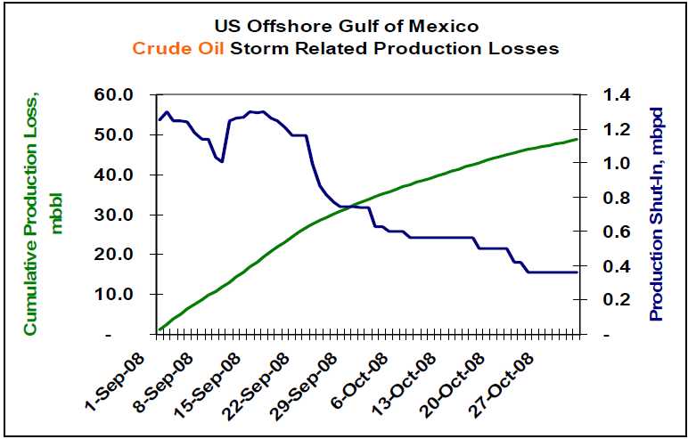
So how is the restoration effort progressing? Capstone Trading Advisors is tracking the cumulative US Offshore Gulf of Mexico production losses as reported by the US Minerals Management Service. As of 30Oct08, approximately 359.7 mbbl/day of crude oil and 2.4 Bcf/day of natural gas production continues shut-in. That equates to 27% and 33% of pre-storm production capacity, respectively. Within the last two months, cumulative production losses total 48.7 million bbls of crude oil and 253 Bcf of natural gas. See the charts below.

Lower petroleum product demand, and a corresponding reduction in refinery utilization, has cushioned the impact of this lost production. The key petroleum price drivers on a go-forward basis include 1) the depth of the global recession, 2) OPEC’s production response to lower crude oil prices, and 3) geopolitical events.

The deficit in US offshore GOM natural gas production has been made up via production from unconventional onshore sources including shale, coal bed methane and tight low-permeability formations. It is estimated that roughly 4.2 Bcf/day is being produced from these unconventional sources.

The US is expected to end the natural gas storage fill season at approximately 3.45 Tcf. The combination of storage and increased production from unconventional sources should be adequate for a normal winter season. A harsh, or early, winter could lead to significantly higher natural gas prices during the winter months. Weather is the wildcard for the natural gas market.

WEATHER NOTE

National Weather Service festival will unveil Oklahoma City Microne

NORMAN — A network of 40 weather-observing stations in Oklahoma City will be unveiled Saturday during the annual National Weather Festival in Norman.

The free festival, scheduled 9 a.m. to 1 p.m. at the National Weather Center on the University of Oklahoma research campus, also will feature hourly weather balloon launches, a storm chaser car show, a children’s activity area and a weather center open house.

The Oklahoma City Micronet dedication is scheduled for 10:15 a.m. The Micronet will have four Oklahoma Mesonet stations, along with 36 miniature weather stations installed on traffic signals throughout the city.

The Oklahoma Climatological Survey developed the Micronet in cooperation with OU and the city of Oklahoma City. The survey also runs the Mesonet, the system of more than 110 weather stations throughout the state.

Mesonet and Micronet stations record temperatures, wind speed and precipitation.

Past National Weather Festivals have attracted visitors from all over Oklahoma and other states.

The car show features vehicles ranging from weathered clunkers driven by amateur chasers to newer television-station vehicles with state-of-the-art technology.

Visitors also can see forecasters at work while touring the National Weather Center, said Keli Tarp, a spokeswoman for the National Oceanic and Atmospheric Administration’s Weather Partners.

Nearly Half of U.S. States Fail on Emergency Plan Communication, New Study Shows

ScienceDaily (Oct. 27, 2008)
Seven years after Sept. 11, and in the wake of many major natural disasters such as forest fires, hurricanes and flooding, nearly half of U.S. states either have no state-level emergency plan or do not provide it readily to the public, reveals a new study by George Mason University Communication Professor Carl Botan.

Despite federal laws that require a state emergency operations plan (EOP) as a prerequisite to some federal funding, 22 states were unable to provide Botan with an EOP, withheld the plan on security grounds or made it difficult for even trained researchers to gain access. Residents of these states, Botan says, may question their state's preparedness because they are unable to find out how the highest authorities in their state coordinate responses to major disasters or how to have a say in those plans.

"While most Americans will have access to some important state-level information during emergencies, many may not. When minutes may make the difference between life and death in an emergency situation, the population should not have to waste precious time looking for answers or who to turn to," says Botan.

The study, "Using Sense-Making and Co-orientation to Rank Strategic Public Communication in State Emergency Operations Plans," graded and ranked the state emergency operations plans of the 50 U.S. states and the District of Columbia on their communication components.

Botan analyzed the accessible state EOPs for three criteria: if the plans had a two-way communication component, if they addressed the communication needs of vulnerable populations and if they treated public communication as important enough to specifically address it in the plan.

He found that the 29 jurisdictions that do have plans available make provisions for public communication-including news releases and public broadcasts, but only 16 of them make explicit or implicit provisions for two-way public communication such as community forums and focus groups. Botan feels that two-way public communication is essential in the plans, for that will allow the state to understand what its residents feel they need in emergency situations.

Of the 29 plans obtained, only two-Washington, D.C. [which is treated as a state-level entity for this purpose] and New Mexico-received a perfect score of eight for communication.

In addition, while 16 states mentioned vulnerable publics, only 13 of these discussed specific communication strategies for these vulnerable publics in their plans. For example, California mentions specific strategies such as dispatching special teams targeting vulnerable populations like the aged and the disabled, while Arizona simply mentions that emergency managers must pay attention to "special needs" people like residents of nursing homes and the hearing impaired, but does not outline specific strategies to communicate with them.

As of 1988, all states are required under the Stafford Disaster Relief and Emergency Assistance Act to have a written EOP in order to qualify for some federal funding. "Billions of tax dollars have been spent on homeland security in the last half-decade," Botan says. "It's very important that these plans are available to the public. Otherwise residents can't be confident their needs have been thought of, and aren't sure who they can count on."

The study, co-authored by George Mason University alumni Paul Penchalapadu, is to be presented at the National Communication Association annual conference in San Diego on Saturday, Nov. 22.


MARITIME NOTE

Coast Guard rescue swimmer injured during sinking sailboat rescue

PORTSMOUTH, Va. - Coast Guard rescue crews from six different units, including three Cutters and three Air Stations, responded to a sinking sailboat with three people onboard approximately 102 miles southeast of Atlantic City N.J., Wednesday.

Rescued were Kevin Hogan, a 52-year-old and Teresa Gravie, age unknown. Phil Rubright, a 65-year-old Detroit resident was recovered but pronounced deceased by the Atlantic County Medical Examiner Office in Atlantic City.

The Coast Guard began its search after watch standers at the Rescue Coordination Center in Portsmouth received an Emergency Position Indicating Radio Beacon (EPIRB) alert and determined it was aboard the 44-foot sailing vessel FREEFALL.

After obtaining this information Coast Guard rescue crews, aboard a C-130J and MH-60 Jayhawk helicopter were launched from Coast Guard Air Station Elizabeth City, N.C.

The Elizabeth City rescue crews arrived on scene but were unable to hoist the three passengers from the FREEFALL due to the extreme weather conditions consisting of rain and 40-50 knot winds and 40-50 foot seas. The rescue crew determined that in order to conduct a safe hoist the passengers and the rescue swimmer had to enter the water. The rescue swimmer and Mr. Rubright entered the water to attempt the hoist but the rescue basket and hoist cable were damaged by a large wave.

The helicopter crew deployed a life raft and Mr. Rubright was placed in it. Reportedly another large wave hit and injured the rescue swimmer and tossed Mr. Rubright from the life raft. The injured rescue swimmer was unable to recover Mr. Rubright.

The helicopter crew employed the Emergency Recovery Device (ERD) to recover the rescue swimmer. This manual recovery device is only used during the most extreme circumstances and the person being hoisted must be trained and wear a rescue strop.

Without the means to recover Mr. Rubright the helicopter crew called for assistance and departed for Atlantic City to seek treatment for the injured rescue swimmer.

The Coast Guard then launched two MH-65 Dolphin rescue helicopter crews from Air Station Atlantic City along with a HU-25 Falcon jet and a MH-60 Jayhawk helicopter crews from Air Station Cape Cod, Mass. The 270-foot Coast Guard Cutters Northland and Seneca, along with the 87-foot Coast Guard Cutter Mako were also dispatched to the scene.

The Atlantic City helicopter crews were able to relocate the stricken vessels crew and relay the position to the incoming Cape Cod rescue crews.

Upon arriving on scene the Cape Cod helicopter crew recovered Mr. Rubright from the water and flew him to Atlantic City where he was pronounced deceased by the Atlantic County Medical Examiner.

A second MH-60 Jayhawk rescue helicopter crew from Elizabeth City was dispatched to the scene and hoisted Hogan and Gravie from the sailboat and flew them to Air Station Atlantic City where they were turned over to local EMS crews and taken to a AtlatiCare Regional Medical Center in Atlantic City for treatment.

Both Hogan and Gravie suffered from mild hypothermia and are in good condition.

This case is under investigation by the Coast Guard.

Salvors Rescue Grounded Containership with Hazardous Cargo on Board

NETHERLANDS-based towage and salvage specialist Multraship and Belgian salvage operator URS Salvage & Maritime Contracting have refloated the 39,900 gt, Singapore-flag containership Kota Lagu, which grounded in the River Scheldt with hazardous cargo on board on October 25.

The 2006-built vessel grounded after suffering rudder failure near Ossenisse on the River Scheldt, between Hansweert and Antwerp, during ebb tide. Working under a Lloyd’s Open Form agreement, Multraship and URS immediately mobilised an experienced salvage team and six tugs. The salvors tried to refloat the vessel on the same tide, but the water level had fallen too far and the operation had to wait for the next tide, at around midnight.

Because the vessel had hazardous cargo on board, local authorities declared a ‘High Alert’ situation, and the salvors accordingly made provision for a potential major incident by mobilising further tugs, salvage professionals, booms, pumps, and lighters for bunker discharge. In the event, eight tugs were able to refloat the vessel on the next tide and subsequently towed it to the Scheldepoort yard at Flushing, where it was redelivered to its owners.

Leendert Muller, managing director of Multraship, says, “This was another incident which served to illustrate the essential nature of the professional salvage industry, and the importance of having immediate access to its resources and expertise. Working closely with the local authorities, we were able to avert a potentially catastrophic outcome, given the presence on board the vessel of hazardous cargo.”

Peter Vierstraete, general manager of URS, adds, “The fact that we were able to refloat the vessel on this occasion without major incident should not disguise the continuing need to ensure that the resources are available, and in position, to deal with such emergencies.


Messing About In Ships Podcast


Have a wonderful weekend...

RS