Showing posts with label Predicting Underwater Weather. Show all posts

Monday, December 29, 2008

Sub to make deep Caribbean dive

Sub to make deep Caribbean dive

Scientists are set to explore the world's deepest undersea volcanoes, which lie 6km down in the Caribbean.

Delving into uncharted waters to hunt for volcanic vents will be Autosub6000, Britain's new autonomously controlled, robot submarine.

Once found, the life, gas and sediment around the vents - the world's hottest - will be sampled and catalogued.

The research will be carried out by a British team aboard the UK's latest research ship, the James Cook.

"We are heading out on two expeditions, each close to a month long, to map the full length of the Cayman Trough," said team leader, Dr Jon Copley of the National Oceanography Centre in Southampton (NOCS).

Dr Copley explained that the Cayman Trough, which lies between Jamaica and the Cayman Islands, is a product of the Caribbean tectonic plate pulling away from the American plate.

"It is the world's deepest volcanic ridge and totally unexplored," the Southampton-based researcher told BBC News.

Along with Autosub6000, the researchers will also rely on Isis, the UK's deepest-diving, remotely operated vehicle to scan the deep.

Double Sub

First overboard will be Autosub6000, an unmanned undersea vehicle that can go down to 6,000m and carry out a dive without being controlled from the surface.

It will be tasked with finding the volcanic vents on the ocean floor.

The second submarine to take the plunge will be the Isis.

Isis will sample fluids and sediments from around the lip of the vents to test their geochemistry, and also collect animal specimens.

Map
Britain's new robot sub will map the entire length of the Cayman Trough

"We are hoping to find several different types of vents along the ridge," said Dr Copley.

"Some of the vents will be very similar in depth to the vents we already know about, and because the conditions will be alike, we might expect very similar animals," he explained.

The researchers will look to compare the animals around the Cayman vents with those in the Atlantic and Pacific, in the hope of better understanding the processes that affect how deep-sea creatures "get about".

If the organisms in the Cayman Trough look like those from other deep volcanic trenches, it will suggest that ocean currents must play a role in shaping the patterns of deep-sea life by transporting the animals' larvae around.

However, if the Cayman Trough animals are very different from those existing in other parts of the Earth's oceans then isolation will be considered more important.

"The deep ocean is our planet's largest ecosystem. If we are going to use its resources responsibly then we need understand what determines its patterns of life," the Southampton-based researcher said.

New vents

Dr Copley told BBC News that there was also another kind of venting that was driven by a very different geological process in which the Earth's mantle is directly exposed to the water.

Arm/NOCS
The researchers will explore vents looking for deep-sea animals

This type of volcanism has only ever been seen once before, in the mid-Atlantic.

The temperatures around these hydrothermal vents were so hot because they were so deep, Dr Copley said.

"They could be hotter than 500C (930F), and if they are that hot, they will probably have quite different chemistry and life forms - we expect to find new species."

The researchers expect that, at depths greater than 3,000m, one in every two animals they come across will be a species new to science.

WEATHER NOTE

Ocean observations reap climate science rewards
Long-term observations of the oceans around Australia are providing the nation’s climate scientists with significant benchmarks for seasonal forecasts and monitoring future climate change.
15 December 2008

Initiated near the end of a two-year El Niño event in May 1983, the program involves the deployment of simple ‘expendable instruments’ (XBTs) from commercial shipping that measure temperature and currents to a depth of 800m along routes in the Indian, Pacific and Southern Oceans.

“There is so much ocean around Australia influencing our daily weather and longer term climate that it made sense to begin a record from which we could connect ocean change to shifts in rainfall patterns across southern Australia,” says Dr Gary Meyers who, with colleagues at CSIRO, the Bureau of Meteorology (BoM) and the Scripps Institute of Oceanography in the US, established the ocean monitoring system.

“The 1982/83 El Niño came as a big surprise when we saw all kinds of changes around Australia but didn’t understand them. Now these ocean temperature data contribute to the BoM’s routine seasonal climate forecast.”

At 25 years the system stands as one of the longest sustained ocean observing networks in the world, and is a rare long-term record of ocean change in the huge and poorly monitored Southern Hemisphere ocean domain.

Based on the records, CSIRO’s Dr Susan Wijffels and co-authors will publish a landmark paper on the mean currents flowing between Australia and Indonesia in the Journal of Physical Oceanography. These currents form a critical ocean interconnection – the so-called Indonesian Throughflow – in the distribution of heat in the global climate system.

“Today, we have over 60,000 measurements of temperature around Australia that scientists regularly use to assess past long-term trends – test models used to predict future climate or forecast ocean behaviour,” says Dr Meyers, who leads Australia’s Integrated Marine Observing System (IMOS). “More than 50 scientific publications and books have been published using the Australian data.”

MARITIME NOTE

USCG – Marine Safety Performance

The US Coast Guard released its Marine Safety Performance Plan for FY 2009-2014.

The plan addresses the goals of: (1) reducing the risk of marine casualties; (2) facilitating commerce; (3) improving program processes and management; and (4) improving human resource capabilities. The Marine Safety Program pursues these goals through a multi-faceted approach that includes standards development; mariner credentialing; compliance enforcement; investigations and casualty analysis; industry and public outreach; and international engagement.

The Plan is a living document and may be changed in the future to reflect the results of a currently-ongoing independent evaluation of the Marine Safety mission, scheduled for completion in March 2009. Comments on the Plan are also solicited from the regulated community and other stakeholders.

(Source: Holland & Knight)


Thursday, January 31, 2008

UNDERSEA WEATHER

Undersea Weather

The extreme weather that impacts us is now having an effect where you might least expect it - deep under the sea. As this ScienCentral News video explains, scientists have linked climate change to population booms and busts in deep-sea life.

Not-So-Sunny Underwater Forecast

Warm waters might be soothing in a bathtub or a swimming pool but when the ocean heats up it can get mighty uncomfortable, and even deadly, not only for the animals who live there but for land lovers too. Peruvian and Ecuadorean fishermen even coined a term for the warm water phenomenon in the late 1800s, El Niño, their nickname for unusual Christmastime changes in water temperature that impacted their catch; El Niño has since been shown to cause extreme weather conditions like hurricanes and droughts.

Now scientists say that El Niño and La Niña - when ocean temperature in the Equatorial Pacific grows colder than normal compared to El Niño - are not only impacting life on land and on the sea surface, but also life on the ocean floor. Deep-sea ecologist Henry Ruhl, working with colleagues at Scripps Institution of Oceanography, reported in the journal Science that changes in surface ocean climate may be impacting animal populations far under the ocean

"The sea life populations were changing in a way that suggested that climate was linked to food supply, and food supply was linked to the abundance of the animals in the seafloor on time scales that were roughly similar to what we were finding in above-water systems," Ruhl explains. "So it seems plausible that climate could be affecting the deep sea relatively rapidly, and wasn't somehow far removed in time, even though it's out of sight, out of mind to many people." But he's quick to add that more research is needed to find the specific causes of the population jumps or declines he reported.

At "Station M," 130 miles off the California Coast, the Scripps team has been studying an abyss 13,400-feet deep since 1989. They set out to document something many agree they know little about - what happens deep beneath the sea. Using a submersible camera-mounted sled that snapped photos of ocean life every five seconds, researchers tracked ten mobile animal populations, including starfish and sea cucumbers. They took ocean floor samples of nutrient-packed sludge called sediment, a mix of feces and dead phytoplankton, amongst other things, that sinks from the sea surface and provides food to animals on the seafloor. Then, the team compared sediment composition to changes in time and weather.

The information gave Ruhl a more complete picture of how deep-sea marine animals may be impacted by climate change. "We believe that food supply is one of the only plausible mechanisms for the climate to be affecting the animals on the seafloor," he says. "And we believe it's happening through a mechanism in which climate affects the productivity or the amount of sea life above the study site on the overlying surface waters."

El Nino Satelite
Satelite imaging of climate changes and ocean temperatures produced by El Nino.
image: NOAA
It's there that phytoplankton float on the ocean surface, where they grow by soaking up the sun and taking in nutrients like iron. The problem is that phytoplankton is also highly sensitive to a domino effect brought on by climate changes. During an El Niño event, wind patterns and ocean circulation change. One result is a slowdown in something called upwelling, the upward flow of cold, heavy, deep-sea water resulting when off shore currents draw warm surface water away from the coast. Upwelling floods ocean surface water with nutrients. But when this nutrient rich water fails to reach areas where phytoplankton live, as happens during an El Niño event, phytoplankton slowly starve. In turn, other sea life that depend on phytoplankton as a food source start dying too. Ruhl believes that these kinds of changes in sea surface life directly "affects the population of the animals in the sea floor."

Experts say scientists are getting better at spotting El Niño events ahead of time, even though solutions to the problem, and the subsequent impact it has on sea life, aren't so forthcoming. The National Oceanographic and Atmospheric Administration (NOAA) is one agency that tracks El Niño. Scientists there were able to predict the 1997-1998 El Niño six months ahead of its arrival, using instrumentation like satellites and ocean buoy data. Their predictions saved California over a billion dollars since the state was able to prepare for the event ahead of time.

So, should we be putting the sea cucumber up there with other endangered species? Not yet. Ruhl says that what we do with the information uncovered in the study is "really a values question...not in our lifetime will we be affected by what happens in the deep sea, other than knowing that it's happening."

It's in a hundred years or more that people will have to fish for solutions to much bigger problems down below.

MARITIME NOTES

IMO – International Ice Patrol

The IMO issued a circular forwarding a communication from the Government of the United States concerning International Ice Patrol (IIP) services for 2008. SN.1/Circ.268 (1/22/08).

ON THIS DAY IN HISTORY - THE PRINCESS VICTORIA DISASTER

"1953, Irish Sea: 130 die in ferry disaster. The inquiry concluded the ferry owners were to blame for the poor design of the stern doors which were torn open in the heavy seas. The highest civilian award for bravery, the George Cross, was given posthumously to the ferry’s radio operator, David Broadfoot, who remained at his post sending out messages for assistance until the ship sank. The captain went down with his ship."

BBC, 1953: A car ferry has sunk in the Irish Sea in one of the worst gales in living memory claiming the lives of more than 130 passengers and crew.

1


THE IRISH SEA

The Princess Victoria, a British Railways car ferry, bound for Larne in Northern Ireland, had left Stranraer on the south-west coast of Scotland an hour before when the stern gates to the car deck were forced open in heavy seas.

Water flooded into the ship and as the cargo shifted, the ferry, one of the first of the roll on-roll off design, fell onto her side and within four hours she sank. Among the passengers who perished were the Northern Ireland Finance Minister and Deputy Prime Minister Major J M Sinclair, and Sir Walter Smiles, the Ulster Unionist MP for North Down.

The Northern Ireland Prime Minister, Lord Basil Brookeborough, paid this tribute: “The waves that yesterday were mountainous are relatively calm again but they’ve become the tomb of 130 of our fellow citizens. Under this cruel stroke of fate, many families are sorrowing today, they have the heartfelt sympathy of us all.”

Captain radioed for help

Tragedy struck at 0845 GMT when Captain James Ferguson radioed the coastguard to say the ferry was “not under command and needed a tug”.

At 1252 the captain radioed to say the engine room was flooded and he had decided to abandon ship.

Later messages made clear that the ship was listing so much that it was impossible to launch the lifeboats.

One lifeboat was smashed against the ship’s side. Another, containing eight women and a child, was swamped by huge waves and sank.

RAF planes were alerted to the sinking at about 1500. They arrived at the scene half-an-hour later and dropped rubber dinghies but blinding squalls of sleet and rain hampered their efforts.

One of the lifeboatmen sent to the rescue said they spent two hours searching for survivors. One man was found clinging to a raft on which were four other people who had died from exposure.

The first survivors, including Petty Officer Jay Yeomans, were landed at Donaghadee, 20 miles east of Belfast.

Fusilier Jeoffrey Bingley was another survivor. “I didn’t expect to be alive… I was in the lower deck when the boat started to go over and I scrambled down the side of it and got into a lifeboat,” he said.

“We pushed away with about 20 on board and managed to pick a few up out of the sea. We didn’t have any oars - the sea just took its course.”

AROUND THE WORLD BY - Arthur Rabjohn CEM

CANADA: Emergency team rolls out as ice storm knocks out power to 70000. The Red Cross activated its emergency response team Wednesday after two days of freezing rain brought down power lines across Prince Edward Island, knocking out electricity to much of the province. The blackouts started Tuesday afternoon in western P.E.I. and spread eastward, with Charlottetown losing power for about three hours on Wednesday afternoon. At one point, about 70,000 residents were without electricity, including those in some communities in eastern P.E.I. As night fell, officials with Maritime Electric said service would be fully restored by Friday at the latest. Reports from the western end of the Island suggested the ice storm had caused extensive damage to the power grid. Amid toppled utility poles and ice-laden power lines, heavy fog had reduced visibility to mere metres for crews scouting for problems by snowmobile.

MALAWI: Rising floodwaters devastating the crops, livestock and infrastructure across half the coutry and menacing more than 73,000 Malawians are going to get worse, government officials said Wednesday. "It's getting worse in Malawi because it is raining everyday," said Lilian Ng'oma, a senior official in the disaster management ministry. "We expect more rains and more flooding this year".

CHINA: China's worst snowfall in decades may have a serious impact on crop production in the south of the country. The snowstorms have affected nearly 80 million people across 14 provinces. At least 38 people had been killed in snow-related accidents such as house collapses and falls. People are already experiencing shortages of food. More than a dozen provinces have also been hit by blackouts due to missed coal deliveries for power stations and rising demand amid the cold. At least 12 national highways remain blocked. Forecasters are warning of more snow and urging people not to travel.

INDONESIA: A 5.9-magnitude aftershock has rocked an eastern Indonesian province, one day after a 6.6-magnitude quake prompted a brief tsunami alert. The aftershock struck earlier today and was located 248 km northwest of Saumlaki town in Maluku province. There was no risk of a tsunami.

KYRGYZSTAN: Over half of the 5,000 people, who have been made homeless by an earthquake which struck southern Kyrgyzstan on 1 January, are still living in tents and trying to survive harsh wintry conditions. The affected people have received initial relief items, such as winterised tents, heaters, electricity transformers, and coal. This included assistance provided by the MIC. Many villagers are running low and they need more fuel to keep them warm in the extreme cold.

VANUATU: Tropical cyclone Gene struck Vanuatu, bringing 1-minute maximum sustained winds to the region of around 157 km/h. The potential property damage and flooding from a cyclone includes: storm surge generally 1.8-2.4 m above normal, minor damage of buildings, considerable damage to shrubbery and trees, coastal and low-lying escape routes flood 2-4 hours before arrival of the storm center. There is also the potential for flooding further inland due to heavy rain.

CHICAGO WEATHER

WINTER STORM WARNING IN EFFECT FROM 6 PM CST /7 PM EST/ THIS EVENING TO 6 PM CST /7 PM EST/ FRIDAY
Issued: Thursday, January 31, 2008 4:28 AM CST
Expires: Thursday, January 31, 2008 12:30 PM CST

Urgent - Winter Weather Message National Weather Service Chicago/Romeoville IL 428 AM CST Thu Jan 31 2008

...Intensifying Winter Storm Expected To Impact The Area Tonight Into Friday...

.An Area Of Low Pressure Currently Developing Over The Southern Plains Will Continue To Intensity Today...And Will Move Into Southeast Indiana By Friday Morning...And Into The Eastern Great Lakes On Friday. Snow Will Overspread Northern Illinois And Northwest Indiana Late This Afternoon Into Early This Evening With A Potential For Heavy Snow Tonight Into Early Friday Morning.

Dupage-Cook-Grundy-Will-Kankakee-Livingston-Iroquois-Ford- Lake Indiana-Porter-Newton-Jasper-Benton- Including The Cities Of...Chicago...Morris...Joliet...Kankakee... Pontiac...Watseka...Paxton...Gary...Valparaiso...Morocco... Rensselaer...Fowler 7 PM Est/ This Evening To 6 PM CST /7 PM Est/ Friday...

The National Weather Service IN Chicago Has Issued A Winter Storm Warning...Which Is IN Effect From 6 PM CST /7 PM Est/ This Evening To 6 PM CST /7 PM Est/ Friday. The Winter Storm Watch Is No Longer IN Effect.

Light Snow Will Develop Across The Area This Afternoon...But Little Or No Snow Accumulation Is Expected. Snow Will Increase IN Coverage And Intensity By This Evening As A Strengthening Storm System Across The Southern Plains Begins To Track Northeast. Heavy Snow Will Be Possible From This Evening Through Friday Morning...And Then Will Taper To Light Snow And Flurries Friday Afternoon. Storm Total Snowfall Accumulations Will Range From 5 To 7 Inches From Evanston To Morris To Pontiac To 7 To 11 Inches From Gibson City To Fowler Indiana Where Locally Higher Amounts Closer To A Foot Are Possible.

Additionally...East To Northeast Winds Will Be Increasing During The Period Leading To Blowing And Drifting Snow. The Rush Hour Commute Friday Morning Will Be Adversely Affected By These Conditions As Many Roads By Morning Will Be Slick And Hazardous. Snow Will Gradually Begin Tapering Off To Flurries By Friday Afternoon As The System Exits Towards The Northeast.

A Winter Storm Warning Means Significant Amounts Of Snow... Sleet...And Ice Are Expected Or Occurring. Strong Winds Are Also Possible. This Will Make Travel Very Hazardous Or Impossible.

RS

Wednesday, January 9, 2008

Black Sea Storms

Back on Tuesday, November 13, 2007 we reported on a severe storm that sunk several Russian ships on the Black Sea ( See Mother and Her Fury!). We recently reported on severe weather grounding the vessel Vanessa, (See Dar be Storms Ablow'in! ) and severe weather effecting Bulgaria and Romania. These at-sea storms have a deadly impact on ships and their crews while most of the incidents go unreported by electronic media outlets both in the United States and worldwide. For example, Cargolaw reported on the Vanessa,

"Bulgarian cargo M/V Vanessa, with 10 crew and a pilot aboard and cargo of scrap metal, sank in the Kertch Strait in severe seas on Jan 3 at 0600LT. There were 11 people on board the ship -- 10 Bulgarian crewmen and a Ukrainian pilot. Two ships proceeded to M/V Vanessa after its SOS-call but were unable to help due to the storm. Rescuers found only one survivor and the bodies of three crew. The bodies were taken aboard a rescue speedboat. Before the sinking the bulwark was torn from the ship. From our Sr. Correspondent Tim Schwabedissen and our Moscow Correspondent Mike Voitenko (Thurs. Jan 3 2008)."

Anyone remember seeing this report on any of the US major news outs? At-Sea Storm reports are just as critical if not even more critical than shore-side reports, since severe weather happens at sea more often than on shore. I include subsea storms or weather pattens exclusive to the oceans. Of course chasing these weather systems is not that easy either.

Chasing maritime weather systems is very different from chasing shore-side storms. Normally a seaman is not chasing, he is normally being chased or caught in the storm with limited escape possibilities. Meaning he is forced to ride out the storm. I can assure you that riding out one of these storms is not pleasant and scary. Like the old saying, "there is no atheists in a fox hole", well there are no atheists at sea either... As its been said, "Ship Happens!"

Thanks to my good friend and shipmate Captain John Konrad of gCaptain.com, These dramatic pictures are from Novembers storm.

storm in Ukraine 2


storm in Ukraine 2


storm in Ukraine 4

storm in Ukraine 5

storm in Ukraine 6

storm in Ukraine 7

storm in Ukraine 8


storm in Ukraine 6

storm in Ukraine 7


MARITIME NOTES

Cargolaw has a posting asking for assistance in solving this mystery. Dr. Beach Asks: What Vessel Lost This?

This little note from our British friends...

Gale-force winds of more than 75mph buffeted parts of Scotland and Northern Ireland today, causing flooding and danger on the roads. Ferry services between Northern Ireland and Scotland were suspended last night because of the weather conditions, which reached 78mph in the Isle of Islay off the west coast of Scotland. The Forth Road Bridge remained closed to all vehicles except cars, and Fife Constabulary said roads in the area suffered from minor flooding. The high winds would continue today, shifting further north as the day continues, leading to a bright day with blustery showers, forecaster said. The Met Office issued a severe weather warning of winds up to 80mph with the the prospect of structural damage. Tony Conlan, a forecaster with MeteoGroup, the Press Association's weather division, said the highest gust measured 78mph in the Isle of Islay. He said even stronger gusts were expected today across Northern Ireland and central Scotland. He said that by the evening most places will have seen the last of the bad weather, for now. Stena Line cancelled both fast ferry and conventional ferry services between Belfast and Stranraer because of the severe weather.

The firm warned of further possible disruptions today. Police warned of a road closure in Lisburn, County Antrim, Northern Ireland after power cables were brought down. The Foyle Bridge in Londonderry, Northern Ireland was closed to all traffic. A spokeswoman for Fife Police said: "Numerous trees have been blown down blocking the roads and we have had some minor flooding across the region. "But it has not been a disaster, it has just been a bad winter night due to high winds and sweeping rain." Rough sea conditions in the English Channel were causing delays this morning to some ferry services, the Port of Dover said. All sailings from the Eastern Docks with P&O Ferries were running about 90 minutes late. Norfolkline services to Dunkerque were also experiencing some disruption to their timetables, a port spokeswoman said.


RS

Monday, October 15, 2007

Underwater Weather Watchers

One of my favorite subjects! Underwater Weather! This is a 2005 article from the American Institute of Physics and DBIS.

We have spoken about how we humans view things on a one-plane thought process, notably what we see. While much of what effects our planet and our weather are conditions, atmospheres and environments we either do not see or in some cases cannot see, yet.

The fact is that weather is a complex science with many variables. Science is on the path to try and understand these unseen but critical factors. RS

Underwater Weather Watchers


Oceanographers, Physicists Design Submersible Floats For Eyeing Ocean Weather
January 1, 2005

Researchers are now collecting valuable information about ocean weather from a fleet of cost-effective instruments called Argo floats. Using hydraulic fluid in internal and external sacs, each float sinks about a mile and a half underwater.

Every ten days, the float rises to the surface and transmits information on the ocean temperature and salt content. Researchers hope Argo will improve the ability to forecast the paths of hurricanes and where they will make their landfall.

Why do some objects float and others sink?

Legend has it that around 200 B.C., the Greek philosopher Archimedes took the first step to determine why objects float. Archimedes noticed as he was getting into his bath that when he sat down, water flowed over the sides of the tub. His weight had moved, or "displaced," it. He concluded that water pushes upward with a force equal to the object's weight.

When an object is floating, part of it is under the water; how much of it is underwater depends its weight. For instance, if a boat weighs 1,000 pounds, it will sink into the water until it has displaced 1,000 pounds of water. The object will float unless it is too heavy to push away enough water equal to its own weight and still have part of itself above the water.

But weight is not the primary factor in determining whether something will float. After all, big ships are very heavy, yet they stay afloat. It all comes down to an object's density: Objects with lower density will float more easily than objects of higher density. The density of the liquid is also a factor.

A boat may weigh 1,000 pounds, but it is not solid steel throughout: Much of its interior is air. So the average density of a boat is very light compared to the average density of water. Filling the boat with heavy rocks will increase its density, and eventually the boat will sink when its density becomes greater than that of the water.

The American Geophysical Union contributed to the TV portion of this report.

Additional information on Argo: Underwater Weather.

Maritime Note


Another amazing USCG Rescue was brought to my attention. This also includes another reported EPIRB malfunction as both gCaptain and myself have been reporting on with regards to the s/v Sean Seamour II. I am taking a look into the
fishing vessel Illusion's report to see if there was any USCG findings..

Aleutian rescue a close call for Coast Guardsmen AWARD: Helicopter crew saved fishermen in February sinking.

The Associated Press

(Published: October 14, 2007)

KODIAK -- When rescue swimmer Wil Milam pulled into Dutch Harbor aboard the cutter Mellon on a stormy February morning for a patrol break, his task was to brief some third-graders about his life in the U.S. Coast Guard.

It was 7:30 a.m. Feb. 19 when he gathered with the kids and told them he never had used the strobe light attached to his shoulder.

He would have to eat his words later that night when he saved the lives of four fishermen at sea.

The fishing vessel Illusion and its crew of four, longlining for cod, sank by the time the rescue helicopter arrived. Milam ended up in the hospital attached to an IV, wrapped like a cocoon in blankets beneath heat lamps until he was able to recover hours later.

Milam recently returned from Washington, D.C., where on Sept. 29 he received the Capt. Frank Erickson Rotary Wing Rescue of the Year award.

The award recognized the entire crew: Milam, pilot Lt. Devin Townsend, co-pilot Lt. Cmdr. Joe Carroll and flight mechanic John Maghupoy.

POWER OUTAGE

Dressed in a Coast Guard jumpsuit, Milam told his story last week to the Kodiak Rotary.

It was about 11:30 p.m. when he and his crew finished dinner. Milam was headed back to the Mellon when he was told the HH-65 Dolphin helicopter might have to launch.

The Mellon is a cutter fitted with a helicopter pad.

He arrived at the Mellon only to find there were no lights on board the ship because there was no power. He drove to the hangar, where there also was no power, meaning the doors could not be opened. The helicopter was parked behind other aircraft. He seemed stuck.

Milam said the flight mechanic luckily was able to get the hangar doors open. The helicopter was rolled out.

Winds were blowing from 40 mph to 55 mph and the visibility ceiling was only 150 feet. Finally off the ground, the chopper had to fly low and headed west about 50 miles to the location of a signaling emergency beacon near Makushin Bay.

The seas were swelling with 15-foot waves.

Milam had done rescues before. He didn't see why this one would be different, but like the other small obstacles that day, there would be more and more that would seem to pile higher and higher.

RACE AGAINST TIME

Milam that night was the only swimmer onboard the helicopter, a standard procedure on a mission.

As the chopper hovered above the sea, Milam spotted four people in a raft. None had survival suits on; they were all in street clothes.

He was lowering four survival suits to the stranded fishermen when two of the suits were lost in the rough water.

"I had to go back in the water after the suits. Then my own suit started filling with water because the T-handle had accidentally opened," Milam said. "I was trying to get into the raft, but I could not get my lower body in. My suit was full of water. It was very cold."

Milam then tried to get hold of the basket. One hand was holding the basket; the other was stretched to the raft. The raft got away.

"It was then I pulled out my strobe light. I was thinking what I had told the students -- that I had never, ever used my strobe light before," he said.

There were five in the raft, including Milam. The survivors did not speak English; two were Hispanic and two were Russian.

There was only 15 minutes of fuel left in the chopper. Milam got back to the chopper and climbed up and down repeatedly to pluck victims out of the basket to get them aboard.

"Now nauseous, I vomited. I went down again, this time in the basket instead of the hoist," Milam said.

But the ordeal wasn't over. One of the survivors jumped to the basket, but the basket flipped over, upside down.

As if that weren't enough, the cable tangled.

"One of the guys was swimming on his stomach. Another wave broke. He gets away and the cable is looped around his neck.

"Finally, I got him into the basket. I was ready to go. Everyone was safe. But I was shivering violently when the helo scooped me into the basket.

"In the end, our crew had saved the lives of four people," Milam said.

One of the victims was suffering from hypothermia.

"Then there was me," Milm said. "The two pilots and flight mechanic saved me. Had the crew not been able to scoop me out of the water, I might not have been able to make it back. The fuel was short and I am not sure I could have survived if I would have been left on my own."

"I don't remember the flight back. Coming into Dutch, the chopper had difficulty finding the airport lights. The pilot and a paramedic walked me to the ambulance. Except for the hospital, it was over."

ALL IN A DAY'S WORK

Milam, 41, a demure man, has lived in Kodiak since 1997. He told the rescue story without fanfare, as if it was just one of those things he does in the course of his Coast Guard duties as a petty officer first class.

Milam has been on numerous rescues. He was plucking people and dogs out of the water in the aftermath of Hurricane Katrina in New Orleans. Shortly after the hurricane, Milam was on the cover of Time magazine with a dog he had rescued.

Milam is quick to point out that it takes the entire crew to save lives, not just a rescue swimmer, as portrayed in the recent movie "The Guardian." He said the movie did not focus enough on the team and the support it takes in efforts to save lives.

Milam's next stop is New York City, where Thursday he will receive the U.S. Coast Guard Foundation Award for Heroism.

ASA elects new leaders

John A. Witte, Jr., Executive Vice President of Donjon Marine Co., Inc, Hillside, N.J. has been elected President of the American Salvage Association (ASA). Mauricio Garrido, Managing Director of Salvage for the Americas for Titan, a Crowley Company, Fort Lauderdale, Fla,. has been elected ASA's Vice President, and Tim Beaver, President of Global Diving & Salvage, Inc. ,Seattle, has been elected Secretary/Treasurer.

Flag From the Bridge

Since the printing of my OPED I have received a ton of email. Some supportive, some not and some just plainly hostile. I also have received some very hostile emails because of my posting of the Ethan Allan incident. I posted that article in full because it was a very important topic to the maritime community at large, or so I thought. Since then the only thing I have not been accused of is heresy and I am sure that is coming.

This blog is a hobby to highlight storms, storms at sea and maritime incidents caused by extreme conditions, rather than just on-shore storm and damage reports. I purposely avoid politics when blogging here and even my OPED is not posted on this site. While I get nothing in return for blogging...

I am not a reporter or journalist in the professional sense and really a novice at blogging. Nor do I believe that all blogger's are reporters or journalist just because they blog. I understand copyright issues. Though many times I do try to seek permission or at least notify that i am linking pr posting a story. I do at least link to the story or note the source, if it is not mine, or make sure my readers understand that the story is sourced out. Moreover, it does not take a rocket scientist to read my blog to understand this. While some of the comments I have received lately and anonymously are plainly stupid and down right insulting.

Other than that, its simple with me if you don't like my blog don't read it. But we all have the Constitutional right to free speech with out being intimidated. If you want to leave a comment that's fine but personal attacks are what we call "Bravo Sierra" and uncalled for, besides they just get deleted and I will not reply...

RS


Friday, October 12, 2007

Underwater Wi-Fi is here

Underwater Wi-Fi is here

Will help predict weather conditions, earthquakes

Anna Lagerkvist
11 Oct 2007 14:50 GMT

The Swedish Defence Research Agency (FOI) has developed an underwater wireless technology that will help to accurately predict weather conditions, sea pollution and earthquakes.

The new wireless technology is said to be a vast improvement over traditional echo sound technology, which can only transmit data at a limited rate underwater. Originally developed for military purposes, the underwater wireless technology has been tested by the European Union to detect environmental changes in the sea.

Cheaper than echo sound

It could be particularly useful to accurately predict earthquakes, follow underwater weather patterns, and monitor sea pollution and climate changes. Using sensors at the sea bed, the wireless technology could also be utilised in oil and gas industry exploration, Tommy Öberg, director of research at FOI, told Tech.co.uk.

The new underwater wireless technology is also cheaper than echo sound, Öberg said. The new technology is capable of transmitting images, movies and sound.
tech.co.uk
Maritime Notes

Attached is the latest Notice to Mariners Published by the National Geospatial-Intelligence Agency.

Below is the link to the Notice to Mariners Web Page:

http://www.nga.mil/maritime/


USCG Airboat on Lake St. Clair Ice


RS

Friday, August 17, 2007

Three new radars to boost weather warning system

Three new radars to boost weather warning system

A new radar system will make predicting severe weather easier in the Waikato, the MetService says.

The Government has approved funding for three new radars around the North Island. The first will be installed at New Plymouth airport next June.

MetService spokesman Bob McDavitt said the new radars would give them more accurate and faster information about pending weather patterns.

The other two radars will be installed in Gisborne and the Bay of Plenty. Specific sites and dates have not yet been confirmed but they will be installed within the next three years.

The radars will cost about $10 million.

Mr McDavitt said severe thunderstorms caused significant damage very quickly, but the new radars would enable smaller and isolated towns to get plenty of warning before storms hit.

Radars were the only way to track the path and progress of tornadoes and thunderstorms.

"You could get a text about a hail storm about to come," he said. "Then you can adjust your activities to meet the message. You wouldn't drive your car down to the supermarket then."

Mr McDavitt said having more radars would have been useful during the recent Taranaki tornadoes.

"We could have told people accurately when they would clear. There would have been more information to give."

The North Island now has two radars - one in Auckland and one in Wellington.

These radars cover only 25 per cent of the North Island. The three new radars will increase coverage to 80 per cent.

"It will make weather warnings more accurate. We'll be able to warn civil defence (units) if evacuations need to be made."

The regional council Environment Waikato emergency management officer Adam Munro said the radar in Taranaki "will greatly enhance EW's existing flood warning capability, by enabling the real time tracking and monitoring of severe weather systems coming into the Waikato".

Mr McDavitt expected the technology to be fully operational within 10 years and hoped to get "everything in place" for the 2011 Rugby World Cup.

Weather Story

Hurricane Dean


Tropical Depression Erin

Erin Weakens to Tropical Depression; Torrential Rain Heads Toward Flood-Weary Parts of Texas

By ELIZABETH WHITE

The Associated Press

CORPUS CHRISTI, Texas

Tropical Storm Erin made landfall Thursday as a tropical depression, bringing torrential downpours to Houston before aiming at flood-weary central Texas.

One person was killed and another was injured when a waterlogged roof collapsed at a storage unit at a Houston grocery store, Houston Fire Chief Omero Longoria said.

Erin came ashore at about 7 a.m. at Copano Bay, about 25 miles northeast of Corpus Christi.

"We're very fortunate. We're always prepared for the worst and we pray that we're wrong," said Corpus Christi Fire Department Deputy Chief Michael Hernandez. "For the most part it looks like we dodged a bullet." (See Storm Erin Deluges Houston)

Super Typhoon SEPAT


RS

Thursday, August 2, 2007

Third in a Series; Subsea Atmospheres - Waves

Waves in the environment
By
Dr J Floor Anthoni

Without waves, the world would be a different place. Waves cannot exist by themselves for they are caused by winds. Winds in turn are caused by differences in temperature on the planet, mainly between the hot tropics and the cold poles but also due to temperature fluctuations of continents relative to the sea.
Without waves, the winds would have only a very small grip on the water and would not be able to move it as much. The waves allow the wind to transfer its energy to the water's surface and to make it move. At the surface, waves promote the exchange of gases: carbon dioxide into the oceans and oxygen out. Currents and eddies mix the layers of water which would otherwise become stagnant and less conducive to life. Nutrients are thus circulated and re-used. The large ocean currents transport warm water from the tropics to the poles and cold water the other way. They help to stabilise the planet's temperature and to minimise its extremes. For instance, because of warm ocean currents arriving from the north, the temperature of New Zealand is 3-4 degrees higher than it would be without them.

For the creatures in the sea, ocean currents allow their larvae to be dispersed and to be carried great distances. Many creatures spawn only during storms when large waves can mix their gametes effectively.

Coastal creatures living in shallow water experience the brunt of the waves directly. In order to survive there, they need to be robust and adaptable. Thus waves maintain a gradient of biodiversity all the way from the surface, down to depths of 30m or more. Without waves, there would not be as many species living in the sea.

Waves pound rocks and make them erode faster, but sea organisms covering these rocks, delay this process. Waves make beaches by transporting sand from deeper down towards the shore and by washing the sand and removing fine particles. Waves stir and suspend the sand so that currents or gravity can transport it.

Wave motion
Anyone having watched water waves rippling outward from the point where a stone was thrown in, should have noticed how effortlessly waves can propagate along the water's surface. Wherever we see water, we see its surface stirred by waves. Indeed, witnessing a lake or sea flat like a mirror, is rather unusual. Yet, as familiar we are with waves, we are unfamiliar with how water particles can join forces to make such waves.

Waves are oscillations in the water's surface. For oscillations to exist and to propagate, like the vibrating of a guitar string or the standing waves in a flute, there must be a returning force that brings equilibrium. The tension in a string and the pressure of the air are such forces. Without these, neither the string nor the flute could produce tones. The standing waves in musical instruments bounce their energy back and forth inside the string or the flute's cavity. The oscillations that are passed to the air are different in that they travel in widening spheres outward. These travelling waves have a direction and speed in addition to their tone or timbre. In air their returning force is the compression of the air molecules. In surface waves, the returning force is gravity, the pull of the Earth. Hence the name 'gravity waves' for water waves.

In solids, the molecules are tightly connected together, which prevents them from moving freely, but they can vibrate. Water is a liquid and its molecules are allowed to move freely although they are placed closely together. In gases, the molecules are surrounded by vast expanses of vacuum space, which allows them to move freely and at high speed. In all these media, waves are propagated by compression of the medium. However, the surface waves between two media (water and air), behave very different and solely under the influence of gravity, which is much weaker than that of elastic compression, the method by which sound propagates.

The specific volume of sea water changes by only about 4 thousands of 1 percent (4E-5) under a pressure change of one atmosphere (1 kg/cm2). This may seem insignificant, but the Pacific Ocean would stand about 50m higher, except for compression of the water by virtue of its own weight, or about 22cm higher in the absence of the atmosphere. Since an atmosphere is about equal to a column of water 10m high, the force of gravity is about 43 times weaker than that of elastic compression.
Surface tension (which forms droplets) exerts a stress parallel to the surface, equivalent to only one 74 millionth (1.4E-8) of an atmosphere. Its restoring force depends on the curvature of the surface and is still smaller. Nevertheless it dominates the behaviour of small ripples (capillary waves), whose presence greatly contributes to the roughness (aerodynamic drag) of the sea surface, and hence, to the efficiency with which can generate larger waves and currents. (Van Dorn, 1974)

If each water particle makes small oscillations around its spot, relative to its neighbours, waves can form if all water particles move at the same time and in directions that add up to the wave's shape and direction. Because water has a vast number of molecules, the height of waves is theoretically unlimited. In practice, surface waves can be sustained as high as 70% of the water's depth or some 3000m in a 4000m deep sea (Van Dorn, 1974).
Note that the water particles do not travel but only their collective energy does! Waves that travel far and fast, undulate slowly, requiring the water particles to make slow oscillations, which reduces friction and loss of energy.

Wave motionIn the diagram some familiar terms are shown. A floating object is observed to move in perfect circles when waves oscillate harmoniously sinus-like in deep water. If that object hovered in the water, like a water particle, it would be moving along diminishing circles, when placed deeper in the water. At a certain depth, the object would stand still. This is the wave's base, precisely half the wave's length. Thus long waves (ocean swell) extend much deeper down than short waves (chop). Waves with 100 metres between crests are common and could just stir the bottom down to a depth of 50m. Note that the depth of a wave has little to do with its height! But a wave's height contains the wave's energy, which is unrelated to the wave's length. Long surface waves travel faster and further than short ones. Note also that the forward movement of the water under a crest in shallow water is faster than the backward movement under its trough. By this difference, sand is swept forward towards the beach.

Water waves can store or dissipate much energy. Like other waves (alternating electric currents, e.g.), a wave's energy is proportional to the square of its height (potential). Thus a 3m high wave has 3x3=9 times more energy than a 1m high wave. When fine-weather waves of about 1m height pound on the beach, they dissipate an average of 10kW (ten one-bar heaters) per metre of beach or the power of a small car at full throttle, every five metres. (Ref Douglas L Inman in Oceanography, the last frontier, 1974). Attempts to harness the energy from waves have failed because they require large structures over large areas and these structures should be capable of surviving storm conditions with energies hundreds of times larger than they were designed to capture.

Waves have a direction and speed. Sound waves propagate by compressing the medium. They can travel in water about 4.5 times faster than in air, about 1500m per second (5400km/s, or mach-4.5, depending on temperature and salinity). Such waves can travel in all directions and reach the bottom of the ocean (about 4km) in less than a second. Surface waves, however, are limited by the density of water and the pull of gravity. They can travel only along the surface and their wave lengths can at most be about twice the average depth of the ocean (2 x 4 km). The fastest surface waves observed, are those caused by tsunamis. The 'tidal wave' caused by an under-sea earthquake in Chile in May 1960, covered the 6000 nautical miles (11,000km) to New Zealand in about 12 hours, travelling at a speed of about 900 km/hr! When it arrived, it caused an oscillation in water level of 0.6m at various places along the coast, 1.4m in Tauranga Harbour and 2.4m in Whitianga harbour. Note that tsunamis reach their minimum at about 6000 km distance. Beyond that, the curvature of the Earth bends the wave fronts to focus them again at a distance of about 12,000 km, where they can still cause considerable damage.

The relationship between wave speed (phase velocity) and depth of long surface waves in shallow water is given by the formula
c x c = g x d x (p2 - p1) / p2 or
c x c= g x d for water/air
where c= wave speed, g= acceleration of gravity (9.8066 m/s/s), d= wave depth (or upper layer depth, m), p2= density of water (=1) and p1= density of air (= 0.00125).
The formula states that wave speed increases with wave depth and the relative difference in density.
For an ocean depth of 4000m, a wave's celerity or speed would be about SQR(10 x 4000) = 200 m/s = 720 km/hr. Surface waves could theoretically travel much faster on larger planets, in media denser than water.


For deep water, the relationship between speed and wavelength is given by the formula:
l = g x t x t / (2 x pi)
l = t x c for all kinds of waves, substitute in above equation: t x c = g x t x t / (2 x pi)
c = g x t / (2 x pi) or t = c x 2 x pi / g or t = c x 0.641 (s)
where t= wave period (sec), f= wave frequency, l= wave length (m) and pi=3.1415...
to calculate c and l from wave period t (in sec): c = t x 1.56 m/s= t x 5.62 km/hr = t x 3.0 knot
l = 1.56 x t x t (metres)
Thus waves with a period of 10 seconds, travel at 56 km/hr with a wave length of about 156m. A 60 knot (110 km/hr) gale can produce in 24 hours waves with periods of 17 seconds and wave lengths of 450m. Such waves travel close to the wind's speed (97 km/hr). A tsunami travelling at 200 m/s has a wave period of 128 s, and a wave length of 25,600 m.
Wave speed, period and length with depthThese two diagrams show the relationships between wave speed and period for various depths (left), and wave length and period (right), for periodic, progressive surface waves. (Adapted from Van Dorn, 1974) Note that the term phase velocity is more precise than wave speed.

The period of waves is easy to measure using a stopwatch, whereas wave length and speed are not. In the left picture, the red line gives the linear relationship between wave speed and wave period. A 12 second swell in deep water travels at about 20m/s or 72 km/hr. From the red line in the right diagram, we can see that such swell has a wave length between crests of about 250m.
When the 12s swell enters 10m shallow water (follow the green curve for 10m), its speed will halve to 10m/s (left graph) and so will its wave length (right graph). But the height of the wave increases by a similar factor (not shown here).

The rougher the water becomes, the easier it is for the wind to transfer its energy. The waves become steep and choppy. Further away from the shore, the water's surface is not only stirred by the wind but also by waves arriving with the wind. These waves influence the motion of the water particles such that opposing movements gradually cancel out, whereas synchronising movements are enhanced. The waves start to become more rounded and harmonious. Depending on duration and distance (fetch), the waves develop into a fully developed sea.

Anyone familiar with the sea, knows that waves never assume a uniform, harmonious shape. Even when the wind has blown strictly from one direction only, the resulting water movement is made up of various waves, each with a different speed and height. Although some waves are small, most waves have a certain height and sometimes a wave occurs which is much higher.

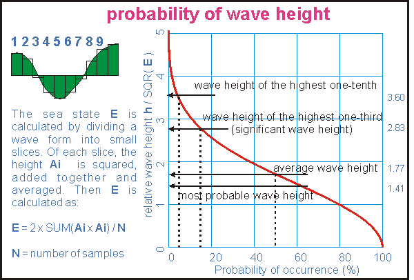
Wave height probabilityWhen trying to be more precise about waves, difficulties arise: how do we measure waves objectively? When is a wave a wave and should be counted? Scientists do this by introducing a value E which is derived from the energy component of the compound wave. In the left part of the drawing is shown how the value E is derived entirely mathematically from the shape of the wave. Instruments can also measure it precisely and objectively. The wave height is now proportional to the square root of E.
The sea state E is two times the average of the sum of the squared amplitudes of all wave samples.
The right part of the diagram illustrates the probability of waves exceeding a certain height. The vertical axis gives height relative to the square root of the average energy state of the sea: h / SQR( E ) . For understanding the graph, one can take the average wave height at 50% probability as reference.

Fifty percent of all waves exceed the average wave height, and an equal number are smaller. The highest one-tenth of all waves are twice as high as the average wave height (and four times more powerful). Towards the left, the probability curve keeps rising off the scale: one in 5000 waves is three times higher and so on. The significant wave height H3 is twice the most probable height and occurs about 15% or once in seven waves, hence the saying "Every seventh wave is highest". Click here for a larger version of this diagram.

Energy spectra for fully developed seasWhen the wind blows sufficiently long from the same direction, the waves it creates, reach maximum size, speed and period beyond a certain distance (fetch) from the shore. This is called a fully developed sea. Because the waves travel at speeds close to that of the wind, the wind is no longer able to transfer energy to them and the sea state has reached its maximum. In the picture the wave spectra of three different fully developed seas are shown. The bell curve for a 20 knot wind (green) is flat and low and has many high frequency components (wave periods 1-10 seconds). As the wind speed increases, the wave spectrum grows rapidly while also expanding to the low frequencies (to the right). Note how the bell curve rapidly cuts off for long wave periods, to the right. Compare the size of the red bell, produced by 40 knot winds, with that of the green bell, produced by winds of half that speed. The energy in the red bell is 16 times larger!
Important to remember is that the energy of the sea (maximum sea condition) increases very rapidly with wind speed, proportional to its fourth power. The amplitude of the waves increases to the third power of wind speed. This property makes storms so unexpectedly destructive.

The biggest waves on the planet are found where strong winds consistently blow in a constant direction. Such a place is found south of the Indian Ocean, at latitudes of -40º to -60º, as shown by the yellow and red colours on this satellite map. Waves here average 7m, with the occasional waves twice that height! Directly south of New Zealand, wave heights exceeding 5m are also normal. The lowest waves occur where wind speeds are lowest, around the equator, particularly where the wind's fetch is limited by islands, indicated by the pink colour on this map. However, in these places, the sea water warms up, causing the birth of tropical cyclones, typhoons or hurricanes, which may send large waves in all directions, particularly in the direction they are travelling.
For the complete series visit: Seafriends.org

Weather Story;

Typhoon Usagi is tracking closer to Japan and expect to hit the island today. To top that one, a small tsunami hit the Japanese Island of Hokkaido, no damage was reported. Tropical Storm Eric is still spinning in he eastern pacific and TS Chantel is off the NHC radar.


RS


Monday, July 23, 2007

Forecasting Dangerous Waves

Lets meet another brand of storm chaser. Unlike the ones we see chasing tornado's, these storm chasers are chasing something we normally do not see right away and that causes havoc and hell on water.

We have talked about rogue and dangerous waves. I have and will continue to post some extraordinary pictures and videos of these waves and what they can do to ships, cargos and lives. Today I want to talk about the potential of forecasting dangerous waves. This would be indeed a ma jor advancement and benefit to both meteorology and the maritime communities.

The study of rogue waves is just getting underway. As I have noted Dr. Paul C. Liu of NOAA's Great Lakes Environmental Research Laboratory (GLERL) has been studying these waves. GLERL has also been studying wave forecasting for the Great Lakes Region.

According to GLERL, " This project is designed to develop and fully implement a system of computerized models that can simulate and predict the three-dimensional structure of currents, temperatures, water level fluctuations, wind waves, ice, and sediments in the Great Lakes. The project will integrate these models with the required observational data systems into a real-time coastal prediction system. The project will make the information developed from this system available in a useful format and in a timely fashion to National Weather Service (NWS web site) forecasters, coastal users and resource managers".

NOAA/NWS has both a Ocean Prediction Center and Wavewatch III . But neither of these services accurately report on waves inside the Gulfstream. Why is this important? Currents or "moving water" play a important role in both effecting and determining dangerous waves. Why don't they report? Well its complex, they can to some degree but the technology is also not there yet to satisfy the powers to be. Maybe NOAA should consider this rather than spend $100 million on public relations? So lets take a look at another concept being proposed in wave forecasting called the; Gulfstream Hazard Scale, by professional satellite Oceanographer Jenifer Clark and husband Meteorologist Dane Clark.

In a letter date 18 July 2007 to the Director of the National Centers for Environmental Prediction, the Clark's state, "
We have become increasingly alarmed by the large numbers of vessel sinkings and loss of life and property in the Gulfstream along the U.S. East Coast over the past several years. Just this spring, four more boats were sunk and four people were killed during an east coast storm that later became Tropical Storm Andrea -- even though this system was well forecast by NWS forecast models."

After talking with hundreds of mariners who have sailed in these waters over the years and recently completing a research report for a court trial involving the cruise liner "Norwegian Dawn", which was severely damaged with 400 passenger injuries in April 2005 after encountering 40-70 foot steep waves in the Gulfstream; we have concluded that mariners are not being adequately warned about the pote ntial danger when strong winds oppose strong ocean currents in the Gulfstream System (the main Gulfstream and eddies).

In the case of the Dawn, the Captain of that vessel testified that they had no idea they were sailing into those horrific conditions (see attached graphic). NWS forecasts indicated strong winds to 50 kts and significant wave heights to 27 feet, which were good forecasts outside the Gulfstream, but in the Gulfstream, seas were more than double that and these waves were much steeper and more difficult to navigate. Notations in the marine forecasts indicating "waves higher in the Gulfstream" were not very useful and mostly ignored since they are repeated in many offshore forecasts on a daily basis and contain no actionable data the mariner can use regarding the height or danger of these waves and their exact location.

Based on these and other cases we have examined, we feel that improvements are needed to alert mariners about specific threats about extreme and dangerous waves that exist in Gulfstream waters during these severe weather events,
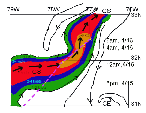
The highest risk area corresponds to the area of maximum ocean currents flowing northward (estimated at 5 kts) and winds recorded on the Dawn between 4-6AM on 4/16 at 50-55 kts blowing from the north. This is where an estimated 60-80 foot wave struck the Dawn and caused most of the damage and injuries. Wave heights were observed to be as high as 40-45 feet through the Gulfstream waters that night before the larger, steeper wave hit the ship.

Recent international research efforts to examine extreme wave events, termed MaxWave, have concluded that dangerous extreme waves are much more common than historically believed (and not uncommon, as the terms "freak wave" and "rogue wave" would imply). The studies further stated that current technology is incapable of precisely forecasting these extreme waves at present, but that there are areas around the world that are known "hot-spots" for extreme waves, like the Gulfstream, where strong winds often oppose strong ocean currents.
".


(Route ( chart above ) of the Norwegian Dawn (purple) on April 15-16, 2005 superimposed on Jenifer Clark's high resolution Gulfstream Analysis. The gulfstream maximum current is indicated by large black arrows, isolines of the estimated magnitudes of ocean currents are color coded and small arrows indicate the direction of flow of all ocean currents on this meso-scale chart.)

Therefore, using our experience and information from other mariners, we have developed a Gulfstream Hazard Scale which is similar to other environmental scales (tornados, hurricanes, river rafting, avalanches, etc.,) used to educate, alert and warn.

An important aspect of this scale is the increased potential for extreme waves, as the scale increases from Cat 0 to Cat 8. These are correlated to specific recommended responses to the risk, or threat levels.

This scale is a concept and has not been used operationally. Since it is subjective in nature, we expect that modifications may be needed before it could be used to develop warning products. The most important parameters required are detailed, real-time ocean surface currents in the Gulfstream area (Jenifer has been doing this on a daily basis for nearly 30 years) and real-time and forecasts of meso-scale surface winds (available from the NWS models).

We would like to sit down with your staff and discuss the possibilities of the NWS using this scale (or a modified version) in your operations, possibly on a trial basis next year. We envision a graphical product similar to the Mariner's 1-2-3 Rule for Tropical Storms, to warn mariners of high risk areas in the Gulfstream during severe conditions. This type of precise warni ng, containing risk levels for exact locations and times, should greatly improve the mariner's ability to understand and perceive the danger. This should in turn, motivate the Captain/Navigator to avoid these threat areas, resulting in reductions in life and property losses."

As you can read in the Clark's letter and as I have pointed out in some of my past posts, the Hatteras Trench region is a very well known maritime grave yard due to the storms fueled by the gulfstream and its winds. As we can read in their letter, we do have a hole in assisting mariners in forecasting these events. Some of the factors involved in the proposed Gulfstream Hazard Scale will include;

CAT - Categories 0-8, Risk - Threat to vessels from extreme or dangerous waves -- WD/OP/CUR - wind opposing the current. DUR - duration and fetch of the wind. SIG/WV/HGT - significant wave height (as per the international definition) -- an average maximum of the highest third of the waves in the wave spectrum, X/WAVS - Extreme wave potential, Marine/Guide - situation and recommended actions per category, (*) - generally taken as surface winds blowing against or quartering against the flow of the gulfstream currents (main stream or eddies).

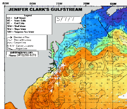
Note in the graphic above the stream encompasses both the main core (corps) and the eddies, something many mariners sometimes forget or just ignore. Now take a look at the cold eddies (below) during the 7 May 2007 Substropical storm andrea, when the s/v Sean Seamour II ran into trouble. Being able to predict the type of waves that the Sean Seamour II ran into, could have saved the sail boat from destruction and the crew from any hardships.


Also note the opposing winds to current from both northern quadrants . Remember strong winds in one direction with strong currents in the opposite direction can produce some very strong and active waves. Though some studies have shown that strong winds blowing from any directio n over gulfstream currents can also cause dangerous wave actions.

Its really this simple. Strong winds, strong currents, over time, means, very large waves. Its about being able to warn mariners in advance about these waves that can save ships, cargos and especially lives.

For further information on the Gulfstream Hazard Scale please visit,
Jenifer Clark's Gulfstream.

RS

Thursday, July 19, 2007

Second in a Series; Subsea Atmospheres

To continue my series on the topic of subsea atmospheres. Not only will we focused on underwater weather systems of our oceans, but also how subsea atmosphere's extend and effect our bays.

To continue with my series here is a interesting article titled;

Predicting Underwater Weather,
By Michael W. Fincham,


There's a weather under the Bay, complete with high-pressure systems, low-pressure systems, several kinds of fronts and two kinds of slow-moving jet streams. Think of physical oceanographers as meteorologists of this underwater world. As they figure out the physics that controls the system, they should be able to predict the underwater weather more accurately - and take a lot of guesswork out of the forecasting game that so many people have to play.

Like a band of robots, CBOS buoys stand watch over the Bay. Some stay on station year after year, like the one off the Choptank River. Others come and go, moved to monitor a particular area, or pulled for fear of ice. Shown on the map are a string of buoys, some on station and some still proposed, waiting for the region's next investment in remote sensing. Artwork by Bill Boicourt.

Those were the selling points when Chesapeake Bay Observing System (CBOS) began - better physics and better forecasting. Over the last 15 years, Bill Boicourt has kept the system running despite hurricanes, lightning strikes, icy winters, vandalism and up-and-down funding cycles. Funding so far has come from more than three dozen sources. That's a lot of grant writing, but it has allowed Boicourt to keep buying new buoys, rebuilding old ones and restocking them with the latest in advanced sensing gear. In years of good funding he's had seven buoys taking data simultaneously.


Physics and forecasting, according to Boicourt, are still the selling points for CBOS-like systems expanded to cover the entire Bay and the Mid-Atlantic coastal waters. CBOS may soon morph into a newer, larger network of buoys and land-relay towers, capable of relaying even more real-time data about the weather above and below the Bay. The results could boost Chesapeake Bay science and help protect the Maryland economy.

If the future arrives according to Boicourt's forecast, CBOS could evolve into a cooperative regional system with more stable funding and more partners from academe, state and federal government, and private corporations. Players could include the Virginia Institute of Marine Science (VIMS), Old Dominion University, the Environmental Protection Agency, NOAA's National Ocean Service, the U.S. Navy, the U.S. Coast Guard, the Alliance for Coastal Technologies, and state agencies in Maryland and Virginia. The result would be a cooperative system, perhaps with a new name, that would provide real-time weather and water data from the head of the Bay all the way out onto the Continental Shelf.

There are even larger plans afloat. Congress is now considering a proposal for funding and expanding systems like CBOS and linking them together into a larger coastal network. That could mean more money and more acronyms. CBOS might be renamed and linked into something called IOOS (Integrated Ocean Observing System) or C-GOOS (Coastal Global Ocean Observing Systems), both of which would be part of an overall system called GOOS. Those plans drew a major endorsement last week in the Preliminary Report of the U.S. Commission on Ocean Policy.

The science prize is long-term data that oceanographers can use for figuring out the physics of the Bay and other coastal systems in greater detail. Better forecasts are also in those details, especially details about water temperatures, winds on the Bay, waves and currents that result from those winds.

The practical prizes are real-time products forecasting what the system is doing today and tomorrow. That's important for big commercial shippers who need to know water levels up in Baltimore Harbor and small recreational boaters who want to know wave conditions out on the mainstem. Real-time models of current flows would help with search-and-rescue missions and with emergency responses to natural disasters like storm surges and human accidents like oil spills and chemical leaks. CBOS can even help with Homeland Security with high-frequency radar that helps track large and small ships as they move about the Bay.

In my next installment we are going to talk about a new potential concept that will help warn mariners of large and dangerous waves. The Gulfstream Hazard Scale. Under development by a Oceanographer and Meteorologist, Jenifer and Dane Clark.

RS