Showing posts with label Freak Wave. Show all posts

Monday, December 22, 2008

JPL says: FORGET LA NINA: OSCILLATION RULES AS THE PACIFIC COOLS

JPL says: FORGET LA NINA: OSCILLATION RULES AS THE PACIFIC COOLS

PASADENA, Calif. —
The latest image of sea-surface height measurements from the U.S./French Jason-1 oceanography satellite shows the Pacific Ocean remains locked in a strong, cool phase of the Pacific Decadal Oscillation, a large, long-lived pattern of climate variability in the Pacific associated with a general cooling of Pacific waters. The image also confirms that El Niño and La Niña remain absent from the tropical Pacific.
he image is based on the average of 10 days of data centered on Nov. 15, 2008, compared to the long-term average of observations from 1993 through 2008. In the image, places where the Pacific sea-surface height is higher (warmer) than normal are yellow and red, and places where the sea surface is lower (cooler) than normal are blue and purple. Green shows where conditions are near normal. Sea-surface height is an indicator of the heat content of the upper ocean.

The Pacific Decadal Oscillation is a long-term fluctuation of the Pacific Ocean that waxes and wanes between cool and warm phases approximately every five to 20 years. In the present cool phase, higher-than-normal sea-surface heights caused by warm water form a horseshoe pattern that connects the north, west and southern Pacific. This is in contrast to a cool wedge of lower-than-normal sea-surface heights spreading from the Americas into the eastern equatorial Pacific. During most of the 1980s and 1990s, the Pacific was locked in the oscillation’s warm phase, during which these warm and cool regions are reversed. For an explanation of the Pacific Decadal Oscillation and its present state, see: http://jisao.washington.edu/pdo/ and http://www.esr.org/pdo_index.html

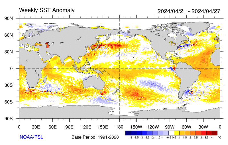
Sea-surface temperature satellite data from the National Oceanic and Atmospheric Administration mirror Jason sea-surface height measurements, clearly showing a cool Pacific Decadal Oscillation pattern, as seen at: http://www.cdc.noaa.gov/map/images/sst/sst.anom.gif

“This multi-year Pacific Decadal Oscillation ‘cool’ trend can cause La Niña-like impacts around the Pacific basin,” said Bill Patzert, an oceanographer and climatologist at NASA’s Jet Propulsion Laboratory, Pasadena, Calif. “The present cool phase of the Pacific Decadal Oscillation will have significant implications for shifts in marine ecosystems, and for land temperature and rainfall patterns around the Pacific basin.”

According to Nathan Mantua of the Climate Impacts Group at the University of Washington, Seattle, whose research contributed to the early understanding of the Pacific Decadal Oscillation, “Even with the strong La Niña event fading in the tropics last spring, the North Pacific’s sea surface temperature anomaly pattern has remained strongly negative since last fall. This cool phase will likely persist this winter and, perhaps, beyond. Historically, this situation has been associated with favorable ocean conditions for the return of U.S. west coast Coho and Chinook salmon, but it translates to low odds for abundant winter/spring precipitation in the southwest (including Southern California).”

Jason’s follow-on mission, the Ocean Surface Topography Mission/Jason-2, was successfully launched this past June and will extend to two decades the continuous data record of sea surface heights begun by Topex/Poseidon in 1992. The new mission has produced excellent data, which have recently been certified for operational use. Fully calibrated and validated data for science use will be released next spring.

JPL manages the U.S. portion of the Jason-1 mission for NASA’s Science Mission Directorate, Washington. JPL is managed for NASA by the California Institute of Technology in Pasadena.

WEATHER NOTE

New hurricane chief restores the calm after in-house storm

Bill Read didn't ride into town with both guns blazing. But in his own quiet way, he did restore order.

For much of last year, the National Hurricane Center was in turmoil, following a staff revolt against then-director Bill Proenza. Congress feared the discord might hurt forecasts, and the normally staid institution was thrust into controversy.

Today, that episode has all but subsided, and the center has refocused on tracking tropical systems. Insiders credit Read, the new director, with soothing frayed nerves and rebuilding chemistry.

"Bill knows it's not all about one man, it's not all about the director," said Max Mayfield, the popular former director of the center. "In that way, he's very much like me."

Senior hurricane specialist Lixion Avila described the atmosphere inside the hurricane center these days as "very nice."

"The most important thing is that every time we make a decision, we make it together as a team," Avila said. "He listens to the specialists, and we listen to him."

Intimidation and warning

Read, 59, a National Weather Service veteran forecaster and manager, was recruited to be the center's acting deputy director in August 2007.

That was after Proenza alienated the staff, both by intimidating employees and warning that the demise of a weather satellite would hurt storm predictions, according to an independent report.

Top management at the National Oceanic and Atmospheric Administration, which oversees the hurricane center, removed him as director in July 2007. Proenza was returned to his former job as director of the Southern Region of the National Weather Service.

NOAA officials named Read as the hurricane center's director in January.

As a result of the Proenza ordeal, the center still is making adjustments, Read said. The management structure is being organized and consultants are working with employees to address lingering morale problems.

"That was a pretty traumatic event for the folks who worked here," Read said. "I don't think everyone's totally moved on from that event."

For the most part, he added, operations have returned to normal and forecasts were never compromised. That was evident over the course of the 2008 season, when specialists generated several on-target storm predictions, for instance with Hurricane Gustav, which hit near New Orleans.

"I'm happy with where we're at," Read said of his forecasting team's performance. "I'm very satisfied with the work ethic and the attention to detail."

Noting that his management style is rather low key, Read said he doesn't intend to make any major changes in the way the hurricane center does business. Rather, he is trying to restore a sense of calm at the center in southwest Miami-Dade County.

"More and more I'm going to be working on inputting my management style, which tends to be a calming influence," he said.

Boosting morale

In the past season, whenever storms emerged, Read made a point of watching over the shoulders of his forecasters as they worked up tropical predictions. He did so to learn the intricacies of hurricane forecasting as well as to boost the morale of his specialists.

"That way I know what's going on," he said. "They know I'm interested in what they're doing."

The ultimate goal, he said, is to improve forecast accuracy, particularly with intensity predictions, an area where the center has struggled. Considering no hurricanes pulled any major surprises, he said his first season as the hurricane center's director was a good one.

"We didn't have one of those Mother Nature gotcha moments, where the storm threw a curve at us in close," he said. "I got a good break-in year."

MARTIME NOTE


Back in 2005, the Norwegian Dawn was cruising off the coast of Georgia when it was hit with a shock. A 70-foot wave crashed into the bow of the ship, flooding about 60 cabins and injuring about four passengers. The damage "was not extensive and the ship was quickly repaired," according to Wikipedia. Five years earlier, a 70-foot wave slammed into the cruise ship Oriana, destroying windows.

Dangerous waves like those aren't common, thankfully. A study of radar data from oil platforms estimated that merely 10 waves more than 75-feet-high appeared around the globe during one recent three-week period.

The bad news is that there's almost nothing that a cruise ship captain can do to either predict or avoid these waves, which rise up to five times as high as the waves around them. These rogue, or freak, waves appear to come from an angle that's out of sync with the wind and other sea waves. You'll occasionally find these waves out in the sea but also in near-beach areas, both in sandy and rocky shores. Lots of tragedies occur yearly all around the world.

To learn more about these waves, I did an e-mail interview with Paul C. Liu, who retired last year from his post as research physical oceanographer for NOAA and who blogs at Freaque Waves.

What should cruise passengers know about the frequency of dangerous waves, and exactly what type of waves are likely on the open seas?
I guess all kinds of waves are likely on the open seas, including freaque waves. They are not always happening. Most of the time they are not! But we just cannot rule out the fact that freaque waves can happen at any time and at any place. Cruise passengers should just be mindful that the possibility is there and continue to enjoy the cruise. Even if an encounter does happen, the damage will likely to be not extensive. The kind of fiction as shown in the movie Poseidon will not ever happen in real life!

What is a "freaque wave", what is its most typical origin or cause, and why do you use that nomenclature of "freaque" instead of using the term "rogue" or something more scientific sounding?
Freaque is a portmanteau word formed by the two frequently and synonymously used words of rogue and freak in describing the kind of unexpected and unpredictable waves. Many people in the scientific literature are fond of using the expression "freak or rogue waves." I choose to use "freaque waves" instead.

Are there any particular waters in particular regions that are known to be prone to freaque waves?
The short answer is no. Because of the conjecture that when ocean waves propagating into oncoming strong ocean current field might lead to the forming of large waves, regions along the Gulf stream in the North Atlantic, along the Agulhas currents in South Indian Ocean, and along the Kuroshio in Northwest Pacific, are thought to be prone of freaque waves. But areas that don't have strong ocean currents, such as the North Sea, can also have frequent freaque waves. So the talk of regional proneness is at most covering a part of the story.

What's the essential dispute about freaque waves in the scientific community? And is there something that makes scientists groan when they read accounts of waves striking cruise ships because the statements are misleading or hyperbolic or inaccurate?
Because the study of freaque waves is still relatively new, I don't think there is as yet any "essential dispute" per se in the scientific community. Lack of general consensus, maybe! Different scientists may have different concept of what "rare" or "frequent" means or using relatively different definitions for freaque waves. And there are may be different approaches to the problem. Some treats freaque waves as a part of the study of extreme waves whereas some others do not. (Freaque waves are always extreme waves, but not all the extreme waves are freaque waves!)

What's the most typical misunderstanding of the freaque wave issue, as you've encountered it when reading media reports or talking with others?
Oh yes, the media! I don't have much respect for the present day, so called, "main-stream" media. Here's an example—a paragraph from a New York Times article about freaque waves a couple of years ago:

Enormous waves that sweep the ocean are traditionally called rogue waves, implying that they have a kind of freakish rarity. Over the decades, skeptical oceanographers have doubted their existence and tended to lump them together with sightings of mermaids and sea monsters.

Rogue waves are known to happen momentarily. They appear out of nowhere. A wave takes place, and then disappears like nothing has happened. Waves like that never, yes, never, "sweep" the ocean. There is no such thing as "traditionally called rogue waves." Rogue wave is a fairly recent term. The use of the term "freak wave" was started by U.K. scientist Laurence Draper in 1964. There was no firmly established term before 1964. The existence of unusually large, great waves was nevertheless very much on the minds of every seagoing oceanographer. I don't think anyone in their right mind would "lump them together with sightings of mermaids and sea monsters." I just hope your readers beware of this kind of irresponsibility.


3 More days til Christmas!http://library2.nalis.gov.tt/Portals/0/601/christmas%20tree.jpg

RS

Wednesday, November 5, 2008

Recent Hurricane History Provides Diverging Interpretations On Future Of Hurricane Activity

Recent Hurricane History Provides Diverging Interpretations On Future Of Hurricane Activity

ScienceDaily (Nov. 2, 2008) — In a paper published in the journal Science, scientists Gabriel A. Vecchi of NOAA's Geophysical Fluid Dynamics Laboratory, Kyle L. Swanson of the University of Wisconsin - Milwaukee Atmospheric Sciences Group and Brian J. Soden from the University of Miami's Rosenstiel School of Marine and Atmospheric Science teamed up to study hurricane data observed over more than 50 years.

The study explores the relationship between sea surface temperature (SST) and seasonal hurricane activity, and show how differing interpretations of the observational record can imply vastly different futures for Atlantic hurricane activity due to global warming. The two interpretations arise from assumptions of whether it is the local SST in the Atlantic in isolation, or whether it is the SST in the Atlantic 'relative' to the rest of the tropics, that drives variations in Atlantic hurricane activity.

If one assumes the former (the local SST hypothesis), then by 2100, the lower bound on Atlantic hurricane activity is comparable to that of 2005, when four major hurricanes struck the continental United States, causing more than $100 billion in damage. The upper bound exceeds 2005 levels by more than a factor of two. However, if one assumes the latter (the relative SST hypothesis), then the future is similar to the recent past, with periods of higher and lower hurricane activity relative to present-day conditions due to natural climate variability, but with little long-term trend.

The statistical relationship between either interpretation of the SST/hurricane activity link is ambiguous over the period 1946-2007 (they are statistically indistinguishable, though both are significant), but they imply fundamentally different projections for the future and interpretations of the past. The team further argues that the consistency between theory, numerical models, and historical observations offers compelling evidence that the 'relative' SST hypothesis is more accurate and provides a better framework for projections of future changes in hurricane activity.

WEATHER NOTE

Massive waves a mystery at Maine harbor

Dockworker Marcy Ingall saw a giant wave in the distance last Tuesday afternoon and stopped in her tracks. It was an hour before low tide in Maine's Boothbay Harbor, yet without warning, the muddy harbor floor suddenly filled with rushing, swirling water.

In 15 minutes, the water rose 12 feet, then receded. And then it happened again. It occurred three times, she said, each time ripping apart docks and splitting wooden pilings.

"It was bizarre," said Ingall, a lifelong resident of the area. "Everybody was like, 'Oh my God, is this the end?' " It was not the apocalypse, but it was a rare phenomenon, one that has baffled researchers. The National Weather Service said ocean levels rapidly rose in Boothbay, Southport, and Bristol in a matter of minutes around 3 p.m. on Oct. 28 to the surprise of ocean watchers. Exactly what caused the rogue waves remains unknown.

"The cause of it is a mystery," said National Weather Service meteorologist John Jensenius, who first reported the waves from a field office in Gray, Maine. "But it's not mysterious that it happened."

Specialists have posed a variety of possible explanations, saying the waves could have been caused by a powerful storm squall or the slumping of mountains of sediment from a steep canyon in the ocean - a sort of mini tsunami. The last time such rogue waves appeared in Maine was at Bass Harbor in 1926.

Jensenius said the occurrence is so unusual, that specialists don't have a name for the phenomenon.

"That's part of our problem," he said.

A similar occurrence in Florida more than 15 years ago continues to baffle researchers. A series of 12- to 15-foot waves hit Daytona Beach on July 3, 1992, injuring more than 20 people and lifting and tossing dozens of cars.

Jeff List, an oceanographer at the US Geological Survey at Woods Hole said he and other researchers studied the occurrence, but no one has been able to pinpoint the cause. And he said similarly enormous waves appeared once on the Great Lakes.

Could such a wave or waves enter Boston Harbor, or even engulf the Massachusetts coast?

"It seems a little unlikely one could hit Boston," List said. "But then again, these things are always surprises when they occur."

A squall line surge, which occurs when fast-moving storm winds sweep over water that is traveling the same speed, can create such a wave. (The speed of waves is directly related to wind speed and the depth of the ocean at any given point.)

List and other specialists said such an occurrence is exceedingly rare, but when it occurs, "you get this interaction that causes a large bulge of water to rise up."

Jensenius said that might have been a factor last week, when a major storm front brought rain to most of the East Coast, particularly southern New England. But he said that does not solve the mystery, adding that he had not ruled out a massive "land slump" underwater. Such slumps can create waves that may be classified as tsunamis, although no where near the size and scale of the tsunami that occurred in the Indian Ocean in 2004. Those fast-moving and deadly waves were caused by a massive earthquake.

Tsunami-like waves may not be as rare on the East Coast as most people think. Jensenius referenced a 2002 article in the International Journal of the Tsunami Society that called the threat of tsunami and tsunami-like waves generated in the Atlantic Ocean "very real despite a general impression to the contrary."

The article said such waves appear "in most cases to be the result of slumping or landsliding associated with earthquakes or with wave action associated with strong storms."

Explosive decompression of underwater methane could also be a factor.

Jensenius said he is trying to gather information on the waves that hit Boothbay Harbor, adding that he has asked local businesses such as banks whether the event might have been recorded on security videos.

"It could be this or it could be that, but as a science, it is very difficult to tie it down," he said of the waves.

List also said the waves could have been triggered by the same conditions that cause a tsunami, including a breaking glacier. Rogue waves can result from a tsunami traveling through the ocean that breaks "down into numerous waves."

According to the National Weather Service, no earthquakes or seismic activity were reported in the area when the Boothbay waves appeared. List noted that there was no seismic reading when the Daytona waves struck.

Tom Lippmann, an oceanographer in the Marine Sciences Department at the University of New Hampshire, said he also suspected that the Maine wave was a squall line surge. The National Weather Service incorrectly called it a tide surge, he said.

"Tides in the Gulf of Maine are essentially driven by celestial bodies' pull on the earth's water," he said. "They're very well predicted and very well known."

Residents and business owners in Boothbay said they were glad the phenomenon didn't happen at high tide, when it might have caused massive flooding and more extensive damage. Janice Newell, who lives nearby in Head of the Harbor, told the local newspaper the rushing water "was of biblical proportion."

"There were three large whirlpools in the inner harbor, up to within a foot of my neighbor's wall," she told the Boothbay Register. "It was beautiful, but it was scary."

Elena Smith, a waitress and part-owner of McSeagull's restaurant overlooking the harbor, said the late-afternoon lunch crowd sat speechless as the waters rose and receded. She was stunned to see the normally safe and placid harbor suddenly run like rapids. Some residents reported seeing massive whirlpools of water that disappeared, leaving clam shells and seaweed in vortex patterns on the harbor floor.

"It felt like somebody took the plug out somewhere" in the ocean, Smith said. "It felt like there must have been water missing in the ocean someplace."

MARINE NOTE

Cosco Busan incident spurs search for safety

It was the mariner's worst nightmare - from the bridge of the container ship Cosco Busan, Capt. John Cota, the man who was in charge of navigating the vessel, could see one of the towers of the San Francisco Oakland Bay Bridge looming out of the fog.

He was headed right for it. The Cosco Busan is 901 feet long - longer than the Transamerica Pyramid is tall - and the ship's diesel engine, which generated 77,600 horsepower, was set on full speed ahead. There was no way to stop. Cota took quick evasive action, but the Cosco Busan sideswiped the tower, ripping a hole on the left side of the ship, spilling 53,000 gallons of heavy fuel oil that fouled miles of shoreline and killed nearly 3,000 birds.

That was a year ago this Friday.

The question is: Could it happen again?

"Absolutely," said Kelly Sweeney, a ship captain who writes a column for Professional Mariner magazine.

The main question is not how to prevent accidents - there will always be plane crashes and train wrecks, for example - but how to minimize the risks.

Experts say there are three ways: restrict operations of large ships in poor visibility, provide better tools to pilots, and construct better protections for the footings of bridges and other structures.

The Cosco Busan accident cost more than $90 million so far and Cota faces criminal charges in federal court. The accident also damaged the careers of several Coast Guard officers, and is likely to cost Regal Stone Ltd., which owns the ship, and Fleet Management Ltd., which operated it, millions of dollars.

There have been congressional hearings, and several investigations. A report by the National Transportation Safety Board and the Coast Guard into the cause of the accident is due in January.

"This is the most investigated accident ever," said Capt. Peter McIsaac, president of the Bar Pilots Association. Only the Exxon Valdez spill in Alaska, which had a much larger environmental impact, was more closely investigated.

A report by the state Board of Pilot Commissioners found seven serious errors in Cota's piloting of the ship and concluded that "pilot misconduct was a factor" in the accident.

Cota, 60, is a veteran ship's officer who had been a pilot for more than 25 years. He had taken big ships under the Bay Bridge hundreds of times. "Oh yeah, it was so foggy," he said later, his voice picked up by the ship's recording system. "I shouldn't have gone."

The role of the pilot

The report and the subsequent investigations raise serious questions about the role of ship pilots and how to reduce the risk of another encounter between a big ship and a fixed object, an event that is technically called an allision.

Pilots are experienced mariners, required to have command experience at sea, or on tugboats, and qualified for both a federal ship master's license and a state piloting license.

It is a select community. There are only 60 members of the San Francisco Bar Pilots Benevolent and Protective Association, which dates from 1850. They handle about 9,000 ship movements a year, in and out of the Golden Gate, on San Francisco Bay and its tributaries and up the rivers as far as Sacramento and Stockton.

New pilots go through an extensive selection process and then a training period that lasts a minium of 18 months. Pilots are well paid: upwards of $400,000 a year in most cases.

They provide local knowledge and guidance to the masters of ships. Bar pilots are the area experts who know how to handle a ship past the big sandbar outside the Golden Gate, through the channels in the bay, and to the docks and piers around the harbors.

"They have the local expertise," said Sweeney. "A pilot should know the area like the back of his hand."

They need this kind of knowledge. "You might be out there in a storm, rain and wind blowing, and the engine conks out, and there you are," said Capt. James Nolan, a veteran pilot who now teaches at the Massachusetts Maritime Academy. "No other pilot around. It's just you."

A pilot does not command the ship. That is the responsibility of the ship's master. Nor do they touch the helm. That is the responsibility of one of the ship's able seamen. But they give advice, usually in the form of orders. A pilot will tell the helmsman what course he wants steered; he will tell the mate on duty what speed to run the engine.

It is only advice, but it must be taken seriously. "You can overrule the pilot," said one ship's captain, "but you better be right."

In practice, few masters overrule pilots. In the Cosco Busan case, the master, Capt. M.C. Sun, was new to the ship, had never taken the Cosco Busan into San Francisco Bay, and apparently had limited English skills. It was highly unlikely he would challenge the pilot.

Nor did he. Sometimes, many pilots say, there is pressure to sail on time, even in bad weather. "They want to make a schedule," one pilot said. "Time is money." However, the pilot commission report concluded there was no pressure to depart at its scheduled time.

There was heavy fog, and, according to recordings, some members of the Chinese crew had doubts about the wisdom of proceeding in such low visibility.

Chain of errors

Cota made the first in a series of mistakes - mariners call this a chain of errors - when he decided to sail in the fog.

McIsaac, the president of the Pilots Association, and Capt. Paul Gugg, the Coast Guard officer commanding the San Francisco sector, say pilots will no longer take ships to sea in such limited visibility. Under new guidelines, a ship over 1,600 gross tons may not leave the dock or sail in certain restricted areas if the visibility is less than half a mile. When the Cosco Busan sailed a year ago, the visibility was less than a quarter mile.

Cota also had trouble with the ship's radar, which he considered unreliable. He depended instead on an electronic chart, which was part of the ship's equipment.

Cota was not familiar with the ship's electronic chart, and asked the Cosco Busan's captain to point out the channel between two of the bridge towers. Perhaps because he misunderstood Cota, Capt. Sun pointed to a bridge tower instead.

Now pilots are considering using their own laptop equipment, instead of having to depend on someone else's. Pilots in other areas carry laptops, but it's not required here.

There is a problem with pilots carrying laptops - for one thing, they have to board and disembark from ships by climbing up and down a rope device called a Jacob's ladder. Transferring pilots from small boats to big ships is very hazardous. Some pilots have been killed doing it.

"I have a handheld radio, that's 6 pounds. I have 15 pounds worth of flotation devices I wear, and now I'd have to have a 16-pound laptop?" said one pilot. "If I fell in, I'd be sunk for good."

Next, when Cota found himself on a collision course with the bridge tower, he took evasive action, first ordering the helm hard right to point the bow away from the tower, then hard left to keep the stern of the ship from hitting the tower.

Disastrous glancing blow

The result was a glancing hit; still, it did $2 million in damage to the wooden fenders around the tower. Had the ship hit the bridge head-on, the damage to the Bay Bridge might have been substantial.

However, Isaac says, there should be consideration of a better fendering system on the bridge - perhaps one that acts as a shock absorber or prevents a head-on crash.

"There was an error chain," said Sweeney. "If any link in the chain is broken, it doesn't happen. But all the ducks were lined up. There's plenty of blame to go around. You can't blame it all on the pilot. There were other people on the (ship's) bridge and they were not saying anything.

"If all those things happen again, it can certainly happen again."


RS

Wednesday, October 29, 2008

2008 tornado season could blow away records

2008 tornado season could blow away records

(USA TODAY)
The 2008 tornado season is on track to set a record for the number of tornadoes in the USA, according to National Weather Service data.

Through July, 1,390 tornadoes were officially recorded in the first seven months of a year - the most ever. The annual record for tornadoes in the USA is 1,817, set in 2004.

"This year, every month has been above average for tornadoes," says Greg Forbes, of the Weather Channel.

"The 123 deaths so far this year are the second most in the Doppler-radar era, behind only 1998, when tornadoes killed 130," Forbes says.

Official numbers from the weather service's Storm Prediction Center since Aug. 1 aren't available yet, but preliminary reports for the period since then show as many as 300 tornadoes could be added. On top of that, October and November are usually very active for tornadoes.

"We tend to see a peak in the central Plains and Midwest in October, and the Southeast USA in November," says meteorologist Gregory Carbin at the Storm Prediction Center in Norman, Okla. This month, the center says there have been 17 preliminary reports of tornadoes. Preliminary reports must be checked for duplication.

The number of tornadoes this year already is well above the 1,270 tornadoes the nation normally sees in a year, according to the National Weather Service.

"2008 will compete with 2004 as far as total numbers for the year," Carbin says. "There's a good chance that 2008 will see the greatest number of observed tornadoes on record."

February saw 148 tornadoes, by far a record; the February average is 28, Forbes says. May's 460 tornadoes made it the third most active May on record.

"The pattern in May and June was quite active" Carbin says. "We'd have two to three strong storm systems a week."

Although the number of reports has risen sharply since the early 1990s, Forbes says many of the weaker tornadoes probably would not have been recorded in earlier decades. Reliable tornado records in the USA go back to 1950.

An increase in national Doppler radar coverage, population sprawl into previously little-occupied areas and greater attention to reporting have contributed to the rising number of tornado reports, according to the National Climatic Data Center.

WEATHER NOTE

Format Change for Terminal Aerodrome Forecasts (TAFs) From 24 Hour Format to 30 Hour Format: Effective November 5 2008.


MARITIME NOTE

From Freaque Waves....

Friday, October 10, 2008

Another small boat capsizing ascribed to a freaque wave


Similar story, different part of the world oceans. This time it happens in Victoria, Australia. According to The Standard:
A CATAMARAN dubbed 'Battle Cat' felt the full fury of the sea when it was capsized and destroyed off The Flume yesterday.

The catamaran was travelling west 300 metres off the coast from Granny's Grave to The Flume at 5.30pm when a strong wind dropped and a freak wave capsized the boat.

The occupants of the vessel, Warrnambool's Kevin Chisholm, 26 and Jack Curwen-Walker, 19, escaped from the wreckage relatively unscathed.

The bad news is that's another case ascribed to a freaque wave with no particular details. The good news is that both boaters are "escaped from the wreckage relatively unscathed." Thanks be to God!

NOAA – new GPS reference stations added

The National Oceanic and Atmospheric Administration (NOAA) issued a news release stating that it recently incorporated 43 new GPS tracking sites into the Continuously Operating Reference Station (CORS) network. These GPS correctors enable users to determine three-dimensional locations with an accuracy of a few meters. (10/8/08).


RS

Tuesday, September 9, 2008

Warmer ocean leads to fiercer hurricanes

Warmer ocean leads to fiercer hurricanes

Hurricanes have grown more and more powerful over the past 30 years as ocean surface temperatures - probably aided by global warming - have increased, climate scientists said today.

The trend is worldwide, the researcher said, but the evidence is strongest in the North Atlantic, which takes in the Caribbean and the Gulf of Mexico, where just days ago Hurricane Gustav bore down on the Louisiana coast, reviving memories of Katrina.

"The fact that Gustav reached Category 4 in the increasingly warm Caribbean is consistent with what we've noted as a trend over the past 30 years," James B. Elsner, leader of a hurricane research team at Florida State University, said Wednesday in an e-mail.

The one-two punch of Gustav and of Katrina, the Category 5 hurricane that devastated New Orleans just three years ago, he said, "might be a harbinger of things to come in a warmer world as the observed and modeled consequence of climate change."

The study is appearing today in the journal Nature just a day after two other published reports concluded that for the past decade temperatures throughout the Northern Hemisphere have been warmer than at any time in the past 1,300 years.

Surface temperatures both on land and sea have been rising for centuries, and when ocean surfaces heat up they provide energy that can whip the circular winds of normal storms over the ocean into full-scale hurricanes.

Using satellite measurements, Elsner and researchers at the University of Wisconsin studied the peak wind speeds of storms over the world's tropic oceans that later grew to become hurricanes.

The result, they said, was consistent with the long-held hypothesis that "as the seas warm, the ocean has more energy to convert to tropical winds." More often now than in the past, those winds have speeded up to become hurricanes, Elsner's team has found.

The link between those hurricanes and sea surface temperatures during the past three decades was most clear in the North Atlantic, but it was less significant in other parts of the world, the scientists concluded.

In an earlier review of the links between climate change and hurricane intensity, published in the journal Geophysical Research Letters, Elsner noted that his results "have serious implications for life and property throughout the Caribbean, Mexico and portions of the United States."

The Elsner report follows reports by Peter Webster, Judith Curry and their colleagues at Georgia Institute of Technology who, after studying the increasing intensity of hurricanes and their links to rising sea surface temperatures, concluded in a report published in Science that hurricane intensities worldwide have more than doubled since 1970.

Hurricane intensity is measured on what is called the Saffir-Simpson scale. The weakest are Category 1, in which winds reach from 74 to 95 mph, and the strongest are Category 4, with sustained winds from 131 to 155 mph, and Category 5, such as Katrina, with winds of 156 mph or more.

In the 35 years before 2004, the number of Category 1 hurricanes that reached Category 4 or 5 rose worldwide from 17 percent to 35 percent, they reported. In an e-mail Wednesday, Curry said that some 41 percent of all Category 1 hurricanes have increased to Category 4 or 5 in the past five years.

"This increase is associated with the trend of increasing sea surface temperatures associated with global warming, although the link with sea surface temperature is more complex than originally thought," Curry said.

Referring to Hurricane Gustav, Curry cautioned that "you can't attribute the intensity of any single storm to global warming."

HURRICANE IKE!

tab Eastern Pacific tab tab Atlantic tab
tab
Click for Eastern Pacific
TC Activity

WEATHER NOTE

My good friend at Freaque Waves has a very interesting story that we ll need to take a look at.

Caused by a freaque set of waves


This news from the Bay of Plenty Times, the newspaper of Bay of Plenty region of the North Island of New Zealand, entitled "Chopper rescues man after boat tips" by Vicki Waterhouse. Here's the essence of the story:

The skipper of a Coastguard boat nearly drowned yesterday after a rogue set of waves overturned the boat when it suddenly lost power.
And here's what happened:

Waihi Beach Coastguard spokesman Noel Haszard said the skipper was sent out to help with communication difficulties between headquarters and the crew on the beach, which was trying to recover the beacon.

The man was driving a Waihi Beach Coastguard jet boat when he saw the waves approaching.

"Four in a row hit him, the first wave hit the vessel and he went over the top of it and then ... he lost power for some reason."

"With a jet boat once you lose power you're history, so it rolled him, and it was all over from there."

The skipper managed to trigger the boat's EPERB (Emergency Personal Beacon), which he spotted in the water.

"We lost the boat but we didn't lose the skipper and that's the important thing," Mr Haszard said.

Read the rest.....


RS

Wednesday, August 20, 2008

SURVIVING THE BIGGEST WAVE EVER

SURVIVING THE BIGGEST WAVE EVER

Ketchikan, Alaska -
Alaska is a land of geological superlatives: Big mountains, vast spaces, huge earthquakes.

So it would stand to reason that an event that happened exactly 50 years ago on July 9th is also the largest of its kind ever recorded.

On July 9, 1958, the largest wave in modern history occurred in Lituya Bay, on the northern Southeast Alaska coast about halfway between Cape Spencer and Yakutat.

Initially, the wave - generated by a landslide that itself was generated by a massive earthquake that shook the region for more than a thousand miles up and down the coast - reached a height of more than 1,700 feet. It was still nearly 100 feet high when it reached the mouth of the bay seven miles later.

In its path were three small trolling boats taking advantage of the fact that Lituya Bay was the closest anchorage to the lucrative Fairweather fishing grounds offshore.

In fact, Lituya Bay is the only secure anchorage along more than 100 miles of Gulf of Alaska coast from just north of Cape Spencer to Yakutat. The entrance to Lituya Bay is extremely dangerous, and should only be attempted is short (10 to 20 minute) periods of slack water, according to the United States Coast Pilot book series.

Despite that challenge, the bay is often the refuge of choice when the weather gets bad along the coast.

Interestingly enough, the weather on July 9, 1958 was not the reason that three fishing vessels chose to anchor up in Lituya Bay.

According to one of the surviving fishermen, Howard Ulrich, it was a sunny day and the waters around the mouth of the bay were calm.

"Fishing had been poor on that memorable ninth day of July and I pulled my gear and headed the Edrie for Lituya Bay early in the evening," Ulrich told the Alaska Sportsman Magazine in an article for its October, 1958 issue. "all was smooth.it was a quiet and peaceful anchorage."

Two other boats joined the Edrie inside the bay, that night, the Badger and the Sunmore. But they chose an anchorage on the other side of the bay from the Edrie. When the wave came, two crews would survive and one crew would not.

A History of Big Waves

The unusual geology of Lituya Bay has lent itself to several large waves in the last 150 years.

The seven mile long, two mile wide bay has two large glaciers and several large mountains rising steeply from tidewater. It is only a few miles as the crow flies from tidewater to high mountains like Crillion (12,726 feet) and Fairweather (15,300 feet) making it a popular staging area for climbers. In fact, two groups of Canadian climbers narrowly missed being in the bay the night of July 9th. Had they been camped at tidewater as planned, the wave's death toll would have more than 20 rather than only two.


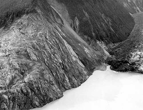
<span class=jpg Trees washed out and turned upslope by water at altitude of 1,720 feet." align="bottom" border="0" height="384" width="500">
Trees washed out and turned upslope by water at altitude of 1,720 feet. Small slides occurred on steep slope at right during the 1958 earthquake, but destruction of forest in middle and lower left part of view is due mainly to water. Lituya district, Alaska Gulf region, Alaska. Glacier Bay National Park and Preserve. Plate 7-A in U.S. Geological Survey.
Photograph courtesy U.S. Geological Survey


The weather also plays a role in the bay as it gets a large amount of precipitation - mostly rainfall. Some of the inland areas along the coast between Lituya Bay and Yakutat have had more than 300 inches of rain according to the National Weather Service and the winter and spring of 1958 was a wet one throughout Southeast Alaska. The ground in Lituya Bay - which frequently gets up to 150 inches of rain a year - was oversaturated even though it was sunny that July.

The third factor was the massive earthquakes that frequently topped 6 and 7 on Richter Scale in the area.

A final factor was the deep water - up to 800 feet - near the head of the bay. When earthquakes or other events caused landslides, they would displace large amounts of water sending it rushing toward the narrow mouth of the bay and the open ocean.

Federal geologist Don Miller was the foremost expert on Lituya Bay in the 1950s and the early 1960s. In his 1960 report, "Giant Waves in Lituya Bay Alaska." he pointed out evidence of five "giant" waves created primarily by land or glacier slides between 1853 and 1958.


<span class=jpg Lituya Bay, 1954, trimlines of the 1936 giant waves and the 1853-54 giant wave" align="bottom" border="0" height="397" width="500">
Aerial view of Lituya Bay, 1954, trimlines of the 1936 giant waves and the 1853-54 giant wave. Lateral moraines and the end moraine in the right and left foreground record a recent advance of ice to the mouth of the bay. Mount Crillon altitude 12,726 feet is the highest peak on the skyline. Lituya district, Alaska Gulf region, Alaska. September 16, 1954. Plate 3-A in U.S. Geological Survey.
Photograph courtesy U.S. Geological Survey


The 1853-54 wave was estimated at 395 feet, the 1874 wave at 80 feet, the 1899 wave at 200 feet, the 1936 wave at 490 feet and the 1958 behemoth swept trees off a hillside at more than 1,720 feet.

In addition to those giant waves, the waters of Lituya Bay had also been the site of several other disasters involving both the native Tlingit tribes and groups of American, British and French explorers and adventurers from the 1780s into the Twentieth Century, according to Philip Fradkin in his 2001 book "Wildest Alaska: Journeys of Great Peril in Lituya Bay."

Most of these involved the deadly, narrow entrance that featured tide rips and waters running up to 13 knots in either direction. Most notable was a disaster that cost French explorer Jean-Francois La Perouse more than 20 of his sailors. Fradkin also noted that Tlingit oral tradition featured several stories of "giant" waves and mass drownings in the bay.

Three Boats In the Bay

There were two commonly used anchorages near the mouth of Lituya Bay on that July night in 1958. Ulrich and his eight-year-old son "Sonny" chose to anchor about half a mile in from the mouth on the south side of the bay in place called, appropriately enough "Anchorage Cove."

Two other trolling boats, the Sunmore (with Orville and Mickey Wagner on board) and the Badger (operated by Bill and Vivian Swanson) anchored up on the opposite side of the bay, just behind the nearly mile long spit that extended most of the way across the mouth of the bay. The opening itself was less than 300 yards across and most of that water was too shallow for boats to cross. Some fishermen estimate there may less than 50 feet of open water at times.

The Ulrichs had anchored up just after 8 pm, while the other two boats - running partners who both lived in Juneau - anchored up around 9 pm.

Around 8 pm, a plane took off from near Cenotaph Island (so named after the drowning of the 20 French sailors in 1786). On board were 10 Canadians who had just returned from the first Canadian ascent of Mount Fairweather.


<span class=jpg Stump of living spruce tree broken off by the giant wave at Harbor Point, mouth of Lituya Bay" align="bottom" border="0" height="426" width="500">
Stump of living spruce tree broken off by the giant wave at Harbor Point, mouth of Lituya Bay. Brim of hat is 12 inches in diameter. Lituya district, Alaska Gulf region, Alaska. Plate 5-B in U.S. Geological Survey.
Photograph courtesy U.S. Geological Survey

"The expedition was scheduled to leave the following day, but the pilot of their Royal Canadian Air Force amphibian arrived at 6 pm that night and told them to pack immediately," Fradkin wrote in "Wildest Alaska." "He was worried about the possibility of fog and wanted to get the climbers back to Juneau that night. The climbers cursed the pilot's nervousness. They missed dinner in a hurry to pack and departed at 9 pm. Another party of climbers was due that day by boat but they had been delayedHad the two groups proceeded as planned, there would have been a total of 20 climbers camped on the shoreline that night."

Fradkin noted that the Canadian climbers weren't the only living things making a fortuitous getaway from the bay.

"As the Canadian climbers flew away, so did the nervous kittiwakes (that nested on the cliffs of Cenotaph Island)," Fradkin wrote. "The gulls ascended like so much confetti blown upward. The high intensity alarm call of thousands of birds echoed through the still bay. They passed over the Badger and splattered the boat with droppings. Some crashed into the vessel's rigging and plummeted to the deck. The Swansons were frightened."

Up and down the coast as far as Yakutat and Hoonah observers would report similar odd behavior by shore birds and other animals. Then, at approximately 10:16 pm, it happened.

"Cursing Myself For Not Moving Sooner"

The quake was later determined to be 8.3 on the earthquake scale and was centered 45 miles south of Lituya in Cross Sound. It was felt strongly as far south as Seattle and as far north as Anchorage. At Yakutat, 80 miles to the north of Lituya, three people out berry picking died instantly when a small island they were on immediately dropped more than two dozen feet under the water. Later measurements determined that a nearby mountain had risen more than 50 feet at the same time.

Overall, the earth had moved some 21 feet horizontally and 3.5 feet vertically along most of the fault line. While most earthquakes last only a few seconds, the initial length of the quake was later estimated at more than two minutes by Don Miller.

Then Lituya Bay got hit with the other shoe.

Miller - who was in Glacier Bay at the time of quake and flew to Lituya the next day - determined that less than two minutes after the initial tremor, the side of an unnamed 5,616 foot peak on the east side of Gilbert Inlet (at the head of the bay) plunged into the bay. At least 2,000 feet of rock fell.

"The noise was deafening," Fradkin wrote. "The violent impact of forty million cubic yards of rock, ice and coarse soil weighing ninety million tonswas heard 50 miles to the north. Ulrich said it sounded like an explosion."

With the first jolt, Bill Swanson tumbled out of his bunk on the Badger. He later told the Alaska Sportsman that the he could see even the highest mountains shaking. Then he saw the Lituya Glacier appear to literally rise up into the air.

"I know you can't ordinarily see that glacier from where I was anchored," he was quoted in the October, 1958 issue. "People shake their head when I tell them I saw it that night. I can't help it if they don't believe mebut I know what I saw that night."

From his vantage point, he could also see the mountainside slide away and crash towards the water. From his viewpoint on the other side of the bay, Ulrich could see the wave rise up and devastate the forested hillside.

All three boat crews had been woken up by the earthquake. But while the captains of the Badger and Edrie were transfixed by the spectacle at the head of the bay, the Wagners on the Sunmore jumped to immediate action and got their boat headed out of the bay.

It proved to be a fatal decision. Swanson reported seeing the Sunmore just about to turn out into the entrance when it was caught by the wave and flung over Harbor Point across the opening from the end of the spit. All that was found later was an oil slick marking the spot where the boat went down in deep water.

Ulrich told Alaska Sportsman that he was "petrified" by the landslide and the wave and didn't begin to act until he saw the wave, then still some 300 feet high engulf Cenotaph Island some two miles away from his boat.

"I began to move then," he said. "And I moved fast, cursing myself for not moving sooner."

" I Think We've Had It. Goodbye"

He got a life jacket on his son and started the engine. He started to pull the anchor and found it unmovable.

"The wave (then estimated at more than 75 feet high) was almost upon us and we were fastened to the bottom with a heavy chain," Ulrich said. He surmised that the quake had caused the anchor to get tangled on the bottom. He let out all his extra chain, in hopes that it would be enough to allow the boat to ride up and over the wave. Then he turned the boat into the wave and held on.


Southeast Alaska Earthquake, July 10, 1958. Wave damage on the south shore of Lituya Bay, from Harbor Point to the spur southwest of Crillon Inlet. August 9, 1958. Photos mdj01247 through mdj01261 form a sequence of fifteen photographs.
Photograph courtesy U.S. Geological Survey


"As the Edrie began her almost perpendicular ascent to the crest of the wave, the chain snapped," Ulrich said, adding that he wanted to get a message out so his wife in Pelican would eventually find out her husband and son had died. "There seemed to be no hope for survivalI grabbed the handset of my radiophone and yelled into it: 'Mayday! Mayday! This is the Edrie in in Lituya Bay. All hell has broken loose in hereI think we've had it. Goodbye.' "

But the luck that had abandoned the Wagners was still on Ulrich's side. At the top of wave, he regained enough control of his boat to hold on and steer around the debris being carried by the wave. A few seconds later, the worst had passed.

He sent out another message saying he thought they'd made it through. Immediately, other boats outside Lituya began radioing back. But, Ulrich noted, the silence from the Badger and the Sunmore was ominous.

Just about the time that Bill Swanson saw the wave engulf the Sunmore as it tried to escape, the wave - estimated to be approximately 80 feet high - hit his boat and carried it over the La Chaussee Spit and dumped it stern first into the open ocean.

"We went way over the trees and I looked down on rocks as big as an ordinary house as we crossed the spit," Swanson told the Alaska Sportsman. "We were way up above them. It felt like we were in a tin can and somebody was shaking it."

After the crash landing, the boat immediately began to sink. They were surrounded by acres of wood debris - including a large tree that smashed through the pilot house and broke several of Swanson's ribs - but managed to get into eight foot skiff with only their underclothes on, according to Fradkin's book. At nearly midnight, they were found by the crew of the vessel Lumen which was picking its way through the miles of debris looking for signs of survivors in the pitch dark.

After surviving the giant Lituya wave, Ulrich continued to fish but then quit the business a year later. As recently as 2004, he was still reliving the events of July 9, 1958. He wrote a brief story that appeared in Esquire magazine about that night under the title "What it Feels Like to Survive a Tsunami."

The Swansons eventually got a replacement boat, but Vivian - whose hair reportedly turned gray overnight after the Lituya incident - refused to go fishing with Bill again, according to Fradkin.

On the night of May 26, 1962. Bill Swanson returned to Lituya Bay for the first time since the wave in 1958. Shortly after passing through the narrow entrance to the bay, he suffered a massive heart attack and died.


WEATHER NOTE

LATEST ON FAY


Web makes it easy for stormchasers to track weather
ROBERT NOLIN

In ancient times, before the Internet ruled the world, folks needed pencil, straightedge and a rudimentary knowledge of latitude and longitude to track a storm like the wannabe tropical depression now knocking at the Caribbean's door.

No longer.

Now all an amateur storm chaser needs is a keyboard and mouse. In recent years, meteorological-based Web sites, including that of the U.S. government's own National Hurricane Center, have become sophisticated enough to drench even the most demanding weather buff with information.

"They've improved, they're faster, they have more information," said Scott Weiner, 41, who flicks on the computer when he hankers to follow a storm's progress. "The first place I go is the (South Florida) Sun Sentinel."

This newspaper's hurricane-related Web fixture, sunsentinel.com/hurricane, offers real-time storm tracking, a weather blog, satellite maps, storm histories and other features.

With an average of 38 million page views a month, the Weather Channel's Web site, weather.com, leads the pack in terms of popularity, according to Nielsen/NetRating. Users charting a storm don't want to wait for broadcast reports, site spokeswoman Melissa Medori said.

"I guess it's the usage pattern of 'I want it now. I don't want to have to wait for the next update,'" she said.

Rapid, frequent updates are indeed the draw for Weiner, as are fancy graphics and blogs. "I want to look at the maps, the projections," he said. "TV weather is useless."

If a storm is thrashing around the neighborhood, visits to weather Web sites spike.

"When there's any tropical storm or hurricane threatening land, especially U.S. soil, our traffic goes up approximately 50 percent," said Toby Skinner of The Weather Underground, the second-most popular site. "We talking such huge numbers we have to make plans to make sure our whole system doesn't break down."

Last month, when Hurricane Dolly barreled toward Texas, about 22 million visited wunderground.com in one day, Skinner said. "It's even more than we had with Katrina," he added, referring to the 2005 hurricane that wrecked New Orleans. "We're showing gradual increases year upon year."

Weather Web sites all use the same material from the National Hurricane Center in Miami-Dade County, but they customize maps, computer model tracks and snazzy graphics to enthrall viewers. Weather.com tosses in raw storm videos, photos and pet pictures. Another site, skeetobiteweather.com, prides itself on a more businesslike presentation.

The hurricane center has jazzed up its own site Web site to make it more layperson-friendly, said spokesman Dennis Feltgen. "We're in the 21st Century, we've got high-resolution graphics, we've taken the text piece and basically made it graphical."

The result, he said, has drawn 4 million page clicks to the site so far this year - not bad for a government venue. "They're clearly seeking the information out and they're quite savvy," Feltgen said of the mouse-wielding public.

But he cautioned that big decisions, such as when to shutter up or evacuate, should be left to professionals, and not armchair prognosticators.

"We certainly would not encourage them to make their own interpretation of track forecasts and intensity forecasts," he said. "We've got a number of scientists here at the center and that's what they're trained to do."

Hurricanes and climate change: A sharper view

August 13, 2008

In a study published in the July 2008 issue of Geophysical Research Letters, Drs. David S. Nolan and Eric D. Rappin from the University of Miami's Rosenstiel School of Marine and Atmospheric Science describe a new method for evaluating the frequency of hurricane formation in present and future tropical climates. While current thinking about changes in hurricane frequency comes mostly from computer simulations of global climate, the computer models used for these studies can only represent the coarsest features of hurricanes, thus casting doubt in their predictions of hurricane activity.

The new approach by Nolan and Rappin, developed in collaboration with Dr. Kerry Emanuel of the Massachusetts Institute of Technology, uses computer models with much more accurate representation of the processes that lead to hurricane formation, much the same way a digital image with more pixels allows for a more detailed photographic image. The models are used to simulate the rate of hurricane development in tropical atmospheres with varying values of sea surface temperature and vertical wind shear (which is the extent to which wind speed and direction changes with height in the atmosphere). These two variables - ocean temperature and wind shear -- are considered to be the two most important factors in predicting hurricane activity, both in operational forecasting and in consideration of climate change.

MARITIME NOTE

Riverdance ferry - a sorry sight


These pictures by Gazette photographer Bill Johnson show the pitiful remains of the wrecked Riverdance ferry – seven months after it ran aground off the Cleveleys coast.

What began as a huge tourist attraction – the sight of the beached vessel has brought thousands of trippers to the seafront – now looks more like a rusted shed as demolition teams have reduced it to a sorry sight.

Both engines have been removed from the 6,000 tonne ship and carted off to a spares company in the North East of England.

More than 34,000 litres of oil had to be taken off the stricken cargo ferry and other potential marine pollutants have also been removed. It will not be long before the wreck – which has been photographed by visitors from across the world since it became beached in heavy seas on January 31 – is completely removed.

Demolition experts from Hancock's Contractors Ltd and PGC Demolition Ltd have been working over the last two months to dismantle the ship piece by piece.

But it is painstaking and difficult work – depending on the weather and tidal patterns.

Fred Caygill, from the Maritime and Coastguard Agency, said: "The vessel has been stripped down internally, it's only the shell that remains.

"Sections are being cut off and the pieces being transported for recycling.

"The teams are making good progress and have done meticulous work.

"There is not a lot left of the ship now. All the work has been done without any loss or damage to the local environment.

"The work still remains on schedule, but we cannot give an exact completion date because it depends on the tides and the weather.

"But we are expecting the work to be completed around the end of September to early October."


RS

Wednesday, August 13, 2008

High Arctic surveillance study hampered by strong winds

High Arctic surveillance study hampered by strong winds

Inclement weather is creating delays for Canadian defence scientists trying to test surveillance devices in the High Arctic this week.

A 10-person team with National Defence is on Devon Island, trying to install land-based sensors there and underwater listening devices stretching out into Barrow Strait, as part of its four-year Northern Watch pilot research project.

But winds gusting up to 90 km/h in the area are hampering the research team's efforts to install the devices, which requires use of a helicopter, Twin Otter airplanes and all-terrain vehicles.

"We've been successful at setting up the basic camp, but now we're on standby and waiting for better weather conditions," Roger Dao, the Northern Watch project manager with Defence Research and Development Canada, told CBC News on Thursday.

"It's been a challenge. People need to bend over because the winds are really moving, pushing them around," he added with a laugh.

The Northern Watch project is aimed at boosting Canada's ability to keep an eye on ships and submarines passing through the eastern entrance to the Northwest Passage.

Dao said his team has installed the satellite link, so they have communications from the base.

The coast guard ship Terry Fox is waiting for the weather to clear so it can help the researchers install an underwater cable out into Barrow Strait.

The team is supposed to be in the High Arctic for two weeks, but Dao said they may extend their stay and try to get more work done.

Keeping an eye for 'rogue' vessels

Grise Fiord resident and Arctic sovereignty watcher Larry Audlaluk said he's glad Canada is moving ahead with the Northern Watch project, especially given all the cruise ships and other vessels coming into the North.

"I think it's a very good idea, keeping an eye on who's coming, what foreigners are coming, and to keep an eye on any rogue ships or submarines that are not friendly, as they say, in military terms," Audlaluk said.

Still, Audlaluk added that the federal government should give northerners more information about their efforts, so residents know what's going on.

National Defence says it plans to get the Canadian Rangers involved with the project, as well as hire locals for jobs at the base camp.

Dao said the lessons they learn this summer will be useful for the next three years of the Northern Watch project.

WEATHER NOTE

Regional Hurricane Shelter Step Closer

Published: June 24, 2008

NEW PORT RICHEY - NEW PORT RICHEY - Plans are moving forward for a regional hurricane shelter and health care clinic in Hudson.

The county commission at a meeting today in New Port Richey awarded a $7.5 million contract to Spring Engineering and Bandes Construction to design and build the facility off Denton Avenue. The project is being funded with state and federal grants.

According to the terms of the agreement, the shelter must comply with the latest federal standards, to withstand winds up to 200 miles per hour and the pressures of an F5 tornado.
The Federal Emergency Management Agency has, however, exempted the facility from the more stringent rules, Assistant County Attorney Jane Fagan said, and the cost of construction may decrease in light of the exemption.

The shelter still must withstand 190 mph winds, but the exemption will allow for significant savings, county officials have said.

An additional $750,000 has been allocated to convert the shelter into a clinic for uninsured and underinsured residents.

Also Tuesday, the West Pasco Chamber of Commerce asked the board to renew its sponsorship of Business Development Week in January.

In the past, the county has been a major sponsor, contributing $15,000 to the weeklong event.
Commissioners delayed consideration of the item until next month, when they begin the arduous process of cutting some $22 million from the $1.2 billion county budget. The cuts are needed to compensate for a constitutional amendment allowing bigger property tax breaks for homeowners and to make up for reductions in state funding.

Chamber President Joe Alpine said his organization understands the county's financial constraints and hopes for some kind of contribution. This past January, more than 1,000 people participated in Business Development Week.

"We do know it's hard economic times right now," Alpine said. "No matter what the decision is, we intend to move forward with our workshops. It's very important for businesses to get good skills and experience they need to operate efficiently. Much hinges on the success of businesses."
Commissioner Jack Mariano suggested the chamber look to outside funding sources in case the county commission can't contribute.

Commission Chairman Ted Schrader asked if there were other levels of sponsorship.
Alpine said the county could contribute $7,500 and still be a leading sponsor.

Maritime Note

My good friend at Freague Waves has a excellent article on the KAZ II

Sunday, August 10, 2008
The case of Yacht Kaz II

I blogged about the case of yacht Kaz II as part of a post entitled "Peril of yachting in the South Ocean" last year. Kaz II has been branded as a ghost ship ever since she was found on April 18, 2007 while drifting with engine running but no crew on board. TimesOnline reported a week later that pthe three men crew "were most like washed overboard in a violent squall or freak wave according to police" among other possible explanations.

Well, there was a "coronial' inquiry being conducted last week and this morning the Guardian reported the coroner's ruling. First a recap of the case:

The trio, described as "typical Aussie blokes", vanished after setting sail on April 15 last year on a planned two-month trip, bound for Western Australia where they all lived. Three days later, the white-painted vessel which Mr Batten had only recently bought for £60,000 was found adrift and with a ripped sail about 100 miles north-east of Townsville, near the Whitsunday islands.

The engine was idling, a half-empty cup of coffee and a laptop computer were sitting on a table, a newspaper was lying open with some pages strewn on the floor and clothing had been piled on a bench.

The men went to sea with a large supply of food, three cases of beer, a .44 calibre rifle and 100 rounds of ammunition, the inquest was told.

Now the finding:

Coroner Michael Barnes said evidence put before him during a four day inquest led him to conclude that "an unfortunate series of events," befell the trio, who were all relatively inexperienced sailors, only a few hours after they set sail.

In the scenario he laid out, the coroner said one of the brothers attempted to free a fishing line that had become wrapped around the yacht's propeller when he fell overboard. The other brother fell in while trying to rescue him.

Mr Batten tried to drop the sails so he could turn around and go back for his two friends but a change in the wind's direction caused the yacht's boom to swing and knock him overboard.

"Once the three men were in the water there was very little chance they could get back on the boat," he said. "It would be beyond their reach in seconds. From that point, the end would have been swift.

"None of them was a good swimmer, the seas were choppy, they would have quickly become exhausted and sunk beneath the waves. Although I can't exclude the possibility of a shark attacking them, drowning is a far more likely cause of death."

which is a very plausible scenario. I am impressed. I guess an important piece of evidence which might not have made public before was shown to the court, in which the skipper, Des Batten, was holding the camera and

Jim Tunstead can be seen fishing while he and Mr Batten are heard mocking Peter Tunstead, a non-swimmer, who was sitting fishing at the back with the safety rail down. He was not wearing a lifejacket. In the film, the men talk about "threatening skies" ahead.

That seems to be a logical scene that led to the scenario the coroner concluded. They were not good swimmers and they did not bother to wear their lifejacket should also be an important lesson for everyone to learn here.

The seas were choppy, we can not preclude the possible occurrence of a freaque wave. But whether or not a freaque wave occurred, it will not alter in any way the scenario the coroner so brilliantly laid out.

They still have not been able to find their bodies. But at least their yacht, the Kaz II, is no longer a ghost boat.

RS

Monday, July 7, 2008

Extreme Ocean Storms Have Become More Frequent Over Past Three Decades, Study Of Tiny Tremors Shows

Extreme Ocean Storms Have Become More Frequent Over Past Three Decades, Study Of Tiny Tremors Shows

ScienceDaily (Apr. 21, 2008)
—Data from faint earth tremors caused by wind-driven ocean waves -- often dismissed as "background noise" at seismographic stations around the world -- suggest extreme ocean storms have become more frequent over the past three decades. The International Panel on Climate Change (IPCC) and other prominent researchers have predicted that stronger and more frequent storms may occur as a result of global warming trends. The tiny tremors, or microseisms, offer a new way to discover whether these predictions are already coming true, said Richard Aster, a geophysics professor at the New Mexico Institute of Mining and Technology.

Unceasing as the ocean waves that trigger them, the microseisms show up as five- to 30-second oscillations of Earth's surface at seismographic stations around the world. Even seismic monitoring stations "in the middle of a continent are sensitive to the waves crashing all around the continent," Aster said.

As storm winds drive ocean waves higher, the microseism signals increase their amplitude as well, offering a unique way to track storm intensities across seasons, over time, and at different geographical locations. For instance, Aster and colleagues Daniel McNamara from the U.S. Geological Survey and Peter Bromirski of the Scripps Institution of Oceanography recently published analysis in the Seismological Society of America journal Seismological Research Letters showing that microseism data collected around the Pacific Basin and throughout the world could be used to detect and quantify wave activity from multi-year events such as the El Niño and La Niña ocean disruptions.

The findings spurred them to look for a microseism signal that would reveal whether extreme storms were becoming more common in a warming world. In fact, they saw "a remarkable thing," among the worldwide microseism data collected from 1972 to 2008, Aster recalled. In 22 of the 22 stations included in the study, the number of extreme storm events had increased over time, they found.

While the work on evaluating changes in extreme storms is "still very much in its early stages", Aster is "hoping that the study will offer a much more global look" at the effects of climate change on extreme storms and the wind-driven waves that they produce. At the moment, most of the evidence linking the two comes from studies of hurricane intensity and shoreline erosion in specific regions such as the Pacific Northwest Gulf of Mexico, he noted.

The researchers are also working on recovering and digitizing older microseism records, potentially creating a data set that stretches back to the 1930s. Aster praised the work of the long-term observatories that have collected the records, calling them a good example of the "Cinderella science"--unloved and overlooked--that often support significant discoveries.

"It's absolutely great data on the state of the planet. We took a prosaic time series, and found something very interesting in it," he said.

WEATHER NOTE

FEMA plans evacuation exercise in New Orleans

NEW ORLEANS -- State and federal officials have scheduled an evacuation exercise next month in Louisiana as they prepare for the 2008 hurricane season.

The July 9 exercise for Orleans, St. Barnard, Plaquemines, Jefferson, St. Charles and St. John the Baptist parishes will test the ability of cities and parishes to register and transport people to shelters, according to a news release from the Federal Emergency Management Agency."FEMA is working closely with parish and state officials to provide what they need to evacuate anyone who needs help leaving. We're focusing on the elderly, hospital and nursing home residents and those who have no other transportation available to them," Michael Hall, who's leading FEMA's preparedness activities in Louisiana, said in the release.Mark Cooper, director of Louisiana's Homeland Security and Emergency Preparedness office, said the state Department of Transportation and Development has signed contracts for 700 motor coaches to move those who are fleeing an approaching storm like Hurricane Katrina, which devastated the city and the Gulf Coast in 2005.

In addition to the state's bus contract, FEMA recently signed a national contract with AMTRAK to provide passenger trains to help move critical needs residents out of the area when an evacuation is ordered.The July exercise will test bus and rail resources, along with the role the Louis Armstrong International Airport will play.


Geospatial Intelligence and Imagery Aid in Midwest Flood Response

WASHINGTON, D.C. --The National Geospatial-Intelligence Agency (NGA) is working with the Federal Emergency Management Agency (FEMA) to support flood response efforts in the Midwest.

NGA is providing analysis, unclassified commercial imagery of flooded areas and geospatial intelligence products to FEMA and emergency responders in the affected areas to aid in rescue and recovery efforts. The products include graphics of major infrastructure, such as the location of airports, hospitals, police and fire stations, emergency operations centers, hazardous material locations, highways and schools.

FEMA, state and local responders use the products to aid in damage assessments, estimate housing needs, position supplies and other resources and coordinate relief efforts. The graphics also provide a common operating picture that helps enable local, state and federal officials work together more effectively and efficiently.

Through the NGA's crisis response portal, the public has access to some of the images, allowing property owners to broadly assess property damage without having to physically visit the area. NGA established its Earth site in 2005 after realizing victims of Hurricane Katrina could use commercial geospatial imagery to check damage to their property along the Gulf Coast.

The NGA Earth site uses the Internet to provide emergency responders and the public a single, easy-to-use entry point for locating timely, relevant, unclassified geospatial information in the event of a disaster or crisis. The NGA Earth site (http://www.nga-earth.org/) is updated as new images are made available. In addition to the images hosted at this location, the site provides links to other federal agency sites and is an access point to leverage other NGA geospatial expertise and products.

NGA's mission is to provide timely, relevant and accurate geospatial intelligence in support of the nation. The term "geospatial intelligence" means the exploitation and analysis of imagery and geospatial information to describe, assess and visually depict physical features and geographically referenced activities on the Earth.

FEMA coordinates the federal government's role in preparing for, preventing, mitigating the effects of, responding to, and recovering from all domestic disasters, whether natural or man-made, including acts of terror.

MARITIME NOTE

Ship’s insurance limited

THE GOVERNMENT DOES NOT HAVE MUCH CHOICE BUT to take over the salvage operations for the sunken MV Princess of the Stars because the vessel’s insurance coverage is limited to passengers and cargo and does not extend to ship damage, Sen. Manuel Roxas said.

Roxas said the government should act fast to prevent the shipwreck from causing any more damage to the environment because of its dangerous cargo of fuel and pesticide.

It should not wait any more for the shipowner, Sulpicio Lines, to take action, the senator said.

Roxas said that while Sulpicio was not compelled to purchase such insurance under the law because it was mainly a passenger and not a cargo liner, it should have obtained the insurance out of prudence considering its long history of disasters dating back to the sinking of the MV Doña Paz in 1987, considered the worst civilian maritime disaster in history in terms of lives lost (more than 4,000).

The senator said this could be the reason why it was taking Sulpicio such a long time to salvage its sunken ship. He recalled the well-funded salvage operations for the capsized Solar I that caused the Guimaras oil spill in 2006.

“This is one of the regulation loopholes that we hope to plug in the Senate investigation,” said Roxas.

The Oriental Assurance Corp., Sulpicio’s insurer, said the estimated 800 people on board the Princess of the Stars were covered by an accident insurance policy with the firm.

“Yes, passengers of Sulpicio Lines are insured by us, and we guarantee the payment of claims,” said Luz Cotoco, executive vice president of Oriental Assurance.

She said Oriental Assurance was financially healthy and capable of servicing all claims.

Cotoco declined to give the amount of insurance coverage for each passenger, saying Sulpicio Lines has asked that all insurance-related queries be directed to the shipping company.

An industry source said, however, that Oriental Assurance would pay P200,000 per passenger, or a total of about P160 million, to cover the estimated 800 people on board the sunken ship.

The source said Sulpicio Lines also has a P350-million marine hull insurance policy with Oriental Assurance that covers the cost of the ship.

But the owner of a rival shipping firm said that insuring the passengers and the vessel was not enough.

He said Sulpicio should have gotten, aside from accident insurance coverage for its passengers, a protective and indemnity insurance (P&I).

All responsible shipping firms know that getting P&I is absolutely necessary in the shipping business, the source said.

P&I is a form of a third-party liability insurance. It covers the cost of cleaning up possible oil spills and messes resulting from a shipwreck. P&I also covers the cost of the damage when a ship collides with another, or causes damage to other assets.

P&I is like the CTPL [comprehensive third-party liability] for cars, the rival shipowner said.

He said Sulpicio tried but failed to get P&I coverage three years ago, because no insurance company wanted to provide cover, knowing that Sulpicio’s ships were not in perfect condition.

Oriental Assurance said Sulpicio did not have a P&I policy with the firm.

Denis Cabucos, chief of the licensing division of the Insurance Commission, said he knew that Sulpicio has accident insurance coverage for its passengers but was not aware if it had P&I coverage.

Cabucos explained that insurance companies are not required to provide the Insurance Commission with a list of their policy holders.

But he said the commission would act on any insurance-related complaints received by its public assistance division.

Vicente Suazo, administrator of the Maritime Industry Authority, confirmed that Sulpicio did not have P&I insurance. But he said P&I coverage was not required by law.

“What is more important is accident insurance coverage for passengers. That is the one required by law [Republic Act No. 9295],” Suazo said in a phone interview.

He said it was arguable whether P&I was indispensable for shipping companies, but Sulpico Lines did not break the law by not having one.


RS