Showing posts with label chicago severe weather. Show all posts

Friday, January 16, 2009

UPDATE -Dangerous Wind Chills Through Friday Morning

Dangerous Wind Chills Through Friday Morning

NWS CHICAGO (KLOT)

A wind chill warning remains in effect for all of northern Illinois and northwest Indiana through Friday morning for very dangerous wind chills of 25 below to 40 below.

Some improvement is expected by Friday afternoon as air temperatures warm above zero. Please refer to the following for the latest information on the wind chill warning.

FORECAST AND WARNING INFORMATION -----------------------

Wind Chill Warning information
NWS Chicago Winter Weather Page

CURRENT CONDITIONS ---------------------------------------------------

Illinois Current Wind Chill Values, Temperatures, and Wind Speeds
Indiana Current Wind Chill Values, Temperatures, and Wind Speeds

REFERENCES ---------------------------------------------------------------

Winter Weather Definitions:

Wind Chill Warning - Extreme wind chills of -30oF or colder.A Wind Chill Warning is issued when the wind chill will be less than or equal to -30oF AND winds greater than or equal to 10 mph.

Wind Chill Advisory - Dangerous wind chills of -20oF to -30oF.A Wind Chill Advisory will be issued when the wind chill is less than or equal to -20oF AND the winds are greater than or equal to 10 mph.

Wind Chill Temperature Chart Click here for a Wind Chill Calculator

Additional References
COLD WEATHER ISSUES
COLD WEATHER SURVIVAL
Extreme Cold: A Prevention Guide to Promote Your Personal Health and Safety
Cold Weather Survival Guide - History.com
Key to battling cold: Dress warmly, experts say
Preparation key, say residents of chilliest cities


City Of Chicago
City of Chicago Warming and Cooling Centers
Where to Go for Safety in Extreme Heat or Cold


During extreme cold or hot weather, the City of Chicago offers these six warming and cooling centers. Call 311 to learn more or to schedule free transportation to the centers.

Need Transportation? CALL 3-1-1!

North Area Center
4740 North Sheridan Rd.
Chicago, IL 60640
312-744-2580

Trina Davila Center
4345-47 West Armitage Ave.
Chicago, IL 60639
312-744-2014

Garfield Center
10 S. Kedzie Ave.
Chicago, IL 60612
312-746-5400

King Center
4314 South Cottage Grove Ave.
Chicago, IL 60653
312-747-2300

Englewood Center
845 W. 69th St.
Chicago, IL 60621
312-747-0200

South Chicago Center
8759 S. Commercial Ave.
Chicago, IL 60617
312-747-0331

Keep posted to the NWS CHICAGO (KLOT) website for updates on this very dangerous weather condition.

RS

Tuesday, September 16, 2008

Hurricane Ike Impact Felt In Space

Hurricane Ike Impact Felt In Space

ScienceDaily (Sep. 12, 2008) Hurricane Ike has delayed the scheduled Friday arrival of a Russian Progress cargo ship at the International Space Station 220 miles above Earth.

The Progress docking was postponed when the space station's control room at NASA's Johnson Space Center in Houston was closed Thursday because of the approaching storm.

Control of the space station was handed to flight controllers at backup facilities near Austin, Texas, and Huntsville, Ala. Because the Mission Control Center in Houston is responsible for commanding many of the station's systems, U.S. and Russian officials agreed to delay the docking.

Russian flight controllers will execute a maneuver to place the Progress spacecraft into a safe orbit away from the station until docking, which is planned for Wednesday, Sept. 17. If Johnson's control center is not restored to full capability for docking, one of the backup facilities may be used to command the station's systems.

Station Commander Sergei Volkov and Flight Engineers Oleg Kononenko and Greg Chamitoff are awaiting the arrival of the cargo ship. The spacecraft is carrying more than 2 tons of supplies, including food and fuel.

Hurricane Ike Spurs 2,000 Rescues; Thousands More Await

When Hurricane Ike blasted the U.S. Gulf Coast on Saturday, an estimated 140,000 Texas residents refused to evacuate when ordered to do so.

Now 1,984 of these people have been rescued so far in Texas, including 394 by air, authorities said at a news conference Sunday afternoon. A door-to-door search continues in Galveston, where Ike came ashore early Saturday.

(See Hurricane Ike photos.)

Officials are urging all residents of Galveston to stay away from the barrier island, telling them there is no way to live there right now. It could take up to a month to restore power, and roads are still flooded. (VIDEO: Hurricane Ike Devastation.)

Crews navigated debris-strewn streets to reach people still stuck in some of the thousands of homes flooded by the hurricane. Authorities imposed a curfew in Houston and warned it would be weeks before the nation's fourth largest city is fully back up and running.

Heavy morning rains hampered rescue efforts in the hardest-hit areas of the Texas and Louisiana coasts. Meanwhile, residents who had evacuated and tried to return to the Houston area found interstates and streets blocked by flooding and debris.

Authorities hoped to spare thousands of Texans from another night amid the destruction. Eight deaths have been blamed on the storm, and authorities are worried the toll could rise.

"I'm worried about my mother's medical condition. We haven't been able to get to anyone at the clinic on the phone," said Zee Ellis, whose mother, 80-year-old Ruth Willis, fled Houston with her family ahead of the storm.

As they waited out a downpour along Interstate 10 on Sunday morning, Ellis said her mother's cancer treatments had been interrupted as they had moved from place to place, looking for shelter and electricity.

U.S. President George W. Bush planned to travel to Texas on Tuesday to express sympathy and lend support to the storm's victims. He asked people who evacuated before the hurricane to listen to local authorities before trying to return home.

In Houston a weeklong curfew from 9 p.m. to 6 a.m. has been imposed, because most of the city is still without power. Highways, darkened streetlights, and pooled water make it difficult to drive.

"In the interest of safety, we're asking people to not be out in the streets in their vehicles or on foot," the Houston police chief, Harold Hurtt, said.

In Hackberry, Louisiana, about 15 miles (24 kilometers) from the coast, workers moved a large shrimp boat out of the highway with a bulldozer. But the team had to stop because of strong currents in the floodwaters and difficulty in seeing the roadway.

"You can't see the sides of the road, and if you left the road, you'd just be swept away," National Guard spokesperson Sgt. Rebekah Malone said. About 20 people have been evacuated by boat in Hackberry.

Residents of the tiny community of Seabrook, Texas, near NASA's Johnson Space Center, were met by a roadblock as they tried to return home, and police officers standing in the rain turned them away. At times the line was 6 to 12 cars deep.

"It's going to be a while," an officer shouted to one man as he made a U-turn. "Just listen to the news."

"Seabrook is a disaster area: no sewer, no infrastructure. It really isn't safe," said officer Charlie Skinner. "It's making residents pretty upset. I understand, but … There's an order signed by the mayor. We can't let anybody in."

Overnight, a team of paramedics, rescue dogs, and structural engineers fanned out under a nearly full moon on a finger of land in Galveston Bay. To the northeast, Coast Guard crews also worked into early Sunday morning, pulling a half dozen people out of Bridge City before rescue missions were suspended for the night.

Five-year-old Jack King escaped serious injury when a rush of storm-surge water washed out the first floor of his family's Galveston home just two blocks from the bay.

"I falled in the attic," the boy told paramedic Stanley Hempstead of his ten-foot (three-meter) tumble through the attic and onto the garage floor.

Jack and his family rode out the storm with blankets and other supplies. As the Texas Task Force 1 Search and Rescue crew arrived, Jack gazed at a TV aglow with The Simpsons, a Band-Aid covering a gash on his head.

"We just didn't think it was going to come up like this," said the boy's father, Lee King. "I'm from New Orleans, I know better. I just didn't think it was going to happen."

On one side of the Galveston peninsula, two barges had broken loose and smashed into homes. Everything from red vinyl barstools to clay roof tiles litters the landscape.

The second floors of some homes sit where the first floors were before Ike's surge washed them out, and only frames remain below the roofs of others, opening a clear view from front yard to back.

Eight deaths have been blamed on the storm—five in Texas, two in Louisiana and one in Arkansas. Authorities said Sunday three people have been found dead in Galveston, including one person found in a submerged vehicle near the airport. Another person died in Arkansas when a tree fell on his mobile home as the remnants swept through.

Texas Governor Rick Perry's office said 940 people had been saved by nightfall Saturday but that thousands had made distress calls the night before. Another 600 have been rescued from flooding in Louisiana.

In Orange, Texas, Mayor Brown Claybar estimated about a third of the city of 19,000 people was flooded, from 6 inches (15 centimeters) of water to 6 feet (183 centimeters). He said about 375 people who stayed behind during the storm had begun to emerge, some needing food, water, and medical care.

"These people got out with the wet shirts on their back," Claybar said. He said he did not know how many were still stranded. He didn't know exactly how long it would take to pump water out of the city.

Hurricane Ike was the first major storm to directly hit a major U.S. metro area since Hurricane Katrina devastated New Orleans in 2005.

Ike weakened to a tropical depression early Sunday morning but was still packing winds up to 35 miles (56 kilometers) as it dumped rain over Arkansas and traveled across Missouri. Tornado-warning sirens sounded Saturday in parts of Arkansas, and the storm downed trees and knocked out power to thousands there.

More than three million people were without power in Texas at the height of the storm, and it could be weeks before electric service is fully restored. Utilities had made some progress by late Saturday, and lights had returned to parts of Houston.

In Louisiana, battered by both Ike and Labor Day's Hurricane Gustav, 180,000 homes and businesses were in the dark.

Those residents who did leave were glad they had heeded orders, despite the inconvenience. Retired nurse Ida Mayfield said that, because Gustav hit Louisiana and not Beaumont two weeks ago, many people had decided not to evacuate ahead of Ike. She was warm and dry at a church-turned-shelter in Tyler, along with thousands of her neighbors.

"Two o'clock this morning made a believer out of all of them," said the 52-year-old Mayfield, adding that she spoke to a friend Saturday who was on a roof waiting for help after calling 911. "They're scared now."

Associated Press Writers Pauline Arrillaga in Houston, Jay Root and Kelley Shannon in Austin, Doug Simpson in Baton Rouge, April Castro, Mark Williams and Andre Coe in College Station, Allen G. Breed in Surfside Beach, Juan Lozano in Orange, Elizabeth White in San Antonio and Michael Kunzelman contributed to this report.


HURRICANE BASICS


IKE AND CHICAGO!

KLOT - September 13th to 14th Flooding Event

A tropical air mass set up across northern Illinois and northwest Indiana which led to a large portion of the region ending up with substantial flooding. The heaviest rain began early on Saturday the 13th and lasted through most of the day, with a brief period in the evening where rain finally ceased. Rainfall amounts were generally in the 4 to 8 inch range across the hardest hit areas, which spans across most of northeast Illinois and northwest Indiana. Numerous streets and highways have shut down because of the heavy rain along with basement flooding. The large swath of heavy rain has also caused most rivers in the region to climb into flood stage, with major to record flooding forecast on some rivers. Additionally, the 6.64 inches of rain that fell at O’Hare International Airport on the 13th established a new all time record calendar day rainfall for Chicago, where records date back to 1871. The previous record was on August 14, 1987 when 6.49 inches fell. The following is a map plotting out all of the Flood or Flash Flood reports received by the National Weather Service in Romeoville from Saturday morning through Saturday evening as well as the radar estimate of the event from Friday evening (when rainfall was light) through Sunday morning.

Flood Reports from September 13th/14th

Flood reports from September 13th to 14th

NWS Chicago Radar estimate of rainfall from Friday evening to Sunday morning

NWS Chicago Doppler radar estimate of rainfall from Friday evening into Sunday morning. Green shading indicates 1 to 2.5 inches, yellow shading indicates 2.5 to 5 inches, while red shading indicates 5 to 10 inches of rain.

Unfortunately, the rainfall is not over. The tropical remnants of what was Hurricane Ike are moving northeastward into the region and combined with a cold front trying to push through has led to the redevelopment of light to moderate rainfall. As the remnants of Ike reach the Chicago area later this morning, the rainfall is expected to intensify with additional amounts of 1 to 2 inches with locally higher amounts of 4 inches by this evening. With most areas still having standing water and rivers stressed to their limits, any additional rainfall is going to make conditions worse.

Residents of northeast Illinois and northwest Indiana are asked to take caution and beware of flooded roadways. With the amount of roads that have been closed due to flooding, some municipalities have run out of signs to mark roadways that are flooded. Take particular caution if you are driving at night as a flooded roadway may not be noticeable until you are upon it. As always, it is very difficult to judge how deep the standing or flowing water over a roadway may be, so turn around and don’t drown!

Here are a few helpful links to monitor the flooding…

Additional information can always be found on NWS Chicago’s website at weather.gov/chicago

Rainfall Totals From the Storm September 12-14 2008!

Here are the storm total precipitation amounts from our Cooperative Observers as well as our CoCoRaHs observers across Northern Illinois and Northwest Indiana. It covers the period from 7 am Friday, September 12 through 7 am Monday, September 15, 2008. The table below is listed from highest to lowest amounts. If you would like to see the list by county, click here.

Thank you to all our volunteers who reported during this rain event!

Station ID Name
3 day total
IN-PT-64 VALPARAISO 1.4 ENE
11.02
IN-PT-32 PORTAGE 0.9 ESE
10.74
IN-PT-69 PORTER 0.6 S
10.69
IN-PT-34 CHESTERTON 1.7 WSW
10.59
IL-DP-53 WHEATON 1.7 N
10.53
ELBI2 ELBURN
10.51
IL-KN-30 ELBURN 0.4 NW
10.51
IN-PT-60 LAKES OF THE FOUR SEASONS
10.41
IN-PT-8 VALPARAISO 0.6 SE
10.33
IL-CK-107 EVANSTON 1.4 N
10.20
IN-PT-27 KOUTS 2.8 N
10.16
IN-PT-62 VALPARAISO 7.4 WSW
10.09
IL-CK-69 PARK FOREST 0.8 NNE
10.01
IN-LK-6 CROWN POINT 6.6 ESE
9.94
IN-PT-1 VALPARAISO 3.9 NNW
9.87
IN-LP-14 MICHIGAN CITY 1.3 SSW
9.79
IL-CK-84 BARTLETT 1.2 NE
9.78
IN-PT-13 VALPARAISO 6.2 WSW
9.74
IN-PT-30 VALPARAISO 5.8 WSW
9.67
IN-LK-31 MERRILLVILLE 0.8 NNW
9.37
IL-CK-46 DES PLAINES 0.5 NW
9.36
IN-PT-19 VALPARAISO 5.9 NW
9.22
SCKI2 ST CHARLES 7 NW
9.18
PAWI2 PAW PAW
9.16
IL-KN-8 GENEVA 3.3 WSW
9.15
IL-KN-58 LILY LAKE 2.1 E
9.13
IN-PT-43 CHESTERTON 2.3 ESE
9.13
SCHI2 ST CHARLES
9.10
IL-KN-68 GENEVA 0.9 N
9.09
IN-PT-12 VALPARAISO 4.3 SW
9.09
IL-KN-64 ST CHARLES 0.1 E
9.08
IN-LK-26 CROWN POINT 1.1 N
9.04
IL-KN-66 GENEVA 1.0 E
9.03
IL-DP-34 WEST CHICAGO 2.7 N
9.02
IL-CK-75 ELK GROVE VILLAGE 2.2 WSW
8.95
IN-LK-8 HAMMOND 3.0 SW
8.95
IN-PT-44 CROWN POINT 7.6 ESE
8.90
IL-CK-64 HOMEWOOD 0.1 ESE
8.89
IL-KN-31 ST CHARLES 1.6 SW
8.83
IN-PT-14 CHESTERTON 3.0 ESE
8.77
IL-CK-76 FLOSSMOOR 1.1 ESE
8.76
IN-PT-25 VALPARAISO 5.1 WSW
8.76
IL-CK-63 ELK GROVE VILLAGE 0.6 ESE
8.74
IL-DP-61 ROSELLE 0.5 S
8.61
STAI2 STREATOR
8.55
IL-WL-25 CRETE 2.6 E
8.55
IN-LK-24 CROWN POINT 2.0 WSW
8.55
IL-KN-63 GENEVA 1.7 WSW
8.54
IL-KN-1 GENEVA 1.6 ENE
8.52
IL-DP-42 CAROL STREAM 0.3 SSE
8.51
IL-CK-18 SKOKIE 1.0 NNE
8.47
IL-DP-11 CAROL STREAM 0.7 WNW
8.45
IN-PT-18 HEBRON 3.7 NE
8.31
IL-KN-33 NORTH AURORA 1.5 NE
8.27
IL-KN-10 ELGIN 0.9 WSW
8.26
IL-KN-23 BATAVIA 1.5 WNW
8.23
IL-KN-57 GENEVA 1.9 W
8.21

Continue Reading

MARITIME NOTE

A Sri Lanka Rice Cargo Ship Sinks Near Chittagong Harbor – 16 Crew Men Rescued, One Missing

By Walter Jayawardhana

http://www.annews.ru/upload/iblock/262/razlivkerch_fn.jpg

A Sri Lankan cargo vessel carrying 3609 tons of rice was sunk off Banglades’s Chiitagong harbor after colliding with a Panamanian empty tanker , the harbor authorities said.

Radio Controller of Chittagong Port Authoritiy,Wahidur Rahman said, “After receiving an SOS from the vessel rescue boats of the harbor authorities saved 16 Sri Lankan and Myanmar crew men but one Myanmar man was still missing.”

The rice laden Sri Lankan vessel, “Badulu Valley” collided with the unloaded Panamanian oil Tanker, Hung Geu in the rough weather August 20 at 11.45 Chittagon time and capsized by the rough sea.

The port authorities said the Chief Engineer of the vessel, Aung kian, a Myanmar national is believed to be trapped inside engine room of the sunken cargo ship.

The accident is believed to have occurred near the outer anchorage of the Chittagon Harbor. The rice laden ship was believed to be moving towards the jetty while the unloaded oil tanker was anchored about one nautical mile away from the coast when the accident happened.

When captain of the sinking Sri Lankan ship radioed an SOS three rescue vessels rushed to the spot and rescued the 16 crewmen.

The sunken vessel sailed from Kakinada port in Orrisa, India on August 17 and was scheduled to berth at Chittagong port Wednesday, said Chief of Operation of the local agent of the vessel- CLA.

Though the oil tanker suffered physical damage following the collision, it fortunately did not catch fire as its hatch was empty, a local newspaper reported.

An official of the local agent of the sunken vessel Continental Liner Agencies (CLA) Saiful Ahmed said that the rescued crew was Myanmar and Sri Lankan nationals.
The search work for the missing engineer started by marking the place of accident.

Sources closed to the rescue workers said that the possibility of finding the missing person is bleak.

However, Radio control room suspected that the missing man might have been trapped in the engine room and the body could be found after recovery of the wreckage.

A two-member probe body comprising - Captain Jashim Uddin and Assistant Harbour Master Rahmat Ullah - has been formed to look into the incident, secretary of the CPA Farhad Syed Uddin Ahmed said.

The probe team has been asked to submit its report within seven days.


Subcommittee

10:00AM 16 September 2008 =WebCast

Subcommittee on Coast Guard and Maritime Transportation
Oil Spill in New Orleans in July 2008 and Safety on the Inland River System


* 2167 Rayburn House Office Building


Full Summary of Subject Matter

RS

Monday, August 4, 2008

Can you save someone from themselves?

Once again we are saddened by another beach incident along lower Lake Michigan. This time at Porter Beach in Porter, Indiana.

Search resumes for teen missing in lake


Raphael Paloma, 13 years old of Chicago is still missing. He and his brother entered the waters on the 2nd. His brother was rescued. As of 5:00 PM Sunday, August 3, 2008 the search was again suspended for the day. It will restart at 5:00 AM on the 4th.

His family has been holding a vigil and camping out on the beach where Raphael went missing. Reports coming in say that Raphael might have saved his brothers life by pushing him out of harms way when the rip current took them out.

We can't tell you how many times the Robin Storm Foundation has held severe weather safety seminars and tried to pound the rip current message to all.

We can't tell you how many times we have warned people at one beach about the rip currents to have them move to an adjacent unprotected beach, thinking that it would be safe. This includes both youths and adults alike.

We can't tell you how many times once a beach has been closed because of rip currents. Life Guards, Security Personnel and safety specialists have had to go back time and time again to get people who reenter the water, out.

We cannot stress enough that when a beach is closed and posted due to rip currents, or people who are told by life guards that the beach is closed due to rip currents. IT IS CLOSED! PERIOD! STAY OUT OF THE WATER! You do not need any further warning . Moving some 50 yards to an unprotected beach is as fool hardy as they come.

To answer the question. Can you save someone from themselves? No you can't. But you can continue to get the message out... So here it is one more time.....

NOAA Reminds Beachgoers That Rip Currents Can Be a Threat

Heading to the beach for summer vacation? NOAA is urging beachgoers to learn how to “Break the Grip” of rip currents before getting into the water. Rip currents are a deadly threat — accounting for more than 80 percent of lifeguard beach rescues.

Rip currents are narrow channels of fast-moving water that pull swimmers away from the shore. They can occur at any beach with breaking waves, including the Great Lakes.

Moving at speeds of up to eight feet per second, rip currents can move faster than an Olympic swimmer and can easily overpower a victim. Panicked swimmers often incorrectly swim straight back to shore — putting themselves at risk of drowning because of fatigue.

If caught in a rip current, don’t fight it! Swim parallel to the shore and then swim at an angle – away from the current – toward shore.

“We have a constant education campaign about rip currents since many people visit the beach infrequently and may be unfamiliar with this leading surf hazard,” said Timothy Schott, meteorologist with NOAA’s National Weather Service Marine and Coastal Branch in Silver Spring, Md. “This year, we have developed bilingual English-Spanish signs to reach a wider audience with life-saving instructions on how to break the grip.”

"Rip currents can be killers. The United States Lifesaving Association estimates that the annual number of deaths due to rip currents on our nation's beaches exceeds 100,” said Peter Davis, president of the Gulf Coast Region of the United States Lifesaving Association and chief of the Galveston Island Beach Patrol. “The greatest safety precaution that can be taken is to recognize the danger of rip currents and always remember to swim at beaches with lifeguards."

NOAA also offers the following safety tips:

  1. Swim at lifeguard-protected beaches.
  2. Never swim alone.
  3. Speak to on duty lifeguards about rip currents and other expected water hazards.

Many coastal National Weather Service offices issue what's known as Surf Zone Forecasts that provide a low, moderate or high description of rip current risk. All NOAA National Weather Service offices include moderate to high risk of rip currents in their Hazardous Weather Outlook. These forecasts are available online at www.weather.gov.

More safety tips and educational materials are free and available to download at http://www.ripcurrents.noaa.gov/.

The National Oceanic and Atmospheric Administration, an agency of the U.S. Commerce Department, is dedicated to enhancing economic security and national safety through the prediction and research of weather and climate-related events and information service delivery for transportation, and by providing environmental stewardship of our nation's coastal and marine resources. Through the emerging Global Earth Observation System of Systems (GEOSS), NOAA is working with its federal partners, more than 70 countries and the European Commission to develop a global monitoring network that is as integrated as the planet it observes, predicts and protects.

Here are some additional links of interest....

Fields Current Velocity Nowcast
Indiana Dunes Nowcast

MARITIME NOTE

Storm rocks P&O's boat

5:00AM
Sunday August 03, 2008
By
Jane Phare and Michelle Coursey

http://farm1.static.flickr.com/57/195352223_743f008fda.jpg?v=0

P&O Cruises will hold an inquiry into the incident which left passengers injured, frightened and parts of the Pacific Sun liner's interior in turmoil.

Last night P&O confirmed the captain of the ship had returned to England as part of a normal crew rotation.

A new captain has joined the ship, which was last night cleared to leave by Maritime New Zealand but delayed its departure at least until today because of the deteriorating weather.

The ship, carrying 1732 passengers and 671 crew, was heading to Auckland from Port Vila, Vanuatu, when the storm hit on Wednesday. Terrified passengers were thrown about as chairs and loose objects crashed around them. A bank of gaming machines was ripped from a bracket in the ship's casino.

P&O spokeswoman Sandy Olsen last night refused to answer questions from the Herald on Sunday, including whether the crew was sufficiently warned before the captain turned the ship abeam to the huge seas, and if enough attention had been paid to securing objects.

Olsen said the questions concerned operational matters and the events of the cruise would be included in a review which was held at the end of every cruise.

The Pacific Sun had encountered "an unusual set of circumstances" Olsen said, and she would not speculate on what had happened.

Aucklander Garry Parsloe, an able seaman with more than 20 years' experience at sea, agreed the circumstances must have been unusual.

"It's very unusual for a big passenger liner to be thrown around like that. I mean, they are very big ships. It must have been a massive sea to shift it like that, to have people thrown around. They usually have stabilisers on them."

An Auckland master mariner, who did not want to be named, said a 20-degree roll was substantial. "You tip your office floor up 20 degrees and try standing on it. It's pretty substantial especially as the whole thing is moving."

But stability systems built into the ship meant they could handle rolls up to 45 degrees.

The Pacific Sun's eight-day voyage in the South Pacific had not been all plain sailing.

One of three planned island stops was cancelled because of "adverse weather conditions" and passengers said the seas were rough throughout the trip.

The captain gave regular warnings about bumpy weather ahead, passengers said.

Dave and Cynthia Hoban, of Waiwera, checked out the weather maps on board and saw the storm in their path, but weren't worried.

By dinner time, when the first sitting of the evening meal was almost finished, the storm hit full strength.

Hamilton man Inde Chandra said the captain asked people to remain seated and possibly hold on to something, shortly before the roll began.

At that time, the captain was changing direction to minimise the impact of the high swells and wind on the ship.

The big rolls are believed to have happened while the Pacific Sun was abeam to the sea during the manoeuvre.

Hoban was walking through the dining room when the biggest wave rocked the boat.

"That's when things really started to fly, there was just stuff everywhere ... people were screaming and sliding across the boat, from one end to the other."

The ship hit high winds and 7m swells about 600km north of Auckland. Passengers spoke of seas reaching as high as the fifth floor of the boat.

Afterwards, passengers were asked to go to their cabins and remain there.

Crew took up positions around the boat, wearing their lifejackets, which passengers said added to the air of fear and panic.

Several passengers who spoke to the Herald on Sunday knew people who had suffered injuries, including fractured arms, cuts and bruises.


RS

Tuesday, July 29, 2008

NOAA Reminds Beachgoers That Rip Currents Can Be a Threat

NOAA Reminds Beachgoers That Rip Currents Can Be a Threat

Heading to the beach for summer vacation? NOAA is urging beachgoers to learn how to “Break the Grip” of rip currents before getting into the water. Rip currents are a deadly threat — accounting for more than 80 percent of lifeguard beach rescues.

Rip currents are narrow channels of fast-moving water that pull swimmers away from the shore. They can occur at any beach with breaking waves, including the Great Lakes.

Moving at speeds of up to eight feet per second, rip currents can move faster than an Olympic swimmer and can easily overpower a victim. Panicked swimmers often incorrectly swim straight back to shore — putting themselves at risk of drowning because of fatigue.

If caught in a rip current, don’t fight it! Swim parallel to the shore and then swim at an angle – away from the current – toward shore.

“We have a constant education campaign about rip currents since many people visit the beach infrequently and may be unfamiliar with this leading surf hazard,” said Timothy Schott, meteorologist with NOAA’s National Weather Service Marine and Coastal Branch in Silver Spring, Md. “This year, we have developed bilingual English-Spanish signs to reach a wider audience with life-saving instructions on how to break the grip.”

"Rip currents can be killers. The United States Lifesaving Association estimates that the annual number of deaths due to rip currents on our nation's beaches exceeds 100,” said Peter Davis, president of the Gulf Coast Region of the United States Lifesaving Association and chief of the Galveston Island Beach Patrol. “The greatest safety precaution that can be taken is to recognize the danger of rip currents and always remember to swim at beaches with lifeguards."

NOAA also offers the following safety tips:

  1. Swim at lifeguard-protected beaches.
  2. Never swim alone.
  3. Speak to on duty lifeguards about rip currents and other expected water hazards.

Many coastal National Weather Service offices issue what's known as Surf Zone Forecasts that provide a low, moderate or high description of rip current risk. All NOAA National Weather Service offices include moderate to high risk of rip currents in their Hazardous Weather Outlook. These forecasts are available online at www.weather.gov.

More safety tips and educational materials are free and available to download at http://www.ripcurrents.noaa.gov/.

The National Oceanic and Atmospheric Administration, an agency of the U.S. Commerce Department, is dedicated to enhancing economic security and national safety through the prediction and research of weather and climate-related events and information service delivery for transportation, and by providing environmental stewardship of our nation's coastal and marine resources. Through the emerging Global Earth Observation System of Systems (GEOSS), NOAA is working with its federal partners, more than 70 countries and the European Commission to develop a global monitoring network that is as integrated as the planet it observes, predicts and protects.

RIP CURRENTS FOR REAL

BunnyERabbit
On July 13th 2008, 15 year old Chicago youth Devant Jackson was swept away from Kimel Beach at the National Lake Shore Park in Indiana. On July 16th his body was recovered. Recovery Photo by Team Robin Storm.Delete caption

WEATHER NOTE

Extra 3 trillion gallons of water in Lake Michigan Lake Michigan's water level has risen 8 inches above the same period a year ago. Once just 6 to 12 inches above all-time lows, lake levels are up in response to the same downpours that caused many area rivers to flood. The U.S. Army Corps of Engineers, which monitors the Great Lakes, predicts the higher levels are to hold through the coming months, though, barring new waves of heavy rains, the biggest rises have probably already occurred. Interconnected Lakes Michigan and Huron are unlikely to change significantly in the next month.

The corps reports other Great Lakes have experienced increased levels as well, with Lake Superior 16 inches higher than a year ago. The rise in Lake Michigan means the lake has added approximately 3.12 trillion gallons since a year ago.

Blistering heat continues to grip the southern Plains. The heat has anchored northwest jet-stream winds over the area, which have slowed the eastward expansion of hot air in recent months.

MARITIME NOTE
FROM THE DECK OF gCAPTAIN.....

Windoc Incident - Story Behind YouTube’s Most Chilling Video

July 21st, 2008 ·

<span class=Windoc Damaged and at anchor after collision and fire"
The Windoc blocks the canal. Alex Howard

In August 2001 the Bulk Carrier Windoc was lined up on the Welland Canal’s Bridge 11 in Ontario Canada. After recieving the flashing amber approach light indicating that the bridge operator was aware of the vessel the captain lined up on the centerline and maintained a speed of 5 knots. Minutes later while the vessel was half way through the bridge started descending.

A Time for Restraint: Maritime Disasters Usually Not What They Seem… A Time for Restraint: Maritime Disasters Usually Not What They Seem…

Cosco Busan case and a new crisis on the Mississippi River attracting speculation and needless drama – and sometimes, grandstanding.

I briefly considered putting together a couple of news articles regarding either the latest Cosco Busan case developments or the Mississippi River for the online edition this week, but what passes for "fact" seems to change so fast that I am quite sure I'd get it wrong. Hence, I'm going to let others make suppositions and prognosticate about what happened, didn't happen or who is to blame. However, that won't stop me from wondering if those who have continuously excoriated Captain John Cota in the news might just be backpedaling a notch or two.

In the latest twist out west, the Cosco Busan operator is now accused of fabricating records to hinder the NTSB and DOJ probes of the November 2007 allision in San Francisco Bay (see the USDOJ press release elsewhere in this e-newsletter). I don't know who else can be charged for what else, but it is getting pretty hard to follow along without a scorecard. To say that this has been the most bizarre set of circumstances I have ever witnessed in relation to any maritime accident would be a gross understatement. I've said it once before and I'll reiterate for you again: I'm not going to make any suppositions or predictions in this case.

Too often, we in the maritime industry are collectively quick to come to conclusions in any matter brought before us. I know that I received scores of "submitted articles" in the months that immediately followed the Cosco Busan allision, each purporting to know what went wrong, how and who was to blame. I'm glad that, at least in this case, I largely refrained from piling on or providing a venue for these papers. The only thing that I am sure of right now is that a great deal went badly wrong on that day and that the end result of all of it is going to be painful for a lot of people, companies, the environment and the list goes on…

Further east, on the mighty Mississippi River, a Liberian-flagged oil tanker collided with a US-flagged fuel barge near downtown New Orleans on Wednesday morning. According to official sources, as much as 375,000 gallons (8928 barrels) of oil spilled from the barge into the river. The incident resulted in the partial closure of one of the nation's most important waterways as a massive response was organized. The NTSB announced that they had an investigative team on the way at about the same time that the Coast Guard reported, "Representatives from the tug boat, Mel Oliver, report that there were no properly licensed individuals on the vessel during the time that the incident occurred."

It is again tempting to write my own piece about the Mississippi River collision and related oil spill, but I think I'll pass again. For example, I'm quite sure that any number of people will now speculate about the absence of "licensed individuals" on the vessel at the time of the collision. Like the Cosco Busan casualty, however, you can be sure that the general public – like you and I – are only looking at the tip of the iceberg in terms of the facts. At this point, the best any of us can do is look at the official news releases and get out of the way. There is serious work to be done.

In his AM e-newsletter today, Holland & Knight's Dennis Bryant succinctly outlined events happening on the Mississippi River and also told his readers, "The pressure on the Coast Guard will be intense due to the economic impact of the closure. Please be assured that everyone will be working on completion of this mission will all due dispatch. Now is not the time to divert resources to respond to inquiries from the media and others that can await a more in-depth analysis." I think that's pretty good advice.

In contrast, another press release, this time from a well-known Washington politician, characterized the Mississippi River incident as "Nothing Less Than a Tragedy." This gem of wisdom came from Congressman Elijah E. Cummings (D-MD), who also reassured all of us that "…my colleagues on the Subcommittee and I will be thoroughly examining the causes leading up to this devastating event." Well, duh. Cummings also said that it was his hope that "the members of the U.S. Coast Guard will approach this incident with the same effectiveness and efficiency that was demonstrated in the aftermath of Hurricane Katrina, and I will be in close communication with them to ensure that this is the case."

I don't know about you, but I'm not going to sleep better tonight knowing that a Washington politician will be micromanaging the very people that are responding to this incident and spill. And, as others have said far better than I could do it, "Now is not the time to divert resources to respond to inquiries from the media and others…" The temptation to grandstand in these situations is enormous, especially when there are points to be scored. It's a little like having an aspiring presidential candidate fly into the middle of a disaster for a photo opportunity. Instead, I think we should all keep our eyes on the ball; and by that I mean, let the Coast Guard do their job unencumbered and the investigators sort out the mess.

Joseph Keefe is the Managing Editor of THE MARITIME EXECUTIVE. He can be reached with comments and/or questions on this or any other article in this newsletter at jkeefe@maritime-executive.com.


RS

Monday, July 7, 2008

Extreme Ocean Storms Have Become More Frequent Over Past Three Decades, Study Of Tiny Tremors Shows

Extreme Ocean Storms Have Become More Frequent Over Past Three Decades, Study Of Tiny Tremors Shows

ScienceDaily (Apr. 21, 2008)
Data from faint earth tremors caused by wind-driven ocean waves -- often dismissed as "background noise" at seismographic stations around the world -- suggest extreme ocean storms have become more frequent over the past three decades. The International Panel on Climate Change (IPCC) and other prominent researchers have predicted that stronger and more frequent storms may occur as a result of global warming trends. The tiny tremors, or microseisms, offer a new way to discover whether these predictions are already coming true, said Richard Aster, a geophysics professor at the New Mexico Institute of Mining and Technology.

Unceasing as the ocean waves that trigger them, the microseisms show up as five- to 30-second oscillations of Earth's surface at seismographic stations around the world. Even seismic monitoring stations "in the middle of a continent are sensitive to the waves crashing all around the continent," Aster said.

As storm winds drive ocean waves higher, the microseism signals increase their amplitude as well, offering a unique way to track storm intensities across seasons, over time, and at different geographical locations. For instance, Aster and colleagues Daniel McNamara from the U.S. Geological Survey and Peter Bromirski of the Scripps Institution of Oceanography recently published analysis in the Seismological Society of America journal Seismological Research Letters showing that microseism data collected around the Pacific Basin and throughout the world could be used to detect and quantify wave activity from multi-year events such as the El Niño and La Niña ocean disruptions.

The findings spurred them to look for a microseism signal that would reveal whether extreme storms were becoming more common in a warming world. In fact, they saw "a remarkable thing," among the worldwide microseism data collected from 1972 to 2008, Aster recalled. In 22 of the 22 stations included in the study, the number of extreme storm events had increased over time, they found.

While the work on evaluating changes in extreme storms is "still very much in its early stages", Aster is "hoping that the study will offer a much more global look" at the effects of climate change on extreme storms and the wind-driven waves that they produce. At the moment, most of the evidence linking the two comes from studies of hurricane intensity and shoreline erosion in specific regions such as the Pacific Northwest Gulf of Mexico, he noted.

The researchers are also working on recovering and digitizing older microseism records, potentially creating a data set that stretches back to the 1930s. Aster praised the work of the long-term observatories that have collected the records, calling them a good example of the "Cinderella science"--unloved and overlooked--that often support significant discoveries.

"It's absolutely great data on the state of the planet. We took a prosaic time series, and found something very interesting in it," he said.

WEATHER NOTE

FEMA plans evacuation exercise in New Orleans

NEW ORLEANS -- State and federal officials have scheduled an evacuation exercise next month in Louisiana as they prepare for the 2008 hurricane season.

The July 9 exercise for Orleans, St. Barnard, Plaquemines, Jefferson, St. Charles and St. John the Baptist parishes will test the ability of cities and parishes to register and transport people to shelters, according to a news release from the Federal Emergency Management Agency."FEMA is working closely with parish and state officials to provide what they need to evacuate anyone who needs help leaving. We're focusing on the elderly, hospital and nursing home residents and those who have no other transportation available to them," Michael Hall, who's leading FEMA's preparedness activities in Louisiana, said in the release.Mark Cooper, director of Louisiana's Homeland Security and Emergency Preparedness office, said the state Department of Transportation and Development has signed contracts for 700 motor coaches to move those who are fleeing an approaching storm like Hurricane Katrina, which devastated the city and the Gulf Coast in 2005.

In addition to the state's bus contract, FEMA recently signed a national contract with AMTRAK to provide passenger trains to help move critical needs residents out of the area when an evacuation is ordered.The July exercise will test bus and rail resources, along with the role the Louis Armstrong International Airport will play.


Geospatial Intelligence and Imagery Aid in Midwest Flood Response

WASHINGTON, D.C. --The National Geospatial-Intelligence Agency (NGA) is working with the Federal Emergency Management Agency (FEMA) to support flood response efforts in the Midwest.

NGA is providing analysis, unclassified commercial imagery of flooded areas and geospatial intelligence products to FEMA and emergency responders in the affected areas to aid in rescue and recovery efforts. The products include graphics of major infrastructure, such as the location of airports, hospitals, police and fire stations, emergency operations centers, hazardous material locations, highways and schools.

FEMA, state and local responders use the products to aid in damage assessments, estimate housing needs, position supplies and other resources and coordinate relief efforts. The graphics also provide a common operating picture that helps enable local, state and federal officials work together more effectively and efficiently.

Through the NGA's crisis response portal, the public has access to some of the images, allowing property owners to broadly assess property damage without having to physically visit the area. NGA established its Earth site in 2005 after realizing victims of Hurricane Katrina could use commercial geospatial imagery to check damage to their property along the Gulf Coast.

The NGA Earth site uses the Internet to provide emergency responders and the public a single, easy-to-use entry point for locating timely, relevant, unclassified geospatial information in the event of a disaster or crisis. The NGA Earth site (http://www.nga-earth.org/) is updated as new images are made available. In addition to the images hosted at this location, the site provides links to other federal agency sites and is an access point to leverage other NGA geospatial expertise and products.

NGA's mission is to provide timely, relevant and accurate geospatial intelligence in support of the nation. The term "geospatial intelligence" means the exploitation and analysis of imagery and geospatial information to describe, assess and visually depict physical features and geographically referenced activities on the Earth.

FEMA coordinates the federal government's role in preparing for, preventing, mitigating the effects of, responding to, and recovering from all domestic disasters, whether natural or man-made, including acts of terror.

MARITIME NOTE

Ship’s insurance limited

THE GOVERNMENT DOES NOT HAVE MUCH CHOICE BUT to take over the salvage operations for the sunken MV Princess of the Stars because the vessel’s insurance coverage is limited to passengers and cargo and does not extend to ship damage, Sen. Manuel Roxas said.

Roxas said the government should act fast to prevent the shipwreck from causing any more damage to the environment because of its dangerous cargo of fuel and pesticide.

It should not wait any more for the shipowner, Sulpicio Lines, to take action, the senator said.

Roxas said that while Sulpicio was not compelled to purchase such insurance under the law because it was mainly a passenger and not a cargo liner, it should have obtained the insurance out of prudence considering its long history of disasters dating back to the sinking of the MV Doña Paz in 1987, considered the worst civilian maritime disaster in history in terms of lives lost (more than 4,000).

The senator said this could be the reason why it was taking Sulpicio such a long time to salvage its sunken ship. He recalled the well-funded salvage operations for the capsized Solar I that caused the Guimaras oil spill in 2006.

“This is one of the regulation loopholes that we hope to plug in the Senate investigation,” said Roxas.

The Oriental Assurance Corp., Sulpicio’s insurer, said the estimated 800 people on board the Princess of the Stars were covered by an accident insurance policy with the firm.

“Yes, passengers of Sulpicio Lines are insured by us, and we guarantee the payment of claims,” said Luz Cotoco, executive vice president of Oriental Assurance.

She said Oriental Assurance was financially healthy and capable of servicing all claims.

Cotoco declined to give the amount of insurance coverage for each passenger, saying Sulpicio Lines has asked that all insurance-related queries be directed to the shipping company.

An industry source said, however, that Oriental Assurance would pay P200,000 per passenger, or a total of about P160 million, to cover the estimated 800 people on board the sunken ship.

The source said Sulpicio Lines also has a P350-million marine hull insurance policy with Oriental Assurance that covers the cost of the ship.

But the owner of a rival shipping firm said that insuring the passengers and the vessel was not enough.

He said Sulpicio should have gotten, aside from accident insurance coverage for its passengers, a protective and indemnity insurance (P&I).

All responsible shipping firms know that getting P&I is absolutely necessary in the shipping business, the source said.

P&I is a form of a third-party liability insurance. It covers the cost of cleaning up possible oil spills and messes resulting from a shipwreck. P&I also covers the cost of the damage when a ship collides with another, or causes damage to other assets.

P&I is like the CTPL [comprehensive third-party liability] for cars, the rival shipowner said.

He said Sulpicio tried but failed to get P&I coverage three years ago, because no insurance company wanted to provide cover, knowing that Sulpicio’s ships were not in perfect condition.

Oriental Assurance said Sulpicio did not have a P&I policy with the firm.

Denis Cabucos, chief of the licensing division of the Insurance Commission, said he knew that Sulpicio has accident insurance coverage for its passengers but was not aware if it had P&I coverage.

Cabucos explained that insurance companies are not required to provide the Insurance Commission with a list of their policy holders.

But he said the commission would act on any insurance-related complaints received by its public assistance division.

Vicente Suazo, administrator of the Maritime Industry Authority, confirmed that Sulpicio did not have P&I insurance. But he said P&I coverage was not required by law.

“What is more important is accident insurance coverage for passengers. That is the one required by law [Republic Act No. 9295],” Suazo said in a phone interview.

He said it was arguable whether P&I was indispensable for shipping companies, but Sulpico Lines did not break the law by not having one.


RS

Thursday, March 6, 2008

NOAA Invests $3 Million for Unmanned Aircraft System Testing

Pilotless Craft Gather Data for Hurricane Forecasts, Climate, West Coast Flood Warnings

+ High Resolution (Credit: NOAA)

Unmanned aircraft bearing automated sensors may soon help NOAA scientists better predict a hurricane’s intensity and track, how fast Arctic summer ice will melt, and whether soggy Pacific storms will flood West Coast cities. All three efforts are part of NOAA’s Unmanned Aircraft Systems program. NOAA recently invested $3 million in federal money to explore the use of the crewless vehicles for wide-ranging research designed ultimately to help save lives and property. NOAA officials announced the funding award today at the annual meeting of the American Meteorological Society in New Orleans.

“This technology has the potential to revolutionize our monitoring of the entire Earth,” said Marty Ralph, a research meteorologist at NOAA’s Earth System Research Laboratory in Boulder, Colo., and manager of NOAA’s UAS program. “Data gathered by unmanned aircraft can help us understand how humans are affecting the planet and how we might mitigate the impacts of natural disasters resulting from severe weather and climate.”

Starting this summer, unmanned aircraft will take instruments on research flights that are too dangerous or too long for pilots and scientists. NOAA, working with university and industry partners, will lead three test projects:

  • Atlantic and Gulf Hurricanes: Between August 1 and October 31, small unmanned vehicles will fly into the eye of Atlantic and Caribbean hurricanes at low altitudes too risky for crewed aircraft. The data will help experts diagnose maximum wind speeds and storm physics to improve hurricane intensity forecasts.
  • Arctic Climate Change: Later this year, a larger unmanned aircraft will observe sea ice conditions and track the locations of seal populations as the climate warms. Ice and atmospheric data will help scientists figure out how clouds, soot, and other airborne particles are helping to melt Arctic ice faster than climate models project from greenhouse gases alone.
  • Pacific and West Coast Storms: In spring 2009, both low- and high-altitude unmanned vehicles will fly over the Pacific to study “atmospheric rivers,” long arms of moisture from ocean storms that bring heavy rain and snow to the West Coast. The data could help forecasters warn water resource managers in time to adjust reservoir levels and avoid flooding and will shed light on weather and climate processes that affect water resources across the arid west.

The image “http://www.noaanews.noaa.gov/stories2008/images/lowleveluas_midsize.jpg” cannot be displayed, because it contains errors.

+ High Resolution (Credit: NOAA)

Future missions will help monitor fisheries, track Greenland glaciers, preserve natural resources, and provide firefighters with key wildfire data. Murky plumes of volcanic emissions and urban pollution will also be targets for dirty work by unmanned vehicles.

Unmanned planes can loiter in the sky over a storm or a forest fire or continue nonstop to a distant target area, such as Antarctica. Some can reach any location on Earth in one trip. Solar-powered vehicles can fly for days at a time. Small vehicles launched from ships at sea can vastly multiply a ship’s observation area to gather rare data in remote regions.

NOAA’s cooperative institutes at Mississippi State University and the universities of Alaska, Colorado, Hawaii, and Maryland are regional partners in leading the testbeds, along with Scripps Institution of Oceanography.

The National Oceanic and Atmospheric Administration, an agency of the U.S. Commerce Department, is dedicated to enhancing economic security and national safety through the prediction and research of weather and climate-related events and information service delivery for transportation, and by providing environmental stewardship of our nation's coastal and marine resources. Through the emerging Global Earth Observation System of Systems (GEOSS), NOAA is working with its federal partners, more than 70 countries and the European Commission to develop a global monitoring network that is as integrated as the planet it observes, predicts and protects.

BE READY!
Heads-up on bad weather: Be prepared

CHARLESTON — Tom Watson knows there are some people who don’t do what they’re supposed to do when the area’s threatened with bad weather.

The director of the Coles County Emergency Management Agency said he’s heard stories of people letting their curiosity get the best of them.

“I’ve had a lot of people tell me that when the sirens sound, they run outside to see what’s going on,” he said.

Watson said he wants to give people a heads-up about the upcoming severe weather season and what they really should do when bad weather threatens. The Illinois Emergency Management Agency designated this week as “Severe Weather Preparedness Week” in the state, and Watson said he doesn’t think many people are ready as they should be.

The “first priority” is to get out of the storm, he said. If a warning siren sounds for 3 minutes or longer, there’s a tornado approaching and it’s time to seek shelter, not watch the skies, he explained.

And a tornado doesn’t have to be in the immediate vicinity for conditions to be hazardous, as the debris scattered by winds of up to 200 mph from an approaching tornado is one of the storm’s most deadly aspects, he added.

“It’s very dangerous to get out in that wind,” Watson said. “It can pick up anything and make it a projectile.”

But nearly as important, he continued, is to have a plan for what to do when a storm comes, something that includes making sure that everyone in the house knows where to go.

Children need to know what to do if their parents aren’t around, he noted.

Recommended places of shelter include basements or the lowest floor of a building in an interior hallway, closet or bathroom without windows. Workplaces should have designated shelter areas, and people in vehicles should seek shelter and not try to outrun the storm, according to the National Weather Service.

A family should also be sure it has about a three-day supply of food, water, clothing, medicines and other items that people can “grab it and go with it” because they might not be readily available right after a storm, Watson added. Law enforcement and other emergency agencies will be busy after the bad weather, so it won’t be known how long before help might come, he said.

“You might have to get along on your own for several hours,” Watson said.

Tornadoes can sometimes develop suddenly and not appear on weather radar, Watson added. That’s why it’s important for people to follow weather forecasts and be ready ahead of time when a severe storm might approach, he said.

According to the National Weather Service, Coles County is 14th in Illinois for the most tornadoes the last 57 years (Douglas was 13th, and the only other one in this general area was Champaign, at 11th). Watson credited better spotting and radar technology for likely identifying some tornadoes that wouldn’t have been noticed in the past.

“I know we’ve had a lot of reports in the last five or six years,” he said.

Coles County will participate in a statewide tornado drill Tuesday, the same day as regular monthly testing of warning sirens, and a test warning will be issued for every county in the state. Watson said his agency will take the opportunity to check equipment, and the annual event is when he urges local schools to conduct severe weather drills.

Contact Dave Fopay at dfopay@jg-tc.com or 348-5733.

TWISTERS IN RIO!

Tornados em Buenos Aires - 03/03/2008 00:00

Duas trombas d'água se formaram sobre o Rio da Prata

Duas trombas d'água se formaram na costa da cidade de Buenos Aires na tarde deste domingo. As trombas d'água afetaram as costas de Martínez, Tigre e Acasusso e chegaram a ser fotografadas de edifícios do bairro de Olivos na capital argentina. O fenômeno ocorreu por volta das cinco e meia da tarde, hora de Brasília, com duração aproximada de quinze minutos. A Prefeitura Naval informou que não houve nenhum pedido de emergência, apesar da grande quantidade de embarcações no litoral de Buenos Aires no mundo dos tornados. As imagens remetidas pelos leitores do jornal argentino La Nación são espetaculares e documentam como nunca até hoje um evento tornádico no Rio da Prata.


WATERSPOUTS ON THE STARBOARD BOW!

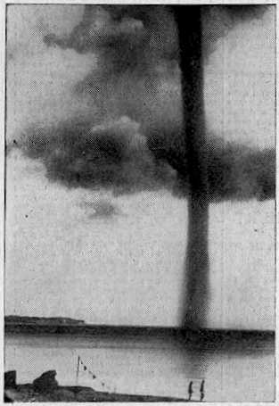
Waterspout off Rugen Island, Baltic Sea 1937

Waterspout off Rugen Island, Baltic Sea 1937

Waterspouts are (simplistically) tornadoes at sea, or on rivers and lakes. They have usually been regarded as curiosities of nature, because, unlike tornadoes, they do not often inconvenience the human race. Many waterspouts are feeble vortices which probably could not even come into existence in the turbulent air over the land, but they should not be taken lightly. Spouts have crossed onto land and become tornadoes, and some are tornadoes which have passed onto water. Even spouts far out in the ocean can be of tornadic size and power.

'Waterspout' is a rather inappropriate name, since spouts consist almost entirely of whirling cloud, with a plume of spray (the cascade) at the surface whipped up by the vortex as it touches the water. They do illustrate the difficulty of studying natural phenomena in the days before video and photography. Spouts could not be predicted, captured, or studied at leisure. Any student of waterspouts would have to rely on the accounts of people who had seen one, and they were not seen very often. They didn't even leave any physical traces unless they came ashore, which was an even rarer event. This is why the idea that spouts were literally waterspouts, streams of water pouring from the clouds (and raising spray when they hit the sea) lasted so long. An 18th Century scientist, defending the stream-of-water theory, even said, "the wonderful catalogue of nature needed not whirlwind-waterspouts to increase the number."

Waterspouts are whirlwinds, of course (something the Roman poet Lucretius knew), but it seems that powerful spouts can carry large amounts of water in the lower parts of their vortex. Some even lift water into their parent cloud, as shown by falls of salt rain after the spout has dissipated. Waterspouts are usually held responsible for the mysterious falls of fish and other aquatic animals. There are difficulties with this theory, but nobody has yet come up with a better one.

The chronology of remarkable waterspouts below is not inclusive. Many unusual spouts have had to be left out due to lack of space.

MARITIME NOTES:

Riverdance ferry will not be cut up - salvors


Riverdance


REFLOATING
the stricken Blackpool ferry will be later rather than sooner. The Riverdance does not look set to move until towards the end of the two weeks salvors described as "a window of opportunity".

Weather has played a part in hampering efforts to right the 6,000-ton vessel, which has been stuck on the beach near Anchorsholme Park since the start of February.

View our Shipwreck online special

See The Riverdance webcam

See our Riverdance picture gallery - updated daily

Salvage crews said there was a chance to move the ship sometime between now and March 13, but they say this is most likely to happen towards the end of this period.


Coastguard bosses insist the plan is still to right and then refloat the Riverdance – denying rumours that the move would be impossible and salvors would have to cut it up.

Oil Tanker Towed to Dock After SOS Call

YANBU, 6 March 2008 — An oil tanker carrying one million barrels of crude sent out a distress signal and was towed back to the King Fahd Industrial Port in Yanbu.

The ship, which reported engine failure about 200 kilometers from the port, arrived back at the port yesterday, officials told Arab News.

“KFIP’s emergency operation’s team rescued the oil tanker meandering amid the coral reefs following engine failure off the Duba coast,” Hammoud Al-Saadi, director general of the port, told Arab News yesterday.

Venture Navigation Co., Ltd. of Greece owns the 20-year-old Dominican-registered ship, according to Lloyd’s Registry. The ship was destined for the port of Aqaba, Jordan.

The distress call said the ship’s engines had broken down and was floating with the currents about 200 kilometers from Yanbu.

The rescue team found the captain of the ship steering without power as the weather was turning nasty. No injuries were reported.

“The successful operation averted a shipwreck and a major environmental disaster. The tanker was floating at an area close to virgin coral reefs. Any leakage of the ship’s load would have devastated the reefs,” Al-Saadi said.

Desalination plants in nearby Duba would have been affected by an oil spill, the port official added.

“Three powerful towboats struggled for 48 hours to bring the loaded tanker safely to the dock in Yanbu,” he said.

Oil from the Eastern Province is piped across the Kingdom for export from this northwestern port city. The western coast of Saudi Arabia is a maze of coral heads that can potentially damage and sink sea vessels. An accident involving a full oil tanker colliding with these underwater columns has a potential to cause a major environmental disaster.


RS