Showing posts with label hurricane hunters. Show all posts

Thursday, March 6, 2008

NOAA Invests $3 Million for Unmanned Aircraft System Testing

Pilotless Craft Gather Data for Hurricane Forecasts, Climate, West Coast Flood Warnings

+ High Resolution (Credit: NOAA)

Unmanned aircraft bearing automated sensors may soon help NOAA scientists better predict a hurricane’s intensity and track, how fast Arctic summer ice will melt, and whether soggy Pacific storms will flood West Coast cities. All three efforts are part of NOAA’s Unmanned Aircraft Systems program. NOAA recently invested $3 million in federal money to explore the use of the crewless vehicles for wide-ranging research designed ultimately to help save lives and property. NOAA officials announced the funding award today at the annual meeting of the American Meteorological Society in New Orleans.

“This technology has the potential to revolutionize our monitoring of the entire Earth,” said Marty Ralph, a research meteorologist at NOAA’s Earth System Research Laboratory in Boulder, Colo., and manager of NOAA’s UAS program. “Data gathered by unmanned aircraft can help us understand how humans are affecting the planet and how we might mitigate the impacts of natural disasters resulting from severe weather and climate.”

Starting this summer, unmanned aircraft will take instruments on research flights that are too dangerous or too long for pilots and scientists. NOAA, working with university and industry partners, will lead three test projects:

  • Atlantic and Gulf Hurricanes: Between August 1 and October 31, small unmanned vehicles will fly into the eye of Atlantic and Caribbean hurricanes at low altitudes too risky for crewed aircraft. The data will help experts diagnose maximum wind speeds and storm physics to improve hurricane intensity forecasts.
  • Arctic Climate Change: Later this year, a larger unmanned aircraft will observe sea ice conditions and track the locations of seal populations as the climate warms. Ice and atmospheric data will help scientists figure out how clouds, soot, and other airborne particles are helping to melt Arctic ice faster than climate models project from greenhouse gases alone.
  • Pacific and West Coast Storms: In spring 2009, both low- and high-altitude unmanned vehicles will fly over the Pacific to study “atmospheric rivers,” long arms of moisture from ocean storms that bring heavy rain and snow to the West Coast. The data could help forecasters warn water resource managers in time to adjust reservoir levels and avoid flooding and will shed light on weather and climate processes that affect water resources across the arid west.

The image “http://www.noaanews.noaa.gov/stories2008/images/lowleveluas_midsize.jpg” cannot be displayed, because it contains errors.

+ High Resolution (Credit: NOAA)

Future missions will help monitor fisheries, track Greenland glaciers, preserve natural resources, and provide firefighters with key wildfire data. Murky plumes of volcanic emissions and urban pollution will also be targets for dirty work by unmanned vehicles.

Unmanned planes can loiter in the sky over a storm or a forest fire or continue nonstop to a distant target area, such as Antarctica. Some can reach any location on Earth in one trip. Solar-powered vehicles can fly for days at a time. Small vehicles launched from ships at sea can vastly multiply a ship’s observation area to gather rare data in remote regions.

NOAA’s cooperative institutes at Mississippi State University and the universities of Alaska, Colorado, Hawaii, and Maryland are regional partners in leading the testbeds, along with Scripps Institution of Oceanography.

The National Oceanic and Atmospheric Administration, an agency of the U.S. Commerce Department, is dedicated to enhancing economic security and national safety through the prediction and research of weather and climate-related events and information service delivery for transportation, and by providing environmental stewardship of our nation's coastal and marine resources. Through the emerging Global Earth Observation System of Systems (GEOSS), NOAA is working with its federal partners, more than 70 countries and the European Commission to develop a global monitoring network that is as integrated as the planet it observes, predicts and protects.

BE READY!
Heads-up on bad weather: Be prepared

CHARLESTON — Tom Watson knows there are some people who don’t do what they’re supposed to do when the area’s threatened with bad weather.

The director of the Coles County Emergency Management Agency said he’s heard stories of people letting their curiosity get the best of them.

“I’ve had a lot of people tell me that when the sirens sound, they run outside to see what’s going on,” he said.

Watson said he wants to give people a heads-up about the upcoming severe weather season and what they really should do when bad weather threatens. The Illinois Emergency Management Agency designated this week as “Severe Weather Preparedness Week” in the state, and Watson said he doesn’t think many people are ready as they should be.

The “first priority” is to get out of the storm, he said. If a warning siren sounds for 3 minutes or longer, there’s a tornado approaching and it’s time to seek shelter, not watch the skies, he explained.

And a tornado doesn’t have to be in the immediate vicinity for conditions to be hazardous, as the debris scattered by winds of up to 200 mph from an approaching tornado is one of the storm’s most deadly aspects, he added.

“It’s very dangerous to get out in that wind,” Watson said. “It can pick up anything and make it a projectile.”

But nearly as important, he continued, is to have a plan for what to do when a storm comes, something that includes making sure that everyone in the house knows where to go.

Children need to know what to do if their parents aren’t around, he noted.

Recommended places of shelter include basements or the lowest floor of a building in an interior hallway, closet or bathroom without windows. Workplaces should have designated shelter areas, and people in vehicles should seek shelter and not try to outrun the storm, according to the National Weather Service.

A family should also be sure it has about a three-day supply of food, water, clothing, medicines and other items that people can “grab it and go with it” because they might not be readily available right after a storm, Watson added. Law enforcement and other emergency agencies will be busy after the bad weather, so it won’t be known how long before help might come, he said.

“You might have to get along on your own for several hours,” Watson said.

Tornadoes can sometimes develop suddenly and not appear on weather radar, Watson added. That’s why it’s important for people to follow weather forecasts and be ready ahead of time when a severe storm might approach, he said.

According to the National Weather Service, Coles County is 14th in Illinois for the most tornadoes the last 57 years (Douglas was 13th, and the only other one in this general area was Champaign, at 11th). Watson credited better spotting and radar technology for likely identifying some tornadoes that wouldn’t have been noticed in the past.

“I know we’ve had a lot of reports in the last five or six years,” he said.

Coles County will participate in a statewide tornado drill Tuesday, the same day as regular monthly testing of warning sirens, and a test warning will be issued for every county in the state. Watson said his agency will take the opportunity to check equipment, and the annual event is when he urges local schools to conduct severe weather drills.

Contact Dave Fopay at dfopay@jg-tc.com or 348-5733.

TWISTERS IN RIO!

Tornados em Buenos Aires - 03/03/2008 00:00

Duas trombas d'água se formaram sobre o Rio da Prata

Duas trombas d'água se formaram na costa da cidade de Buenos Aires na tarde deste domingo. As trombas d'água afetaram as costas de Martínez, Tigre e Acasusso e chegaram a ser fotografadas de edifícios do bairro de Olivos na capital argentina. O fenômeno ocorreu por volta das cinco e meia da tarde, hora de Brasília, com duração aproximada de quinze minutos. A Prefeitura Naval informou que não houve nenhum pedido de emergência, apesar da grande quantidade de embarcações no litoral de Buenos Aires no mundo dos tornados. As imagens remetidas pelos leitores do jornal argentino La Nación são espetaculares e documentam como nunca até hoje um evento tornádico no Rio da Prata.


WATERSPOUTS ON THE STARBOARD BOW!

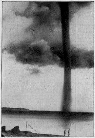
Waterspout off Rugen Island, Baltic Sea 1937

Waterspout off Rugen Island, Baltic Sea 1937

Waterspouts are (simplistically) tornadoes at sea, or on rivers and lakes. They have usually been regarded as curiosities of nature, because, unlike tornadoes, they do not often inconvenience the human race. Many waterspouts are feeble vortices which probably could not even come into existence in the turbulent air over the land, but they should not be taken lightly. Spouts have crossed onto land and become tornadoes, and some are tornadoes which have passed onto water. Even spouts far out in the ocean can be of tornadic size and power.

'Waterspout' is a rather inappropriate name, since spouts consist almost entirely of whirling cloud, with a plume of spray (the cascade) at the surface whipped up by the vortex as it touches the water. They do illustrate the difficulty of studying natural phenomena in the days before video and photography. Spouts could not be predicted, captured, or studied at leisure. Any student of waterspouts would have to rely on the accounts of people who had seen one, and they were not seen very often. They didn't even leave any physical traces unless they came ashore, which was an even rarer event. This is why the idea that spouts were literally waterspouts, streams of water pouring from the clouds (and raising spray when they hit the sea) lasted so long. An 18th Century scientist, defending the stream-of-water theory, even said, "the wonderful catalogue of nature needed not whirlwind-waterspouts to increase the number."

Waterspouts are whirlwinds, of course (something the Roman poet Lucretius knew), but it seems that powerful spouts can carry large amounts of water in the lower parts of their vortex. Some even lift water into their parent cloud, as shown by falls of salt rain after the spout has dissipated. Waterspouts are usually held responsible for the mysterious falls of fish and other aquatic animals. There are difficulties with this theory, but nobody has yet come up with a better one.

The chronology of remarkable waterspouts below is not inclusive. Many unusual spouts have had to be left out due to lack of space.

MARITIME NOTES:

Riverdance ferry will not be cut up - salvors


Riverdance


REFLOATING
the stricken Blackpool ferry will be later rather than sooner. The Riverdance does not look set to move until towards the end of the two weeks salvors described as "a window of opportunity".

Weather has played a part in hampering efforts to right the 6,000-ton vessel, which has been stuck on the beach near Anchorsholme Park since the start of February.

View our Shipwreck online special

See The Riverdance webcam

See our Riverdance picture gallery - updated daily

Salvage crews said there was a chance to move the ship sometime between now and March 13, but they say this is most likely to happen towards the end of this period.


Coastguard bosses insist the plan is still to right and then refloat the Riverdance – denying rumours that the move would be impossible and salvors would have to cut it up.

Oil Tanker Towed to Dock After SOS Call

YANBU, 6 March 2008 — An oil tanker carrying one million barrels of crude sent out a distress signal and was towed back to the King Fahd Industrial Port in Yanbu.

The ship, which reported engine failure about 200 kilometers from the port, arrived back at the port yesterday, officials told Arab News.

“KFIP’s emergency operation’s team rescued the oil tanker meandering amid the coral reefs following engine failure off the Duba coast,” Hammoud Al-Saadi, director general of the port, told Arab News yesterday.

Venture Navigation Co., Ltd. of Greece owns the 20-year-old Dominican-registered ship, according to Lloyd’s Registry. The ship was destined for the port of Aqaba, Jordan.

The distress call said the ship’s engines had broken down and was floating with the currents about 200 kilometers from Yanbu.

The rescue team found the captain of the ship steering without power as the weather was turning nasty. No injuries were reported.

“The successful operation averted a shipwreck and a major environmental disaster. The tanker was floating at an area close to virgin coral reefs. Any leakage of the ship’s load would have devastated the reefs,” Al-Saadi said.

Desalination plants in nearby Duba would have been affected by an oil spill, the port official added.

“Three powerful towboats struggled for 48 hours to bring the loaded tanker safely to the dock in Yanbu,” he said.

Oil from the Eastern Province is piped across the Kingdom for export from this northwestern port city. The western coast of Saudi Arabia is a maze of coral heads that can potentially damage and sink sea vessels. An accident involving a full oil tanker colliding with these underwater columns has a potential to cause a major environmental disaster.


RS

Tuesday, November 20, 2007

Hurricane Detection Gains an Ally

Hurricane Detection Gains an Ally
By Joshua Hill


Friday, November 16, 2007

Weather is tough to predict at the best of times, with Mother Nature not necessarily bringing the human need to know what clothes to wear in to her equations. But it gets even trickier when trying to predict hurricanes.

The 2005 hurricane season was a notable time for meteorologists, as they witnessed quickly intensifying tropical depressions turn in to massive hurricanes in the blink of an eye. Sadly, a similar event happened with Hurricane Humberto making the leap from depression to category one hurricane in less than 24 hours.

“It made the transition from tropical depression to hurricane within 24 hours right before landfall. It was a record breaker,” says NASA atmospheric scientist Robbie Hood.

No one knows if this is a trend that will continue, or just a few freak turns of climate.

“Forecasting intensity is one of the biggest problems we have right now with hurricanes,” says Hood. But Hood and her team of researchers at NASA’s Marshall Space Flight Center are making strides toward solving that problem with a new invention called HIRAD, short for Hurricane Imaging Radiometer.

To construct a proper computer model to predict the outcome of a hurricane, one needs to be able to measure wind speeds at the base of the storm. In particular, winds close to the eye of the storm, and in the eye wall. But, naturally, that close to the frothing torrent of wind, is not an easy place to acquire data.

This is where HIRAD comes in to the picture. Designed to operate from an airplane or satellite, “HIRAD will see from above through a hurricane’s heaviest rains and thickest clouds to measure the intense winds at the surface of the ocean,” says Hood.

“Strong winds sweep and swirl across ocean waves, whipping up foamy white froth,” explains Hood. “HIRAD measures microwave radiation naturally emitted by this froth; the stronger the winds, the more froth, and the more microwave radiation.”

Also, HIRAD measures a wider swath of the ocean, meaning that there will be less passes to make, and the information will be acquired quicker. It is small, lightweight and doesn’t use much energy. No moving parts, inexpensive and with the potential to be mounted in a satellite, makes HIRAD a perfect companion to weather predictors.

HIRAD is gaining popularity, and it is hoped it will make its first trial run in the hurricane season of 2009. But funding is vital, for the progression of HRIAD from prototype to working tool. It will need to pass the 2009 trial run, and hopefully with funding, be installed upon a satellite.

“When you fly an instrument on a satellite, it helps everybody on the globe,” she says. “It improves forecasting around the world, for countries that don’t have the ground-based radar and aircraft instruments larger countries have.”

Karen Stephens, HIRAD Project Manager, adds, “In the post-Katrina era, it is especially satisfying to be working on something so immediately beneficial and possibly life-saving.”

MARITIME NOTES

Salvage of Den Den begins officially

By Team Mangalorean
Photographs: Rajesh Shetty

MANGALORE, November 15, 2007: The Gulf based Offshore Supply Vessel (OSV) Al-Haml arrived in Mangalore today and proceeded directly to the spot where the Eritrean freighter M.V. Den Den lays on its side since June 23. The arrival of the vessel actually heralds the beginning of the salvage operations.

Al-Haml carries high profile equipments used in such complicated salvage and rescueoperations that included drilling and diving equipments. The OSV is also equipped with three tanks each having 36 cubic metre space which will come handy for emptying fuel tanks of the Den Den. The OSV also carries on board pollution control equipment.

The salvage team which has arrived from Singapore had a closer look at the freighter and has carried out strength determination tests on the hull where it will attach a Hot Tap to ciphon the fuel of the sunken ship. There is yet another support team waiting for helping the onboard team.

The owners of the ship and the government of Eritrea has also given its permission for the salvage which had been secured from the diplomatic channels. The customs has also permitted the retrieval of fuel from the tanks of the sunken ship. The Karnataka State Pollution Control local unit has been monitoring the salvage operation for any spillage of oil that could harm the marine life.


CYCLONE SIDR UPDATE

Situation Report by UN OCHA:

I. Situation in Bangladesh

1. Cyclone Sidr (Category IV) hit Bangladesh on the evening of 15 November. The cyclone, originating from a depression over the Bay of Bengal on 11 November, hit offshore islands at 1830 hours and made landfall across the southern coast from Cox's Bazaar toward the Satkhira districts at 2030 hours local time. Heavy rains were experienced throughout the country, including the capital Dhaka. The first area hit by Cyclone Sidr was Hiron Point and part of the mangrove forest Sundarbans in Bagerhat and Dublar Char Island in Barguna. According to the Bangladesh Meteorological Department, Cyclone Sidr had a radius of 500 kilometres with the eye of the storm 74 kilometres wide and wind speeds reaching between 220-240 kilometres per hour. The storm caused extensive damage, in particular in the south-western districts, as it moved north into central Bangladesh and was downgraded to a Category II tropical storm. The weather is currently calm.

2. Official reports indicate that the initial death toll is 2,027 people, with 1,451 injured and 454 missing. These figures are expected to increase significantly as the need assessments are completed and will be reported on 19 November. Reports indicate that over 27 million people from 25 districts were affected by the severe cyclonic storms. The 12 hardest hit districts were Bagerhat, Patuakhali, Barguna, Pirojpur, Barisal, Jhalkhati, Bhola, Mandaripur, Gopalgonj, Shariatpur, Khulna and Satkhira. Many structures have been damaged or destroyed, damage to crops is extensive and roads are damaged or blocked by debris. The cyclone caused severe reduction in power production, resulting in a near countrywide blackout for over 36 hours, further disruptions to telecommunications and water supply.

3. Preliminary assessments indicate that emergency needs should be concentrated on non-food items, food aid, nutrition, water and sanitation, shelter and disease surveillance. The longer term perspective calls for rehabilitation of livelihood, infrastructure, health and educational services and increased shelter capacity.

II. National Response in Bangladesh

4. To date, the Chief Adviser has allocated 100 million taka for relief and house construction in eleven districts. The Deputy Commissioners are procuring and collecting sufficient amount of dry food to respond to the current situation. The Ministry of Food and Disaster Management (MoFDM) has allocated 4,000 metric tonnes of rice, 5,000 tents, 17,000 blankets and 30 million taka as gratuitous relief grants, to date. A special fund was established allocating 350 million taka for housing construction grants. 13,000 bundles of corrugated iron sheets are ready for immediate distribution. The Bangladesh Armed Forces Division deployed several aircrafts and a number of helicopters. Six Bangladesh Navy ships are conducting rescue, evacuation, relief and reconnaissance operations in the worst storm affected areas. Several central control rooms of different GoB agencies at national, district and upazila levels have been active round the clock since the first cyclone warning was issued. 732 medical teams are working in the affected areas.

5. The Government of Bangladesh (GoB) early warning and preparedness systems were activated prior to the cyclone hitting landfall, which had a significant mitigating effect in this emergency. Disaster preparedness measures included the evacuation of approximately 3.2 million people from along the coastline of 15 districts to safe places. Alarms were raised and relief and rescue items were stockpiled.

6. The Government of Bangladesh called an immediate meeting of the Disaster and Emergency Response group (DER) on 15 November, consisting of representatives from the GoB, United Nations, Donors, national and international NGOs. The GoB emphasized that the humanitarian community should coordinate closely with central and local Bangladesh authorities. A follow up meeting was held on 18 November, where many donors pledged support to the GoB. The next DER meeting will be held on 22 November.

III. International Response in Bangladesh

7. The UN Country Team, IFRC, and NGOs, including Save the Children, World Vision International, CARE, Caritas, OXFAM, Islamic Relief, ACT, Adventist Development and Relief Agency (ADRA), Muslim Aid, and Plan, provided support to the Government of Bangladesh through extensive emergency response precautions, including mobilizing in-country staff and pre-positioned relief stocks across southern Bangladesh.

8. Under the coordination of the DER, a United Nations team of 12 experts left Dhaka to assist with assessment in affected areas. The United Nations is distributing 208 tonnes of high-energy biscuits to assist an estimated 850,000 cyclone affected people. 240,000 packets of water purifying powder are reaching 48,000 families. Shelter materials (thick polyesters) will also be distributed to 18,000 households whose houses were destroyed by the storms. Partners will start distribution of dry food (flattened rice and molasses) to 70,000 affected families from 18 November. Medical officers are available to assist the GoB response, including four to assist in coordinating the central response. USD 50,000 was made available for water and supplies and transportation. More relief will be made available following initial determination of needs.

9. The United Nations Disaster Management Team (UN DMT) met on 16 November to coordinate response and assessment and take early stock of the situation. A mission from UN OCHA Regional Office arrived in Dhaka on 17 November to assist with the Central Emergency Relief Fund (CERF) process and support the UN RC with coordination. UN Heads of Agencies go on mission to the worst affected districts to assess the extent of damage on 19 November.

10. IFRC launched a preliminary emergency appeal on 16 November for US$ 3.5 million in cash, kind, or services to support the Bangladesh Red Crescent Society to assist 235,000 beneficiaries for a period of 9 months.

11. Several donors, including the European Union, Germany, Saudi Arabia, Switzerland United Kingdom, United States of America, have pledged to assist the affected population of Bangladesh. More detailed information is expected to be provided on 19 November.
Number of Deads: 2027 persons Number of Injured persons: 1451 persons Number of Evacuated persons: 650 000 persons Infected: persons


RS


Tuesday, September 4, 2007

A CAT 5 "Felix" Makes Landfall

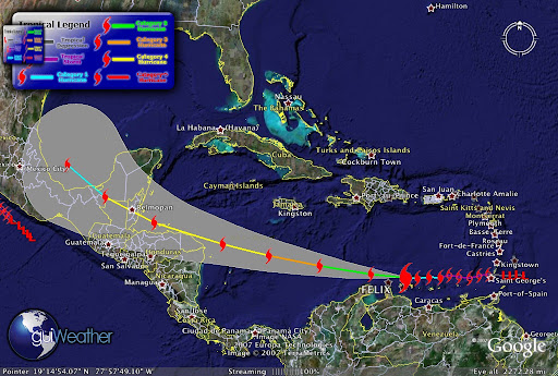
Hurricane Felix has made landfall in Northeast Nicaragua, northeast of Puerto Cabezas. Felix is now a Cat 5 storm.

Felix's current storm position as of
Sep 4 - 12:00 UTC is Latitude: 14.3
Longitude: -83.2 with maximum winds of 160 mph and a pressure of 935 mb.

During the morning hours Felix gained Category 5 strength from the warm Caribbean waters. This is a very powerful and dangerous storm.

Up to 40,000 Hondurans were evacuated to shelters but some 15,000 people were unable to find transportation and were forced to ride out the storm in their homes.
Its too early to report on any damage but we will be updating through out the day, so stay tuned.....


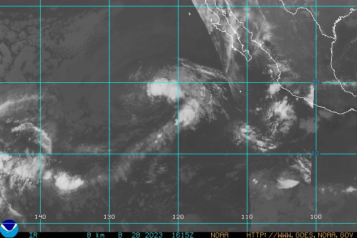
In the Pacific....

TS Henriette is now Hurrciane Henriette a Category 1 Hurricane with its outer bands approaching the southern tip of Baja California....

Henriette forecast storm position as of Sep 4 - 09:00 UTC was
Latitude: 21.4/ Longitude: -109.1
Maximum winds of 75 mph.


latest goes west infra red hurricane image


We will keep you posted!
RS

Sunday, September 2, 2007

Hurricane Felix Update - CAT 3


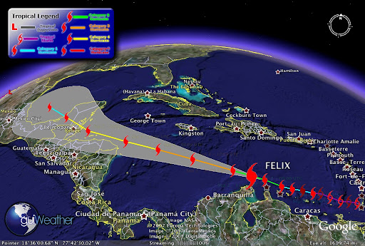
Hurricane Felix is now a "major" Category 3 hurricane as it rages over the warm waters of the Caribbean, aimed at Central America or Mexico's Yucatan Peninsula, NWS and NHC weather forecasters report.


Felix passing Aruba!


Latest Track!

FELIX -Current Storm Position as of Sep 2 - 18:00 UTC -Category 3 Hurricane
Maximum winds of 125 mph and a pressure of 964 mbLatitude: 13.4 Longitude: -71.2


Keep ya posted!

RS

Hurricane Felix

Well we have number two of the season and its name is FELIX and its a CAT 2

Its current storm position as of Sep 2 - 09:00 UTC. Latitude: 12.8 Longitude: -68.7 heading for the island of Aruba. Maximum winds of 100 mph and a pressure of 984 mb.

As of Sep 2 - 05:26 UTC. Hurricane Hunter KNHC AF306 just ahead of the storm reports, Altitude of Plane: 10036 feet. Wind Direction: 280°. Wind Speed: 32 knots. Temperature: 5°C Dewpoint: 5°C..
The storm was upgraded from a tropical storm to a Category 1 hurricane Saturday evening, becoming the second Atlantic hurricane of the season.

It had sustained maximum winds of at least 80 mph early Sunday. A tropical storm warning and hurricane watch were in effect for Aruba, Bonaire and Curacao.

At 2 a.m. EDT, Felix was centered about 45 miles northeast of Bonaire and 145 miles east of Aruba and was moving westward at about 18 mph, the U.S. National Hurricane Center said.

Forecasters said satellite images showed Felix steadily expanding in size.

Earlier in the day Felix brought heavy rains and strong winds to Grenada as a tropical storm, snapping small boats loose from their moorings, temporarily knocking out local radio and TV stations and toppling utility lines. No injuries were reported.


We got to keep an eye on this one!

RS

Friday, August 31, 2007

SMURFING (SFRM) HURRICANE DEAN

"Smurfs" Vs. Hurricane Dean

WIRED
By David Axe

August 19, 2007 | 9:54:06 PM

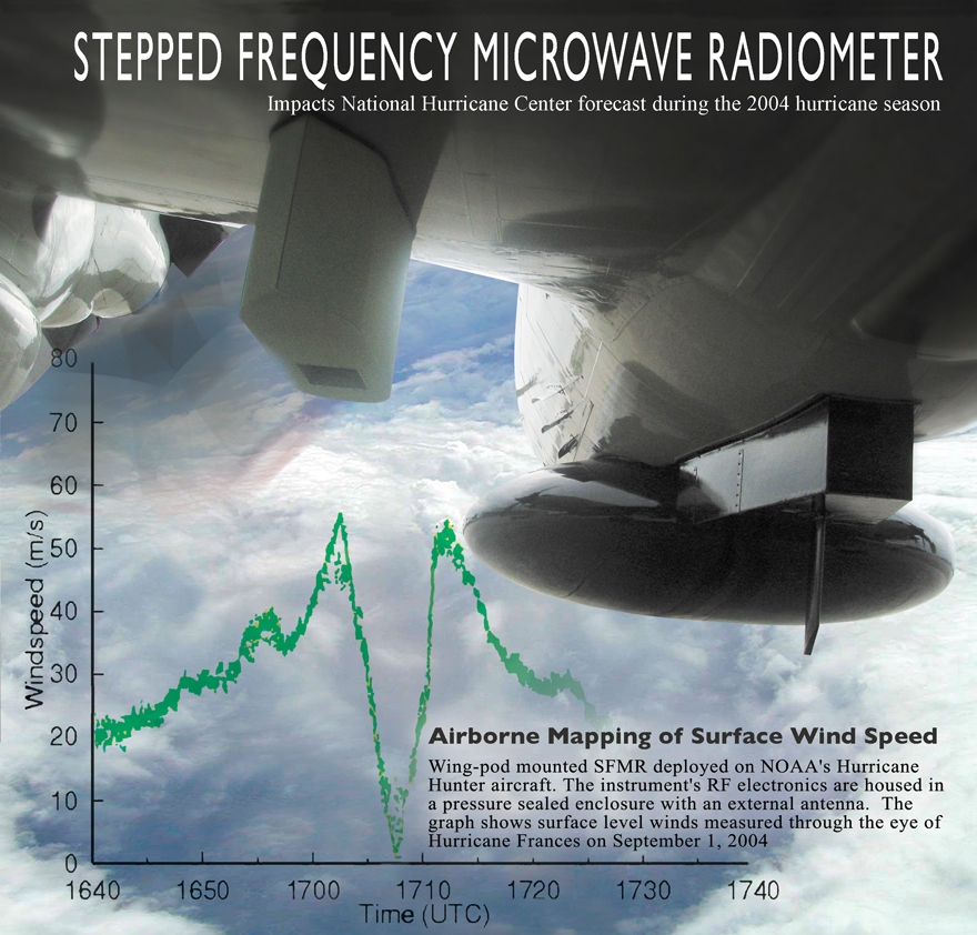
Two years ago Hurricane Katrina kicked the U.S. government's ass. Now, as Hurricane Dean sweeps past Jamaica on its way to the U.S. Gulf Coast, FEMA, the Coast Guard and the other military services are poised to prove they can do better the second time around. The military response actually began days ago when the Air Force's WC-130J hurricane-hunting patrol planes deployed brand-new sensors to more accurately predict when and where Dean will hit and what kind of damage it will do, according to the service. The "Stepped-Frequency Microwave Radiometer," or "smurf,"

allows the Citizen Airmen of the Hurricane Hunters to constantly measure surface winds directly below the aircraft. The smurf can also determine rainfall rates within a storm system. This, in addition to wind speeds at flight level, provides structural detail of the storm. "The SFMR will be the biggest advance I can think of to improve hurricane intensity forecasts," said Max Mayfield, former director of the [National Hurrican Center].

The data collected by the Hurricane Hunters increase the accuracy of the NHC forecast by 30 percent, a rate which will undoubtedly increase with the use of the smurf. This data enables the NHC to more accurately predict the path of storms in order to save lives and narrow areas of evacuation, according to NHC forecasters.


U.S. Air Force Fact Sheet

STEPPED-FREQUENCY MICROWAVE RADIOMETER
SFMR Ready for 2007

PURPOSE:

The Stepped-Frequency Microwave Radiometer is a state-of-the-art instrument designed to continuously and accurately measure the winds at the ocean's surface directly below the aircraft. The SFMR, affectionately known as "smurf", is installed on the WC-130J within a pod attached to the aircraft's wing. As the plane flies through a storm, the SFMR senses microwave radiation naturally emitted from foam created on the sea by winds at the surface. Computers then determine wind speeds based on the levels of microwave radiation detected. Currently, winds are extrapolated from the winds at the aircraft's altitude or from a dropsonde released from the aircraft, however, the SFMR directly measures the surface winds and is not confined to a single point like the dropsonde. This constant measurement of surface winds gives the National Hurricane Center a more complete picture of the storm.

The SFMR can also determine rainfall rates within a storm system. This, in addition to wind speeds at flight level, provide structural detail of the storm.

Two Hurricane Hunter aircraft will be equipped with the SFMR by the end of June with one added each month until all 10 WC-130J aircraft are outfitted with the SFMR pod, the last to be equipped in March, 2008.


Hurricane Hunters fly year's first storm mission over Atlantic


SPECIFICATIONS:

Radiometer Type Hatch
Tuning bandwidth 4.6 -7.2 GHz
Number of channels Up to 8
Receiver Channel Bandwidth 50 MHz
Antenna Type Corrugated horn
Antenna Beamwidth (3 dB) 20-28 deg Polarization Linear
Measurement precision 0.17 K (1second averaging)
Electronics Power Requirements 28VDC, 2A
Thermal Control Power Requirements 28VDC, 4A (max)
Power 168 W
Operating Temperature -65°C to +40°C
Humidity 0 to 100%
Size (L x W x H) 24" x 11" x 13"
Weight 40 lbs.


WP-3D Stepped Frequency Microwave Radiometer (SFMR)


Measurement of the hurricane surface wind field, and in particular the estimation of wind maxima, has long been a requirement of the Tropical Prediction Center/OAR. The NOAA/Hurricane Research Division's Stepped-Frequency Microwave Radiometer (SFMR) is the prototype for a new generation of airborne remote sensing instruments designed for operational surface wind estimation in hurricanes.

The SFMR has a downward pointing antenna which passively reads the microwave radiation coming from the ocean surface. By making assumptions about the vertical structure of the atmosphere together with sea surface temperature measurements by a downward-looking airborne infrared radiometer, reasonable estimates of the ocean surface brightness temperature can be made at six frequencies between 4.6 and 7.2 GHz. Wind speeds are then calculated assuming linear increase in wind speed with these brightness temperatures. Since some of the frequencies are more attenuated by rainfall than others, an estimate of the rainfall rate below the airplane can also be made.

Project page for SFMR development
Report on SFMR in Katrina and Rita 2005


Weather Story:

Well we have Tropical Storm Gil and Tropical Depression ELEVEN E (RESOE EDIS) off the Pacific Coast that we are keeping an eye on. There are also a couple of interesting tropical waves forming off the African Coast (see Tropical Weather Outlook and Storm Watch-Carib interactive graphics- left side of page)!

Chicago Weather for the weekend? Just great! Have a wonderful Labor Day Weekend!

RS