Showing posts with label NOAA’s Severe Storms Lab. Show all posts

Tuesday, July 22, 2008

NOAA Predicts Largest Gulf Of Mexico 'Dead Zone' On Record

NOAA Predicts Largest Gulf Of Mexico 'Dead Zone' On Record

ScienceDaily (July 16, 2008) NOAA-supported scientists from the Louisiana Universities Marine Consortium and Louisiana State University are forecasting that the "dead zone" off the coast of Louisiana and Texas in the Gulf of Mexico this summer could be the largest on record.

The researchers are predicting the area could measure a record 8,800 square miles, or roughly the size of New Jersey. In 2007, the dead zone was 7,903 square miles. The largest dead zone on record was in 2002, when it measured 8,481 square miles. The official measurement of this year's dead zone is slated to be released in late July. Researchers began taking regular measurements of the dead zone in 1985.

"The prediction of a large dead zone this summer is due to a combination of large influx of nitrogen and exceptionally high flows from the Mississippi and Atchafalaya rivers," said LSU scientist R. Eugene Turner.

The dead zone is an area in the Gulf of Mexico where seasonal oxygen levels drop too low to support most life in bottom and near-bottom waters. This low oxygen, or hypoxic, area is primarily caused by high nutrient levels, which stimulates an overgrowth of algae that sinks and decomposes. The decomposition process in turn depletes dissolved oxygen in the water. The dead zone is of particular concern because it threatens valuable commercial and recreational Gulf fisheries.

Research indicates that the nearly tripling of nitrogen levels into the Gulf over the past 50 years from human activities has led to a dramatic increase in the size of the dead zone. Various models are useful in evaluating the influence of nitrogen loads and other factors on the size of the dead zone. The LSU model has a strong track record of accurately predicting the dead zone's size.

"The strong link between nutrients and the dead zone indicates that excess nutrients from the Mississippi River watershed during the spring are the primary human-influenced factor behind the expansion of the dead zone," said Rob Magnien, director of the NOAA Center for Sponsored Coastal Ocean Research. "This analysis will greatly inform the development of federal, state and local efforts to reduce the dead zone's size."

The forecast is based on a mathematical model developed by LSU through NOAA's long-term research investment by CSCOR's Gulf of Mexico Ecosystems and Hypoxia Assessment. The model incorporates U.S. Geological Survey data on the amount of nitrogen reaching the Gulf of Mexico in May. NOAA has been funding investigations into the dead zone since 1990.

WEATHER NOTE

Tornado sirens questioned on Iron Range

VIRGINIA, Minn. (AP) - Officials in the Virginia area are discussing what should be done about malfunctioning tornado sirens.

During tornado alerts Monday evening, some of Virginia's warning sirens didn't go off. While funnel clouds were reported, no tornadoes reportedly touched down.

Virginia Mayor Steve Peterson says it's a wake-up call for the city. He says city officials and residents are fortunate nothing happened.

Some of Virginia's sirens are more than 40 years old.

Peterson says Virginia will likely have to replace the sirens, because he says it doesn't make much sense to repair such old equipment.

In nearby Eveleth, the sirens did sound. But sirens in Gilbert were silent because of a mixup, and Mountain Iron doesn't have an alarm system

Officials agree that Wisconsin’s disaster laws need an overhaul.

A new panel of legislators, emergency management officials and relief workers will start meeting July 30 to suggest ways to streamline those laws.

It would have been almost impossible to hold a session a month ago when floods closed many roads in southern Wisconsin.

It’s been 20 years since the state’s emergency laws have gotten a comprehensive review.

Since then, lots of things have been added piecemeal.

For one thing, the law does not define “homeland security.”

Homelands used to be where our ancestors were from, until President Bush made it part of the post-Sept. 11 lexicon and state and local governments created their own homeland security agencies that seem to include everything under the sun.

Sen. Bob Jauch, D-Poplar, chairs the new study panel. He wants to examine the state’s response to recent disasters, including the floods, and the February snowstorm in which thousands of motorists were left stranded for up to 12 hours on Interstate 90 south of Madison.

Jauch also wants to find out if local agencies have the resources they need to recover from emergencies.

MARITIME NOTE

Unsecured cargo may have led to vessel sinking
MANILA, Philippines - Loose cargo on board the ill-fated M/V Princess of the Stars may have led to its sinking on June 21 while it was being lashed by typhoon Frank (international codename: Fensheng).

Philip Vasquez, a resident of Cebu and one of 28 people aboard a life raft that was swept to the coastal town of Mulanay in Quezon province, told the Board of Marine Inquiry (BMI) Friday that he was awakened at about 3 a.m. when waves as tall as the vessel continuously hit the seven-storey ferry.

The sun suddenly came out and the seas became calm at about 8 a.m. and he was sure that they were at the center of the typhoon at that time, said Mr. Vasquez, a graduate of maritime education at the University of Cebu. Thirty minutes later, the weather became worse and the boat eventually sank, taking with it some 500 lives.

When the interisland ferry was being battered by giant waves before noon, he said he heard that the cargo move as the vessel swayed. He said the moving cargo caused the tilting of the ship and led to its sudden capsizing.

His statement was supported by an earlier one made by a maritime expert who said the reason the doomed ferry lost its stability was because of the weight of "unsecured" cargo.

Nelson P. Ramirez, president and chairman of the United Filipino Seafarers, had said some of the vessels of Sulpicio Lines lack the proper equipment to ensure the safety of cargo — an observation made when he joined a team from the Maritime Industry Authority (MARINA) conducting an inspection to check the ships’ seaworthiness. MARINA is also investigating the possible need to cancel the certificate of public convenience issued to Sulpicio Lines.

Meanwhile, the broker contracted by Del Monte Philippines, Inc. to handle the documents regarding the toxic chemical shipment of Del Monte Philippines, Inc. (DMPI) appeared at the BMI hearing.

Dante Macaisa, CEVA Philippines country manager, told the board that Sulpicio Lines had prior knowledge of the contents of the 40-foot container van. He said the broker had presented several documents indicating that the shipment contained dangerous materials to a representative of the shipping firm.

After giving the local pro-forma bill of lading, Mr. Macaisa said the official stated that other documents were "not necessary" and gave them back to the broker.

Sulpicio Lines spokesperson Ma. Victoria Lim-Florido said there were no acknowledgment receipts executed by the broker.

"If there is an acknowledgment receipt, then that is proof that Sulpicio received [the documents from the broker]. But our position is [that] we never received the ocean bill of lading," she told reporters.

Mr. Macaisa confirmed they did not issue an acknowledgment receipt. In other transactions, Ms. Lim said, they execute acknowledgment receipts, especially as regards dangerous cargo. — Bernard U. Allauigan, BusinessWorld

RS


Wednesday, May 14, 2008

Experts: Twisters Getting Larger, Deadlier

Experts: Twisters Getting Larger, Deadlier

No End in Sight for Tornado-Ravaged Nation

By ASHLEY PHILLIPS

May 12, 2008 —

As communities rebuild after deadly tornadoes bulldozed their way from Oklahoma to Georgia and North Carolina over the weekend, experts say that this tornado season is bigger and deadlier than last year's, with little relief in sight.

Seventy-seven tornadoes tore through the country the past few days, according to preliminary reports at the National Oceanic and Atmospheric Administration Storm Prediction Center. In Georgia, more than 180,000 people were left without power, while 15 fatalities were reported in Missouri.

This year's count is already twice the number of tornadoes logged during last year's U.S. tornado season, which generally runs from mid-spring to early summer.

"So far, in terms of the number of tornadoes, this is one of the most active years to date," said Harold Bloom, a meteorologist at the National Severe Storms Laboratory in Norman, Okla.

Tornadoes develop from large, powerful thunderstorms known as super cell thunderstorms.

"One super cell thunderstorm can move many miles and can produce several tornadoes, a family of tornadoes," said Henry Margusity, a meteorologist at Accuweather.

"These thunderstorms will produce one tornado. It will develop, mature and dissipate and another will fall right behind it. & You're getting a lot of these very large thunderstorms developing."

The larger thunderstorms are producing more families of tornadoes earlier than before and the tornadoes themselves are staying on the ground longer than ever before in regions outside of "tornado alley," Margusity said.

Kansas, Oklahoma and parts of Texas officially make up this area, although the southeastern United States experiences its fair share of tornadoes during the season.

With more tornadoes have come more deaths. So far, 96 people have died this year. Last year, the entire tornado season end with 81 fatalities.

"This year everything's been shifted to the east, & which is why we've seen a higher death toll," he said. "They're happening in very highly populated areas of our country."

"The damage that you see is just incredible," he added.

And some people are at greater risk than others.

"If people didn't live in mobile homes or if they had a more permanent shelter to get into you could cut the deaths in half," said Paul Markowski, a Penn State meteorologist and a veteran storm chaser.

Of the 81 people who died in tornadoes in 2007, 52 were killed in a mobile home, according to National Oceanic and Atmospheric Administration statistics. Markowski and other scientists suggest creating permanent underground shelters in areas like mobile home parks that are more vulnerable to tornado damage.

"That's what's frustrating as scientists. &The reality is for a lot less money than the millions spent on science research, for a much smaller investment, you could probably have a much bigger impact," he said.

Different meteorologists offer different possible reasons for the tornado increase, from the jet stream pattern to changing water temperatures.

"There are several things going on the atmosphere: a progressive pattern in jet stream. & There's also plenty of fuel for these storms in the form of a sharp temperature contrast in the United States," said Jay Searles, a meteorologist at Pennsylvania State University. "There's been record heat and record cold over the month of April and the first part of May. Last year & everyone got warm in the same time. The temperature difference wasn't as strong."

Those extremes may be attributable to La Nina, a cooling of the Pacific Ocean, that has happened in the past year, Searles said.

"It's a normal phase," he said. "There may be a connection."

There may also be a connection to a warming Gulf of Mexico, which in the winter had temperatures that were a bit warmer than normal, Penn State's Markowski said. "The warmer that the ocean is the more water evaporates to its surface," Markowski said. Moisture is a key ingredient of tornado development.

"Years when the Gulf of Mexico is really warm, we tend to have more tornadoes."

Despite this, Markowski stressed that there is no proven connection between global warming and tornado development.

"People have bent over backwards to try to come up with generalizations about tornado activity," he said. "That's one of the biggest areas of uncertainly in the climate change community. There's no doubt that the earth is warmer than it has been. There's extremely high confidence that humans have contributed to warming. & What that warming means and how it translates in tornadoes and hurricanes, especially tornadoes, we don't know." What meteorologists do know, however, is that for now, there's no end in sight.

Severe thunderstorms, like those that produced the weekend's tornadoes are expected in Texas, Mississippi, Illinois and Iowa, according to Joe Schaeffer, a meteorologist at the Storm Prediction Center. On Wednesday, NOAA is predicting severe storms over central Alabama.

Although several meteorologists said that the tumultuous storm season could continue even through the end of summer, accurately predicting the outcome of a tornado season is near impossible.

"Anything beyond day three is a flip of the quarter," Penn State meteorologist Searles said.

Coast Guard Urges Mariners to Think Safety During Severe Weather

Coast Guard Urges Mariners to Think Safety During Severe Weather

PORTSMOUTH, Va., - The Coast Guard urges mariners to exercise extreme caution when transiting coastal and inland waterways as severe weather passes through the mid-Atlantic region today.

A gale warning is currently in effect for the inland and coastal waters of Virginia and North Carolina with northeastern winds forecasted to reach 30-35 m.p.h.

The Coast Guard has saved or assisted 17 people since the severe weather system entered the mid-Atlantic region earlier this weekend.

To prepare for severe weather, the Coast Guard urges to always:

-Wear their life jackets on the water.
-Check their current and expected weather and water conditions before heading out.
-File a float plan with friends, family members and their local marina before heading out. The list should include the number of passengers onboard the vessel, their destination and expected time of return.
-Always have a working radio onboard their vessel as cell phone coverage varies from region to region.
-Carry marine flares onboard their vessels to signal rescuers in distress and emergency situations.
-Boat owners are encouraged to check their mooring lines to insure their vessels do not break free during the sever weather.

Mariners are reminded that drawbridges along the coast may deviate from normal operating procedures and are generally authorized to remain closed up to eight hours prior to the approach of gale force winds of 34 knots or greater.

The gale warning is in effect until tuesday.

For current and detailed weather information in your area, consult the National Oceanagraphic and Atmospheric Administration website. http://www.noaa.gov/

MARAD – National Maritime Day events

On May 22, the United States celebrates National Maritime Day. In Washington, DC, a Eucharistic liturgy will be celebrated at St. Joseph’s Roman Catholic Church; a seminar will be conducted at the Rayburn House Office Building on environmental issues; and an observance ceremony will be conducted at the Roosevelt Memorial. (5/11/08).

RS

Tuesday, March 11, 2008

Understanding & predicting severe storms

Understanding & predicting severe storms


According to the Department of Commerce, 42 percent of our gross domestic product is in sectors that are affected by severe weather and climate. Bad weather, or badly forecast weather, means far more than cancelled plans and personal inconvenience. The impact of the weather on our economy, safety, and environment can be severe both through extreme events (hurricanes, tornadoes, floods, drought, etc.) and just day-to-day fluctuations. In the U.S., estimates of average annual damage ($16 billion) and loss of life (1,500) are significant and impact every state. According to the Department of Commerce, 42 percent of our gross domestic product is in sectors that are affected by severe weather and climate. Conversely, good information about weather and climate can be used effectively to enhance economic activities and improve quality of life.

Researchers in NCAR's Mesoscale and Microscale Meteorology Division of the Earth and Sun Systems Laboratory, and in the Research Applications Laboratory, strive to understand the physical processes and genesis of such extreme weather, in order to protect human lives and property.

Studying Severe Storms

  • Thunderstorms

    More than 1,000 thunderstorms rage across Earth's surface at any moment. They bring beneficial rains, but thunderstorms can also spawn lightning, tornadoes, hail, and flash floods. NCAR scientists and their collaborators pry into the heart of thunderstorms using aircraft, balloons, mobile radars, and computer models.

  • Hail

    The pelting chunks of ice known as hail can ruin vehicles and slice plants to ribbons in minutes. Only a few Americans have been killed by hail in recent decades, but a number are injured each year. NCAR researchers have analyzed some of the biggest hailstones on Earth and developed radar-based techniques for spotting hail.

  • Lightning

    Using sophisticated instruments that can track lightning bolts and the electric fields that trigger them, NCAR scientists have learned much about these spectacular, deadly products of thunderstorms.

  • Tornadoes

    More than 1,000 twisters touch down in the United States in a typical year. However, U.S. death and injury tolls have dropped considerably in recent decades due to better warnings. NCAR has joined colleagues to delve into the processes that drive tornado formation and evolution.

  • Floods

    The powerful and deadly force of flash floods is an underrated risk. Even though the U.S. population has nearly doubled since 1950, the death toll from most weather hazards has dropped by half or more, while the flooding toll has risen slightly. NCAR's precipitation research touches on many aspects of the flood threat.

  • Hurricanes and Typhoons

    Tropical cyclones with winds at or above 74 miles per hour (119 kilometers per hour) are called hurricanes in the Atlantic and northeast Pacific, and typhoons in the western Pacific. Sensors and computer models developed at NCAR help track and predict these tropical tempests more accurately than ever.

  • Winter Storms

    Large, complex weather systems can dump snow on one city, coat another with ice, and drench others in rain. These storms are shaped by weather elements that extend from the tropics to the poles and from ground level to the heights where aircraft cruise. NCAR is studying the mechanisms behind our worst winter storms.

WEATHER NOTES

The First Tornado Forecast

March 9, 2008, 10:06 pm | Bill Murray | Weather History

Before a man in the Signal Corps named John Park Finley came along, the tornadoes that occurred on the American Plains were considered to be unforecastable. Finley was allowed to investigate the destructive storms by his superiors. He was assigned to the Weather Research Unit in Washington, D.C.

Finley had studied the atmospheric parameters that were present during previous tornadoes. In 1884, he published his research in the journal Science. Here are those parameters, published in a 1999 Weather & Forecasting article.

1. there is a definite relation between the position of tornado regions and the region of high contrasts in temperature, the former lying to the south and east;

2. there is a similar definite relation of position of tornado regions and the region of high contrasts in dewpoint, the former being, as before, to the south and east;

3. the position of tornado regions is to the south and east of the region of high contrasts of cool northerly and warm southerly winds—a rule that seems to follow from the preceding and is of use when observations of temperature and dewpoint are not accessible;

4. the relation of tornado regions to the movement of upper and lower clouds has been studied and good results are still hoped for;

5. the study of the relation of tornado regions to the form of barometric depressions seems to show that tornadoes are more frequent when the major axis of the barometric troughs trends north and south, or northeast and southwest, than when it trends east and west.

On this date (March 10) in 1884, Finley issued the first experimental tornado prediction, utilizing the parameters. As you can see, they are still accurate and largely in use today. The use of the word “tornado” in forecasts would be banned a few years later. That ban would remain in place until 1952.

MARITIME NOTES

High winds fail to halt Riverdance ferry bid
By Rob Stocks

STRONG winds and high tides will not hamper efforts to salvage the stricken ferry Riverdance. It is now more than five weeks since the 6,000-ton roll on roll of ferry ran aground on the sands at Anchorshome after being struck by a freak wave in the Irish Sea.

See more information on The Riverdance

Hopes are high she can be returned to an upright position this week, despite nightmare weather being predicted today.

View our Shipwreck online special

See The Riverdance webcam

See our Riverdance picture gallery - updated daily

There are severe weather warnings for some parts of the west coast today coupled with a spring tide in excess of nine metres.

But officials from the Coastguard Agency believe they will not cause any worsening in the Riverdance's 90 degree list.

Flotation tanks are now clearly visible on one side of the ferry.

A spokeswoman said: "We are keeping a close eye on the situation at Blackpool.

"Obviously there are going to be some high tides and strong winds.

"We do not however believe that will pose any further problems for the Riverdance. She should not move any further.

"The timetable is still in place for attempts to bring her upright on Thursday."

Despite some reports the Riverdance would be cut up on the sands at Anchorsholme, coastguards and salvage team members are still hopeful she can be towed off in one piece.

A spokeswoman for the coastguard said: "Work on the salvage efforts in going well.

"All the welding onboard is complete.

"It is still the plan to tow her off the sands and the salvage team are confident that can happen."

Met Office officials are expecting the worst of the storms to miss Blackpool, but predict a 20 per cent chance of disruption in North West England as a result of the weather.

People are being urged to stay away from the sea front as strong winds coupled with a high tide could make the area dangerous.

The winds are due to ease across the UK by early on Tuesday.

RS


Thursday, March 6, 2008

NOAA Invests $3 Million for Unmanned Aircraft System Testing

Pilotless Craft Gather Data for Hurricane Forecasts, Climate, West Coast Flood Warnings

+ High Resolution (Credit: NOAA)

Unmanned aircraft bearing automated sensors may soon help NOAA scientists better predict a hurricane’s intensity and track, how fast Arctic summer ice will melt, and whether soggy Pacific storms will flood West Coast cities. All three efforts are part of NOAA’s Unmanned Aircraft Systems program. NOAA recently invested $3 million in federal money to explore the use of the crewless vehicles for wide-ranging research designed ultimately to help save lives and property. NOAA officials announced the funding award today at the annual meeting of the American Meteorological Society in New Orleans.

“This technology has the potential to revolutionize our monitoring of the entire Earth,” said Marty Ralph, a research meteorologist at NOAA’s Earth System Research Laboratory in Boulder, Colo., and manager of NOAA’s UAS program. “Data gathered by unmanned aircraft can help us understand how humans are affecting the planet and how we might mitigate the impacts of natural disasters resulting from severe weather and climate.”

Starting this summer, unmanned aircraft will take instruments on research flights that are too dangerous or too long for pilots and scientists. NOAA, working with university and industry partners, will lead three test projects:

  • Atlantic and Gulf Hurricanes: Between August 1 and October 31, small unmanned vehicles will fly into the eye of Atlantic and Caribbean hurricanes at low altitudes too risky for crewed aircraft. The data will help experts diagnose maximum wind speeds and storm physics to improve hurricane intensity forecasts.
  • Arctic Climate Change: Later this year, a larger unmanned aircraft will observe sea ice conditions and track the locations of seal populations as the climate warms. Ice and atmospheric data will help scientists figure out how clouds, soot, and other airborne particles are helping to melt Arctic ice faster than climate models project from greenhouse gases alone.
  • Pacific and West Coast Storms: In spring 2009, both low- and high-altitude unmanned vehicles will fly over the Pacific to study “atmospheric rivers,” long arms of moisture from ocean storms that bring heavy rain and snow to the West Coast. The data could help forecasters warn water resource managers in time to adjust reservoir levels and avoid flooding and will shed light on weather and climate processes that affect water resources across the arid west.

The image “http://www.noaanews.noaa.gov/stories2008/images/lowleveluas_midsize.jpg” cannot be displayed, because it contains errors.

+ High Resolution (Credit: NOAA)

Future missions will help monitor fisheries, track Greenland glaciers, preserve natural resources, and provide firefighters with key wildfire data. Murky plumes of volcanic emissions and urban pollution will also be targets for dirty work by unmanned vehicles.

Unmanned planes can loiter in the sky over a storm or a forest fire or continue nonstop to a distant target area, such as Antarctica. Some can reach any location on Earth in one trip. Solar-powered vehicles can fly for days at a time. Small vehicles launched from ships at sea can vastly multiply a ship’s observation area to gather rare data in remote regions.

NOAA’s cooperative institutes at Mississippi State University and the universities of Alaska, Colorado, Hawaii, and Maryland are regional partners in leading the testbeds, along with Scripps Institution of Oceanography.

The National Oceanic and Atmospheric Administration, an agency of the U.S. Commerce Department, is dedicated to enhancing economic security and national safety through the prediction and research of weather and climate-related events and information service delivery for transportation, and by providing environmental stewardship of our nation's coastal and marine resources. Through the emerging Global Earth Observation System of Systems (GEOSS), NOAA is working with its federal partners, more than 70 countries and the European Commission to develop a global monitoring network that is as integrated as the planet it observes, predicts and protects.

BE READY!
Heads-up on bad weather: Be prepared

CHARLESTON — Tom Watson knows there are some people who don’t do what they’re supposed to do when the area’s threatened with bad weather.

The director of the Coles County Emergency Management Agency said he’s heard stories of people letting their curiosity get the best of them.

“I’ve had a lot of people tell me that when the sirens sound, they run outside to see what’s going on,” he said.

Watson said he wants to give people a heads-up about the upcoming severe weather season and what they really should do when bad weather threatens. The Illinois Emergency Management Agency designated this week as “Severe Weather Preparedness Week” in the state, and Watson said he doesn’t think many people are ready as they should be.

The “first priority” is to get out of the storm, he said. If a warning siren sounds for 3 minutes or longer, there’s a tornado approaching and it’s time to seek shelter, not watch the skies, he explained.

And a tornado doesn’t have to be in the immediate vicinity for conditions to be hazardous, as the debris scattered by winds of up to 200 mph from an approaching tornado is one of the storm’s most deadly aspects, he added.

“It’s very dangerous to get out in that wind,” Watson said. “It can pick up anything and make it a projectile.”

But nearly as important, he continued, is to have a plan for what to do when a storm comes, something that includes making sure that everyone in the house knows where to go.

Children need to know what to do if their parents aren’t around, he noted.

Recommended places of shelter include basements or the lowest floor of a building in an interior hallway, closet or bathroom without windows. Workplaces should have designated shelter areas, and people in vehicles should seek shelter and not try to outrun the storm, according to the National Weather Service.

A family should also be sure it has about a three-day supply of food, water, clothing, medicines and other items that people can “grab it and go with it” because they might not be readily available right after a storm, Watson added. Law enforcement and other emergency agencies will be busy after the bad weather, so it won’t be known how long before help might come, he said.

“You might have to get along on your own for several hours,” Watson said.

Tornadoes can sometimes develop suddenly and not appear on weather radar, Watson added. That’s why it’s important for people to follow weather forecasts and be ready ahead of time when a severe storm might approach, he said.

According to the National Weather Service, Coles County is 14th in Illinois for the most tornadoes the last 57 years (Douglas was 13th, and the only other one in this general area was Champaign, at 11th). Watson credited better spotting and radar technology for likely identifying some tornadoes that wouldn’t have been noticed in the past.

“I know we’ve had a lot of reports in the last five or six years,” he said.

Coles County will participate in a statewide tornado drill Tuesday, the same day as regular monthly testing of warning sirens, and a test warning will be issued for every county in the state. Watson said his agency will take the opportunity to check equipment, and the annual event is when he urges local schools to conduct severe weather drills.

Contact Dave Fopay at dfopay@jg-tc.com or 348-5733.

TWISTERS IN RIO!

Tornados em Buenos Aires - 03/03/2008 00:00

Duas trombas d'água se formaram sobre o Rio da Prata

Duas trombas d'água se formaram na costa da cidade de Buenos Aires na tarde deste domingo. As trombas d'água afetaram as costas de Martínez, Tigre e Acasusso e chegaram a ser fotografadas de edifícios do bairro de Olivos na capital argentina. O fenômeno ocorreu por volta das cinco e meia da tarde, hora de Brasília, com duração aproximada de quinze minutos. A Prefeitura Naval informou que não houve nenhum pedido de emergência, apesar da grande quantidade de embarcações no litoral de Buenos Aires no mundo dos tornados. As imagens remetidas pelos leitores do jornal argentino La Nación são espetaculares e documentam como nunca até hoje um evento tornádico no Rio da Prata.


WATERSPOUTS ON THE STARBOARD BOW!

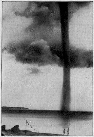
Waterspout off Rugen Island, Baltic Sea 1937

Waterspout off Rugen Island, Baltic Sea 1937

Waterspouts are (simplistically) tornadoes at sea, or on rivers and lakes. They have usually been regarded as curiosities of nature, because, unlike tornadoes, they do not often inconvenience the human race. Many waterspouts are feeble vortices which probably could not even come into existence in the turbulent air over the land, but they should not be taken lightly. Spouts have crossed onto land and become tornadoes, and some are tornadoes which have passed onto water. Even spouts far out in the ocean can be of tornadic size and power.

'Waterspout' is a rather inappropriate name, since spouts consist almost entirely of whirling cloud, with a plume of spray (the cascade) at the surface whipped up by the vortex as it touches the water. They do illustrate the difficulty of studying natural phenomena in the days before video and photography. Spouts could not be predicted, captured, or studied at leisure. Any student of waterspouts would have to rely on the accounts of people who had seen one, and they were not seen very often. They didn't even leave any physical traces unless they came ashore, which was an even rarer event. This is why the idea that spouts were literally waterspouts, streams of water pouring from the clouds (and raising spray when they hit the sea) lasted so long. An 18th Century scientist, defending the stream-of-water theory, even said, "the wonderful catalogue of nature needed not whirlwind-waterspouts to increase the number."

Waterspouts are whirlwinds, of course (something the Roman poet Lucretius knew), but it seems that powerful spouts can carry large amounts of water in the lower parts of their vortex. Some even lift water into their parent cloud, as shown by falls of salt rain after the spout has dissipated. Waterspouts are usually held responsible for the mysterious falls of fish and other aquatic animals. There are difficulties with this theory, but nobody has yet come up with a better one.

The chronology of remarkable waterspouts below is not inclusive. Many unusual spouts have had to be left out due to lack of space.

MARITIME NOTES:

Riverdance ferry will not be cut up - salvors


Riverdance


REFLOATING
the stricken Blackpool ferry will be later rather than sooner. The Riverdance does not look set to move until towards the end of the two weeks salvors described as "a window of opportunity".

Weather has played a part in hampering efforts to right the 6,000-ton vessel, which has been stuck on the beach near Anchorsholme Park since the start of February.

View our Shipwreck online special

See The Riverdance webcam

See our Riverdance picture gallery - updated daily

Salvage crews said there was a chance to move the ship sometime between now and March 13, but they say this is most likely to happen towards the end of this period.


Coastguard bosses insist the plan is still to right and then refloat the Riverdance – denying rumours that the move would be impossible and salvors would have to cut it up.

Oil Tanker Towed to Dock After SOS Call

YANBU, 6 March 2008 — An oil tanker carrying one million barrels of crude sent out a distress signal and was towed back to the King Fahd Industrial Port in Yanbu.

The ship, which reported engine failure about 200 kilometers from the port, arrived back at the port yesterday, officials told Arab News.

“KFIP’s emergency operation’s team rescued the oil tanker meandering amid the coral reefs following engine failure off the Duba coast,” Hammoud Al-Saadi, director general of the port, told Arab News yesterday.

Venture Navigation Co., Ltd. of Greece owns the 20-year-old Dominican-registered ship, according to Lloyd’s Registry. The ship was destined for the port of Aqaba, Jordan.

The distress call said the ship’s engines had broken down and was floating with the currents about 200 kilometers from Yanbu.

The rescue team found the captain of the ship steering without power as the weather was turning nasty. No injuries were reported.

“The successful operation averted a shipwreck and a major environmental disaster. The tanker was floating at an area close to virgin coral reefs. Any leakage of the ship’s load would have devastated the reefs,” Al-Saadi said.

Desalination plants in nearby Duba would have been affected by an oil spill, the port official added.

“Three powerful towboats struggled for 48 hours to bring the loaded tanker safely to the dock in Yanbu,” he said.

Oil from the Eastern Province is piped across the Kingdom for export from this northwestern port city. The western coast of Saudi Arabia is a maze of coral heads that can potentially damage and sink sea vessels. An accident involving a full oil tanker colliding with these underwater columns has a potential to cause a major environmental disaster.


RS

Friday, February 29, 2008

Winter Weather Research at the National Severe Storms Laboratory

Improving understanding and forecasts of hazardous winter storms

NSSL (NOAA Severe Storm Laboratory) is about more than just tornadoes and thunderstorms--we are also a focal point for National Oceanic and Atmospheric Administration (NOAA) research on hazardous winter weather.


In addition to conducting research on convective storms, NSSL scientists study blizzards, freezing precipitation, and heavy snow. Radar research and development efforts also are being conducted to improve the discrimination of rain from snow, the quantitative measurements of snowfall, and the small-scale structure of winter-weather system

The Intermountain Precipitation Experiment (IPEX)

IPEX is a research program designed to improve the understanding, analysis, and prediction of precipitation and precipitation processes in the mountains of the western United States. Over 30 scientists from NOAA and the Universities of Utah, Oklahoma, and Nevada collected data in February 2000 using research aircraft, mobile radars, and weather balloons. Analysis and interpretation of this data will allow project scientists to examine the factors controlling the distribution and intensity of snow across narrow, steeply sloped mountain ranges like the Wasatch Mountains.

PAYOFF: The knowledge gained through analysis of IPEX datasets conducted by NSSL scientists will lead to better forecasts of deadly winter storms in the western United States

MORE INFORMATION:
http://www.nssl.noaa.gov/teams/ipex/

Precipitation Type

Predicting the type of precipitation (rain, snow, freezing rain, or sleet) can be a difficult forecast challenge. A first step in such predictions is understanding the climatological distribution of precipitation type. NSSL scientists are working with collaborators at the National Center for Atmospheric Research, Environment Canada, and the University of Oklahoma to compile such information for North America. The next step to improve forecasts is to develop algorithms for the prediction of precipitation type. The goal of the Precipitation-Type Algorithm Experiment (PTAX) is to determine the quality of existing algorithms and investigate ways to display the results using probabilities. Other research at NSSL showed the importance of falling snow melting aloft to changing the precipitation type observed at the surface.

PAYOFF: Better information will help forecasters provide more accurate warnings for freezing rain, sleet, and snow.

MORE INFORMATION: http://www.cimms.ou.edu/~cortinas/preprints/avi09/9aviation.html
http://www.spc.noaa.gov/exper/ptax/

Winter Lightning

Lightning is not restricted to summertime thunderstorms--sometimes snowstorms can produce lightning as well. NSSL scientists have produced maps of wintertime thunderstorms across the United States that show these storms occur most frequently in the Great Plains. Another study provides guidance for forecasters in Buffalo and Salt Lake City for determining the occurrence of lightning associated with lake-effect snowstorms in their localities. Finally, during IPEX, NSSL scientists and their collaborators obtained the first measurements of the electric field inside winter storms over the United States.

PAYOFF: This research will improve the fundamental understanding of conditions that cause wintertime lightning.

MORE INFORMATION:
http://www.nssl.noaa.gov/mag/network.shtml

Banded Precipitation Studies

When precipitation appears as organized bands on radar, accumulation at the surface can be extreme. Researchers are looking at conditional symmetric instability and frontogenesis as predictors of banded precipitation. Other studies have shown that small-scale circulations in winter precipitation can sometimes be similar to supercell thunderstorms.

PAYOFF: Studies of banded precipitation ultimately result in better mesoscale forecasts, traveler's advisories, and other detailed forecast products used by schools, businesses, transportation systems and local governments.

MORE INFORMATION: http://www.nssl.noaa.gov/csi/

Improving WSR-88D Snowfall Estimates

Data from IPEX and previous winter storm studies in the mountains of northern Utah are being used to calibrate the nearby WSR-88D. A special network of snow gauges provides snow water equivalent measurements that are used to determine correction factors for remote radar precipitation estimates.

PAYOFF: More accurate radar precipitation estimates provide forecasters with better real-time water-equivalent snowfall rates. In addition, hydrologists and water managers (e.g., reservoir operators) have more accurate knowledge of potential snow melt run-off.

Shelf Ice

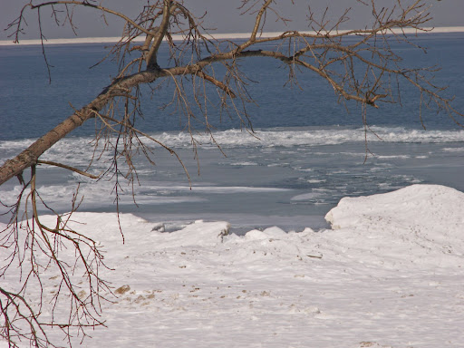
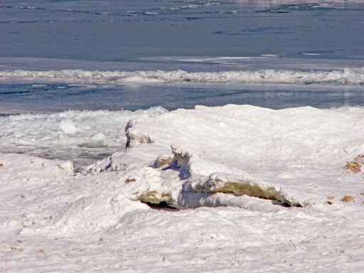
These pix's were taken at
Indiana Dunes National Lakeshore Park. Shelf Ice is a beautiful thing but extremely dangerous because of its stability or lack thereof. How a look of beauty can be so very deceiving.


TWISTER NEWS -
March 1st is here!
The Chase begins!


FEMA specialists offer help to rebuild more safely after tornadoes

FEMA hazard mitigation specialists will be at local building supply stores today through Saturday with information to help residents rebuild more safely and stronger following the severe weather of Feb. 5. (Story)


Survey Teams Confirm 3 Tornadoes in Tuesday Storms

Survey crews confirmed three tornadoes touched down early Tuesday. All were classified as E-F-One.


Tornadoes and straight line winds were blamed for causing thousands of dollars in damages in Leeds, the Pell City/Cropwell areas, Highland Lakes in northern Shelby County, northeast Talladega County and southern Calhoun County.


In Leeds, an elderly woman was killed when a tree fell on a mobile home.


Meteorologists said aerial and ground surveys determined that dozens of homes and businesses in the affected counties suffered minor to major damage.


An E-F-One tornado can generate wind speeds of between 86 to 110 miles per hour.


Forecasters say no severe weather is expected for the remainder of the week.


Houston EMA Chief Questions Siren Use

By: Lorra Lynch


Perry's fire chief turned on the tornado sirens during Tuesday's threat of severe thunderstorms. The sirens caused many people to believe there was a tornado warning.

Houston County EMA Director Jimmy Williams says he's concerned about the decision to activate sirens in Perry during Tuesday's severe weather.

Williams says Chief Joel Gray's decision to turn on the sirens to alert people about the threat of severe thunderstorms instead of tornados caused a flood of calls to the E-911 center. He called the volume of calls "very disruptive."

Chief Gray said he activates the sirens during any severe weather or homeland security threat. He said he's going by FEMA guidelines, and plans to stick with the policy until he's told to do otherwise by city management.

Williams met with Houston County Commission Chair Ned Sanders about the issue Wednesday morning. He says they plan to schedule meetings on the use of the sirens as soon as possible.

The City of Perry and Robins Air Force Base are the only areas in Houston County with access to tornado sirens.


MARITIME NOTES

UK. RNLI heroes & Coast Guard heroes honoured for MV Ice Prince rescue, read the dramatic story


The Coxswain of the Torbay RNLI lifeboat, Mark Criddle, is to be honoured by the Royal National Lifeboat Institution as the charity awards him the Silver Medal for Gallantry, recognising him for his leadership and outstanding seamanship during the rescue of eight seamen from the stricken merchant vessel Ice Prince on the night of 13 January 2008.


Coxswain Criddle’s volunteer crew on that night – Deputy Second Coxswain Roger Good, Deputy Second Coxswain John Ashford, Mechanic Mathew Tyler, Second Mechanic Nigel Coulton and Crew Members Darryll Farley and Alex Rowe – have also be recognised for their bravery and will each receive the Thanks of the Institution inscribed on Vellum.
Ice Prince with 20 crew on board was on passage 34 miles south east of Berry Head, Devon when severe gale force 9 winds and rough seas shifted its cargo of timber causing the vessel to list 25 degrees to port. (Story)

Riverdance ferry "can be righted"

By
Lisa Ettridger

BAD weather is continuing to takes its toll on the stricken ferry Riverdance – but rumours that the ship will have to be broken up and removed have been dismissed.

Officials from the Maritime and Coastguard Agency (MCA) say a 40ft diameter box which provided accommodation for drivers will be dug up from the sands at Cleveleys after falling into the sea in bad weather earlier this week.

"It's part of the accommodation, where the lorry drivers would sit to have a cup of tea," said Richard Skeats of the MCA.


Nautical Anchor


Messing About In Ships Podcast #12 - Special Interview of US Coast Guard Rescue of Sailors Aboard the Yacht Sean Seymour II

February 25, 2008, 4:33 am
Filed under: podcast, shownotes

Speaking of "winter weather"... Have a great weekend!
RS

Tuesday, February 26, 2008

New Radar Technology Can Increase Tornado Warning Lead Times

Navy's phased array radar being adapted for weather use

A National Weather Radar Testbed has been established at the National Oceanic and Atmospheric Administration's National Severe Storms Laboratory to provide the meteorological research community with the first surveillance phased array radar facility available on a full-time basis.

Norman is already known as a national center for weather radar research and development. NSSL's research in Doppler radar led to one of the most successful and significant technology advancements since the launching of the first weather satellite.

Nearly 30 years ago, NSSL was a major participant in the development of Doppler technology that became the heart of the WSR-88D radar, or NEXRAD.

The deployment of a system of 120 NEXRAD radars across the United States was the cornerstone of the modernization of the National Weather Service.

Installation of the SPY-1A antenna and radome on the NWRT

Navy supply ship showing SPY-1 radar that is currently used to support tactical operations.

Phased array radar is currently used on Navy ships to support tactical operations.

Phased array radar technology may help forecasters of the future provide earlier warnings for tornadoes and other types of severe and hazardous weather. Researchers are adapting the SPY-1 radar technology, developed by Lockheed Martin to support tactical operations aboard Navy ships, to weather detection. The phased array radar project has begun a new stage in NSSL's leadership in the research and development of future generations of weather radar.

Research Partnerships

A unique federal, private, state and academic partnership is developing the phased array radar technology. Participants include NOAA's National Severe Storms Laboratory and National Weather Service Radar Operations Center, Lockheed Martin, U.S. Navy, University of Oklahoma's School of Meteorology and School of Electrical and Computer Engineering, Oklahoma State Regents for Higher Education, the Federal Aviation Administration, and Basic Commerce and Industries. The project - from research and development to technology transfer and deployment throughout the U.S. - is expected to take 10 to 15 years at an initial cost of approximately $25 million for the facility in Norman.

Promising New Radar Technology

Early tests of the phased array radar system show that the technology has the potential to vastly improve upon the capabilities of the national NEXRAD radar network for all weather radar applications. Using multiple beams and frequencies, phased array radar reduces the scan time of weather from five or six minutes for NEXRAD radar to less than one minute, producing fast updates of weather data.

The National Weather Radar Testbed allows NSSL and other meteorologists to determine if phased array radar will become the next significant technology advancement to improve our nation's weather services.

Schematic shows how the radar might scan storms as well as clear air, and also track aircraft and uncooperating targets.

The rapid scanning ability of phased array radar gives it the potential to be a multi-use, adaptively scanning radar.

Improved Warning Lead Time

In addition to faster updates, the new system can scan the atmosphere with more detail at lower elevations than current radar allows. It can also re-scan areas of severe weather very quickly, potentially increasing forecasters' warning lead times as storms rapidly transition to severe modes.

PAYOFF: This technology has the potential to increase the average lead time for tornado warnings well beyond the current average of 11 minutes. Other technology being developed at NSSL will extend lead times even farther.

Improved Understanding and Forecasts

The new technology will gather storm information not currently available, such as rapid changes in wind fields, to provide more thorough understanding of storm evolution. Researchers and forecasters can then improve conceptual storm models and use that knowledge to evaluate and improve stormscale computer models. The data will also be used to initialize computer models and improve forecasts.

PAYOFF: Phased array technology will increase fundamental understanding of storm evolution, in turn leading to improved computer models, more accurate forecasts and earlier warnings.

Reflectivity display from first tornado captured by the NWRTVelocity display from the first tornadic storm captured by the NWRT
Reflectivity and velocity displays of the first tornadic storm captured with the NWRT

NSSL RADAR RESEARCH

WSR-88D Improvements
  • Implementing range and velocity ambiguity mitigation techniques in the WSR-88D radar network will result in an improved ability for the WSR-88D to detect severe weather, flash floods, winter storms, and provide aviation forecasts.
  • An increased ability to identify aviation weather hazards and to track, classify and identify aircraft will improve airline safety and help fill gaps in homeland security.
Phased Array Radar
  • Phased array technology could significantly extend warning lead times, increase accuracy, and reduce the uncertainty of predicting severe weather events.
  • Adapting phased array technology to both weather observation and aircraft surveillance will provide significant cost benefits and a higher level of security to the nation
Real-time Applications
  • Researching and prototyping new severe weather warning applications using WDSS-II multi-sensor technology will help fast-track improvements into operations and provide a robust decision support system for forecasters.
Testbeds
  • The National Weather Radar Testbed at NSSL will shorten the cycle time from weather radar research to National Weather Service operations, leading to increased accuracy and lead-times, and reducing the uncertainty of predicting severe weather events.
  • A cost-effective network of many small radars that can scan lower regions of the atmosphere will provide better weather coverage in high population or weather-sensitive areas.
Mobile Doppler Radars NSSL PODCAST - Radar Research

National Severe Storms Laboratory Chief of Radar Research and Development Doug Forsyth discusses aspects of radar research and what’s in store for the next generation of weather radar. Recorded 8 November 2007

  • Section 1 - Types of radar research done at NSSL (5:43)
  • Section 2 - Transition of research to operations for new radar applications (3:11)
  • Section 3 - Doppler radar and new radar technologies being researched and how they compare (8:39)
  • Section 4 - Advantages of collaborative radar research (3:24)
  • Section 5 - Doug discusses his career and his advice for people considering a career in the atmospheric sciences (6:09)

headphonesLISTEN TO THE COMPLETE PODCAST RUNTIME 27:08 TEXT TRANSCRIPT


BE READY CAMPAIGN

Tennessee Severe Weather Awareness Week: Feb. 24-29

The National Weather Service, the Tennessee Emergency Management Agency and other supporting organizations are working together to help in providing the public with information about severe weather safety. Advance planning and increased awareness will help Tennesseans survive these deadly storms. Governor Phil Bredesen has proclaimed February 24-29, 2008, as "Severe Weather Awareness Week" in Tennessee.As we move into our Spring, now is the time to prepare ourselves for the hazards and dangers associated with severe weather. Severe weather can and does occur any time of the day and anytime during the year. Are you prepared?

Click on the link to download the booklet. Severe Weather Awareness Week Booklet 2008

MS Severe Weather Awareness Week
Sunday, Feb 24, 2008 - 10:30 PM
By AnneMarie Crumby
Governor Haley Barbour declares this week Severe Weather Awareness Week in Mississippi. The National Weather Service will issue a statewide test tornado warning on NOAA Weather Radios Wednesday morning.Schools, government agencies and businesses throughout the state are encouraged to participate in a tornado drill. Everyone is asked to buy a NOAA Weather Radio. It sounds an alarm when local severe weather watches and warnings are issued. These radios range in price from $30 to $70.

Emergency Management Looking for Severe Weather Spotters

Towson, Md. (February 7, 2008) – Local weather buffs have an opportunity to put their interest in meteorology to valuable practical use.

The Baltimore County Office of Homeland Security and Emergency Management is recruiting volunteers to help spot severe weather. The volunteers would be part of SKYWARN, a national network of amateur severe weather spotters, trained by the National Weather Service to spot severe thunderstorms, tornadoes, hail and flooding, snowfall and ice accumulation.

Along with the National Weather Service, the Office of Emergency Management will sponsor a SKYWARN and Spotter Class on Tuesday, March 11, 2008, 7 to 10 p.m., at the Baltimore County Public Safety Building, 700 E. Joppa Rd., Towson. The class will be held in the 6th floor conference room.

The class is free of charge

To register, email tbrush@baltimorecountymd.gov, or call the Office of Homeland Security and Emergency Management at 410-887-5996.

INTERNATIONAL WEATHER
By Arthur Rabjohn CEM

ENGLAND: Council flood funding payments exceed £15million Floods Recovery Minister John Healey today announced over £2.5million funding for six authorities across the country, to help them get back on their feet following last summer's floods. This means that over £15million has now been paid out under the Bellwin scheme, which covers costs incurred by local authorities during immediate action to safeguard residents and property or prevent suffering as a result of a disaster or emergency. This money is on top of up to £63million of other Government support made available to help flood-hit communities. FULL ITEM AT: http://www.communities.gov.uk/news/corporate/703254?version=1

USA: Night of Texas Wild Fires followed by fog chaos. Closure of Houston Hobby Airport led to major disruption as a result of dense fog. Planes were diverted to other airports, mainly DFW, and passengers sat on the tarmac for over two hours in some cases. Following a night of wildfires was there a connection?

NAMIBIA: Emergency Management Gets Blasting Omusati Governor Sackey Kayone has criticised the Regional Emergency Management Unit (REMU) for lack of means to respond to emergency situations. In a speech delivered on his behalf by Outapi Councillor Simon Shileka, he expressed reservations with the way finance is centralized at the expense of regional emergency units. MORE AT: http://allafrica.com/stories/200802251264.html

INDONESIA: A powerful earthquake hit off the coast of Indonesia's Sumatra island. The quake was centered about 160km south-southwest of Padang and had a magnitude of 7.3, and occurred at about 10km beneath the seabed. There are no reports of casualties or damage. A local tsunami watch has been issued and lifted after.

CHINA: China has forecast heavy snow and blizzards across its industrial and agricultural heartland over the next three days. At least 129 people have died. Transport is in chaos and cut off power and water appeared. Severe weather damaged millions of hectares of crops and killed more than 70 million animals. Snow and sleet would hit six provinces spanning China's central, eastern and northern regions. Blizzards were also expected in the northwestern part of central Hubei province, already plagued by winter storms earlier this month.

MADAGASCAR: Nearly 145,000 people have been left homeless by a cyclone that tore through Madagascar, killing 44 people. Cyclone Ivan struck the island's east coast last Sunday, and was followed by torrential rains which caused flooding. Winds gusting at more than 230km/h caused widespread damage. Infectious diseases such as diarrhoea are reported to be on the rise. The cyclone season is not expected to end until April, so the government has warned that further storms could follow.

ECUADOR: Persistent rains and floods have left Ecuador in a state of disaster as concern aver food shortages grows. Rains and swollen rivers have caused flooding in 13 of the country's 24 provinces, destroying homes, crops and infrastructure. At least 300,000 people have been affected, including 20,000 evacuated. 110,000 hectares of crops, including rice, coffee, corn, banana, cacao and sugar cane have been destroyed. A national emergency has been declared. EU MIC is monitoring the situation.

MARITIME NOTES:

Lack of talent blamed for shipping accidents
By Nadim Kawach on Sunday, February 24 , 2008


Shipping accidents have increased sharply worldwide over the past few years because of the introduction of complex systems and a lack of experienced crew abroad vessels, according to a specialised organisation.

The surge in accidents has boosted business at shipping yards and consequently pushed up the cost of vessel repair and maintenance, the Singapore-based DNV company said in a report sent to Emirates Business.


“Updated figures for 2007 show that the losses from navigational accidents within the shipping industry are continuing to increase. This trend was also confirmed by the insurance industry. Premiums may increase by as much as 30 per cent in 2008,” DNV said in the report, presented at a shipping conference yesterday.


“DNV monitors the frequency of serious accidents. Over the past five years, there has been an increasing incidence of serious navigational accidents in several shipping segments. This increase is confirmed by many insurance companies such as Skuld, Norwegian Hull Club and The Swedish Club,” said DNV, which covers a wide range of services including classification, certification, consulting, training, asset operations, verification, laboratory testing and technology qualification.


In addition to the increasing frequency of navigational accidents, the cost of each repair caused is rising.


The yards are overbooked, making it hard to find a repair slot, resulting in increased prices for firms. Collisions, groundings and contacts now account for 60 per cent of the most expensive accidents.


The report quoted Torkel Soma, principal safety consultant at DNV Maritime, as saying: “DNV’s statistics show a ship is twice as likely to be involved in a serious grounding, collision or contact accident today compared to only five years ago. In addition, estimates show the cost of these accidents has doubled. Since this is the general trend for the international commercial fleet, the maritime industry needs to act on this immediately.”


According to the report, the boom in the shipping market and increased deliveries of new ships have resulted in pressure on crews.


It says the shortage of officers has resulted in lower retention and faster promotion, adding that as a result, the general level of experience is decreasing on board. At the same time new technical solutions have also been introduced, which might have increased the complexity of operations.


“Reliable technology and complying manuals are no assurance against making errors. Collisions, groundings and contact accidents do almost always involve human acts,” Soma says.


Helge Kjeøy, regional manager DNV Maritime South East Asia, said: “The main factor explaining the negative developments over the past few years is the undersupply of crew worldwide. This results in reduced experience and the high commercial pressure results in high workload. Adding new and more complex equipment does not only help the situation. Avoiding accidents under such situations requires a good safety culture, something which the maritime industry evidently needs to focus more on.”


The experience of leading shipping companies shows the focus has to be turned more in the direction of human elements and organisational factors, including all those involved – from the directors of the company to the officers on the bridge.


Soma adds: “Safety improvements with reduced accident frequency have been achieved through a structured approach addressing behaviour and culture. For the industry to maintain its traditionally good track record, the resilience of operations has to be addressed on a larger scale.”


THE DNV REPORT

Singapore: Updated figures for 2007 show that the losses from navigational accident within the shipping industry are continuing to increase.


RS