Showing posts with label be ready. Show all posts

Wednesday, April 2, 2008

Calm after the storm

Calm after the storm

Tourism in Fiji was floored by the 2006 coup. But the island nation has plenty to offer and little to fear. Peter Bingham reports.

Fiji's greatest earner is on the ropes.

Tourism, which outstrips sugar cane production for income, is reeling from its third sucker punch in 20 years.

People from the main markets of Australia and New Zealand have stayed away in droves since the December, 2006 coup led by Colonel Frank Bainimarama.

It floored the industry after the governments of the trans-Tasman neighbours slapped grade one travel warnings on the island republic.

The flow of visitors from Australasia dried up overnight just as it did following the coups of 1987 (Sitiveni Rabuka) and 2000 (George Speight).

There are other pressing problems facing this interim regime such as corruption, drugs, street crime, roading, inflation and unemployment.

But tourism is its backbone and the industry is just staying afloat thanks to support from Europe, Asia, and the Americas.

Scraping itself back off the canvas is the Fiji Islands Visitors Bureau which has the job of getting Kiwis and Ockers back on its beaches.

And it has lofty aims.

"We have a target of 570,000 tourists in 2008 and we hope at least 100,000 of those will be Kiwis," Tom Valentine, the bureau's senior marketing officer, said.

"We have to be smart with our marketing. There is tough competition from our rivals in Indonesia, Singapore, Hong Kong and Thailand and our budget is minute compared to theirs."

By smart he means concentrating on things such as Fiji's allure as a wedding venue.

"That's a growth business. Someone gets married in Fiji every day and more and more tourists are tying the knot at our resorts or on our beaches."

Diving, water sports, cruising and backpacking are other top attractions.

The bureau was well aware of the dangers of dependence on Kiwis and Australians.

"We are always diversifying and can't rely on the golden goose to keep laying eggs. Recently Gordon Brown (England's new PM) agreed to wear a red flower behind his ear and appear on our advertising in London. We had huge hits on our website but their press took exception to their PM being involved in such a campaign and we had to stop."

You can't fault the optimism and enthusiasm of the bureau and inviting journalists over to view the state of the republic under military rule is part of the campaign.

Suva (Mr Bainimarama's base), was not part of the itinerary but there was no sign of the military anywhere else other than the Fiji Army's sevens team at a tournament in Nadi (they won it after a protest).

The first stop was two days at the Warwick Fiji Resort and Spa on the Coral Coast about midway between Nadi and Suva.

The second stint involved 48 hours on Tai (Beachcomber) Island and then two days on Denarau Island's Radisson resort.

WARWICK FIJI RESORT: A freak tidal surge caught the 250-room resort by surprise a few years ago sucking tables, chairs, fridges and other whiteware out to sea as the waters retreated.

"You should have seen them bobbing in the waves," long-time manager Jack Stark said.

"The electrical gear was ruined and the furniture "disappeared"; there were a few happy villagers I believe."

The quirk of nature didn't phase Stark. It just provided an opportunity to develop the vision he has for the resort.

"The waves smashed in to our southern end hardest and destroyed our store room. I'd been wanting to add a spa for some time so that's what we did."

This is a user-friendly resort. One wing is dedicated to family bookings and the other to adult visitors which provides welcome relief from the ankle biters. The same rules apply to the respective pools.

A wedding stopped plans for an evening meal in the Wicked Walu Restaurant, sitting atop an outcrop of rock and specialising in seafood.

Weddings are a big part of the Warwick's business. So much so that the guest pack itemises all costs from involved in tying the knot.

"Usually the biggest hiccup is couples forgetting to get a marriage licence. The office closes at 4.30pm on a Friday in Sigatoka and that's that ... no licence, no wedding.

"People see other couples getting married and want to do the same straight away," Mr Stark said.

Half an hour back down the road from the Warwick is the Kula Eco Park, Fiji's only wildlife sanctuary.

It was originally a bird park established in the 1980s but it was eventually abandoned and left in a shocking condition.

"We re-opened in 1997 with an elevated walkway and have built the park up to its current state over the past 10 years," co-owner Ramesh Chand said.

Iguana, falcon and ground frog breeding programmes are a key part of the park's business which employs 24 people.

"We are privately funded and have yet to break even but we see the park as a vital part of Fiji's education system," he said.

In their best year (2005), 40,000 people visited the park including 15,000 school children.

Illegal trade in iguana and native parrots was of concern.

"There is a case going on in Los Angeles now where a man is charged with illegally importing a pair of Fijian banded iguana with a street value of $30,000.

"We know locals have caught and traded native parrots for $100 each to passing yachties who resell them for much, much more. Fiji has no resources to control that so it is a concern."

The second tourist venue of the morning was Tavuni Fort Hill on the Sigatoka River.

It was the highly fortified settlement of Tongans who arrived on the island in the early 1800s.

It harbours the history of fierce tribal wars but lay overgrown for years once the Tongans were forced out by the British troops in 1876.

Clearing of the site began in the 1970s and once restoration was complete the fort was opened to the public in 1997.

Albert Kurivitu has been its guardian since clearing began and has a distinctive style as he tells tales of the site's bloody past.

"They were smart warriors and there were few ways to get in," he said.

"When the Fijian raiders came, many were caught and were dragged to the killing stone, held down, clubbed and carried off to be cooked and eaten."

Takeaways were born.

The killing stone remains although it mysteriously split in three once Christianity came to the island.

"Legend says it was God's way of showing the days of killing and cannibalism were over."

BEACHCOMBER ISLAND: I arrived late on this outcrop ... by about 30 years. This is the Ibiza of the South Pacific and I should have been wary when the ferry skipper announced it "was an island where the young go to get lucky". Comforting for a 54-year-old.

At first I thought I was at a conference of the illiterate.

A prominent sign clearly stated nude or topless bathing on the main beach was offensive to island staff.

Three girls couldn't read. But they could dance and were all go as the sun went down and the band tuned up.

An auction of hermit crabs for an "international" race was a highlight of the first night's entertainment and the only chance of a punt.

Marley of Jamaica won from Ronaldo of Brazil. Bruce Lee of China was scratched for wont of a bid and All Black of New Zealand (which I bought for $12) didn't get started just like in the World Cup.

This island offers cheap fare for the young tourists. Accommodation in a 90-bed dormitory goes for $88 a day which includes three meals-a-day and the food is outstanding. Drinks are extra.

This is definitely not the retreat for those in the health and safety game. The weekly visit of the supply freighter Kaiwai would have given them apoplexy.

There were the workers, unloading kegs, 44-gallon drums and other cargo in bare feet and baseball caps and not a missing digit to be seen. Even the tractor driver was shoe/bootless. What a refreshing sight.

RADISSON RESORT: Gate-controlled Denarau Island is home to a host of top-of-the-range resorts and the Radisson is as plush as they come and only three storeys.

Nothing in Fiji is more than three storeys because building law dictates no building can be higher than a mature coconut tree. I like that.

The bed in room 359 was as big as they come. You could lie crossways and still not touch the sides. Bit of a waste for a solo traveller, really.

The recreation area was massive with three pools and a shark-netted area for those preferring salt water.

But it was the Harmony Island section that intrigued me.

Not knowing quite what to expect, I ventured in and a very pleasant receptionist asked if I would like a look at one of the thatch roofed rooms.

The directions were unfortunately muddled in translation and I peeked in to an occupied unit much to the dismay of the occupant(s).

A very embarrassed Kiwi retreated to the bush with a brochure in hand.

This was a retreat to massaging bliss apparently and everything was itemised.

There was the basic 30-minute Harmony Island massage ($50), a stone massage which involved an hour of something, a four-hand massage and a massage for couples.

The last three set you back $190-apiece.

I was just sad I had run out of money.

The Radisson is directly opposite the 18th fairway of the Denarau Golf and Racquet Club, former home of the Fiji Open.

An early morning tee time was prearranged and I was joined by the only cluster of three Aussies encountered in three days.

They were good blokes, Damien (plumber), Shane (dairy farmer) and Mike (sales manager), but like me were bemused as to why Fiji re-routed its water system through the middle of the course.

In between more than a few birdies, pars, oaths and water-bound balls we did our bit for trans-Tasman relations and wondered why others from our countries took so much notice of government warnings. There is holiday danger because of the coup.

Peter Bingham travelled to Fiji courtesy of Air Pacific and the Fiji Islands Visitors Bureau.

WEATHER NOTE

Companies must plan for disasters

Dubai: The UAE's private sector needs risk assessment plans as companies need to be prepared for potential natural disasters among other risks and adopt international best practices, oficials say.

With the business continuity management system, companies will be able to assess their main operational areas, and plan and test necessary alternatives in case of disasters.

"Companies in UAE are aware of potential disasters but don't have actual plans in place," said Theuns Kotze, managing director for the Middle East and Africa, BSI, a management systems assessment services company, which is holding roadshows in the UAE this week.

Fragile

In a thriving economy such as Dubai, companies are dangerously unprepared for disaster. "A fast growing economy is fragile to potential disaster that can halt business. Companies here expect business to do well all the time, so they don't keep in mind that anything disastrous can happen," said Kotze, whose company will certify companies that have gone through the process of verified tests.

"An economy is only as strong as its ability to recover from disaster. If the companies are prepared, the economy will be prepared," Kotze said. "If companies struggle, the economy will struggle."

While natural disasters are hardly considered in Dubai, financial risks are very much assessed.

"A lot of companies are doing risk assessments as world prices go up," said Kotze. "Companies should not take risks that are not sustainable. Even if perfect alternatives cannot be found, companies need practical alternatives," he said.

The Northwest Indiana AMS/NWA Great Lakes Meteorology Conference

The 6th Annual Great Lakes Meteorology Conference will take place on April 5, 2008. It will be held at Old Town Banquet Center in Valparaiso, Indiana, and will feature keynote speaker Dr. Louis Uccellini, director of the NOAA National Centers for Environmental Prediction. Also speaking will be Dr. Jeff Trapp, Mike Umscheid, and Ginger Zee, among others.

REGISTRATION INFORMATION IS POSTED BELOW.

Doors open and registration will begin at 9 AM CST and the conference will officially begin at 10 AM CST. Continued

Watch for warning signs of severe weather

By Jim Nitz , Lincoln County Emergency Management Director

Once again, the severe weather season is approaching in Nebraska. While almost everyone is aware of the types of severe weather to be expected, there is a lot of information that people do not know, or tend to ignore, which can save your life in an emergency.

Almost everyone is familiar with the weather indicators which are indicative of pending severe weather; warm temperatures, high humidity and developing cumulus clouds indicating thunderstorm development with lightning. When these conditions are observed it is time to listen closely to the electronic media regarding weather conditions.

One of the best sources for information is a NOAA weather radio. With a NOAA radio, you can get weather forecasts as well as an alert tone if severe weather notices are issued 24-hours a day.

The National Weather Service office has back up generation capability to enable them to broadcast weather information to battery operated radios even if commercial power sources are interrupted. A complaint about the older style of NOAA radio was that it broadcast watches and warnings for the entire area covered by the local National Weather Service office whether your county was included in the watch/warning area or not.

The newer NOAA radios have a specific code built into them which allows you to receive only the watch/warning information issued for your county. And, NOAA radio can be used by Emergency Management to broadcast other emergency information that is not weather related. Severe weather forecasting has improved immensely over the past few years due to improved technology. Information now issued is very timely and forecasts indicate what time a storm could be entering your particular area and the severity of it allowing you and your family to take protective actions.

Watches
This is an awareness issue. When a severe weather watch is issued, it simply means that conditions are favorable for the development of severe weather in and close to the watch area. At this time, people need to check their emergency kit to and be prepared to move to a place of safety if threatening weather approaches.

Warnings
A warning is issued by the National Weather Service when radar, or a storm spotter, detects severe weather. Information in the warning will include the affected areas and the threats associated with the storm. Those in the warned area should seek shelter immediately. Last year, a severe thunderstorm drove hail through windows and across rooms in the Sutherland area. Severe thunderstorms can produce tornadoes with little or no warning. Occasionally, warnings can be issued without a watch already in effect. Warnings will be issued by the E911 center over cable television when received from the National Weather Service. But, depending on the age of your TV you may, or may not, receive them. This is due to a technical issue with the cable TV operator, not the E911 center. A NOAA weather radio is particularly important if you have satellite TV because you will not receive local warning information over satellite TV.

Sirens
There is misunderstanding as to what the sirens are supposed to accomplish. Most folks think the sirens are designed to wake them up out of a sound sleep in their homes. Depending upon the location of the siren and the direction and speed of the wind that may happen. But, the fact is the sirens are designed to alert people who are outside that something is occurring and that they should go inside and listen to the media for information. Federal law limits the audio output of sirens so that they don’t damage the hearing of those very close to them. While most people want to hear the sirens, the problem becomes one of “NIMBY”.

In other words, we need sirens, but “Not In My Back Yard”. A few years ago, the city of North Platte moved some sirens in order to provide more effective coverage of some areas of the city. All areas of the city are covered by at least one siren. Most areas are covered by two sirens that overlap the coverage area. And this does not include the sirens at Bailey Yard. Each siren covers an area of three square miles. In North Platte, a policy has been in effect for a number of years that sirens will be sounded if a tornado is approaching the city and gets within five miles of the city. This policy also applies to the Lake Maloney area for which the E911 Center controls the sirens.

MARITIME NOTES

Stricken cargo vessel off Esperance
31st March 2008, 15:30 WST

A Bahamas registered cargo ship is sitting 150 nautical miles off the Esperance coast after a fire forced it to shut down its engines.

Emergency services crews in Esperance are on standby while they wait to hear whether an evacuation or rescue is required.

The vessel, MSC Lugano, reported the fire to the Australian Maritime Safety Authority at 12.30pm today sparking an emergency response that included a search and rescue aircraft being sent from Perth to monitor the vessel.

A spokesperson for AMSA said the fire has been extinguished and the vessel's master was waiting for the engines to cool before the extent of the damaged could be assessed.

The spokesperson said none of the 25 crew had been injured in the fire and the ship was expected to restart its engines later this evening or by tomorrow.

"There are no pollution issues, the vessel is at anchor and not drifting, it is not sitting in any shipping lanes and no one is injured," the AMSA spokesperson told the west.com.au.

The 35958 tonne ship was travelling from Adelaide and Fremantle when the fire started.

JANE HAMMOND

RS

Tuesday, April 1, 2008

A paper worth reading!

Information Seeking Behavior and Viewpoints of Emergency Preparedness and management professionals concerned with Health and Medicine

Final Report

Prepared for the National Library of Medicine

By Murray Turoff and Starr Roxanne Hiltz

March 6, 2008

Executive Summary

A study for the National Library of Medicine (NLM) was conducted to assess the information requirements for health-related issues in emergency preparedness and response. The overall goal of the study was to identify the views of potential users about the most significant knowledge, information, and services they are seeking, some of which might be incorporated into the development of the Disaster Information Management Research Center (DIMRC) planned by the National Library of Medicine or into other related efforts.

The emphasis of the study was on determining the current information seeking behavior, existing preferred sources of information, and unmet information needs of professionals involved with the medical and public health aspects of emergency planning, preparedness, and response. The report summarizes responses to questions around the following topics: current sources, desired sources, organizing the information, examples of important materials and missing materials on the Web, librarian roles, information needs in extreme events, methods for dealing with information overload and organizing information, international issues, and level of experience with NLM resources. Detailed appendices include examples of grass roots efforts to mitigate information overload, a copy of the self report guide, a complete compilation of responses organized by type of respondent, and a list of international websites compiled by one of the respondents.

The study results address a full range of information needs, including the formal published literature, comprehensive databases for the management of specific types of disasters, practice-based documents that are typical of the gray literature, aids to developing and maintaining practitioner documents, and improved methods of organizing information of all types. Roles for librarians as well as disaster community experts were identified for enhancing access to important information at the time it is needed. Continued

Elementary Students Prepare for Weather Disasters

Severe weather season will soon be upon us and kids in the Kearney area will soon be a little more prepared to plan for it.

The Kearney Fire Department's safety trailer was on hand today as students from Bryant Elementary learned about severe weather. Firefighters taught students what to do when a tornado strikes as well as how to plan for a weather disaster.

The trailer will visit every school in Kearney before severe weather week April 5th through the 9th.

Disasters - Preparedness and Mitigation in the Americas Mar 2008

Peru Rebuilds Health Services Affected by the 2007 Earthquake

PAHO/WHO, with the support of the Spanish Agency for International Cooperation (AECID) and the Swedish International Development Cooperation Agency (SIDA), are supporting Peru's Ministry of Health and regional authorities with the health needs resulting from the earthquake of 15 August 2007 in Ica.

The project encompasses the construction of a maternal and child center in Pisco; recovery of services in the primary health network of Ica and Huancavelica; strengthening technical capacity for the epidemiologic surveillance system; improving the regional public health laboratory; and increasing coordination for disaster and emergency response among different sectors at the national, regional, and local levels by setting up Emergency Operations Centers and developing technical capacity.

The 7.9 magnitude earthquake, which affected several provinces, killing 519 people, injuring 1,366, and affecting 863,597 people. The public and social security health networks suffered considerable damage. According to official reports, 11 facilities were completely destroyed and 111 suffered different levels of damage. The 110-bed San Juan de Dios hospital was the most severely impacted. In addition to the health services, Pisco's water and sewerage systems were severely affected. There are major diffi culties in the process of latrine construction and supply of safe water, both in terms of quantity and quality. The management of solid waste, surveillance of food management, and proliferation of harmful fauna continue to be matters of concern.

For more information on progress in restoring health services in this area, contact Dr. José Luis Zeballos,at jzeballo@per.ops-oms.org.

Yellow Fever Outbreaks in the Americas

Yellow fever, commonly found in the tropical regions of South America and Africa, has two epidemiological cycles: jungle and urban. In the jungle cycle, the virus circulates in the primate population and humans are infected when they enter the jungle and are bitten by infected mosquitoes. Urban yellow fever was eradicated from the Americas (the last cases occurred in 1942 in Brazil). In mid-January of this year, Paraguayan health authorities detected an outbreak of jungle yellow fever.

The clinical manifestations of yellow fever virus infection are acute fever and jaundice (yellowing of the skin and eyes), followed by hemorrhage in 15% to 25% of infected patients. Case fatality can reach 50%.

Since the 1970s jungle yellow fever cases were limited to the northern region of South America. Between 1985 and December 2007, a total of 3,837 cases of jungle yellow fever and 2,229 deaths were reported.

In 2007 and at the beginning of 2008, six states in Brazil (Goias, Federal District, Mato Grosso do Sul, Minas Gerais, Tocantins, and São Paulo) recorded an intense and extensive increase in epizootic yellow fever. These outbreaks of the disease in animal populations were confirmed by laboratory and/or by clinical-epidemiological criteria through the State Health Secretariats. In January and February 2008, human cases were reported in three states (Goias, Mato Grosso do Sul, and the Federal District); of the 26 confirmed cases, there were 13 deaths. While the affected areas have high vaccination coverage, health authorities intensified vaccination campaigns for individuals over six months of age who had not been immunized previously and/or reside in/or frequent affected areas.

As of 21 February 2008, seven cases of yellow fever had been confirmed in Paraguay, all inthe rural area of San Pedro Department, about 300 km northeast of Asunción, the capital. Five other suspected cases were reported in Central Department, which neighbors Asunción; four of these cases died with signs and symptoms highly suggestive of yellow fever. If these cases are confirmed, it would validate the circulation of the virus in urban areas.

In response to these outbreaks, the authorities have expanded epidemiologic surveillance for the detection and testing of suspected cases. Yellow fever vaccination has been intensified in Asunción, Central and San Pedro departments, and in border areas in order to protect the population living in high-risk areas.

To achieve this level of coverage, approximately 3 million doses of vaccine are needed. Thanks to the support of PAHO/WHO, 850,000 doses are being sent from Brazil, 144,000 from Peru, and 2 million doses from the WHO Global Fund. With the support of the Spanish Agency for International Cooperation (AECID), the U.S. Office of Foreign Disaster Assistance (OFDA/USAID), and the Government of Italy, PAHO/ WHO has been able to implement emergency projects to intensify epidemiologic surveillance and vector control, increase laboratory diagnosis, expand communications about the risk, and carry out vaccinations in at-risk areas.

In Argentina, authorities reported that on 17 January 2008 dead monkeys were found in Piñalito park, in the department of San Pedro, province of Misiones. In February, yellow fever was confirmed in one of the primates through molecular techniques. Despite the high vaccination coverage in the area, authorities have intensified vaccination activities for previously unimmunized individuals who reside in or travel to the area.

Currently, the recommended yellow fever vaccination strategy is to direct efforts at the population that lives in, or is traveling to the areas where epizootics or human cases were recently registered and where risk of transmission exists. This approach avoids indiscriminate mass vaccination or revaccination.

PAHO/WHO is providing technical support through advisers from country offices and headquarters, in accordance with requests from the countries.

For more information, write to ugarteci@paho.org. In addition, the publications Control of Yellow Fever—Field Guide and Zoonoses and Communicable Diseases Common to Man and Animal, 3rd edition, can be consulted at http://publications.paho.org.

Floods: History Repeats Itself in Bolivia

The heavy rains produced by the La Niña phenomenon have left nine Bolivian departments under water. Flooding in Beni, Chuquisaca, Cochabamba, La Paz, Oruro, Pando, Potosí, Santa Cruz, and Tarija have affected 73,776 families and caused 63 deaths. The most affected areas are Trinidad, capital of the department of Beni (with 20,000 affected families) and the department of Santa Cruz (19,818 affected).

The floods reveal once more how vulnerable the population is to chronic hydrometeorologic disasters. There continue to be deficiencies in managing nutritional requirements and shelters and in gathering health information in remote areas.

Since November 2007, Bolivia has suffered from climatological phenomena that, according to experts, are more severe than those caused by El Niño at the beginning of 2007. The World Food Program (WFP) has reported that 80% of the people who suffered from floods in early 2007, suffered again with the recent heavy rains. The flooding has increased the risk of epidemics and there have been reports of cases of dengue, yellow fever, hemorrhagic dengue, hanta virus, malaria, conjunctivitis, diarrheal diseases, leptospirosis, and respiratory diseases.

PAHO/WHO has concentrated its efforts on coordinating disaster response in the areas of international cooperation, epidemiologic surveillance, vector control, mental health care, logistical support, and resource mobilization.

For more information, write to cgarzon@ecu.ops-oms.org

Investigating Weather Systems in the Montessori Classroom

North Carolina is in a severe drought. Currently, we are short approximately 10.5 inches of rain for the past two years. Severe water restrictions are in effect and hearing that neighboring towns have less than 100 days of water left is a frequent occurrence. That being said, we are entering our rainy spring season which also brings months of tornado warnings. Naturally curious, children want to know what causes weather, especially severe weather.

The Montessori classroom is a great place for children to learn, explore, and research naturally occurring phenomenon such as thunderstorms, hurricanes, and tornados. These concepts are usually introduced during the upper elementary years. Here, in North Carolina, we experience both hurricanes and tornados and this is enough to spur discussion and interest. If you live someplace where these weather systems do not occur, you can peak student interest by announcing that there are approximately 40,000 thunderstorms around the globe each day and that the class will have an opportunity to investigate how thunderstorms, hurricanes, and tornados form.

Before presenting these lessons to the children, it is important to have illustrative charts made of sea and land breezes, cold fronts, and warm fronts, as well as a map of high and low pressure systems and a variety of photographs (or video) of thunderstorms, hurricanes, and tornados. There is also a variety of vocabulary that needs to be explained before children can begin their investigations.

  • Sea breeze
  • Land breeze
  • Cold front
  • Warm front
  • High pressure system
  • Low pressure system
  • Convection
  • Coriolis effect

It may be helpful to watch the weather reports together over a period of several days in order to discuss and understand the terminology. You might also gather the weather report over a period of about two weeks and make predictions as a class as to what weather will be developing.

For more information for teachers, visit the National Hurricane Center website.

For informative, interactive games for students, visit Federal Emergency Management Agency website.

NAMC’s Upper Elementary Physical Geography curriculum manual provides background information and presentations on many weather related topics, including: Weather Systems and Weather Maps, Investigating Hurricanes and Thunderstorms, and Investigating Cold and Warm Fronts.

By AMANDA PODGORNY

When disaster strikes, strike back.

Preparing yourself for a natural disaster is not as difficult as it may seem.

Rich Gallati, operations manager for the DeKalb chapter of the American Red Cross, said there are three actions to take to be prepared for an emergency.

“What we’d recommend is to first get a first–aid kit and some first–aid training,” Gallati said. “Second, make an evacuation plan from where you are working or living, and the third step is to be informed.”


The American Red Cross offers numerous items for emergency preparedness.
These items include, but are not limited to: flashlights, AM/FM radio, emergency blankets and particle masks, as well as adult and youth comfort kits that include hygiene items. The youth comfort kit has crayons and a coloring book, as well as hygiene items. “The Illinois Department of Health does not do anything different from season to season,” said Melaney Arnold, with the Department of Health.

MARITIME NOTE

UK – update re wreck of MSC NAPOLI

The UK Maritime and Coastguard Agency (MCA) issued a Press Notice regarding the wreck of the MSC NAPOLI. In May, the salvor is scheduled to commence the breakup and removal of the remaining portion of the stern section. Work is expected to take approximately five months. (3/27/08).

Ships continue on way after collision in Mackinaw Straits; No pollution or spills reported

The U.S. Coast Guard continues to probe a collision that occurred Friday when a freighter went to the assistance of another vessel mired in ice in the Straits of Mackinaw.

Both the Cason J. Calloway and the American Republic were damaged, but neither took on water, Coast Guard Sector Sault Sainte Marie reported.

Marine inspectors checked both ships, and they were allowed to continue their voyages Saturday morning, said command duty officer Keith West.

The 767-foot Calloway, a USS Great Lakes Fleet self-unloader, travelled to Gary, Ind. for repairs and to unload its cargo of iron ore.

The Republic, a 634-foot self-unloading bulk freighter, owned by American Steamship Co., headed to Sturgeon Bay, Wis. to be repaired. The collision occurred about 3:40 p.m. when the Calloway was trying to assist the Republic, which was caught in the ice, about 15 miles west of the Mackinac Bridge.

The Calloway attempted to clear the ice impeding the other vessel when it sheered in the ice and made contact with the Republic.

Both freighters were damaged on the starboard side of their forward peaks.

No pollution or spills were reported, West said on Sunday.

A helicopter crew from Air Station Traverse City surveyed the collision site Friday and confirmed there was no sign of pollution

Ice congestion in the Straits, which connects Lakes Huron and Michigan, 87 kilometres south of Sault Ste. Marie, is heavy.

"Depending where you are at, it's a couple of inches to 18 inches of ice,'' said West, who indicated there wasn't much shipping traffic in the Straits Sunday.

RS

Thursday, March 27, 2008

Preparing for disaster

Preparing for disaster

NEW YORK -- A new computer modeling program can help government, law enforcement, and first responders figure out how to react to disasters and best help people affected by catastrophes.

Planning with Large Agency-Networks against Catastrophes, or Plan-C for short, is a program developed at New York University's Center for Catastrophe Preparedness and Response. The program allows disaster relief agencies to simulate a catastrophic event like a hurricane or terrorist attack. But unlike other modeling software that runs similar simulations, this one also tries to predict how citizens will react, based on a whole slew of factors including their level of fear and how much they know about what's going on.

“The way you should approach disasters, that there are an infinite number of [factors] - the weather's good, the weather's bad, the people are all elderly, it's a festival of children or whatever it is,” said Lewis Goldfrank, NYU’s Chairman of Emergency Medicine.

Most crisis scenarios are pretty rare, but where local, state, and federal officials value this new software for helping them prepare for the most unexpected of the unexpected situations.

"And you've got to understand that the world has so many vulnerable people and so many special populations, that you've got to design your work to address all the critical issues," continued Goldfrank.

“We don't see hurricanes of category 4 in New York City, but if we had one we'd want to know the impact would be,” said Commissioner Joseph Bruno of the New York City Office of Emergency Management.

“That's really a pretty basic model - what kind of housing we have, how many people in the zones, what we can expect, how many we move out. Plan C gives us kind of a more sophisticated view of that impact,” continued Bruno.

Plan C has been in development for three years, and NYU now plans to get input about the program from local, state, and federal officials, in order to better tailor it to their particular needs.

news-leader.com

March 26, 2008
Preparing for disasters

Convoy of Hope program helps groups respond.

Linda Leicht
News-Leader

In the Springfield area alone, there have been at least six weather disasters in less than two years -- including ice storms, tornados and flooding.

Rob Clay, associate director of Convoy of Hope's U.S. Disaster Response, said Tuesday such disasters have heightened the need for preparation and response, especially on the part of the faith community.

"How can your church minister to the community in times of emergency?" Clay asked about 200 people gathered Tuesday, representing churches and other faith-based organizations from around the Ozarks.

He answered that churches -- like every organization -- must engage their members in personal preparation so they can then turn to community outreach.

Tuesday was the first gathering of HOPE (Helping Others Prepare for Emergencies) Begins Here, a new project of Convoy of Hope, a faith-based organization that responds to disasters around the world.

The program is delivered in three phases -- the first to the faith-based community, then to businesses and other organizations April 23, and then a preparedness festival for families May 3. It is meant to help organizations learn how to respond to emergencies of all types, for their members and communities.

Springfield, Convoy's home base, is the first community to host the series. Convoy plans to take it around the country.

Ice Storm

The ice storm of January 2007 became a learning opportunity for many churches in the area.

The American Red Cross turned to churches to serve as shelters for the hundreds of people who were left without heat or power, some for more than two weeks.

Debi Meeds, executive director of the Greater Ozarks Chapter of the Red Cross, said the lessons learned in those weeks have helped churches and the Red Cross recognize their interdependence.

"We have proven that when churches and the Red Cross partner together amazing things can happen," she said.

Mistakes have also been educational. With the obvious need arising, some churches opened their doors without first coordinating with the Red Cross or any other outreach agencies.

Meeds said after the first few hours, many of those churches realized they needed more help. Their calls for help put additional stress on the Red Cross, which sometimes could not provide what was needed.

As churches opened their doors and hearts to their neighbors, they didn't always realize that other churches nearby were also open, she said. In that way, resources were not being used wisely.

Another problem was that the public was not informed about some church shelters because the media was unaware of them.

The Red Cross's First Steps program allows churches and other facilities to be utilized in the best way for the community and for the church, said Chris Harmon, disaster services coordinator.

Schweitzer's Efforts

Schweitzer United Methodist Church in Springfield has been active in the disaster ministry.

Ed Hewlett, who heads up the ministry, talks about how the church was able to accomplish that.

In 2003, when Hewlett began the ministry, the church had no plans for a disaster. Since then, Schweitzer has not only served as a shelter in times of need, the church has been able to reach out beyond its doors to other communities and other churches, he said.

"You can't budget for it," he admitted.

The church's emergency response trailer, truck and about $20,000 in equipment were all donated, he said. And the work done has been accomplished by volunteers.

"You have to realize this is a ... ministry, not a program of the church," Hewlett said.

But before that ministry could be implemented, the church had to have plans in place. "If you're not prepared, you're part of the problem," he said.

Schweitzer is now a designated Red Cross shelter, housing both those affected by disasters and volunteers who have traveled here to assist. The church also has a regular outreach to churches that are serving as shelters in other communities.

Last summer, the church was the first in the area to be designated as a point of dispensation, or POD, in case of a pandemic or bioterrorist event.

In the case of a flu pandemic, the health department has arranged for several places where the public would be able to obtain anti-viral medication, such as Tamiflu or Relenza.

But staying out of public places is an important part of controlling a pandemic, said Molly Holtmann, health department pandemic health planner.

Organizations would be asked to take care of their own, she said.

Schweitzer volunteers have been trained to distribute the medication to its membership, something every church should do, she said: "We have to take care of each other," she said.

Schweitzer has also participated in the Community Emergency Response Team training through the Office of Emergency Management in Greene County.

"Churches need three or four CERT members in the congregation," said Director of Emergency Management Ryan Nichols.

The training prepares individuals how to take care of themselves and their family, check on neighbors, and then move on to help in the community.

Learning To Help

Leslie Jones and Anthony Johnson attended the HOPE Begins Here program to get credit for a sociology class at Central Bible College. They learned more than they expected.

"I didn't know it takes three to five days for the government to respond to a disaster," said Johnson, 20, who plans to be a pastor.

"I want to help out the community any way I can," added Johnson, who later asked how to get a HOPE Begins Here program in his hometown of Springfield, Ill.

Jones, 19, said her family home in Clinton was destroyed by a fire four years ago. "My church didn't really reach out much," she said.

She plans to take the lessons she learned to her home church and with her when she becomes a missionary.

Learning what needs doing and what a church can do is the next challenge for Troy Teague, pastoral care pastor at Grace Church in Rogersville.

A "team concept church," Grace already has 13 ministry teams, and with about 90-100 members who meet in a strip mall, the church is limited, he said.

"I want to develop a team for one specific area, to be a small part of something big," Teague said. "It could be anything."

The half-day program gave Teague plenty to think about and take back to his church.

"This is an eye opener," he said, "and a heart opener."

MARITIME NOTES

Coast Guard recalls Bering Sea rescue
(Published March 25, 2008)

JUNEAU, Alaska — The call came at 2:52 a.m. Sunday.

"Mayday. Mayday. This is the Alaska Ranger ... . We are flooding, taking on water in our rudder room."

Within minutes two Coast Guard helicopters and a search plane lifted off while a cutter equipped a third helicopter headed for the doomed fishing vessel from different parts of Alaska, all converging on a location 120 miles west of Dutch Harbor in the Aleutian Islands.

Even with the immediate scramble, it still would take rescuers time to reach the crew, who had abandoned ship.

Nearly 2 1/2 hours.

That left 47 crew members clinging to life in an ice-cold sea and being bandied around by 20-foot water swells. Ultimately 42 of them were rescued by the Coast Guard and the Ranger's sister ship, the Alaska Warrior.

Bodies of four of the five crew members who died, including the captain, were recovered. Alaska State Troopers say the four were in the water, not life boats, for about six hours, and they died of hypothermia. One man was lost at sea.

Coast Guard officials say it was one of the largest rescue efforts in recent memory, but not a total success. One crew member fell out of the rescue basket as it was being hoisted up to a helicopter. No one is certain, but he may have been the crewman who was lost.

A Jayhawk helicopter was the first to arrive, and what flight commander Lt. Brian McLaughlin saw stunned him.

"As we approached the scene, we saw three strobe lights and we assumed those were rafts," McLaughlin said. "The scene was very grim.

"We got a little closer and there was a fourth light, then a fifth, and a sixth and the numbers just kept growing. The ocean was flashing at us over about a mile-long stretch."

By then, the Alaska Ranger could no longer been seen. It sank, within 15 minutes, making its way 6,318 feet to the sea floor. That's deep enough to stack the Statue of Liberty and its foundation atop one another 20 times over.

What remained were a stretch of crew in survival suits - some illuminated in small pods, others alone - and a series of life rafts holding fishing crew.

Another helicopter and a search plane were slowed by head winds, so it was up to the Jayhawk to perform the initial rescues while it waited for the Coast Guard cutter, Munro, and its Dolphin helicopter to arrive.

While McLaughlin surveyed the area, Petty Officer 2nd Class O'Brien Hollow prepared to drop into the unlit waters. Waiting for daylight that was still hours away was not an option if rescuers were to save as many as possible.

Attached to a steel cable, Hollow descended into the water littered with crew members to see who needed the most immediate attention. He placed 13 survivors one-by-one into a basket-like gurney. He stayed in the water watching as each was hoisted into the aircraft.

"We were moving 30 to 50 feet sometimes with the swell," Hollow said of the time he was in the water, trying to stay in sync with the helicopter pilot. "We moved left, right, north, south, east, west.

As the 33-year-old Hollow worked, neither the Munro nor the Alaska Warrior had arrived.

But once the cutter got to within 80 miles, it launched its rescue helicopter, the Dolphin, armed with four crew members, said Munro Capt. Craig Lloyd.

Within 10 minutes after the Dolphin took off and about three hours after the fishing vessel's mayday call, the Jayhawk approached the cutter with its first group of survivors.

The Jayhawk first tried to take them to the Warrior because the vessel arrived before the Munro, but the Warrior's deck was filled with fishing gear and covered with sheets of ice.

"In the end, it would have been too dangerous to lower them on board," McLaughlin said.

So the Jayhawk flew another 50 miles to the cutter, which was not equipped to have this size aircraft land, but, unlike the Warrior, it could accommodate a passenger transfer.

One by one, survivors found themselves again in baskets. They were lowered to the ship, greeted by two crew members, then escorted to a mess hall that received a quick conversion into a medical ward.

Survivors received attention in the ad-hoc emergency room, replete with heaters, bags of intravenous fluids, special sleeping bags to fight hypothermia and warm blankets fresh out a dryer.

In the meantime, the Warrior was able to rescue crew members from life rafts, and the helicopters were able to pluck the rest from the Bering Sea. And the rescue didn't come without some amount of sacrifice on the part of the Coast Guard crew. Petty Officer Third Class Abe Heller at one point remained in the water so there would be enough room on the helicopter for the survivors and to keep close tabs on three remaining crew members still in the water.

Watching the survivors regroup after the rescue, Lloyd, the captain of the Munro, spotted one fisherman designing a new tattoo: that of an anchor featuring the words, "Ranger Survivor."

Coast Guard members say their efforts worked not just because of their rigorous training, but the quick thinking of the crew.

The captain of the Alaska ranger, Eric Peter Jacobsen, made certain his men had survival jackets before going overboard, according to second-hand reports from friends of crew members. The crew themselves were ordered not to talk to the media by the vessel's owner, the Seattle-based Fishing Company of Alaska.

The 42 survivors were ultimately returned to Dutch Harbor, where the fateful journey began for the Alaska Ranger.

The Munro brought the last group in late Monday. Only one crewman, Alex Olivares, spoke as he and others were hustled from the ship to waiting cabs.

"Glad to be alive," he said.


RS


Thursday, March 6, 2008

NOAA Invests $3 Million for Unmanned Aircraft System Testing

Pilotless Craft Gather Data for Hurricane Forecasts, Climate, West Coast Flood Warnings

+ High Resolution (Credit: NOAA)

Unmanned aircraft bearing automated sensors may soon help NOAA scientists better predict a hurricane’s intensity and track, how fast Arctic summer ice will melt, and whether soggy Pacific storms will flood West Coast cities. All three efforts are part of NOAA’s Unmanned Aircraft Systems program. NOAA recently invested $3 million in federal money to explore the use of the crewless vehicles for wide-ranging research designed ultimately to help save lives and property. NOAA officials announced the funding award today at the annual meeting of the American Meteorological Society in New Orleans.

“This technology has the potential to revolutionize our monitoring of the entire Earth,” said Marty Ralph, a research meteorologist at NOAA’s Earth System Research Laboratory in Boulder, Colo., and manager of NOAA’s UAS program. “Data gathered by unmanned aircraft can help us understand how humans are affecting the planet and how we might mitigate the impacts of natural disasters resulting from severe weather and climate.”

Starting this summer, unmanned aircraft will take instruments on research flights that are too dangerous or too long for pilots and scientists. NOAA, working with university and industry partners, will lead three test projects:

  • Atlantic and Gulf Hurricanes: Between August 1 and October 31, small unmanned vehicles will fly into the eye of Atlantic and Caribbean hurricanes at low altitudes too risky for crewed aircraft. The data will help experts diagnose maximum wind speeds and storm physics to improve hurricane intensity forecasts.
  • Arctic Climate Change: Later this year, a larger unmanned aircraft will observe sea ice conditions and track the locations of seal populations as the climate warms. Ice and atmospheric data will help scientists figure out how clouds, soot, and other airborne particles are helping to melt Arctic ice faster than climate models project from greenhouse gases alone.
  • Pacific and West Coast Storms: In spring 2009, both low- and high-altitude unmanned vehicles will fly over the Pacific to study “atmospheric rivers,” long arms of moisture from ocean storms that bring heavy rain and snow to the West Coast. The data could help forecasters warn water resource managers in time to adjust reservoir levels and avoid flooding and will shed light on weather and climate processes that affect water resources across the arid west.

The image “http://www.noaanews.noaa.gov/stories2008/images/lowleveluas_midsize.jpg” cannot be displayed, because it contains errors.

+ High Resolution (Credit: NOAA)

Future missions will help monitor fisheries, track Greenland glaciers, preserve natural resources, and provide firefighters with key wildfire data. Murky plumes of volcanic emissions and urban pollution will also be targets for dirty work by unmanned vehicles.

Unmanned planes can loiter in the sky over a storm or a forest fire or continue nonstop to a distant target area, such as Antarctica. Some can reach any location on Earth in one trip. Solar-powered vehicles can fly for days at a time. Small vehicles launched from ships at sea can vastly multiply a ship’s observation area to gather rare data in remote regions.

NOAA’s cooperative institutes at Mississippi State University and the universities of Alaska, Colorado, Hawaii, and Maryland are regional partners in leading the testbeds, along with Scripps Institution of Oceanography.

The National Oceanic and Atmospheric Administration, an agency of the U.S. Commerce Department, is dedicated to enhancing economic security and national safety through the prediction and research of weather and climate-related events and information service delivery for transportation, and by providing environmental stewardship of our nation's coastal and marine resources. Through the emerging Global Earth Observation System of Systems (GEOSS), NOAA is working with its federal partners, more than 70 countries and the European Commission to develop a global monitoring network that is as integrated as the planet it observes, predicts and protects.

BE READY!
Heads-up on bad weather: Be prepared

CHARLESTON — Tom Watson knows there are some people who don’t do what they’re supposed to do when the area’s threatened with bad weather.

The director of the Coles County Emergency Management Agency said he’s heard stories of people letting their curiosity get the best of them.

“I’ve had a lot of people tell me that when the sirens sound, they run outside to see what’s going on,” he said.

Watson said he wants to give people a heads-up about the upcoming severe weather season and what they really should do when bad weather threatens. The Illinois Emergency Management Agency designated this week as “Severe Weather Preparedness Week” in the state, and Watson said he doesn’t think many people are ready as they should be.

The “first priority” is to get out of the storm, he said. If a warning siren sounds for 3 minutes or longer, there’s a tornado approaching and it’s time to seek shelter, not watch the skies, he explained.

And a tornado doesn’t have to be in the immediate vicinity for conditions to be hazardous, as the debris scattered by winds of up to 200 mph from an approaching tornado is one of the storm’s most deadly aspects, he added.

“It’s very dangerous to get out in that wind,” Watson said. “It can pick up anything and make it a projectile.”

But nearly as important, he continued, is to have a plan for what to do when a storm comes, something that includes making sure that everyone in the house knows where to go.

Children need to know what to do if their parents aren’t around, he noted.

Recommended places of shelter include basements or the lowest floor of a building in an interior hallway, closet or bathroom without windows. Workplaces should have designated shelter areas, and people in vehicles should seek shelter and not try to outrun the storm, according to the National Weather Service.

A family should also be sure it has about a three-day supply of food, water, clothing, medicines and other items that people can “grab it and go with it” because they might not be readily available right after a storm, Watson added. Law enforcement and other emergency agencies will be busy after the bad weather, so it won’t be known how long before help might come, he said.

“You might have to get along on your own for several hours,” Watson said.

Tornadoes can sometimes develop suddenly and not appear on weather radar, Watson added. That’s why it’s important for people to follow weather forecasts and be ready ahead of time when a severe storm might approach, he said.

According to the National Weather Service, Coles County is 14th in Illinois for the most tornadoes the last 57 years (Douglas was 13th, and the only other one in this general area was Champaign, at 11th). Watson credited better spotting and radar technology for likely identifying some tornadoes that wouldn’t have been noticed in the past.

“I know we’ve had a lot of reports in the last five or six years,” he said.

Coles County will participate in a statewide tornado drill Tuesday, the same day as regular monthly testing of warning sirens, and a test warning will be issued for every county in the state. Watson said his agency will take the opportunity to check equipment, and the annual event is when he urges local schools to conduct severe weather drills.

Contact Dave Fopay at dfopay@jg-tc.com or 348-5733.

TWISTERS IN RIO!

Tornados em Buenos Aires - 03/03/2008 00:00

Duas trombas d'água se formaram sobre o Rio da Prata

Duas trombas d'água se formaram na costa da cidade de Buenos Aires na tarde deste domingo. As trombas d'água afetaram as costas de Martínez, Tigre e Acasusso e chegaram a ser fotografadas de edifícios do bairro de Olivos na capital argentina. O fenômeno ocorreu por volta das cinco e meia da tarde, hora de Brasília, com duração aproximada de quinze minutos. A Prefeitura Naval informou que não houve nenhum pedido de emergência, apesar da grande quantidade de embarcações no litoral de Buenos Aires no mundo dos tornados. As imagens remetidas pelos leitores do jornal argentino La Nación são espetaculares e documentam como nunca até hoje um evento tornádico no Rio da Prata.


WATERSPOUTS ON THE STARBOARD BOW!

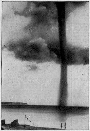
Waterspout off Rugen Island, Baltic Sea 1937

Waterspout off Rugen Island, Baltic Sea 1937

Waterspouts are (simplistically) tornadoes at sea, or on rivers and lakes. They have usually been regarded as curiosities of nature, because, unlike tornadoes, they do not often inconvenience the human race. Many waterspouts are feeble vortices which probably could not even come into existence in the turbulent air over the land, but they should not be taken lightly. Spouts have crossed onto land and become tornadoes, and some are tornadoes which have passed onto water. Even spouts far out in the ocean can be of tornadic size and power.

'Waterspout' is a rather inappropriate name, since spouts consist almost entirely of whirling cloud, with a plume of spray (the cascade) at the surface whipped up by the vortex as it touches the water. They do illustrate the difficulty of studying natural phenomena in the days before video and photography. Spouts could not be predicted, captured, or studied at leisure. Any student of waterspouts would have to rely on the accounts of people who had seen one, and they were not seen very often. They didn't even leave any physical traces unless they came ashore, which was an even rarer event. This is why the idea that spouts were literally waterspouts, streams of water pouring from the clouds (and raising spray when they hit the sea) lasted so long. An 18th Century scientist, defending the stream-of-water theory, even said, "the wonderful catalogue of nature needed not whirlwind-waterspouts to increase the number."

Waterspouts are whirlwinds, of course (something the Roman poet Lucretius knew), but it seems that powerful spouts can carry large amounts of water in the lower parts of their vortex. Some even lift water into their parent cloud, as shown by falls of salt rain after the spout has dissipated. Waterspouts are usually held responsible for the mysterious falls of fish and other aquatic animals. There are difficulties with this theory, but nobody has yet come up with a better one.

The chronology of remarkable waterspouts below is not inclusive. Many unusual spouts have had to be left out due to lack of space.

MARITIME NOTES:

Riverdance ferry will not be cut up - salvors


Riverdance


REFLOATING
the stricken Blackpool ferry will be later rather than sooner. The Riverdance does not look set to move until towards the end of the two weeks salvors described as "a window of opportunity".

Weather has played a part in hampering efforts to right the 6,000-ton vessel, which has been stuck on the beach near Anchorsholme Park since the start of February.

View our Shipwreck online special

See The Riverdance webcam

See our Riverdance picture gallery - updated daily

Salvage crews said there was a chance to move the ship sometime between now and March 13, but they say this is most likely to happen towards the end of this period.


Coastguard bosses insist the plan is still to right and then refloat the Riverdance – denying rumours that the move would be impossible and salvors would have to cut it up.

Oil Tanker Towed to Dock After SOS Call

YANBU, 6 March 2008 — An oil tanker carrying one million barrels of crude sent out a distress signal and was towed back to the King Fahd Industrial Port in Yanbu.

The ship, which reported engine failure about 200 kilometers from the port, arrived back at the port yesterday, officials told Arab News.

“KFIP’s emergency operation’s team rescued the oil tanker meandering amid the coral reefs following engine failure off the Duba coast,” Hammoud Al-Saadi, director general of the port, told Arab News yesterday.

Venture Navigation Co., Ltd. of Greece owns the 20-year-old Dominican-registered ship, according to Lloyd’s Registry. The ship was destined for the port of Aqaba, Jordan.

The distress call said the ship’s engines had broken down and was floating with the currents about 200 kilometers from Yanbu.

The rescue team found the captain of the ship steering without power as the weather was turning nasty. No injuries were reported.

“The successful operation averted a shipwreck and a major environmental disaster. The tanker was floating at an area close to virgin coral reefs. Any leakage of the ship’s load would have devastated the reefs,” Al-Saadi said.

Desalination plants in nearby Duba would have been affected by an oil spill, the port official added.

“Three powerful towboats struggled for 48 hours to bring the loaded tanker safely to the dock in Yanbu,” he said.

Oil from the Eastern Province is piped across the Kingdom for export from this northwestern port city. The western coast of Saudi Arabia is a maze of coral heads that can potentially damage and sink sea vessels. An accident involving a full oil tanker colliding with these underwater columns has a potential to cause a major environmental disaster.


RS

Tuesday, February 26, 2008

New Radar Technology Can Increase Tornado Warning Lead Times

Navy's phased array radar being adapted for weather use

A National Weather Radar Testbed has been established at the National Oceanic and Atmospheric Administration's National Severe Storms Laboratory to provide the meteorological research community with the first surveillance phased array radar facility available on a full-time basis.

Norman is already known as a national center for weather radar research and development. NSSL's research in Doppler radar led to one of the most successful and significant technology advancements since the launching of the first weather satellite.

Nearly 30 years ago, NSSL was a major participant in the development of Doppler technology that became the heart of the WSR-88D radar, or NEXRAD.

The deployment of a system of 120 NEXRAD radars across the United States was the cornerstone of the modernization of the National Weather Service.

Installation of the SPY-1A antenna and radome on the NWRT

Navy supply ship showing SPY-1 radar that is currently used to support tactical operations.

Phased array radar is currently used on Navy ships to support tactical operations.

Phased array radar technology may help forecasters of the future provide earlier warnings for tornadoes and other types of severe and hazardous weather. Researchers are adapting the SPY-1 radar technology, developed by Lockheed Martin to support tactical operations aboard Navy ships, to weather detection. The phased array radar project has begun a new stage in NSSL's leadership in the research and development of future generations of weather radar.

Research Partnerships

A unique federal, private, state and academic partnership is developing the phased array radar technology. Participants include NOAA's National Severe Storms Laboratory and National Weather Service Radar Operations Center, Lockheed Martin, U.S. Navy, University of Oklahoma's School of Meteorology and School of Electrical and Computer Engineering, Oklahoma State Regents for Higher Education, the Federal Aviation Administration, and Basic Commerce and Industries. The project - from research and development to technology transfer and deployment throughout the U.S. - is expected to take 10 to 15 years at an initial cost of approximately $25 million for the facility in Norman.

Promising New Radar Technology

Early tests of the phased array radar system show that the technology has the potential to vastly improve upon the capabilities of the national NEXRAD radar network for all weather radar applications. Using multiple beams and frequencies, phased array radar reduces the scan time of weather from five or six minutes for NEXRAD radar to less than one minute, producing fast updates of weather data.

The National Weather Radar Testbed allows NSSL and other meteorologists to determine if phased array radar will become the next significant technology advancement to improve our nation's weather services.

Schematic shows how the radar might scan storms as well as clear air, and also track aircraft and uncooperating targets.

The rapid scanning ability of phased array radar gives it the potential to be a multi-use, adaptively scanning radar.

Improved Warning Lead Time

In addition to faster updates, the new system can scan the atmosphere with more detail at lower elevations than current radar allows. It can also re-scan areas of severe weather very quickly, potentially increasing forecasters' warning lead times as storms rapidly transition to severe modes.

PAYOFF: This technology has the potential to increase the average lead time for tornado warnings well beyond the current average of 11 minutes. Other technology being developed at NSSL will extend lead times even farther.

Improved Understanding and Forecasts

The new technology will gather storm information not currently available, such as rapid changes in wind fields, to provide more thorough understanding of storm evolution. Researchers and forecasters can then improve conceptual storm models and use that knowledge to evaluate and improve stormscale computer models. The data will also be used to initialize computer models and improve forecasts.

PAYOFF: Phased array technology will increase fundamental understanding of storm evolution, in turn leading to improved computer models, more accurate forecasts and earlier warnings.

Reflectivity display from first tornado captured by the NWRTVelocity display from the first tornadic storm captured by the NWRT
Reflectivity and velocity displays of the first tornadic storm captured with the NWRT

NSSL RADAR RESEARCH

WSR-88D Improvements
  • Implementing range and velocity ambiguity mitigation techniques in the WSR-88D radar network will result in an improved ability for the WSR-88D to detect severe weather, flash floods, winter storms, and provide aviation forecasts.
  • An increased ability to identify aviation weather hazards and to track, classify and identify aircraft will improve airline safety and help fill gaps in homeland security.
Phased Array Radar
  • Phased array technology could significantly extend warning lead times, increase accuracy, and reduce the uncertainty of predicting severe weather events.
  • Adapting phased array technology to both weather observation and aircraft surveillance will provide significant cost benefits and a higher level of security to the nation
Real-time Applications
  • Researching and prototyping new severe weather warning applications using WDSS-II multi-sensor technology will help fast-track improvements into operations and provide a robust decision support system for forecasters.
Testbeds
  • The National Weather Radar Testbed at NSSL will shorten the cycle time from weather radar research to National Weather Service operations, leading to increased accuracy and lead-times, and reducing the uncertainty of predicting severe weather events.
  • A cost-effective network of many small radars that can scan lower regions of the atmosphere will provide better weather coverage in high population or weather-sensitive areas.
Mobile Doppler Radars NSSL PODCAST - Radar Research

National Severe Storms Laboratory Chief of Radar Research and Development Doug Forsyth discusses aspects of radar research and what’s in store for the next generation of weather radar. Recorded 8 November 2007

  • Section 1 - Types of radar research done at NSSL (5:43)
  • Section 2 - Transition of research to operations for new radar applications (3:11)
  • Section 3 - Doppler radar and new radar technologies being researched and how they compare (8:39)
  • Section 4 - Advantages of collaborative radar research (3:24)
  • Section 5 - Doug discusses his career and his advice for people considering a career in the atmospheric sciences (6:09)

headphonesLISTEN TO THE COMPLETE PODCAST RUNTIME 27:08 TEXT TRANSCRIPT


BE READY CAMPAIGN

Tennessee Severe Weather Awareness Week: Feb. 24-29

The National Weather Service, the Tennessee Emergency Management Agency and other supporting organizations are working together to help in providing the public with information about severe weather safety. Advance planning and increased awareness will help Tennesseans survive these deadly storms. Governor Phil Bredesen has proclaimed February 24-29, 2008, as "Severe Weather Awareness Week" in Tennessee.As we move into our Spring, now is the time to prepare ourselves for the hazards and dangers associated with severe weather. Severe weather can and does occur any time of the day and anytime during the year. Are you prepared?

Click on the link to download the booklet. Severe Weather Awareness Week Booklet 2008

MS Severe Weather Awareness Week
Sunday, Feb 24, 2008 - 10:30 PM
By AnneMarie Crumby
Governor Haley Barbour declares this week Severe Weather Awareness Week in Mississippi. The National Weather Service will issue a statewide test tornado warning on NOAA Weather Radios Wednesday morning.Schools, government agencies and businesses throughout the state are encouraged to participate in a tornado drill. Everyone is asked to buy a NOAA Weather Radio. It sounds an alarm when local severe weather watches and warnings are issued. These radios range in price from $30 to $70.

Emergency Management Looking for Severe Weather Spotters

Towson, Md. (February 7, 2008) – Local weather buffs have an opportunity to put their interest in meteorology to valuable practical use.

The Baltimore County Office of Homeland Security and Emergency Management is recruiting volunteers to help spot severe weather. The volunteers would be part of SKYWARN, a national network of amateur severe weather spotters, trained by the National Weather Service to spot severe thunderstorms, tornadoes, hail and flooding, snowfall and ice accumulation.

Along with the National Weather Service, the Office of Emergency Management will sponsor a SKYWARN and Spotter Class on Tuesday, March 11, 2008, 7 to 10 p.m., at the Baltimore County Public Safety Building, 700 E. Joppa Rd., Towson. The class will be held in the 6th floor conference room.

The class is free of charge

To register, email tbrush@baltimorecountymd.gov, or call the Office of Homeland Security and Emergency Management at 410-887-5996.

INTERNATIONAL WEATHER
By Arthur Rabjohn CEM

ENGLAND: Council flood funding payments exceed £15million Floods Recovery Minister John Healey today announced over £2.5million funding for six authorities across the country, to help them get back on their feet following last summer's floods. This means that over £15million has now been paid out under the Bellwin scheme, which covers costs incurred by local authorities during immediate action to safeguard residents and property or prevent suffering as a result of a disaster or emergency. This money is on top of up to £63million of other Government support made available to help flood-hit communities. FULL ITEM AT: http://www.communities.gov.uk/news/corporate/703254?version=1

USA: Night of Texas Wild Fires followed by fog chaos. Closure of Houston Hobby Airport led to major disruption as a result of dense fog. Planes were diverted to other airports, mainly DFW, and passengers sat on the tarmac for over two hours in some cases. Following a night of wildfires was there a connection?

NAMIBIA: Emergency Management Gets Blasting Omusati Governor Sackey Kayone has criticised the Regional Emergency Management Unit (REMU) for lack of means to respond to emergency situations. In a speech delivered on his behalf by Outapi Councillor Simon Shileka, he expressed reservations with the way finance is centralized at the expense of regional emergency units. MORE AT: http://allafrica.com/stories/200802251264.html

INDONESIA: A powerful earthquake hit off the coast of Indonesia's Sumatra island. The quake was centered about 160km south-southwest of Padang and had a magnitude of 7.3, and occurred at about 10km beneath the seabed. There are no reports of casualties or damage. A local tsunami watch has been issued and lifted after.

CHINA: China has forecast heavy snow and blizzards across its industrial and agricultural heartland over the next three days. At least 129 people have died. Transport is in chaos and cut off power and water appeared. Severe weather damaged millions of hectares of crops and killed more than 70 million animals. Snow and sleet would hit six provinces spanning China's central, eastern and northern regions. Blizzards were also expected in the northwestern part of central Hubei province, already plagued by winter storms earlier this month.

MADAGASCAR: Nearly 145,000 people have been left homeless by a cyclone that tore through Madagascar, killing 44 people. Cyclone Ivan struck the island's east coast last Sunday, and was followed by torrential rains which caused flooding. Winds gusting at more than 230km/h caused widespread damage. Infectious diseases such as diarrhoea are reported to be on the rise. The cyclone season is not expected to end until April, so the government has warned that further storms could follow.

ECUADOR: Persistent rains and floods have left Ecuador in a state of disaster as concern aver food shortages grows. Rains and swollen rivers have caused flooding in 13 of the country's 24 provinces, destroying homes, crops and infrastructure. At least 300,000 people have been affected, including 20,000 evacuated. 110,000 hectares of crops, including rice, coffee, corn, banana, cacao and sugar cane have been destroyed. A national emergency has been declared. EU MIC is monitoring the situation.

MARITIME NOTES:

Lack of talent blamed for shipping accidents
By Nadim Kawach on Sunday, February 24 , 2008


Shipping accidents have increased sharply worldwide over the past few years because of the introduction of complex systems and a lack of experienced crew abroad vessels, according to a specialised organisation.

The surge in accidents has boosted business at shipping yards and consequently pushed up the cost of vessel repair and maintenance, the Singapore-based DNV company said in a report sent to Emirates Business.


“Updated figures for 2007 show that the losses from navigational accidents within the shipping industry are continuing to increase. This trend was also confirmed by the insurance industry. Premiums may increase by as much as 30 per cent in 2008,” DNV said in the report, presented at a shipping conference yesterday.


“DNV monitors the frequency of serious accidents. Over the past five years, there has been an increasing incidence of serious navigational accidents in several shipping segments. This increase is confirmed by many insurance companies such as Skuld, Norwegian Hull Club and The Swedish Club,” said DNV, which covers a wide range of services including classification, certification, consulting, training, asset operations, verification, laboratory testing and technology qualification.


In addition to the increasing frequency of navigational accidents, the cost of each repair caused is rising.


The yards are overbooked, making it hard to find a repair slot, resulting in increased prices for firms. Collisions, groundings and contacts now account for 60 per cent of the most expensive accidents.


The report quoted Torkel Soma, principal safety consultant at DNV Maritime, as saying: “DNV’s statistics show a ship is twice as likely to be involved in a serious grounding, collision or contact accident today compared to only five years ago. In addition, estimates show the cost of these accidents has doubled. Since this is the general trend for the international commercial fleet, the maritime industry needs to act on this immediately.”


According to the report, the boom in the shipping market and increased deliveries of new ships have resulted in pressure on crews.


It says the shortage of officers has resulted in lower retention and faster promotion, adding that as a result, the general level of experience is decreasing on board. At the same time new technical solutions have also been introduced, which might have increased the complexity of operations.


“Reliable technology and complying manuals are no assurance against making errors. Collisions, groundings and contact accidents do almost always involve human acts,” Soma says.


Helge Kjeøy, regional manager DNV Maritime South East Asia, said: “The main factor explaining the negative developments over the past few years is the undersupply of crew worldwide. This results in reduced experience and the high commercial pressure results in high workload. Adding new and more complex equipment does not only help the situation. Avoiding accidents under such situations requires a good safety culture, something which the maritime industry evidently needs to focus more on.”


The experience of leading shipping companies shows the focus has to be turned more in the direction of human elements and organisational factors, including all those involved – from the directors of the company to the officers on the bridge.


Soma adds: “Safety improvements with reduced accident frequency have been achieved through a structured approach addressing behaviour and culture. For the industry to maintain its traditionally good track record, the resilience of operations has to be addressed on a larger scale.”


THE DNV REPORT

Singapore: Updated figures for 2007 show that the losses from navigational accident within the shipping industry are continuing to increase.


RS