Showing posts with label hurricanes. Show all posts

Tuesday, February 11, 2014

Experimental Storm-Surge Maps to Accompany NOAA Hurricane Projections

Emergency management crews will have another tool to help them protect low-lying areas from flooding the next time a hurricane approaches.

Beginning this year, the National Hurricane Center's projections will include surge maps that show where flooding is expected along the Gulf and Atlantic coasts.

Flooding that usually accompanies a hurricane is caused by a storm surge -- a rise in ocean water caused by the atmospheric pressure and wind that pushes water landward. Storm surges can kill, with nine out of every 10 deaths from hurricanes caused by the surge or its flooding, according to Federal Emergency Management Agency statistics.

The surge maps, which will be experimental for at least two years, will be issued at the first sign of a hurricane or tropical storm watch and will be continuously updated with each new hurricane forecast, typically issued every six hours, according to a release from hurricane center's parent agency, the National Oceanic and Atmospheric Administration.

Read > The rest of the story...

Thursday, December 4, 2008

Missing radioactivity in ice cores bodes ill for part of Asia

Missing radioactivity in ice cores bodes ill for part of Asia

When Ohio State glaciologists failed to find the expected radioactive signals in the latest core they drilled from a Himalayan ice field, they knew it meant trouble for their research.

But those missing markers of radiation, remnants from atomic bomb tests a half-century ago, foretell much greater threat to the half-billion or more people living downstream of that vast mountain range.

It may mean that future water supplies could fall far short of what's needed to keep that population alive.

In a paper just published in Geophysical Research Letters, researchers from the Byrd Polar Research Center explain that levels of tritium, beta radioactivity emitters like strontium and cesium, and an isotope of chlorine are absent in all three cores taken from the Naimona'nyi glacier 19,849 feet (6,050 meters) high on the southern margin of the Tibetan Plateau.

"We've drilled 13 cores over the years from these high-mountain regions and found these signals in all but one - this one," explained Lonnie Thompson, University Distinguished Professor of Earth Sciences at Ohio State.

The absence of radioactive signals in the top portion of these cores is a critical problem for determining the age of the ice in the cores. The signals, remnants of the 1962-63 Soviet Arctic nuclear blasts and the 1952-58 nuclear tests in the South Pacific, provide well-dated benchmarks to calibrate the core time scales.

"We rely on these time markers to date the upper part of the ice cores and without them, extracting the climate history they preserve becomes more challenging," Thompson said.

"We drilled three cores through the ice to bedrock at Naimona'nyi in 2006," said Natalie Kehrwald, a doctoral student at Ohio State and lead author on the paper. "When we analyzed the top 50 feet (15 meters) of each core, we found that the beta radioactivity signal was barely above normal background levels."

Tritium, an isotope of hydrogen, and chlorine-36 were also both absent from the Naimona'nyi cores, she said. They were able, however, to find a small amount of a lead isotope, lead-210, which allowed them to date the top of the core.

"We were able to get a date of approximately 1944 A.D.," Kehrwald said, "and that, coupled with the other missing signals, means that no new ice has accumulated on the surface of the glacier since 1944," nearly a decade before the atomic tests.

While the loss of the radioactive horizons to calibrate the cores poses a challenge for Thompson's research, he worries more about the possibility that other high-altitude glaciers in the region, like Naimona'nyi, are no longer accumulating ice and the impact that could have on water resources for the people living in these regions.

"When you think about the millions of people over there who depend on the water locked in that ice, if they don't have it available in the future, that will be a serious problem," he said.

Seasonal runoff from glaciers like Naimona'nyi feeds the Indus, the Ganges and the Brahmaputra rivers in that part of the Asian subcontinent. In some places, for some months each year, those rivers are severely depleted now, the researchers said. The absence of new ice accumulating on the glaciers will only worsen that problem.

"The current models that predict river flow in the region have taken recent glacial 'retreat' into account," said Kehrwald, "but they haven't considered that some of these glaciers are actually thinning until now.

"If the thinning isn't included, then whatever strategies people adopt in their efforts to adapt to reductions in river flow simply won't work."

Thompson fears that what's happening to the Naimona'nyi glacier may be happening to many other high-altitude glaciers around the world. "I think that this has tremendous implications for future water supplies in the Andes, as well as the Himalayas, and for people living in those regions."

The absence of the radioactive signals in the 2006 Naimona'nyi core also suggests that Thompson and his colleagues have been lucky with their previous expeditions to other ice fields.

"We have to wonder -- if we were to go back to previous drill sites, some drilled in the 1980s, and retrieved new cores -- would these radioactive signals be present today?" he asked.

"My guess is that they would be missing." The researchers' recent work has shown similar thinning on glaciers in Africa, South America and in Asia in the past few years.

WEATHER NOTE

Maritimes didn't escape hurricanes this year

The Maritime provinces were hit with the remnants from various tropical storms and hurricanes this year, even though there was a less than normal number of named storms moving up the Atlantic Coast in 2008.

In some cases, the effect was no more than light rain, but in others, it was heavy rainfall fanned by gale-force winds.

It was the remnants from hurricanes Hanna and Kyle, both of which occurred in September, that brought the most severe weather conditions for New Brunswick, said Alex Sosnowski of State College. Pa., a spokesman for the AccuWeather.com Hurricane Centre.

Sosnowski said not all of the tropical storms moved into the province from the Atlantic Coast. He said some of them made their way inland, were re-energized by the Great Lakes and then, proceeded to head eastward, entering New Brunswick from the west.

The hurricane season officially runs from June 1 to the end of November, although you can sometimes get them later, such as occurred in 2005.

To be designated a name, a disturbance has to make it at least to tropical storm status. A tropical storm represents the level of severity immediately below that of a hurricane.

Sosnowski said hurricanes are rated in terms of intensity from Category 1 to Category 5 on the five-step Saffir-Simpson scale. Any of them ranking between Category 3 and 5 are considered to be major hurricanes with tremendous destructive capacity, he said.

Last year, he said there were 15 named storms, six of which reached hurricane status.

In the spring of this year, Sosnowski said the team of hurricane experts at Colorado State University predicted that there would also be 15 named storms this year, but that eight of them would graduate to hurricane status.

And they appear to have hit the nail just about on the head, said the AccuWeather.com meteorologist. To this point, he said there have been 16 named storms, eight of which became hurricanes.

Sosnowski said the last tropical storm this year was Paloma, which was a Category 4 hurricane. He said it strengthened rapidly and slammed into Cuba a few weeks ago, causing significant damage in much of that country.

The strength of high pressure over the Atlantic this year "pushed everything to the left," he said. As a result, he added, a lot of named storms ended up swinging into the Gulf of Mexico or south toward Central America.

Sosnowski anticipated there was little chance of another tropical storm developing the rest of this year.

This time of the year, he explained, there are significant wind shears that rip the tops off tropical disturbances before they can get a chance to develop into a storm or hurricane.

MARITIME NOTE

Rogue Waves: They're Real, & They're Spectacular

I recently learned I might serve this spring as a subject expert aboard a cruise ship crossing the Atlantic, as part of an "enrichment program" that provides passengers the opportunity to interact with experts in various fields. I've been identified as an individual who will address "Everything You Wanted to Know about the Weather, Sea and Sky - and Then Some!"

Sounds great. My only real concern was whether I might get sea sick, having never been on an ocean cruise. But then I began thinking about a recent presentation (ppt) on "rouge waves" given by Linwood Vincent, of the U.S. Office of Naval Research, at a meeting of the DC Chapter of the American Meteorological Society. As I thought about Vincent's nightmarish stories and pictures, I worried that sea sickness could be the least of my problems, even if the odds of encountering a rogue wave are extremely small.

Keep reading for more on these monstrous waves...

Technically, rogue waves, sometimes referred to as "freak waves," are defined as waves whose height from wave crest (highest point) to wave trough (lowest point) is more than twice the average height of the largest one-third of waves in a set of measured waves. More simply, as Vincent explained, they are essentially "big waves relative to what you expect to be there."

As described nicely by an article in the New York Times, the two most likely explanations for the occurrence of rogue waves are when smaller waves merge to form large waves, and when storm-generated waves crash into ocean currents coming from the opposite direction.

Vincent cites the example of an oil platform in the North Sea that was experiencing rough but reasonable waves of 13 to 26 feet during a storm on New Year's Day, 1995. Suddenly, seemingly out of nowhere, the platform was hit and extensively damaged by a monstrous wave that instruments measured at more than 80 feet in height (the so-called "Draupner Wave").

Want to go even bigger? In February 2000, scientific instruments onboard a British research west of Scotland measured waves up to 95 feet. More recent (but perhaps somewhat less reliable) observations have recorded wave heights up to 110 feet, about the same height as the Statue of Liberty. Just as important as height is that rogue waves are usually extremely steep. Plowing into one is like hitting a nearly vertical wall of water. If a vessel is lucky enough to survive the initial impact, then coming over the crest is like riding down the steepest incline of the world's tallest roller coaster.

And, by the way, I've never been so scared as my first ride on a roller coaster not too many years ago -- and have not been on one since.

For centuries, these enormous waves had been dismissed as myths. But scientists now recognize these giant wallops of water are far more common and destructive than once imagined. According to Vincent, freak waves are suspected of sinking at least dozens of large ships, including supertankers, while taking hundreds of lives. Freak waves are known to occur in the Great Lakes as well as the oceans. It is believed that just such a wave contributed to the sinking of the freighter SS Edmund_Fitzgerald in May 1975 on Lake Superior. All 29 hands perished in this most famous of Great Lakes disasters.

Cruise liners, at least in recent times, have been more lucky -- if you can call it that -- in their close encounters with rogue waves. In February 1995, the Queen Elizabeth II was slammed by a 95-foot-high wave in the North Atlantic. Captain Ronald Warwick described it as "a great wall of water... it looked as if we were going into the White Cliffs of Dover." But the ship survived with some passengers suffering relatively minor injuries. In April 2005 off the coast of Georgia, the Norwegian Dawn, a 965-foot ocean liner, was struck by a rogue wave estimated at 70 feet high. The wave smashed windows, sent furniture flying, injured four passengers and, not surprisingly, instilled widespread fear and panic.

And the accounts above are only a sampling of the many that have been reported. For example, see: here and here.

The only video of an actual encounter with a rogue wave I'm aware of is the amazing encounter of a 100-foot fishing boat, which was shot for the Discovery Channel's program, "The Deadliest Catch."

As for that gig on the cruise ship, I'll take the advice of my 4-year-old granddaughter: "Don't be scared, Pop-Pop. I didn't get scared when we went sledding last year down the big hill." How could I not go after that kind pep talk? And besides, running into a rogue wave is even less likely than being swept up by a tornado or hit by lightning. But I'll be sure to pack the sea-sickness pills, and probably not mention rogue waves to the passengers.

French join Canadians in Atlantic search of French crew

HALIFAX - A French naval reserve vessel has joined Canadian crews searching for survivors of a French-owned vessel that capsized and sank near the south coast of Newfoundland on Tuesday.

There were four people on board the 30-metre Cap Blanc when it went down about 16 kilometres south of Marystown, N.L. on the Burin Peninsula.

But officials said Wednesday the chance of finding survivors was growing slim. It's not known whether the crew were wearing survival suits.

Meanwhile, another rescue centre spokeswoman denied a French media report that Canadian divers had heard noises inside the vessel before it sank in about 100 metres of water at 2 p.m. local time.

Jeri Grychowski said there was no truth to the report.

The vessel was reported overdue Tuesday after departing Argentia, N.L. for the 12-hour voyage to its home port on the French islands of St-Pierre-Miquelon, off Newfoundland's south coast.

Searchers have found an empty life-raft and a life preserver, but no sign of survivors or other wreckage on the surface. The Cap Blanc was known to have carried two life-rafts.

On Wednesday, a Cormorant helicopter from Gander, N.L. continued the search, along with two coast guard vessels and the French naval ship, Fulmar.

St-Pierre is 20 kilometres off the southern tip of the Burin Peninsula, and the drama unfolding nearby is riveting many on the island of 6,500.

Finding the boat overturned in the water delivered a strong blow to the community, wrote St-Pierre magazine Mathurin on its website.

"There is an immense sadness, of a kind felt by ocean communities struck to the heart by an implacable sea," wrote author Henri Lafitte. "The wait continues until the limits of hope."


RS

Friday, November 14, 2008

5 Most Dangerous U.S. Earthquake Hot Spots Beyond California

5 Most Dangerous U.S. Earthquake Hot Spots Beyond California

California isn't the only state with a serious earthquake hazard. There are several lesser-known fault zones lurking in other parts of the country that are just as dangerous, if not more dangerous, than the famed San Andreas Fault.

Some of these faults are capable of producing quakes bigger than the 1906 San Francisco quake, but because the time between major jolts is longer than in California, many people who live near these faults don't even know they are there.

Here's a closer look at five of the country's most hazardous seismic hot spots outside of California.

Map: USGS

Cascadia_tsunami10houronlylg

A computer simulation of the 1700 Cascadia earthquake tsunami after 10 hours / USGS.

THE PACIFIC NORTHWEST:

The biggest earthquakes in the country are not in California. A much greater hazard, at least in terms of sheer magnitude, exists to the north of the San Andreas Fault where the ocean crust is being forced beneath the North American continent.

Known as the Cascadia Subduction Zone, this 680-mile long stretch of colliding land mass 50 miles offshore of Oregon, Washington state and southern British Columbia is capable of generating magnitude 9 earthquakes 30 times more powerful than the worst the San Andreas can dish out.

"There are lots of other earthquakes that may happen first, but they won't be as big," said marine geologist Chris Goldfinger of Oregon State University in Corvallis.

An earthquake of this size would completely devastate the region, which includes Portland, Seattle and Vancouver. There could be thousands of deaths and unprecedented damage for a quake in this country. Major travel routes will be impassable. The shaking could last a full four minutes, which would damage or bring down structures that could have survived a shorter duration.

On top of the danger from shaking, within minutes, a tsunami would likely inundate the low-lying coastal areas. Cascadia is the same type of fault that caused the 2004 Sumatra quake and tsunami.

Fortunately, these mega quakes only come around once every few hundred years. Unfortunately, the fault may be due for another big one any day now.

The last monster quake that ruptured the entire length of the Cascadia fault occurred in 1700 and was around a magnitude 9. It created a tsunami that crossed the entire Pacific Ocean and caused damage along parts of the Japanese coast.

Scientists had calculated an average time between these major quakes of around 530 years. But Goldfinger's recent research on marine landslides caused by earthquakes over the last 12,000 years has revealed many magnitude 8 earthquakes on the southern portion of the fault in the intervening years, bringing the average down to 270 years.

"It's been 308 since the last one so the probability is much higher," Goldfinger said. In fact, is new research on landslides puts the probability of a magnitude 8 or greater quake as high as 75 percent in the next 50 years.

Making matters worse, the region isn't prepared.

"Portland has lots of unreinforced masonry buildings" that are likely to collapse in a major quake, Goldfinger said. "The retrofitting has barely begun."

"It's going to be a mess."

Newmadrid_tree NEW MADRID:

Most of the major earthquakes in the world occur at tectonic plate boundaries where land masses are colliding or pushing past one another. But in the middle of the country lurks a geological enigma near New Madrid, Missouri, that has produced some of the largest quakes on record for the United States but has yet to be fully explained by scientists.

"It's a big mystery," said geologist Eugene Schweig of the U.S. Geological Survey, who has studied the area for 23 years. "New Madrid is about as far from a plate boundary as you can get."

In 1811 and 1812, a swarm of at least three massive earthquakes struck near New Madrid, the largest of which exceeded a magnitude 8 and caused violent, damaging shaking in an area 10 times larger than did the 1906 earthquake. The quake was felt over an area of two million square miles — nearly two-thirds of the country.

During the quakes, the ground rose and fell, trees were bent, deep cracks opened up in the ground, large landslides swept down hills, huge waves washed boats out of the Mississippi River and river banks, islands and sand bars gave way.

Damage was widespread, but only a few people died thanks to the sparse population in what was then the Louisiana Territory but today is near the junction of Missouri, Illinois, Kentucky, Tennessee and Arkansas. Were another magnitude 8 earthquake to strike the region today, the toll would be much, much higher.

By analyzing deposits of sand that squirted out of the ground during past major quakes, Schweig and others estimate an average time between earthquakes of 500 years. But earthquakes are impossible to predict, and because scientists aren't even sure why major quakes occur away from plate boundaries, it is even more difficult to estimate a probability for New Madrid.

The USGS's best estimate is that there is a seven to 10 percent chance of a major earthquake between magnitude 7.5 and 8 in the next 50 years. While the probability of a major quake on any given day in the New Madrid region is far less than that of the Bay Area in California, the potential for disaster if a quake does strike is greater due to the size of the area that could be violently shaken.

Another factor is the lack of awareness and preparedness in the area. It is nearly impossible to live in the San Francisco or Los Angeles areas without knowing there is an earthquake hazard. Small quakes remind residents of that every few months or weeks. But 1812 was a long time ago, so earthquakes aren't anywhere near the top of most people's concerns in New Madrid. And most buildings in the area haven't been retrofitted.

"We have buildings that have been sitting around for 200 years," Schweig said. "It's just bricks sitting on top of bricks. There are schools and police stations built like that."

Image: 1904 photo of trees bent during the 1811/1812 New Madrid earthquakes / USGS

SALT LAKE CITY:

The forces that have built Utah's incredibly scenic landscape are also the source of a very serious and potentially deadly seismic hazard. Running along the base of the western edge of the Rocky Mountains, the 240-mile Wasatch Fault lies underneath Salt Lake City and the state's urban corridor, home to 1.6 million people.

Though the Wasatch Fault has not delivered a major quake since the Mormon settlers arrived in 1847, geologists have found evidence that it is capable of unleashing jolts as big as magnitude 7.5. It is one of the world's longest "normal" faults, where the land on one side of the fault drops down relative to the other side during an earthquake. During prehistoric times, the fault slipped as much as 10 feet during a single quake.

"That's basically the process that formed the Wasatch Range," said geologist Chris DuRoss of the Utah Geological Survey. Over the last 17 million years, the fault has experienced almost seven miles of slip, raising the mountains above the adjacent valley floor.

The fault has distinct segments that act independently, each with its own history of earthquakes. On average, every 300 to 350 years, one of the central segments, which underlie the most populated areas including Salt Lake City and Provo, has had a major earthquake. The last big one was 300 years ago.

"We're basically due for an earthquake," said DuRoss, who has studied evidence of ancient quakes in trenches dug across the different segments of the fault. "We're really getting right into that zone when we'd expect to see one."

The prognosis gets even more grim with a closer look at the segment that underlies Salt Lake City and the segment just to the north. Both average a big quake every 1,300 years. The Salt Lake City segment last ruptured just about 1,300 years ago, and the last big quake to the north was around 2,100 years ago.

The danger from a major earthquake is heightened in the Salt Lake Valley because it sits atop an ancient lake bed made of softer sediments that tend to amplify seismic waves. This is bad news for an area that has around 185,000 vulnerable buildings made of unreinforced masonry that isn't built to survive an earthquake. Most of these are homes, but some are schools and other public buildings.

Video: Utah Geological Survey


Alaskaroaddamage

The Seward highway in Alaska after the 1964 earthquake / USGS

ALASKA:

The second-largest earthquake ever recorded struck Alaska's Prince William Sound in 1964. The magnitude 9.2 quake killed 128 people, most by the resulting tsunami.

In some places, the ground was uplifted almost 38 feet, and in others it dropped more than seven feet. The tsunami reached heights of around 220 feet locally, and killed 11 people 1,650 miles away in Crescent City, California.

The "mega-thrust" quake was the product of the collision of two tectonic plates, the oceanic plate being forced beneath the continental plate. Those plates are still moving and accumulating stress that will eventually be released in another big quake. The geologic record shows gaps of 350 to 900 years between monster quakes, which would seem to put the Alaskan coast in the clear.

But there could be several smaller magnitude 8 quakes filling those gaps that aren't quite big enough to show up in the geologic record, said geologist Peter Haeussler of the U.S. Geological Survey in Anchorage. "There's enough question that we just really don't know."

And Alaska has plenty of other sources of earthquakes to contend with. The oceanic plate bends and sinks as it is pushed beneath the continent, which can cause quakes potentially up to magnitude 7. And there are plenty of active faults on dry land as well.

"The big Kahuna for Alaska is the Denali Fault," Haeussler said, which had a 30-mile-long rupture in a magnitude 7.9 earthquake in 2004.

Alaska's biggest vulnerability is its transportation infrastructure. Virtually everything and everyone that goes anywhere in the state passes through Anchorage. The airport sits on ground that could suffer liquefaction — where sediments behave like a liquid when shaken in an earthquake — that could seriously damage runways and isolate the rest of the state.


Hawaiieqdamage HAWAII:

Hawaii is well known for its volcanic hazard, but the islands are also susceptible to major earthquakes such as a magnitude 7.9 quake in 1868 that killed 77 people. Evidence of prehistoric quakes is hard to come by in Hawaii, making it especially difficult to guess when the next big one will strike.

The Hawaiian Island chain was formed by a massive plume of extra-hot magma rising through the molten mantle between Earth's crust and core. The plume forced its way through the ocean crust, creating a volcano. As the Pacific plate slowly moved over the stationary plume, new volcanic islands were formed as older ones went dormant — the Big Island is where the magma is currently breaking through.

"All our earthquakes are ultimately associated with the processes that form the volcanoes," said earthquake seismologist Cecily Wolfe at the University of Hawaii at Manoa.

Loading the ocean crust with massive volcanoes — the from ocean floor to peak, the Big Island is the tallest feature on — causes it to flex, which can produce earthquakes. Even more dangerous are the quakes caused by the expansion of the volcano as new magma pushes out from below. These jolts can be very large and cause destructive tsunamis as well. More than half of the people killed by the 1868 died in the ensuing tsunami.

With only the historical earthquake record to go by, scientists have little data to help them estimate the probability of another big quake in the future. The most recent giant quake was a magnitude 7.2 in 1975, 107 years after the previous one. Does this mean Hawaii can relax for another 70 years or so? It's impossible to say. And since 1868, there have been seven quakes of magnitude 6.2 or greater, most recently a 6.7 in 2006 that caused $250 million in damage.

Hawaii is fortunate that most of its biggest earthquakes occur on the relatively sparsely populated Big Island. And the most active part of the Big Island is the south flank, which would send a tsunami out to sea instead of toward the other islands. But big ones that do sometimes strike the west flank of the island could send a tsunami to the much more populated shores of Maui and Oahu.

"I'm sure that many people are completely unaware of the local tsunami hazard on the other islands," Wolfe said.

In the past, some of the earthquakes caused by the flexing of the crust under the weight of the islands have struck near Maui, including a magnitude 6.8 in 1938. And Hawaii has plenty of older buildings that won't survive major shaking, particularly many homes that are not bolted down to a solid foundation.

"Those buildings can literally walk off their blocks during an earthquake," Wolfe said.

WEATHER NOTE


A study of data from the National Hurricane Center shows an increase in activity.
Thursday, October 23, 2008

An analysis of data from the National Hurricane Center shows the United States has entered a period that is producing the strongest tropical systems on record. Research shows that while the intensity of hurricanes is increasing, the storms' effects are also reaching further inland.

"If the future is like the past, we probably have another ten, 15 or 20 years left in this active period," says Colorado State University atmospheric science professor Bill Gray.

Gray says the increase in activity is the result of changes in currents in the Atlantic Ocean. He believes variations in the ocean's salinity are leading to more favorable conditions for tropical development.

"There's been too much said and too many people trying to jump in and say it's human-induced global warming," Gray adds.

Other scientists disagree. The Union of Concerned Scientists' Brenda Ekwurzel acknowledges that natural factors play a role, but she says human activity has increased the temperature of the oceans, and warmer oceans can produce more tropical systems.

"We're looking at lots and lots of tropical storms," Ekwurzel says. "When one does turn into a hurricane, it's more likely to be a very, very intense storm."

Numbers from the National Hurricane Center show 207 named storms in the Atlantic since 1995. That figure represents a 68 percent increase from the previous 13 years. The data also show a 75 percent increase in hurricanes over the same period.

MARITIME NOTE

All hands on deck in simulated oil spill exercise

Photo: Darrin Zammit Lupi.

Mariners looked on curiously as the police and armed forces yesterday showed off their speedboats while ships congregated some miles off Valletta to take part in an oil recovery response exercise.

The exercise, organised by the Malta Maritime Authority and European Maritime Safety Agency, simulated the detection of a heavy oil slick off Valletta, "reported" by a fishing boat to the authority's Vessel Traffic Services (VTS).

The first call was made to the Harbour Master at 5.30 a.m. and the response was initiated through VTS calls to everyone concerned. The authority's Control Centre was fully manned by 6 a.m.

Meanwhile, vessels arrived on the scene to deploy oil-retaining booms and skimming equipment to recover the slick.

Weather conditions were favourable as the MT Santa Maria swept and skimmed the oil off the surface, in coordination with vessels from the agency's pollution response network.

When an EU member calls for help, these vessels can be deployed to help in the clean-up and response operations.

Harbour Master Capt. Richard Gabriele explained that although the exercise is a simulated one, the conditions were very real.

"The response has to be timely and coordinated and everyone has to strictly abide by the instructions," he said.

Commenting on the outcome of the exercise, Capt. Gabriele said he was confident the situation would be tackled successfully in the event of a real spill.

These recovery exercises are held every year by the authority and relevant stakeholders to sharpen the island's capabilities to deal with various types of oil pollution.

From the blog: UP Ibalon Bicol

A Sorry Maritime Safety Record Indeed In The Philippines

Few question that currently Sulpicio Lines holds the most notoriety among local shipping companies. But as I have pointed out in a previous article ["The Blame Game and Other Musing", 7/13/08] the combined WG&A is not too far behind Sulpicio, going by actual statistics.

Maybe due to the sheer number of incidents, a few of these gets left out. Or we may not be too meticulous in keeping records (the Maritime Industry Authority [MARINA] doesn't even have its ship database in order). Or far-flung incidents sometimes does not catch the attention of them national media (except when casualties are simply too many).

Few would remember that in May 1980, the Sulpicio ship MV Dona Paulina struck bottom. The same thing happened to Don Victoriano I in April 1982. Both ships were declared total losses. These two incidents happened before the infamous Dona Paz and Dona Marilyn accidents in 1987 and 1988 (see Totie Mesia's article, "RP's Maritime Disasters: A Harvest of Shame and Blame", 11/08/08). Aside from these, Sulpicio Lines' ships were also involved in minor incidents like grounding, collision, ship fire and engine breakdowns that did not involve loss of life or the total loss of the ship.

Maybe to break its string of "bad luck" (the local euphemism for loser's fate), Sulpicio Lines changed the name of their ships into Princesses. For a while it probably broke Sulpicio's jinx but on December 1997, it lost MV Philippine Princess (a former flagship) to fire and subsequent sinking followed by the sinking of the MV Princess of the Orient (another former flagship) in September 1998. Finally, "bad luck" caught up with a reigning flagship, the MV Princess of the Stars, which capsized recently.

In the same period, some other obscure incidents happened to ships not connected to Sulpicio. In the early '90s the following ships were lost:

1. MV Emerald which capsized according to MARINA records.

2. MV Ruby I of Alexis Shipping: a RO-RO that sunk just off the port of Calapan due to a holed bottom.

3. A SuperCat (a catamaran) of Aboitiz was lost due to another holed bottom between Mindoro and Batangas.

4 . MV Manila City of William Lines: a Manila-Cebu ship that caught fire while under drydock in Cebu City and was totally lost.

From the mid-'90s and 2000, the following ships were lost to fire:

1. MV Viva Antipolo 7 which caught fire in 1995 according to MARINA records. This ship was totally lost.

2. MV Gretchen which caught fire in 1996 according to MARINA records.

3. MV Kalibo Star of Maypalad Shipping which caught fire in 1997.

4. MV SuperFerry 7 of WG&A: caught fire on March 1997 just after unloading passengers in North Harbor, Manila and was lost.

5. MV Rosalia II of Lapu-lapu Shipping: a Cebu-Cataingan ferry that caught fire a few kilometers before Cataingan port, on August 1999. Three passengers were killed.

6. MV SuperFerry 6 of WG&A: caught fire on October 2000 just off Batangas and was lost. Its nearness to major sea lanes and ports assured the survival of all the passengers.

In this decade, the following steel ferries of minor shipping lines met major accidents. The details of these incidents are not complete:

1. MV Penafrancia which caught fire according to MARINA records.

2. MV Ruperto Jr. of Tamula Shipping: a Camiguin ferry which caught fire.

3. A Super Shuttle Ferry ship of Asian Marine Transport capsized.

4. MV Joy-Ruby of Atienza Shipping: sunk just off the port of Coron, Palawan.

5. MV Pulauan Ferry of George&Peter Lines: a Siquijor ferry that sunk off Cebu City.

Additionally, the following major incidents happened in the last 6 years:

1. MV Princess Camille of Shipshape Shipping: took in water while unloading passengers in Odiongan, Romblon and capsized.

2. MB Mae-Ann 5 of Lobrigo Shipping: overwhelmed by waves off Masbate City on May 12, 2005 while Typhoon Caloy was blowing. 27 people died.

3. MV Princess of the World of Sulpicio Lines: caught fire off Zamboanga del Norte coast on July 2005 and was totally burned.

4. MV Dona Ramona of Basilan Shipping: a bomb exploded while docked in Lamitan, Basilan, on August 8, 2005. Three died.

5. MV Butuan Bay of Gothong Shipping: its engine exploded just after leaving Cebu City on May 16, 2007. Three crewmen died.

6. MV Blue Water Princess of Blue Water Princess Shipping: bad weather and strong waves caused it to capsized off Bondoc Peninsula, Quezon on July 12, 2007 where 12 persons died.

7. MV Northern Samar of Bicolandia Shipping capsized in the height of a typhoon while docked in Tabaco port. Big waves moved the ship against a rock and the bottom was holed.

Additionally, an explosion and a fire happened on August 2002 while MV Tacloban Princess of Sulpicio Lines was drydocked. Two people were killed.

These 22 major incidents are separate from those mentioned in Totie Mesia's article. Proving that marine safety is indeed poor in this country.


Storm Report


Messing About In Ships Podcast


Have a super weekend!

RS

Thursday, November 13, 2008

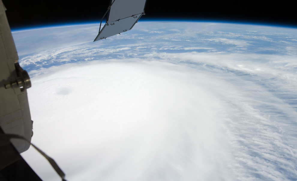
Hurricanes, as seen from orbit

Hurricanes, as seen from orbit

Hurricane Ike just rolled across Cuba, and soaked parts of Haiti - both regions still reeling from recent Hurricane Gustav. Ike appears to be weakening now, but is headed tward the Gulf Coast of the U.S., and may yet strengthen.

The crew aboard the International Space Station was able to take a photo of Ike from 220 miles overhead last Thursday - one in a long series of great NASA photographs of hurricanes from space. Here are some of the best, from the past several years. (25 photos total)


Additional photo's - just fantastic!


WEATHER NOTE

Hurricane Center Works with Google on Storm Surge Warning

Danger Zone
Americans may soon use Google to see whether their homes are threatened by a hurricane's storm surge, said the director of the National Hurricane Center (NHC) in March.

Storm surge, the massive wall of water carried inland by a hurricane, destroys homes in vulnerable coastal areas, and is a great threat to those who ignore evacuation orders.

NHC Director Bill Read said a planned program will pair a Google application with storm surge data that meteorologists have used for years. Together, the application and weather data will determine the flooding threat of any storm category.

"People can plug in their address and see at what level they are at risk," Read told the Reuters news service.
He said he hopes the program would be available in time for the Atlantic hurricane season, which begins June 1 and ends November 30.

Hurricane forecasters use a computerized model called SLOSH (Sea, Lake and Overland Surge from Hurricanes) that estimates storm surge heights by taking into account a hurricane's size, internal pressure, forward speed, track and wind strength.

The idea to make SLOSH models publicly available evolved from the phone calls that inundate local emergency managers and weather forecast offices every time a hurricane threatens: Read said people ask what flooding will be like at their homes.

"We're not going to know that off the top of our heads," he said. "So we can say, ‘Go to our Web site,' and it's there."

Hurricane forecasters will also offer a color-coded graphic this year on the NHC Web site, www.nhc.noaa.gov, that will indicate storm surge probabilities for threatened areas, similar to forecasts already available on wind speed probabilities. The graphic will indicate the probability of the surge reaching or exceeding 5 feet within a given number of hours, Read said.

It promises to help local emergency managers with key decisions, such as when to lock down bridges and what roads could be washed out or need to be cleared.

Students Still Iffy
Although text messaging systems have received much attention as a viable means of alerting students during a crisis, so far students have not embraced the idea, according to an Associated Press news report.

Hundreds of campuses have adopted text alerting (where students sign up for the alerts), but the enrollment rate among students and faculty is less than 40 percent, according to one provider of text alerting. According to another provider, enrollment was less than 30 percent.

Some students are concerned about giving out personal information, and others are indifferent, thinking a tragedy like last year's shootings at Virginia Tech will never happen to them. In fact, four in 10 students at Virginia Tech have still not signed up for text alerts, according to the report.

Experts said students will eventually gain confidence in text alerts, and they should be just one of many means of communicating with students and faculty.


Tower of Ash
In mid-March, a tower of ash rose hundreds of feet above the Kilauea volcano at Hawaii Volcanoes National Park, attracting residents and tourists who wanted to catch a glimpse of the first explosive eruption there in more than 80 years.

Because of a tenfold increase of sulfur dioxide emissions from the volcano, the state's health and civil defense officials were concerned about how the ash and gasses spewed from Kilauea may affect public health. Officials monitored the emissions and wind patterns just in case they moved toward the local population.

Another small explosion occurred on the morning of April 16, and civil defense officials advised nearby residents that sulfur dioxide levels "may be high enough to cause severe reactions [for] those in the sensitive groups, as well as those in the general population," the Honolulu Advertiser newspaper reported.

An evacuation center was set up at the Naalehu Community Center, but the county lifted the evacuation advisory when sulfur dioxide levels dropped.


Super Tuesday Tornadoes
What's being called the deadliest tornado outbreak in the United States in 20 years - which struck on Super Tuesday - took the lives of more than 50 people and injured hundreds.

Tornadoes and severe storms hammered the nation's midsection, sweeping through 18 counties in Tennessee, Kentucky, Mississippi and Arkansas on Feb. 5 and Feb. 6.

Tennessee was hit hardest, with 33 people dead, 189 injured and approximately 525 homes destroyed. Reports of winds up to 200 mph were reported, and damage to Union University in Jackson was estimated at $40 million.

The outbreak was the deadliest since May 31, 1985, when storms killed 76 people across Ohio and Pennsylvania.

MARITIME NOTE

Seafarer Honored for Risking Life in 24-Foot Waves to Save Drowning Man


John O. Dacuag (left) receives the Coast Guard’s Gold Lifesaving Medal from Rear Adm. Manson K. Brown.


Seafarers ([1] SIU) member John Dacuag put the extensive safety and rescue training he received from the union’s training center in Piney Point, Md., to good use in the middle of the Pacific Ocean and a typhoon when he jumped into the 24-foot seas to rescue a crewman from a sunken ship.

For his heroic efforts, Dacuag was awarded the Coast Guard’s Gold Lifesaving Medal, the Coast Guard’s highest civilian award, in a Honolulu ceremony late last month.

Dacuag was sailing aboard the U.S.-flagged cargo ship the Horizon Falcon in July 2007, when the ship received a distress call from another cargo vessel, the Hai Tong No. 7, which was about 375 miles northwest of Guam. The Horizon Falcon changed course and steamed toward the Hai Tong several hundred miles away.

But when the ship arrived the next day at the last known position of the Hai Tong, it found crew members in the water and oil slicks and debris from the sunken cargo ship. The wake of Typhoon Man-Yi was generating 24-foot seas and 40-mph winds.

On board the Horizon Falcon, Dacuag volunteered to try reaching a struggling Hai Tong crewman in the water. Climbing down a ladder on the Horizon’s portside, he attempted to reach the struggling man. According to the Coast Guard citation.

His lifesaving effort was particularly dangerous due to the severe weather, treacherous sea conditions and large amount of debris created by the passing typhoon and stricken vessel….Despite the grave risks to his own safety, Mr. Dacuag hung from the pilot’s ladder in 15–24 foot seas…he was submerged several times in water over his head.

Several times he was able to grab the man. But the winds, heavy seas and the ship’s movement broke his grasp several times. Then,

without consideration for his own life, Mr. Dacuag jumped into the extremely hazardous waters and swam to the survivor through 24-foot seas and attached the grappling hook and line to hoist the survivor on board.

Rescue efforts by the Horizon Falcon and Coast Guard search and rescue teams were able to save 13 of the 22 crew members.

At the awards ceremony, Rear Adm. Manson K. Brown said Dacuag’s

heroic daring demonstrates the absolute highest caliber of seamanship.

For more information on the SIU’s Paul Hall Center for Maritime Training and Education, where Dacuag took his rescue and training courses, click [2] here.

Marine Safety Investigation Report - Final

Man overboard fatality from the research survey ship
Geosounder, 25 August 2007
Man overboard fatality from the research survey ship Geosounder, 25 August 2007. ATSB Transport Safety Report 246 on the independent investigation into the man overboard fatality from the research survey ship Geosounder which occurred about 185 miles north-east of Cairns, Queensland on 25 August 2007.


RS

Tuesday, October 28, 2008

Hurricanes, high winds and heavy seas in the Gulf of Mexico

Hurricanes, high winds and heavy seas in the Gulf of Mexico

October 13, 2008 (Computerworld) When Lance Gibson talks about a storm knocking out his systems, he doesn't mean the infamous worm. He might be referring to the latest hurricane to sweep through the Gulf of Mexico or to the lightning accompanying a vicious thunderstorm.

Gibson is the offshore infrastructure communications supervisor for Chevron Corp.'s oil fields in the Gulf of Mexico, overseeing the IT needs of the company's offshore production facilities as well as its onshore support centers.

"Basically, I'm responsible for the entire infrastructure delivery," he says, "from the servers onshore all the way to the microwave, wireless and satellite communications we use for our voice and data communications offshore." We spoke with Gibson in mid-August; joining the conversation was Chevron public affairs representative Qiana Wilson.

A couple of weeks after our conversation, Hurricane Gustav provided a dramatic reminder of the kinds of situations Gibson has to deal with. Chevron and other companies with facilities in the Gulf evacuated their workers and shut down their oil platforms in advance of the threatening storm.

Once Gustav passed, Chevron began assessing its facilities and planning on remobilization of personnel, but Hurricane Ike put an end to that and forced another evacuation. At the time of this writing, Chevron reports that although several of its platforms were toppled by the storms, the company has once again started remobilizing its personnel.

Where are the offshore oil facilities that you support?

Gibson: We support the entire Gulf of Mexico region, from offshore Texas to offshore Alabama, whether our operations are on the OCS [Outer Continental Shelf] or in the deepwater areas of the Gulf of Mexico. That includes all of our offshore production platforms and drilling rigs, as well as our onshore operations that pertain to our Gulf of Mexico business units.

Gulf of Mexico

[Editor's note: The Gulf measures about 1,000 miles east to west and more than 500 miles north to south from Louisiana to the Yucatan Peninsula.]

How many installations are there?

Wilson: We don't like to say how many offshore installations we actually have. But I can tell you that Chevron is the largest leaseholder in the Gulf of Mexico shelf.

How far offshore is the farthest one?

Wilson: Right now, the farthest offshore is [the platform named] Genesis, which is about 150 miles from New Orleans. When Tahiti and Blind Faith come online, they'll be still further out and in deeper water.

NOAA map of oil platforms in Gulf of Mexico
The Gulf of Mexico has around 4,000 active oil and gas platforms. Click to view larger image.

How deep?

Gibson: The water depth can range from 10 feet near the shore all the way to 3,000 or 4,000 feet in the deeper waters. We're constantly moving out deeper.

How many people work on each platform?

Wilson: It varies from platform to platform; we don't really like to divulge that information.

Do you travel around from platform to platform, or are you stationed on land?

Gibson: I'm stationed on land -- my home office is here in Lafayette, Louisiana. My group is primarily stationed on land also.

We take a tiered, or layered, approach to support. We do most of our troubleshooting "on the beach," and if we cannot resolve the problem, then we'll dispatch one of our technicians offshore. But we try to do most of our support from onshore, to save money.

What's the communications setup on the platforms?

Gibson: A typical facility will have a wireless LAN installed, with all your standard network gear -- routers and switches and all that. And then they have microwave and VSAT [Very Small Aperture Terminal] satellite communications systems. But we house our servers on land, in either our Lafayette or Covington [Louisiana] locations.

Chevron's Genesis oil platform
Genesis, currently Chevron's farthest offshore oil platform. Click to view larger image.

What kind of data travels over your network?

Gibson: Mostly your typical business data -- Microsoft Word, Excel, that sort of data. And then we have specific application data -- real-time drilling information, automated monitoring of the status of the platform and so on.

What's the biggest challenge you face?

Gibson: Trying to do wireless communications over water. Moving voice and data via wireless connectivity over water poses a lot of difficulties. The technology is there, but it can be done with greater reliability in other environments than in the tropical environment we have here in the Gulf.

For one thing, the heat is a big concern. All of our systems are in controlled environments, of course, but we have to ensure that those environments are operating on a daily basis. Summer temperatures are in the mid- to upper 90s, and the equipment on the platforms is surrounded by steel, which heats up in the sun and magnifies the effect.

Salt's another issue. When we transport equipment, it's subjected to salt air. The salt attaches itself to the circuitry and corrodes it.

microwave antenna
A microwave antenna on Genesis.
Click to view larger image.

But probably our biggest problems with the environment have to do with [specific weather conditions]. In the spring and fall, we have a lot of issues with fog. The network relies primarily on microwave communications, and weather conditions can disrupt the signal between two physical connection points and cause our networks to fade in and out. Rain, too, can cause fading issues with our backup satellite systems.

We also have temperature-inversion problems. With the Mississippi River bringing cold water down from the north and dumping it into the warm water of the Gulf, it causes a lot of temperature inversions [when warmer air sits on top of cooler air]. They distort the microwave frequencies, so the connections drop in and out.

And then there's lightning -- that causes us a lot of trouble on our offshore installations. We've got a steel platform sitting out in the middle of the open ocean, so it attracts lightning. If you're not properly grounded -- and grounding equipment to a facility and then grounding the facility itself is definitely a challenge -- you can lose your equipment entirely.

Is the wave motion a problem?

Gibson: For our shelf platforms, that's not really a concern. Those are fixed-leg platforms -- they're sitting on the sea floor. But our deepwater facilities are primarily floaters, and microwave communications need a fixed line of sight. We have been able to establish microwave communications using a floating facility, but it does have its issues.

There's a new technology we're looking at deploying that we hope will help fix these issues. It uses a stabilized antenna mount that will actually move with the platform. It's an approach that's already used in VSAT communications. Cruise liners, for example, have stabilized units that stay locked onto the satellite no matter how the boat is moving. This would act in the same manner -- as the platform moves, the mount for the microwave dish would compensate and hold its line of sight with whatever it's shooting to.

stabilized VSAT antenna inside a radome
A radome, or weatherproof enclosure for radar antennas, protects a stabilized VSAT antenna on Genesis.

What about the hurricanes?

Gibson: Hurricanes are events that pass through and in a few days, they're gone. Sometimes they wreak havoc, and sometimes they don't. But they're weather events that pass through, unlike the other, ongoing issues.

When we have weather events, whether it's a major hurricane or a simple thunderstorm, we just have to wait for them to move out of the way so we can get back out there to assess what just happened to us. First, we have to see if the platform still exists. Then, the high winds -- even from a thunderstorm -- may have blown the microwave antennas right off the platform, or just blown them out of alignment to the next platform. We might have to go back out and reposition the dish.

Hurricane Ike satellite image
Clouds from the recent Hurricane Ike fill the Gulf of Mexico; rainfall data is superimposed.
Click to view larger image.

When that happens, do you have to go out and physically inspect each one, or is there another way to determine what the problem is?

Gibson: That's a tough question. It all depends on the platform. If the platform has a backup communications system, typically a satellite system, we're able to see the platform and make some assessment of what just happened to the primary communications. Naturally, you want to make just one trip with all the right equipment.

But not all platforms have satellite backups. So if there are still personnel out there, we'll rely on them to tell us -- we'll ask them to go look at it and try to describe what it looks like, so we can make some determination and then make a trip out.

How are they communicating with you if all the communications are out?

Gibson: We still have other ways. We have a very extensive two-way radio system, so they may be talking to the platform next to them, and that platform's relaying the information to us. We also have handheld satellite phones, and we're able to get in touch with the field that way.

So what's your work schedule like?

Gibson: We are a 24/7/365 support group. Our industry does not go to sleep -- our production facilities still flow oil and gas at night, and our drilling operations are drilling 24 hours a day. So we have to be readily available to support their needs during any crisis they might have, at any time.

We typically work a normal workday, but we have folks on call after hours. And we officially work a 40-hour week, but I'd say 50 to 60 hours is more of a typical week for me or most of the people in our IT group.

I don't think that's going to come as a surprise to Computerworld readers.

Qiana Wilson: We do offer 9/80 compressed workweeks. In other words, if you choose to, you can work nine hours a day and have every other Friday off.

Gibson: So in a two-week period, you work nine days rather than 10 days. It should be a worldwide standard. Four tens would be even better.

Wilson: I'm working on that.

Monitoring software for Genesis
Oil platform monitoring software.
Click to view larger image.

How long have you had your position?

Gibson: I've been in this position for four years, but I've worked in IT with Chevron for 27 years. Actually, 27 years ago, it really wasn't IT. I'm a former Tenneco employee, and when Chevron acquired us in the '80s, we were just touching on information technology.

At the time, we were concerned more with the geological and geophysical support roles, so I was in more of a data management position. I moved from data management to applications support and programming, and from there into the infrastructure roles.

What's the most outrageous thing that's happened to you in this job?

Gibson: I would have to say the 2005 hurricane season. We were just coming out of the 2004 season, with a few bad ones in Ivan and Dennis. Then the '05 season started early, in July.

As the season progressed and built up into the Katrina/Rita-class hurricanes, we lost better than 90% of our communications infrastructure offshore. We lost our main office in New Orleans, and we lost a lot of the communications that went into that city.

Hurricane Rita's path and rainfall accumulation
Hurricane Rita's 2005 path and rainfall accumulation. Click to view larger image.

[Editor's note: See Timoney Group's Google Map of the Gulf oil platforms that were damaged or destroyed by Hurricanes Katrina and Rita.]

Reconnecting our facilities and reestablishing communications took us all the way into the early part of 2007. We had to stop working on other optimization efforts we had going on just to focus on re-establishing communications to our environment offshore. It was definitely a big challenge for this group -- in fact, we're just really coming out of it now.

What's the biggest thing you've learned from your work?

Gibson: I would say it's the constant change in the oil industry. We're always looking to make ourselves more efficient. We're constantly moving out further and further into deeper water, so we're always having to look for technology to adapt to those environments. There's just no room for complacency. We have to be able to adapt and adjust.

The other thing I've learned is that in IT, you tend to want to chase technology a lot because you like the new gadgets. But the oil industry is the wrong place to chase technology. We need good, stable communications and infrastructure so we can keep our business operating. Chevron prides itself on being a very technological company. We don't lead, but we follow very closely.

Jake Widman is freelance writer in San Francisco.

WEATHER NOTE

Seminar addresses businesses preparing for disasters

GREEN BAY — Some businesses owners don’t believe a disastrous event will happen to them and their business.

And, while many equate disasters to earthquakes, hurricanes and terrorist attacks, disasters come in many forms. Fires, floods and tornados are the most common events in this part of the country, but the Ellison Bay gas explosion was a reminder of the unseen hazards present in every-day life.

The University of Wisconsin-Green Bay and the Door County Health Department are holding a regional emergency preparedness conference on Nov. 14, at the Landmark Resort in Egg Harbor.

“Survival Against the Odds: Business Disaster Planning” will give business owners the tools to guide them through the recovery process.

Surveys show, 30 percent of businesses are not prepared for the unexpected. Nearly 60 percent of businesses say they have plans, but only 41 percent of them have even tested them.

Participants will learn from Lisa Pentony, Wisconsin pandemic influenza expert, what the chances are for a flu pandemic.

Don Miller from Infinity Technology will give an update on how to keep business records safe.

Lenora Borchardt, president of Emergency Planning, Training & Exercise Consulting (EPTEC), will conduct an interactive workshop teaching participants how to do emergency continuity planning.

Fear of Thunderstorms: Three Simple Ways To Overcome Your Phobia Of Thunderstorms

We’ve all experienced thunderstorms in our lives. Some people find the loud noises and flashes of light exhilarating - heck, there are even storm chasers out there - but quite a lot of other people are disturbed and worried, even scared, of thunderstorms.

If you’re in the second group and have a phobia about thunderstorms, what can you do to help overcome your fear?

1. Learn to relax

This likely won’t be something you’d start learning at the peak of a thunderstorm, the deep noise of thunder echoes all around. But when you’re not in the middle of a thunderstorm, start to learn how to relax yourself. Weirdly, it takes effort to relax properly (most likely because our modern way of life does its level best to make sure we don’t ever relax). But with a little bit of practice, you’ll soon re-learn the trick of being able to relax whenever you want to. If that’s not an option at the moment, put your favorite music on your MP3 player, draw the curtains and concentrate on the music instead of nature’s display outside your home.

2. Face your fear

Ouch! This probably sounds difficult to do. But our fear usually isn’t rational, so when you greet your fear in person, you’re very likely to find your fear turns around and runs away. If your fear takes the form of a nagging voice in your head, don’t forget that it’s not a real voice - you’re creating it. So have fun with it rather than being scared by it. Change the voice so it sounds like a cartoon mouse. Spray paint it like a teenage graffiti artist would. Anything to make fun of the fear you’re creating. Sounds daft? Try it and see how well it works!

3. Get some help

Maybe a work colleague or a trusted friend to talk to - vocalizing our fears often helps expose them for the imposters they are. Or get hold of a hypnosis fear of thunderstorms MP3, specially designed to help you. These tracks work very well and are easily affordable. Get your instant download of a hypnosis for thunderstorms track here.

MARITIME NOTE

Warming likely to affect fishing, shipping industries

A tug guides a freighter to a Maumee River dock, where shipping is dependent on frequent dredging of the channel.
( THE BLADE/DAVE ZAPOTOSKY )

Walleye and yellow perch - the backbone of the Great Lakes region's multibillion dollar recreation and tourism industry - will likely be harder to catch as the lakes warm.

Algae will proliferate, sucking more oxygen from the water. Walleye and yellow perch are two cool-water species that likely will be out-competed for food by warm-water fish. Lake trout and brook trout are two others.

And the issue that scientists now view as the No. 1 threat to the ecological balance of the lakes - invasive species - will likely get worse as shipping seasons are extended and more exotic fish adaptable to warmer water enter the lakes.

The devastation, though, could be overshadowed by what happens to the shipping industry if lake levels become chronically lower, as predicted under the current regime of climate-change scenarios.

The two issues could work in tandem to wreak havoc on the region's economy.

Lake levels have risen and fallen in 30-year cycles since at least 1860, records show, but a study last fall issued by 75 area scientists from nearly 50 government, business, academic, and public-interest groups claimed warming and evaporation trends could cause Lake Erie water levels to drop 3.28 feet to 6.56 feet by 2066.

The estimates were based on findings by the Intergovernmental Panel on Climate Change, the world's most prestigious group of climatologists.

A subsequent paper that appeared in Environmental Science & Technology suggested Lake Erie and Lake Ontario water levels will become largely dependent on the rainfall they pick up from additional hurricanes and tropical storms. More violent weather is anticipated as the climate warms. Lakes Superior, Michigan, and Huron are too far north to pick up substantial amounts of rain from storms, the report stated.

Every inch lake levels fall affects the shipping industry and its economy by millions of dollars a year. That's especially true in Toledo, the most heavily dredged harbor in the Great Lakes.

"I don't think there has been much thought put into it by anybody," said Scott Thieme, chief of the U.S. Corps of Engineers' Great Lakes hydraulics and hydrology office.

He said he's aware of forecasts for water-level declines and perplexed why the government hasn't taken the issue more seriously, given what's at stake.

A big enough drop in water could even affect the future of the U.S.-Canada tunnel between Detroit and Windsor, he said.

Even now, the Corps of Engineers spends $20 million a year to dredge 4 million cubic yards of sediment from all Great Lakes harbors and channels, the equivalent of 400,000 truckloads of soil.

Nearly a quarter of all Great Lakes dredging occurs in the Toledo area. The 800,000 to 900,000 cubic yards of silt removed from the Toledo shipping channel in a typical summer is about three times as much as that taken from Cleveland-area waters.

The silt is mostly northwest Ohio farm soil that was blown or carried into the Maumee River by rain.

The solution isn't simply more dredging.

The Corps of Engineers is struggling to find places to put dredged silt from the Toledo shipping channel.

About two-thirds of it is redeposited in Lake Erie, a practice that Michigan and Ohio have been trying to get the federal government to phase out since the 1980s. The states say open-lake dumping hurts the region's fishing industry by muddying the water. But nobody has offered plans to build a confined disposal facility on land, either, because of the projected $200 million cost.

There is a bigger problem in the Detroit River, where only so much more dredging can occur before hitting bedrock. The river bottom was blasted in the 1920s and 1930s for a shipping channel. Blasting it deeper today would be a multibillion dollar project.

Toledo is one of several harbors with pipelines beneath their shipping channels. The lines carry chemical products, natural gas, as well as electrical, phone, and fiber optic cables. The cost of relocating those would be astronomical.

Even if relocating pipelines and blasting deeper through the Detroit River bedrock became viable, there "would be an awful lot of concern and resistance for environmental issues that there weren't years ago," Mr. Thieme said.

The Great Lakes region accounts for 70 percent of the nation's steelmaking capacity, 70 percent of its automobile production, and 55 percent of all heavy manufacturing. But it hasn't been moving cargo for such manufacturing as efficiently as it could.

Three of every four vessels leave their docks "light loaded" because of the lack of channel depth, according to testimony delivered to the House subcommittee on Energy and Water Development last year by James Weakley, president of the Lake Carriers' Association.

The 63 U.S.-flagged vessels represented by the association leave behind more than 8,000 tons of cargo per trip for every inch of lost channel depth.

Eight thousand tons of iron ore is enough to build 6,000 vehicles. Eight thousand tons of coal is enough to produce three hours of electricity for the Detroit metro area. And in the housing industry, 8,000 tons of limestone is enough to build 24 homes, according to Mr. Weakley's testimony.

"We might not lose the Port of Toledo, but it would need to accommodate wider ships or be bypassed," said Frank Quinn, a retired National Oceanic and Atmospheric Administration hydrologist who has studied lake levels since the 1960s.

EMSA Assists in Spanish Oil Recovery Operations

Source: EMSA

In the late evening on Friday 10th October, after two ships ran aground and spilled oil in heavy weather off southern Spain, the Spanish authorities requested the assistance of EMSA. As a result, the EMSA contracted vessel Bahia Tres, which is operated by Mureoil and operates in Algeciras Bay, was converted into an oil recovery vessel within hours and put at the disposal of Spanish maritime safety organisation SASEMAR.

Full text available here & in the Press Releases section of this website.


RS

Friday, October 24, 2008

CG funds turbine impact on radar study

CG funds turbine impact on radar study

The Coast Guard revealed this week that it has contracted for a study of the effects on marine radar from the wind farm proposed for Nantucket Sound.

At the end of a radar and navigation forum Tuesday in North Falmouth, Raymond Perry, captain of the port for Sector Southeastern New England, announced the study, Coast Guard Senior Chief Richard Uronis said yesterday.

The $100,000 study should be completed by December, Uronis said. It will be performed by Maryland-based Technology Service Corp.

A second forum on radar and navigation issues is being planned after the study is complete, he said.

Cape Wind Associates wants to build 130 wind turbines on 25 square miles in the middle of Nantucket Sound. Advocates say it would provide clean energy with minimal impact on the local environment and maritime safety.

Opponents have decried the plan, citing concerns ranging from the impact on endangered birds to navigational and safety issues discussed at Tuesday's forum.

As part of a draft environmental impact statement released in January by U.S. Minerals Management Service — the lead agency reviewing Cape Wind — the Coast Guard placed a list of conditions on its approval of the project. The conditions required the Minerals Management Service and Coast Guard to determine whether "identified impacts, if any, allow for an acceptable risk to navigation safety."

The Minerals Management Service expects to issue a final report on Cape Wind by the end of the year. Agency officials did not return messages yesterday seeking comment on whether the Coast Guard radar study would influence their review of Cape Wind.

At Tuesday's forum, dueling radar analyses were presented to Perry that drew different conclusions on the impact of the proposed wind turbines.

According to Raytheon principal engineering fellow Eli Brookner, there are three potential problems Nantucket Sound wind turbines could pose for radar.

"If you had a small vessel located in what we call the side lobes you wouldn't see it, and so it could be a hazard not seeing that target," Brookner said in a telephone interview yesterday.

Side lobes are radar beams that spill over from the main beam and can cause "clutter," Brookner said.

Additionally, so-called "shadowing" can occur when turbines or ships behind the closest turbines may be obscured on radar screens, he said.

Finally, radar systems that automatically track targets may "swap" a moving target such as a ship with a stationary turbine, Brookner said.

Brookner said he studied maritime radar issues at the request of a friend whom he did not identify and was not paid for his work.

Glenn Wattley, the president and CEO of the region's main anti-Cape Wind group, the Alliance to Protect Nantucket Sound, said his organization asked Brookner to look at the radar issue but did not pay him.

Capt. Dennis Barber, a British ship captain who has worked as a consultant for Cape Wind, presented an opposing view of the impact of the proposed turbines Tuesday, saying that mariners could easily determine the location of nearby boats near the proposed wind farm, according to attendees of the forum. Barber could not be reached for comment yesterday.

About 20 panelists debated other navigational issues Tuesday, including whether there should be a wider buffer zone between the wind turbines and ferry routes, Uronis said.

"We need a proper spacing between the ferry route and the wind towers," Edmund Welch, a spokesman for the Passenger Vessel Association, a trade group that represents the Woods Hole, Martha's Vineyard and Nantucket Steamship Authority and the Hy-Line ferry lines, said in a telephone interview yesterday.

A Cape Wind spokesman did not return a telephone call last night seeking comment.

WEATHER NOTE

Future risk of hurricanes

Scientists focus on hurricane-prone Gulf of Mexico and Caribbean Sea to assess likely changes

Researchers are homing in on the hurricane-prone Gulf of Mexico and Caribbean Sea to assess the likely changes, between now and the middle of the century, in the frequency, intensity, and tracks of these powerful storms. Initial results are expected early next year.

The National Center for Atmospheric Research (NCAR) in Boulder, Colo., working with federal agencies as well as the insurance and energy industries, has launched an intensive study to examine how global warming will influence hurricanes in the next few decades.

The goal of the project is to provide information to coastal communities, offshore drilling operations, and other interests that could be affected by changes in hurricanes.

"This science builds on years of previous investment," said Cliff Jacobs, program director in the National Science Foundation (NSF)'s Division of Atmospheric Sciences, which is funding the project. "The outcome of this research will shed light on the relationship between global warming and hurricanes, and will better inform decisions by government and industry."

The project relies on an innovative combination of global climate and regional weather models, run on one of the world's most powerful supercomputers.

"It's clear from the impacts of recent hurricane activity that we urgently need to learn more about how hurricane intensity and behavior may respond to a warming climate," says NCAR scientist Greg Holland, who is leading the project. "The increasingly dense development along our coastlines and our dependence on oil from the Gulf of Mexico leaves our society dangerously vulnerable to hurricanes."

The new study follows two major reports, by the U.S. Climate Change Science Program (CCSP) and Intergovernmental Panel on Climate Change (IPCC), that found evidence for a link between global warming and increased hurricane activity.

But many questions remain about future hurricane activity. For example, the CCSP report concluded that future changes in frequency were uncertain, and that rainfall and intensity were likely to increase, but with unknown consequences.

Improved understanding of climate change and hurricanes is an especially high priority for the energy industry, which has a concentration of drilling platforms, refineries, pipelines and other infrastructure in the region that are vulnerable to severe weather.

Hurricanes Gustav and Ike damaged offshore oil production and several refineries, disrupting gasoline supplies.

The project is part of a larger effort examining regional climate change between 1995 and 2055.

The simulations are being run on NCAR's bluefire supercomputer with support from NSF, NCAR's sponsor, and through a long-term collaboration with the insurance industry through the Willis Research Network.

"This research program by NCAR is a major contribution to the insurance industry and public policy makers," says Rowan Douglas, managing director of Willis.

"The primary way to improve our understanding of present and future hurricane risk is to generate computer simulations of storms in unprecedented detail."

For the project, the model will examine three decades in detail: 1995-2005, 2020-2030, and 2045-2055. Scientists will use statistical techniques to fill in the gaps between these decades.

A major goal is to examine how several decades of greenhouse-gas buildup could affect regional climate and, in turn, influence hurricanes and other critical weather features. Scientists will also investigate the impact of the powerful storms on global climate.

One of the most difficult technical challenges for such a project is to create a model that can capture both the climate of the entire world and the behavior of a single hurricane.

To get around this roadblock, NCAR has developed an approach called Nested Regional Climate Modeling (NRCM). The center "nests" a special version of its high-resolution weather model (the Weather Research and Forecasting model, or WRF) inside its lower-resolution, global climate model (the Community Climate System Model, or CCSM).

The resulting simulations show fine-scale detail for certain regions, like the Gulf of Mexico, while also incorporating global climate patterns.

For each of its decade-long time slices, the NRCM's resolution will be about 20 miles across Africa, Europe, and the South Atlantic, 7.5 miles across the tropical Atlantic and northeastern United States, and an even sharper 2.5 miles over the Caribbean and Gulf of Mexico, southeastern United States, and drought-prone western United States.

"Combining weather and climate models in this way enables more detailed projections of hurricanes in a warming world than any study to date," says Holland. "These projections will help reduce the uncertainty of current assessments, and they also serve the very important role of providing experience about applying future predictions of changes to high impact weather systems in general."-National Science Foundation

MARITIME NOTE

U. S. Coast Guard Rescues Sailors Remotely from 3,500 Miles Away - it's AMVER!


The following Coast Guard story was spotted in Euroweekly News, the English news source in Spain for Mallorca, Costa Blanca, Costa de Almeria, Costa del Sol, Heart of Andalucia and Algarve.

The U. S. Coast Guard's sophisticated AMVER system enabled a daring sea resuce to take place 3,500 miles from the Coast Guard AMVER Center on Governor's Island in New York.
.
Four Swedish sailors were rescued last week by the Greek tanker, ‘Parthenon’, in a dramatic high-seas rescue which was hampered by weather so rough that a rescue helicopter had to return to shore.

Swedish Sailboat, Sun Chaser, in distress
.
The US Coast Guard revealed in a press release that Captain Vasileiadis Lazaros, master of the Greek-flagged tanker, was sailing to the Port of Setubal when his crew picked up a distress call from the Swedish sailboat, ‘Sun Chaser’ which was in difficulties approximately 84 miles west of the Algarve’s Cape Saint Vincent. Within two minutes of receiving the call, Captain Lazaros was on the bridge, directing the ship to proceed to the stricken sailboat.
.
The distress call was received through the ‘Automated Mutual Assistance Vessel Rescue System’ (AMVER), sponsored by the United States Coast Guard, a computer-based, voluntary global ship-reporting system used worldwide by search and rescue authorities to arrange for assistance to persons in distress at sea. The ‘Parthenon’ has been an AMVER participant since 2003.
.
Greek Tanker Races to the Scene
.
Steering the 800 foot tanker, managed by the Tsakos Group of Athens, towards the distress location, Captain Lazaros notified Portuguese rescue authorities. “I ordered all crew to stand-by on deck,” stated Captain Lazaros as he began preparing to rescue the four Swedes. Coordinating his efforts with Radio Lisbon, Captain Lazaros overheard a Portuguese rescue helicopter order the Swedish sailors into a lifeboat.
.
“The sailors radioed the rescue helicopter and said they could not abandon ship in the rough weather because their lifeboat had been ripped from the sailboat and drifted away,” Captain Lazaros added. As the weather conditions deteriorated, the helicopter was unable to safely hoist the sailors and returned to base, leaving the 107,000 ton dead- weight tanker the only means of rescue for the sailors.
.
“I ordered the Sun Chaser to make fast to our port side amidships and had the crew lay down the pilot ladder,” Captain Lazaros recounted in an email to the U. S. Coast Guard AMVER center. Within two minutes of lowering the pilot ladder, the first survivor was safely on board the Parthenon. Within three hours of receiving the initial call for help, the Parthenon had rescued all four Swedish sailors.
.
The Survivors
.
The survivors, two men and two women, were cared for aboard the Parthenon before being taken to Setubal, where they were met by Portuguese officials. With the AMVER system, rescue coordinators can identify participating ships in the area of distress and divert the best-suited ship or ships to respond. Prior to sailing, participating ships send a sail plan to the Amver computer centre. Vessels then report every 48 hours until arriving at their port of call. This data is able to project the position of each ship at any point during its voyage and, in an emergency situation, any rescue coordination centre can request this data to determine the relative position of AMVER ships near the distress location. On any given day, over 3,300 ships are available to carry out search and rescue services.
.
About AMVER:
.
AMVER, sponsored by the United States Coast Guard, is a unique, computer-based, and voluntary global ship reporting system used worldwide by search and rescue authorities to arrange for assistance to persons in distress at sea.With AMVER, rescue coordinators can identify participating ships in the area of distress and divert the best-suited ship or ships to respond.
.
AMVER's mission is to quickly provide search and rescue authorities, on demand, accurate information on the positions and characteristics of vessels near a reported distress.

Weather Eye: noisy oceans threaten life under water


he world’s oceans are growing noisier, thanks to the rising levels of carbon dioxide. This could create a cacophony of sounds that will make life difficult for whales and dolphins, which use their shrills and rumbles for navigation and communication and, rather like a room full of people shouting at each other, their calls could get lost in an underwater din.

It seems unbelievable that carbon dioxide would make a difference to anything on Earth because it only makes up about 0.04 per cent of the atmosphere. But when air dissolves in water, the carbon dioxide makes carbonic acid. Although a very weak acid, it slowly eats away chalk and limestone, which is how Cheddar Gorge and its caves were made.

As carbon dioxide dissolves in the oceans it is turning the water more acidic. This has an impact on sound travelling through the water, because sound waves are absorbed by certain types of charged molecules that stick together in seawater. As the sea becomes acidic, the charged molecules absorb less sound, and so the sound waves travel further.

A recent study has found that carbon dioxide absorbed by the oceans has increased sound travel by about 10 per cent throughout the Atlantic and Pacific. And by mid-century this is expected to rise up to 70 per cent further. With noise travelling further, this could create an underwater din that will make life much more difficult for whales and fish that live on reefs that also use sound.

The increasingly acid oceans are also hurting sea creatures such as diatoms and corals. Their shells are made of carbonate that is corroded by carbonic acid.


Messing About In Ships Podcast

Have a great and safe weekend!

RS