Showing posts with label maritime alert. Show all posts

Monday, February 2, 2009

Indian Ocean due huge quake 'in next 30 years'


Indian Ocean due huge quake 'in next 30 years'

JAKARTA] The Indian Ocean could be due another massive earthquake within the next 30 years — one that could rival the magnitude of the one that caused the Indian Ocean tsunami in 2004.

Researchers made the prediction after studying corals, which show rings of growth from which past sea levels can be inferred. Earthquakes push the land up, depressing the sea level in the area and preventing corals from growing upwards. Sea levels then rise as the land subsides, leaving the history of the earthquake imprinted in the coral growth patterns.

The scientists analysed coral growth over the last 700 years in the shallow reefs along the 700-kilometre 'Sunda megathrust' fault — a boundary between tectonic plates off the Mentawai islands in western Sumatra, Indonesia.

This section of the Sunda fault had been inactive for at least 50 years until a magnitude 8.4 earthquake in September 2007. Using the coral data the scientists found three previous sets of large earthquakes. If the cycles continue to be consistent — beginning every 200 years — the next earthquake is due within the next few decades.

Danny H. Natawidjaja, an author of the paper and a senior researcher at the Research Center for Geotechnology of the Indonesian Institute of Sciences, told SciDev.Net the probability of a large earthquake in western Sumatra in the next 30 years is more than 70 per cent. MORE

WEATHER NOTE

Results Are In: Great Southern California ShakeOut Successful, Sets U.S. Record!

Los Angeles - It's working! On November 13, 2008 more than 5.47 million people in southern California participated in The Great Southern California ShakeOut, now officially the largest earthquake drill in the Nation's history - and according to some community leaders, a success that should be practiced every year.

"This is the best single effort in emergency preparedness in my nearly 20 years in the business," wrote Mike Martinet, Executive Director, South Bay Office of Disaster Management (Area G). "I hope that we can continue to use this scenario or some variations thereof for years to come."
The Great Southern California ShakeOut was a week of events, including the drill, all based on the 7.8 Magnitude San Andreas Fault earthquake scenario.

All the resources, tools and information are still readily available at http://www.shakeout.org/. Much of the concept and organization came out of the Earthquake Country Alliance, a public-private partnership, which includes the US Geological Survey, Southern California Earthquake Center, California Office of Emergency Services, Caltech, State Farm, City of Los Angeles, Art Center College of Design, and many other partners.

When organizers of The ShakeOut concluded the historic week of earthquake preparedness events, including millions taking part in the "Drop, Cover, and Hold On" drill, they convened a meeting of emergency managers and community leaders to examine value of the effort. When asked what could be done better, the participants overwhelmingly supported the idea of turning it into an annual day or week of disaster preparedness activities.

"We didn't know when we set out to do this, if anyone would participate," said Lucy Jones, Chief Scientist of the USGS Multi-Hazards Demonstration Project. "They did, and we're now getting calls to do something annually."

The requests to continue the effort have been so constant over the past month that the Earthquake Country Alliance has agreed to look into expanding into a statewide organization. "We certainly have heard many ideas of how we can get more people involved - and we'd like to do just that!" said Mark Benthien, Executive Director of the Earthquake Country Alliance and Outreach Director for the Southern California Earthquake Center. "We hope that an annual ShakeOut-like drill will be part of an expanded statewide earthquake awareness program for many years." MORE

MARITIME NOTE

Abandoned Vessels: Threat to Nigeria’s Maritime

About 90 per cent of world trade is facilitated through seas and oceans. The case of Nigeria is not exceptional. However, incessant pirate attacks have constituted major threat to the country’s maritime trade and investment. Shipwrecks and abandoned vessels on the nation’s territorial waters have been identified as another risk to huge maritime investments.

Gboyega Akinsanmi writes Nigeria’s waters are replete with all manners of obstacles that threaten maritime investment. Aside from incessant pirate cases, her territorial waters are clogged and littered with shipwrecks and abandoned vessels. There was little or no effort geared at clearing the country’s waterways and maritime routes to ensure free movement of vessels and safe investment in the entire area.This, according to experts, has a lot of implications for maritime investment and trade.

It hinders free movement of vessels with potential to cause ship mishap, thus leading to loss of lives, cargoes and multi-billion investments. If continued, it portends unsafe and unsecured maritime routes against the best practice, and Nigeria will definitely so much incur loss in revenue.Also, shipwrecks on Nigeria’s waters provide hideouts for criminals in the country. For instance, abandoned vessels have constituted base for pirates, sea robbers and miscreants to attack legitimate vessel operators and fishing trawlers. This has threatened vessels, maritime trade and investment worth of several billions of dollars. Fishing trawlers have lost about N25 billion to piracy and sea robberies.

The clog on Nigeria’s maritime routes and waterways is increasing concerns and fears of investment in the maritime sector. Like other maritime actors and stakeholders, the management of Nigerdock Nigeria Plc expressed profound worries about heaps of shipwrecks and abandoned vessels on the maritime routes and waterways because they provide hideouts for pirates and sea robbers. MORE

RS

Friday, January 30, 2009

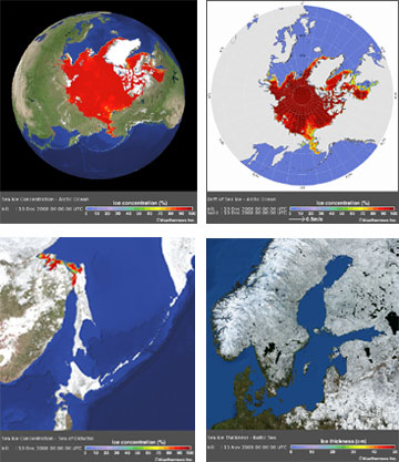
Weathernews launches Global Sea Ice Information website

Weathernews launches Global Sea Ice Information website

The Global Ice Center has been collecting and monitoring global sea ice data, including ice concentration, ice thickness and ice drift, since its opening in July 2008, in order to provide unified global sea ice information to shipping companies.

The Global Ice Center’s information covers such data as sea ice concentration, thickness and drift over not only the Arctic Sea, but also the Baltic Sea, the Sea of Okhotsk and the Gulf of Saint Lawrence.

Recently, sea ice data from the Global Ice Center was utilized for a successful and safe voyage through the Baltic Sea by an LNG tanker operated by one of the world’s major shipping companies.

In the near future, we will provide historical sea ice data, such as the first day of freezing, the first day of melting, the average rate and the largest amount of sea ice area.

Weathernews believes that our official Global Ice Center website is able to support many shipping vessels across the world, in order to contribute to the safe passage of the vessels that brave the icy waters of the Arctic Ocean.

[Major Characteristics of the Global Ice Center]

AnalysisThe Global Ice Center provides analysis information of sea ice conditions in all affected regions, using data from our original observation network and from organizations of various countries.

ForecastThe Global Ice Center original “I-SEE” model predicts sea ice concentration, thickness and movement out to two weeks, to support safe ship operation.

NetworkThe Global Ice Center, by using innovative technology in academia applied to sea ice data, is able to provide vital information to maritime companies, as well as feedback from ship reports.

Weathernews Inc. is the world's largest private weather service company headquartered in Japan. It is the only global weather content maker that employs over 600 staff (including more than 200 meteorologists) in offices in 32 cities in 16 countries and regions, including United States, United Kingdom, Germany, Netherlands, Italy, France, Spain, Australia, China, Japan, Korea, Malaysia, India, Nepal and Taiwan.

WEATHER NOTE

Waterspout causes chaos for boaties

A boating couple from the Coromandel Peninsula who were singled out by a freak of nature on the first day of their holiday have not been put off the lifestyle.

Anne Louden and her husband John were watching an electrical storm last night from their anchorage off Great Barrier Island, when the sky became dark. Just as they went below deck, a water spout picked up their nine metre launch, threw it into the air and dumped it back down. The couple suffered only a few cuts and bruises.

Ms Louden says she has seen disasters on TV and could not imagine ever being part of such an event.

"It's just one of those weird, freaky things that happens. You can't be put off boating, you really can't, it's a spectacular lifestyle. But it gives you an appreciation of weather and caution."
Ms Louden says none of the other 30 or so boats in the bay were touched.

Waterspouts occur when layers of high, cool air blow over a body of water such as a lake, river or ocean sweeping up moist air from below.

Tornado Intercept Audio


MARITIME NOTE

Lack of systems training poses threat to shipping
Electronic navigation aids are not being properly used, says marine safety body


The UK's sea safety body has warned that computerised navigation systems are steering large vessels into dangerous shallows because officers have insufficient training in their use.

The Department for Transport's Marine Accident Investigation Branch (MAIB) sounded the alert after over-reliance on an incorrectly used Electronic Chart Display Information System (ECDIS) resulted in the temporary grounding of the cargo ship Performer on Harborough Sand on its way to Grimsby in May 2008.

A subsequent investigation by MAIB warned: "The use of ECDIS has steadily increased in recent years, and it is disturbing that the number of accidents resulting from the incorrect use of ECDIS and ECS [Electronic Chart Systems] through poor system knowledge has also risen.

"ECDIS will soon replace paper charts as the primary planning and monitoring media onboard most vessels, but the system can only realise its potential benefits to maritime safety if all mariners who are expected to use the equipment at sea are properly trained."

Many ships' officers, including the master of Performer, were only formally trained in the use of paper charts, although many have used electronic aids. An ECDIS installed in 2007 was Performer's primary means of navigation, but none of her bridge watchkeeping officers had been trained in its use.

MAIB cited a number of accidents in recent years in which misuse of ECDIS or ECS has been a contributing factor, including a cross-Channel ferry that headed for shallows in 2004 without its ECDIS issuing a warning because it had not been correctly set up.

And in January last year a vessel hit a submerged wreck near Dover, severely damaging her propellers, because the wreck was not shown on the ECS display. "The need for mandatory training in ECDIS is compelling," said the MAIB report.

Proposed international regulations require ECDIS in most large new passenger vessels and large cargo boats and tankers, and its retro-fit over time to existing vessels.

Dangers At Sea


January 2009...gone already! Have a great weekend!
RS

Thursday, January 29, 2009

Great Lakes Water Levels Sensitive To Climate Change

Great Lakes Water Levels Sensitive To Climate Change

ScienceDaily (Jan. 14, 2009) — The water level in the Great Lakes has varied by only about two meters during the last century, helping them to play a vital role in the region's shipping, fishing, recreation and power generation industries.

But new evidence by scientists from the University of Rhode Island and colleagues in the U.S. and Canada, published recently in the journal Eos, indicates that the water level in the lake system is highly sensitive to climate changes.

"In the distant past, there were great fluctuations in the water level of the Great Lakes, but it was thought to have been related entirely to the advance and retreat of the glaciers," said URI geological oceanographer John King, who led the study with URI visiting scientist Michael Lewis, emeritus scientist with the Geological Survey of Canada. "But the last time lake levels fell dramatically – down to 20 meters below the basin overflow outlets – it was due to dry climate conditions."

That event, which occurred between 7900 and 7500 years ago in the early Holocene period, caused the lakes to become disconnected as their overflow rivers, including the Niagara River, ran dry.

"People used to say that the oceans are so big, we can dump whatever we want in them and nothing will happen," said King. "They thought of the Great Lakes in the same way, that the system is too large to be sensitive to climate variations. But now we know that to be untrue. We've demonstrated that at least once in the last 10,000 years, climate drove the lake levels down pretty substantially."

Researchers had long assumed that the Great Lakes had been "hydrologically open" and connected since their formation 16,000 years ago during the retreat of the last ice sheet, but recent evidence has found this to be false. Ancient shorelines, submerged beaches, and tree stumps on the floor of some lakes indicate that the water line had been as much as 20 meters below the present lake level."We had a multi-proxy approach to this study, and through many lines of evidence we identified this as a dry interval with a climactic cause as opposed to a glacial-related cause," King said.

The climate and water levels in the Great Lakes region are determined by the interplay of three air masses: dry, cold Arctic air from the North, dry warm Pacific air from the West, and warm, moist tropical air from the Gulf of Mexico. The scientists found that during the period when lake levels receded significantly, the dry air from the Arctic and Pacific was dominant. Later, when precipitation from the tropical air mass became more frequent, the Great Lakes began to flow from one to another as they do today.

King worries about the economic impact to the Great Lakes region if the present climate changes lower water levels significantly. Navigation, water usage and hydropower would be severely affected.

"The climate interval that occurred back then is different from what we're going through now," King said. "It would take a pretty big change to close the basins again. But the sorts of temperatures and precipitation amounts that happened then are within the range of what is predicted for 2100. In the worst-case scenarios, a lot of things become possible.

"The range of lake-level changes that are likely to happen in the next 100 years is probably larger than the range of levels observed during the last century," he added.

WEATHER NOTE

Study links swings in North Atlantic oscillation variability to climate warming

Using a 218-year-long temperature record from a Bermuda brain coral, researchers at the Woods Hole Oceanographic Institution (WHOI) have created the first marine-based reconstruction showing the long-term behavior of one of the most important drivers of climate fluctuations in the North Atlantic.

The North Atlantic Oscillation (NAO) is a wide-ranging pressure seesaw that drives winter climate over much of North America, Europe and North Africa. Past reconstructions of the NAO have relied mainly on terrestrial, or land-based records, such as tree ring chronologies combined with ice cores and historical climate data. Those records do not fully capture oceanic processes linked to NAO variability, and short instrumental records from relatively few locations limit the understanding of ocean-atmosphere dynamics with regard to NAO behavior.

"By analyzing the coral, we were able to look at changes in the ocean relative to changes on land," said Nathalie Goodkin, lead author of the study published in the December issue of the journal Nature Geoscience. "Because they are slow growing and have long life-spans, corals can provide high resolution records that are well dated and centuries long."

As they grow, corals accrete seasonal and annual growth layers, similar to tree rings. The proportions of trace elements versus the major element (calcium) found in the layers of the skeleton largely depend on the temperature of the seawater in which it was formed. By analyzing the strontium to calcium ratio in the Bermuda brain coral, Goodkin and colleagues - WHOI scientists Konrad Hughen, Scott Doney and William Curry - were able to reconstruct monthly changes in ocean temperatures and evaluate variability of the NAO during both cold and warm periods from the Little Ice Age (1800�) to modern day.

The research team found the variability of the NAO decade-to-decade (multi-decadal scale) has been larger, swinging more wildly, during the late twentieth century than in the early 1800s, suggesting that variability is linked to the mean temperature of the Northern Hemisphere. This confirms variability previously reported in past terrestrial reconstructions.

"When the Industrial Revolution begins and atmospheric temperature becomes warmer, the NAO takes on a much stronger pattern in longer-term behavior," said Goodkin. "That was suspected before in the instrumental records, but this is the first time it has been documented in records from both the ocean and the atmosphere."

Safe driving in severe weather

The recent heavy frost will no doubt return again and again over the winter and early spring. Here is some advice for safer driving in severe weather:

* Drivers are reminded that rain and spray can reduce visibility and when the road is wet it can take up to twice as long to stop, so it makes sense to slow down when it's raining.

* Surface water may affect motorways and major A roads so we advise drivers to move slowly through any standing water and test their brakes once they're through before continuing to drive.

* High-sided vehicles are particularly affected by windy weather but strong gusts can also blow any vehicle, cyclist, motorcyclist, or horse rider off course. This can happen on open stretches of road exposed to strong crosswinds, or when passing bridges and high-sided vehicles.

* Plan journeys. Check the weather forecast, road conditions, and the route for delays before leaving home and delay travelling if the weather becomes severe.

* Drivers are also advised to carry warm clothing and an emergency pack, which includes food and water, boots, de-icer, a torch, a spade if snow is forecast, and to make sure they have plenty of fuel for the journey.

MARITIME NOTE

Time to reboot maritime’s image, retired New Orleans port exec says

Retired port executive Ron Brinson said the Charleston maritime community should take the rapt attention that Maersk’s decision to leave has thrust on the port and turn it into a better understanding of the industry.

“The public does not understand and does not appreciate the value of the port,” Brinson said Thursday to a crowded room at the Charleston Motor Carriers Association’s monthly luncheon at the Sheraton in North Charleston.

Because of that misunderstanding, Brinson said, “we have a port that has been competing with one hand tied behind its back.”

Brinson, now living in Charleston, retired from the business in 2003 after more than 15 years as president and CEO of the Port of New Orleans. A former newspaper editor and reporter in Charleston, Brinson also worked for the S.C. State Ports Authority before leaving for Louisiana.

Much of Brinson’s talk focused on the fallout caused by Maersk Line’s announcement that it would begin pulling services out of Charleston early this year and completely leave town when its contract expires at the end of 2010.

Although the Danish company’s business is extremely important to Charleston and the entire state, the community should not take the news personally, Brinson said.

“These are unemotional business decisions that we sometimes tend to make emotional,” Brinson said.

Charleston, he noted, isn’t the first community to deal with the loss of Maersk, the world’s largest steamship line and the S.C. State Ports Authority’s largest customer.

In 1999, Maersk left the Port of Long Beach in California because officials there could not or would not agree to concessions the shipping company said it needed.

It took about three years, but Long Beach recovered after losing 25% of its business to competitor Los Angeles.

Brinson also warned the group not to heap blame on the International Longshoremen’s Association. Anti-union sentiment seems to have grown stronger nationally in the wake of Detroit’s struggles, he said, and seems even more intense in Southern states, including South Carolina.

The Maersk decision also compounded those feelings because the company said it was moving because the ILA refused to let the company operate from the common-user yard at the Wando Welch Terminal, a move that would have eliminated several dozen union jobs.

People, especially in South Carolina, tend to perceive unions as a four-letter word, he said. “The reality is that unions are a four-letter word at our port, and that word is F-A-C-T.”

In Charleston, he said, union labor has a good reputation. The SPA has a good reputation also, he said, and offered this advice: “Ease up; give the ports authority a little breathing room.”

He had some advice for port executives as well. Brinson said they should be willing to try new operating models and not wait for changes — potentially misguided changes — to be forced upon the port by the General Assembly and governor.

And he suggested that the entire maritime community, including SPA staff members, spend time “rebooting” relationships with the public. If the state is giving off the perception that it does not support its port operations, steamship lines might take the cue and send their business elsewhere.

“Maybe we South Carolinians are sending the wrong message to the marketplace,” he said.

RS

Wednesday, January 28, 2009

NOAA: 2008 Global Temperature Ties as Eighth Warmest on Record

NOAA: 2008 Global Temperature Ties as Eighth Warmest on Record

The year 2008 tied with 2001 as the eighth warmest year on record for the Earth, based on the combined average of worldwide land and ocean surface temperatures through December, according to a preliminary analysis by NOAA’s National Climatic Data Center in Asheville, N.C.

For December alone, the month also ranked as the eighth warmest globally, for the combined land and ocean surface temperature. The assessment is based on records dating back to 1880.

The analyses in NCDC’s global reports are based on preliminary data, which are subject to revision. Additional quality control is applied to the data when late reports are received several weeks after the end of the month and as increased scientific methods improve NCDC’s processing algorithms.

NCDC’s ranking of 2008 as the eighth warmest year compares to a ranking of ninth warmest based on an analysis by NASA’s Goddard Institute for Space Studies.

The NOAA and NASA analyses differ slightly in methodology, but both use data from NOAA's National Climatic Data Center – the federal government's official source for climate data.

Global Temperature Highlights – 2008

The combined global land and ocean surface temperature from January-December was 0.88 degree F (0.49 degree C) above the 20th Century average of 57.0 degrees F (13.9 degrees C). Since 1880, the annual combined global land and ocean surface temperature has increased at a rate of 0.09 degree F (0.05 degree C) per decade. This rate has increased to 0.29 degree F (0.16 degree C) per decade over the past 30 years.

Separately, the global land surface temperature for 2008, through December, was sixth warmest, with an average temperature 1.46 degrees F (0.81 degree C) above the 20th Century average of 47.3 degrees F (8.5 degrees C).

Also separately, the global ocean surface temperature for 2008, through December, was 0.67 degree F (0.37 degree C) above the 20th Century average of 60.9 degrees F (16.1 degrees C) and ranked tenth warmest.

Global Temperature Highlights – December 2008

The December combined global land and ocean surface temperature was 0.86 degree F (0.48 degree C) above the 20th Century average of 54.0 degrees F (12.2 degrees C).

Separately, the December 2008 global land surface temperature was 1.22 degrees F (0.68 degree C) above the 20th Century average of 38.7 degrees F (3.7 degrees C) and ranked 14th warmest.

For December, the global ocean surface temperature was 0.74 degree F (0.41 degree C) above the 20th Century average of 60.4 degrees F (15.7 degrees C) and tied with December 2001 and December 2005 as sixth warmest.

Other Global Highlights for 2008

The United States recorded a preliminary total of 1,690 tornadoes during 2008, which is well above the 10-year average of 1,270 and ranks as the second highest annual total since reliable records began in 1953. The high number of tornado-related fatalities during the first half of the year made 2008 the 10th deadliest with a 2008 total of 125 deaths.

Northern Hemisphere snow cover extent in December was 16.95 million square miles (43.91 million square kilometers). This was 0.17 million square miles (0.43 million square kilometers) above the 1966-2008 December average. Northern Hemisphere snow cover extent was below average for most of 2008.

Arctic sea ice extent in 2008 reached its second lowest melt season extent on record in September. The minimum of 1.80 million square miles (4.67 million square kilometers) was 0.80 million square miles (2.09 million square kilometers) below the 1979-2000 average minimum extent.

NOAA understands and predicts changes in the Earth's environment, from the depths of the ocean to the surface of the sun, and conserves and manages our coastal and marine resources.

WEATHER NOTE

Officials send letter to Coast Guard asking for thorough investigation

Gloucester - The following letter was sent on Jan. 9 to Rear Admiral Dale Gabel, First Coast Guard District, Boston:

Dear Rear Admiral Gable,

We are writing to seek your assistance with an urgent request regarding the recent tragic loss of the Gloucester fishing vessel Patriot. In the wake of this incident, which claimed the lives of experienced fishermen Matteo Russo and Giovanni Orlando, thorough answers to many questions are necessary.

We are award that the Coast Guard has initiated an investigation into this incident, and that the First District and Sector Boston personnel are continuing to examine available information regarding all of the factors involved in the loss of the Patriot. We urge you to maintain and intensify this effort, and to expedite it as much as possible.

Yet we firmly believe that the information surrounding the loss must be significantly expanded to include the position, condition and all other pertinent facts available from examination of the Patriot in its present position. We thus request, in the strongest possible terms, that the Coast Guard undertake an underwater investigation of the vessel as soon as possible, utilizing either professional divers and/or submersible vehicles.

We are aware that this request is extraordinary, but yet this incident is as well. Thorough answers, to the extent possible must be developed to the haunting questions that remain.

Among those questions are how a sound vessel, with an experienced crew could so suddenly be lost in the sea and weather state that existed on Jan. 1 and 2. Understanding what led to the loss of the Patriot and Matteo Russo and Giovanni Orlando is critical, and conducting a subsurface investigation will yield answers that are vital for investigators, other Coast Guard personnel, the families of those who have been lost, those who must return to sea as fishermen, and the public.

Accordingly, please initiate such an investigation as soon as it may be undertaken. Thank you for your consideration of this request, and please do not hesitate to contact us if we may be of any further assistance, or to discuss this matter further.

Sincerely
State Sen. Bruce Tarr
State Rep. Ann-Margaret Ferrante
Mayor Carolyn Kirk

Cc: Sen. Kennedy, Sen. Kerry, Rep. Tierney


MARITIME NOTE

Coast Guard reminds mariners to prepare, exercise caution in high surf

HONOLULU — The U.S. Coast Guard warns boaters and beach goers to exercise caution in all Hawaiian waters for the next few days due to potentially high winds and coastal area flooding.
The Coast Guard reminds all who work and play in island waters that conditions may be more dangerous during potentially high surf conditions.

In addition, marinas and boaters are reminded to check that boats in port are properly secured, bilge pumps are functional, and all loose items are removed from decks. Report any boats adrift, pollution or other maritime emergencies to the Coast Guard Sector Honolulu Command Center at 808-842-2600 or to the National Response Center at 800-424-8802.

The National Weather Service — www.noaa.gov — has posted hazardous weather outlooks for the entire state of Hawaii to include gale force wind warnings, small craft advisories and high surf advisories. The boating public is strongly encouraged to pay close attention to local weather forecasts before leaving port.

Here are some tips for those who choose to go out on the water during the potentially heavy weather:

Leave a float plan with a responsible individual who knows your intentions, location and who they should call if you do not return as scheduled.

Wear a Coast Guard-approved life jacket and set the example for your passengers or paddling partners.

Carry a marine band VHF radio and/or other reliable means of communication.

Be prepared for the shock of sudden immersion and the disabling effects of cold water. Plan for the worst: dress as though you are going to get wet and be cold.

Maintain awareness on the water — be aware of activity around your vessel including changing weather, and always know your location.

Be responsible — know that alcohol and drugs cause accidents and sometimes death.

Don’t boat alone — boating alone is not recommended. Recreational paddlers canoeists and kayakers often travel with a single craft and one partner, or even solo, but it is recommended you canoe, kayak or boat with at least three people or two craft.

Know your limitations paddle — be honest with yourself and your companions. Your life and the lives of those in your party may depend on how everyone understands each other’s capabilities.

Tags: , ,

M.V. New Carissa Wreck Removal TITAN


RS

Tuesday, January 27, 2009

New Zealand Tries to Avoid a Rescue Bill

New Zealand Tries to Avoid a Rescue Bill

From the The Antarctica Blog

Tourism in Antarctica isn't like tourism in other extreme environments - in some ways, it's much more dangerous.

Take any indicator - temperature, ocean conditions, accessibility - and Antarctica in a sense wins because it is colder, icier, and more difficult to get to than anywhere else. So it makes sense that New Zealand would try to block an adventurous rower from his plans to row around Antarctica by himself.

Maritime New Zealand (MNZ), the branch of government responsible for marine safety, would be responsible for rescuing the rower, Oliver Hicks, in case of an accident. MNZ believes that an accident is almost inevitable because of the harsh conditions on the Southern Ocean. Hicks will be using a boat that is powered by rowing but has cabins in which he can sleep, prepare food, and store supplies.

The boat is also allegedly designed to withstand Southern Ocean conditions.MNZ has great reason to be skeptical of Hicks' plans, however.

Previous attempts have resulted in accidents requiring rescue, and in one case an adventurer drowned. Rescue missions are costly and put rescuers themselves in danger. Hicks' journey would take him 500 days and would cover 24,000 square kilometers, or just under 15,000 miles.

He plans to halt for a few months during the brutal Antarctic winter on the island of South Georgia.Hicks' response to New Zealand's refusal to let him set out on his journey was to travel to Australia.

Australian officials are hardly excited about the project, but unlike their New Zealand counterparts cannot stop him from leaving. If he needs rescuing, MNZ will still be on the hook.

Hicks has already accomplished some impressive feats of solo rowing - he is the only person to have rowed from America to the United Kingdom alone - and feels confident that he is capable of completing his mission and staying safe.This incident underscores the need for special tourism policies for Antarctica.

The human desire to undertake difficult and dangerous adventures is admirable, but is disregarding the wishes of those who would have to rescue you also admirable? It's not as if MNZ could just ignore Hicks in the event of an accident, even if he wanted them to do so. It seems a shame that governments are hamstrung in this way.

While this type of tourism doesn't represent the kind of environmental threat that we at ASOC are most concerned about, it does point to the overall lack of regulation for Antarctic tourism that would protect both people and the environment.

Laws and rules no doubt deaden the souls of expeditioners, but they keep people safe and prevent unnecessary crises.

Posted by Antarctic and Southern Ocean Coalition at 7:31 AM

WEATHER NOTE

Fight against historic flood protects city

Record flooding of the Stillaguamish River filled low-lying areas south of the Stanwood city limits, leaving Marine Drive under more than 3 feet of water last week.

“It was close,” said Stanwood Camano Fire and Rescue (SCFR) Chief Mike Ganz Friday morning. “We are finally out of the woods.”

River gauges showed the Stillaguamish to be at or near record depth by 6 p.m. Thursday. An emergency earthen wall along SR 532 held back the cresting flood, and with the cooperation of Burlington Northern Santa Fe (BNSF), the city sandbagged the tracks and Marine Drive to keep east Stanwood dry.

By Thursday evening, the governor’s office had declared a state of emergency for most of Snohomish County.

On Friday morning, it seemed as if the worst had passed.

After consultation with BNSF officials, tracks were reopened by 10 a.m. On Monday, Fort Freberg, a 7-foot-tall emergency dike named for retired firefighter Jack Freberg, still stands as a reminder of the Herculean effort that saved the city.

Mike Simmons, SCFR emergency manager, said he is in no hurry to remove the fortification. “You really don’t want to pull these things down too quickly,” said Simmons. Ganz credits the volunteers who worked alongside city and emergency crews.

“These folks — they’re awesome,” he said. “They did a fantastic job.”

According to Ganz, many different agencies and individuals — some from other counties — worked hand-in-hand to prevent a tragedy.

In addition, inmate work crews from Monroe Correctional Complex worked with city crews filling sandbags and providing them to residents.

U.S. Army Corps of Engineers worked alongside city and county crews to shore up temporary protective dikes and repair levees.

“They helped plug a break near 95th Avenue NW,” said Ganz. Rebecca Hover, Snohomish County Sheriff’s Office public information officer, said rescue teams were deployed swiftly to prevent the loss of life.

“We responded to dozens of calls, but it’s impossible to say how many calls we went on or how many people we rescued — there’s really no way to keep count,” said Hover. “Rescuers would get a call to go to one house to help people out and then they’d find more people who needed help out of the area or neighborhood.”

Most of the calls involved people needing help out of their houses or businesses; they also helped people who got stuck in their vehicles as they tried to drive through the flood waters, she said.

Christian Davis, North County Fire/EMS public information officer, said their crews were kept busy with rescue operations.

“We had nine water rescue calls, with 14 victims removed from the flooded areas,” said Davis. “We (also) assisted with a sandbagging request by DEM (Department of Emergency Management) for the city of Stanwood.”

One unique moment, said Davis, was when a 100-gallon propane tank washed up on the shore in the Warm Beach area.

Crews secured the tank, stopped the leak and notified a company for its removal, he said. Stanwood’s emergency operations center went into action Wednesday morning and remained open until 4 p.m. Friday.

“The final damage estimates haven’t come in yet,” said Simmons. “Within the city limits, it will probably be very low.”

Most of the real damage happened to homes and farms south of Stanwood, he said. For many, the days and weeks ahead will mean clean-up and salvage operations. Claims for assistance should be started immediately, said Simmons. Only damage from the floods occurring on or after Jan. 6 should be reported.

“The primary focus now is to compile damage reports from Snohomish County residents and businesses to qualify for federal disaster aid and speed relief to our citizens,” he said.

“Do not wait for a professional estimate of cost or an insurance adjustor document to fill these forms out.”

Receding water has allowed for the reopening of Marine Drive, but several streets remained navigable only by boat at NEWS deadline.

Dianne White, Stanwood mayor, said she is filled with pride after witnessing the ‘flood fight’ play out.

“The flood was an event that showcased the quality of the citizens of Stanwood,” she said. The seamless response of emergency crews and the scope of volunteerism prevented disaster on a wider scale, she said.

“Without the help of the Army Corps of Engineers, we would have lost our waste water treatment plant,” said White.

Flood waters entered offices at the plant, though damages are reported as minimal. Water processing and quality were not affected.

“The fire department’s Support 99 group as well as the Salvation Army worked tirelessly to meet the needs of victims, volunteers and EOC workers throughout the event,” she said. White applauded the efforts of Red Cross volunteers, Stanwood/Camano School District personnel and staff from Josephine care facility whose residents were evacuated to Stanwood High School.

“What distinguishes Stanwood is the ‘can do’ attitude of our citizens and businesses,” said White. “We had over 400 sandbag volunteers, who filled bags at Index Sensors and Twin City Foods parking lots.”

White said she is grateful for food provided to volunteers by QFC, the family of Carolyn Lund, and numerous citizens.

Flood gates erected to help drain the flood performed better than expected. On Friday, the gates were draining at 1,500 cubic feet per second and lowered the flood water by 46 inches in one day.

“This new addition to our flood fighting arsenal is serving to get Marine Drive and the railroad tracks open much sooner than past years,” she said. “The Stillaguamish Flood District and Max Albert are to be commended for their persistence in getting this structure built.”

Chuck Hazleton, Stillaguamish Flood Control District commissioner, said he was overwhelmed by the success of the flood control gates in operation near Marine Drive.

“The flood gates are working better than we had expected,” said Hazelton. “The velocity of the discharge is more than we anticipated.”

Built in September 2007, the control system — a concrete structure — has 10 gates to create a nonporous channel back into the river.

The overall project cost $175,000, and the city subsidized $30,000 towards the construction of the gated system.

“It was definitely money well spent,” said Hazelton.

Sen. Mary Margaret Haugen (D), of Camano Island, said the legacy of this flood event will be how residents saved their city.

“One of the merits of living in a small community is how your neighbors reach out to help,” said Haugen. “I am so proud of the way people in the Stanwood area rallied to help each other.”

Haugen said she believes Stanwood was spared because of all the people who helped. “It's really tragic how many people in our state were affected,” she said. “You just can't imagine how bad this is until you've experienced it.”

The flooding was yet another blow to a region already hit hard by bad weather, said Haugen.

MARITIME NOTE

Coast Guard warns mariners be aware of ice conditions in Delaware Bay

PHILADELPHIA - The Coast Guard Captain of the Port Sector Delaware Bay in Philadelphia has set ice condition three Thursday and is warning mariners to be aware of ice in the Delaware Bay and River.

Ice condition three is set when weather conditions are favorable for the formation of ice in navigable waters. All masters, ship agents, and owners and operators of all vessels, marine facilities and marinas should review and adhere to the seasonal ice procedures listed below. These criteria were developed in partnership with the Mariners’ Advisory Committee for the Delaware Bay and River. Ship agents should generally act as liaison between the Coast Guard and their vessels.

When ice is present, but less than two inches, vessels must have a propulsion system with a minimum of 1000 horsepower, and be able to maneuver un-assisted through the ice without needing to stop, back off and ram the ice.

When ice is present in the C and D canal, only steel-hulled vessels whose propulsion systems are in excess of 1000 horsepower may transit the canal.

Vessel convoys will not be directed for ice or ice build of less than two inches, provided vessels can maintain headway. For ice conditions of two inches or greater, the Captain of the Port, in conjunction with the MAC, will consider implementing a plan that includes directing vessel convoys.

Vessel moorings should be checked frequently to ensure the vessel is adequately moored.

Vessels at anchor should maintain their engines on standby at all times.

Vessels at anchor should ensure that proper bridge watches are stood at all times.

Vessel sea chests should be checked regularly for ice buildup and precautions should be taken to ensure that the sea chests are kept clear.

The Captain of the Port Sector Delaware Bay may establish additional requirements for specific geographic areas of the Captain of the Port Zone if conditions warrant such restrictions.

Please refer to the Sector Delaware Bay website for additional information regarding ice operations within the Sector Delaware Bay zone at http://www.uscg.mil/d5/sectDelawarebay or by calling our Sector Delaware Bay ice line at (215)-271-4995.

If you have any questions regarding the contents of this bulletin or the expectations of the Captain of the Port, please contact the Waterways Management staff at (215) 271-4889 or the Situational Unit Controller at (215) 271-4807.

Marine Salvage Basics


RS

Thursday, January 15, 2009

Boaters say proposals cast them adrift

Boaters say proposals cast them adrift

Proposed changes to the Nanaimo Port Authority’s moorage policy could force some liveaboards to weigh anchor and leave home port in their wake.

The proposed changes include a 14-day anchoring restriction within a 30-day period, a six-month extended stay permit, and requirements for holding tanks and logs for sewage discharge, as well as insurance.

People have until Feb. 2 to comment on the proposals.

Many liveaboards like Brunie Brunie, 66, and Norman Brook, 51, have called Nanaimo home for 10 or more years and say they won’t leave.

“I will fight to the death,” said Brunie, who has lived aboard her 1939 Lapstrake, MagicMade, for more than 20 years. “If they’re going to kick me off, they’re going to have to do it and blow me out of the water, and I’ll get all the TV cameras there when they do it.”

Brook, who has lived in the harbour for more than 12 years, said harbour residents could take the matter to court.

“We’ll have to fight it in court because this is precedent setting. If they do it here, there is nothing to stop it happening everywhere in Canada,” he said.

Andrew Pitcher, harbour master and manager of operations for the Port Authority, said the changes are to make people more responsible for their vessels. Pitcher said some changes are proposed because of boats running aground and the NPA left footing the bill.

Last year, the authority salvaged two boats at Newcastle Island, costing $40,000. “Most of the time when we [salvage a boat], the owner just walks away from the boat,” said Pitcher.

Brook and Brunie said the proposals are over-regulating. They say requiring insurance is a way for the port to get rid of liveaboards, because many can’t afford it.

The proposal would require $1 million third party liability and an additional $500,000 of pollution liability insurance if the vessel’s fuel capacity is more than 100 litres. The owner would have to have coverage for the entire stay in the harbour.

“We can’t comply with the insurance so it’s not only kicking our house out of the water, but our business has to leave too,” said Brook, who operates NAB Marine Electrical and Shipwrighting from his vessel.

Pitcher said if feedback indicates the insurance is too costly, the port will re- examine the proposals.

“We have to listen to public input,” he said.

Brook is a member of the Nanaimo Harbour Boater Community, an organization of 54 boaters, including 26 liveaboards and several boaters who moor their vessels in the harbour and live in the area.

Brook said if the organization hadn’t formed, the boaters would already have been forced out of the harbour.

But both Brunie and Brook support the requirement to have a holding tank to discharge sewage in approved facilities.

“The ocean is our yard. We respect it ... we are totally for that because we don’t want to be dumping in our yard,” said Brook.The proposed changes are online at www.npa.ca or at the NPA office at 104 Front Street.

Pitcher said there has been both positive and negative feedback so far.

After the Feb. 2 input deadline, the port authority will review comments and redraft the proposal.

WEATHER NOTE
Rescues, injuries as big seas hit coast

Lifesavers had a busy day on south-east Queensland beaches as king tides created sudden and dangerous rips.

Thirteen people were pulled from the surf at Surfers Paradise and another five rescues were necessary along other Gold Coast beaches.First aid was given to five surfers, two of whom were hospitalised with neck and shoulder injuries.On the Sunshine Coast, a shark sighting saw beaches at Maroochydore and Alexandra Headland closed for the remainder of the day.A report of two girls missing on an unpatrolled beach at Coolum sparked a two-and-a-half hour search which proved fruitless.

Surf lifesaving spokeswoman Kaitlyn Akers said there was no evidence on the beach of the girl's presence and the search was called off.Another pair of females had to be rescued after they were swept 200 metres out to sea when they entered the water into a rip.

"They didn't walk an extra 50 metres to the flagged patrolled area and walked straight into a rip,'' Ms Akers said.Another two surfers were taken to hospital as a precaution after sustaining head injuries in the wild surf.Ms Akers said conditions were improving on all but those beaches exposed to south-east winds.

She urged swimmers to stay between the flags."We set the flags where we do for a reason,'' Ms Akers said.

MARITIME NOTE
Coast Guard swimmer receives medal for rescues
The News Journal

The Coast Guard awarded it’s Air Medal today to one of its own for his role in two rescues off Delaware and Maryland.

Petty Officer 2nd Class Tye Conklin, a rescue swimmer from the Atlantic City air station, received the medal at the Hughes Technical Center in Pomona, N.J. Capt. Paul Ratte, commanding officer of the air station, made the presentation.Conklin rescued two crewman from the research boat Russell W. Peterson on May 12.

The Peterson had been 14 miles off Rehoboth Beach, its legs screwed into the ocean floor as the crew collected data on migratory bird patterns for Bluewater Wind LLC's proposed offshore wind farm, when a coastal storm slammed the mid-Atlantic area.

The captain of the Peterson, 61-year-old John Moyse, died. The boat later ran aground at Bethany Beach.Conklin also rescued one person from a sailboat that ran aground off Ocean City, Md., the Coast Guard reported in a news release.


RS

Tuesday, December 30, 2008

Oscillation Rules as the Pacific Cools

Oscillation Rules as the Pacific Cools

PASADENA, Calif. -- The latest image of sea-surface height measurements from the U.S./French Jason-1 oceanography satellite shows the Pacific Ocean remains locked in a strong, cool phase of the Pacific Decadal Oscillation, a large, long-lived pattern of climate variability in the Pacific associated with a general cooling of Pacific waters. The image also confirms that El Niño and La Niña remain absent from the tropical Pacific.

The new image is available online at: http://www.nasa.gov/topics/earth/features/20081209.html.

The image is based on the average of 10 days of data centered on Nov. 15, 2008, compared to the long-term average of observations from 1993 through 2008. In the image, places where the Pacific sea-surface height is higher (warmer) than normal are yellow and red, and places where the sea surface is lower (cooler) than normal are blue and purple. Green shows where conditions are near normal. Sea-surface height is an indicator of the heat content of the upper ocean.

The Pacific Decadal Oscillation is a long-term fluctuation of the Pacific Ocean that waxes and wanes between cool and warm phases approximately every five to 20 years. In the present cool phase, higher-than-normal sea-surface heights caused by warm water form a horseshoe pattern that connects the north, west and southern Pacific. This is in contrast to a cool wedge of lower-than-normal sea-surface heights spreading from the Americas into the eastern equatorial Pacific. During most of the 1980s and 1990s, the Pacific was locked in the oscillation's warm phase, during which these warm and cool regions are reversed. For an explanation of the Pacific Decadal Oscillation and its present state, see: http://jisao.washington.edu/pdo/ and http://www.esr.org/pdo_index.html .

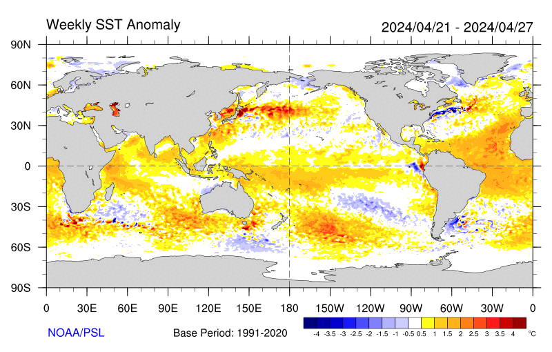
Sea-surface temperature satellite data from the National Oceanic and Atmospheric Administration mirror Jason sea-surface height measurements, clearly showing a cool Pacific Decadal Oscillation pattern, as seen at: http://www.cdc.noaa.gov/map/images/sst/sst.anom.gif.

"This multi-year Pacific Decadal Oscillation 'cool' trend can cause La Niña-like impacts around the Pacific basin," said Bill Patzert, an oceanographer and climatologist at NASA's Jet Propulsion Laboratory, Pasadena, Calif. “The present cool phase of the Pacific Decadal Oscillation will have significant implications for shifts in marine ecosystems, and for land temperature and rainfall patterns around the Pacific basin.”

According to Nathan Mantua of the Climate Impacts Group at the University of Washington, Seattle, whose research contributed to the early understanding of the Pacific Decadal Oscillation, "Even with the strong La Niña event fading in the tropics last spring, the North Pacific's sea surface temperature anomaly pattern has remained strongly negative since last fall. This cool phase will likely persist this winter and, perhaps, beyond. Historically, this situation has been associated with favorable ocean conditions for the return of U.S. west coast Coho and Chinook salmon, but it translates to low odds for abundant winter/spring precipitation in the southwest (including Southern California)."

Jason's follow-on mission, the Ocean Surface Topography Mission/Jason-2, was successfully launched this past June and will extend to two decades the continuous data record of sea surface heights begun by Topex/Poseidon in 1992. The new mission has produced excellent data, which have recently been certified for operational use. Fully calibrated and validated data for science use will be released next spring.

JPL manages the U.S. portion of the Jason-1 mission for NASA's Science Mission Directorate, Washington. JPL is managed for NASA by the California Institute of Technology in Pasadena.

For more information on NASA's ocean surface topography missions, visit http://sealevel.jpl.nasa.gov/ . To view the latest Jason-1 data, visit http://sealevel.jpl.nasa.gov/science/jason1-quick-look/ .

WEATHER NOTE

Wave surge hits PNG


A huge wave has hit a Papua New Guinea island, submerging buildings and causing widespread damage but no casualties.

The giant wave hit Kavieng, on the New Ireland province, late on Tuesday and there were reports of a similar surge hitting PNG’s north-eastern coast province of East Sepik.

Details remain sketchy but one witness told AAP the water surge hit late this afternoon and disaster teams are now working through the damage.

“The wave took out the hospital and the east coast road of New Island,” local resident Nessie Amos said.

“The hospital’s equipment was washed out but patients were saved and taken to another hospital,” she said.

“There were no casualties but major damage was caused to the hospital and everything was washed out.”

Amos said one small island off Kavieng, Tents, is mostly under water and villagers have been moved to the neighbouring island of Emirau.

Government officials held a press conference in Wewak earlier this evening.

MARITIME NOTE

Report on Collision Death off Pt. Reyes

On Dec. 10, the U.S. Coast Guard released the results of two investigations. One report outlines the causes of the July 13, 2007 fatal collision between a cargo ship and a small fishing boat which occurred in heavy fog off Pt. Reyes, and the other is an internal review of the service's handling of the incident.

The incident involved the 291 ft motor vessel Eva Danielsen, a Bahamian-flagged cargo ship, and a 28 ft wooden fishing vessel, the Buona Madre, home ported in Santa Cruz, California. A collision between the two vessels resulted in the destruction of the fishing boat and the death of Mr. Paul Wade.

A Coast Guard Marine Casualty Investigation, which was conducted by San Francisco-based investigators and reviewed and released from Coast Guard headquarters in Washington D.C., found numerous factors contributing to the cause of the collision including: failure to ensure proper manning of the respective vessels in light of the prevailing weather conditions (heavy fog); and the freighter proceeding at an unsafe speed based upon the weather conditions, failing to follow applicable Navigational Rules of the Road (i.e., fog signals), and negligence with respect to the operation of the vessel.

An internal administrative investigation was also conducted by the 11th Coast Guard District to evaluate how Coast Guard policies and procedures were followed. The internal investigation found that some internal briefing requirements and communications processes were not followed. Several recommendations of the report have been adopted to improve management of communications among Coast Guard units including: Revision of Command Center Standard Operating Procedures to include recent CG policy changes; review and revision of all Quick Response Sheets (QRS) to ensure proper notifications are made in a timely fashion; Introduction of Search and Rescue fundamentals in the Coast Guard Vessel Traffic Service (VTS) training program; and cross training among various watch positions in the Coast Guard Sector Command Center and VTS.


RS

Tuesday, December 23, 2008

Ship-in-a-bottle Kit On A Microchip

Ship-in-a-bottle Kit On A Microchip

ScienceDaily (Dec. 9, 2008) Sometimes physicists resort to tried and trusted model-making tricks. Scientists at the Max Planck Institute for Metals Research, the University of Stuttgart and the Colorado School of Mines have constructed micromachines using the same trick that model makers use to get ships into a bottle where the masts and rigging of the sailing ship are not erected until it is in the bottle.

In the same way, the scientists link the valves, pumps and stirrers of a microlaboratory to create a micro device on a chip. To do this, they introduce colloidal particles - tiny magnetizable plastic spheres - as components into the channels on the chip. A rotating magnetic field is used to link the components into larger aggregates and set them into motion as micromachines.

In the future, biologists and chemists want to avoid using bulky glass flasks, Bunsen burners and magnetic stirrers as far as possible in their experiments. Similarly to microelectronics, where electrons are steered through tiny conducting paths, they intend to perform chemical reactions in microfluidic systems, that is, chambers and channels just a few micrometers in diameter. These "labs on a chip" will then allow DNA sequences or blood samples to be analyzed much more quickly and more efficiently. As they only require tiny amounts of liquids, this approach costs much less than traditional methods, which require larger quantities of materials. These micro analytical systems would also be transportable, because their core parts take up very little space. Paramedics, for example, could analyze blood samples at the site of an accident.

Researchers working with Clemens Bechinger who is a Professor at the University of Stuttgart and a Fellow at the Max Planck Institute for Metals Research, and David Marr, a professor at the Colorado School of Mines, have now found a new way to equip these miniaturized laboratories with moving parts and how to drive the tiny machines. They introduce colloidal particles, tiny plastic spheres with a diameter of just about five micrometers, into the channels and cavities on the chip.

As the particles contain iron oxide, they group together when they are magnetized by an external magnetic field. The scientists construct the magnetic field with four coils so that the microparticles are literally remote controlled and form diamond shapes or cog wheels. "The shape they assemble into depends crucially on the geometry of the channels," explains Tobias Sawetzki, who a doctoral student is working on the project. The microparticles then remain in this shape as long as the magnetic field is switched on.

The geometry also determines the function of the aggregates. By tipping backwards and forwards, a rhombus creates openings and acts like a valve. On the other hand, if it rotates in a chamber with two inflows, it mixes the incoming liquids. The micro stirrer is also driven by a magnetic field that rotates clockwise or anticlockwise parallel to the chip. In the same way, the researchers in Stuttgart roll a cog wheel through a channel with a serrated wall. The cog wheel, which completely shuts the channel off, agitates liquid back and forth and only in combination with two valves, acts like a pump.

"Compared to other approaches to equipping microlaboratories with moving parts, our ship-in-a-bottle technique has several advantages," says David Marr. Some scientists use pneumatic systems to pump liquids through microchannels, for example. However, this requires each component to be connected with a separate hose to the outside so that it can be supplied with compressed air. This is very complex and limits the integration density on microfluidic devices considerably, i.e. the total number of components on the chip.

With the new method, it is possible to accommodate up to 5,000 pumps on one square centimetre. Moreover, the new approach does not rely on elastic materials as are required for pneumatic pumps. "It is much easier to produce suitable chips for applications if they only consist of a single material, silicon, if at all possible," says Clemens Bechinger. As the electrical control components like the mini-coils can be fabricated based on silicon, it would be ideal to make the microchannels from the same material. This would allow for integration of all the components on one chip, as in microelectronics," says Bechinger.

Currently the researchers are still using large coils, so that all the components are driven by a single magnetic field and they all move in time with each other. However, this need not be a disadvantage as processes in many applications run in parallel; for example when the pharmaceutical industry searches for a new active ingredient amongst many thousands of substances. Furthermore, the researchers can choose the geometry of the channels so skilfully that different aggregates fulfil completely different functions in the same magnetic field. This means that the Stuttgart physicists’ method offers the option of driving a complex network of individual, standalone components with only one magnetic field.

WEATHER NOTE

National Weather Service recommends making preparations before the storm

Wausau Daily Herald

Now that winter is in full swing, the National Weather Service is reminding people to take precautions before a storm hits.

Items that should be kept at home and work:
• Flashlight and extra batteries.
• Battery-powered NOAA Weather Radio and commercial radio.
• Extra food and water. High energy food or food that requires no cooking is best.
• First-aid supplies.
• Emergency heating source, such as a fireplace or space heater -- make sure you have proper ventilation.

If possible, avoid driving during the storm. If you do:
• Check and winterize your vehicle before the winter season begins.
• Carry a winter storm survival kit that includes: blankets/sleeping bags, flashlight with extra batteries, first-aid kit, knife, high-calorie non-perishable food, extra clothing to keep dry, sand or cat litter, shovel, windshield scraper and brush, tool kit, and booster cables,
• Keep your gas tank near full to avoid ice in the tank and fuel lines.
• Try not to travel alone.
• Let others know your timetable and primary and alternate routes.

Where will NOAA go under the Obama Administration? OSU scientist could play a big role.


Andrew Freeman of the Washington Post blog “Capital Weather Gang” discussed potential changes at National Oceanic and Atmospheric Administration (NOAA) in his Monday, December 8th post. Why is this relevant to readers of H2ONCoast? Well, I am a Sea Grant Extension Specialist. Oregon Sea Grant’s federal mothership is NOAA, providing funds and guidance to how we do our jobs in Oregon. NOAA is not only important to the 30 Sea Grant programs around the country, but it guides research and applications to the study of climate, ocean science, fisheries, and weather among many other areas important to people living on the coast. Anyone who follows H2ONC should see that these topics are important ones to my own work and the work of many others in Oregon Sea Grant and OSU in general. Anywhere you hear words like Sea Grant, oceanography, drought, coastal zone management, coastal hazards, storms, marine fisheries, earth observation, weather or climate in the same sentence as government or research, you can bet that NOAA has something significant to do with it.

NOAA, however, is not a very “sexy” agency. It has few high-profile perks for the directors at the helm–other than rides in a hurricane hunting aircraft or first views of a new weather satellite’s output. Yet as I’ve said before, it is is immensely important to many. Here’s what Andrew Freeman had to say about the agency: Similar to the EPA and Interior Department, NOAA sits at the intersection of science and policy when it comes to numerous environmental issues — particularly climate change and oceans management.

Freeman noted that the past eight years have not been kind to NOAA or its programs: Following a turbulent eight years under President Bush, which featured allegations of political interference with NOAA scientific research, as well as cost overruns on a major environmental satellite program, the next few years are slated to be a rebuilding phase for NOAA; similar to a sports franchise that has hit a rough patch and needs an infusion of new talent and a morale boost. The question is whether the agency will come out a winner next season, or if it will struggle under new management. Much of that depends on who is selected to run the agency.

In a telephone interview on Friday, former NOAA Administrator D. James Baker, who led the agency for eight years under President Clinton, said NOAA is growing in importance due to the increasingly serious nature of environmental problems such as climate change.

Baker continued, “NOAA is the agency that monitors the pulse of the Earth and that told us that we are in danger because of climate change,” Baker said. According to him, the ideal candidate for administrator must possess a combination of scientific and political acumen, which is relatively rare. For example, both he and Conrad Lautenbacher, the most recent NOAA administrator who recently left that position, had backgrounds in oceanography among other scientific fields, as well as Washington experience.”

Baker dropped some names in play for that top slot. I’ve noted one that is a prominent OSU scientist.

  • Leon Panetta, former Democratic congressman from California, former chief of staff to President Bill Clinton and chair of the Pew Oceans Commission.
  • Former Interior Secretary Bruce Babbitt
  • Ralph Cicerone, President of the National Academy of Sciences
  • Marsha McNutt, CEO, Monterey Aquarium Research Institute
  • Jane Lubchenco, marine biologist and zoologist at Oregon State University
  • Rosina Bierbaum, Dean of the University of Michigan’s School of Natural Resources and co-director of a forthcoming World Bank report on climate change and development
  • Warren Washington, senior scientist at the National Center for Atmospheric Research
  • Michael S. Bruno, dean of the Charles V. Schaefer, Jr. School of Engineering
  • Richard Anthes, the director of the University Corporation for Atmospheric Research
  • Eileen Shea, currently the director of a NOAA center in Hawaii.

So, we will keep our eyes open on this one selection. While there are lots of important appointments and changes going on in Washington that make big news headlines, the “small ones” may count as very significant for communities as far away from the D.C. Beltway as the North Coast of Oregon. Let’s hope that this new administration’s choice of a new NOAA administrator means a new page for NOAA and its myriad locally-significant programs.

MARITIME NOTE

New maritime safety measures

By STAFF REPORTER
New measures have been drawn up which will improve safety measures for passengers travelling on Cyprus boats.

Minister of Communications and Works Nikos Nikolaides has welcomed the adoption of a new package of measures on maritime safety by the European Union Transport, Telecommunications and Energy (TTE) Council.

Speaking after the meeting, the minister said that the package strengthens the levels of vessel safety, as well as the protection of maritime environment and enhances the passengers’ rights regarding maritime transport.

“Being a country of important maritime infrastructure and know-how, [Cyprus] plays a leading role in shaping European maritime policy," he said.

"Cyprus, with its know-how and experience in the field of maritime transport, participated actively in drafting the third package of measures on maritime safety, since some of our positions, which aim at reinforcing the international maritime legislative framework and the international conventions, have been adopted."

A resolution on the European Data Center for the identification of vessels was also taken up.

Nikolaides called on the EU Commission, the European Maritime Safety Agency and EU member states to intensify their efforts for the conclusion of the European Data Center within the next six months.
(KYPE)

Ship firm calls jail term for tanker crew a 'disgrace'

SEOUL (AFP) — Managers of a Hong Kong supertanker whose crew chiefs were jailed over South Korea's worst oil spill have blasted the decision as a "disgrace and insult" to the world shipping community.

A South Korean appeal court, reversing a lower court decision, on Wednesday jailed the Indian captain Jasprit Chawla and chief officer Syam Chetan after ruling they were negligent in minimising the spillage.

The accident happened in December 2007 when a barge carrying a construction crane broke free after a cable to one of two tugs snapped in rough seas.

The barge rammed the anchored 147,000-ton tanker Hebei Spirit, holing it in three places and spilling 10,900 tons of crude oil.

V.Ships, which says it is the world's largest ship manager, said in a statement Thursday the court's decision "will surely go down as one of the most disgraceful examples of a miscarriage of justice in a 'supposedly' advanced nation state.

"For Captain Chawla and Chief Officer Chetan to be sentenced to prison terms and led from the court in handcuffs is a disgrace and insult to the whole shipping industry," it added.

The case has sparked anger among shipping operators and the International Transport Workers Federation (ITF), who insist the tanker crew were blameless.

The lower court in June had found them not guilty but prosecutors appealed the decision.

The International Association of Independent Tanker Owners has expressed "extreme dismay and disappointment" at Wednesday's ruling.

V.Ships said the ITF and its international membership are now "questioning whether it is safe for its members to travel on ships to Korea."

The lower court blamed barge operator Samsung Heavy Industries, part of the country's biggest business group, and the Korean tugboat skippers for the spill which fouled scores of marine farms and miles of beaches southwest of Seoul.

The appeal court in the central city of Daejeon agreed the Korean operators were mainly at fault and confirmed jail sentences on the tugboat skippers. But it said the tanker crew failed to take prompt action to abate the spillage.

Chawla was sentenced to 18 months in prison and fined 20 million won (14,000 dollars) while chief officer Syam Chetan was sentenced to eight months and fined 10 million won.

Their lawyers said they would appeal to the supreme court.

The ship's owner, Hong Kong-registered Hebei Ocean Shipping, was fined 30 million won.

V.Ships said the appeal court had relied on findings by the Korean Maritime Safety Tribunal (KMST ) which meant that "technically flawed, unreliable and unjust evidence" had been submitted to judges.

"In submitting their report, the KMST has demonstrated both its incompetence and an obvious desire to find fault with the officers of the Hebei Spirit," the management firm said.

"This blatant and totally unjustifiable case of criminalisation of a profession that we all rely upon for our international trade must not go unanswered by the international community and all those in the shipping industry.

CHRISTMAS AT SEA"
By Robert Louis Stevenson (1850-94).

http://www.sailorsrestcottage.com/images/christmasatsea.jpg

T
he sheets were frozen hard, and they cut the naked hand;
The decks were like a slide, where a seamen scarce could stand;
The wind was a nor'wester, blowing squally off the sea;
And cliffs and spouting breakers were the only things a-lee.

They heard the surf a-roaring before the break of day;
But 'twas only with the peep of light we saw how ill we lay.
We tumbled every hand on deck instanter, with a shout,
And we gave her the maintops'l, and stood by to go about.

All day we tacked and tacked between the South Head and the North;
All day we hauled the frozen sheets, and got no further forth;
All day as cold as charity, in bitter pain and dread,
For very life and nature we tacked from head to head.

We gave the South a wider berth, for there the tide-race roared;
But every tack we made we brought the North Head close aboard:
So's we saw the cliffs and houses, and the breakers running high,
And the coastguard in his garden, with his glass against his eye.

The frost was on the village roofs as white as ocean foam;
The good red fires were burning bright in every 'long-shore home;
The windows sparkled clear, and the chimneys volleyed out;
And I vow we sniffed the victuals as the vessel went about.

The bells upon the church were rung with a mighty jovial cheer;
For it's just that I should tell you how (of all days in the year)
This day of our adversity was blessed Christmas morn,
And the house above the coastguard's was the house where I was born.

O well I saw the pleasant room, the pleasant faces there,
My mother's silver spectacles, my father's silver hair;
And well I saw the firelight, like a flight of homely elves,
Go dancing round the china-plates that stand upon the shelves.

And well I knew the talk they had, the talk that was of me,
Of the shadow on the household and the son that went to sea;
And O the wicked fool I seemed, in every kind of way,
To be here and hauling frozen ropes on blessed Christmas Day.

They lit the high sea-light, and the dark began to fall.
"All hands to loose topgallant sails," I heard the captain call.
"By the Lord, she'll never stand it," our first mate Jackson, cried.
..."It's the one way or the other, Mr. Jackson," he replied.

She staggered to her bearings, but the sails were new and good,
And the ship smelt up to windward just as though she understood.
As the winter's day was ending, in the entry of the night,
We cleared the weary headland, and passed below the light.

And they heaved a mighty breath, every soul on board but me,
As they saw her nose again pointing handsome out to sea;
But all that I could think of, in the darkness and the cold,
Was just that I was leaving home and my folks were growing old.

2 More days til Christmas! http://library2.nalis.gov.tt/Portals/0/601/christmas%20tree.jpg
RS

Monday, December 8, 2008

Computers Determine When To Stop Searches For Missing People At Sea

Computers Determine When To Stop Searches For Missing People At Sea

ScienceDaily (Nov. 27, 2008) British researchers are developing a new computer model to predict how long someone will survive when lost at sea, which will in turn determine when a search and rescue operation may be stopped.

The Search and Rescue Survival Model is being developed by the University of Portsmouth’s Sports Science and Mathematics departments and the US Coast Guard.

It aims to support the US Coast Guard target of saving 93 per cent of victims annually - between 3000-6000 people - whose lives are in danger at sea.

“Using this new computer model will take pressure off humans making very emotional and sensitive decisions about when to end a search,” said Professor Mike Tipton, human and applied physiologist, from the University of Portsmouth.

“When the model predicts that a victim can no longer survive, the search and rescue team can stop or redeploy the search.

“It will ensure that Coast Guard personnel are not exposed to the high risks associated with search and rescue operations any longer than necessary and will also help to save time and resources,” he said.

The US Coast Guard currently uses a software system known as SAROPS (Search and Rescue Optimal Planning System) to calculate how far a person will have drifted and how large the search area should be.

Data such as wind speed, sea state and water temperature is entered into SAROPS along with information about the victim’s sex, height, weight and what they were wearing to determine exactly how the search should be conducted.

“Calculating survival time will add another layer to SAROPS; it will be able to predict not only where a search should be conducted but when it should be stopped,” said Professor Tipton.

Chris Turner, Ocean Engineer and Manager for the project for the US Coast Guard in Groton, Connecticut, sought the help of the university because of its international reputation for expertise in the area of survival in the sea.

“The University of Portsmouth has been able to tap into and analyze data held by the Institute of Naval Medicine and the Royal National Lifeboats Institution, both critical to the development of this survival model. To our knowledge no other similar repository of this information exists - even in the US.

“The development of this technology is very exciting. It will be trialled in American waters in late 2009 and once thoroughly tested, the aim is to roll it out to the whole of the US,” he said.

WEATHER NOTE

Weather disasters claimed 15,000 lives, report says

Stevie Emilia, The Jakarta Post, Poznan, Poland

More than 15,000 people across the world died last year from extreme weather, which also caused US$80 billion in damages, a report released Thursday at the ongoing UN climate change talks here revealed.

The Global Climate Risk Index 2009 by the environment and development group Germanwatch puts Bangladesh at the top of the list of countries most affected by weather-related disasters last year.

Bangladesh, which suffered heavily from cyclone Sidr that killed more than 4,000 people and caused $10 billion in damages, was followed by North Korea and Nicaragua.

Sven Harmeling, the group's senior advisor for climate and development, and author of the study, said many people had been severely affected by storms, floods and other weather extremes.

"People in less-developed countries have a far harder time coping with such events compared with their peers in industrialized countries," he said.

Hurricane Katrina caused $215 billion in damages when it devastated the U.S. Gulf Coast three years ago, making it the most expensive storm in history.

While no single weather disaster can be directly attributed to global warming, Harmeling warned the changing climate would most certainly lead to an increase in their frequency and intensity in many parts of the world.

The UN's Intergovernmental Panel on Climate Change earlier warned that climate change this year was likely to make extreme weather events more frequent and possibly more intense too.

Germanwatch, which first calculated the global climate risk in 2006, derived data for the present study from a database compiled by German insurance giant Munich Re.

The report analyzes how severely countries were affected in 2007 and in the past decade, or from 1998-2007, by weather-related events, including floods, heat waves and storms. It excluded droughts or sea-level rises -- long-term events that are harder to evaluate.

In the latest report, a total of 1,066 disasters were registered last year, causing 15,240 fatalities and economic losses of over $70.1 billion.

Indonesia came in at seventh place on the Down 10 list of countries with the highest death tolls, recording 470 deaths last year, and was ranked eight in the list of Down 10 countries with highest absolute losses, with a total of $3.09 billion.

"We're witnessing a strong increase in disasters, particularly the climate-related ones, in terms of the number of disasters, economic damage and people affected," said Maarten van Aalst, associated director of the Red Cross/Red Crescent Climate Center in The Hague.

"This is partly due to rising vulnerability, partly already reflecting global climate change, a trend which is bound to continue."

Apart from providing assistance when disaster strikes, van Aalst said the most effective response was disaster mitigation, stressing that "reducing the impact of the increasing hazards is crucial. Practical risk reduction options include better early warning, drought resistant crops or reforestation to prevent floods."

The report, which aims to give pointers about a country's vulnerability to climate change, proposes the inclusion of insurance instruments in the post-2012 regime.

In the Bali conference last December, the Bali Action Plan called for the "consideration of risk sharing and transfer mechanisms such as insurance" to deal with loss and damage in developing countries particularly vulnerable to climate change.

The ongoing Poznan conference serves as a bridge to the next conference, in Copenhagen, Denmark, to agree on a new deal to replace the climate treaty Kyoto Protocol, which expires in 2012.

"The Copenhagen treaty can introduce the necessary support mechanism with both prevention and insurance pillars," said Germanwatch executive director Christopher Bals.

"It is very positive that concrete proposals for risk management and insurance are today discussed in detail in Poznan."

Tornado confirmed in Palm Bay

BY KIMBERLY C. MOORE
FLORIDA TODAY

PALM BAY — National Weather Service meteorologists confirmed today that the windstorm that damaging more than a dozen homes in Palm Bay on Sunday was a tornado.

“It was kind of hopscotching,” National Weather Service meteorologist Scott Kelly said. “It did touch down, but it was very spotty. It was not a continuous track.”

Palm Bay residents spent Monday cleaning up their yards and dragging tree branches to the curb. Some homes had blue tarps on roofs. And contractors already were out, giving homeowners estimates to repair the damage.

Palm Bay officials did not yet have a dollar estimate of how much damage the tornado did.

No one was injured.

Keith Rittscher, 63, found the roof of his plastic shed near a neighbor’s home about 25 yards away from his Holiday Park house.

“That’s my roof,” he said, pointing to a tangled web of aluminum wedged into Australian pines behind his house.

Nearby, a collection of plastic pieces rested against his home’s back wall.

“This is my shed,” Rittscher said.

Rittscher estimated that damage to the home, which is uninsured for property damage, probably is about $20,000. He said he and his wife have enough to cover the cost.

“We’re OK,” he said.

The roof of one home on Emerson Drive at Consumer Street had several shingles ripped off.

Along Velvet and Ritter avenues on the east side of Interstate 95, residents picked up branches torn from trees and propped up trees knocked over by the powerful winds.

It was the same story east of Babcock Street, along Edith Street and Cambridge Avenue.

Kelly said Palm Bay got lucky. A stronger storm might have claimed lives.

“There could’ve been more chance for fatalities if trees had fallen on those homes,” he said.

In Holiday Park, a community of manufactured homes, Don Clark spent the morning with two contractors, getting bids for his roof.

A blue tarp now is tied in place to shield their home.

In the backyard, the doors of his shed remain, but the rest of the structured vanished in the whirlwind. In addition, the storm ripped off the slats of his hurricane shutters.

“They were all twisted up in knots,” he said.

But, he said, he is grateful.

“We’re doing good,” Clark said. “We’re just happy to be safe.”

MARITIME NOTE

Loading is first area to probe in ship sinking: experts

Updated Fri. Dec. 5 2008 1:50 PM ET

The Canadian Press

HALIFAX -- Experts say the loading of a cargo vessel that sank off Newfoundland, with the loss of four sailors, should be the first area investigators probe to unravel the mystery of its sudden capsizing.

The Cap Blanc stopped communicating with the coast guard at 8:30 p.m. local time on Monday as it crossed Placentia Bay.

Ten hours later, aircraft discovered a portion of the sinking hull of the vessel from the French islands of St-Pierre-Miquelon.

None of the four sailors on board was found, and the joint rescue co-ordination centre declared the active sea search over late Thursday.

In St-Pierre-Miquelon, the father-in-law of the captain says a full inquiry is needed into the sinking of the ship, which was carrying a load of road salt.

Eric Snow, who spent 30 years doing marine investigations for Canadian government agencies, says "the first thing you have to do" is go to the companies involved and ask how the vessel was loaded, and how the cargo was secured.

The lead investigator in the accident is a French transportation safety agency, which is being assisted by the Transportation Safety Board of Canada.

Floods knock out Port of Itajaí

The Brazilian port has been devastated by flash floods. Ironically, the controversial PortoNave container terminal, on the other side of the river, has been the least affected facility

Brazil’s President Luiz Inácio Lula da Silva has visited the flood stricken port of Itajaí to see for himself the damage caused by floods that have now taken the lives of 99 people in the state of Santa Catarina (and the numbers and extent of the damage are rising almost by the hour).

Reports suggest that 12 people have perished in the floods in the port city itself, and the raging torrent of the River Itajaí -Acu – flowing at more than 24 kmh when the average is normallya round 2 kmh – have destroyed much of the infrastructure of the country’s number two port for containers.

Lula has declared Itajaí and the state of Santa Catarina a disaster zone and met the president of Itajaí Port Authority (API) Arnaldo Schmitt to discuss rescue and various reconstruction plans, and how best to divert federal resources to the port.

Ports Minister Pedro Brito has sent a special task force of military and civilian engineers to Itaja to work out the best way to repair damages and get the port open as soon as possible. Latest news is that Lula has promised at least US$150M to reconstruct the port.

Two of the port’s three berths have been completely destroyed and the port is now shut to all commercial traffic. In the state of Santa Catarina some 76,000 people are homeless and 160,000 homes are still without power supplies, according to the state energy company Celesc.

API spokeswoman Patrícia Barcelos told WorldCargo News: “We had 90% of the city of Itajaí under 2m of water, it’s an absolute catastrophe. It has barely stopped raining for two months and we are supposed to be entering the summer period.

“The number one Berth has been washed away by the river, as has half of number three berth. We think number four berth is intact but cant get the divers down to inspect until the water flow reduces.”

The APM Terminals’ container terminal in Itajaí, Teconvi, has suffered very heavy damage with Pier One mostly disappearing into the river torrent. However, no personnel were hurt.

Teconvi’s commercial manager Patrício Júnior said: “The port of Itajaí will receive emergency funding for dredging and that will allow us to clear the river and hopefully start dredging berth zero. Dredging is of the utmost priority and works are expected to be finished only by mid December.” Berth zero is a new berth that had almost entered into service for Teconvi.

With many quay and paved back-up areas at the port seriously damaged, carriers such as Maersk Line, CMA CGM and Hamburg Süd are seeking alternative ports of call, including Santos, Rio Grande and Paranaguá. However, many of these “alternatives”are already seriously congested. The port of São Francisco do Sul – some 60 km away from Itajaí- has also been closed due to the weather but may open within the next few days, according to API officials.

Ironically, the controversial Portonave facility – just a short hop across the river from Itajaí in Navegantes – has escaped from the calamity relatively unscathed and could open for business within a week or two once the strong currents recede and a link road to the terminal is re-opened.

Henrik Simon, the director of reefer services for Hamburg Süd, ECSA trades, said: “The whole shipping community of Brazil is in a state of shock. Our 10 employees in Itajaí are safe but are homeless. I have never seen anything like this in 20 years of working in Brazil.

"With so much silting up, it will take at least three weeks to get dredging arranged. In the meantime we are diverting to Paranaguá.”

Bathometric tests carried out on 28th November show that the quantity of sand has reduced the depth of the channel from 10 metres down to just 7m.


RS