Showing posts with label oceans. Show all posts

Thursday, January 29, 2009

Great Lakes Water Levels Sensitive To Climate Change

Great Lakes Water Levels Sensitive To Climate Change

ScienceDaily (Jan. 14, 2009) — The water level in the Great Lakes has varied by only about two meters during the last century, helping them to play a vital role in the region's shipping, fishing, recreation and power generation industries.

But new evidence by scientists from the University of Rhode Island and colleagues in the U.S. and Canada, published recently in the journal Eos, indicates that the water level in the lake system is highly sensitive to climate changes.

"In the distant past, there were great fluctuations in the water level of the Great Lakes, but it was thought to have been related entirely to the advance and retreat of the glaciers," said URI geological oceanographer John King, who led the study with URI visiting scientist Michael Lewis, emeritus scientist with the Geological Survey of Canada. "But the last time lake levels fell dramatically – down to 20 meters below the basin overflow outlets – it was due to dry climate conditions."

That event, which occurred between 7900 and 7500 years ago in the early Holocene period, caused the lakes to become disconnected as their overflow rivers, including the Niagara River, ran dry.

"People used to say that the oceans are so big, we can dump whatever we want in them and nothing will happen," said King. "They thought of the Great Lakes in the same way, that the system is too large to be sensitive to climate variations. But now we know that to be untrue. We've demonstrated that at least once in the last 10,000 years, climate drove the lake levels down pretty substantially."

Researchers had long assumed that the Great Lakes had been "hydrologically open" and connected since their formation 16,000 years ago during the retreat of the last ice sheet, but recent evidence has found this to be false. Ancient shorelines, submerged beaches, and tree stumps on the floor of some lakes indicate that the water line had been as much as 20 meters below the present lake level."We had a multi-proxy approach to this study, and through many lines of evidence we identified this as a dry interval with a climactic cause as opposed to a glacial-related cause," King said.

The climate and water levels in the Great Lakes region are determined by the interplay of three air masses: dry, cold Arctic air from the North, dry warm Pacific air from the West, and warm, moist tropical air from the Gulf of Mexico. The scientists found that during the period when lake levels receded significantly, the dry air from the Arctic and Pacific was dominant. Later, when precipitation from the tropical air mass became more frequent, the Great Lakes began to flow from one to another as they do today.

King worries about the economic impact to the Great Lakes region if the present climate changes lower water levels significantly. Navigation, water usage and hydropower would be severely affected.

"The climate interval that occurred back then is different from what we're going through now," King said. "It would take a pretty big change to close the basins again. But the sorts of temperatures and precipitation amounts that happened then are within the range of what is predicted for 2100. In the worst-case scenarios, a lot of things become possible.

"The range of lake-level changes that are likely to happen in the next 100 years is probably larger than the range of levels observed during the last century," he added.

WEATHER NOTE

Study links swings in North Atlantic oscillation variability to climate warming

Using a 218-year-long temperature record from a Bermuda brain coral, researchers at the Woods Hole Oceanographic Institution (WHOI) have created the first marine-based reconstruction showing the long-term behavior of one of the most important drivers of climate fluctuations in the North Atlantic.

The North Atlantic Oscillation (NAO) is a wide-ranging pressure seesaw that drives winter climate over much of North America, Europe and North Africa. Past reconstructions of the NAO have relied mainly on terrestrial, or land-based records, such as tree ring chronologies combined with ice cores and historical climate data. Those records do not fully capture oceanic processes linked to NAO variability, and short instrumental records from relatively few locations limit the understanding of ocean-atmosphere dynamics with regard to NAO behavior.

"By analyzing the coral, we were able to look at changes in the ocean relative to changes on land," said Nathalie Goodkin, lead author of the study published in the December issue of the journal Nature Geoscience. "Because they are slow growing and have long life-spans, corals can provide high resolution records that are well dated and centuries long."

As they grow, corals accrete seasonal and annual growth layers, similar to tree rings. The proportions of trace elements versus the major element (calcium) found in the layers of the skeleton largely depend on the temperature of the seawater in which it was formed. By analyzing the strontium to calcium ratio in the Bermuda brain coral, Goodkin and colleagues - WHOI scientists Konrad Hughen, Scott Doney and William Curry - were able to reconstruct monthly changes in ocean temperatures and evaluate variability of the NAO during both cold and warm periods from the Little Ice Age (1800�) to modern day.

The research team found the variability of the NAO decade-to-decade (multi-decadal scale) has been larger, swinging more wildly, during the late twentieth century than in the early 1800s, suggesting that variability is linked to the mean temperature of the Northern Hemisphere. This confirms variability previously reported in past terrestrial reconstructions.

"When the Industrial Revolution begins and atmospheric temperature becomes warmer, the NAO takes on a much stronger pattern in longer-term behavior," said Goodkin. "That was suspected before in the instrumental records, but this is the first time it has been documented in records from both the ocean and the atmosphere."

Safe driving in severe weather

The recent heavy frost will no doubt return again and again over the winter and early spring. Here is some advice for safer driving in severe weather:

* Drivers are reminded that rain and spray can reduce visibility and when the road is wet it can take up to twice as long to stop, so it makes sense to slow down when it's raining.

* Surface water may affect motorways and major A roads so we advise drivers to move slowly through any standing water and test their brakes once they're through before continuing to drive.

* High-sided vehicles are particularly affected by windy weather but strong gusts can also blow any vehicle, cyclist, motorcyclist, or horse rider off course. This can happen on open stretches of road exposed to strong crosswinds, or when passing bridges and high-sided vehicles.

* Plan journeys. Check the weather forecast, road conditions, and the route for delays before leaving home and delay travelling if the weather becomes severe.

* Drivers are also advised to carry warm clothing and an emergency pack, which includes food and water, boots, de-icer, a torch, a spade if snow is forecast, and to make sure they have plenty of fuel for the journey.

MARITIME NOTE

Time to reboot maritime’s image, retired New Orleans port exec says

Retired port executive Ron Brinson said the Charleston maritime community should take the rapt attention that Maersk’s decision to leave has thrust on the port and turn it into a better understanding of the industry.

“The public does not understand and does not appreciate the value of the port,” Brinson said Thursday to a crowded room at the Charleston Motor Carriers Association’s monthly luncheon at the Sheraton in North Charleston.

Because of that misunderstanding, Brinson said, “we have a port that has been competing with one hand tied behind its back.”

Brinson, now living in Charleston, retired from the business in 2003 after more than 15 years as president and CEO of the Port of New Orleans. A former newspaper editor and reporter in Charleston, Brinson also worked for the S.C. State Ports Authority before leaving for Louisiana.

Much of Brinson’s talk focused on the fallout caused by Maersk Line’s announcement that it would begin pulling services out of Charleston early this year and completely leave town when its contract expires at the end of 2010.

Although the Danish company’s business is extremely important to Charleston and the entire state, the community should not take the news personally, Brinson said.

“These are unemotional business decisions that we sometimes tend to make emotional,” Brinson said.

Charleston, he noted, isn’t the first community to deal with the loss of Maersk, the world’s largest steamship line and the S.C. State Ports Authority’s largest customer.

In 1999, Maersk left the Port of Long Beach in California because officials there could not or would not agree to concessions the shipping company said it needed.

It took about three years, but Long Beach recovered after losing 25% of its business to competitor Los Angeles.

Brinson also warned the group not to heap blame on the International Longshoremen’s Association. Anti-union sentiment seems to have grown stronger nationally in the wake of Detroit’s struggles, he said, and seems even more intense in Southern states, including South Carolina.

The Maersk decision also compounded those feelings because the company said it was moving because the ILA refused to let the company operate from the common-user yard at the Wando Welch Terminal, a move that would have eliminated several dozen union jobs.

People, especially in South Carolina, tend to perceive unions as a four-letter word, he said. “The reality is that unions are a four-letter word at our port, and that word is F-A-C-T.”

In Charleston, he said, union labor has a good reputation. The SPA has a good reputation also, he said, and offered this advice: “Ease up; give the ports authority a little breathing room.”

He had some advice for port executives as well. Brinson said they should be willing to try new operating models and not wait for changes — potentially misguided changes — to be forced upon the port by the General Assembly and governor.

And he suggested that the entire maritime community, including SPA staff members, spend time “rebooting” relationships with the public. If the state is giving off the perception that it does not support its port operations, steamship lines might take the cue and send their business elsewhere.

“Maybe we South Carolinians are sending the wrong message to the marketplace,” he said.

RS

Friday, January 23, 2009

New NASA Balloon Successfully Flight-Tested Over Antarctica

New NASA Balloon Successfully Flight-Tested Over Antarctica


ScienceDaily (Jan. 12, 2009) — NASA and the National Science Foundation have successfully launched and demonstrated a newly designed super pressure balloon prototype that may enable a new era of high-altitude scientific research. The super-pressure balloon ultimately will carry large scientific experiments to the brink of space for 100 days or more.

This seven-million-cubic-foot super-pressure balloon is the largest single-cell, super-pressure, fully-sealed balloon ever flown. When development ends, NASA will have a 22 million-cubic-foot balloon that can carry a one-ton instrument to an altitude of more than 110,000 feet, which is three to four times higher than passenger planes fly.

"This flight test is a very important step forward in building a new capability for scientific ballooning based on sound engineering and operational development," said W. Vernon Jones, senior scientist for suborbital research at NASA Headquarters in Washington. "The team has further work to do to enable the super pressure balloon to lift a one-ton instrument to a float altitude of 110,000 feet, but the team has demonstrated they are on the right path."

Ultra-long duration missions using the super pressure balloon cost considerably less than a satellite and the scientific instruments flown can be retrieved and launched again, making them ideal very-high altitude research platforms.

The test flight was launched Dec. 28, 2008, from McMurdo Station, which is the National Science Foundation's logistics hub in Antarctica. The balloon reached a float altitude of more than 111,000 feet and continues to maintain it in its 11th day of flight. The flight tested the durability and functionality of the scientific balloon's unique pumpkin-shaped design and novel material. The material is a special lightweight polyethylene film, about the thickness of ordinary plastic food wrap.

"Our balloon development team is very proud of the tremendous success of the test flight and is focused on continued development of this new capability to fly balloons for months at a time in support of scientific investigations," said David Pierce, chief of the Balloon Program Office at NASA's Wallops Flight Facility at Wallops Island, Va. "The test flight has demonstrated that 100 day flights of large, heavy payloads is a realistic goal."

In addition to the super pressure test flight, two additional long-duration balloons have been launched from McMurdo during the 2008-2009 campaign. The University of Hawaii Manoa's Antarctic Impulsive Transient Antenna launched Dec. 21, 2008, and is still aloft. Its radio telescope is searching for indirect evidence of extremely high-energy neutrino particles possibly coming from outside our Milky Way galaxy.

The University of Maryland's Cosmic Ray Energetics and Mass, or CREAM IV, experiment launched Dec. 19, 2008, and landed Jan. 6, 2009. The CREAM investigation was used to directly measure high energy cosmic-ray particles arriving at Earth after originating from distant supernova explosions elsewhere in the Milky Way galaxy.

The super-pressure balloon was highlighted in the National Research Council's decadal survey "Astronomy and Astrophysics in the New Millennium," and will play an important role in providing inexpensive access to the near-space environment for science and technology.

NASA and the National Science Foundation conduct an annual scientific balloon campaign during the Antarctic summer. The National Science Foundation manages the U.S. Antarctic Program and provides logistic support for all U.S. scientific operations in Antarctica.

The Wallops Flight Facility is a division of NASA's Goddard Space Flight Center in Greenbelt, Md. Wallops manages NASA's scientific balloon program for the Science Mission Directorate. Launch operations are conducted by the Columbia Scientific Balloon Facility of Palestine, Texas, which is managed for NASA by the Physical Science Laboratory of New Mexico State University in Las Cruces.

Track the balloons online at: http://www.csbf.nasa.gov/antarctica/ice0809.htm
For information about the NASA balloon program visit: http://sites.wff.nasa.gov/code820

WEATHER NOTE

Tornado-proof dome under construction

A concrete dome capable of withstanding 300-mile-an-hour tornadoes is sure to become a landmark around the small Webster County town of Niangua, Webster County's emergency management director said of a project that will make major progress today.

A heavy plastic membrane that will act as a mold for concrete shot onto steel reinforcing bar will be inflated today, Emergency Management Director Bill Sexton said.

The dome will be the first monolithic dome approved for use by the Federal Emergency Management Agency for use as a tornado shelter, Sexton said.

The 61-foot-wide dome also can shelter students of the nearby Niangua School and other people, with a maximum capacity of 400.

Ninety percent of the structure's $311,000 cost is being financed by FEMA.

New emergency sirens going in rural areas

Rural Winona County residents will be better alerted in case of flood or tornado after county crews install 10 new sirens paid for by a $242,000 state grant.County commissioners earlier this month accepted the grant, which will pay to buy and install the sirens as early as this spring. The new sirens will alert residents to floods or tornadoes in areas that previously didn’t have sirens or are covered by aging sirens, County Emergency Management Director Bob Bilder said.

Officials in Stockton and Minnesota City said sirens there didn’t go off during a tornado warning in 2008, and Stockton leaders bought a new siren for their city last year.The new sirens won’t rely on electricity in an emergency: they’re solar-powered with battery backups, Bilder said.

New sirens are slated to be installed in the following locations:

Twin Bluffs near Pickwick on County Road 7
near the Gunderson subdivision in Goodview
Dresbach
Elba
Minnesota City
Green Terrace Mobile Estates near La Moille
In the mobile home park in Stockton
Near the Springbrook Addition on County Road 17,
And in the Hidden Valley Mobile Home Park.

County leaders still are trying to obtain funds to install six more new sirens, said Dave Belz, an emergency grants contractor for the county.Those locations are in Homer, Cedar Valley, Dakota, the Sunny Acres subdivision in Goodview, Minneiska and Whitewater State Park.

MARITIME NOTE

He serves hot soup in rough seas
By Mozart PastranoPhilippine Daily Inquirer


WHEN THE GOING GETS ROUGH, CHEF Choi goes beyond his comfort zone — he makes hot, steaming soup.

“It’s the most difficult thing to do in the galley of a ship caught up in big waves or some storm, and it’s SOP not to prepare soup during such times, but I have realized that it’s the best comfort food to whip up for my officers and crew,” confides the game 27-year-old chief cook of an international shipping lines.

His usual standbys are borsch, a traditional spicy Russian concoction made of beetroot, and eintofp, a German broth where all kinds of sausages and meats and beans broil in savory delectation.

And he makes these soups every now and then when his ship crosses, say, the Mediterranean Sea and the treacherous Indian Ocean. The video he took of one Indian Ocean crossing shows his ship heaving and dipping and facing head-on waves as impossibly tall as churches.

But Chef Choi—full name: Ian Jul Banghal, of Cagayan de Oro City—waves off these stomach-churning moments, saying, “What I keep in mind are our destinations.” He rattles off: Palma de Mallorca or Party Island in Spain; Marseilles, France; Salerno and Palermo, Italy; Rotterdam, the Netherlands; Hamburg, Germany; Swansea and Liverpool, UK; Istanbul, Turkey; Antwerp, Belgium, and even picturesque Chennai, the third largest city in India.“Once,” he chuckles, “we snaked through the Suez Canal in Egypt for the longest time. We also docked at the mythical island of Thessalonike in Greece, and I explored its nooks and crannies. For spooky kicks, nothing can beat our adventure at Constanza in Romania, home of Dracula. Then there were those memorable safari trips in Kenya and Tanzania. And the time I saw the breathtaking lay of the land from a mountaintop in the Croatian city of Split. But my favorite outing of all was our stop at the Seychelles Island. It’s paradise.

Paradise and hellish waves spice up Chef Choi’s thrilling ride through life.

When he graduated from the prestigious Liceo de Cagayan High School in Cagayan de Oro in 1998, he wanted to do three things in college: study architecture, major in voice and pursue stage acting. At the time, however, there were not many college opportunities for these artsy things in the city. So his parents, Juliano, a CPA, and Agustina, a businesswoman, sent him to the nearest possible school for such inclinations—the University of Mindanao in Davao City, where he took up BS Architecture.

Upon graduation, he worked for Comfac Corp., a multinational firm engaged in designing and producing furniture and fixtures. He was the interior designer and estimator. (“I designed the products and made the budget and production estimates.”)

Growing up in the kitchen

It paid well and allowed him to continue his involvement with Pasundayag, a community theater group in Cagayan de Oro. He got to do a successful Valentine’s concert with his sister Julie Ann in a hotel ballroom.

But he was also into cooking and baking. His mother ran a thriving restaurant and catering business, and he continued to help out when he could. He was known for treating his friends to wondrous culinary adventures.

One friend happened to mention to him that there was a scholarship for aspiring chefs. The successful applicants would be flown to a culinary school in Germany for a one-year course. Even better, the graduates of that course would be automatically offered jobs in an international shipping line —as chefs traveling around the world on the high seas.

He applied for the scholarship. During the interview, he was told, “You don’t belong here. You have no professional experience in the kitchen.”

Nonplussed by such putdowns—his theater background apparently prepared him for these dramatic moments—he replied, “While it’s true that I’m an architect by profession, I grew up in the kitchen. Food is my passion. It’s my life. All this I bring with me wherever you’ll take me. And I’m a very good student. Teach me.”

He got the scholarship.

Lessons in Germany

During the six-month preparatory training in General Santos City and in Manila, he surprised even himself by topping the class. “My classmates were professional chefs and they knew everything, but I was a newcomer and I wanted to learn everything,” he says now, leafing through his certificates and photographs.

In Germany, he had a grand time savoring the hands-on lessons in the kitchen. “Our teachers were European chefs, and they shared their professional secrets. They were very exacting. But they were also very helpful. My enthusiasm and diligence endeared me to them. I absorbed everything, not just the kitchen tricks, their ways of seeing and preparing and presenting—but also the culture, their way of thinking. I learned a lot.”

Chef Choi began his new career as a second cook in a freighter that carried container vans to ports all over Europe. It was a brave, new world for him. “It was not so much work as fun because I got to see the world for the first time,” he beams.

He had no trouble adjusting to life in the ship either. “In theater,” he says, “I learned how to deal with all sorts of personalities and egos in such a way that I could work with anyone well so the show could go on. I applied this mind set in the ship, and I was able to navigate through the various nationalities and their cultural quirks.”

In no time at all, he was promoted chief cook. It was then that he decided he was not going back to architecture.

“Food and travel—these are my life now,” Chef Choi declares.

World’s windiest ocean locale

With the whole world as his stage, guess what is Chef Choi’s most prized souvenir from all his travels. What would you know, but a certificate attesting that he has sailed across the Equator.

“This was not even in my dreams,” he lets out.

“This is like magic. Suddenly I’m doing all this. The world is no longer out there. It’s here. And I’m traipsing about it like crazy.”

Thar she blows: A weather report from the world’s windiest ocean locale

A buoy anchored southeast of Greenland dutifully gathered wave and weather data in one of the world’s most hostile environments for more than five months, until the really rough weather of winter arrived and the buoy snapped free — but not before it confirmed satellite data suggesting the region is the world’s windiest for oceans.

The seas east of Greenland’s southern tip, a desolate point called Cape Farewell, are notoriously storm-tossed, says Ian Renfrew, an atmospheric scientist at the University of East Anglia in Norwich, England. As storm systems race eastward from northernmost Canada, their frigid winds either pass over Greenland’s kilometers-thick ice sheet and gain speed as they rush down its eastern slope, or they spill around the southern tip of the island. Waters in the area are likewise buffeted by storm systems that approach the island from the east and are then steered southward by Greenland’s icy blockade.

The region’s bad weather is what spurred Renfrew and his colleagues to tether a weather buoy to the 3-kilometer–deep seafloor there in the summer of 2004. At least 10 times that summer and fall, and sometimes for extended intervals, instruments on the floating platform measured winds exceeding speeds of 20 meters per second (about 45 miles per hour), the researchers reported January 13 at the annual meeting of the American Meteorological Society in Phoenix. Then on December 7, after less than six months in service, either high winds or huge waves — or both — pummeled the buoy and broke its tether.

Satellite-based sensors supplied data in recent years indicating that the ocean region east of Cape Farewell is the windiest in the world, says Renfrew. Furthermore, he notes, the buoy’s measurements suggest that the wind speeds inferred from the satellite data are accurate — a calibration that’s useful for analyzing similar data gathered for other parts of the ocean.
Renfrew and his colleagues estimate that 20 percent of the time winds at the site east of Cape Farewell blow even faster than 20 meters per second.

Rain machines: Tropical cyclones supply bulk of rain for some places

Tropical cyclones, the immense rotating storm systems that include hurricanes and their weaker cousins, typically last only a short time and cover a relatively small part of Earth’s surface. Nevertheless, at some latitudes these storms provide a substantial part of the region’s rainfall, a new study suggests.

For each year from 1998 through 2007, meteorologists tallied between 90 and 100 tropical cyclones that had peak wind speeds of at least 17.5 meters per second (about 39 miles per hour), says Christopher L. Williams, a recent graduate of Georgia Tech in Atlanta. Using satellite data, he and colleague Frank Marks Jr. of NOAA’s Hurricane Research Division in Miami estimated total worldwide rainfall for those years, as well as the amount of precipitation dumped only by the tropical cyclones.

Overall, tropical cyclones drop between 2 and 3 percent of the world’s rainfall, the researchers reported January 13 at the annual meeting of the American Meteorological Society in Phoenix. And that fraction is particularly small at latitudes near the equator, where rainfall is plentiful but the forces that drive large-scale atmospheric rotation and cause cyclones to develop are practically nonexistent, says Williams.

However, at latitudes between 15° and 30° — a swath that in the Northern Hemisphere stretches from central Honduras to just north of New Orleans — rainfall is less abundant, and tropical cyclones account for as much as 17 percent of annual rainfall.

Sea diamond sinking


Messing About In Ships Podcast


HAVE A WONDERFUL WEEKEND!

RS

Tuesday, December 30, 2008

Oscillation Rules as the Pacific Cools

Oscillation Rules as the Pacific Cools

PASADENA, Calif. -- The latest image of sea-surface height measurements from the U.S./French Jason-1 oceanography satellite shows the Pacific Ocean remains locked in a strong, cool phase of the Pacific Decadal Oscillation, a large, long-lived pattern of climate variability in the Pacific associated with a general cooling of Pacific waters. The image also confirms that El Niño and La Niña remain absent from the tropical Pacific.

The new image is available online at: http://www.nasa.gov/topics/earth/features/20081209.html.

The image is based on the average of 10 days of data centered on Nov. 15, 2008, compared to the long-term average of observations from 1993 through 2008. In the image, places where the Pacific sea-surface height is higher (warmer) than normal are yellow and red, and places where the sea surface is lower (cooler) than normal are blue and purple. Green shows where conditions are near normal. Sea-surface height is an indicator of the heat content of the upper ocean.

The Pacific Decadal Oscillation is a long-term fluctuation of the Pacific Ocean that waxes and wanes between cool and warm phases approximately every five to 20 years. In the present cool phase, higher-than-normal sea-surface heights caused by warm water form a horseshoe pattern that connects the north, west and southern Pacific. This is in contrast to a cool wedge of lower-than-normal sea-surface heights spreading from the Americas into the eastern equatorial Pacific. During most of the 1980s and 1990s, the Pacific was locked in the oscillation's warm phase, during which these warm and cool regions are reversed. For an explanation of the Pacific Decadal Oscillation and its present state, see: http://jisao.washington.edu/pdo/ and http://www.esr.org/pdo_index.html .

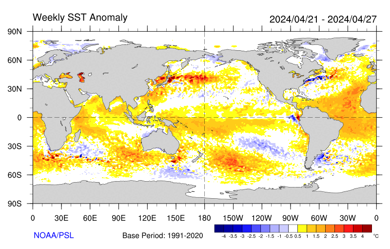
Sea-surface temperature satellite data from the National Oceanic and Atmospheric Administration mirror Jason sea-surface height measurements, clearly showing a cool Pacific Decadal Oscillation pattern, as seen at: http://www.cdc.noaa.gov/map/images/sst/sst.anom.gif.

"This multi-year Pacific Decadal Oscillation 'cool' trend can cause La Niña-like impacts around the Pacific basin," said Bill Patzert, an oceanographer and climatologist at NASA's Jet Propulsion Laboratory, Pasadena, Calif. “The present cool phase of the Pacific Decadal Oscillation will have significant implications for shifts in marine ecosystems, and for land temperature and rainfall patterns around the Pacific basin.”

According to Nathan Mantua of the Climate Impacts Group at the University of Washington, Seattle, whose research contributed to the early understanding of the Pacific Decadal Oscillation, "Even with the strong La Niña event fading in the tropics last spring, the North Pacific's sea surface temperature anomaly pattern has remained strongly negative since last fall. This cool phase will likely persist this winter and, perhaps, beyond. Historically, this situation has been associated with favorable ocean conditions for the return of U.S. west coast Coho and Chinook salmon, but it translates to low odds for abundant winter/spring precipitation in the southwest (including Southern California)."

Jason's follow-on mission, the Ocean Surface Topography Mission/Jason-2, was successfully launched this past June and will extend to two decades the continuous data record of sea surface heights begun by Topex/Poseidon in 1992. The new mission has produced excellent data, which have recently been certified for operational use. Fully calibrated and validated data for science use will be released next spring.

JPL manages the U.S. portion of the Jason-1 mission for NASA's Science Mission Directorate, Washington. JPL is managed for NASA by the California Institute of Technology in Pasadena.

For more information on NASA's ocean surface topography missions, visit http://sealevel.jpl.nasa.gov/ . To view the latest Jason-1 data, visit http://sealevel.jpl.nasa.gov/science/jason1-quick-look/ .

WEATHER NOTE

Wave surge hits PNG


A huge wave has hit a Papua New Guinea island, submerging buildings and causing widespread damage but no casualties.

The giant wave hit Kavieng, on the New Ireland province, late on Tuesday and there were reports of a similar surge hitting PNG’s north-eastern coast province of East Sepik.

Details remain sketchy but one witness told AAP the water surge hit late this afternoon and disaster teams are now working through the damage.

“The wave took out the hospital and the east coast road of New Island,” local resident Nessie Amos said.

“The hospital’s equipment was washed out but patients were saved and taken to another hospital,” she said.

“There were no casualties but major damage was caused to the hospital and everything was washed out.”

Amos said one small island off Kavieng, Tents, is mostly under water and villagers have been moved to the neighbouring island of Emirau.

Government officials held a press conference in Wewak earlier this evening.

MARITIME NOTE

Report on Collision Death off Pt. Reyes

On Dec. 10, the U.S. Coast Guard released the results of two investigations. One report outlines the causes of the July 13, 2007 fatal collision between a cargo ship and a small fishing boat which occurred in heavy fog off Pt. Reyes, and the other is an internal review of the service's handling of the incident.

The incident involved the 291 ft motor vessel Eva Danielsen, a Bahamian-flagged cargo ship, and a 28 ft wooden fishing vessel, the Buona Madre, home ported in Santa Cruz, California. A collision between the two vessels resulted in the destruction of the fishing boat and the death of Mr. Paul Wade.

A Coast Guard Marine Casualty Investigation, which was conducted by San Francisco-based investigators and reviewed and released from Coast Guard headquarters in Washington D.C., found numerous factors contributing to the cause of the collision including: failure to ensure proper manning of the respective vessels in light of the prevailing weather conditions (heavy fog); and the freighter proceeding at an unsafe speed based upon the weather conditions, failing to follow applicable Navigational Rules of the Road (i.e., fog signals), and negligence with respect to the operation of the vessel.

An internal administrative investigation was also conducted by the 11th Coast Guard District to evaluate how Coast Guard policies and procedures were followed. The internal investigation found that some internal briefing requirements and communications processes were not followed. Several recommendations of the report have been adopted to improve management of communications among Coast Guard units including: Revision of Command Center Standard Operating Procedures to include recent CG policy changes; review and revision of all Quick Response Sheets (QRS) to ensure proper notifications are made in a timely fashion; Introduction of Search and Rescue fundamentals in the Coast Guard Vessel Traffic Service (VTS) training program; and cross training among various watch positions in the Coast Guard Sector Command Center and VTS.


RS

Monday, December 29, 2008

Sub to make deep Caribbean dive

Sub to make deep Caribbean dive

Scientists are set to explore the world's deepest undersea volcanoes, which lie 6km down in the Caribbean.

Delving into uncharted waters to hunt for volcanic vents will be Autosub6000, Britain's new autonomously controlled, robot submarine.

Once found, the life, gas and sediment around the vents - the world's hottest - will be sampled and catalogued.

The research will be carried out by a British team aboard the UK's latest research ship, the James Cook.

"We are heading out on two expeditions, each close to a month long, to map the full length of the Cayman Trough," said team leader, Dr Jon Copley of the National Oceanography Centre in Southampton (NOCS).

Dr Copley explained that the Cayman Trough, which lies between Jamaica and the Cayman Islands, is a product of the Caribbean tectonic plate pulling away from the American plate.

"It is the world's deepest volcanic ridge and totally unexplored," the Southampton-based researcher told BBC News.

Along with Autosub6000, the researchers will also rely on Isis, the UK's deepest-diving, remotely operated vehicle to scan the deep.

Double Sub

First overboard will be Autosub6000, an unmanned undersea vehicle that can go down to 6,000m and carry out a dive without being controlled from the surface.

It will be tasked with finding the volcanic vents on the ocean floor.

The second submarine to take the plunge will be the Isis.

Isis will sample fluids and sediments from around the lip of the vents to test their geochemistry, and also collect animal specimens.

Map
Britain's new robot sub will map the entire length of the Cayman Trough

"We are hoping to find several different types of vents along the ridge," said Dr Copley.

"Some of the vents will be very similar in depth to the vents we already know about, and because the conditions will be alike, we might expect very similar animals," he explained.

The researchers will look to compare the animals around the Cayman vents with those in the Atlantic and Pacific, in the hope of better understanding the processes that affect how deep-sea creatures "get about".

If the organisms in the Cayman Trough look like those from other deep volcanic trenches, it will suggest that ocean currents must play a role in shaping the patterns of deep-sea life by transporting the animals' larvae around.

However, if the Cayman Trough animals are very different from those existing in other parts of the Earth's oceans then isolation will be considered more important.

"The deep ocean is our planet's largest ecosystem. If we are going to use its resources responsibly then we need understand what determines its patterns of life," the Southampton-based researcher said.

New vents

Dr Copley told BBC News that there was also another kind of venting that was driven by a very different geological process in which the Earth's mantle is directly exposed to the water.

Arm/NOCS
The researchers will explore vents looking for deep-sea animals

This type of volcanism has only ever been seen once before, in the mid-Atlantic.

The temperatures around these hydrothermal vents were so hot because they were so deep, Dr Copley said.

"They could be hotter than 500C (930F), and if they are that hot, they will probably have quite different chemistry and life forms - we expect to find new species."

The researchers expect that, at depths greater than 3,000m, one in every two animals they come across will be a species new to science.

WEATHER NOTE

Ocean observations reap climate science rewards
Long-term observations of the oceans around Australia are providing the nation’s climate scientists with significant benchmarks for seasonal forecasts and monitoring future climate change.
15 December 2008

Initiated near the end of a two-year El Niño event in May 1983, the program involves the deployment of simple ‘expendable instruments’ (XBTs) from commercial shipping that measure temperature and currents to a depth of 800m along routes in the Indian, Pacific and Southern Oceans.

“There is so much ocean around Australia influencing our daily weather and longer term climate that it made sense to begin a record from which we could connect ocean change to shifts in rainfall patterns across southern Australia,” says Dr Gary Meyers who, with colleagues at CSIRO, the Bureau of Meteorology (BoM) and the Scripps Institute of Oceanography in the US, established the ocean monitoring system.

“The 1982/83 El Niño came as a big surprise when we saw all kinds of changes around Australia but didn’t understand them. Now these ocean temperature data contribute to the BoM’s routine seasonal climate forecast.”

At 25 years the system stands as one of the longest sustained ocean observing networks in the world, and is a rare long-term record of ocean change in the huge and poorly monitored Southern Hemisphere ocean domain.

Based on the records, CSIRO’s Dr Susan Wijffels and co-authors will publish a landmark paper on the mean currents flowing between Australia and Indonesia in the Journal of Physical Oceanography. These currents form a critical ocean interconnection – the so-called Indonesian Throughflow – in the distribution of heat in the global climate system.

“Today, we have over 60,000 measurements of temperature around Australia that scientists regularly use to assess past long-term trends – test models used to predict future climate or forecast ocean behaviour,” says Dr Meyers, who leads Australia’s Integrated Marine Observing System (IMOS). “More than 50 scientific publications and books have been published using the Australian data.”

MARITIME NOTE

USCG – Marine Safety Performance

The US Coast Guard released its Marine Safety Performance Plan for FY 2009-2014.

The plan addresses the goals of: (1) reducing the risk of marine casualties; (2) facilitating commerce; (3) improving program processes and management; and (4) improving human resource capabilities. The Marine Safety Program pursues these goals through a multi-faceted approach that includes standards development; mariner credentialing; compliance enforcement; investigations and casualty analysis; industry and public outreach; and international engagement.

The Plan is a living document and may be changed in the future to reflect the results of a currently-ongoing independent evaluation of the Marine Safety mission, scheduled for completion in March 2009. Comments on the Plan are also solicited from the regulated community and other stakeholders.

(Source: Holland & Knight)


Thursday, November 27, 2008

Astonishing Life In Ocean's Depths: Major Progress Made Towards Historic Census Of Marine Life

Astonishing Life In Ocean's Depths: Major Progress Made Towards Historic Census Of Marine Life

ScienceDaily (Nov. 10, 2008) — The 2,000-strong community of Census of Marine Life scientists from 82 nations has announced astonishing examples of recent new finds from the world’s ocean depths. Mollusk expert Patricia Miloslavich (Venezuela), Census co-senior scientist: “We are beginning to pull together a picture and clarify the complicated and interconnected global drivers of marine biodiversity patterns and changes, and we are starting to see the conservation-related implications and benefits, from the small coves of the near-shore to the vast abyss.”

Antarctic ancestry of many deep-sea octopuses worldwide

Within their mandate "to assess and explain the diversity, distribution, and abundance of marine life in the oceans – past, present, and future,” Census of Antarctic Marine Life scientists report the first molecular evidence that a large proportion of deep sea octopus species worldwide evolved from common ancestor species that still exist in the Southern Ocean.

Octopuses started migrating to new ocean basins more than 30 million years ago when, as Antarctica cooled and a large icesheet grew, nature created a “thermohaline expressway,” a northbound flow of tasty frigid water with high salt and oxygen content.

Isolated in new habitat conditions, many different species evolved; some octopuses, for example, losing their defensive ink sacs – pointless at perpetually dark depths.

This revelation into the global distribution and diversity of deep sea fauna, to be reported Nov. 11 in the journal Cladistics, was made possible by intensive sampling during Census International Polar Year expeditions.

Other findings are listed below.

Distribution of sea life

Scientists discover both a “White Shark Café” and a “sturgeon playground” in the Pacific, as others explore life on a “new continent” in the mid-Atlantic, in oceanic canyons, around Earth’s deepest hot vents, and in the world’s coldest, saltiest seawater;

Deep sea diversity

Deep sea explorers discover new forms of life, including behemoth bacteria, colossal sea stars, astonishing Antarctic amphipods and a mammoth mollusk, and find familiar species in many new places. Experts also estimate that, beyond the 16,000 marine fish species already known to science, another 4,000 await discovery, many of them in the tropics.

Abundance

Researchers find a sea floor carpet of bugs and a city of brittle stars, and document bluefin tuna abundance in the early 1900s by scouring fishery reports, fishing magazines and other records.

Meanwhile, the Ocean Biogeographic Information System has grown to include more than 120,000 species. And a rapidly-expanding reference library of DNA barcodes of marine species recently helped reveal inaccurate labeling of sushi in New York City and elsewhere.

As well, the national and regional networks expediting much of the Census work expanded from 10 to 12 since 2006. They and the field projects of the Census established precedent-setting ethical standards for marine research.

As more than 700 delegates gather for the World Conference on Marine Biodiversity (Valencia, Spain Nov. 11-15), organized by the Census’s European affiliate program on Marine Biodiversity and Ecosystem Functioning, the report details major progress towards the first ever marine life census, for release in October, 2010.

Other research highlights

1) Exploring a “new continent” in mid-Atlantic: MAR-ECO (http://www.coml.org/descrip/mareco.htm) scientists describe their work as “surveying a new continent half way between America and Europe.” Sampling along the Mid-Atlantic Ridge at depths down to 2,500 meters, they find many hundreds of species rare or unknown elsewhere in the world and collect environmental data to help explain their distribution and abundance.

2) World’s deepest known active hot vent: ChEss (http://www.coml.org/descrip/chess.htm) scientists in the Mid-Atlantic Ridge explore the world’s deepest known active hot vent, field named Ashadze, over 4,100 meters deep, dominated by anemones, polychaete worms and shrimp. They also discover marine environments with little or no oxygen harboring more life than expected.

3) Bacterial mats in Black Sea: ChEss scientists also find reefs deep in the Black Sea made of bacterial mats using methane (natural gas) as an energy source, the bacteria forming spectacular chimneys up to four meters high. Such reefs could contribute key insights into mechanisms controlling emissions of methane, an important greenhouse gas, from the ocean to the atmosphere.

4) Brittle Star City: Exploring off the coast of New Zealand, CenSeam (http://www.coml.org/descrip/censeam.htm) researchers capture images of a novel “Brittle Star City,” whose inhabitants colonize the peak of a seamount – an underwater summit taller than the world’s tallest building. In a swirling circumpolar current flowing at roughly four kilometers per hour, tens of millions of brittle stars live arm tip to arm tip. The current kept away would-be predators while delivering an ample supply of food that residents of Brittle Star City collected simply by raising their arms.

5) Surprisingly different twins: NaGISA (http://www.coml.org/descrip/nagisa.htm) nearshore scientists in the Alaskan Arctic find a site with a rocky seafloor, rare along the normally soft and silty Arctic coastline. The hard substrate hosts a highly diverse community compared to surrounding soft bottom habitat. Comparison of this new site to a similar site surveyed by Census researchers in 2002 shows surprisingly different communities. Census nearshore scientists collaborating with local agencies also discover new species in the Aleutian archipelago, including a kelp, sea anemones, chitons, snails, and sea stars.

6) Pacific hotspots: TOPP (http://www.coml.org/descrip/topp.htm) researchers discover eddies of warm water in the Pacific may meld, forming hotspots in the open sea that support elevated levels of tiny phytoplankton that form the base of the marine food web. These green meadows in the vast Pacific in turn concentrate species from all tiers of the food web – from shrimp to large predators like tuna, seabirds, and whales.

7) Seep mega-sites: COMARGE (http://www.coml.org/descrip/c-margins.htm) and ChEss scientists discover more lively communities flourishing off cold gases such as methane seeping out of the sea floor. Around New Zealand, they map the “Builder’s Pencil” site covering about 180,000 square meters, among Earth’s largest known seep sites. Sensitive to human activities despite their depth, the communities keep revealing unique features. Finding both potential new species and scars from deep-water trawls by fishing vessels on the scientific surveys suggests the urgency for further conservation of these fragile habitats.

8) Philippine firsts: In the first deep-sea work in the area, COMARGE researchers sample to a depth of 2,300 meters, collecting about 300 fish and 400 mollusc species for barcoding. Some 320 decapod crustaceans are photographed, displaying their beauty and aiding future identification of many unique and subtly distinct specimens.

In 2008, COMARGE investigators return to explore the Philippine margin of the South China Sea, between 100 and 2,200 meters depth. Discoveries include the first Philippine record of the deep-water stony coral Lophelia pertusa, the first living specimen of Acharax bartschi (a large bivalve living in symbiosis with bacteria), rare deep-water snails living on a dog’s skull that had washed out to sea, and a likely new species of shrimp belonging to a group only known from hydrothermal vents. The trawl also collected many plastic shopping bags.

9) Potential new marine protected area, Africa: While largely unexplored, the rich Western Indian Ocean, including the Mozambique channel, suffers destructive fishing practices, such as use of dynamite. Census-affiliated explorers with the Sub-Sahara African Committee chart a proposed marine protected area off Tanga, Tanzania. Using SCUBA and remotely operated vehicles, Tanzanian scientists and students join international researchers to survey life along transects that could be periodically revisited, collecting samples for identification and barcoding.

10) Life in coldest, saltiest seawater: ArcOD (http://www.coml.org/descrip/aobio.htm) researchers studying life in the Arctic find temperatures of –25°C in sea ice channels where brine is more than six times saltier than regular sea water. Representing the coldest conditions in the global ocean, researchers find sea ice algae, such as diatoms, and flagellates thriving in concentrations of thousands of individuals per liter.

11) 100 new species and records near Hawaii: CReefs (http://www.coml.org/descrip/c-reefs.htm) experts census biodiversity in the French Frigate Shoals, the world’s largest, fully protected marine area in the Northwestern Hawaiian Islands. Using a variety of new and proven methods over a diverse range of habitats, the team logs more than 100 species and new records.

12) Carpet of bugs: COMARGE researchers describe a new species of amphipod, Ampelisca mississippiana, inhabiting the head of the Mississippi Canyon about 460 meters deep in the Gulf of Mexico. These small crustaceans (less than 6 millimeters in length) and living in tubes, carpet the seabed in densities up to 12,000 individuals per square meter. Based on its abundance and the stabilizing effects this “carpet of bugs” has on sediments, researchers believe this amphipod may have great ecological importance.

13) Deepest comb jelly: CMarZ (http://www.coml.org/descrip/cmarz.htm) explorers find a potential new species of comb jelly, or ctenophore, at the record depth of 7,217meters in the Ryukyu Trench near Japan – the deepest ever recorded siting of this unique species, that flies like a kite on the end of two long “strings” attached to the bottom. The discovery raises questions about the availability of food resources at such depths, which had not been thought capable of supporting predators like this one.

14) Evolutionary mollusk: In the Southern Ocean, CAML (http://www.coml.org/descrip/caml.htm) researchers find many potential new species including sea cucumbers, sponges and komokiaceans – little known protozoa living in the depths of the ocean resemble the organisms that form chalk. They also collect a rare mollusk, named Laevipilina antarctica, believed to play a role in how segmentation evolved in marine invertebrates.

15) Arctic jellies galore: In the Canada Basin of the Arctic Ocean, ArcOD researchers find several new species and more than 50 taxonomic categories of gelatinous zooplankton. Almost two-thirds are medusae, one-fifth siphonophores, and one-tenth larvaceans. The first new species formally described from the expedition was named Sigambra healyae, in honor of the research vessel, the U.S. Coast Guard Cutter Healy.

16) 85 new zooplankton species: CMarZ scientists discover at least 85 new species of zooplankton, small drifting and swimming marine animals. Four genera and one family were officially deemed new to science, with many more expected to follow. In the Atlantic Ocean from Germany to South Africa, scientists collect zooplankton in a range from the surface to below 5,000 meters. Taxonomic experts and geneticists identify and barcode the DNA from hundreds of species. As expected, several new species of small crustaceans called ostracods or seed shrimp and other groups are found.

17) Antarctica’s big amphipod: CAML scientists exploring a 10,000 kilometer portion of the Antarctic Weddell Sea made suddenly accessible by the collapse of the Larsen A and B ice shelves sample an estimated 1,000 species. Of these, four presumed new species of cnidarians (organisms related to coral, jelly fish and sea anemones) are found, as well as 15 potentially new amphipod (shrimp-like) species, including one of Antarctica’s biggest-ever amphipod crustaceans, nearly 10 centimeters long.

18) Spectacular species in Celebes Sea: Zooplankton researchers with CMarZ travel to a biodiversity hot spot in the Celebes Sea in the southern Philippines, uncovering unexpected richness and diversity of marine life from the surface to the almost totally unexplored deep waters. Divers collect a remarkable variety of fragile and beautiful gelatinous species, while video cameras and collect images and organisms from depths beyond the divers' reach.

19) Surprising species richness: Recent advances in technology are opening up remote frontiers – deep-sea canyons. COMARGE researchers aboard the RRS James Cook off Portugal find that species richness was almost double in the more active Nazaré Canyon than in Lisbon Canyon. This is despite Lisbon Canyon receiving a substantial supply of river-borne organic matter that would foster large populations of filter-feeding organisms.

20) 11,130 known species in South African waters: Experts with the Census’ Sub-Sahara African Committee estimate 6,000 more species, primarily smaller marine animals, are yet to be discovered in South African waters, which are already known to feature some 11,130 species. A new shrimp (Hippolyte) and the first record of the enigmatic group Myzostomida from the region are discovered in False Bay, the most sampled site on the African coast.

21) 870+ squat lobster species: COMARGE scientists list 870 known species of squat lobsters and create an electronic library of relevant literature. Squat lobsters are colorful decapod crustaceans found in all oceans, at all depths, and in all marine habitats, but are especially abundant on continental margins.

22) Antarctic expressway: In the Southern Ocean, Census CAML explorers find evidence that deep sea octopuses ride the “Antarctic thermohaline expressway.” The northbound expressway is a mass of sea water with a high salt density caused by the ice that forms at the surface around the Antarctic, the water cascading like cream.

They find as well that sea birds feed on Antarctic zooplankton when the tiny organisms aggregate at a thermal front.

23) Animals in new places: ArcOD explorers make the first record of many marine animals in many areas of the Canada Basin. These include abundant and diverse ctenophore (comb jellies) under Arctic pack ice and a dense bed of sea cucumbers in what might be a pockmark. They also record more squid than ever before in the Arctic deep sea, and document the importance of sea ice ridges for marine life in the region.

24) White Shark Café: Satellite tagging by TOPP reveals a previously unknown behavior of white sharks (http://www.eol.org/taxa/17143484), travelling long distances each winter to concentrate in the Pacific for up to six months. During these months, both males and females make frequent, repetitive dives to depths of 300 meters, which researchers theorize may be significant in either feeding or reproduction.

25) Migration pathway: MAR-ECO researchers suggest the Mid-Atlantic Ridge may serve as an important pathway in colonization of North Atlantic continental slopes. Before their expeditions, scientists thought skates and rays, for example, migrated through the Mid-Atlantic Ridge, rather than taking up residence there.

26) New species in familiar waters: Systematically exploring two islands on the Great Barrier Reef and a reef off northwestern Australia, CReefs researchers find hundreds of new kinds of animals in waters were long familiar to divers. They also conduct the first scientific inventory of spectacular soft corals, named octocorals for the eight tentacles that fringe each polyp.

27) Australian expedition: One species in three new to science: The first results from the COMARGE “Voyages of Discovery” expeditions to the deep continental shelf and slope in Australia’s southwest region show 524 species of Decapoda—crabs, shrimps, prawns, lobsters, and the like. Some 33 percent of all species encountered are suspected to be new species, and 25 percent are new records in the region, eight percent are new records for Australia.

28) Sponge garden: COMARGE and ChEss researchers examining cold seeps in the Mediterranean Sea using remotely operated vehicles find surprisingly abundant marine life, including a garden of sponges around a brine lake. The sponge itself, likely Rhizaxinella pyrifera, harbours a multitude of small worms.

29) Behemoth bacteria: A diverse set of giant, filamentous, multi-cellular marine bacteria is discovered by ICOMM (http://www.coml.org/descrip/icomm.htm) researchers in the eastern South Pacific. These bacteria may be “living fossils” that developed in the earliest ocean when oxygen was either absent or much diminished, living on the toxic gas hydrogen sulfide. Scientists hypothesize that communities of bacteria may hold potential for bioremediation of organically polluted bottoms and, because of their ability to survive in anoxic conditions, may be an important clue in the search for extraterrestrial life.

30) Colossal sea stars: CAML expeditions to the Southern Ocean find frequent examples of gigantism common in Antarctic waters. The researchers collect huge scaly worms, giant crustaceans, starfish and sea spiders as big as dinner plates.

31) Largest mollusk in class: A giant aplacophoran mollusk, Chaetoderma felderi, is collected in deep waters off Louisiana by GoMex, a Census-affiliated project working in the Gulf of Mexico. Measuring over 407 mm in length and 10 mm in diameter, about the size of a AAA battery, it is more than twice the length and three times the diameter of the next largest known mollusk in the subclass.

32) Gigantic oysters: With the assistance of a remotely operated vehicle, COMARGE explorers find dense communities of giant oysters 20 cm (eight inches) long at a depth of 700 m on the La Chapelle continental slope. Genetic studies will confirm if this is a new species.

33) Barcoding zooplankton: An international CMarZ team from 25 cooperating projects is analyzing data from roughly 6,000 historical samples to help create a catalog of described species diversity and distribution. DNA barcodes will identify approximately 7,000 known species of zooplankton in 15 phyla. This growing database will help scientists identify specimens, describe their geographic distributions, and recognize when a species is in fact new. Scientists envision a day soon when quick, automated sample barcoding analysis will be a reality.

34) Following fishers to find vents: Stymied in their search for active methane seeps in the Chilean margin, COMARGE scientists take a novel approach: follow the fishers. They launch their search in known fishing grounds of the Patagonian toothfish (Dissostichus eleginoides), suspecting that these fish congregate near methane seeps. Their hunch proves correct: Most fishing grounds were associated with hard grounds, with some made of carbonates associated with methane seepages.

35) Coral reef colonization: To learn what new creatures colonize coral reefs, CReefs scientists develop and test Autonomous Reef Monitoring Structures (ARMS), to be colonized by fish and other creatures that inhabit coral reefs. The structures mimic the “nooks and crannies” of a natural reef. With this information, marine scientists can better understand the health of reefs and policy makers can develop scientifically-based management strategies.

36) Mapping microbes: To identify marine microbes and survey their distribution around the globe, ICoMM launches 40 separate projects using the same DNA sequencing technology, “454 tag-pyrosequencing.” The efficient identification by a standardized method allows scientists to inventory areas as diverse as polar biodiversity hotspots, coastal microbial mats, and sediments in tropical coral reefs. They can then create unprecedented global maps of the tiniest life in the ocean.

37) Arctic robots: Two new underwater robots give ChEss scientists a bird’s eye view of what lives on Gakkel Ridge in the Arctic Ocean. These exploration vehicles carry cameras and sophisticated arrays of instruments used by scientists to discover a new underwater volcanic chain covered by extensive microbial mats. Because the deep Arctic ridges are isolated from other ocean basins, the investigation of Gakkel Ridge provides clues about the evolution of fauna around underwater vents in isolated habitats.

38) Nearshore research expands worldwide: NaGISA expands nearshore research within the Caribbean, South America, and around the Indian Ocean through regional workshops aimed at standardizing protocols. Scientists use these protocols in monitoring and educational program to assess environmental impacts and to engage local communities in the process.

39) A highly detailed look at biodiversity in a well-documented bay: A unique collaboration of U.S. and Canadian GoMA (http://www.coml.org/descrip/gom.htm) researchers enhances knowledge of changing marine eco-systems by studying the nearshore zone of Cobscook Bay, Maine, from both historical and present-day perspectives. One of the most diverse coastal ecosystem on the North American east coast north of the tropics, this estuary features many different habitats, a tidal range of over eight  meters, two centuries of historical records dating back to 1842, and more than 800 species identified to date.

40) Engaging the public: NaGISA scientists studying the nearshore environment of the world ocean are present on six continents. Science education programs and training workshops aim to incorporate research protocols, which makes data gathered in the coastal environment comparable from place to place. The nearshore investigations engage the public in ocean and coastal issues and inspire the next generation of marine scientists.

41) International study of plankton bloom: In the Southern Ocean, collaborating CeDAMar (http://www.coml.org/descrip/cedamar.htm) researchers follow a plankton bloom from its onset until it changes to marine snow and finally sinks to the deep-sea floor. The scientists then examine the influence of the snow of fallen plankton on marine life on the floor itself. It is the first such collaboration undertaken since the Galathea expedition in the early 1950’s. In spite of bad weather and complicated logistics, the collaboration produces a trove of data.

42) Leading research for International Polar Year: Census projects play a key role in the International Polar Year 2007-2009. In the Arctic, the Census leads the marine biodiversity cluster of 13 projects from eight countries on more than 20 expeditions. They observe how mammals use diverse polar habitats, inventory life in a fjord, and explore seeps, pockmarks, and mud volcanoes on remote ocean floors. In the Southern Ocean, the Census coordinates the science on 10 major expeditions by vessels from nine different countries, the results reported live via the Internet. The Census also initiates a collaborative program focusing on Antarctic marine life in seven South American countries.

43) Race to protect sea turtles: The Great Turtle Race, an international race developed by TOPP to save a 100-million-year-old species from extinction moved to China in 2008. A Mandarin language version of an interactive webpage tracks the migration of endangered leatherback turtles, bringing the race to approximately 100 million Chinese citizens. Donations go to protection of leatherback turtle nesting areas in Indonesia, and raise awareness of the turtles plight.

44) Leatherback conservation: For more than 12,095 satellite-tracking days over three years, TOPP scientists track leatherback turtles and compile the largest, multi-year migration record ever. The data reveals that ocean currents shaped the migration corridor and turtle dispersal in the South Pacific.

45) Hydrothermal vents and seabed mining: ChEss scientists orchestrate a joint scientific and policy meeting for the spring of 2009 to discuss protection of the vent sites from the potential growth of deep sea mining. The meeting’s goal: set priorities for future research and balance the conservation of critical vent sites versus the value of ores.

46) Focusing fishery management: MAR-ECO research along the Mid-Atlantic Ridge strives to fill information gaps about the distribution and abundance of certain species of grenadier (http://www.eol.org/taxa/17063155), distant relatives of codfish in the North Atlantic. Amid the uncertainty, regional managers take precautionary measures to protect grenadier stocks and their habitats.

47) CSI in the sea: DNA barcoding shark fins: Demand for their fins and other organs impact global shark populations. The frequently inaccurate identification of sharks and rays confuses what fishermen are catching, what fins and organs markets are selling, and how populations are changing. Accordingly, researchers with the Marine Barcode of Life project (http://www.marinebarcoding.org/publications) develop DNA barcoding to identify species of sharks and their products, such as dried fins, essential to knowing how many sharks are being caught and to enforce prohibitions. (See also http://phe.rockefeller.edu/docs/pacificfishingsept2008.pdf)

48) Managing underwater mountains: CenSeam expeditions in the Southern Ocean and Antarctica expand knowledge of life on seamounts, providing a foundation for sustainable management of these ecosystems. Census researchers deliver a report to the United Nations General Assembly on the vulnerability of seamount corals to fishing and help develop guidelines for deep-sea fisheries.

49) Learning from the past: Rise and fall of tuna: Scouring fishery reports, fishing magazines, and other records, HMAP (http://www.coml.org/descrip/hmap.htm) researchers document the presence of bluefin tuna (http://www.eol.org/taxa/17050078) in northern European waters several decades before the onset of major fisheries in the early 1900s. After fishing increased and techniques became more powerful, the fishery collapsed in the mid-1960s. Documentation of the historical abundance of this especially popular seafood species, and its subsequent collapse, will be used to inform future decisions.

50) Assessing human impact: HMAP brings together a worldwide network of experts from multiple disciplines to figure out why populations of mollusc have declined. They report their work in a book, Early Human Impact on Megamolluscs (Oxford: Archaeopress).

51) High mortality for young salmon: Using acoustic tagging, POST (http://www.coml.org/descrip/post.htm) researchers track the progress of young Chinook salmon (http://www.eol.org/taxa/17154704) as they move from freshwater rivers in the Canadian and US northwest out to the ocean and eventually to the Alaska coast. The observations suggest that in just a few weeks, 40 percent of the tracked salmon perished in the ocean.

52) Sturgeon playground: POST researchers discover green sturgeon congregate at a “playground” off Vancouver Island before moving on to Alaska for the winter, contrary to scientists’ expectations. The reason for their layover is unknown, but it makes them susceptible to potential over-exploitation.

53) Conserving life in open ocean: MAR-ECO documentation of the quantity and patterns of diversity on the mid-Atlantic Ridge summit at 3,500 meters helps international management organizations protect habitats and assure sustainable resource use. Continued work by Census scientists and a variety of partners creates a better basis for conservation of marine life in the immense areas of the oceans that lie beyond national jurisdiction.

54) Tuna and Billfish distribution: FMAP (http://www.coml.org/descrip/fmap.htm) researchers investigate the global distribution patterns of two highly migratory predators, tuna and billfish, and relate the information to the temperature tolerances of these species, work that may help anticipate the effects of ocean warming on biodiversity.

55) OBIS reaches 16 million records: Census experts creating the Ocean Biogeographic Information System (http://www.coml.org/descrip/obis.htm), log 16 million biological records, with 17 million expected by year’s end, received from nodes around the world. Collaboration with the Encyclopedia of Life, among others, expedites information sharing, creating an integrated system containing geographical, biographical, evolutionary, and genetic information, as well as images.

56) Counting all creatures in the Gulf: Scientists complete a comprehensive inventory of all marine life in the Gulf of Mexico. Published in a 79-chapter book written by 140 authors from 15 countries, the inventory shows 15,625 species from 40 different phyla in the Gulf. A second phase of the project currently underway will make the information available in a searchable online database.

57) Listing all species, eliminating aliases: The list of known marine species surpasses 120,000, placing the Census halfway toward its goal of cataloging the estimated 230,000 known species by 2010. The Census-affiliated World Register of Marine Species (WoRMS) identifies more than 56,000 aliases for ocean species, with one species, the “breadcrumb sponge,” alone having 56 scientific names.

58) 4,000 Marine Fish May Await Discovery: Employing a novel approach to count quantify global fish species, FMAP researchers estimate that almost 16,000 species of marine fish are recorded in publicly accessible databases. They suggest another 4,000 fish species await discovery and description, many of them in the tropics.

Happy Thanksgiving from all of us at Robin Sorm to all of you!


RS

Wednesday, July 30, 2008

Dust Storms In Sahara Desert Sustain Life In Atlantic Ocean

Dust Storms In Sahara Desert Sustain Life In Atlantic Ocean

ScienceDaily (July 19, 2008)
— Research at the University of Liverpool has found how Saharan dust storms help sustain life over extensive regions of the North Atlantic Ocean.

Working aboard research vessels in the Atlantic, scientists mapped the distribution of nutrients including phosphorous and nitrogen and investigated how organisms such as phytoplankton are sustained in areas with low nutrient levels.

They found that plants are able to grow in these regions because they are able to take advantage of iron minerals in Saharan dust storms. This allows them to use organic or ‘recycled’ material from dead or decaying plants when nutrients such as phosphorous – an essential component of DNA – in the ocean are low.

Professor George Wolff, from the University’s Department of Earth and Ocean Sciences, explains: “We found that cyanobacteria – a type of ancient phytoplankton – are significant to the understanding of how ocean deserts can support plant growth. Cyanobacteria need nitrogen, phosphorous and iron in order to grow. They get nitrogen from the atmosphere, but phosphorous is a highly reactive chemical that is scarce in sea water and is not found in the Earth’s atmosphere. Iron is present only in tiny amounts in sea water, even though it is one of the most abundant elements on earth.

“Our findings suggest that Saharan dust storms are largely responsible for the significant difference between the numbers of cyanobacteria in the North and South Atlantic. The dust fertilises the North Atlantic and allows phytoplankton to use organic phosphorous, but it doesn’t reach the southern regions and so without enough iron, phytoplankton are unable to use the organic material and don’t grow as successfully.”

Professor Ric Williams, co-author of the research, added: “The Atlantic is often referred to as an ‘ocean desert’ because many nutrients, which are essential in plant life cycles, are either scarce or are only accessible in the darker depths of the ocean. Plants, however, need some sunlight in order to absorb these important nutrients and so can’t always access them from the ocean depths. They therefore need to find the nutrients from elsewhere. Now that we are able to show how cyanobacteria make use of organic material we can understand more clearly how life is sustained in the ocean and why it isn’t an ‘ocean desert.’

“These findings are important because plant life cycles are essential in maintaining the balance of gases in our atmosphere. In looking at how plants survive in this area, we have shown how the Atlantic is able to draw down carbon dioxide from the atmosphere through the growth of photosynthesising plants.”

The research is published in Nature GeoScience.

The study also involved scientists at the National Oceanographic Centre, Southampton and the Plymouth Marine Laboratory. The work was funded by the UK Natural Environment Research Council.

WEATHER NOTE

Powerful dust devil suspected in death

Associated Press - June 21, 2008 3:45 PM ET

CASPER, Wyo. (AP) - Meteorologists in Casper believe a strong dust devil is probably what blew over a 1,000-pound shed and killed a South Dakota woman this past week.

A micro burst was initially suspected in the accident that killed Jennifer Job-Massa, of Sioux Falls, S.D.

But National Weather Service meteorologist Chris Jones says a micro burst is usually a mile or more across and would most likely have caused other damage in the area.

Jones says a dust devil, or whirlwind, can have the similar effect of a tornado on a much smaller scale.

Authorities believe the 60-to 80-mph winds in the dust devil toppled the shed Wednesday as Job-Massa likely sought shelter behind it.

Waterspout Forms Off Deerfield Beach

DEERFIELD BEACH (CBS4) ― Beachgoers on Deerfield Beach had quite a sight Tuesday morning when a waterspout formed just offshore.

The short-lived waterspout was spotted around 10:00 a.m. It lingered there for a few minutes and didn't move much before it dissipated.

A few showers or storms could make it onshore throughout the morning and early afternoon hours, but no severe weather is anticipated.

Waterspouts can easily overturn boats and create locally hazardous seas. According to the National Weather Service, the best course of evasive action if threatened by a waterspout is to move at a 90 degree angle from its apparent movement. Seek safe harbor immediately.

(© MMVIII, CBS Broadcasting Inc. All Rights Reserved.)

MARITIME NOTE

Though the Compact is signed, Great Lakes are still at risk

THE Great Lakes Compact took 10 years to write and pass, generated a thousand adoring news releases, and now goes off to Washington for what the region hopes is quick approval by Congress. Great work, right? Not so fast - let's look past the self-congratulatory press releases.
Advertised as a guarantee of "a future in which the Great Lakes are forever sustained" (Gov. Ted Strickland of Ohio), "a strong regional warning to chronically dry regions of the South and West" (Chicago Tribune), and "something that will protect the Great Lakes for generations to come" (Wisconsin state Sen. Scott Gunderson), it's actually a way for bottled-water companies to gain rights to sell Great Lakes water.

What's the problem? Doesn't this pact set standards to limit or deny major Great Lakes diversions? Yes, for the most part through a pipe, but not in small containers. Also not addressed is the connection between groundwater and the Great Lakes. Groundwater is tied to the Great Lakes, supplying much of their flow.

To understand the biggest problem, it's important to remember how the whole thing got started 10 years ago.

In May, 1998, it suddenly became known through media reports that the Ontario Ministry of Natural Resources granted a permit to a private firm, the Nova Group, that wanted to ship up to 50 tanker vessels of Lake Superior water each year to unidentified private customers in Asia.
Turning Great Lakes water into a product - especially the water of Lake Superior, the purest and coldest of the Lakes - fueled indignation among citizens on both sides of the international border. Chastened after public hearings and media scoldings, the Nova Group gave up its permit, and Lake Superior was given a reprieve.

To prevent the Great Lakes from ever being shipped out as a commercial product, the eight states plus Ontario and Quebec began drawing up a binding agreement to prevent it. But something happened in the 10 years it took to produce that agreement.

Instead of banning the conversion of the Great Lakes to a product, the Compact promotes selling it in small containers. The agreement allows pumping and packaging of Great Lakes water - in the hundreds of millions of gallons per project per year - as long as the packages are 5.7 gallons or less in volume. Michigan has already allowed this practice. Any of the eight Great Lakes states could have closed the loophole within their borders. None have.

It's not an accident that an agreement designed to forbid water exports from the Great Lakes by private entrepreneurs now condones them. The bottled-water industry, not a serious economic force in 1998, burst on the scene, lavished its favors on elected officials, and is now slurping up the benefits.

In the Ohio General Assembly, conservative compact opponents held up the agreement by requiring a vote on a state constitutional amendment that will give more ammunition to private interests who want to draw down Great Lakes and Ohio River groundwater. "The government is being encouraged to take people's property without paying for it," said State Sen. Timothy Grendell. "That is flat-out un-American."

The irony is that the compact and Ohio's proposed state constitutional amendment may confer a new private property right - to Nestle and other giant water-for-sale companies. That's something few Great Lakes citizens, but many Great Lakes lobbyists, can go for.

Under centuries of common law and common sense, water has been regarded as a publicly owned resource, too important for navigation, fishing, and ecology to be privatized. The compact turns that upside down and puts the essence of life up for sale to private parties. That is un-American.

Michigan, the Great Lakes State, generated its share of bubbly news releases when its compact approval and related legislation was signed into law by Gov. Jennifer Granholm on Wednesday. But its water conservation laws remain some of the weakest in the region. They allow the draining of up to 25 percent of a stream, don't subject most major water withdrawals to any state approval, and lack funding for implementation and enforcement. And, for the second time in three years, the state has affirmed that a torrent of water flowing out of Michigan in high-priced containers is not actually an export barred by law.

The Great Lakes won't be lost tomorrow. But they won't be saved by the compact the day after tomorrow. It's time for the people of the Great Lakes region to assert their common ownership and control of the water that feeds them and the lakes. It will take a pitched battle and vast persistence in every state to make it happen.

The clock is ticking. Water is the resource that will bring economic opportunities to the Great Lakes region. The lakes contain 95 percent of U.S. and 18 percent of the world's surface fresh water. It makes no sense to sell them off in boatloads or truckloads of bottles.

One Michigan newspaper said, "Without the compact, the region's water could be put at risk." The problem is that with the compact, the region's water remains at risk and in some ways may be in greater danger than before. The work of assuring that the Great Lakes are not exported and drained is only beginning.

Dave Dempsey is author of "Great Lakes for Sale," published by University of Michigan Press this year. He was environmental policy adviser to Gov. James Blanchard of Michigan from 1983 to 1989.


RS

Wednesday, June 11, 2008

Dangerous Phenomena in the Ocean

Dangerous Phenomena in the Ocean

In the centuries-old chronicle of navigation, it is possible to find a great deal of evidence of the struggle of Man against the terrible chaos of the Ocean in literature, paintings and sculpture. These are the impassioned lines of telegraph messages and gripping descriptions of storms and hurricanes, epic paintings by artists and stone monuments to seamen who have perished in the Ocean.

Man has gradually begun to fight back against violent Ocean chaos by strengthening vessels, finding better and more reliable means of navigation and communication and increasing the power of his engines.

The knowledge of dangerous phenomena in the Ocean helps seafarers to successfully to overcome these.


TSUNAMIS
Tsunami-hazard regions of the coasts of the World Ocean
Approach direction of tsunami waves (seismic sea-waves)

From neighbouring coastal regions
1.Catastrophic waves
2.Significant waves
3.Minor waves

Far from coast regions
4. Significant waves
5. Minor waves 6. Volcanic origin

The scheme of the origin of a tsunami
1. Bottom of the Ocean

2. Displacement of the bottom

3.Tsunami

Tsunami damages Lisbon, November 1, 1755

At a 1929 archaeological excavation near the modern Syrian town of Ra’s-Shamrah, clay tablets from the 2nd Millennium BC were found. From translations of the inscriptions, archaeologists have learned about a wave of unprecedented height and magnitude that had crushed the formerly blossoming ancient city-state of Ugarit. The city was completely destroyed by this wave. Such events in the history of Mankind are only known for the moment, but their memory is saved for centuries.

When these waves originate as a result of seismic or volcanic events, they are given a name of Japanese origin: "tsunami" (harbour wave).

Tsunamis are sea waves generated by earthquakes, landslides and volcanic eruptions on the sea floor. Two thousands of years ago, the Greek geographer, Strabo, concluded that the probable reason for tsunamis was the displacement of the sea floor during earthquakes. Scientists now believe that, as a result of earthquakes or underwater volcanism, the sea floor ruptures. The separate segments of the sea floor instantly fail, and are removed above an epicentre. On the Ocean surface, a depression formed, into which the water pours downward. The cylinder of downward-rushing water falls onto the newly formed sea floor, exciting huge surface waves to form. Sharp, vertically-directed motions from the sea floor can also form a tsunami. For example, the Chilean tsunami (21 - 22 May, 1960) was formed along a strip of sea floor 800 miles long. It spread across the Pacific Ocean and caused a significant increase in sea level at a moment in time, that was observed along the Kurile - Kamchatka coasts of Russia, (at Severo-Kuril'sk up to 7 m).

The characteristics of tsunamis are different from wind waves. Tsunamis lengths are measured in hundreds of kilometres, and the speed at which they travel can reach 1,000 km/h; the time of distribution of a tsunami from its place of its origin up to a coast can take as long as several hours, and as short as tens of minutes, depending on the location of the source and the direction of movement.

An ocean-going vessel almost never notices a tsunami, since its amplitude in the deep ocean is no more than 2 metres. However, when approaching the shallow waters of island or continental coastlines, it sharply decreases its speed, and a deformed, large wall of water as high as 16-20 m and more, contacts the shore. Damage to buildings installations and especially, people can be enormous. In the last 1,000 years, Pacific Ocean tsunamis have been observed and recorded over 1,000 times. All of these were major catastrophic events, since smaller events often go unrecorded.

The people of the Pacific Ocean coasts live under a constant threat of violence generated by tsunamis. Taking into account the magnitude of this problem, the International Tsunami Information Centre in Honolulu maintains a tsunami early-warning system for 15 countries on the Pacific Rim. The centre transmits alarm signals by radio and teletype. It is the responsibility of each country to notify the population of a possible tsunami approach to the coastal regions. The most dangerous regions for tsunamis in the Russian Federation are on the west coasts of the Kamchatka peninsula and the Kurile Islands.

In Russia, there is a Tsunami Warning Service, with centres located in Yuzhno-Sakhalinsk, Petropavlovsk-Kamchatskiy and Kuril'sk.


A CHRONICLE OF SOME DISASTROUS TSUNAMIS

Date
Countries
Wave height at the coast, in metres
Degree of destruction
375 B.C.
Greece

The city of Helix was totally washed away.
869 A.D.
Japan

Hundreds of settlements were destroyed. Thousands of people were affected.
28 October 1746
Peru
24.4
The city centre of Callao is destroyed. Ships were thrown onto the shore and inland. Of the 5,000 inhabitants, only 200 survived.
23 December 1854
Japan
10 - 15
10,000 buildings were destroyed. About 4,000 persons were affected
4 November 1952
USSR
15 - 20
Two waves of a tsunami essentially destroyed the city of Severo-Kuril'sk and the town of Baykovo, located on the opposite side of the strait. The third wave had almost nothing left to destroy. The radio operator aboard a ship near a harbour broadcasted, "The island of Paramushir is under water."
21-22 May 1960
Chile
25
A seismic sea-wave generated off the coast of Chile crossed the Pacific ocean, hitting the shores of New Zealand, Australia, Philippines, Hawaiian islands, Japan. The total number affected in Japan alone is 150,000 persons
27-29 March 1964
USA, Canada
9 - 10
The cities of Alberni and Port Alberni (Canada) and Crescent-City (California, USA) suffered minor damage. The wave hit the entire Pacific coasts of Canada and USA, and also hit the Hawaiian Islands and the shores of Japan.

Coast of Alaska after a tsunami that was generated by the “Good Friday” earthquake on March 29, 1964.


UNDERWATER VOLCANISM
One of the greatest natural phenomena is underwater volcanism, which at great depths is almost imperceptible, and in shallow regions has an explosive character. In the Philippine Sea, there are several cases on record where vessels have been lost as a result of submarine volcanic eruptions. However, the greatest danger from underwater volcanism is seen in the products of the eruption: pyroclastic ash flows and steam. Upon reaching the Ocean surface, they sharply worsen visibility and cause mats to form on the Ocean surface, which impedes surface transportation.


Birth of the island of Surtsey in the Ocean off the coast of Iceland, December, 1963.

Development of an underwater volcano as it reaches sea surface. Western Pacific Ocean, September, 1952.


ICEBERGS AND ICING OF VESSELS
Navigation in high and middle latitudes sometimes entails such dangers as collision with drifting icebergs and icing of vessels.

Icebergs are massive blocks of ice broken off from glaciers or ice-shelves and dropped into the Ocean. There are two types: tabular and pyramidal.

Tabular icebergs are formed as a result of separation from ice shelves having very large volumes of ice. They are characterised by having a rather flat, planar surface and an immense size. Some are giants, covering up to 175 km in the long direction. Their place of origin are on the icy shores of the Antarctic Continent. These table-shaped icebergs can rise to 90 or more metres above the surface of the Ocean. The highest recorded tabular iceberg was 201m, though there is some information about icebergs in the past being 450 - 510m tall. Taking into account that under the water ice occupies six to seven times the amount of ice that is seen above the surface, or 85% of its volume, it is possible to imagine the immensity of the size of icebergs.

Pyramidal icebergs are formed when large blocks of ice from a glacier, fall (calve) slowly into the water after migrating to the coast from adjacent coastal mountains. The separation occurs because of the effects of oscillations of sea level, current acting under the overhanging ice mass and under its own weight. Pyramidal icebergs with pointed tops descend from shores of Baffin Island, Greenland and the Franz Josef Land archipelago. These masses of ice contain many inclusions: debris of broken and transported rocks, sand and silt. When an iceberg calves, it is usually accompanied by a loud noise. Ocean currents transport them significant distances. Encounters of seafarers with icebergs in southern and northern latitudes are not unusual occurrences.

The greatest iceberg danger to navigation is found in the shipping lanes of the North Atlantic Ocean, especially in the region of the Grand Banks of Newfoundland. It has been calculated that in the North Atlantic Ocean, about 20 thousand of icebergs are sighted each year.

After the tragic loss of the passenger liner, "Titanic," after collision with a giant iceberg in April, 1912, with a loss of over 1,500 lives, the International Ice Patrol was created. Financed by 17 countries, the function of the International Ice Patrol is to observe the movement on the North Atlantic, collecting of statistical data and broadcasting notices to mariners warning of areas of iceberg accumulations, and tracking solitary, giant icebergs.

Broadcasts have greatly reduced, but not eliminated collisions of vessels with icebergs. These sometimes occur because the radar screen cannot always discern the small top of an old iceberg rising above the water in fog and/or other adverse weather conditions. However, the service of the International Ice Patrol most-often warns mariners with enough time to take collision avoidance measures and subsequently reduces vessel emergencies.


Distribution of icebergs

Icebergs

1.Tabular

2.Pyramidal

Scientific exploration ship, "Professor Kozhin," is in the foreground

Ratios of underwater and surface parts of iceberg

Icebergs in the Antarctic region

Another dangerous natural phenomenon in high latitudes is the icing of vessels. It arises in storm conditions, where high winds, prevalent in the high latitudes during the autumn and winter seasons. Development of an icing condition aboard occurs with a sharp downturn of air temperature combined with lots of rain, snow or heavy and prolonged mists.

At below-freezing temperatures, exposed metal parts of a vessel (hull, deckhouses, deck freight, boats, bridge, masts) take on the ambient temperature of the environment, and raindrops, snowfall and Ocean spray freezes immediately upon contact with these freezing surfaces. The number of sprays can reach 10 - 12 per minute. In such conditions, up to 50 tons of ice can cover even a small vessel within several hours. The vessel loses manoeuvrability, stability and buoyancy, loses radio communication and use of radio navigational devices because of ice on the antennae. The loss of stability results in sudden capsizing of the vessel, and most often the entire crew perishes. In the Norwegian Sea in January, 1968, three English fishing trawlers capsized due to icing and all aboard were lost; in the Bering Sea in January, 1965, four Soviet trawlers suffered the same fate. Between 1963 and 1967, in just the region of Kurile Ridge and Tatar Strait, 19 Japanese vessels with 296 fishermen have perished due to icing and subsequent overturning.

A statistical analysis of more than 3 thousand cases of vessel-icing shows that almost 90% of the cases arose due to spray and splashed sea water contacting the superstructure. Much less common events are where icing occurs because of super-cooled precipitation in the form of rain, drizzle and wet snow falling on a vessel.

The most common method of dealing with icing is the labour-intensive, mechanical method, that is, chopping of ice aboard the vessel, and withdrawal from the icing zone, going into a port, or to the edge of the ice, where the storms and heavy seas are diminished.

New ideas to combat icing are the use of various anti-icing covers and shields, using the heat from engine exhausts and operating vibrating devices to break up ice coatings. Heating methods are presently being tried.

Significant advances in anti-icing systems have been achieved. They work by creating a magnetic field opposite that of the vessel to create a barrier to icing and are placed in strategic places aboard the vessel.


Icing on a fishing trawler. The Sea of Okhotsk

Mechanical chopping of ice on the hull of a submarine

Ice on a ship’s rigging

Areas of possible icing of vessels


Periods of possible icing, by regions

Northwest Atlantic Ocean
January - February
Norwegian and Greenland Seas
January - March
North Atlantic Ocean
February - March
Barents Sea
December - February
Baltic Sea
January - February
Baffin Bay, Hudson’s Bay
December - March
Bering Sea
-"-
Sea of Okhotsk
-"-
Sea of Japan
-"-
Northwestern Pacific Ocean
January - March
Arctic seas (Kara, Laptev, East-Siberian, Chukchi)
July - October
Antarctic region
December - April
TROPICAL CYCLONES
Tropical cyclones are strong atmospheric vortices with low pressure at the centre and storm force or greater winds outward toward the edges. They arise in tropical latitudes of Northern and Southern Hemispheres. At various places on Earth, tropical cyclones are called, “typhoons, hurricanes, beguises, Willy-Willies, arcans, West Indian hurricanes, storms.

Tropical cyclones originate when a rapid heating of an Ocean surface combines with heavy evaporation. Strong, vertical air currents carry away masses of humid, warm air, and the rotation of the Earth gives them a more-or-less circular motion. Amplifying and expanding, the ascending air currents act as a strong centrifugal pump. At the moment of origin, a tropical cyclone moves at a low speed (10-12 m/s). As its development continues, the speed increases, the cloud cover is condensed, winds rage and rains begin to fall. Winds of storm force and the significant change of atmospheric pressure cause wind waves to form, some with heights of up to 14-16 m.

A formed cyclone produces a funnel-shaped storm that may reach 100 - 1,000 km in diameter. The quietest part of the tropical cyclone is its centre, called, "the eye of the storm", which has a cross-section on the average 15 - 30 km, and in strong cyclones, 60 - 70 km. Some tropical cyclones may have two and even three centres. The sky in the centre is frequently clear and cloudless, with weak or no winds, and wave directions are mixed, creating a huge fountain of water, with water spraying up to 20 m into the air. The zone of storm winds adjoins the centre of a cyclone. On the average, wind speeds of 40 - 60 m/s, and quite often and 80 m/s are created. The greatest wind-speed ever recorded was 113 m/s (407 km/h) during typhoon "Ida" (September, 1958). The passing of tropical cyclones over the Ocean is accompanied by great amounts of precipitation (200-400 mm/day). In the Philippines, a maximum rainfall of 1168 mm day was recorded in one day, which is 2-3 times the average annual rainfall for most places in middle latitudes.

When tropical cyclones strike low coastal zones, they cause great loss to life and property. Storm tides cause strong floods which destroy port facilities, businesses and homes, and in turn, kill and injure people. Ships in port suffer emergencies because of collisions, groundings, mooring breakage, etc.

It is impossible to prevent disasters from happening, but their prediction is possible by specialists. At this time, there is a great ability for detection, tracking and prediction of tropical cyclones by using meteorological observation satellites. In addition, weather ships and floating, automatic weather stations (buoys) constantly monitor certain areas, observing the origin and development of cyclones at sea. Finally, underway meteorological observations are carried out by merchant vessels and fishing fleets, and transmitted to data collection centres by radio.

The Consolidated Typhoon Warning Centre is located on the Pacific Island of Guam.

Coast of the island-nation of Sri Lanka after the passing of a tropical cyclone

Structure of a tropical cyclone

1. Calm, still
2. Weak winds, small disturbance
3. Storm winds, strong disturbance
4. "The eye of the storm": calm, swells, waves up to 20 m
In 1959, typhoon "Vera" almost completely destroyed the Japanese city of Nagoya, affecting 2 million inhabitants. About 6,000 people were killed and 13,000 more were injured. The in the wake of the storm, it was found that 1875 bridges were destroyed, 50 passenger or fishing vessels were sunk and another 381 were pounded on the rocks with varied amounts of damage. The height of the storm surge waves was over 30 meters.


WATERSPOUTS
In the summer of 1949, a message was broadcast describing an exotic natural phenomenon. On a coastal region of New Zealand, a rain shower was accompanied by the fall of thousands of small-sized fish. A similar occurrence was observed in 1933 by the inhabitants of village of Kavalerovo in Primor'ye Territory, but instead of fish, there was a rain of jellyfish.

In August, 1972, a giant waterspout appeared near the town of Khosta (Black Sea coast). Darkness covered the town. On the coast of Tikhaya Bay, a waterspout dropped a huge mass of water (about 150,000 tons).

In historical chronicles, there are many authentic stories about similar kinds of unusual rains. The cause of these rains is often waterspouts, the diameter of which range from several tens of meters up to 3 km, with an average height of 800 - 1,500 m, and on occasion, 2 - 3 km. The wind-speed inside a waterspout reaches 100 m/s. The vortices move with a speed of 5 - 10 m/s and sometimes, up to 30 m/s. The duration of the “life” of waterspouts is from several minutes to several hours. During this time, they can travel hundreds kilometres, destroying everything in their paths.

For a long time, the nature of waterspouts remained a riddle. It has now been found that waterspouts occur when air masses spin rapidly during thunder-storms in areas where the air-flow has a sharply distinguished speed of movement, temperature and water vapour content.

When a storm-cloud passes, there are sharp changes in the wind direction and speed and also differences in the air temperature in the most intense section. Unevenly heated air masses have different densities and collisions occur, causing a spinning motion. The rotation rate increases, and a waterspout is born. When air rotates in a vortex, centrifugal forces are generated. The air pressure inside the tube of a waterspout is sharply reduced, and the difference between this pressure and the outer edge may be as much as 200 mbar. Because of this air-pressure difference, there is almost no cooling taking place, resulting in condensation of the water vapour always present inside of the tube.

A waterspout has a cloudy tube descending to the sea-surface. The sharp decrease in air-pressure inside the tube of a waterspout also explains why suction occurs when one is present. For this reason, as soon as the tube of a waterspout breaks contact with the sea-surface, all of the water being carried is dumped, falling to earth. A waterspout is capable of lifting and carrying particles of sand, water, stones, live sea creatures, and sometimes, people, roofs of houses, etc. All of these can be carried long distances. Waterspouts often cause some destruction at coastal beaches, frequently killing people. If a vessel at sea encounters a waterspout, it is a dangerous situation.


Waterspout at the city of Nice. Mediterranean Sea, 1780.

Trunk of a tree pierced by a piece of wood during a waterspout, 1966.

Origin of clouds in the vortex - tube of a waterspout, 1961.

Waterspout in the Adriatic Sea, 1950

Waterspout next to the coast of Shanghai 1933

DEVELOPMENT OF A WATERSPOUT

Birth of the funnel

Beginning of the vortex motion

Derivation of the water tube

Water suction occurs

Beginning of destruction

Breakaway


MARINE FOGS
Despite the high level of modern navigation, fogs represent significant hazards to navigation. They sometimes limit visibility only several meters. Therefore, navigators must reduce their vessel speeds, since the conditions are perfect for collisions at sea. In ports, dense fogs also impede docking and unloading of vessels.

In Nature, fog is an accumulation of smallest water droplets or ice crystals suspended in the air. An indispensable condition for fog formation is the availability of particles of dust or smoke around which water can condense when the relative humidity is near 100%.

One of the ways fogs form is when evaporation is minimal, and the water surface is covered by a very thin (mono-molecular) film. Evaporation is reduced by 50-60%, creating the right conditions for fogs to form.

Another method of fog formation is based on an artificial change of the status of a fog. Moisture from a liquid state turns into microscopic ice crystals, which fall out as a precipitate. This method is possible when most air is supercooled.

There is also a thermal method of fog formation, the essence of which consists of the heating of a low layer of air, resulting in the evaporation of water droplets in the air and their rise by the ascending air-flow.


Sea Smoke

SNOW SQUALLS
Behind the cold sector of a cyclone, a short-term, heavy amount of precipitation in the form of rain or snow frequently occurs. These are intense, and are called “squalls”. Squalls create considerable difficulties for navigation, because they severely reduce visibility for short periods.


THE WAYS FOGS FORM

1.Warm humid air

2.Cooling fog

3.Cold surface of the Ocean

As a result of horizontal movement of a warm and humid air mass over a cold Ocean surface, there is a cooling fog. Most often, the origination zone is the area where warm and cold currents meet in temperate and high latitudes, and where swings in air temperature are often (regions of the Grand Banks of Newfoundland, Kamchatka peninsula, the island of Sakhalin, coast of Japan).
1.Cold air from land

2.Warm Ocean surface

3.Evaporation fog

Movement of cold air from the land over warmer waters of the Ocean produces an evaporation fog, better known as "sea smoke". It is most frequently observed in winter time at low air temperatures, in polar waters, at the ice-edge, above patches of ice-free water (polynyas) and ice-holes. In times of frost, small-sized droplets of moisture are in a supercooled state, because the air temperature is below 0°C. When a vessel enters this type of environment, its exposed surfaces instantly become ice-covered.
1.Cold front
2.Warm front
3.Cold air
4.Warm air
5.Mixing fog
In a zone where atmospheric fronts interact or collide and warm air overlies cold, there is precipitation through the cold air layer as the rain partially evaporates. The air is then saturated by water vapour necessary for fog formation. This condition is called a mixed or frontal fog.

Cooling fog


TYAGUN
This dangerous natural phenomenon has been known to seamen for a long time. It is particularly common on the Black Sea, where sailors have named it tyagun (“ptyalin”). Similar occurrences in other places have been given such names as surf palpitations (beats), long-range action and seats. Ptyalin is now understood to be resonant wave oscillations of the sea in ports, bays and harbours, causing sharp horizontal movements of vessels. The period of oscillations of water in a ptyalin is from 0.5 to 5 minutes, with wave heights of up to 0.3 m. In times when a ptyalin is felt in port, there are small vertical disturbances of a water mass, rather large horizontal movements. Therefore, moored vessels, or those standing at anchor, make reciprocating movements and experience strong, chaotic pitching and rolling. The threat of collision, grounding on a bank, hull and pier damage exists from the action of a ptyalin.

Ptyalin have been observed in many ports of the world, in widely varied places such as Naples, Cape Town, La Havre, Bombay and Dakar. Cases where ptyalin have idled ships (for up to 28 days) as a result of damage have been recorded in the ports of Taupe and Batumi. Heavy damage by tyagun has also been reported by vessels visiting the ports of Korsakov, Kholmsk, Il'ichevsk, Poti, Sochi.

The reasons for the origin of ptyalin has attracted the attention of scientists for a long time. Using complied statistical data and observation reports, they came to the conclusion (based upon experimental and theoretical research and modelling), that ptyalin results from a resonance of oscillations of water masses in port when the port area experiences the effects of long period waves entering the harbour area and contacting ships at anchor and docked at piers.

The most effective defence against the effects of tyagun rests with a well-timed prediction of its origin, a prediction of its intensity and time of it will arrive. It permits the reduction of vessel idle times caused by accidents as a result of tyagun.

Since 1966, ports in the Russian Far East have successfully predicted ptyalin with probability up to 93 %, and with a twelve-hour advance notice.


Strong spray (breakers) called tyagun.
Sea wall in the city of Batumi


STORM SURGES

The storm approaches

Storms occur on the Ocean when there are continuous, strong winds, with speeds exceeding 16 m/s.

Storms on the high seas were serious tests for sailing vessels in the last century and have remained such for modern, large-tonnage vessels. The danger consists of a possible loss of stability. In a strong storm at sea, even modern vessels lose their the state of balance, and sometimes are unable to recover their stability, resulting in capsizing. This is sometimes caused by movement of freight during periods of strong pitching and rolling, heavy seas washing over the deck and also from “human error”, such as incorrect selections of speed and course with respect to the motion of the waves generated by the storm.

Meeting storm waves head-on has destroyed bridges and deckhouses, broken out windows and caused other significant damages to ships. Storms, combined with other coastal conditions, e.g., the shore configuration, bottom relief, wind, tides, etc., can result in great disasters.

In 1968 and 1969, cyclone activity on the Black Sea produced the formation of a series of whole gales, the outcome of which was the destruction of beaches, sea walls, jetties, and hydroelectric power plants in Yalta, Tuapse, Adler, Pitsunda and other places.

STORM TIDES
Storm tides are dangerous natural phenomena that cause flooding in coastal regions. They are generated when a cyclone, moving over the sea, excites a long period wave. The strong air flow causes a water mass to conform to the shape of the coast, gradually flooding low, terrestrial coastal areas. The flow occurs coincident with an incoming tide, and as a result during ebb, the tide cannot completely recede. The water rises quickly, and can reach 7 m and more. Such an occurrence is called a storm tide.

Damages caused by storm tides in the Baltic Sea region are recorded in historical documents of the 14th century. During the span of the 17th to 19th centuries, the dwellers of these and other coastal areas became victims of same conditions, causing not only physical damage, but also economic distress.

Storm tides in Denmark in November, 1872 uprooted and carried away huge trees, covered fields with sand and killed many cattle. Similar occurrences have devastated the shores of England, France and Italy. In 1888, a storm tide breached a dike in the lower Elbe River in Germany.

During the 1900 flooding of Galveston, Texas (USA), hurricane winds of 60 m/s raised the sea level by 5 m. The waves inundated the city and 5,000 people were killed, along with a significant material loss to property and industry.

In February, 1953 a full gale raged on the North Sea, causing a rise of water along the shores of the Netherlands of 4 m. The defending dikes were broken, and sea water covered the reclaimed land. As a result, 25,000 hectares of land were flooded and 1783 persons perished. The material loss was placed at $250 million dollars.

In Japan in September 1956, about 5,000 people perished, and 1,600,000 were left homeless as a result of a flood caused by a storm tide.

In July and August 1989, the coastal territories of the Far East underwent a devastating rush of storm tides. Under the impact of the elements, 215,000 hectares of crops and pastures flooded, as well as 109 cities and settlements. Additional physical damages were logged as follows: 282 bridges destroyed, 1340 km of roads damaged, and in more than 3,000 homes, people lost their lives. Estimated capital loss was 400 millions of roubles.

St. Petersburg (Leningrad), situated on the edge of the Gulf of Finland at the mouth of the Neva River, has taken the brunt of the force of storm tides over a span of almost 300 years in recorded history. The most monumental flood was observed in November, 1824, when the water level crested at a mark of 410 cm above the norm. One hundred years later, in September 1924, the flood water level was less, but a great number of streets were nonetheless flooded. In 1979, flood protection for St. Petersburg from storm tides in the Gulf of Finland was initiated, by the construction of a flood-control system.

Floods cause huge damage all over the world and thus, the number people perishing from the effects continuously grows. Statistics shows that over the last 100 years, more than 9 million people have died as a result of storm tides.


SAINT-PETERSBURG FLOOD, 19 NOVEMBER 1824

View from Men'shikov Palace

View from Winter Palace

A.S Pushkin, in the poem, "Copper Horseman" describes this flood:

But by the force of winds from the bay
Flooded the Neva.
It entered, angry and boiling
And flooded islands,
And the weather more grew savage,
The Neva exploded and foamed,
As a boiler bubbling and swirling,
And suddenly, as a frenzied animal,
It was cast upon the city. Before it
All have run, all around.
Suddenly it was empty - water suddenly
poured into underground cellars,
To the railings, the channels have rushed,
And Petropol has emerged, as Triton,
Immersed in water up to his belt.

LENINGRAD FLOOD, SEPTEMBER 23, 1924.

Vasil'evskiy Island, harbour (afternoon)

Palace sea-wall (the next day)

The design of protective facilities to prevent flooding in St.-Petersburg


LIGHTNING
"Saint Elmo’s Fire" was the name given by mariners to silent discharges of lighting. These are observed before and sometimes during a thunder-storm, when the intensity of the electric field in atmosphere increases by hundreds and thousands times, reaching 500 V/m and more at the upper limits. This visible form of discharge is accompanied by a glow and a discharge, forming coronas. "Saint Elmo’s Fire" is observed in places where there is a concentration of large electrical charges. Very long ago, the appearance of these "fires" was seen by seamen as a sign announcing the ending of a storm.

Thunder discharges (“claps”) - cyclical, short-term impulses creating atmospheric radio interference are called “atmospherics.” They cause electromagnetic variations over a wide range of radio frequencies.

But a more dangerous enemy of seafarers is lightning. Wooden sailing vessels were particularly vulnerable to being struck. Upon the installation of lightning-rods (conductors to grounds/earths) on vessels, lightning strikes resulting in damage has become an unusual occurrence. Although the danger of damage from lightning strikes has considerably decreased, problems with atmospheric electricity have not been completely eliminated, and continue to be studied.

In some tropical regions, there is the danger of lighting strikes during storms up to 200 days per year. At sea, there may be as many as 25 discharges per square kilometre of sea surface. For oil tankers transiting these regions, there is a large danger of explosion of gasses in the storage tanks due to static electricity.


Saint Elmo’s Fire

Sailboat being hit by lightning

Lightning on the sea


ANOMALOUS CONDITIONS ON THE OCEAN SURFACE
The appearance of complex, anomalous conditions on the Ocean surface can be dangerous to seafarers. Some of these are: fountains,, pounding, slicks, whirlpools, the development of internal waves, strong currents., giant single waves and the appearance of “dead water".

In ancient times, Mediterranean seafarers noted strong whirlpools and the appearance of “boiling water” in the Strait of Messina. The ancient Greek mythical monsters, Scylla and Charybdis, were blamed for these occurrences. Similar phenomena have been observed in the fjords of the Scandinavian peninsula, in straits through the Kurile Ridge, in other straits (La Manche / English Channel, Kerch Strait, Singapore Strait, Pentland Firth (UK), and sometimes, in open regions of the Ocean in depths greater than 500 m.

Fountains are chaotic sprays of water on the sea surface, which occur when there is a sharp decrease of the speed of a current. These occur where currents flow from different directions, where a current flows through a narrow passage, or from strong winds blowing against the outflow of a river or channel.


Whirlpools Scylla and Charybdis on a marine chart, 1665

THE WAY A “FOUNTAIN” FORMS

At a meeting of two currents flowing from opposite directions

In shallow water

The water surface in a zone of developed sprays is reminiscent of the surface of boiling water. In these areas, chaotic waves are observed, with heights sometimes reaching 4 to 5m. Quite often, a fountain is accompanied by whirlpools and “dead” spots on the surface, with silt forming sharply defined edge boundaries. A smooth, circular area, from hundreds of meters to several kilometres in area, and surrounded by zones of increased turbulence and a quiet zone on the edges is sometimes encountered on the open sea.

Fountains can result in the loss of sailboats and small fishing vessels. Even large vessels passing through a fountain deviate from their paths, and mariners experience chaotic pitching and rolling.


Fountains in the Strait of Ekaterina

Spots of calm ( “dead” water) - slicks

Maelstrom (from an engraving of 1687)

The Maelstrom is a whirlpool which occurs at the meeting of tide-generated waves with the tidal stream between islands Mosken and Veroy (Lofoten islands of Norway).

Internal waves are spread in the deep waters of the open Ocean reaching a height of 150 m. As a comparison, an internal wave is so large, that St. Isaac’s Cathedral could easily be placed inside of one. The impact on deeper waters from the effects of the crashing of internal waves considerably exceeds the impact from the effects of surface waves.

Under the influence of internal waves, a sharp change in water density is possible, and that is dangerous for submarines which may be heavily affected, causing loss at greater depths. There is one theory that the loss of the American nuclear submarine, “Thresher,” in the early 1960s was a result of the effects of a collision with an internal wave.

Internal waves are not only dangerous to submarines, but also can have disastrous effects on drilling platforms, piers and viaducts.

Lowering of the salinity of surface waters of the Ocean near a river outflow or thawed glacier causes deceleration of a ship because internal waves may be generated above the interface between the low-salinity surface and steeper layers of salty waters. As demonstrated by experiments, the resistance to motion by a vessel in "dead water" can be up to 9 times greater, than under normal conditions. The appearance of “dead water” can have an influence on the manoeuvring of submarines. Sailboats and towed vessels are often thrown off course by this phenomenon.

To overcome a zone of "a dead water" a vessel should travel faster than 5 knots.

Fritjof Nansen observed and recorded this phenomenon during the drift of the vessel, ”Fram” in the Arctic Ocean between 1893-1896.

During calm weather in the Spring, the appearance of "dead water" has been observed in the Arctic seas and Norwegian fjords, close to the mouths of the Lena, Yenisey, Amazon, Orinoco, and Mississippi Rivers, in the Dardenelles Strait, the White Sea, and on the shores of Canada.


A large tonnage vessel break-up due to a giant single wave

Some areas of the Ocean are known for the unexpected appearance of, large, mountainous, single waves (killer waves) on the sea surface. Prediction of when and where these waves will form is impossible at the present time.

A preponderance of these waves occurs in the region near the south-east shores of Africa (between East London and Durban). The origin of killer waves has to do with the character of the sea floor relief near the coastline and the prevailing currents in the area. In this region, the continental shelf-edge comes very near the coastline. A strong south-westerly wind generates wind waves, which meet strong currents coming from the opposite direction off Cape Agulhas. The collision and interaction of waves from different directions create large disturbances on the sea surface, raising waves to heights of 20 metres and more, with unusual, steep forward slopes and slanting troughs on an otherwise quiet sea. At a speed of about 15 knots, a collision with such a wave often proves to be fatal for the ship.

Single, “killer” waves are very dangerous for modern, large-tonnage vessels. In 1968, the tanker, "World Glory", carrying 49,000 tons of crude oil, was broken in half, and both halves sunk within 4 hours. In 1973, the cargo vessel, “Neptune Sapphire,” on her maiden voyage, carrying about 15 thousand tons of various cargo. The impact of a single, large wave off the south eastern shores of Africa caused the bow and 61 m of the forward part of the ship to break away and sink. The remainder of the ship was towed to East London.

Giant waves form on the surface where strong counter-currents are formed and in other regions of the World Ocean (regions of the Gulfstream, Kuroshio). In the Antarctic region, during the first voyage of a diesel-electric vessel "Ob’,” a 25-meter high wave was reported, and in 1965, waves broke windows in cabins 24 meters above the water line on the Italian passenger liner "Michaelangelo".

The methods for prediction of these waves are not yet developed. It is only possible to recommend avoidance of these regions when there is the most probability of occurrence.

Region where counter currents meet

1.Cape Agulhas current

2.South-West wind


Break up of a vessel on a giant wave


CORROSION AND FOULING
Salty Ocean waters and sea air have a continual, destructive effect on the hulls and superstructures of ships and on structures built on and beneath the sea. The complex structure of sea water promotes intense and highly variable chemical and electrolytic processes at the boundary where water and metal meet. These processes are called “metal corrosion.” Corrosion considerably intensifies the effects of fouling. Fouling is defined as a large accumulation of various types of marine plants and animals that attach themselves to the submerged portion of the hull.

Accumulation of marine organisms and corrosion of the submerged part of the hull can significantly reduce the speed of a vessel, increasing fuel consumption. On the whole, the World merchant marine fleet loses hundreds of millions of dollars annually due to marine corrosion and fouling.

It is known from practical experience, that hull corrosion is especially great along the area near the water line, where the effects of the sea and air are most intense, and also on the stern part of the ship, above where the screws throw water into the air.

Over a long time, a hull that remains in sea water will become covered with a thick layer on the surface, consisting of rust and marine organisms (bacteria, fungi, algae, seaweed, barnacles, starfish, sponges, crabs, etc.). The amount of fouling on the underside of a ship’s hull can reach 100 kg / 1 m2 per year. If this happens, the plates can become so thin, that the hull can be easily pierced under minor impact. Heavy corrosion can also take place inside a ship’s, especially in places where an accumulation of fouled water is in contact with humid air.

The hulls of vessels carrying liquid cargoes are especially subjected to strong corrosion. The average depth penetration depth of corrosion reaches 0.38 mm per year.

Cases are known where, as a result of systematic, salt water washdowns of the insides of tanks, corrosion penetration reached 4.7 mm per year.

To fight corrosion of steel, it is necessary to create resistant alloys. A small component of copper (0.2 - 0.4%) noticeably increases resistance of steel to atmospheric corrosion. By introducing more than 12% of chromium to steel, its resistance to corrosion increases further.

Electrolytic protection for a vessel’s hull and ballast tanks from corrosion has been widely distributed. It involves the placing of cathodes (normally lead) on various parts of the hull, which is 2-3 times less expensive than electrochemical plating.


Distribution of fouling and corrosion

I. Piling with fouling organisms
1. Seaweed
2. Mussels (mytilus)
3. Hydroids
4. Large cluster of mussels

II. Piling with kinds of corrosion
5. Strong laminated corrosion
6. Very strong bumpy corrosion
7. Noticeable bumpy corrosion
8. Large spot of corrosion
9. Small spot of corrosion under cluster of mussels

Fouling of facilities by marine organisms, observed at low tide

Fouling organisms

The first written information about Man’s fight against marine was noted by Aristotle (4th century BC.) and later, by Pliny (1st century AD.). However, the struggle with this problem began much earlier in time. Studies of the remains of ancient vessels have shown that during the 5th millennium BC, the fight against fouling was already underway. Later, wooden hulls were covered with copper sheets. Still later, a resin, (tar with sulphur, arsenic and lime added) was applied. In England alone, 300 inventions for anti-fouling coverings were granted patents between 1626 and 1865.

At this time, the best, nearly permanent asset against fouling is an anti-fouling paint or polymer with components that are toxic or repellent to marine organisms. Some of the components in these coatings are copper, mercury, arsenic etc.) are selected in water deluge about a body and destroy fouling organisms.

Metals and alloys less subject to fouling are sometimes used. Among them are copper, tombac (copper and zinc alloy), brass, tin and siliceous bronze.


Fouling of the submerged part of a vessel

Fouling of the plating


FLUORESCENCE OF THE SEA
As a result of the accumulation of luminescent marine organisms in one area during the night, the sea attains a glowing characteristic. The width of a glowing layer of water can range from several tens centimetres to several meters, and sometimes, tens of meters. The brightness of glow of the sea depends on the abundance of bioluminescent organisms. The organisms flash at night, but during the day, they spread and absorb light. Therefore, in day time, they reduce the transparency of the water, masking the plankton located within it.

At night, a flashing track - the loop - is retained, even during the incoming tide, and can seen by vessels lying at anchor. On a bright night, the glow of the sea is most spectacular.

The glowing sea has a negative effect on a navigator, lessening his attention and lowering his visual acuity during night hours, especially when there is a sharp contrast between the glowing areas of the sea and the ambient darkness. When separate areas glow brighter at night, the navigator becomes disoriented, since the glow takes on the appearance of a bank, shoal or breaking water on a reef.


Night glow of the sea in a wake

Curly glow of the sea


DANGEROUS BANKS
Coastal banks and sand bars have long been known to be hazards to navigation. The unpredictable changes in the positions of some of these shallows creates an inaccuracy in marine navigational charts, creating possible groundings and / or shipwrecks. It is known that the shores of Gulf of Biscay, Norwegian fjords, reefs and banks in the Straits of Magellan and Bab-el-Mandeb, the rocky and foggy shores of Alaska, straits through the Kurile Islands and along the shores of Florida all have problems with moveable grounding hazards. Some banks are even called, “graveyards of ships". The sand on these banks constantly moves, and it is even possible for the Ocean create new passages, while filling in older ones.

A very dangerous area for navigation is near Sable Island on the coast of eastern Canada. Named “Holy Cross” on old Portuguese sailing charts of the 16th century, it is located at the junction of the warm Gulfstream with the cold Labrador Current. In this zone of decreased current speeds, large amounts of sand, rubble and mollusc shells are deposited, forming a large bank of indeterminate shape. Under the operation of the currents and waves, the island and associated bank constantly changes size, shape and position. As the western side is gradually washed away, the eastern side grows. As the new sand bank forms, the island migrates in an easterly direction.


Vessels sunk long ago periodically reappear on the Ocean surface when the sand shifts and uncovers them.

For at least the last 200 years, Sable Island "has walked" several miles across the Ocean. Uncountable banks, frequent storms, variable winds, hurricanes, long rolling seas, fogs, currents and Gulfstream "smoke" makes this region one of the most hazardous to navigation in the World. However, one of the main dangers of the banks is quicksand. Whether the vessel drifts off course because of currents, or touches bottom in a storm, she will forever remain there. After 2-3 months, the vessel completely disappears below the surface of the sea. Over a span of several centuries, hundreds and possibly thousands of vessels perished here. And now, under many meters of sand lies a natural museum of shipbuilding - from the vessels of the Vikings, karackes and galleons of the Spaniards up to modern, multi-tonnage vessels. Sometimes, currents and the waves wash away the sand, revealing again masts and yards of sailing ships or rusty, corroded, hulks and stacks of powered ships sunk into oblivion over the years.


Graveyard of ships near the islands of St. Pierre et Miquelon


No less notorious are the sand banks called, Goodwin Sands, located in 6 miles from the south eastern extremity of Great Britain at the southern end of Dover Strait. During the incoming tidal flow, they are hidden below a 4-meter depth of water. During the tidal ebb, however, for a stretch of 11 miles, a 2-meter high layer of dry hard sand uncovers. Under the influence of strong, variable currents, the banks sometimes change their shape daily. Goodwin Sands has been a place where ships have run aground and were destroyed over a span of many centuries. Modern, heavily loaded vessels hitting the banks have broken in half. This happens because the incoming tide washes near the middle of the hull, and the ebbing tide removes a fair amount of sand from under the bow and stern. After this process is repeated several times, the bow and stern hang, and having no support, the weight fore and aft arches the ship and it breaks in half.


A sandy, underwater channels of 2 to 4 m depth change position after each storm, revealing “snapshots” of the last ship-wrecks near Sable Island Bank

"SILVIA ONORATO" ON GOODWIN SANDS. 1948

Grounding on the bank

The last hours

Stranded on a bank, the vessel was abandoned by the crew

Among regions of ship-wrecks, the island of Tasmania also holds a primary place. For over 150 years, along its coast and adjacent islets, 603 vessels have perished. Here, huge ocean waves break with great fury over unapproachable rocks. For a full third of the year the "Bold Wests" - winds with a Beaufort force of 7-8, often accompanied by strong rainstorms dominate the weather. The winds lift the spray of the Ocean surf, and for weeks there is an impenetrable haze along the dangerous shores. Frequently, the fog covers both the sea and shore for many miles around. The straits abound with underwater reefs and rocky banks.


DANGEROUS TRANSIENTS
Another serious threat to navigation has, for a long time, been vessels abandoned by their crews or damaged by storms. During the days of sailing fleets, such floating hulks were fairly common in the waters of the North Atlantic Ocean. Encounters and even collisions with them were frequent events. Mariners called these vessels by a common name: "The Flying Dutchman." For many months, winds and the currents carried them on oceans. Toward the end of the 19th century, the US Hydrographic Office put their paths of movement on monthly-issued weather charts. In 1893, mariners located and reported the approximate positions of 418 inverted, abandoned or damaged vessels. It was also noted that their number sharply increased after storms.

With the advent of the age of steam, marine “nomads” became a relative scarcity, since, in the case of a severe problem or collision, steam vessels quickly lost buoyancy and sunk. Modern, seaworthy vessels usually remain afloat after emergencies. These floating hulks represent a great danger to fast ships, especially when they appear in shipping lanes. Statistics show that up to 100 encounters with abandoned, floating wrecks occur on the North Atlantic Ocean each year.

The hydrographic vessels "Tropic" and "Meridian" were working on the Atlantic Ocean. There was dead calm, excellent visibility and the Ocean surface was smooth. Suddenly, for no apparent reason, "Meridian" experienced a strong impact at the stern, resulting in the loss of the propeller screw. After being towed back to port by “Tropic,” the ship entered a drydock. In the dock, the shipyard workers found pieces of wood and of cable in the propeller shaft area. Apparently, "Meridian" struck the buoyant, submerged remains of an old sailing vessel.

The large-tonnage, Dutch oil-ore ship, "Jacob Verholm," capsized but did not sink. Instead, she drifted on the waters of the Atlantic for more than a month. Sinking of the vessel appeared to be a ghostly, sinister matter. She resisted sinking even during a storm, and only her complete destruction resolved the incident.


Portrayal of a shipwreck

"The Flying Dutchman," as described by seamen of the last century.

Locations of encounters with abandoned, floating hulks on the North Atlantic Ocean between 1886 and 1893


Daily numbers of ships on the North Atlantic Ocean in summer

I248-2a.GIF (45891 bytes)

Debris of a sunken vessel in shallow waters


ACCIDENT RATE OF THE WORLD MERCHANT MARINE FLEET
The British-based, maritime classification company, Lloyds Register of Ships, reports that for almost the last three centuries, an average of 271 ships have been lost at sea each year. Over the past 150 years (during peacetime), more than 40,000 merchant ships have been lost. Another 20 thousand were lost when the World was at war. The Lloyds Register compiles and stores information on merchant ships of 100 registered tons or more that have had emergencies at sea or have sunk. If smaller-tonnage vessels were also included in the data base, the annual number of shipwrecks would average about 500. The company has been publishing the data since 1961, divided by sea or Ocean. For the period 1961-1980, 19.3 million registered tons of seagoing vessels, numbering 6632 vessels, were sunk. Between 1961 and 1970, 2,868 vessels (about 6.6 million registered tons) were lost, and for the second decade (1971-1980), 3,764 vessels (12.7 million registered tons) went to the bottom.

In 1981 alone, as a result of every possible kind of emergency 359 vessels with a capacity of not less than 100 registered tons perished; if only larger vessels (500 registered tons or more) were counted, the loss was 250 ships.


THE REASONS FOR VESSEL-CATASTROPHES DURING 1981

Reason for loss
Total vessel loss by %
Tonnage losses by %
Loss of buoyancy
33
19
Fires and explosions
19
38
Collision with other vessel or any other object
14
11
Groundings on banks rocks, and reefs
28
19
Disappeared without a trace
3
2
Other reasons
3
11
From the table, it can be seen that smaller vessels of lengths of 20-30 m are lost due to a loss of buoyancy, and larger vessels, most often tankers, perish from fires and explosions.

Seasonally, autumn is the worst for sinkings, followed by spring, winter and summer.

The least number of losses occur on the open Ocean.

The most dangerous water areas are the coastal zones, narrows and fjords. A vivid illustration of this fact is that of the loss of the passenger liner, "Mikhail Lermontov," which cruised in the regions of Australia and New Zealand. Near the Jackson Head lighthouse in Queen Charlotte Bay, the vessel hit a submerged rock, receiving a significant rupture in the hull. All attempts to rescue the vessel and to tow it to a shallow bank proved futile. Unable to be towed a distance of one-half mile, the "Mikhail Lermontov" sank in depth of 33 m.

Marine emergencies also cause a loss of life measured in hundreds of people annually. For example, the passenger ship, "Admiral Nakhimov," collided with the cargo ship "Petr Vasev", costing the lives of numerous people.

The economic costs from the loss of such large ships as the tankers, "Torrey Canyon", "Amoco Cadiz" and "Exxon Valdez", are calculated in the hundreds of millions of dollars. The damage to the environment caused by these catastrophes does not have a dollar figure attached.

In 1987, the UN General Assembly adopted a resolution for the establishment of a committee to try to predict and prevent dangers to navigation and subsequent losses.


Reefs of the Seychelles islands (Indian Ocean): a place for shipwrecks

A gaping hole and damage to the bow was received by the cargo ship "Britta" upon colliding with the tanker, "Mirella de Amoco," in heavy fog.

Having a gross capacity of greater than 500 registered tons in 1982-1991 (thousands of registered tons).

WEATHER NOTE
FROM NWS CHICAGO

RS