Showing posts with label antarctica. Show all posts

Friday, January 23, 2009

New NASA Balloon Successfully Flight-Tested Over Antarctica

New NASA Balloon Successfully Flight-Tested Over Antarctica


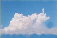
ScienceDaily (Jan. 12, 2009) — NASA and the National Science Foundation have successfully launched and demonstrated a newly designed super pressure balloon prototype that may enable a new era of high-altitude scientific research. The super-pressure balloon ultimately will carry large scientific experiments to the brink of space for 100 days or more.

This seven-million-cubic-foot super-pressure balloon is the largest single-cell, super-pressure, fully-sealed balloon ever flown. When development ends, NASA will have a 22 million-cubic-foot balloon that can carry a one-ton instrument to an altitude of more than 110,000 feet, which is three to four times higher than passenger planes fly.

"This flight test is a very important step forward in building a new capability for scientific ballooning based on sound engineering and operational development," said W. Vernon Jones, senior scientist for suborbital research at NASA Headquarters in Washington. "The team has further work to do to enable the super pressure balloon to lift a one-ton instrument to a float altitude of 110,000 feet, but the team has demonstrated they are on the right path."

Ultra-long duration missions using the super pressure balloon cost considerably less than a satellite and the scientific instruments flown can be retrieved and launched again, making them ideal very-high altitude research platforms.

The test flight was launched Dec. 28, 2008, from McMurdo Station, which is the National Science Foundation's logistics hub in Antarctica. The balloon reached a float altitude of more than 111,000 feet and continues to maintain it in its 11th day of flight. The flight tested the durability and functionality of the scientific balloon's unique pumpkin-shaped design and novel material. The material is a special lightweight polyethylene film, about the thickness of ordinary plastic food wrap.

"Our balloon development team is very proud of the tremendous success of the test flight and is focused on continued development of this new capability to fly balloons for months at a time in support of scientific investigations," said David Pierce, chief of the Balloon Program Office at NASA's Wallops Flight Facility at Wallops Island, Va. "The test flight has demonstrated that 100 day flights of large, heavy payloads is a realistic goal."

In addition to the super pressure test flight, two additional long-duration balloons have been launched from McMurdo during the 2008-2009 campaign. The University of Hawaii Manoa's Antarctic Impulsive Transient Antenna launched Dec. 21, 2008, and is still aloft. Its radio telescope is searching for indirect evidence of extremely high-energy neutrino particles possibly coming from outside our Milky Way galaxy.

The University of Maryland's Cosmic Ray Energetics and Mass, or CREAM IV, experiment launched Dec. 19, 2008, and landed Jan. 6, 2009. The CREAM investigation was used to directly measure high energy cosmic-ray particles arriving at Earth after originating from distant supernova explosions elsewhere in the Milky Way galaxy.

The super-pressure balloon was highlighted in the National Research Council's decadal survey "Astronomy and Astrophysics in the New Millennium," and will play an important role in providing inexpensive access to the near-space environment for science and technology.

NASA and the National Science Foundation conduct an annual scientific balloon campaign during the Antarctic summer. The National Science Foundation manages the U.S. Antarctic Program and provides logistic support for all U.S. scientific operations in Antarctica.

The Wallops Flight Facility is a division of NASA's Goddard Space Flight Center in Greenbelt, Md. Wallops manages NASA's scientific balloon program for the Science Mission Directorate. Launch operations are conducted by the Columbia Scientific Balloon Facility of Palestine, Texas, which is managed for NASA by the Physical Science Laboratory of New Mexico State University in Las Cruces.

Track the balloons online at: http://www.csbf.nasa.gov/antarctica/ice0809.htm
For information about the NASA balloon program visit: http://sites.wff.nasa.gov/code820

WEATHER NOTE

Tornado-proof dome under construction

A concrete dome capable of withstanding 300-mile-an-hour tornadoes is sure to become a landmark around the small Webster County town of Niangua, Webster County's emergency management director said of a project that will make major progress today.

A heavy plastic membrane that will act as a mold for concrete shot onto steel reinforcing bar will be inflated today, Emergency Management Director Bill Sexton said.

The dome will be the first monolithic dome approved for use by the Federal Emergency Management Agency for use as a tornado shelter, Sexton said.

The 61-foot-wide dome also can shelter students of the nearby Niangua School and other people, with a maximum capacity of 400.

Ninety percent of the structure's $311,000 cost is being financed by FEMA.

New emergency sirens going in rural areas

Rural Winona County residents will be better alerted in case of flood or tornado after county crews install 10 new sirens paid for by a $242,000 state grant.County commissioners earlier this month accepted the grant, which will pay to buy and install the sirens as early as this spring. The new sirens will alert residents to floods or tornadoes in areas that previously didn’t have sirens or are covered by aging sirens, County Emergency Management Director Bob Bilder said.

Officials in Stockton and Minnesota City said sirens there didn’t go off during a tornado warning in 2008, and Stockton leaders bought a new siren for their city last year.The new sirens won’t rely on electricity in an emergency: they’re solar-powered with battery backups, Bilder said.

New sirens are slated to be installed in the following locations:

Twin Bluffs near Pickwick on County Road 7
near the Gunderson subdivision in Goodview
Dresbach
Elba
Minnesota City
Green Terrace Mobile Estates near La Moille
In the mobile home park in Stockton
Near the Springbrook Addition on County Road 17,
And in the Hidden Valley Mobile Home Park.

County leaders still are trying to obtain funds to install six more new sirens, said Dave Belz, an emergency grants contractor for the county.Those locations are in Homer, Cedar Valley, Dakota, the Sunny Acres subdivision in Goodview, Minneiska and Whitewater State Park.

MARITIME NOTE

He serves hot soup in rough seas
By Mozart PastranoPhilippine Daily Inquirer


WHEN THE GOING GETS ROUGH, CHEF Choi goes beyond his comfort zone — he makes hot, steaming soup.

“It’s the most difficult thing to do in the galley of a ship caught up in big waves or some storm, and it’s SOP not to prepare soup during such times, but I have realized that it’s the best comfort food to whip up for my officers and crew,” confides the game 27-year-old chief cook of an international shipping lines.

His usual standbys are borsch, a traditional spicy Russian concoction made of beetroot, and eintofp, a German broth where all kinds of sausages and meats and beans broil in savory delectation.

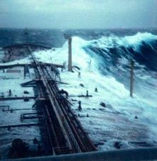
And he makes these soups every now and then when his ship crosses, say, the Mediterranean Sea and the treacherous Indian Ocean. The video he took of one Indian Ocean crossing shows his ship heaving and dipping and facing head-on waves as impossibly tall as churches.

But Chef Choi—full name: Ian Jul Banghal, of Cagayan de Oro City—waves off these stomach-churning moments, saying, “What I keep in mind are our destinations.” He rattles off: Palma de Mallorca or Party Island in Spain; Marseilles, France; Salerno and Palermo, Italy; Rotterdam, the Netherlands; Hamburg, Germany; Swansea and Liverpool, UK; Istanbul, Turkey; Antwerp, Belgium, and even picturesque Chennai, the third largest city in India.“Once,” he chuckles, “we snaked through the Suez Canal in Egypt for the longest time. We also docked at the mythical island of Thessalonike in Greece, and I explored its nooks and crannies. For spooky kicks, nothing can beat our adventure at Constanza in Romania, home of Dracula. Then there were those memorable safari trips in Kenya and Tanzania. And the time I saw the breathtaking lay of the land from a mountaintop in the Croatian city of Split. But my favorite outing of all was our stop at the Seychelles Island. It’s paradise.

Paradise and hellish waves spice up Chef Choi’s thrilling ride through life.

When he graduated from the prestigious Liceo de Cagayan High School in Cagayan de Oro in 1998, he wanted to do three things in college: study architecture, major in voice and pursue stage acting. At the time, however, there were not many college opportunities for these artsy things in the city. So his parents, Juliano, a CPA, and Agustina, a businesswoman, sent him to the nearest possible school for such inclinations—the University of Mindanao in Davao City, where he took up BS Architecture.

Upon graduation, he worked for Comfac Corp., a multinational firm engaged in designing and producing furniture and fixtures. He was the interior designer and estimator. (“I designed the products and made the budget and production estimates.”)

Growing up in the kitchen

It paid well and allowed him to continue his involvement with Pasundayag, a community theater group in Cagayan de Oro. He got to do a successful Valentine’s concert with his sister Julie Ann in a hotel ballroom.

But he was also into cooking and baking. His mother ran a thriving restaurant and catering business, and he continued to help out when he could. He was known for treating his friends to wondrous culinary adventures.

One friend happened to mention to him that there was a scholarship for aspiring chefs. The successful applicants would be flown to a culinary school in Germany for a one-year course. Even better, the graduates of that course would be automatically offered jobs in an international shipping line —as chefs traveling around the world on the high seas.

He applied for the scholarship. During the interview, he was told, “You don’t belong here. You have no professional experience in the kitchen.”

Nonplussed by such putdowns—his theater background apparently prepared him for these dramatic moments—he replied, “While it’s true that I’m an architect by profession, I grew up in the kitchen. Food is my passion. It’s my life. All this I bring with me wherever you’ll take me. And I’m a very good student. Teach me.”

He got the scholarship.

Lessons in Germany

During the six-month preparatory training in General Santos City and in Manila, he surprised even himself by topping the class. “My classmates were professional chefs and they knew everything, but I was a newcomer and I wanted to learn everything,” he says now, leafing through his certificates and photographs.

In Germany, he had a grand time savoring the hands-on lessons in the kitchen. “Our teachers were European chefs, and they shared their professional secrets. They were very exacting. But they were also very helpful. My enthusiasm and diligence endeared me to them. I absorbed everything, not just the kitchen tricks, their ways of seeing and preparing and presenting—but also the culture, their way of thinking. I learned a lot.”

Chef Choi began his new career as a second cook in a freighter that carried container vans to ports all over Europe. It was a brave, new world for him. “It was not so much work as fun because I got to see the world for the first time,” he beams.

He had no trouble adjusting to life in the ship either. “In theater,” he says, “I learned how to deal with all sorts of personalities and egos in such a way that I could work with anyone well so the show could go on. I applied this mind set in the ship, and I was able to navigate through the various nationalities and their cultural quirks.”

In no time at all, he was promoted chief cook. It was then that he decided he was not going back to architecture.

“Food and travel—these are my life now,” Chef Choi declares.

World’s windiest ocean locale

With the whole world as his stage, guess what is Chef Choi’s most prized souvenir from all his travels. What would you know, but a certificate attesting that he has sailed across the Equator.

“This was not even in my dreams,” he lets out.

“This is like magic. Suddenly I’m doing all this. The world is no longer out there. It’s here. And I’m traipsing about it like crazy.”

Thar she blows: A weather report from the world’s windiest ocean locale

A buoy anchored southeast of Greenland dutifully gathered wave and weather data in one of the world’s most hostile environments for more than five months, until the really rough weather of winter arrived and the buoy snapped free — but not before it confirmed satellite data suggesting the region is the world’s windiest for oceans.

The seas east of Greenland’s southern tip, a desolate point called Cape Farewell, are notoriously storm-tossed, says Ian Renfrew, an atmospheric scientist at the University of East Anglia in Norwich, England. As storm systems race eastward from northernmost Canada, their frigid winds either pass over Greenland’s kilometers-thick ice sheet and gain speed as they rush down its eastern slope, or they spill around the southern tip of the island. Waters in the area are likewise buffeted by storm systems that approach the island from the east and are then steered southward by Greenland’s icy blockade.

The region’s bad weather is what spurred Renfrew and his colleagues to tether a weather buoy to the 3-kilometer–deep seafloor there in the summer of 2004. At least 10 times that summer and fall, and sometimes for extended intervals, instruments on the floating platform measured winds exceeding speeds of 20 meters per second (about 45 miles per hour), the researchers reported January 13 at the annual meeting of the American Meteorological Society in Phoenix. Then on December 7, after less than six months in service, either high winds or huge waves — or both — pummeled the buoy and broke its tether.

Satellite-based sensors supplied data in recent years indicating that the ocean region east of Cape Farewell is the windiest in the world, says Renfrew. Furthermore, he notes, the buoy’s measurements suggest that the wind speeds inferred from the satellite data are accurate — a calibration that’s useful for analyzing similar data gathered for other parts of the ocean.
Renfrew and his colleagues estimate that 20 percent of the time winds at the site east of Cape Farewell blow even faster than 20 meters per second.

Rain machines: Tropical cyclones supply bulk of rain for some places

Tropical cyclones, the immense rotating storm systems that include hurricanes and their weaker cousins, typically last only a short time and cover a relatively small part of Earth’s surface. Nevertheless, at some latitudes these storms provide a substantial part of the region’s rainfall, a new study suggests.

For each year from 1998 through 2007, meteorologists tallied between 90 and 100 tropical cyclones that had peak wind speeds of at least 17.5 meters per second (about 39 miles per hour), says Christopher L. Williams, a recent graduate of Georgia Tech in Atlanta. Using satellite data, he and colleague Frank Marks Jr. of NOAA’s Hurricane Research Division in Miami estimated total worldwide rainfall for those years, as well as the amount of precipitation dumped only by the tropical cyclones.

Overall, tropical cyclones drop between 2 and 3 percent of the world’s rainfall, the researchers reported January 13 at the annual meeting of the American Meteorological Society in Phoenix. And that fraction is particularly small at latitudes near the equator, where rainfall is plentiful but the forces that drive large-scale atmospheric rotation and cause cyclones to develop are practically nonexistent, says Williams.

However, at latitudes between 15° and 30° — a swath that in the Northern Hemisphere stretches from central Honduras to just north of New Orleans — rainfall is less abundant, and tropical cyclones account for as much as 17 percent of annual rainfall.

Sea diamond sinking


Messing About In Ships Podcast


HAVE A WONDERFUL WEEKEND!

RS

Monday, January 19, 2009

New Power Line De-icing System Developed

New Power Line De-icing System Developed

(From Storm Reports. Org )

ScienceDaily (Jan. 13, 2009) — Dartmouth engineering professor and entrepreneur Victor Petrenko—along with his colleagues at Dartmouth and at Ice Engineering LLC in Lebanon, N.H.—have invented a way to cheaply and effectively keep ice off power lines.

The new proprietary technology is called a variable resistance cable (VRC) de-icing system. With only minor cable modifications plus some off-the-shelf electronics, the system switches the electrical resistance of a standard power line from low to high. The high resistance automatically creates heat to melt ice build-up or keep it from forming in the first place.

"The beauty of the VRC system is that it's fully customizable and is an affordable addition to the current manufacturing and installation process," said Gabriel Martinez, Ice Engineering's Vice President who studied under Professor Petrenko while earning his M.S. in engineering sciences from Dartmouth. "And it works without causing any service interruption whatsoever," he added.

"The technology builds on many years of research in materials science, power electronics, and ice physics with my colleagues at Dartmouth such as Professor Charles Sullivan, an expert in power electronics and a co-inventor of the VRC de-icer," said Petrenko who is founder, Chief Technology Officer and Chairman of the Board of Ice Engineering.

Ice Engineering plans to install and test a full-scale VRC system prototype on a section of power line in Orenburg, Russia, in late January 2009. The company is also currently negotiating full-scale installations of VRC in other regions of Russia and in China.

Martinez says the changes in manufacturing and installation required to implement the VRC system would result in a less than 10 percent increase in overall cost. Since utility companies normally replace 3 percent of their cables every year, the system could be installed as part of the regularly scheduled maintenance process and still achieve a significant portion of the installation by the time the next major storm hits.

Furthermore, the life span of the de-icing system would match or exceed the life-span of the utility cable, approximately 30–50 years. The system would pay for itself during the next storm by practically eliminating the cost of fixing downed cables and power outages due to ice and snow, according to Martinez.

Another benefit to the VRC system is that utility companies using the system would have full control over its functionality, says Martinez. Time, temperature, and location can all be adjusted manually or set and controlled automatically with electronic sensors.

Ice Engineering in Lebanon, N.H. develops and licenses technology and applications that enable products that interact with ice and snow to perform significantly better than ever before. Dartmouth engineering professor Victor Petrenko is the primary inventor of the technology. Ice Engineering was founded by Petrenko as a Delaware LLC in April of 2001 to commercialize the technology in specific industries.

Weather Note

NOAA Twin Otter Aircraft to Support West Coast Ocean Research, Management

Highly capable plane will be based in Monterey, Calif.
January 12, 2009


Senior federal officials today dedicated a specially equipped twin-engine NOAA aircraft that will support ocean research and management along the West Coast. The NOAA Office of Marine and Aviation Operations is basing the plane and flight crew in Monterey, Calif., to meet the needs of NOAA programs and national marine sanctuaries.

NOAA will use the DHC-6 Twin Otter aircraft to observe marine mammals and other living ocean resources, conduct offshore and coastal surveys, and support emergency response and enforcement missions.

“The highly modified aircraft is well-suited for offshore and coastal surveys and marine resource management,” said John H. Dunnigan, NOAA assistant administrator for the National Ocean Service. “We are pleased that this valuable asset will serve the West Coast.”

Built by de Havilland Canada, the Twin Otter is a maneuverable, versatile aircraft that can be flown at slow speeds and in tight circles. The NOAA version of this high-winged turboprop plane is equipped with color weather radar, dual GPS/Loran-C navigation systems, radar altimeter, and camera ports in the nose and belly areas. A standard flight crew consists of two pilots and up to six scientists.

By basing the aircraft in Monterey, NOAA will have the ability to quickly monitor and protect the waters off the West Coast and Alaska, including five national marine sanctuaries that encompass more than 9,000 square nautical miles of open ocean and remote, rugged coastlines from Washington to the Mexico border. They include Olympic Coast National Marine Sanctuary in Washington, Cordell Bank and Gulf of the Farallones national marine sanctuaries off San Francisco, Monterey Bay National Marine Sanctuary, and Channel Islands National Marine Sanctuary off Santa Barbara.

As part of the NOAA fleet of research and survey ships and aircraft, the NOAA Twin Otter will be operated, managed and maintained by NOAA Corps officers and civilians with the NOAA Aircraft Operations Center. Specific research instrumentation or remote sensing technologies will be supplied by program scientists.NOAA understands and predicts changes in the Earth's environment, from the depths of the ocean to the surface of the sun, and conserves and manages our coastal and marine resources.

Top International Weather Events: 2008

Guest contributor Robert Henson recently ran down his selection of highest impact U.S. weather events of 2008 (1-5, 6-10), while CWG's Ann Posegate reviewed her choice of last year's top D.C. area weather stories.

Weather, of course, knows no boundaries. Year in and year out, extreme weather from around the world offers a treasure trove of fascinating phenomena, many of which have sobering consequences for those in harm's way. International weather can also have significant impacts in the U.S.

Keep reading for my selection of the top 2008 international weather events...

For example, floods and droughts in agricultural centers around the globe can lead to food shortages and price increases in supermarkets here; tropical storms that devastate foreign lands can mean massive U.S. financial aid, ultimately affecting your taxes; and ocean storms can disrupt shipping of imports and exports (and provide great waves for surfing in California and Hawaii!).

I don't ascribe significance to the ordering, since generally I find it too difficult to judge the importance of any single event -- both weather conditions and impacts on human activities, life and property must go into such judgements. Note, too, that I'm avoiding (for now) the question that some might ask about possible links between extreme weather events and climate change.
Cyclone Nargis, a monstrous Category 4 hurricane that developed over the North Indian Ocean, struck Burma (also known as Myanmar) on May 2.

It was not only 2008's most deadly tropical cyclone (estimated 150,000 people killed), but also believed to be second only to Typhoon Nina (1975) as the deadliest named storm on record. See these posts on Nargis from the Capital Weather Gang: Inside the Burma Cyclone and Bangladesh's Example for a Post-Nargis World.

On March 1-2 heavy rains accompanied by hurricane force winds (up to an estimated 125 mph) ripped across central Europe. Thirteen people were killed along the storm's trail of destruction (tens of millions of dollars), which included cars blown off roads, roofs ripped off houses, thousands of felled trees, and bridges collapsed into flooded rivers. It was this storm that led to the near crash (and remarkable, must-see video) of a Lufthansa Airbus A320 as it attempted to land at Hamburg International Airport during high winds.

Flooding of the Kosi River, between Nepal and India, on Sept. 2, 2008 (top), and pre-flood conditions in June (bottom). Courtesy NOAA. Click here to enlarge image.

The 2008 Southeast Asian Monsoon season started earlier than it has in more than a century, and was among the deadliest and most destructive seasons on record. Massive flooding from torrential monsoon rains between June and September resulted in 2,600 deaths and displaced millions of people from inundated villages throughout southern Asia, including India, Bangladesh, Pakistan, Nepal and Vietnam.

Tropical Cyclone Ivan, a borderline Category 4 hurricane, slammed into Madagascar on Feb. 17. Ivan has been described as one of the strongest ever to hit the island nation off the southeastern coast of Africa. It was blamed for at least 22 deaths.

Between Jan. 25 and Feb. 26, a series of winter storms walloped large portions of southern and central China with heavy snow, icing and extreme cold. The winter weather -- China's worst in half a century -- is blamed for 129 deaths and caused massive disruptions in power and transportation, just as millions of Chinese were traveling through the country in celebration of the Chinese New Year.

In South America, a large part of Argentina, Uruguay and Paraguay experienced a prolonged and intense drought during most of 2008, which caused severe damage to agriculture. Heavy rainfall in November caused severe flooding and deadly mudslides in southern Brazil. In what is considered the country's worst weather disaster ever, dozens were left dead and millions isolated in cities behind overflowing rivers.

Widespread heavy rains with severe thunderstorms, damaging winds, hail, and flash floods occurred across much of Australia in November. These events largely ended a long-term drought characterized by severe water shortages and extensive crop failures.Though I've not found it on any list of top weather events of 2008, my sentimental favorite goes to the remarkable and unusual hail (or was it snow?) storm in the vicinity of Exeter in southwest England.

MARITIME NOTE

Scientists Launch First-Ever Exploration of Antarctica's Deep-Sea Vents

Also see Stunning Photos of Antarctica

COMMUNITY NEWS British Antarctic Survey scientists and colleagues from the National Oceanography Centre, Southampton, the Zoological Society of London and Woods Hole Oceanographic Institution in the USA are set to be the first to investigate in detail the creatures living around hot water vents surrounding the coldest continent, Antarctica.

The team is onboard the BAS research ship the RRS James Clark Ross on a voyage to locate and explore life around two poorly understood deep-sea habitats — hydrothermal vents and cold seeps. The five-week NERC-funded project called ChESSO, or Chemosynthetic EcoSystems in the Southern Ocean, is part of a ten-year scientific initiative known as the Census of Marine Life.

The research cruise begins on 14 January and finishes on 18 February.
They will be reporting regularly on classroomatsea.net

American Meteorological Society Recognizes Navy ContributionStory

PHOENIX, Ariz. (NNS) -- The commander of the Naval Meteorology and Oceanography Command (NMOC), was named one of 28 new Fellows of the American Meteorological Society (AMS), the nation's leading professional society for scientists in the atmospheric and related sciences, at the AMS Annual meeting in Phoenix Jan. 12.Rear Adm. David W. Titley, along with other awardees, will be recognized at a banquet Jan. 14. The Fellow is given to an individual for recognition of outstanding contributions to the atmospheric or related oceanic or hydrologic sciences, or their applications, during a substantial period of years.

Only two-tenths of one percent of AMS membership is approved as Fellow each year. "I am humbled to be named an AMS Fellow. As a professional meteorologist, this is a significant honor for me," Titley said. Titley earned a doctorate in meteorology at the Naval Postgraduate School in Monterey, Calif., on tropical cyclone intensification.A native of Schenectady, N.Y., Titley was commissioned through the Naval Reserve Officers Training Commissioning program, after graduating from Pennsylvania State University. He earned a master's in meteorology and oceanography at the Naval Postgraduate School.
He attended the Massachusetts Institute of Technology Seminar XXI on Foreign Politics, International Relations and National Interest from September 2003 to June 2004.Titley's awards include the Legion of Merit, Meritorious Service Medal, Navy Commendation Medal, Navy Achievement Medal, and various unit and service awards. All awards were presented by the U.S. Navy and awarded throughout his 28-year career.NMOC, based at Stennis Space Center, Miss., is a Navy operational command with about 3,500 military and civilian personnel worldwide. The command provides weather and ocean forecasts and geospatial information and services for Navy operations.

Founded in 1919, the AMS has a membership of more than 12,000 professionals, professors, students, and weather enthusiasts. AMS publishes nine atmospheric and related oceanic and hydrologic journals, sponsors multiple conferences annually, and directs numerous education and outreach programs and services. For more news from Naval Meteorology and Oceanography Command, visit www.navy.mil/local/cnmoc/.


Container Vessel Crashes Into Barrier Reef

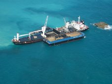
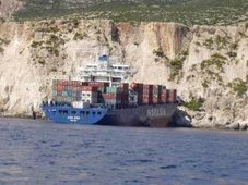
A cargo ship is tonight lodged on Belize’s barrier reef system. It is the Westerhaven – a Netherlands registered vessel that left Belize last night enroute to Santo Tomas in Guatemala. It should have been there by now but while leaving Belize it ran into bad weather and ran aground. 7NEWS travelled 32 miles from the city to the accident site and tonight we’ll show you the ship and underwater footage of the damage it did as it tore through Belize’s reef.

Keith Swift Reporting, We found the Westerhaven cargo ship where it has been since last night – stuck on the reef 32 miles from Belize City in an area near Caye Glory. It ran aground on the reef while sailing out of Belize enroute to Guatemala. This afternoon we met the coast guard on site with an assessment team.

Direl Garrido, Coast Guard“We were called out to assist the DOE and an assessment team to come and check the vessel that grounded here.”

Keith Swift,Have you been on the boat?

Direl Garrido,“No, no.”

Keith Swift,Have you spoken to anyone who has been on the boat?

Direl Garrido,“No sir, nothing. All the information we get from our headquarters.”

Keith Swift,So it is lodged on the reef?

Direl Garrido,“It is aground on the reef, yes.”

Keith Swift,Do you know what efforts are being made to move it?

Direl Garrido,“Right now the assessment team is just conducting an assessment and then based on the result then they will make a decision.”

As the footage shows- it is a large vessel – estimated to be about 100 meters long. A massive ship and it did extensive damage. Marine scientist Melanie McField accompanied us on the boat to the accident site and she says a large area of pristine reef has been destroyed. This is underwater footage she shot with her camera. She says it is the worst reef accident she has ever seen.

Melanie McField, Marine Scientist“This is by far the worst I have ever seen. I’ve never seen anything like this. It is unbelievable. I even saw blast fishing in Indonesia and this looks much worse because it is the whole area.

The reef has been completely levelled, basically from the stern to after the boat. It seems as if the boat just came in on top of, you know the reef has these spurs, it is like hills of corals, valleys of sand, and all the hills of corals have just been scraped clean, levelled. I have never seen anything like it; usually damage is a little bit spotty. And down there near the front of the boat there are areas where big coral heads are knocked over but here in the middle, the whole think is flattened, actually levelled like a parking lot.”

Keith Swift,And what is the size of the area we’re talking about?

Melanie McField,“Well it is basically it is the length of the boat, maybe a little bit less. The two ends aren’t quite as bad. The length of the boat and then out to at least this point where we are here so that’s bigger than a football field.”And as bad as it is – McField the damage has been done and it should be easily moved.

Melanie McField,“There are a few places where it actually pushed into the reef, the spurs as you get towards the reef crest there are a little bit lower but the boat is just pushed on to about two of them so I don’t think they are going to have a lot of trouble getting it off because as you pull it out there is nothing to block the path, all the coral is gone so it should be fairly easy to take it off. It is in a weird position because it is sideways to the current but I don’t think it will be too bad. All of this is levelled so they are not going to hurt much if they pull it off this way.”

Keith Swift,How far is this from the channel?

Melanie McField,“Well they came out the English Caye channel. I don’t know what the legal distance is offshore that they are supposed to travel but they shouldn’t have been travelling anywhere close to the reef crest, especially at night and they should have known where that was with their GPS equipment.”

The ship’s owner – who we are told is on his way to Belize – will be more than likely be fined but McField says no dollar amount can measure the damage.

Melanie McField,“Each square meter of reef is worth something like US$2,000. I haven’t calculated yet but we’ll get out the numbers and it is a lot of square meters that is damaged here and so there should be a considerable fine.”

Keith Swift,What will be the effect on the wider reef system?

Melanie McField,“Well the rest of the reef system, there is some sedimentation coming off of the pulverized reef but that’s pretty negligible. The main thing is that we’ve lost some important habitat. This is really healthy reef. We don’t have a lot of healthy reef, the eco-system report card that we came out with earlier this year was pretty bleak; most of our reef is in poor condition. But this particular chunk of reef is pretty healthy.

This is not the first time it has happened. There was the grounding of a cargo ship back in late November and I think we really need to be tough on our regulations and with Coast Guard, Port Authority, Fisheries, and DOE and get everyone to really come down on these ships. I don’t understand why this is happening.”

The assessment team was still onboard the ship when we left. The ship’s agent in Belize is Eurocaribe Shipping. As we mentioned it was bound for Guatemala and had stopped in Belize for only 4 hours to drop off a few containers. It is registered in the Netherlands and the captain was Fritz Schroeder. It is of note that this is only Schroeder’s 3rd trip as the captain of the Westerhaven to Belize. The owner is on his way to Belize. Tomorrow he is expected to hire a salvage company to tow the ship off the reef.

On a final note – if we use Melanie McField’s math – the ship damaged 10,000 meters of reef which would amount to US$20 million. McField is a marine research scientist with 18 years experience.

RS