Showing posts with label maritime safety. Show all posts

Friday, January 30, 2009

Weathernews launches Global Sea Ice Information website

Weathernews launches Global Sea Ice Information website

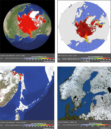
The Global Ice Center has been collecting and monitoring global sea ice data, including ice concentration, ice thickness and ice drift, since its opening in July 2008, in order to provide unified global sea ice information to shipping companies.

The Global Ice Center’s information covers such data as sea ice concentration, thickness and drift over not only the Arctic Sea, but also the Baltic Sea, the Sea of Okhotsk and the Gulf of Saint Lawrence.

Recently, sea ice data from the Global Ice Center was utilized for a successful and safe voyage through the Baltic Sea by an LNG tanker operated by one of the world’s major shipping companies.

In the near future, we will provide historical sea ice data, such as the first day of freezing, the first day of melting, the average rate and the largest amount of sea ice area.

Weathernews believes that our official Global Ice Center website is able to support many shipping vessels across the world, in order to contribute to the safe passage of the vessels that brave the icy waters of the Arctic Ocean.

[Major Characteristics of the Global Ice Center]

AnalysisThe Global Ice Center provides analysis information of sea ice conditions in all affected regions, using data from our original observation network and from organizations of various countries.

ForecastThe Global Ice Center original “I-SEE” model predicts sea ice concentration, thickness and movement out to two weeks, to support safe ship operation.

NetworkThe Global Ice Center, by using innovative technology in academia applied to sea ice data, is able to provide vital information to maritime companies, as well as feedback from ship reports.

Weathernews Inc. is the world's largest private weather service company headquartered in Japan. It is the only global weather content maker that employs over 600 staff (including more than 200 meteorologists) in offices in 32 cities in 16 countries and regions, including United States, United Kingdom, Germany, Netherlands, Italy, France, Spain, Australia, China, Japan, Korea, Malaysia, India, Nepal and Taiwan.

WEATHER NOTE

Waterspout causes chaos for boaties

A boating couple from the Coromandel Peninsula who were singled out by a freak of nature on the first day of their holiday have not been put off the lifestyle.

Anne Louden and her husband John were watching an electrical storm last night from their anchorage off Great Barrier Island, when the sky became dark. Just as they went below deck, a water spout picked up their nine metre launch, threw it into the air and dumped it back down. The couple suffered only a few cuts and bruises.

Ms Louden says she has seen disasters on TV and could not imagine ever being part of such an event.

"It's just one of those weird, freaky things that happens. You can't be put off boating, you really can't, it's a spectacular lifestyle. But it gives you an appreciation of weather and caution."
Ms Louden says none of the other 30 or so boats in the bay were touched.

Waterspouts occur when layers of high, cool air blow over a body of water such as a lake, river or ocean sweeping up moist air from below.

Tornado Intercept Audio


MARITIME NOTE

Lack of systems training poses threat to shipping
Electronic navigation aids are not being properly used, says marine safety body


The UK's sea safety body has warned that computerised navigation systems are steering large vessels into dangerous shallows because officers have insufficient training in their use.

The Department for Transport's Marine Accident Investigation Branch (MAIB) sounded the alert after over-reliance on an incorrectly used Electronic Chart Display Information System (ECDIS) resulted in the temporary grounding of the cargo ship Performer on Harborough Sand on its way to Grimsby in May 2008.

A subsequent investigation by MAIB warned: "The use of ECDIS has steadily increased in recent years, and it is disturbing that the number of accidents resulting from the incorrect use of ECDIS and ECS [Electronic Chart Systems] through poor system knowledge has also risen.

"ECDIS will soon replace paper charts as the primary planning and monitoring media onboard most vessels, but the system can only realise its potential benefits to maritime safety if all mariners who are expected to use the equipment at sea are properly trained."

Many ships' officers, including the master of Performer, were only formally trained in the use of paper charts, although many have used electronic aids. An ECDIS installed in 2007 was Performer's primary means of navigation, but none of her bridge watchkeeping officers had been trained in its use.

MAIB cited a number of accidents in recent years in which misuse of ECDIS or ECS has been a contributing factor, including a cross-Channel ferry that headed for shallows in 2004 without its ECDIS issuing a warning because it had not been correctly set up.

And in January last year a vessel hit a submerged wreck near Dover, severely damaging her propellers, because the wreck was not shown on the ECS display. "The need for mandatory training in ECDIS is compelling," said the MAIB report.

Proposed international regulations require ECDIS in most large new passenger vessels and large cargo boats and tankers, and its retro-fit over time to existing vessels.

Dangers At Sea


January 2009...gone already! Have a great weekend!
RS

Wednesday, January 28, 2009

NOAA: 2008 Global Temperature Ties as Eighth Warmest on Record

NOAA: 2008 Global Temperature Ties as Eighth Warmest on Record

The year 2008 tied with 2001 as the eighth warmest year on record for the Earth, based on the combined average of worldwide land and ocean surface temperatures through December, according to a preliminary analysis by NOAA’s National Climatic Data Center in Asheville, N.C.

For December alone, the month also ranked as the eighth warmest globally, for the combined land and ocean surface temperature. The assessment is based on records dating back to 1880.

The analyses in NCDC’s global reports are based on preliminary data, which are subject to revision. Additional quality control is applied to the data when late reports are received several weeks after the end of the month and as increased scientific methods improve NCDC’s processing algorithms.

NCDC’s ranking of 2008 as the eighth warmest year compares to a ranking of ninth warmest based on an analysis by NASA’s Goddard Institute for Space Studies.

The NOAA and NASA analyses differ slightly in methodology, but both use data from NOAA's National Climatic Data Center – the federal government's official source for climate data.

Global Temperature Highlights – 2008

The combined global land and ocean surface temperature from January-December was 0.88 degree F (0.49 degree C) above the 20th Century average of 57.0 degrees F (13.9 degrees C). Since 1880, the annual combined global land and ocean surface temperature has increased at a rate of 0.09 degree F (0.05 degree C) per decade. This rate has increased to 0.29 degree F (0.16 degree C) per decade over the past 30 years.

Separately, the global land surface temperature for 2008, through December, was sixth warmest, with an average temperature 1.46 degrees F (0.81 degree C) above the 20th Century average of 47.3 degrees F (8.5 degrees C).

Also separately, the global ocean surface temperature for 2008, through December, was 0.67 degree F (0.37 degree C) above the 20th Century average of 60.9 degrees F (16.1 degrees C) and ranked tenth warmest.

Global Temperature Highlights – December 2008

The December combined global land and ocean surface temperature was 0.86 degree F (0.48 degree C) above the 20th Century average of 54.0 degrees F (12.2 degrees C).

Separately, the December 2008 global land surface temperature was 1.22 degrees F (0.68 degree C) above the 20th Century average of 38.7 degrees F (3.7 degrees C) and ranked 14th warmest.

For December, the global ocean surface temperature was 0.74 degree F (0.41 degree C) above the 20th Century average of 60.4 degrees F (15.7 degrees C) and tied with December 2001 and December 2005 as sixth warmest.

Other Global Highlights for 2008

The United States recorded a preliminary total of 1,690 tornadoes during 2008, which is well above the 10-year average of 1,270 and ranks as the second highest annual total since reliable records began in 1953. The high number of tornado-related fatalities during the first half of the year made 2008 the 10th deadliest with a 2008 total of 125 deaths.

Northern Hemisphere snow cover extent in December was 16.95 million square miles (43.91 million square kilometers). This was 0.17 million square miles (0.43 million square kilometers) above the 1966-2008 December average. Northern Hemisphere snow cover extent was below average for most of 2008.

Arctic sea ice extent in 2008 reached its second lowest melt season extent on record in September. The minimum of 1.80 million square miles (4.67 million square kilometers) was 0.80 million square miles (2.09 million square kilometers) below the 1979-2000 average minimum extent.

NOAA understands and predicts changes in the Earth's environment, from the depths of the ocean to the surface of the sun, and conserves and manages our coastal and marine resources.

WEATHER NOTE

Officials send letter to Coast Guard asking for thorough investigation

Gloucester - The following letter was sent on Jan. 9 to Rear Admiral Dale Gabel, First Coast Guard District, Boston:

Dear Rear Admiral Gable,

We are writing to seek your assistance with an urgent request regarding the recent tragic loss of the Gloucester fishing vessel Patriot. In the wake of this incident, which claimed the lives of experienced fishermen Matteo Russo and Giovanni Orlando, thorough answers to many questions are necessary.

We are award that the Coast Guard has initiated an investigation into this incident, and that the First District and Sector Boston personnel are continuing to examine available information regarding all of the factors involved in the loss of the Patriot. We urge you to maintain and intensify this effort, and to expedite it as much as possible.

Yet we firmly believe that the information surrounding the loss must be significantly expanded to include the position, condition and all other pertinent facts available from examination of the Patriot in its present position. We thus request, in the strongest possible terms, that the Coast Guard undertake an underwater investigation of the vessel as soon as possible, utilizing either professional divers and/or submersible vehicles.

We are aware that this request is extraordinary, but yet this incident is as well. Thorough answers, to the extent possible must be developed to the haunting questions that remain.

Among those questions are how a sound vessel, with an experienced crew could so suddenly be lost in the sea and weather state that existed on Jan. 1 and 2. Understanding what led to the loss of the Patriot and Matteo Russo and Giovanni Orlando is critical, and conducting a subsurface investigation will yield answers that are vital for investigators, other Coast Guard personnel, the families of those who have been lost, those who must return to sea as fishermen, and the public.

Accordingly, please initiate such an investigation as soon as it may be undertaken. Thank you for your consideration of this request, and please do not hesitate to contact us if we may be of any further assistance, or to discuss this matter further.

Sincerely
State Sen. Bruce Tarr
State Rep. Ann-Margaret Ferrante
Mayor Carolyn Kirk

Cc: Sen. Kennedy, Sen. Kerry, Rep. Tierney


MARITIME NOTE

Coast Guard reminds mariners to prepare, exercise caution in high surf

HONOLULU — The U.S. Coast Guard warns boaters and beach goers to exercise caution in all Hawaiian waters for the next few days due to potentially high winds and coastal area flooding.
The Coast Guard reminds all who work and play in island waters that conditions may be more dangerous during potentially high surf conditions.

In addition, marinas and boaters are reminded to check that boats in port are properly secured, bilge pumps are functional, and all loose items are removed from decks. Report any boats adrift, pollution or other maritime emergencies to the Coast Guard Sector Honolulu Command Center at 808-842-2600 or to the National Response Center at 800-424-8802.

The National Weather Service — www.noaa.gov — has posted hazardous weather outlooks for the entire state of Hawaii to include gale force wind warnings, small craft advisories and high surf advisories. The boating public is strongly encouraged to pay close attention to local weather forecasts before leaving port.

Here are some tips for those who choose to go out on the water during the potentially heavy weather:

Leave a float plan with a responsible individual who knows your intentions, location and who they should call if you do not return as scheduled.

Wear a Coast Guard-approved life jacket and set the example for your passengers or paddling partners.

Carry a marine band VHF radio and/or other reliable means of communication.

Be prepared for the shock of sudden immersion and the disabling effects of cold water. Plan for the worst: dress as though you are going to get wet and be cold.

Maintain awareness on the water — be aware of activity around your vessel including changing weather, and always know your location.

Be responsible — know that alcohol and drugs cause accidents and sometimes death.

Don’t boat alone — boating alone is not recommended. Recreational paddlers canoeists and kayakers often travel with a single craft and one partner, or even solo, but it is recommended you canoe, kayak or boat with at least three people or two craft.

Know your limitations paddle — be honest with yourself and your companions. Your life and the lives of those in your party may depend on how everyone understands each other’s capabilities.

Tags: , ,

M.V. New Carissa Wreck Removal TITAN


RS

Tuesday, January 27, 2009

New Zealand Tries to Avoid a Rescue Bill

New Zealand Tries to Avoid a Rescue Bill

From the The Antarctica Blog

Tourism in Antarctica isn't like tourism in other extreme environments - in some ways, it's much more dangerous.

Take any indicator - temperature, ocean conditions, accessibility - and Antarctica in a sense wins because it is colder, icier, and more difficult to get to than anywhere else. So it makes sense that New Zealand would try to block an adventurous rower from his plans to row around Antarctica by himself.

Maritime New Zealand (MNZ), the branch of government responsible for marine safety, would be responsible for rescuing the rower, Oliver Hicks, in case of an accident. MNZ believes that an accident is almost inevitable because of the harsh conditions on the Southern Ocean. Hicks will be using a boat that is powered by rowing but has cabins in which he can sleep, prepare food, and store supplies.

The boat is also allegedly designed to withstand Southern Ocean conditions.MNZ has great reason to be skeptical of Hicks' plans, however.

Previous attempts have resulted in accidents requiring rescue, and in one case an adventurer drowned. Rescue missions are costly and put rescuers themselves in danger. Hicks' journey would take him 500 days and would cover 24,000 square kilometers, or just under 15,000 miles.

He plans to halt for a few months during the brutal Antarctic winter on the island of South Georgia.Hicks' response to New Zealand's refusal to let him set out on his journey was to travel to Australia.

Australian officials are hardly excited about the project, but unlike their New Zealand counterparts cannot stop him from leaving. If he needs rescuing, MNZ will still be on the hook.

Hicks has already accomplished some impressive feats of solo rowing - he is the only person to have rowed from America to the United Kingdom alone - and feels confident that he is capable of completing his mission and staying safe.This incident underscores the need for special tourism policies for Antarctica.

The human desire to undertake difficult and dangerous adventures is admirable, but is disregarding the wishes of those who would have to rescue you also admirable? It's not as if MNZ could just ignore Hicks in the event of an accident, even if he wanted them to do so. It seems a shame that governments are hamstrung in this way.

While this type of tourism doesn't represent the kind of environmental threat that we at ASOC are most concerned about, it does point to the overall lack of regulation for Antarctic tourism that would protect both people and the environment.

Laws and rules no doubt deaden the souls of expeditioners, but they keep people safe and prevent unnecessary crises.

Posted by Antarctic and Southern Ocean Coalition at 7:31 AM

WEATHER NOTE

Fight against historic flood protects city

Record flooding of the Stillaguamish River filled low-lying areas south of the Stanwood city limits, leaving Marine Drive under more than 3 feet of water last week.

“It was close,” said Stanwood Camano Fire and Rescue (SCFR) Chief Mike Ganz Friday morning. “We are finally out of the woods.”

River gauges showed the Stillaguamish to be at or near record depth by 6 p.m. Thursday. An emergency earthen wall along SR 532 held back the cresting flood, and with the cooperation of Burlington Northern Santa Fe (BNSF), the city sandbagged the tracks and Marine Drive to keep east Stanwood dry.

By Thursday evening, the governor’s office had declared a state of emergency for most of Snohomish County.

On Friday morning, it seemed as if the worst had passed.

After consultation with BNSF officials, tracks were reopened by 10 a.m. On Monday, Fort Freberg, a 7-foot-tall emergency dike named for retired firefighter Jack Freberg, still stands as a reminder of the Herculean effort that saved the city.

Mike Simmons, SCFR emergency manager, said he is in no hurry to remove the fortification. “You really don’t want to pull these things down too quickly,” said Simmons. Ganz credits the volunteers who worked alongside city and emergency crews.

“These folks — they’re awesome,” he said. “They did a fantastic job.”

According to Ganz, many different agencies and individuals — some from other counties — worked hand-in-hand to prevent a tragedy.

In addition, inmate work crews from Monroe Correctional Complex worked with city crews filling sandbags and providing them to residents.

U.S. Army Corps of Engineers worked alongside city and county crews to shore up temporary protective dikes and repair levees.

“They helped plug a break near 95th Avenue NW,” said Ganz. Rebecca Hover, Snohomish County Sheriff’s Office public information officer, said rescue teams were deployed swiftly to prevent the loss of life.

“We responded to dozens of calls, but it’s impossible to say how many calls we went on or how many people we rescued — there’s really no way to keep count,” said Hover. “Rescuers would get a call to go to one house to help people out and then they’d find more people who needed help out of the area or neighborhood.”

Most of the calls involved people needing help out of their houses or businesses; they also helped people who got stuck in their vehicles as they tried to drive through the flood waters, she said.

Christian Davis, North County Fire/EMS public information officer, said their crews were kept busy with rescue operations.

“We had nine water rescue calls, with 14 victims removed from the flooded areas,” said Davis. “We (also) assisted with a sandbagging request by DEM (Department of Emergency Management) for the city of Stanwood.”

One unique moment, said Davis, was when a 100-gallon propane tank washed up on the shore in the Warm Beach area.

Crews secured the tank, stopped the leak and notified a company for its removal, he said. Stanwood’s emergency operations center went into action Wednesday morning and remained open until 4 p.m. Friday.

“The final damage estimates haven’t come in yet,” said Simmons. “Within the city limits, it will probably be very low.”

Most of the real damage happened to homes and farms south of Stanwood, he said. For many, the days and weeks ahead will mean clean-up and salvage operations. Claims for assistance should be started immediately, said Simmons. Only damage from the floods occurring on or after Jan. 6 should be reported.

“The primary focus now is to compile damage reports from Snohomish County residents and businesses to qualify for federal disaster aid and speed relief to our citizens,” he said.

“Do not wait for a professional estimate of cost or an insurance adjustor document to fill these forms out.”

Receding water has allowed for the reopening of Marine Drive, but several streets remained navigable only by boat at NEWS deadline.

Dianne White, Stanwood mayor, said she is filled with pride after witnessing the ‘flood fight’ play out.

“The flood was an event that showcased the quality of the citizens of Stanwood,” she said. The seamless response of emergency crews and the scope of volunteerism prevented disaster on a wider scale, she said.

“Without the help of the Army Corps of Engineers, we would have lost our waste water treatment plant,” said White.

Flood waters entered offices at the plant, though damages are reported as minimal. Water processing and quality were not affected.

“The fire department’s Support 99 group as well as the Salvation Army worked tirelessly to meet the needs of victims, volunteers and EOC workers throughout the event,” she said. White applauded the efforts of Red Cross volunteers, Stanwood/Camano School District personnel and staff from Josephine care facility whose residents were evacuated to Stanwood High School.

“What distinguishes Stanwood is the ‘can do’ attitude of our citizens and businesses,” said White. “We had over 400 sandbag volunteers, who filled bags at Index Sensors and Twin City Foods parking lots.”

White said she is grateful for food provided to volunteers by QFC, the family of Carolyn Lund, and numerous citizens.

Flood gates erected to help drain the flood performed better than expected. On Friday, the gates were draining at 1,500 cubic feet per second and lowered the flood water by 46 inches in one day.

“This new addition to our flood fighting arsenal is serving to get Marine Drive and the railroad tracks open much sooner than past years,” she said. “The Stillaguamish Flood District and Max Albert are to be commended for their persistence in getting this structure built.”

Chuck Hazleton, Stillaguamish Flood Control District commissioner, said he was overwhelmed by the success of the flood control gates in operation near Marine Drive.

“The flood gates are working better than we had expected,” said Hazelton. “The velocity of the discharge is more than we anticipated.”

Built in September 2007, the control system — a concrete structure — has 10 gates to create a nonporous channel back into the river.

The overall project cost $175,000, and the city subsidized $30,000 towards the construction of the gated system.

“It was definitely money well spent,” said Hazelton.

Sen. Mary Margaret Haugen (D), of Camano Island, said the legacy of this flood event will be how residents saved their city.

“One of the merits of living in a small community is how your neighbors reach out to help,” said Haugen. “I am so proud of the way people in the Stanwood area rallied to help each other.”

Haugen said she believes Stanwood was spared because of all the people who helped. “It's really tragic how many people in our state were affected,” she said. “You just can't imagine how bad this is until you've experienced it.”

The flooding was yet another blow to a region already hit hard by bad weather, said Haugen.

MARITIME NOTE

Coast Guard warns mariners be aware of ice conditions in Delaware Bay

PHILADELPHIA - The Coast Guard Captain of the Port Sector Delaware Bay in Philadelphia has set ice condition three Thursday and is warning mariners to be aware of ice in the Delaware Bay and River.

Ice condition three is set when weather conditions are favorable for the formation of ice in navigable waters. All masters, ship agents, and owners and operators of all vessels, marine facilities and marinas should review and adhere to the seasonal ice procedures listed below. These criteria were developed in partnership with the Mariners’ Advisory Committee for the Delaware Bay and River. Ship agents should generally act as liaison between the Coast Guard and their vessels.

When ice is present, but less than two inches, vessels must have a propulsion system with a minimum of 1000 horsepower, and be able to maneuver un-assisted through the ice without needing to stop, back off and ram the ice.

When ice is present in the C and D canal, only steel-hulled vessels whose propulsion systems are in excess of 1000 horsepower may transit the canal.

Vessel convoys will not be directed for ice or ice build of less than two inches, provided vessels can maintain headway. For ice conditions of two inches or greater, the Captain of the Port, in conjunction with the MAC, will consider implementing a plan that includes directing vessel convoys.

Vessel moorings should be checked frequently to ensure the vessel is adequately moored.

Vessels at anchor should maintain their engines on standby at all times.

Vessels at anchor should ensure that proper bridge watches are stood at all times.

Vessel sea chests should be checked regularly for ice buildup and precautions should be taken to ensure that the sea chests are kept clear.

The Captain of the Port Sector Delaware Bay may establish additional requirements for specific geographic areas of the Captain of the Port Zone if conditions warrant such restrictions.

Please refer to the Sector Delaware Bay website for additional information regarding ice operations within the Sector Delaware Bay zone at http://www.uscg.mil/d5/sectDelawarebay or by calling our Sector Delaware Bay ice line at (215)-271-4995.

If you have any questions regarding the contents of this bulletin or the expectations of the Captain of the Port, please contact the Waterways Management staff at (215) 271-4889 or the Situational Unit Controller at (215) 271-4807.

Marine Salvage Basics


RS

Thursday, January 15, 2009

Boaters say proposals cast them adrift

Boaters say proposals cast them adrift

Proposed changes to the Nanaimo Port Authority’s moorage policy could force some liveaboards to weigh anchor and leave home port in their wake.

The proposed changes include a 14-day anchoring restriction within a 30-day period, a six-month extended stay permit, and requirements for holding tanks and logs for sewage discharge, as well as insurance.

People have until Feb. 2 to comment on the proposals.

Many liveaboards like Brunie Brunie, 66, and Norman Brook, 51, have called Nanaimo home for 10 or more years and say they won’t leave.

“I will fight to the death,” said Brunie, who has lived aboard her 1939 Lapstrake, MagicMade, for more than 20 years. “If they’re going to kick me off, they’re going to have to do it and blow me out of the water, and I’ll get all the TV cameras there when they do it.”

Brook, who has lived in the harbour for more than 12 years, said harbour residents could take the matter to court.

“We’ll have to fight it in court because this is precedent setting. If they do it here, there is nothing to stop it happening everywhere in Canada,” he said.

Andrew Pitcher, harbour master and manager of operations for the Port Authority, said the changes are to make people more responsible for their vessels. Pitcher said some changes are proposed because of boats running aground and the NPA left footing the bill.

Last year, the authority salvaged two boats at Newcastle Island, costing $40,000. “Most of the time when we [salvage a boat], the owner just walks away from the boat,” said Pitcher.

Brook and Brunie said the proposals are over-regulating. They say requiring insurance is a way for the port to get rid of liveaboards, because many can’t afford it.

The proposal would require $1 million third party liability and an additional $500,000 of pollution liability insurance if the vessel’s fuel capacity is more than 100 litres. The owner would have to have coverage for the entire stay in the harbour.

“We can’t comply with the insurance so it’s not only kicking our house out of the water, but our business has to leave too,” said Brook, who operates NAB Marine Electrical and Shipwrighting from his vessel.

Pitcher said if feedback indicates the insurance is too costly, the port will re- examine the proposals.

“We have to listen to public input,” he said.

Brook is a member of the Nanaimo Harbour Boater Community, an organization of 54 boaters, including 26 liveaboards and several boaters who moor their vessels in the harbour and live in the area.

Brook said if the organization hadn’t formed, the boaters would already have been forced out of the harbour.

But both Brunie and Brook support the requirement to have a holding tank to discharge sewage in approved facilities.

“The ocean is our yard. We respect it ... we are totally for that because we don’t want to be dumping in our yard,” said Brook.The proposed changes are online at www.npa.ca or at the NPA office at 104 Front Street.

Pitcher said there has been both positive and negative feedback so far.

After the Feb. 2 input deadline, the port authority will review comments and redraft the proposal.

WEATHER NOTE
Rescues, injuries as big seas hit coast

Lifesavers had a busy day on south-east Queensland beaches as king tides created sudden and dangerous rips.

Thirteen people were pulled from the surf at Surfers Paradise and another five rescues were necessary along other Gold Coast beaches.First aid was given to five surfers, two of whom were hospitalised with neck and shoulder injuries.On the Sunshine Coast, a shark sighting saw beaches at Maroochydore and Alexandra Headland closed for the remainder of the day.A report of two girls missing on an unpatrolled beach at Coolum sparked a two-and-a-half hour search which proved fruitless.

Surf lifesaving spokeswoman Kaitlyn Akers said there was no evidence on the beach of the girl's presence and the search was called off.Another pair of females had to be rescued after they were swept 200 metres out to sea when they entered the water into a rip.

"They didn't walk an extra 50 metres to the flagged patrolled area and walked straight into a rip,'' Ms Akers said.Another two surfers were taken to hospital as a precaution after sustaining head injuries in the wild surf.Ms Akers said conditions were improving on all but those beaches exposed to south-east winds.

She urged swimmers to stay between the flags."We set the flags where we do for a reason,'' Ms Akers said.

MARITIME NOTE
Coast Guard swimmer receives medal for rescues
The News Journal

The Coast Guard awarded it’s Air Medal today to one of its own for his role in two rescues off Delaware and Maryland.

Petty Officer 2nd Class Tye Conklin, a rescue swimmer from the Atlantic City air station, received the medal at the Hughes Technical Center in Pomona, N.J. Capt. Paul Ratte, commanding officer of the air station, made the presentation.Conklin rescued two crewman from the research boat Russell W. Peterson on May 12.

The Peterson had been 14 miles off Rehoboth Beach, its legs screwed into the ocean floor as the crew collected data on migratory bird patterns for Bluewater Wind LLC's proposed offshore wind farm, when a coastal storm slammed the mid-Atlantic area.

The captain of the Peterson, 61-year-old John Moyse, died. The boat later ran aground at Bethany Beach.Conklin also rescued one person from a sailboat that ran aground off Ocean City, Md., the Coast Guard reported in a news release.


RS

Monday, January 12, 2009

New NOAA Great Lakes Laboratory Opens

New NOAA Great Lakes Laboratory Opens

A larger facility to focus on Great Lakes issues opened today following a ribbon-cutting ceremony for the new NOAA Great Lakes Environmental Research Laboratory (GLERL) in Pittsfield Township, Mich.

“GLERL starts the new year with a new building,” said Richard W. Spinrad, NOAA assistant administrator for oceanic and atmospheric research. “This laboratory is a leader on many Great Lakes issues, such as invasive species, lake levels, and the use of biofuels for its research ships. In its new space, the laboratory will expand its efforts to serve the Great Lakes region through research and partnerships.”

Spinrad also announced Marie Colton as the acting director of the lab and acting lead of the NOAA Great Lakes regional team, succeeding Stephen B. Brandt who is leaving Michigan to be the director of Oregon Sea Grant in Corvallis, Ore.

Colton, who has been with NOAA since 2005 as technical director of the National Ocean Service, has also held positions at NASA and the U.S. Navy’s Office of Naval Research. She holds bachelors and masters degrees in physical oceanography from the Florida Institute of Technology in Melbourne, Fla. In 1989, she received her doctorate in physical oceanography from the Naval Postgraduate School in Monterey, Calif.

The new 40,225 square-feet facility has modern wet and dry laboratories, conference facilities, a library, marine instrumentation shop, and office space to accommodate about 120 federal and cooperative institute employees. NOAA will lease the building for 20 years.

Office and laboratory space will also be provided to partner organizations, including Michigan Sea Grant Extension, The Cooperative Institute for Limnology and Ecosystem Research, the International Association for Great Lakes Research, the NOAA National Center of Excellence for Great Lakes and Human Health, NOAA National Center for Research on Aquatic Invasive Species, and the Great Lakes Habitat Restoration Office.

GLERL was formed in 1974 and is one of NOAA’s seven research laboratories. The Ann Arbor area facility includes a field station in Muskegon on the shores of Lake Michigan.

NOAA understands and predicts changes in the Earth’s environment, from the depths of the ocean to the surface of the sun, and conserves and manages our coastal and marine resources. http://www.noaa.gov/On the Web http://www.glerl.noaa.gov/

WEATHER NOTE
Author: Grant Gilmore

The National Weather Service in Peachtree City says a tornado touched down in Monroe County early Wednesday.

The EF 0 tornado-- the weakest rating on the EF (Enhanced Fujita) scale-- touched down 5 miles southeast of Forsyth around 3 a.m. Wednesday.

The National Weather Service estimated the winds at up to 85 m.p.h.Embedded within a line a severe storms, the tornado touched down near 412 Reedy Creek Rd. and tracked east across US 41 near the Smarr water tower and then dissipated as it crossed over I-75, according to the NWS.

The path of the tornado was a maximum of 100 yards wide and 3 miles long, according to the NWS.Along its path, The National Weather Service's survey team found some trees snapped or uprooted, one home with moderate damage and three other structures with minor roof damage.


MARITIME NOTE

The first tankers carrying LNG are expected to dock at the jetty at South Hook within the next few months. Emergency services are to outline how they would tackle any big incidents at the new gas terminals being built at Milford Haven in Pembrokeshire.

Since it was first announced liquefied natural gas (LNG) is to be shipped to the port there have been safety fears.

Drop-in sessions are being held from Thursday but campaigners said plans and safety briefings were "incomplete and inadequate".

Tankers carrying LNG will start arriving in the next few months.

Two companies - South Hook LNG and Dragon LNG - are currently finishing off their plants at Wales's biggest port.

Opponents took legal action in a bid to stop them being built claiming a shipping accident, leak or major incident at one of the plants could put the lives of those living nearby at risk.

The extensive safety systems at the plants make the likelihood of any incidents there extremely small Paul Bates, assistant chief fire officer

Fire, police, council and other representatives will be explaining their emergency contingency plans and answering questions on safety arrangements.

The event is being held at Cedar Court in Milford Haven between 1400 and 1900 GMT on Thursday.

Pembrokeshire council's head of civil contingencies Richard Brown said: "This drop-in session is intended to be very informal, giving the public an opportunity to come along and find out a bit more about the emergency response plan arrangements.

"People can turn up anytime and talk directly with representatives from the emergency services and supporting agencies.

"I think they will be reassured that the risk of an incident is very low and that the safety standards are extremely high and, in the very unlikely event there is a problem, there are good multi-agency response plans in place to mitigate the impacts."

But Gordon Main, a spokesman for Safe Haven campaign group claimed that both South Hook and Pembrokeshire Council had still neglected to look at the consequences of a major LNG release at the jetty or in the waterway which meant any emergency plans or safety leaflets "are likely to be incomplete and inadequate."

The group said it had reported a possible breach of safety directives to the European Commission in what it called a "last ditch attempt" to see that safety was not compromised.

Campaigners believe the first tanker may arrive as early as next week but it is thought that the first shipment will not arrive for several weeks.

Frontline colleagues

More than 50 firefighters from the Pembrokeshire area have travelled to Texas in the USA for specialist LNG training.

They were involved in theoretical and practical exercises to understand the way in which LNG behaves and how to contain and suppress any leaks and tackle large scale fires. Assistant chief fire officer Paul Bates, who attended the training, said: "Our staff in Pembrokeshire continue to work hard alongside the plant operators to ensure that the safety systems installed are of the highest standard.

"This specialist training in LNG behaviour has been extremely beneficial to frontline colleagues and officers alike.

"Whilst the extensive safety systems at the plants make the likelihood of any incidents there extremely small, it is comforting to know that we have specially trained firefighters available if needed."

Separate safety and emergency planning exercises will be launched by the two companies in nearby communities before the arrival of the first LNG ship.


RS

Tuesday, December 30, 2008

Oscillation Rules as the Pacific Cools

Oscillation Rules as the Pacific Cools

PASADENA, Calif. -- The latest image of sea-surface height measurements from the U.S./French Jason-1 oceanography satellite shows the Pacific Ocean remains locked in a strong, cool phase of the Pacific Decadal Oscillation, a large, long-lived pattern of climate variability in the Pacific associated with a general cooling of Pacific waters. The image also confirms that El Niño and La Niña remain absent from the tropical Pacific.

The new image is available online at: http://www.nasa.gov/topics/earth/features/20081209.html.

The image is based on the average of 10 days of data centered on Nov. 15, 2008, compared to the long-term average of observations from 1993 through 2008. In the image, places where the Pacific sea-surface height is higher (warmer) than normal are yellow and red, and places where the sea surface is lower (cooler) than normal are blue and purple. Green shows where conditions are near normal. Sea-surface height is an indicator of the heat content of the upper ocean.

The Pacific Decadal Oscillation is a long-term fluctuation of the Pacific Ocean that waxes and wanes between cool and warm phases approximately every five to 20 years. In the present cool phase, higher-than-normal sea-surface heights caused by warm water form a horseshoe pattern that connects the north, west and southern Pacific. This is in contrast to a cool wedge of lower-than-normal sea-surface heights spreading from the Americas into the eastern equatorial Pacific. During most of the 1980s and 1990s, the Pacific was locked in the oscillation's warm phase, during which these warm and cool regions are reversed. For an explanation of the Pacific Decadal Oscillation and its present state, see: http://jisao.washington.edu/pdo/ and http://www.esr.org/pdo_index.html .

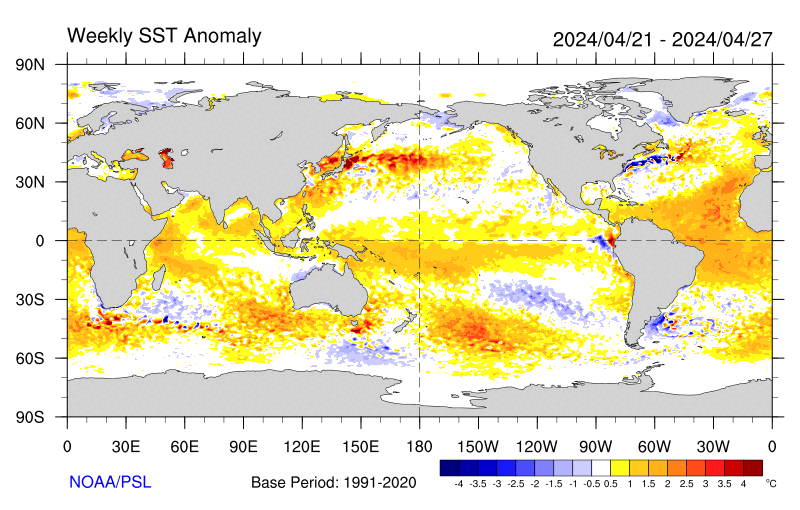
Sea-surface temperature satellite data from the National Oceanic and Atmospheric Administration mirror Jason sea-surface height measurements, clearly showing a cool Pacific Decadal Oscillation pattern, as seen at: http://www.cdc.noaa.gov/map/images/sst/sst.anom.gif.

"This multi-year Pacific Decadal Oscillation 'cool' trend can cause La Niña-like impacts around the Pacific basin," said Bill Patzert, an oceanographer and climatologist at NASA's Jet Propulsion Laboratory, Pasadena, Calif. “The present cool phase of the Pacific Decadal Oscillation will have significant implications for shifts in marine ecosystems, and for land temperature and rainfall patterns around the Pacific basin.”

According to Nathan Mantua of the Climate Impacts Group at the University of Washington, Seattle, whose research contributed to the early understanding of the Pacific Decadal Oscillation, "Even with the strong La Niña event fading in the tropics last spring, the North Pacific's sea surface temperature anomaly pattern has remained strongly negative since last fall. This cool phase will likely persist this winter and, perhaps, beyond. Historically, this situation has been associated with favorable ocean conditions for the return of U.S. west coast Coho and Chinook salmon, but it translates to low odds for abundant winter/spring precipitation in the southwest (including Southern California)."

Jason's follow-on mission, the Ocean Surface Topography Mission/Jason-2, was successfully launched this past June and will extend to two decades the continuous data record of sea surface heights begun by Topex/Poseidon in 1992. The new mission has produced excellent data, which have recently been certified for operational use. Fully calibrated and validated data for science use will be released next spring.

JPL manages the U.S. portion of the Jason-1 mission for NASA's Science Mission Directorate, Washington. JPL is managed for NASA by the California Institute of Technology in Pasadena.

For more information on NASA's ocean surface topography missions, visit http://sealevel.jpl.nasa.gov/ . To view the latest Jason-1 data, visit http://sealevel.jpl.nasa.gov/science/jason1-quick-look/ .

WEATHER NOTE

Wave surge hits PNG


A huge wave has hit a Papua New Guinea island, submerging buildings and causing widespread damage but no casualties.

The giant wave hit Kavieng, on the New Ireland province, late on Tuesday and there were reports of a similar surge hitting PNG’s north-eastern coast province of East Sepik.

Details remain sketchy but one witness told AAP the water surge hit late this afternoon and disaster teams are now working through the damage.

“The wave took out the hospital and the east coast road of New Island,” local resident Nessie Amos said.

“The hospital’s equipment was washed out but patients were saved and taken to another hospital,” she said.

“There were no casualties but major damage was caused to the hospital and everything was washed out.”

Amos said one small island off Kavieng, Tents, is mostly under water and villagers have been moved to the neighbouring island of Emirau.

Government officials held a press conference in Wewak earlier this evening.

MARITIME NOTE

Report on Collision Death off Pt. Reyes

On Dec. 10, the U.S. Coast Guard released the results of two investigations. One report outlines the causes of the July 13, 2007 fatal collision between a cargo ship and a small fishing boat which occurred in heavy fog off Pt. Reyes, and the other is an internal review of the service's handling of the incident.

The incident involved the 291 ft motor vessel Eva Danielsen, a Bahamian-flagged cargo ship, and a 28 ft wooden fishing vessel, the Buona Madre, home ported in Santa Cruz, California. A collision between the two vessels resulted in the destruction of the fishing boat and the death of Mr. Paul Wade.

A Coast Guard Marine Casualty Investigation, which was conducted by San Francisco-based investigators and reviewed and released from Coast Guard headquarters in Washington D.C., found numerous factors contributing to the cause of the collision including: failure to ensure proper manning of the respective vessels in light of the prevailing weather conditions (heavy fog); and the freighter proceeding at an unsafe speed based upon the weather conditions, failing to follow applicable Navigational Rules of the Road (i.e., fog signals), and negligence with respect to the operation of the vessel.

An internal administrative investigation was also conducted by the 11th Coast Guard District to evaluate how Coast Guard policies and procedures were followed. The internal investigation found that some internal briefing requirements and communications processes were not followed. Several recommendations of the report have been adopted to improve management of communications among Coast Guard units including: Revision of Command Center Standard Operating Procedures to include recent CG policy changes; review and revision of all Quick Response Sheets (QRS) to ensure proper notifications are made in a timely fashion; Introduction of Search and Rescue fundamentals in the Coast Guard Vessel Traffic Service (VTS) training program; and cross training among various watch positions in the Coast Guard Sector Command Center and VTS.


RS

Monday, December 29, 2008

Sub to make deep Caribbean dive

Sub to make deep Caribbean dive

Scientists are set to explore the world's deepest undersea volcanoes, which lie 6km down in the Caribbean.

Delving into uncharted waters to hunt for volcanic vents will be Autosub6000, Britain's new autonomously controlled, robot submarine.

Once found, the life, gas and sediment around the vents - the world's hottest - will be sampled and catalogued.

The research will be carried out by a British team aboard the UK's latest research ship, the James Cook.

"We are heading out on two expeditions, each close to a month long, to map the full length of the Cayman Trough," said team leader, Dr Jon Copley of the National Oceanography Centre in Southampton (NOCS).

Dr Copley explained that the Cayman Trough, which lies between Jamaica and the Cayman Islands, is a product of the Caribbean tectonic plate pulling away from the American plate.

"It is the world's deepest volcanic ridge and totally unexplored," the Southampton-based researcher told BBC News.

Along with Autosub6000, the researchers will also rely on Isis, the UK's deepest-diving, remotely operated vehicle to scan the deep.

Double Sub

First overboard will be Autosub6000, an unmanned undersea vehicle that can go down to 6,000m and carry out a dive without being controlled from the surface.

It will be tasked with finding the volcanic vents on the ocean floor.

The second submarine to take the plunge will be the Isis.

Isis will sample fluids and sediments from around the lip of the vents to test their geochemistry, and also collect animal specimens.

Map
Britain's new robot sub will map the entire length of the Cayman Trough

"We are hoping to find several different types of vents along the ridge," said Dr Copley.

"Some of the vents will be very similar in depth to the vents we already know about, and because the conditions will be alike, we might expect very similar animals," he explained.

The researchers will look to compare the animals around the Cayman vents with those in the Atlantic and Pacific, in the hope of better understanding the processes that affect how deep-sea creatures "get about".

If the organisms in the Cayman Trough look like those from other deep volcanic trenches, it will suggest that ocean currents must play a role in shaping the patterns of deep-sea life by transporting the animals' larvae around.

However, if the Cayman Trough animals are very different from those existing in other parts of the Earth's oceans then isolation will be considered more important.

"The deep ocean is our planet's largest ecosystem. If we are going to use its resources responsibly then we need understand what determines its patterns of life," the Southampton-based researcher said.

New vents

Dr Copley told BBC News that there was also another kind of venting that was driven by a very different geological process in which the Earth's mantle is directly exposed to the water.

Arm/NOCS
The researchers will explore vents looking for deep-sea animals

This type of volcanism has only ever been seen once before, in the mid-Atlantic.

The temperatures around these hydrothermal vents were so hot because they were so deep, Dr Copley said.

"They could be hotter than 500C (930F), and if they are that hot, they will probably have quite different chemistry and life forms - we expect to find new species."

The researchers expect that, at depths greater than 3,000m, one in every two animals they come across will be a species new to science.

WEATHER NOTE

Ocean observations reap climate science rewards
Long-term observations of the oceans around Australia are providing the nation’s climate scientists with significant benchmarks for seasonal forecasts and monitoring future climate change.
15 December 2008

Initiated near the end of a two-year El Niño event in May 1983, the program involves the deployment of simple ‘expendable instruments’ (XBTs) from commercial shipping that measure temperature and currents to a depth of 800m along routes in the Indian, Pacific and Southern Oceans.

“There is so much ocean around Australia influencing our daily weather and longer term climate that it made sense to begin a record from which we could connect ocean change to shifts in rainfall patterns across southern Australia,” says Dr Gary Meyers who, with colleagues at CSIRO, the Bureau of Meteorology (BoM) and the Scripps Institute of Oceanography in the US, established the ocean monitoring system.

“The 1982/83 El Niño came as a big surprise when we saw all kinds of changes around Australia but didn’t understand them. Now these ocean temperature data contribute to the BoM’s routine seasonal climate forecast.”

At 25 years the system stands as one of the longest sustained ocean observing networks in the world, and is a rare long-term record of ocean change in the huge and poorly monitored Southern Hemisphere ocean domain.

Based on the records, CSIRO’s Dr Susan Wijffels and co-authors will publish a landmark paper on the mean currents flowing between Australia and Indonesia in the Journal of Physical Oceanography. These currents form a critical ocean interconnection – the so-called Indonesian Throughflow – in the distribution of heat in the global climate system.

“Today, we have over 60,000 measurements of temperature around Australia that scientists regularly use to assess past long-term trends – test models used to predict future climate or forecast ocean behaviour,” says Dr Meyers, who leads Australia’s Integrated Marine Observing System (IMOS). “More than 50 scientific publications and books have been published using the Australian data.”

MARITIME NOTE

USCG – Marine Safety Performance

The US Coast Guard released its Marine Safety Performance Plan for FY 2009-2014.

The plan addresses the goals of: (1) reducing the risk of marine casualties; (2) facilitating commerce; (3) improving program processes and management; and (4) improving human resource capabilities. The Marine Safety Program pursues these goals through a multi-faceted approach that includes standards development; mariner credentialing; compliance enforcement; investigations and casualty analysis; industry and public outreach; and international engagement.

The Plan is a living document and may be changed in the future to reflect the results of a currently-ongoing independent evaluation of the Marine Safety mission, scheduled for completion in March 2009. Comments on the Plan are also solicited from the regulated community and other stakeholders.

(Source: Holland & Knight)


Tuesday, December 23, 2008

Ship-in-a-bottle Kit On A Microchip

Ship-in-a-bottle Kit On A Microchip

ScienceDaily (Dec. 9, 2008) Sometimes physicists resort to tried and trusted model-making tricks. Scientists at the Max Planck Institute for Metals Research, the University of Stuttgart and the Colorado School of Mines have constructed micromachines using the same trick that model makers use to get ships into a bottle where the masts and rigging of the sailing ship are not erected until it is in the bottle.

In the same way, the scientists link the valves, pumps and stirrers of a microlaboratory to create a micro device on a chip. To do this, they introduce colloidal particles - tiny magnetizable plastic spheres - as components into the channels on the chip. A rotating magnetic field is used to link the components into larger aggregates and set them into motion as micromachines.

In the future, biologists and chemists want to avoid using bulky glass flasks, Bunsen burners and magnetic stirrers as far as possible in their experiments. Similarly to microelectronics, where electrons are steered through tiny conducting paths, they intend to perform chemical reactions in microfluidic systems, that is, chambers and channels just a few micrometers in diameter. These "labs on a chip" will then allow DNA sequences or blood samples to be analyzed much more quickly and more efficiently. As they only require tiny amounts of liquids, this approach costs much less than traditional methods, which require larger quantities of materials. These micro analytical systems would also be transportable, because their core parts take up very little space. Paramedics, for example, could analyze blood samples at the site of an accident.

Researchers working with Clemens Bechinger who is a Professor at the University of Stuttgart and a Fellow at the Max Planck Institute for Metals Research, and David Marr, a professor at the Colorado School of Mines, have now found a new way to equip these miniaturized laboratories with moving parts and how to drive the tiny machines. They introduce colloidal particles, tiny plastic spheres with a diameter of just about five micrometers, into the channels and cavities on the chip.

As the particles contain iron oxide, they group together when they are magnetized by an external magnetic field. The scientists construct the magnetic field with four coils so that the microparticles are literally remote controlled and form diamond shapes or cog wheels. "The shape they assemble into depends crucially on the geometry of the channels," explains Tobias Sawetzki, who a doctoral student is working on the project. The microparticles then remain in this shape as long as the magnetic field is switched on.

The geometry also determines the function of the aggregates. By tipping backwards and forwards, a rhombus creates openings and acts like a valve. On the other hand, if it rotates in a chamber with two inflows, it mixes the incoming liquids. The micro stirrer is also driven by a magnetic field that rotates clockwise or anticlockwise parallel to the chip. In the same way, the researchers in Stuttgart roll a cog wheel through a channel with a serrated wall. The cog wheel, which completely shuts the channel off, agitates liquid back and forth and only in combination with two valves, acts like a pump.

"Compared to other approaches to equipping microlaboratories with moving parts, our ship-in-a-bottle technique has several advantages," says David Marr. Some scientists use pneumatic systems to pump liquids through microchannels, for example. However, this requires each component to be connected with a separate hose to the outside so that it can be supplied with compressed air. This is very complex and limits the integration density on microfluidic devices considerably, i.e. the total number of components on the chip.

With the new method, it is possible to accommodate up to 5,000 pumps on one square centimetre. Moreover, the new approach does not rely on elastic materials as are required for pneumatic pumps. "It is much easier to produce suitable chips for applications if they only consist of a single material, silicon, if at all possible," says Clemens Bechinger. As the electrical control components like the mini-coils can be fabricated based on silicon, it would be ideal to make the microchannels from the same material. This would allow for integration of all the components on one chip, as in microelectronics," says Bechinger.

Currently the researchers are still using large coils, so that all the components are driven by a single magnetic field and they all move in time with each other. However, this need not be a disadvantage as processes in many applications run in parallel; for example when the pharmaceutical industry searches for a new active ingredient amongst many thousands of substances. Furthermore, the researchers can choose the geometry of the channels so skilfully that different aggregates fulfil completely different functions in the same magnetic field. This means that the Stuttgart physicists’ method offers the option of driving a complex network of individual, standalone components with only one magnetic field.

WEATHER NOTE

National Weather Service recommends making preparations before the storm

Wausau Daily Herald

Now that winter is in full swing, the National Weather Service is reminding people to take precautions before a storm hits.

Items that should be kept at home and work:
• Flashlight and extra batteries.
• Battery-powered NOAA Weather Radio and commercial radio.
• Extra food and water. High energy food or food that requires no cooking is best.
• First-aid supplies.
• Emergency heating source, such as a fireplace or space heater -- make sure you have proper ventilation.

If possible, avoid driving during the storm. If you do:
• Check and winterize your vehicle before the winter season begins.
• Carry a winter storm survival kit that includes: blankets/sleeping bags, flashlight with extra batteries, first-aid kit, knife, high-calorie non-perishable food, extra clothing to keep dry, sand or cat litter, shovel, windshield scraper and brush, tool kit, and booster cables,
• Keep your gas tank near full to avoid ice in the tank and fuel lines.
• Try not to travel alone.
• Let others know your timetable and primary and alternate routes.

Where will NOAA go under the Obama Administration? OSU scientist could play a big role.


Andrew Freeman of the Washington Post blog “Capital Weather Gang” discussed potential changes at National Oceanic and Atmospheric Administration (NOAA) in his Monday, December 8th post. Why is this relevant to readers of H2ONCoast? Well, I am a Sea Grant Extension Specialist. Oregon Sea Grant’s federal mothership is NOAA, providing funds and guidance to how we do our jobs in Oregon. NOAA is not only important to the 30 Sea Grant programs around the country, but it guides research and applications to the study of climate, ocean science, fisheries, and weather among many other areas important to people living on the coast. Anyone who follows H2ONC should see that these topics are important ones to my own work and the work of many others in Oregon Sea Grant and OSU in general. Anywhere you hear words like Sea Grant, oceanography, drought, coastal zone management, coastal hazards, storms, marine fisheries, earth observation, weather or climate in the same sentence as government or research, you can bet that NOAA has something significant to do with it.

NOAA, however, is not a very “sexy” agency. It has few high-profile perks for the directors at the helm–other than rides in a hurricane hunting aircraft or first views of a new weather satellite’s output. Yet as I’ve said before, it is is immensely important to many. Here’s what Andrew Freeman had to say about the agency: Similar to the EPA and Interior Department, NOAA sits at the intersection of science and policy when it comes to numerous environmental issues — particularly climate change and oceans management.

Freeman noted that the past eight years have not been kind to NOAA or its programs: Following a turbulent eight years under President Bush, which featured allegations of political interference with NOAA scientific research, as well as cost overruns on a major environmental satellite program, the next few years are slated to be a rebuilding phase for NOAA; similar to a sports franchise that has hit a rough patch and needs an infusion of new talent and a morale boost. The question is whether the agency will come out a winner next season, or if it will struggle under new management. Much of that depends on who is selected to run the agency.

In a telephone interview on Friday, former NOAA Administrator D. James Baker, who led the agency for eight years under President Clinton, said NOAA is growing in importance due to the increasingly serious nature of environmental problems such as climate change.

Baker continued, “NOAA is the agency that monitors the pulse of the Earth and that told us that we are in danger because of climate change,” Baker said. According to him, the ideal candidate for administrator must possess a combination of scientific and political acumen, which is relatively rare. For example, both he and Conrad Lautenbacher, the most recent NOAA administrator who recently left that position, had backgrounds in oceanography among other scientific fields, as well as Washington experience.”

Baker dropped some names in play for that top slot. I’ve noted one that is a prominent OSU scientist.

  • Leon Panetta, former Democratic congressman from California, former chief of staff to President Bill Clinton and chair of the Pew Oceans Commission.
  • Former Interior Secretary Bruce Babbitt
  • Ralph Cicerone, President of the National Academy of Sciences
  • Marsha McNutt, CEO, Monterey Aquarium Research Institute
  • Jane Lubchenco, marine biologist and zoologist at Oregon State University
  • Rosina Bierbaum, Dean of the University of Michigan’s School of Natural Resources and co-director of a forthcoming World Bank report on climate change and development
  • Warren Washington, senior scientist at the National Center for Atmospheric Research
  • Michael S. Bruno, dean of the Charles V. Schaefer, Jr. School of Engineering
  • Richard Anthes, the director of the University Corporation for Atmospheric Research
  • Eileen Shea, currently the director of a NOAA center in Hawaii.

So, we will keep our eyes open on this one selection. While there are lots of important appointments and changes going on in Washington that make big news headlines, the “small ones” may count as very significant for communities as far away from the D.C. Beltway as the North Coast of Oregon. Let’s hope that this new administration’s choice of a new NOAA administrator means a new page for NOAA and its myriad locally-significant programs.

MARITIME NOTE

New maritime safety measures

By STAFF REPORTER
New measures have been drawn up which will improve safety measures for passengers travelling on Cyprus boats.

Minister of Communications and Works Nikos Nikolaides has welcomed the adoption of a new package of measures on maritime safety by the European Union Transport, Telecommunications and Energy (TTE) Council.

Speaking after the meeting, the minister said that the package strengthens the levels of vessel safety, as well as the protection of maritime environment and enhances the passengers’ rights regarding maritime transport.

“Being a country of important maritime infrastructure and know-how, [Cyprus] plays a leading role in shaping European maritime policy," he said.

"Cyprus, with its know-how and experience in the field of maritime transport, participated actively in drafting the third package of measures on maritime safety, since some of our positions, which aim at reinforcing the international maritime legislative framework and the international conventions, have been adopted."

A resolution on the European Data Center for the identification of vessels was also taken up.

Nikolaides called on the EU Commission, the European Maritime Safety Agency and EU member states to intensify their efforts for the conclusion of the European Data Center within the next six months.
(KYPE)

Ship firm calls jail term for tanker crew a 'disgrace'

SEOUL (AFP) — Managers of a Hong Kong supertanker whose crew chiefs were jailed over South Korea's worst oil spill have blasted the decision as a "disgrace and insult" to the world shipping community.

A South Korean appeal court, reversing a lower court decision, on Wednesday jailed the Indian captain Jasprit Chawla and chief officer Syam Chetan after ruling they were negligent in minimising the spillage.

The accident happened in December 2007 when a barge carrying a construction crane broke free after a cable to one of two tugs snapped in rough seas.

The barge rammed the anchored 147,000-ton tanker Hebei Spirit, holing it in three places and spilling 10,900 tons of crude oil.

V.Ships, which says it is the world's largest ship manager, said in a statement Thursday the court's decision "will surely go down as one of the most disgraceful examples of a miscarriage of justice in a 'supposedly' advanced nation state.

"For Captain Chawla and Chief Officer Chetan to be sentenced to prison terms and led from the court in handcuffs is a disgrace and insult to the whole shipping industry," it added.

The case has sparked anger among shipping operators and the International Transport Workers Federation (ITF), who insist the tanker crew were blameless.

The lower court in June had found them not guilty but prosecutors appealed the decision.

The International Association of Independent Tanker Owners has expressed "extreme dismay and disappointment" at Wednesday's ruling.

V.Ships said the ITF and its international membership are now "questioning whether it is safe for its members to travel on ships to Korea."

The lower court blamed barge operator Samsung Heavy Industries, part of the country's biggest business group, and the Korean tugboat skippers for the spill which fouled scores of marine farms and miles of beaches southwest of Seoul.

The appeal court in the central city of Daejeon agreed the Korean operators were mainly at fault and confirmed jail sentences on the tugboat skippers. But it said the tanker crew failed to take prompt action to abate the spillage.

Chawla was sentenced to 18 months in prison and fined 20 million won (14,000 dollars) while chief officer Syam Chetan was sentenced to eight months and fined 10 million won.

Their lawyers said they would appeal to the supreme court.

The ship's owner, Hong Kong-registered Hebei Ocean Shipping, was fined 30 million won.

V.Ships said the appeal court had relied on findings by the Korean Maritime Safety Tribunal (KMST ) which meant that "technically flawed, unreliable and unjust evidence" had been submitted to judges.

"In submitting their report, the KMST has demonstrated both its incompetence and an obvious desire to find fault with the officers of the Hebei Spirit," the management firm said.

"This blatant and totally unjustifiable case of criminalisation of a profession that we all rely upon for our international trade must not go unanswered by the international community and all those in the shipping industry.

CHRISTMAS AT SEA"
By Robert Louis Stevenson (1850-94).

http://www.sailorsrestcottage.com/images/christmasatsea.jpg

T
he sheets were frozen hard, and they cut the naked hand;
The decks were like a slide, where a seamen scarce could stand;
The wind was a nor'wester, blowing squally off the sea;
And cliffs and spouting breakers were the only things a-lee.

They heard the surf a-roaring before the break of day;
But 'twas only with the peep of light we saw how ill we lay.
We tumbled every hand on deck instanter, with a shout,
And we gave her the maintops'l, and stood by to go about.

All day we tacked and tacked between the South Head and the North;
All day we hauled the frozen sheets, and got no further forth;
All day as cold as charity, in bitter pain and dread,
For very life and nature we tacked from head to head.

We gave the South a wider berth, for there the tide-race roared;
But every tack we made we brought the North Head close aboard:
So's we saw the cliffs and houses, and the breakers running high,
And the coastguard in his garden, with his glass against his eye.

The frost was on the village roofs as white as ocean foam;
The good red fires were burning bright in every 'long-shore home;
The windows sparkled clear, and the chimneys volleyed out;
And I vow we sniffed the victuals as the vessel went about.

The bells upon the church were rung with a mighty jovial cheer;
For it's just that I should tell you how (of all days in the year)
This day of our adversity was blessed Christmas morn,
And the house above the coastguard's was the house where I was born.

O well I saw the pleasant room, the pleasant faces there,
My mother's silver spectacles, my father's silver hair;
And well I saw the firelight, like a flight of homely elves,
Go dancing round the china-plates that stand upon the shelves.

And well I knew the talk they had, the talk that was of me,
Of the shadow on the household and the son that went to sea;
And O the wicked fool I seemed, in every kind of way,
To be here and hauling frozen ropes on blessed Christmas Day.

They lit the high sea-light, and the dark began to fall.
"All hands to loose topgallant sails," I heard the captain call.
"By the Lord, she'll never stand it," our first mate Jackson, cried.
..."It's the one way or the other, Mr. Jackson," he replied.

She staggered to her bearings, but the sails were new and good,
And the ship smelt up to windward just as though she understood.
As the winter's day was ending, in the entry of the night,
We cleared the weary headland, and passed below the light.

And they heaved a mighty breath, every soul on board but me,
As they saw her nose again pointing handsome out to sea;
But all that I could think of, in the darkness and the cold,
Was just that I was leaving home and my folks were growing old.

2 More days til Christmas! http://library2.nalis.gov.tt/Portals/0/601/christmas%20tree.jpg
RS

Friday, December 19, 2008

NOAA Mission Discovers Historic Shipwreck Off Turks And Caicos Islands; ‘The Story Was Lost To History’

NOAA Mission Discovers Historic Shipwreck Off Turks And Caicos Islands; ‘The Story Was Lost To History’

Maritime archaeologists today announced they have recently identified the wreck of the historic slave ship Trouvadore off the coast of East Caicos in the Turks and Caicos Islands. NOAA’s Office of Ocean Exploration and Research significantly funded several years of archaeological research leading to the discovery by Don Keith and Toni Carrell, from Ships of Discovery, an underwater archaeology research institute.

The Spanish vessel Trouvadore was participating in the slave trade, outlawed in the British Indies, including the Turks and Caicos Islands. In 1841, after the vessel was grounded on a reef, Caicos authorities arrested the crew, and most of the 192 African survivors settled on Grand Turk Island.

Keith and Carrell believe the African survivors of the Trouvadore are the ancestors of a large portion of current residents in the Turks and Caicos Islands. For example, traditions on the Islands have a recognizable African origin. The Turks and Caicos National Museum is recording these traditions through oral histories and is educating the community about their ancestral history.

“What makes a people different and distinct is their unique history,” said Keith, who has worked in the islands for 30 years. “The people of the Turks and Caicos have a direct line to this dramatic, historic event – it’s how so many of them ended up being there. We hope this discovery will encourage the people of the Turks and Caicos to protect and research their local history, especially the history that remains underwater.”

“Although the sinking of the Trouvadore was a major event on the Island, the story was lost to history over the following century and a half,” said Carrell. “After we uncovered records of the shipwreck several years ago, we were stunned to realize that Turks and Caicos residents had never heard of the shipwreck that brought their ancestors to the Island.”

In 2004, using historical accounts of where the Trouvadore went down, along with remote sensing and visual searches, archaeologists focused on a ship near a local landmark known as the Black Rock. Records showed the vessel had sunk at Breezy Point, approximately two miles from the Black Rock Wreck location.

“But with the wind blowing constantly from the east, and a current running from that direction, the ship would have drifted,” Keith said. “That could have happened after it was lightened by salvage, as well.” Keith and his team used careful measurements of the hull and after years of research to amass compelling circumstantial evidence, concluded in August that the Black Rock Wreck could only be the Trouvadore.

Keith and Carrell knew from the start it would be difficult to find artifacts to identify the ship. “People of these islands traditionally have used resources from sunken ships. There are houses built on Grand Turk from ship remains,” said Keith. “We knew the ship had been salvaged upon sinking, and we weren’t going to find a bell with ‘Trouvadore 1841’ on it.”

The archaeologists learned about the Trouvadore while tracing the current locations of artifacts from the Islands that were sold to museums in the U.S. and Europe over a hundred years ago. Examining records about “African idols” that were sold, they found the account of the Trouvadore wreck.

“It’s rare and exciting to find a wreck of such importance that has been forgotten for so many years,” said Frank Cantelas, marine archaeologist for NOAA’s Office of Ocean Exploration and Research. “By identifying the Trouvadore, Don and Toni have really made a contribution to history and given the Islands’ people a better sense of place.”

Keith and his colleagues also discovered the wreck of the U.S. naval vessel Chippewa, lost in 1816. The researchers discovered a line of carronades, a unique type of cannon carried by the Chippewa, near the reef off Providenciales, which the vessel reportedly struck. The Chippewa and the Onkahye, sunk in 1848, were part of America’s efforts to stop the African slave trade and piracy by patrolling the Caribbean. Keith plans to continue work on the Chippewa wreck site and hopes to discover the Onkahye nearby.


NOAA understands and predicts changes in the Earth’s environment, from the depths of the ocean to the surface of the sun, and conserves and manages our coastal and marine resources.

WEATHER NOTE

Nenana, Alaska, Receives Nation’s 1,000th NOAA Weather Radio Transmitter

Central interior Alaskan residents, visitors, barge captains and railroad operators now have access to weather information anytime, thanks to a new NOAA Weather Radio All-Hazards transmitter recently installed on Toghotthele Hill in Nenana, the 1,000th of these transmitters installed by NOAA.

Nenana, Alaska

Residents of the Nenana area can tune to 162.4 MHz on NOAA Weather Radio for the broadcasts from NOAA’s Weather Forecast Office in Fairbanks. NOAA Weather Radio All-Hazards, known as "The Voice of the National Weather Service," is a continuous 24-hour source of the latest weather forecasts and warnings.

"Citizens can now have weather information available at their fingertips any time in the Nenana area," said John Dragomir, meteorologist in charge of the National Weather Service Weather Forecast Office in Fairbanks. "The Nenana transmitter significantly increases the weather service’s ability to reach Alaska’s central interior directly with weather warnings and forecasts. A NOAA Weather Radio in the home, car, truck, boat and other vehicles helps protect families, individuals and property."

This radio broadcast has been made possible through a partnership between NOAA, the U.S. Department of Agriculture and the city of Nenana. USDA Rural Development provided $39,438 to the City of Nenana for this project. Matching funds and in kind contributions came from the City of Nenana. USDA Rural Development has awarded 97 Weather Radio Transmitter grants for installations in 27 states and Puerto Rico since 2001.

USDA Rural Development acting Alaska state director Chad Padgett said "USDA Rural Development is pleased to partner with the National Weather Service, Nenana mayor Jason Mayrand and our great community supporters of this Program. We are pleased to administer this grant program because NOAA Weather Radio promotes public safety and awareness, and most importantly, saves lives."

"Prior to this opportunity, we had to call the weather service directly in order to receive weather warnings," said Mayrand. "Often we would hear of hazardous weather conditions through the grape vine. With the new transmitter in place not only do Nenana residents have access but also a large population of people that live in more remote regions of Interior Alaska."

"Now that the NOAA Weather Radio All-Hazards network has one thousand transmitters, we have the capability to send critical warnings and environmental information to 95 percent of the U.S. population," said Dr. John L. "Jack" Hayes, director of NOAA's National Weather Service. "NOAA Weather Radio All-Hazards alerts the public to natural or man-made disasters, and keeps them informed until the danger has passed."

MARITIME NOTE

Safety at Sea

If properly prepared, sailing off-shore can be an exhilarating and rewarding experience. Conversely, if not prepared, it can be miserable and dangerous. Because we prefer 'exhilarating and rewarding', we do everything in our power to be properly prepared. This section is meant to give the reader insight into emergency procedures aboard Vision Quest. The overall plan is to avoid emergencies, but as we all know, 'stuff' happens and you need to be ready!

Of course, the safety and well being of the crew is the highest priority. However, for emergency procedures we must put the boat first. The reason for this can be understood when you think about what would happen to the crew if there was no boat. I am primarily talking about fire and sinking.

Please keep in mind as you read this that these are general guidelines. Every situation is different and requires that the captain and crew adapt the procedures to the given situation. Also note that when a true emergency occurs, an incorrect response often leads to making a manageable situation worse.

Generally speaking, if there is a fire, or the boat is taking on water, the crew must tend to the boat first. This is a higher priority than even aiding a crew member in need. The crew must be disciplined to keep their priorities in order and think before taking action.

an example...

Lets say that you are having a nice sail with your young son or daughter (just the two of you) on a nice summer day a couple of miles offshore. Then the unthinkable happens, your child falls overboard right in front of your eyes! In the first few seconds, your instincts may tell you to jump in to save them. This is where training comes in. You take some time to think about what you need to do and realize that if you jump in after them, chances are you both will drown. You realize that the proper response is to throw floatation and execute your man over board (MOB) procedures. Because you have practiced this a number of times, you are able to bring the boat to your child and save them.

The above example demonstrates that having emergency procedures and practicing them before they are needed saves lives. This is good, but what if you were able avoid the situation altogether? These are some of the things that should have been thought about before ever leaving the dock:

  • Should I bring another experienced sailor with me in case something happens?
  • Do I have adequate lifelines?
  • Should my child be tethered to the boat?
  • Can they swim?
  • Do they have a life jacket? Are they required to where it?
  • What is the weather like? Is it going to change?
  • Do I have emergency procedures and know how to execute them?

As you can infer from this example, seamanship starts before you leave the dock. You could even say that seamanship starts before you launch your boat; even before you buy your boat!

Priorities

Priorities need to be kept very simple. The reason for this is that when the weather is rough and the crew is hungry and exhausted, complicated things are harder to remember. So, here's the top three:

  1. Don't sink
  2. Don't catch on fire
  3. Don't fall overboard

Also (not in any order):

  • Avoid bad weather
  • Know what to do if you can't avoid heavy weather
  • Watch for gear failure
  • Minimize passage time
  • Collision Avoidance
  • Keep the crew well fed and rested
  • Crew Training
  • Avoid injury
  • Avoiding Seasickness
  • Abandon Ship!

Of course there are many more things to pay attention to, in fact whole books can and have been written on all of these subjects. In the next few sections I will outline some of the things we have done aboard Vision Quest to address these concerns. This is by no means a comprehensive discussion and I will try to keep it to the points that I think people will be most interested in.

Sinking!

Vision Quest is equipped with many features to prevent taking on water. We also have specialized tools and procedures to use if we end up starting to sink.

  • Rugged companionway door with positive latch
  • Positive latches for the cockpit lockers
  • Pre-cut window repair boards that can be used to patch a blown out window. These will be mountable from inside the boat.
  • High capacity hand operated bilge pump that can be operated from the cockpit.
  • High capacity hand bilge pump that can be operated from inside the cabin with all hatches and windows shut.
  • Electric Bilge pump
  • Buckets!
  • Hull breach toolbox with materials that can be used to repair cracks in the hull.
  • Procedures for determining the source of the leak - quickly.
  • If it is obvious that the boat is going to sink and our attempts to stem the flow of water are not successful then we can begin our abandon ship procedures and take to the life raft.

Fire!

Fire prevention is the key here. All of our diesel fuel is stored in proper fuel tanks and we do not carry any fuel on deck in jerry cans. We will have a small amount of gasoline (1 gallon) for our outboard motor that we will store in a safe place (probably on one of our transom steps). Propane is properly stored in a locker designed for the purpose which vents overboard. The decks and cabin will be kept clean and orderly.

If a fire does break out, we have 4 fire extinguishers located in strategic places to fight it. The extinguisher in the galley is a fairly large one of the ABC type that can also be emptied into the engine compartment via a fire port if we have an engine fire. Procedures will be in place for the various scenarios and we will practice them.

Man Overboard!

Man overboard is more likely than fire or sinking and is an absolutely critical issue. The prevailing wisdom is that if you fall overboard you are going to die. The reason for this is that it is usually dark and stormy when this happens and it is extremely difficult to find someone in the water, let alone get the boat back to them and retrieve them. This is the case even in mild conditions and can be compounded greatly if the victim is unconscious.

Again, the best way to handle this is prevention. The crew will always be tethered to the boat when working on deck and at night. Even sitting in the cockpit during the day, crew members will have to be tied to the boat unless it is very calm and there is more than one person in the cockpit.

If someone does fall over, they will presumably have their inflatable harness on. These harnesses' inflate automatically when they hit the water and have a manual backup should the auto-inflate mechanism fail. These harnesses are also equipped with a strobe light and whistle to help the boat find them. Each crew member will practice retrieving a man overboard using the most accepted techniques in the racing community. So far, I have never seen anyone fall overboard except in sailing videos. I want to keep it that way!!

Weather Routing

It is important to pick your 'weather window' before you leave. The general consensus is that June is the best time to cross because the winter storms are over and percentage of hurricanes is very low.

Weather routing is critical. You want to avoid extreme weather situations while at the same time avoiding areas of little to no wind. These calms are good for ocean going trawlers, but not so for sailboats with a limited fuel supply. Vision Quest likes to have 15-20 knots of wind just aft of her beam and these are the conditions we will be seeking.

We use sophisticated route planning software (Max Sea) and weather chart software (Ocens Weathernet). These tools allow us to get up to date high seas analysis and forecasts for our area. We will also be using a professional weather router whom we will remain in contact with via email. This person will recommend the proper course to steer to get us into favorable weather patterns. If we lose our satellite phone and SSB radio, we will have to watch the barometric pressure, clouds, and seas to try to figure out our best course (just like the old days!). If we can raise a ship on the VHF radio, we can ask them for a forecast as well.

Heavy Weather

As discussed above, we will do everything we can to avoid heavy weather. Regardless, since we are crossing the North Atlantic and we will be out there for over 3 weeks, we will probably encounter at least a gale or two and some squalls. I would rather not get caught in a storm, but we will be prepared for that as well. Rather than get into a long discussion about tactics, I'll just summarize some of the tools and techniques at our disposal.

  • Storm Sails made of very heavy orange sail cloth
  • Inner Forestay for keeping the storm head sail closer to the center of the boat.
  • Drogue and associated tackle for keeping the boat under control while surfing down large waves ('running off').
  • Sea Anchor for riding the storm out 'bow to'.
  • 'Heave to' techniques
  • 'Crew preservation' as mentioned in the crew sections below
  • Secure, solid, and simple boat with redundant systems
  • Plenty of tools and spare parts for repairs

Gear Failure

Vision Quest has been outfitted in such a way that she can continue on her way when she loses a main system like the engine, rudder, or electrical power. We have spare sails and the ability to patch and mend them should they be damaged. We carry spare rope of all lengths and sizes and all kinds of other tools and materials to repair and patch things as they fail.

There is one thing that has no backup though and that is the standing rigging ...commonly known as the mast and boom for you land lubbers! Losing the mast would put us into a critical situation. Again, this would probably happen when it is rough out. Prevailing wisdom is that when the mast comes down, you need to cut it away and let it sink as soon as possible so that it doesn't ram into the boat and make a hole. This would be an example of one emergency causing another!

In the event that we lose the mast, we would try to build a jury rig with our spinnaker pole and anything else that we are able to salvage. This would hopefully be enough to get us to the nearest point of land. We have enough fuel to motor for 600-800 miles which will help allot but we may be more than 1000 miles away from land. Also, the nearest landfall may be unattainable due to wind and wave conditions. Depending on how much luck we have with the jury rig, amount of fuel we have, and weather conditions, we may very well have to call for help. If this is the case, we would probably be picked up by a ship and have to leave the boat behind.

The good news is that if your rig (mast) is meticulously maintained and inspected by professional riggers and constantly inspected for signs of stress, losing the rig is very unlikely. It is also important not to stress the rig too much in rough and windy conditions; this is done by reducing sail area and not 'beating' the hull too badly in head seas.

Passage Time

The chances for bad weather, gear failure, crew injury, etc go up the longer you are at sea. For this reason, one of our prime objectives is to keep the boat moving toward her destination as fast as safely possible. This is good for moral and keeps the crew busy. Basically we 'pretend' that we are in a race but we temper it with avoiding bad weather and not pushing the boat so hard that something may break. I guess what I'm saying here is that we won't be 'dilly-dallying' around!

Collision Avoidance

It is a big ocean out there, but you would be surprised how closely ships and other yachts pass by you. On Vision Quest, we consider a ship at ten miles range to be a threat and we often track them from twenty or more miles away using our radar.

We carry a radar reflector on our mast which increases the chances of the ship seeing us on their radar. We also have navigation lights on top of our mast which improves visibility at night. This is nice, but we can't depend on a busy ships crew seeing us; we need to be on the lookout for them! When we do spot a ship (or yacht) either by eye, or on the radar, we immediately begin the tracking process.

Basically what you do is watch for a changing bearing. If the bearing to the ship is gradually changing, then you will generally pass well clear of each other. If the bearing is not changing, then you are on a collision course and the ship needs to be contacted on the VHF radio while they are still a fair distance away (miles). This usually works and you mutually decide who will change course and all is well. Sometimes you can't raise them and must change course yourself.

Quick and decisive action is necessary while the ship is miles away ...it is amazing how fast they are going! If we can't get out of their way, and can't contact them, we will begin firing flares and sounding horns, which will hopefully 'snap them out of it' and get them on the radio!

Taking Care of the Crew

The goal is to have a well rested and fed crew that are happy and performing their best. The following list outlines the main things that prevent mutiny!

  • Pick well balanced, experienced people that you can get along with. Preferably people that have sailed together before.
  • Maximize sleep and relaxation time
  • Provide good food that is healthy and satisfying
  • Keep the boat clean, dry, and orderly
  • Always have dry comfortable clothing
  • Dry comfortable pillows, sheets, and blankets
  • Regular crew meetings, especially if there is any controversy or 'drama'.

Crew Training

In the case of this voyage, the selected crew all know each other and have sailed together on at least one significant passage. Before leaving and periodically during the voyage each crew member will practice many things including:

  • Man overboard recovery
  • Sinking drills (a marker is placed where the leak is and they have to find it)
  • Abandon Ship / life raft deployment drills
  • Fire fighting drills
  • Medical emergency training (at least two certified crew)
  • Sail reefing and changing drills
  • Sea anchor and drogue deployment and retrieval
  • Emergency steering
  • Emergency hull, sail, engine, and systems repair

Injury & Sickness

The best way to avoid injury is to stay well fed and rested. This way, crew members will remember to move slowly and deliberately and always have one hand available to hang onto the boat. A well fed and rested crew will also make better decisions, thus potentially avoiding an injurious situation. The other thing to keep in mind is to try and avoid severe weather and keep the boat under control. A quick story is in order.

A story: On our way to Bermuda during a celestial navigation course, we spent several days in a strong gale. There were several incidents involving losing balance and items flying across the cabin. The worst one I witnessed was a 'twofold snafu'. One night while the captain was preparing dinner, the boat lurched and a huge bottle of olive oil flew across the cabin. Luckily no one was hit, but is spilled all over the place. After a long time trying to wipe this stuff up (bad for moral) we still had an olive oil 'sheen' on the floor that we just couldn't seem to remove. The next day, one of the crew was making coffee and another lurch ...an entire can of Maxwell House all over the cabin! Now we had coffee grounds mixed into the olive oil that was left over from the night before on the floor ...a wicked mess (bad for moral).

Items in the cabin, like big bottles of olive oil, need to be secured at all times! The mess on the floor made the cabin slippery and 'icky'. Although, no one got hurt, they very well could have from the flying olive oil or slippery floor. Another less tangible result was that instead of sleeping or doing worthwhile chores, the off-watch crew had to deal with this mess for hours. Lost sleep and bad attitudes could cause a bad decision later. Again, a manageable incident being compounded into one that was less manageable. We now laugh about this and every time the olive oil comes out, so do the jokes!

Now, back to injury. We carry lots of over the counter medications and first aid supplies. We also carry prescription medications like antibiotics, seasickness medication, epi-pens, etc. We use a land based remote physician service that we can contact through email or satellite telephone. The remote doctors can guide us through the treatment and already knows what medications we have on board (they prescribed them).

Seasickness

Seasickness is a critical safety concern. Many people do recover after a day or two, but some do not. They can become dehydrated and incoherent within a matter of a few days. They are so sick that they can barely move and will definitely make poor decisions if they do decide to do something. If someone get's this sick, medical attention is often required and the remaining crew have to pick up the slack. If two crew get this sick, your ability to handle the boat will be severely compromised. When you are over 500 miles from the nearest land and out of helicopter range, the situation can become critical. You get the idea!

Like most emergencies, prevention is the key. Each crew member needs to have their own plan for dealing with seasickness. If medication is involved, they must have tried it beforehand to make sure that it doesn't cause any adverse effects. These types of medicine are designed to prevent seasickness, not cure it. Therefore, it's good practice to take it before rough weather hits.

If a crew member becomes incapacitated, we will have medications on board and access to a remote doctor over the satellite phone. This will hopefully be enough to get them recovering before the situation worsens.

Abandon Ship

I put this topic last because it is the absolutely last thing we do. In fact, the only time the boat is to be left for the liferaft is if it is almost completely underwater or engulfed in flames.

The key to abandoning ship is to have procedures in place where you simultaneously have someone making 'mayday' calls while others are launching the life raft and retrieving the abandon ship bag (grab bag).

The grab bag is critical. It contains everything needed for short term survival and rescue signaling. Without it, chances of survival are very low. With it, chances of quick rescue are very high. Therefore, the crew must know that our lives depend on that bag ...so don't forget it, don't lose it, and risk your life if you have to making sure you get it!

The links below have the procedures and grab bag contents so I won't go into that here except to say that it contains a device called a GPIRB. This device, when turned on will tell the authorities who we are and where we are and a rescue mission will begin in short order. The GPIRB is the all important key to survival (other than the raft itself of course).

As you can see, the grab bag is an all or nothing proposition. The good news is that in a dire situation where there could be panic, despair, and injury; you only have to remember one thing ...get the bag and don't lose it when getting into the liferaft!

Open Letter From INTERTANKO


Thursday, December 11th, 2008

OPEN LETTER

To President Lee Myung-bak, President of the Republic of Korea,

From INTERTANKO

We, the International Association of Independent Tanker Owners, have noted with considerable dismay the Second (Appeal) Decision of the Korean Maritime Safety Tribunal (KMST) and its findings of fault on the part of the two ship’s officers of the “Hebei Spirit”; Captain Jasprit Chawla and Chief Officer, Syam Chetan.

As a responsible and accountable international shipping association, which represents over 80% of independent tanker owner interests worldwide, we first wish to offer all our sympathy to the people of Korea who were so badly affected by the spill of oil which resulted when the runaway Samsung crane barge struck the legitimately anchored tanker “Hebei Spirit”.

We are aware that both Captain Chawla and Chief Officer Chetan were acquitted in the Daesan Court of the First Instance in June this year of all charges of criminal negligence. We are also aware that this Court Judgment is presently under appeal and understand that the Daesan Court of Appeal will be giving judgment as early as Wednesday 10 December.

We are further aware that the First (Inchon) KMST Decision has already been submitted in evidence in the Daesan Court of Appeal proceedings, and that it is likely that the Second (Appeal) KMST Decision will also be submitted in evidence in these proceedings. We are advised that Courts in Korea attach great weight to KMST Decisions. Noting this, and having considered in some detail the Second (Appeal) Decision of the KMST that is now before us as well as the First (Inchon) KMST Decision, we believe them both to be technically flawed and therefore that they draw unjust conclusions.

We wish also to express our concern that the KMST reports have not been produced in accordance with the internationally recognised IMO Interim Guidelines (MSC/Circ 1058) and IMO Code for the Investigation of Marine Casualties and Incidents. One of the cornerstones of this Code is the requirement to co-operate and consult with all interested parties before a final report is made.

We therefore urge the Daesan Court of Appeal to carefully consider all of the evidence, and in particular the judgment of the Daesan Court of First Instance, and not to rely solely on these KMST Decisions when reaching its decision. We also appeal to the Court to pay full respect to all its international treaty obligations to seafarers in rendering its decision. After it has made a careful and balanced review of all the evidence, we hope that the Court will reach a fair and just decision, not just in the interests of Captain Chawla and Chief Officer Chetan, but also as a demonstration to seafarers trading to the Republic of Korea that they can expect the highest standards of fair treatment and justice.

It would be highly regrettable if the outcome of these proceedings were to prove detrimental to Korea’s international reputation and to its status as a tanker shipping nation, to its shipyards which rely on business from international tanker owners and to its refining and chemicals industry whose oil is delivered by the international tanker fleet.

With the greatest of respect,
INTERTANKO,

8th December 2008.


Messing About In Ships Podcast


5 more days til Christmas! http://kdfblog.files.wordpress.com/2007/12/1christmas_tree.png
Have one really great weekend!


RS