skip to main | skip to sidebar

... In Search of Severe Weather

Showing posts with label large waves. Show all posts

Tuesday, December 30, 2008

Oscillation Rules as the Pacific Cools

Oscillation Rules as the Pacific Cools

PASADENA, Calif. -- The latest image of sea-surface height measurements from the U.S./French Jason-1 oceanography satellite shows the Pacific Ocean remains locked in a strong, cool phase of the Pacific Decadal Oscillation, a large, long-lived pattern of climate variability in the Pacific associated with a general cooling of Pacific waters. The image also confirms that El Niño and La Niña remain absent from the tropical Pacific.

The new image is available online at: http://www.nasa.gov/topics/earth/features/20081209.html.

The image is based on the average of 10 days of data centered on Nov. 15, 2008, compared to the long-term average of observations from 1993 through 2008. In the image, places where the Pacific sea-surface height is higher (warmer) than normal are yellow and red, and places where the sea surface is lower (cooler) than normal are blue and purple. Green shows where conditions are near normal. Sea-surface height is an indicator of the heat content of the upper ocean.

The Pacific Decadal Oscillation is a long-term fluctuation of the Pacific Ocean that waxes and wanes between cool and warm phases approximately every five to 20 years. In the present cool phase, higher-than-normal sea-surface heights caused by warm water form a horseshoe pattern that connects the north, west and southern Pacific. This is in contrast to a cool wedge of lower-than-normal sea-surface heights spreading from the Americas into the eastern equatorial Pacific. During most of the 1980s and 1990s, the Pacific was locked in the oscillation's warm phase, during which these warm and cool regions are reversed. For an explanation of the Pacific Decadal Oscillation and its present state, see: http://jisao.washington.edu/pdo/ and http://www.esr.org/pdo_index.html .

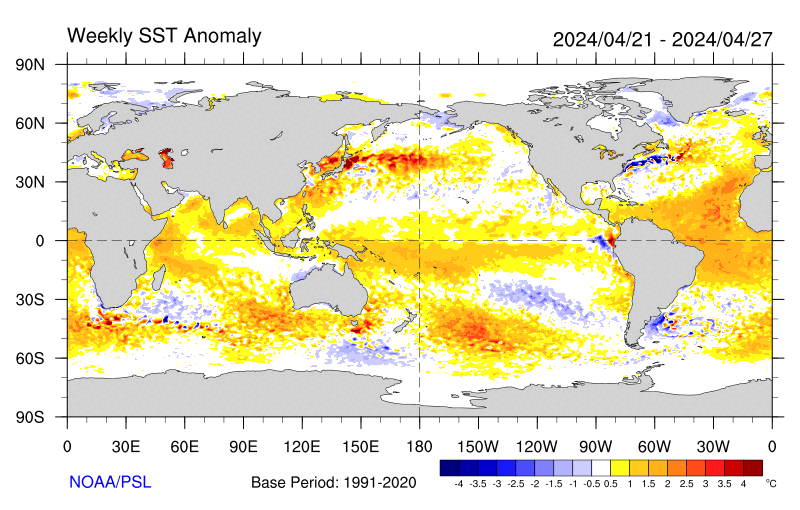
Sea-surface temperature satellite data from the National Oceanic and Atmospheric Administration mirror Jason sea-surface height measurements, clearly showing a cool Pacific Decadal Oscillation pattern, as seen at: http://www.cdc.noaa.gov/map/images/sst/sst.anom.gif.

"This multi-year Pacific Decadal Oscillation 'cool' trend can cause La Niña-like impacts around the Pacific basin," said Bill Patzert, an oceanographer and climatologist at NASA's Jet Propulsion Laboratory, Pasadena, Calif. “The present cool phase of the Pacific Decadal Oscillation will have significant implications for shifts in marine ecosystems, and for land temperature and rainfall patterns around the Pacific basin.”

According to Nathan Mantua of the Climate Impacts Group at the University of Washington, Seattle, whose research contributed to the early understanding of the Pacific Decadal Oscillation, "Even with the strong La Niña event fading in the tropics last spring, the North Pacific's sea surface temperature anomaly pattern has remained strongly negative since last fall. This cool phase will likely persist this winter and, perhaps, beyond. Historically, this situation has been associated with favorable ocean conditions for the return of U.S. west coast Coho and Chinook salmon, but it translates to low odds for abundant winter/spring precipitation in the southwest (including Southern California)."

Jason's follow-on mission, the Ocean Surface Topography Mission/Jason-2, was successfully launched this past June and will extend to two decades the continuous data record of sea surface heights begun by Topex/Poseidon in 1992. The new mission has produced excellent data, which have recently been certified for operational use. Fully calibrated and validated data for science use will be released next spring.

JPL manages the U.S. portion of the Jason-1 mission for NASA's Science Mission Directorate, Washington. JPL is managed for NASA by the California Institute of Technology in Pasadena.

For more information on NASA's ocean surface topography missions, visit http://sealevel.jpl.nasa.gov/ . To view the latest Jason-1 data, visit http://sealevel.jpl.nasa.gov/science/jason1-quick-look/ .

WEATHER NOTE

Wave surge hits PNG


A huge wave has hit a Papua New Guinea island, submerging buildings and causing widespread damage but no casualties.

The giant wave hit Kavieng, on the New Ireland province, late on Tuesday and there were reports of a similar surge hitting PNG’s north-eastern coast province of East Sepik.

Details remain sketchy but one witness told AAP the water surge hit late this afternoon and disaster teams are now working through the damage.

“The wave took out the hospital and the east coast road of New Island,” local resident Nessie Amos said.

“The hospital’s equipment was washed out but patients were saved and taken to another hospital,” she said.

“There were no casualties but major damage was caused to the hospital and everything was washed out.”

Amos said one small island off Kavieng, Tents, is mostly under water and villagers have been moved to the neighbouring island of Emirau.

Government officials held a press conference in Wewak earlier this evening.

MARITIME NOTE

Report on Collision Death off Pt. Reyes

On Dec. 10, the U.S. Coast Guard released the results of two investigations. One report outlines the causes of the July 13, 2007 fatal collision between a cargo ship and a small fishing boat which occurred in heavy fog off Pt. Reyes, and the other is an internal review of the service's handling of the incident.

The incident involved the 291 ft motor vessel Eva Danielsen, a Bahamian-flagged cargo ship, and a 28 ft wooden fishing vessel, the Buona Madre, home ported in Santa Cruz, California. A collision between the two vessels resulted in the destruction of the fishing boat and the death of Mr. Paul Wade.

A Coast Guard Marine Casualty Investigation, which was conducted by San Francisco-based investigators and reviewed and released from Coast Guard headquarters in Washington D.C., found numerous factors contributing to the cause of the collision including: failure to ensure proper manning of the respective vessels in light of the prevailing weather conditions (heavy fog); and the freighter proceeding at an unsafe speed based upon the weather conditions, failing to follow applicable Navigational Rules of the Road (i.e., fog signals), and negligence with respect to the operation of the vessel.

An internal administrative investigation was also conducted by the 11th Coast Guard District to evaluate how Coast Guard policies and procedures were followed. The internal investigation found that some internal briefing requirements and communications processes were not followed. Several recommendations of the report have been adopted to improve management of communications among Coast Guard units including: Revision of Command Center Standard Operating Procedures to include recent CG policy changes; review and revision of all Quick Response Sheets (QRS) to ensure proper notifications are made in a timely fashion; Introduction of Search and Rescue fundamentals in the Coast Guard Vessel Traffic Service (VTS) training program; and cross training among various watch positions in the Coast Guard Sector Command Center and VTS.


RS

Posted by Robin Storm - In Search of Severe Weather. at 00:01 No comments:
Labels: casualty. ships, climate change, large waves, maritime alert, maritime safety, oceans

Thursday, December 11, 2008

Climate Clues In Southern Ocean: Ocean Currents Surprisingly Resistant To Intensifying Winds

Climate Clues In Southern Ocean: Ocean Currents Surprisingly Resistant To Intensifying Winds

ScienceDaily (Dec. 2, 2008) — The Antarctic Circumpolar Current is the current system with the largest volume transport in the world ocean. Between 40° and 60°S strong westerlies move about 140 million cubic meters of water per second around the Antarctic continent (this is about five times the transport of the Gulf Stream).

Vertical motions associated with this current have been responsible for transporting a substantial fraction of the anthropogenic carbon dioxide emissions from the atmosphere to the deep ocean, thereby effectively damping the rate of global warming.

Investigations in this key region of the world ocean have been hampered by a sparse database due to the logistical challenges for ship based expeditions in the high-latitude Southern Ocean.

“In our study we used data obtained by the international Argo Programme”, explains Prof. Claus Böning from the Leibniz Institute of Marine Sciences (IFM-GEOMAR) in Kiel, Germany. Argo is a system of currently 3000 autonomous free-floating robotic systems which are surveying the world ocean. Every 10 days these buoys measure temperature and salinity profiles over the upper 2000 meters. These measurements are transmitted to land stations via satellite. “For this study about 52,000 profiles of more than 600 Argo-drifters in the Southern Ocean were used and compared with historic ship measurements”, explains oceanographer Astrid Dispert from IFM-GEOMAR. For this analysis the extensive archives of the Australian marine research centre in Hobart, Tasmania were also used.

As expected, the observations in the subpolar ocean demonstrate an increase of water temperature and a decrease in salinity at the same time. Nevertheless, in contradiction to the simulations of various climate models the data show no significant changes in water transport. “Our results point to one important thing: Eddies which are currently not resolved in climate models might be the key process in controlling the transport of the ACC”, Prof. Böning explains. Hence, his conclusion is that investigations with high-resolution ocean models are required to test this hypothesis. “Of course, besides the simulations we also need further observations”, adds Prof. Martin Visbeck (IFM-GEOMAR). “Thanks to the international Argo observations programme we now have continuously access to data from a worldwide network of more than 3000 profiling-drifters. This is a quantum leap in the field of ocean observations, which, together with high resolution modelling gives us new insights about long-term changes in the ocean.“

Further investigations have to show whether the results are robust. If confirmed, this would in one way be good news: Until now the Southern Ocean is the biggest oceanic sink for anthropogenic carbon dioxide and therefore a crucial regulator for the atmospheric carbon dioxide concentration. Climate models predicted a severe reduction in the southern ocean carbon dioxide uptake due to wind-forced changes in the current fields. Now high-resolution models are needed to assess the role of the hitherto unresolved ocean eddies in the Southern Ocean’s response to the progressive changes in the atmospheric conditions.

WEATHER NOTE

Venice under water

Duckboards and elevated walkways were set up throughout Venice today and elderly residents were carried to dry ground, as the city faced its worst flooding for two decades.

Venice

A woman wakls on Piazza San Marco yesterday. Nearly all the streets of the city were underwater. Pic: AFP

As sirens blared throughout the city, the Mayor Massimo Cacciari asked prospective tourists to not to visit - and advised those already there not to move around unless it was "unavoidable" because of the "exceptional" situation. "Anyone thinking of coming to Venice should think again," he said.

As the sea surged into St Mark's Square, arguably Venice's most famous landmark, it became completely submerged under eighty centimetres of water. In total, more than 95% of the rest of central Venice was flooded and some pontoon bridges began floating away in the rising tide, leaving residents stranded in their homes.

Driven by strong winds and heavy rain, the water rose to 156cm above sea level - the highest "acqua alta" since 158cm in 1986. Sirens sounded as the Venice tide monitoring centre warned that the water could rise to over 160 centimetres for the first time in thirty years.

The worst floods took place in 1966 when the waters reached a record 194 centimetres above sea level, causing devastation to homes, shops and historic monuments and art works. Flooding of 100-130cm above sea level is common in the lagoon city in autumn and winter.

As today's floods intensified, workers set up duckboards and elevated walkways as the sirens sounded, and text messages with warnings and updates were sent to those who have registered with the flood warning centre on their mobile phones. Elderly residents were carried to dry ground, and homes and shops activated their ground floor pumps.

The plight of Venetians and visitors was compounded by a national transport strike which affected the Venice "vaporetto" or water bus service.

Giancarlo Galan, head of the Veneto region, said the transport workers had chosen a bad time to strike. "I'd like to give them a medal for their sense of responsibility," Mr Galan said sarcastically.

A floating flood barrier is under construction at three entrances from the Adriatic into the lagoon, but is not due to go into operation until 2012 at the earliest. The authorities are also considering a scheme to raise the city's buildings by up to a metre using piston-supported-poles.

The growing severity and frequency of floods is attributed to silt deposits raising the floor of the lagoon and a rise in sea levels caused by global warming.

However Mr Cacciari played down alarm, saying flooding was part of everyday life in Venice. "We get sea levels of 140m, 160m every few years," the Mayor said. Italian meteorologists said the entire country was being affected by bad weather, with driving rain, snow, hail and high winds causing flooding "from the Alps to Palermo".

Many roads in Piedmont, Liguria and Lombardy were closed, and Rome was hit by hail and rainstorms, with fallen trees blocking roads and cars submerged in flooded road tunnels.

Researchers Use Sun Cycle to Predict Rainfall Fluctuations


(PhysOrg.com) -- The sun’s magnetic field may have a significant impact on weather and climatic parameters in Australia and other countries in the northern and southern hemispheres.

ccording to a study in Geographical Research published by Wiley-Blackwell, the droughts in eastern Australia are related to the solar magnetic phases and not the greenhouse effect.

The study titled “Exploratory Analysis of Similarities in Solar Cycle Magnetic Phases with Southern Oscillation Index Fluctuation in Eastern Australia” uses data from 1876 to the present to examine the correlation between solar cycles and the extreme rainfall in Australia.

It finds that the Southern Oscillation Index (SOI) – the basic tool for forecasting variations in global and oceanic patterns – and rainfall fluctuations recorded over the last decade are similar to those in 1914 -1924.

Author Professor Robert G. V. Baker from the School of Environmental Studies, University of New England, Australia, says, “The interaction between the directionality in the Sun’s and Earth’s magnetic fields, the incidence of ultraviolet radiation over the tropical Pacific, and changes in sea surface temperatures with cloud cover, could contribute to an explanation of substantial changes in the SOI from solar cycle fluctuations. If solar cycles continue to show relational values to climate patterns, there is the potential for more accurate forecasting through to 2010 and possibly beyond.”

The SOI-solar association has been investigated recently due to increasing interest in the relationship between the sun’s cycles and the climate. The solar application offers the potential for the long-range prediction of SOI behavior and associated rainfall variations, since quasi-periodicity in solar activity results in an expected cycle of situations and phases that are not random events.

Professor Baker adds, “This discovery could substantially advance forecasting from months to decades. It should result in much better long-term management of agricultural production and water resources, in areas where rainfall is correlated to SOI and El Niño (ENSO) events.”

This paper is published in the December 2008 issue of Geographical Research Vol. 46 Issue 4. (Report)


MARITIME NOTE

Science Speaks: Rogue Waves are Real
'Rogue wave approaching on ship Nathaniel B Palmer' .
Every year sound sailing boats, well equipped with safety gear, with experienced crew on board, go missing. Their loved ones are forever left wondering: Was it a whale? a floating container? a rogue wave?

In the past, some scientists wrote off 'rogue waves' as rare or even mythology.


Rogue waves on NOAA ship Discoverer in the Bering Sea - .. .
However, satellite data collected by the European Space Agency's (ESA) ERS satellites has confirmed what too many ship captains have come to know (and occasionally captured photographs). Ocean waves that rise as tall as ten-story apartment buildings are a leading cause of large ship sinkings.

The Norwegian Dawn, a 965-foot ocean liner , was sailing back to New York from the Bahamas on April 16 2005 when it was struck by a rogue 70-foot wave. The wave smashed windows and sent furniture flying, but the ship survived and the crew lived to record the wave's arrival.

A sailing boat faced with such a wave would have little chance of survival, and if it came at night, maybe not even the chance to hit the EPIRB.

A giant wave can form when strong winds beat against an opposing ocean current, when waves from different storms join forces, or when swells interact in strange ways with a particular seafloor.

Wave Height Predictions off the coast of Massachusetts - .. . Click Here to view large photo
Since 2005, Vijay Panchang at the A&M University at Galveston in Texas and his associates say they can accurately predict the daily height of waves anywhere off the coast of the United States for the next 48 hours across spaces as close as 500 yards apart.

A buoy off the coast of Alabama recently recorded an average wave height of 16 meters before the gauge broke, Panchang said. Since that figure is just an average of measurement of a sea-state, the biggest wave at that location was probably twice that size--32 meters, or about 100 feet.

'There were oil platforms destroyed,' said Panchang, who requires his wave mechanics students to read The Perfect Storm. 'The sheer magnitude of these things amazes me.'

Severe weather has sunk more than 200 supertankers and container ships more than 200 yards long in the past two decades, an ESA analysis found.

Counting waves from space:

The two ERS satellites equipped with radar carry out a global rogue wave census and arrive at the truth.

Without aerial, cloud-penetrating radar, scientists could only go on radar data on waves collected from oil platforms.

The radar instruments on the satellites detected the height of individual waves at the surface in 3-mile by 6-mile patches of the sea. Three weeks of data, including 30,000 of these patches or 'imagettes' of the sea with their wave height information were analyzed and searched for extreme waves at the German Aerospace Center.

A scientific team counted more than ten individual giant waves around the globe more than 75 feet high during the three-week period.

What can the cruising sailor do?
Rogue wave approaching in the Bay of Biscay Fall 1993 - NOAA - .. .
There are a few things that long range cruisers can do when setting off, apart from the obvious ones like never travelling close to a cyclone season, taking particular note of existing currents, and watching the weather like your life depends on it - because it does.

If there are different swells meeting, the other most obvious rule is to stay away from underwater mountains and ranges, where rogue waves are likely to develop if other conditions accumulate. There are many examples of underwater disturbances on the world's charts, eg. between Madeira and the Canary Islands, between Sydney and Lord Howe Island, and between Palmerston Atoll and Tonga.

Another underwater feature to be avoided is the underwater cliff, which often occurs close to coastlines. One of the most notorious of these is in the Bay of Biscay, where the depth changes from thousands of meters to a few hundred in a short distance.

To find examples of Vijay Panchang's wave predictions, which do not exist for all parts of the world, click here


RS
Posted by Robin Storm - In Search of Severe Weather. at 00:25 No comments:
Labels: coastal flooding, floods, large waves, oceanography, rogue waves, severe weather

Tuesday, December 9, 2008

National Weather Service in Norman gauges readiness

National Weather Service in Norman gauges readiness

NORMAN — There were no black clouds rolling in from the southwest. No lightning strikes. No hail denting car hoods.

So why were all the emergency management vehicles in the parking lot of the National Weather Center on Tuesday?

Because more than 100 emergency managers, media, National Weather Service and other National Oceanic and Atmospheric Administration personnel are preparing for the days the clouds, the lightning, the hail and possibly much more bully their way into Oklahoma.

Tuesday marked the opening day of the National Weather Service’s three-day "Next Generation Warning Services Workshop.”

"The idea is to make our warning services for hazardous weather better,” said Kevin Scharfenberg, the weather service’s severe storm services coordinator.

Tom Merrill is the Emergency Manager for Cordell in Washita County. He said the weather service is receptive to making changes to fit the needs of the end-users — emergency management and the citizens they protect.

Merrill said in January the Weather Service starts going to communities to train storm spotters. In March, a severe weather workshop is held.

"That prepares everyone for the storm season,” he said. "Plus, it’s great to be sitting in Cordell talking on a ham radio during severe weather and know who you are talking to at the National Weather Service. You have a feel for what he’s wanting.”

He praised the OK

FIRST program through the Oklahoma Climatological Survey that prepares personnel for severe weather.

Lloyd Colston also is attending this week’s "Next Generation Warning Services Workshop.” Colston is the director of emergency management for the city of Altus in Jackson County.

"We live in an age when the sirens are not enough,” Colston said.

In the last two months, Colston has set up AltusEm.Blogspot.com and Twitter.com/AltusEm.

WEATHER NOTE

Rogue wave drowns 3 people

2 others survive Mugu Rock waters

By Cheri Carlson
Originally published 10:54 p.m., November 27, 2008
Updated 10:11 a.m., November 28, 2008

Three young Oxnard men died Thursday after being swept off a rocky ledge and into the ocean near Point Mugu.

Shortly before 2 p.m., a wave knocked five people into the water beneath Mugu Rock, according to witnesses. The two survivors, a 17-year-old and a 27-year-old, made it to the shore and started calling for help, said Ventura County Sheriff's Sgt. Steve Sagely.

Three others were later pulled out of the water. All three were pronounced dead at the scene, Sagely said. On Friday, the Ventura County Medical Examiner's Office identified two of the dead as brothers, Catalino Ramos Vasquez, 19, and Marcelo Ramos Vasquez, 17. The other victim was identified as Pedro Avila Ramos. His age was not immediately known.

A woman at the popular ocean lookout responded to the calls for help before rescue crews arrived, jumping into the water and pulling one of the three victims onto shore, according to witnesses.

Sagely identified her as 24-year-old Kathryn Barrona of Camarillo. He called her actions heroic. She could not be reached for comment.

The two other men were pulled from the water by emergency responders, including rescue swimmers and a helicopter crew, by 2:30 p.m.

The victims' names were not released, pending notification of family members. It was unclear if they all were related.

Ana Savedra of Canyon Country was reading in her car parked on the turnout at Mugu Rock and watched as the five headed down the rocky hill closer to the water.

"They seemed like they were having fun," she said. Later, however, Savedra saw people running around, calling for help. Rescue crews and a helicopter came quickly, she said.

Previous drownings have been reported in the same area, including a 16-year-old boy who was swept into the water while fishing off a cliff below Mugu Rock in January.

For the past two years, Savedra has been going to the same spot to relax.

"It's a beautiful place," she said, but she's never gone down the hill where the tide crashes up against the rocky shoreline. "It's very dangerous."

MARITIME NOTE

Russian Register of Shipping - Guarantee for quality and safety

Russian Maritime Register of Shipping (RS) has been awarded a golden medal ‘Guarantee for quality and safety’. RS has become a laureate of National Safety awards and has received a golden medal in the nomination “For the development of technical standards aimed at ensuring safety of offshore oil and gas facilities”. The National Safety awards were held during the “Russian Industrial Exhibition – 2008”. More than 300 Russian and foreign companies participated in the event.

As a participant RS has submitted its Rules for the Classification, Construction and Equipment of Mobile Offshore Drilling Units (MODU) and Fixed Offshore Platforms (FOP). The Rules are based on the scientific research carried out by the leading scientific organizations of Russia (in total over 40 research works).

The Rules are systematically being improved and in the 2008 the third edition was published. The new edition is based upon the IMO and IACS recommendations and the latest research results as regards the advanced study of the external loads on the FOP hull structure, incorporating the requirements to the TLP and Spar installations in the Rules, further improvement of the formal safety assessment of MODU and FOP, continuous monitoring of the FOP subject to the heavy ice loads.

RS allocates considerable resources to perform scientific research aimed at enhancing safety and environment protection standards.

The requirements of the RS rules aimed at minimising the mankind impact on the marine environment are based upon scientifically based risk assessment and risk management procedures.

Source: Russian Maritime Register of Shipping

Mich. law restricting ballast dumping is upheld


A federal appeals court has upheld a Michigan law designed to prevent oceangoing freight ships from bringing invasive species to the Great Lakes.

The 6th U.S. Circuit Court of Appeals on Friday rejected a challenge to the law filed by shipping organizations.

The 2005 law requires saltwater ships calling at Michigan ports to get a permit from the state Department of Environmental Quality.

The permit certifies that the ship will not discharge ballast water in port or has technology to kill any live organisms in the water before it's dumped.

More than 180 invasive species are in the Great Lakes. Many of them are believed to have arrived in ship ballast.


RS
Posted by Robin Storm - In Search of Severe Weather. at 00:36 No comments:
Labels: large waves, maritime safety, national weather service, noaa, rogue waves, severe weather

Thursday, December 4, 2008

Missing radioactivity in ice cores bodes ill for part of Asia

Missing radioactivity in ice cores bodes ill for part of Asia

When Ohio State glaciologists failed to find the expected radioactive signals in the latest core they drilled from a Himalayan ice field, they knew it meant trouble for their research.

But those missing markers of radiation, remnants from atomic bomb tests a half-century ago, foretell much greater threat to the half-billion or more people living downstream of that vast mountain range.

It may mean that future water supplies could fall far short of what's needed to keep that population alive.

In a paper just published in Geophysical Research Letters, researchers from the Byrd Polar Research Center explain that levels of tritium, beta radioactivity emitters like strontium and cesium, and an isotope of chlorine are absent in all three cores taken from the Naimona'nyi glacier 19,849 feet (6,050 meters) high on the southern margin of the Tibetan Plateau.

"We've drilled 13 cores over the years from these high-mountain regions and found these signals in all but one - this one," explained Lonnie Thompson, University Distinguished Professor of Earth Sciences at Ohio State.

The absence of radioactive signals in the top portion of these cores is a critical problem for determining the age of the ice in the cores. The signals, remnants of the 1962-63 Soviet Arctic nuclear blasts and the 1952-58 nuclear tests in the South Pacific, provide well-dated benchmarks to calibrate the core time scales.

"We rely on these time markers to date the upper part of the ice cores and without them, extracting the climate history they preserve becomes more challenging," Thompson said.

"We drilled three cores through the ice to bedrock at Naimona'nyi in 2006," said Natalie Kehrwald, a doctoral student at Ohio State and lead author on the paper. "When we analyzed the top 50 feet (15 meters) of each core, we found that the beta radioactivity signal was barely above normal background levels."

Tritium, an isotope of hydrogen, and chlorine-36 were also both absent from the Naimona'nyi cores, she said. They were able, however, to find a small amount of a lead isotope, lead-210, which allowed them to date the top of the core.

"We were able to get a date of approximately 1944 A.D.," Kehrwald said, "and that, coupled with the other missing signals, means that no new ice has accumulated on the surface of the glacier since 1944," nearly a decade before the atomic tests.

While the loss of the radioactive horizons to calibrate the cores poses a challenge for Thompson's research, he worries more about the possibility that other high-altitude glaciers in the region, like Naimona'nyi, are no longer accumulating ice and the impact that could have on water resources for the people living in these regions.

"When you think about the millions of people over there who depend on the water locked in that ice, if they don't have it available in the future, that will be a serious problem," he said.

Seasonal runoff from glaciers like Naimona'nyi feeds the Indus, the Ganges and the Brahmaputra rivers in that part of the Asian subcontinent. In some places, for some months each year, those rivers are severely depleted now, the researchers said. The absence of new ice accumulating on the glaciers will only worsen that problem.

"The current models that predict river flow in the region have taken recent glacial 'retreat' into account," said Kehrwald, "but they haven't considered that some of these glaciers are actually thinning until now.

"If the thinning isn't included, then whatever strategies people adopt in their efforts to adapt to reductions in river flow simply won't work."

Thompson fears that what's happening to the Naimona'nyi glacier may be happening to many other high-altitude glaciers around the world. "I think that this has tremendous implications for future water supplies in the Andes, as well as the Himalayas, and for people living in those regions."

The absence of the radioactive signals in the 2006 Naimona'nyi core also suggests that Thompson and his colleagues have been lucky with their previous expeditions to other ice fields.

"We have to wonder -- if we were to go back to previous drill sites, some drilled in the 1980s, and retrieved new cores -- would these radioactive signals be present today?" he asked.

"My guess is that they would be missing." The researchers' recent work has shown similar thinning on glaciers in Africa, South America and in Asia in the past few years.

WEATHER NOTE

Maritimes didn't escape hurricanes this year

The Maritime provinces were hit with the remnants from various tropical storms and hurricanes this year, even though there was a less than normal number of named storms moving up the Atlantic Coast in 2008.

In some cases, the effect was no more than light rain, but in others, it was heavy rainfall fanned by gale-force winds.

It was the remnants from hurricanes Hanna and Kyle, both of which occurred in September, that brought the most severe weather conditions for New Brunswick, said Alex Sosnowski of State College. Pa., a spokesman for the AccuWeather.com Hurricane Centre.

Sosnowski said not all of the tropical storms moved into the province from the Atlantic Coast. He said some of them made their way inland, were re-energized by the Great Lakes and then, proceeded to head eastward, entering New Brunswick from the west.

The hurricane season officially runs from June 1 to the end of November, although you can sometimes get them later, such as occurred in 2005.

To be designated a name, a disturbance has to make it at least to tropical storm status. A tropical storm represents the level of severity immediately below that of a hurricane.

Sosnowski said hurricanes are rated in terms of intensity from Category 1 to Category 5 on the five-step Saffir-Simpson scale. Any of them ranking between Category 3 and 5 are considered to be major hurricanes with tremendous destructive capacity, he said.

Last year, he said there were 15 named storms, six of which reached hurricane status.

In the spring of this year, Sosnowski said the team of hurricane experts at Colorado State University predicted that there would also be 15 named storms this year, but that eight of them would graduate to hurricane status.

And they appear to have hit the nail just about on the head, said the AccuWeather.com meteorologist. To this point, he said there have been 16 named storms, eight of which became hurricanes.

Sosnowski said the last tropical storm this year was Paloma, which was a Category 4 hurricane. He said it strengthened rapidly and slammed into Cuba a few weeks ago, causing significant damage in much of that country.

The strength of high pressure over the Atlantic this year "pushed everything to the left," he said. As a result, he added, a lot of named storms ended up swinging into the Gulf of Mexico or south toward Central America.

Sosnowski anticipated there was little chance of another tropical storm developing the rest of this year.

This time of the year, he explained, there are significant wind shears that rip the tops off tropical disturbances before they can get a chance to develop into a storm or hurricane.

MARITIME NOTE

Rogue Waves: They're Real, & They're Spectacular

I recently learned I might serve this spring as a subject expert aboard a cruise ship crossing the Atlantic, as part of an "enrichment program" that provides passengers the opportunity to interact with experts in various fields. I've been identified as an individual who will address "Everything You Wanted to Know about the Weather, Sea and Sky - and Then Some!"

Sounds great. My only real concern was whether I might get sea sick, having never been on an ocean cruise. But then I began thinking about a recent presentation (ppt) on "rouge waves" given by Linwood Vincent, of the U.S. Office of Naval Research, at a meeting of the DC Chapter of the American Meteorological Society. As I thought about Vincent's nightmarish stories and pictures, I worried that sea sickness could be the least of my problems, even if the odds of encountering a rogue wave are extremely small.

Keep reading for more on these monstrous waves...

Technically, rogue waves, sometimes referred to as "freak waves," are defined as waves whose height from wave crest (highest point) to wave trough (lowest point) is more than twice the average height of the largest one-third of waves in a set of measured waves. More simply, as Vincent explained, they are essentially "big waves relative to what you expect to be there."

As described nicely by an article in the New York Times, the two most likely explanations for the occurrence of rogue waves are when smaller waves merge to form large waves, and when storm-generated waves crash into ocean currents coming from the opposite direction.

Vincent cites the example of an oil platform in the North Sea that was experiencing rough but reasonable waves of 13 to 26 feet during a storm on New Year's Day, 1995. Suddenly, seemingly out of nowhere, the platform was hit and extensively damaged by a monstrous wave that instruments measured at more than 80 feet in height (the so-called "Draupner Wave").

Want to go even bigger? In February 2000, scientific instruments onboard a British research west of Scotland measured waves up to 95 feet. More recent (but perhaps somewhat less reliable) observations have recorded wave heights up to 110 feet, about the same height as the Statue of Liberty. Just as important as height is that rogue waves are usually extremely steep. Plowing into one is like hitting a nearly vertical wall of water. If a vessel is lucky enough to survive the initial impact, then coming over the crest is like riding down the steepest incline of the world's tallest roller coaster.

And, by the way, I've never been so scared as my first ride on a roller coaster not too many years ago -- and have not been on one since.

For centuries, these enormous waves had been dismissed as myths. But scientists now recognize these giant wallops of water are far more common and destructive than once imagined. According to Vincent, freak waves are suspected of sinking at least dozens of large ships, including supertankers, while taking hundreds of lives. Freak waves are known to occur in the Great Lakes as well as the oceans. It is believed that just such a wave contributed to the sinking of the freighter SS Edmund_Fitzgerald in May 1975 on Lake Superior. All 29 hands perished in this most famous of Great Lakes disasters.

Cruise liners, at least in recent times, have been more lucky -- if you can call it that -- in their close encounters with rogue waves. In February 1995, the Queen Elizabeth II was slammed by a 95-foot-high wave in the North Atlantic. Captain Ronald Warwick described it as "a great wall of water... it looked as if we were going into the White Cliffs of Dover." But the ship survived with some passengers suffering relatively minor injuries. In April 2005 off the coast of Georgia, the Norwegian Dawn, a 965-foot ocean liner, was struck by a rogue wave estimated at 70 feet high. The wave smashed windows, sent furniture flying, injured four passengers and, not surprisingly, instilled widespread fear and panic.

And the accounts above are only a sampling of the many that have been reported. For example, see: here and here.

The only video of an actual encounter with a rogue wave I'm aware of is the amazing encounter of a 100-foot fishing boat, which was shot for the Discovery Channel's program, "The Deadliest Catch."

As for that gig on the cruise ship, I'll take the advice of my 4-year-old granddaughter: "Don't be scared, Pop-Pop. I didn't get scared when we went sledding last year down the big hill." How could I not go after that kind pep talk? And besides, running into a rogue wave is even less likely than being swept up by a tornado or hit by lightning. But I'll be sure to pack the sea-sickness pills, and probably not mention rogue waves to the passengers.

French join Canadians in Atlantic search of French crew

HALIFAX - A French naval reserve vessel has joined Canadian crews searching for survivors of a French-owned vessel that capsized and sank near the south coast of Newfoundland on Tuesday.

There were four people on board the 30-metre Cap Blanc when it went down about 16 kilometres south of Marystown, N.L. on the Burin Peninsula.

But officials said Wednesday the chance of finding survivors was growing slim. It's not known whether the crew were wearing survival suits.

Meanwhile, another rescue centre spokeswoman denied a French media report that Canadian divers had heard noises inside the vessel before it sank in about 100 metres of water at 2 p.m. local time.

Jeri Grychowski said there was no truth to the report.

The vessel was reported overdue Tuesday after departing Argentia, N.L. for the 12-hour voyage to its home port on the French islands of St-Pierre-Miquelon, off Newfoundland's south coast.

Searchers have found an empty life-raft and a life preserver, but no sign of survivors or other wreckage on the surface. The Cap Blanc was known to have carried two life-rafts.

On Wednesday, a Cormorant helicopter from Gander, N.L. continued the search, along with two coast guard vessels and the French naval ship, Fulmar.

St-Pierre is 20 kilometres off the southern tip of the Burin Peninsula, and the drama unfolding nearby is riveting many on the island of 6,500.

Finding the boat overturned in the water delivered a strong blow to the community, wrote St-Pierre magazine Mathurin on its website.

"There is an immense sadness, of a kind felt by ocean communities struck to the heart by an implacable sea," wrote author Henri Lafitte. "The wait continues until the limits of hope."


RS

Posted by Robin Storm - In Search of Severe Weather. at 00:21 No comments:
Labels: climate change, hurricanes, large waves, marine weather, Rouge Waves, severe weather

Monday, December 1, 2008

Scientists find evidence of tsunamis on Indian Ocean shores long before 2004

Scientists find evidence of tsunamis on Indian Ocean shores long before 2004

A quarter-million people were killed when a tsunami inundated Indian Ocean coastlines the day after Christmas in 2004. Now scientists have found evidence that the event was not a first-time occurrence.

A team working on Phra Thong, a barrier island along the hard-hit west coast of Thailand, unearthed evidence of at least three previous major tsunamis in the preceding 2,800 years, the most recent from about 550 to 700 years ago. That team, led by Kruawun Jankaew of Chulalongkorn University in Thailand, included Brian Atwater, a University of Washington affiliate professor of Earth and space sciences and a U.S. Geological Survey geologist.

A second team found similar evidence of previous tsunamis during the last 1,200 years in Aceh, a province at the northern tip of the Indonesian island of Sumatra where more than half the deaths from the 2004 tsunami occurred.

Findings from both teams are published in the Oct. 30 edition of Nature.

Sparse knowledge of the region's tsunami history contributed to the loss of life in 2004, the scientists believe. Few people living along the coasts knew to heed the natural tsunami warnings, such as the strong shaking felt in Aceh and the rapid retreat of ocean water from the shoreline that was observed in Thailand.

But on an island just off the coast of Aceh most people safely fled to higher ground in 2004 because the island's oral history includes information about a devastating tsunami in 1907.

"A region's tsunami history can serve as a long-term warning system," Atwater said.

The research will reinforce the importance of tsunami education as an essential part of early warning, said Jankaew, the lead author.

"Many people in Southeast Asia, especially in Thailand, believe, or would like to believe, that it will never happen again," Jankaew said. "This will be a big step towards mitigating the losses from future tsunami events."

The team found evidence for previous tsunamis by digging pits and auguring holes at more than 150 sites on an island about 75 miles north of Phuket, a Thai tourist resort area ravaged by the 2004 tsunami. That tsunami was generated 300 miles to the west when the seafloor was warped during a magnitude 9.2 earthquake.

At 20 sites in marshes, the researchers found layers of white sand about 4 inches thick alternating with layers of black peaty soil. Witnesses confirmed that the top sand layer, just below the surface, was laid down by the 2004 tsunami, which ran 20 to 30 feet deep across much of the island.

Radiocarbon dating of bark fragments in soil below the second sand layer led the scientists to estimate that the most recent predecessor to the 2004 tsunami probably occurred between A.D. 1300 and 1450. They also noted signs of two earlier tsunamis during the last 2,500 to 2,800 years.

There are no known written records describing an Indian Ocean tsunami between A.D. 1300 and 1450, including the accounts of noted Islamic traveler Ibn Battuta and records of the great Ming Dynasty armadas of China, both of which visited the area at different times during that period. Atwater hopes the new geologic evidence might prompt historians to check other Asian documents from that era.

"This research demonstrates that tsunami geology, both recent and past tsunamis, can help extend the tsunami catalogues far beyond historical records," Jankaew said.

The new findings also carry lessons for the northwest coast of North America, where scientists estimate that many centuries typically elapse between catastrophic tsunamis generated by the Cascadia subduction zone.

"Like Aceh, Cascadia has a history of tsunamis that are both infrequent and catastrophic, and that originate during earthquakes that provide a natural tsunami warning," Atwater said. "This history calls for sustained efforts in tsunami education."

WEATHER NOTE

FROM NWS CHICAGO

River Ice Spotters Wanted

The National Weather Service (NWS) in Chicago/Romeoville, IL is looking for individuals that live or work along rivers to become part of our river ice spotter network. The river ice spotter network was created last year and was a great success. It consisted of ice spotters living primarily along the Kankakee River that provided valuable data on ice cover and ice jam flooding to our office. We would like to expand our network this season to include ice spotters along other rivers in northern Illinois including the Fox and Rock rivers.

Kankakee River Ice Jam January 2008Ice jams can result in rapid and devastating flooding. Although the NWS does monitor automated river gages, they typically do not accurately reflect the current conditions upstream and downstream due to the isolated nature of ice jams. It is also important to know the extent of the current ice cover and other conditions. That kind of information can only be obtained from visual observations. Under no circumstances are river ice spotters to actually go out on the ice! Your safety is important to us. Observations should be made from a safe location only.

River ice spotters will receive basic training that will cover ice formation and ice reporting procedures.

If you are interested please contact Bill Morris, Hydrologist at the National Weather Service Chicago/Romeoville office. Please include your name, address, phone number, and email.

Thank you!

MARITIME NOTE

Maritime Transportation And Shipping Talk

Maritime Transportation In North Atlantic - Winter Time

http://www.marine.tmd.go.th/images/bforce12.jpg

North Atlantic Ocean can be an unforgiving place to be in the winter. Any seafarer that works in this area knows that firsthand. More than likely they have seen how ruffs this area can be. Nerves are stretched and senses are on high alert. Leaving port, a last check on all lashing, weather-doors and hatches. Forecast looks ok at the moment but things can change in a hurry up here in the North Atlantic wintertime.

Modern equipment for weather and navigation has made things easier for preparation but it should not make you complacent. I guess that a few hours of steaming should be enough time to see if all is ok with cargo lashings etc. Making rounds and verifying lashings and other security is routine on most cargo ships but the North Atlantic makes for heightened security inspections and attention to details become more important than ever. Your life might just depend on it. Stress on ship and men are extreme this time of the year.

So what are some of the factors involved?


From a safety point of view onboard the ship, nothing should really change but it does. Maximum safety precautions should be taken no matter what time of the year it is but wintertime a few is added and some of the others are simply strengthened. Winter brings with it freezing condition in addition to the bad weather so ice build up becomes a great concern. Any build up of ice on deck will change the stability of the ship and therefore has to be watched very carefully and removed before it becomes a problem.

One thing I have found is that a couple of good fan heaters mounted under the forecastle can be of great help in reducing the amount of ice build-up. Use of ice mallets by the crew in order to physically remove the ice is almost guaranteed this time of the year. I prefer the hardwood type myself, as I seem to get more of an impact with it. I have tried the rubber ones and also the plastic but they don’t give same effect on the ice. One positive thing about the rubber/plastic ones is that it doesn’t damage the paint as much as the hardwood ones.

Wintertime storms make the sea a bit ruff and the movements of the ship makes for possible movement of cargo onboard. One inch to start can become 1 foot in a hurry if it gets the room to play. This is one of the reasons for the inspection rounds as we talked bout earlier on. To verify and tighten lashings are a part of regular routine onboard.

Cargo lashing gears are strengthened and some are doubled up for maximum effect. A Container Ship is typical for this type of arrangement and also a very exposed type of ships as it usually carries a lot of containers on deck. A Tank Ship is somewhat less exposed as all cargo is liquid and below deck in tanks. However it can be rolling quiet a bit more than the container ship. It all depends on the cargo and how it’s loaded.


RS


Posted by Robin Storm - In Search of Severe Weather. at 00:27 No comments:
Labels: large waves, marine weather, maritime alert, maritime safety, NWS Chicago, river spotters, severe weather, tsunami

Wednesday, November 5, 2008

Recent Hurricane History Provides Diverging Interpretations On Future Of Hurricane Activity

Recent Hurricane History Provides Diverging Interpretations On Future Of Hurricane Activity

ScienceDaily (Nov. 2, 2008) — In a paper published in the journal Science, scientists Gabriel A. Vecchi of NOAA's Geophysical Fluid Dynamics Laboratory, Kyle L. Swanson of the University of Wisconsin - Milwaukee Atmospheric Sciences Group and Brian J. Soden from the University of Miami's Rosenstiel School of Marine and Atmospheric Science teamed up to study hurricane data observed over more than 50 years.

The study explores the relationship between sea surface temperature (SST) and seasonal hurricane activity, and show how differing interpretations of the observational record can imply vastly different futures for Atlantic hurricane activity due to global warming. The two interpretations arise from assumptions of whether it is the local SST in the Atlantic in isolation, or whether it is the SST in the Atlantic 'relative' to the rest of the tropics, that drives variations in Atlantic hurricane activity.

If one assumes the former (the local SST hypothesis), then by 2100, the lower bound on Atlantic hurricane activity is comparable to that of 2005, when four major hurricanes struck the continental United States, causing more than $100 billion in damage. The upper bound exceeds 2005 levels by more than a factor of two. However, if one assumes the latter (the relative SST hypothesis), then the future is similar to the recent past, with periods of higher and lower hurricane activity relative to present-day conditions due to natural climate variability, but with little long-term trend.

The statistical relationship between either interpretation of the SST/hurricane activity link is ambiguous over the period 1946-2007 (they are statistically indistinguishable, though both are significant), but they imply fundamentally different projections for the future and interpretations of the past. The team further argues that the consistency between theory, numerical models, and historical observations offers compelling evidence that the 'relative' SST hypothesis is more accurate and provides a better framework for projections of future changes in hurricane activity.

WEATHER NOTE

Massive waves a mystery at Maine harbor

By Megan Woolhouse, Globe Staff | November 4, 2008

Dockworker Marcy Ingall saw a giant wave in the distance last Tuesday afternoon and stopped in her tracks. It was an hour before low tide in Maine's Boothbay Harbor, yet without warning, the muddy harbor floor suddenly filled with rushing, swirling water.

In 15 minutes, the water rose 12 feet, then receded. And then it happened again. It occurred three times, she said, each time ripping apart docks and splitting wooden pilings.

"It was bizarre," said Ingall, a lifelong resident of the area. "Everybody was like, 'Oh my God, is this the end?' " It was not the apocalypse, but it was a rare phenomenon, one that has baffled researchers. The National Weather Service said ocean levels rapidly rose in Boothbay, Southport, and Bristol in a matter of minutes around 3 p.m. on Oct. 28 to the surprise of ocean watchers. Exactly what caused the rogue waves remains unknown.

"The cause of it is a mystery," said National Weather Service meteorologist John Jensenius, who first reported the waves from a field office in Gray, Maine. "But it's not mysterious that it happened."

Specialists have posed a variety of possible explanations, saying the waves could have been caused by a powerful storm squall or the slumping of mountains of sediment from a steep canyon in the ocean - a sort of mini tsunami. The last time such rogue waves appeared in Maine was at Bass Harbor in 1926.

Jensenius said the occurrence is so unusual, that specialists don't have a name for the phenomenon.

"That's part of our problem," he said.

A similar occurrence in Florida more than 15 years ago continues to baffle researchers. A series of 12- to 15-foot waves hit Daytona Beach on July 3, 1992, injuring more than 20 people and lifting and tossing dozens of cars.

Jeff List, an oceanographer at the US Geological Survey at Woods Hole said he and other researchers studied the occurrence, but no one has been able to pinpoint the cause. And he said similarly enormous waves appeared once on the Great Lakes.

Could such a wave or waves enter Boston Harbor, or even engulf the Massachusetts coast?

"It seems a little unlikely one could hit Boston," List said. "But then again, these things are always surprises when they occur."

A squall line surge, which occurs when fast-moving storm winds sweep over water that is traveling the same speed, can create such a wave. (The speed of waves is directly related to wind speed and the depth of the ocean at any given point.)

List and other specialists said such an occurrence is exceedingly rare, but when it occurs, "you get this interaction that causes a large bulge of water to rise up."

Jensenius said that might have been a factor last week, when a major storm front brought rain to most of the East Coast, particularly southern New England. But he said that does not solve the mystery, adding that he had not ruled out a massive "land slump" underwater. Such slumps can create waves that may be classified as tsunamis, although no where near the size and scale of the tsunami that occurred in the Indian Ocean in 2004. Those fast-moving and deadly waves were caused by a massive earthquake.

Tsunami-like waves may not be as rare on the East Coast as most people think. Jensenius referenced a 2002 article in the International Journal of the Tsunami Society that called the threat of tsunami and tsunami-like waves generated in the Atlantic Ocean "very real despite a general impression to the contrary."

The article said such waves appear "in most cases to be the result of slumping or landsliding associated with earthquakes or with wave action associated with strong storms."

Explosive decompression of underwater methane could also be a factor.

Jensenius said he is trying to gather information on the waves that hit Boothbay Harbor, adding that he has asked local businesses such as banks whether the event might have been recorded on security videos.

"It could be this or it could be that, but as a science, it is very difficult to tie it down," he said of the waves.

List also said the waves could have been triggered by the same conditions that cause a tsunami, including a breaking glacier. Rogue waves can result from a tsunami traveling through the ocean that breaks "down into numerous waves."

According to the National Weather Service, no earthquakes or seismic activity were reported in the area when the Boothbay waves appeared. List noted that there was no seismic reading when the Daytona waves struck.

Tom Lippmann, an oceanographer in the Marine Sciences Department at the University of New Hampshire, said he also suspected that the Maine wave was a squall line surge. The National Weather Service incorrectly called it a tide surge, he said.

"Tides in the Gulf of Maine are essentially driven by celestial bodies' pull on the earth's water," he said. "They're very well predicted and very well known."

Residents and business owners in Boothbay said they were glad the phenomenon didn't happen at high tide, when it might have caused massive flooding and more extensive damage. Janice Newell, who lives nearby in Head of the Harbor, told the local newspaper the rushing water "was of biblical proportion."

"There were three large whirlpools in the inner harbor, up to within a foot of my neighbor's wall," she told the Boothbay Register. "It was beautiful, but it was scary."

Elena Smith, a waitress and part-owner of McSeagull's restaurant overlooking the harbor, said the late-afternoon lunch crowd sat speechless as the waters rose and receded. She was stunned to see the normally safe and placid harbor suddenly run like rapids. Some residents reported seeing massive whirlpools of water that disappeared, leaving clam shells and seaweed in vortex patterns on the harbor floor.

"It felt like somebody took the plug out somewhere" in the ocean, Smith said. "It felt like there must have been water missing in the ocean someplace."

MARINE NOTE

Cosco Busan incident spurs search for safety

It was the mariner's worst nightmare - from the bridge of the container ship Cosco Busan, Capt. John Cota, the man who was in charge of navigating the vessel, could see one of the towers of the San Francisco Oakland Bay Bridge looming out of the fog.

He was headed right for it. The Cosco Busan is 901 feet long - longer than the Transamerica Pyramid is tall - and the ship's diesel engine, which generated 77,600 horsepower, was set on full speed ahead. There was no way to stop. Cota took quick evasive action, but the Cosco Busan sideswiped the tower, ripping a hole on the left side of the ship, spilling 53,000 gallons of heavy fuel oil that fouled miles of shoreline and killed nearly 3,000 birds.

That was a year ago this Friday.

The question is: Could it happen again?

"Absolutely," said Kelly Sweeney, a ship captain who writes a column for Professional Mariner magazine.

The main question is not how to prevent accidents - there will always be plane crashes and train wrecks, for example - but how to minimize the risks.

Experts say there are three ways: restrict operations of large ships in poor visibility, provide better tools to pilots, and construct better protections for the footings of bridges and other structures.

The Cosco Busan accident cost more than $90 million so far and Cota faces criminal charges in federal court. The accident also damaged the careers of several Coast Guard officers, and is likely to cost Regal Stone Ltd., which owns the ship, and Fleet Management Ltd., which operated it, millions of dollars.

There have been congressional hearings, and several investigations. A report by the National Transportation Safety Board and the Coast Guard into the cause of the accident is due in January.

"This is the most investigated accident ever," said Capt. Peter McIsaac, president of the Bar Pilots Association. Only the Exxon Valdez spill in Alaska, which had a much larger environmental impact, was more closely investigated.

A report by the state Board of Pilot Commissioners found seven serious errors in Cota's piloting of the ship and concluded that "pilot misconduct was a factor" in the accident.

Cota, 60, is a veteran ship's officer who had been a pilot for more than 25 years. He had taken big ships under the Bay Bridge hundreds of times. "Oh yeah, it was so foggy," he said later, his voice picked up by the ship's recording system. "I shouldn't have gone."

The role of the pilot

The report and the subsequent investigations raise serious questions about the role of ship pilots and how to reduce the risk of another encounter between a big ship and a fixed object, an event that is technically called an allision.

Pilots are experienced mariners, required to have command experience at sea, or on tugboats, and qualified for both a federal ship master's license and a state piloting license.

It is a select community. There are only 60 members of the San Francisco Bar Pilots Benevolent and Protective Association, which dates from 1850. They handle about 9,000 ship movements a year, in and out of the Golden Gate, on San Francisco Bay and its tributaries and up the rivers as far as Sacramento and Stockton.

New pilots go through an extensive selection process and then a training period that lasts a minium of 18 months. Pilots are well paid: upwards of $400,000 a year in most cases.

They provide local knowledge and guidance to the masters of ships. Bar pilots are the area experts who know how to handle a ship past the big sandbar outside the Golden Gate, through the channels in the bay, and to the docks and piers around the harbors.

"They have the local expertise," said Sweeney. "A pilot should know the area like the back of his hand."

They need this kind of knowledge. "You might be out there in a storm, rain and wind blowing, and the engine conks out, and there you are," said Capt. James Nolan, a veteran pilot who now teaches at the Massachusetts Maritime Academy. "No other pilot around. It's just you."

A pilot does not command the ship. That is the responsibility of the ship's master. Nor do they touch the helm. That is the responsibility of one of the ship's able seamen. But they give advice, usually in the form of orders. A pilot will tell the helmsman what course he wants steered; he will tell the mate on duty what speed to run the engine.

It is only advice, but it must be taken seriously. "You can overrule the pilot," said one ship's captain, "but you better be right."

In practice, few masters overrule pilots. In the Cosco Busan case, the master, Capt. M.C. Sun, was new to the ship, had never taken the Cosco Busan into San Francisco Bay, and apparently had limited English skills. It was highly unlikely he would challenge the pilot.

Nor did he. Sometimes, many pilots say, there is pressure to sail on time, even in bad weather. "They want to make a schedule," one pilot said. "Time is money." However, the pilot commission report concluded there was no pressure to depart at its scheduled time.

There was heavy fog, and, according to recordings, some members of the Chinese crew had doubts about the wisdom of proceeding in such low visibility.

Chain of errors

Cota made the first in a series of mistakes - mariners call this a chain of errors - when he decided to sail in the fog.

McIsaac, the president of the Pilots Association, and Capt. Paul Gugg, the Coast Guard officer commanding the San Francisco sector, say pilots will no longer take ships to sea in such limited visibility. Under new guidelines, a ship over 1,600 gross tons may not leave the dock or sail in certain restricted areas if the visibility is less than half a mile. When the Cosco Busan sailed a year ago, the visibility was less than a quarter mile.

Cota also had trouble with the ship's radar, which he considered unreliable. He depended instead on an electronic chart, which was part of the ship's equipment.

Cota was not familiar with the ship's electronic chart, and asked the Cosco Busan's captain to point out the channel between two of the bridge towers. Perhaps because he misunderstood Cota, Capt. Sun pointed to a bridge tower instead.

Now pilots are considering using their own laptop equipment, instead of having to depend on someone else's. Pilots in other areas carry laptops, but it's not required here.

There is a problem with pilots carrying laptops - for one thing, they have to board and disembark from ships by climbing up and down a rope device called a Jacob's ladder. Transferring pilots from small boats to big ships is very hazardous. Some pilots have been killed doing it.

"I have a handheld radio, that's 6 pounds. I have 15 pounds worth of flotation devices I wear, and now I'd have to have a 16-pound laptop?" said one pilot. "If I fell in, I'd be sunk for good."

Next, when Cota found himself on a collision course with the bridge tower, he took evasive action, first ordering the helm hard right to point the bow away from the tower, then hard left to keep the stern of the ship from hitting the tower.

Disastrous glancing blow

The result was a glancing hit; still, it did $2 million in damage to the wooden fenders around the tower. Had the ship hit the bridge head-on, the damage to the Bay Bridge might have been substantial.

However, Isaac says, there should be consideration of a better fendering system on the bridge - perhaps one that acts as a shock absorber or prevents a head-on crash.

"There was an error chain," said Sweeney. "If any link in the chain is broken, it doesn't happen. But all the ducks were lined up. There's plenty of blame to go around. You can't blame it all on the pilot. There were other people on the (ship's) bridge and they were not saying anything.

"If all those things happen again, it can certainly happen again."


RS
Posted by Robin Storm - In Search of Severe Weather. at 00:03 No comments:
Labels: cosco busan, Freak Wave, hurricane ike, large waves, maritime safety, severe weather

Wednesday, August 20, 2008

SURVIVING THE BIGGEST WAVE EVER

SURVIVING THE BIGGEST WAVE EVER

Ketchikan, Alaska -
Alaska is a land of geological superlatives: Big mountains, vast spaces, huge earthquakes.

So it would stand to reason that an event that happened exactly 50 years ago on July 9th is also the largest of its kind ever recorded.

On July 9, 1958, the largest wave in modern history occurred in Lituya Bay, on the northern Southeast Alaska coast about halfway between Cape Spencer and Yakutat.

Initially, the wave - generated by a landslide that itself was generated by a massive earthquake that shook the region for more than a thousand miles up and down the coast - reached a height of more than 1,700 feet. It was still nearly 100 feet high when it reached the mouth of the bay seven miles later.

In its path were three small trolling boats taking advantage of the fact that Lituya Bay was the closest anchorage to the lucrative Fairweather fishing grounds offshore.

In fact, Lituya Bay is the only secure anchorage along more than 100 miles of Gulf of Alaska coast from just north of Cape Spencer to Yakutat. The entrance to Lituya Bay is extremely dangerous, and should only be attempted is short (10 to 20 minute) periods of slack water, according to the United States Coast Pilot book series.

Despite that challenge, the bay is often the refuge of choice when the weather gets bad along the coast.

Interestingly enough, the weather on July 9, 1958 was not the reason that three fishing vessels chose to anchor up in Lituya Bay.

According to one of the surviving fishermen, Howard Ulrich, it was a sunny day and the waters around the mouth of the bay were calm.

"Fishing had been poor on that memorable ninth day of July and I pulled my gear and headed the Edrie for Lituya Bay early in the evening," Ulrich told the Alaska Sportsman Magazine in an article for its October, 1958 issue. "all was smooth.it was a quiet and peaceful anchorage."

Two other boats joined the Edrie inside the bay, that night, the Badger and the Sunmore. But they chose an anchorage on the other side of the bay from the Edrie. When the wave came, two crews would survive and one crew would not.

A History of Big Waves

The unusual geology of Lituya Bay has lent itself to several large waves in the last 150 years.

The seven mile long, two mile wide bay has two large glaciers and several large mountains rising steeply from tidewater. It is only a few miles as the crow flies from tidewater to high mountains like Crillion (12,726 feet) and Fairweather (15,300 feet) making it a popular staging area for climbers. In fact, two groups of Canadian climbers narrowly missed being in the bay the night of July 9th. Had they been camped at tidewater as planned, the wave's death toll would have more than 20 rather than only two.


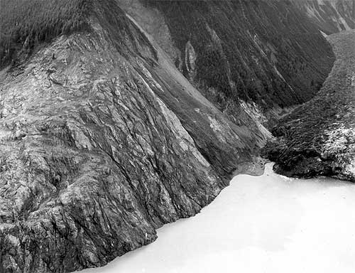
<span class=jpg Trees washed out and turned upslope by water at altitude of 1,720 feet." align="bottom" border="0" height="384" width="500">
Trees washed out and turned upslope by water at altitude of 1,720 feet. Small slides occurred on steep slope at right during the 1958 earthquake, but destruction of forest in middle and lower left part of view is due mainly to water. Lituya district, Alaska Gulf region, Alaska. Glacier Bay National Park and Preserve. Plate 7-A in U.S. Geological Survey.
Photograph courtesy U.S. Geological Survey


The weather also plays a role in the bay as it gets a large amount of precipitation - mostly rainfall. Some of the inland areas along the coast between Lituya Bay and Yakutat have had more than 300 inches of rain according to the National Weather Service and the winter and spring of 1958 was a wet one throughout Southeast Alaska. The ground in Lituya Bay - which frequently gets up to 150 inches of rain a year - was oversaturated even though it was sunny that July.

The third factor was the massive earthquakes that frequently topped 6 and 7 on Richter Scale in the area.

A final factor was the deep water - up to 800 feet - near the head of the bay. When earthquakes or other events caused landslides, they would displace large amounts of water sending it rushing toward the narrow mouth of the bay and the open ocean.

Federal geologist Don Miller was the foremost expert on Lituya Bay in the 1950s and the early 1960s. In his 1960 report, "Giant Waves in Lituya Bay Alaska." he pointed out evidence of five "giant" waves created primarily by land or glacier slides between 1853 and 1958.


<span class=jpg Lituya Bay, 1954, trimlines of the 1936 giant waves and the 1853-54 giant wave" align="bottom" border="0" height="397" width="500">
Aerial view of Lituya Bay, 1954, trimlines of the 1936 giant waves and the 1853-54 giant wave. Lateral moraines and the end moraine in the right and left foreground record a recent advance of ice to the mouth of the bay. Mount Crillon altitude 12,726 feet is the highest peak on the skyline. Lituya district, Alaska Gulf region, Alaska. September 16, 1954. Plate 3-A in U.S. Geological Survey.
Photograph courtesy U.S. Geological Survey


The 1853-54 wave was estimated at 395 feet, the 1874 wave at 80 feet, the 1899 wave at 200 feet, the 1936 wave at 490 feet and the 1958 behemoth swept trees off a hillside at more than 1,720 feet.

In addition to those giant waves, the waters of Lituya Bay had also been the site of several other disasters involving both the native Tlingit tribes and groups of American, British and French explorers and adventurers from the 1780s into the Twentieth Century, according to Philip Fradkin in his 2001 book "Wildest Alaska: Journeys of Great Peril in Lituya Bay."

Most of these involved the deadly, narrow entrance that featured tide rips and waters running up to 13 knots in either direction. Most notable was a disaster that cost French explorer Jean-Francois La Perouse more than 20 of his sailors. Fradkin also noted that Tlingit oral tradition featured several stories of "giant" waves and mass drownings in the bay.

Three Boats In the Bay

There were two commonly used anchorages near the mouth of Lituya Bay on that July night in 1958. Ulrich and his eight-year-old son "Sonny" chose to anchor about half a mile in from the mouth on the south side of the bay in place called, appropriately enough "Anchorage Cove."

Two other trolling boats, the Sunmore (with Orville and Mickey Wagner on board) and the Badger (operated by Bill and Vivian Swanson) anchored up on the opposite side of the bay, just behind the nearly mile long spit that extended most of the way across the mouth of the bay. The opening itself was less than 300 yards across and most of that water was too shallow for boats to cross. Some fishermen estimate there may less than 50 feet of open water at times.

The Ulrichs had anchored up just after 8 pm, while the other two boats - running partners who both lived in Juneau - anchored up around 9 pm.

Around 8 pm, a plane took off from near Cenotaph Island (so named after the drowning of the 20 French sailors in 1786). On board were 10 Canadians who had just returned from the first Canadian ascent of Mount Fairweather.


<span class=jpg Stump of living spruce tree broken off by the giant wave at Harbor Point, mouth of Lituya Bay" align="bottom" border="0" height="426" width="500">
Stump of living spruce tree broken off by the giant wave at Harbor Point, mouth of Lituya Bay. Brim of hat is 12 inches in diameter. Lituya district, Alaska Gulf region, Alaska. Plate 5-B in U.S. Geological Survey.
Photograph courtesy U.S. Geological Survey

"The expedition was scheduled to leave the following day, but the pilot of their Royal Canadian Air Force amphibian arrived at 6 pm that night and told them to pack immediately," Fradkin wrote in "Wildest Alaska." "He was worried about the possibility of fog and wanted to get the climbers back to Juneau that night. The climbers cursed the pilot's nervousness. They missed dinner in a hurry to pack and departed at 9 pm. Another party of climbers was due that day by boat but they had been delayedHad the two groups proceeded as planned, there would have been a total of 20 climbers camped on the shoreline that night."

Fradkin noted that the Canadian climbers weren't the only living things making a fortuitous getaway from the bay.

"As the Canadian climbers flew away, so did the nervous kittiwakes (that nested on the cliffs of Cenotaph Island)," Fradkin wrote. "The gulls ascended like so much confetti blown upward. The high intensity alarm call of thousands of birds echoed through the still bay. They passed over the Badger and splattered the boat with droppings. Some crashed into the vessel's rigging and plummeted to the deck. The Swansons were frightened."

Up and down the coast as far as Yakutat and Hoonah observers would report similar odd behavior by shore birds and other animals. Then, at approximately 10:16 pm, it happened.

"Cursing Myself For Not Moving Sooner"

The quake was later determined to be 8.3 on the earthquake scale and was centered 45 miles south of Lituya in Cross Sound. It was felt strongly as far south as Seattle and as far north as Anchorage. At Yakutat, 80 miles to the north of Lituya, three people out berry picking died instantly when a small island they were on immediately dropped more than two dozen feet under the water. Later measurements determined that a nearby mountain had risen more than 50 feet at the same time.

Overall, the earth had moved some 21 feet horizontally and 3.5 feet vertically along most of the fault line. While most earthquakes last only a few seconds, the initial length of the quake was later estimated at more than two minutes by Don Miller.

Then Lituya Bay got hit with the other shoe.

Miller - who was in Glacier Bay at the time of quake and flew to Lituya the next day - determined that less than two minutes after the initial tremor, the side of an unnamed 5,616 foot peak on the east side of Gilbert Inlet (at the head of the bay) plunged into the bay. At least 2,000 feet of rock fell.

"The noise was deafening," Fradkin wrote. "The violent impact of forty million cubic yards of rock, ice and coarse soil weighing ninety million tonswas heard 50 miles to the north. Ulrich said it sounded like an explosion."

With the first jolt, Bill Swanson tumbled out of his bunk on the Badger. He later told the Alaska Sportsman that the he could see even the highest mountains shaking. Then he saw the Lituya Glacier appear to literally rise up into the air.

"I know you can't ordinarily see that glacier from where I was anchored," he was quoted in the October, 1958 issue. "People shake their head when I tell them I saw it that night. I can't help it if they don't believe mebut I know what I saw that night."

From his vantage point, he could also see the mountainside slide away and crash towards the water. From his viewpoint on the other side of the bay, Ulrich could see the wave rise up and devastate the forested hillside.

All three boat crews had been woken up by the earthquake. But while the captains of the Badger and Edrie were transfixed by the spectacle at the head of the bay, the Wagners on the Sunmore jumped to immediate action and got their boat headed out of the bay.

It proved to be a fatal decision. Swanson reported seeing the Sunmore just about to turn out into the entrance when it was caught by the wave and flung over Harbor Point across the opening from the end of the spit. All that was found later was an oil slick marking the spot where the boat went down in deep water.

Ulrich told Alaska Sportsman that he was "petrified" by the landslide and the wave and didn't begin to act until he saw the wave, then still some 300 feet high engulf Cenotaph Island some two miles away from his boat.

"I began to move then," he said. "And I moved fast, cursing myself for not moving sooner."

" I Think We've Had It. Goodbye"

He got a life jacket on his son and started the engine. He started to pull the anchor and found it unmovable.

"The wave (then estimated at more than 75 feet high) was almost upon us and we were fastened to the bottom with a heavy chain," Ulrich said. He surmised that the quake had caused the anchor to get tangled on the bottom. He let out all his extra chain, in hopes that it would be enough to allow the boat to ride up and over the wave. Then he turned the boat into the wave and held on.


Southeast Alaska Earthquake, July 10, 1958. Wave damage on the south shore of Lituya Bay, from Harbor Point to the spur southwest of Crillon Inlet. August 9, 1958. Photos mdj01247 through mdj01261 form a sequence of fifteen photographs.
Photograph courtesy U.S. Geological Survey


"As the Edrie began her almost perpendicular ascent to the crest of the wave, the chain snapped," Ulrich said, adding that he wanted to get a message out so his wife in Pelican would eventually find out her husband and son had died. "There seemed to be no hope for survivalI grabbed the handset of my radiophone and yelled into it: 'Mayday! Mayday! This is the Edrie in in Lituya Bay. All hell has broken loose in hereI think we've had it. Goodbye.' "

But the luck that had abandoned the Wagners was still on Ulrich's side. At the top of wave, he regained enough control of his boat to hold on and steer around the debris being carried by the wave. A few seconds later, the worst had passed.

He sent out another message saying he thought they'd made it through. Immediately, other boats outside Lituya began radioing back. But, Ulrich noted, the silence from the Badger and the Sunmore was ominous.

Just about the time that Bill Swanson saw the wave engulf the Sunmore as it tried to escape, the wave - estimated to be approximately 80 feet high - hit his boat and carried it over the La Chaussee Spit and dumped it stern first into the open ocean.

"We went way over the trees and I looked down on rocks as big as an ordinary house as we crossed the spit," Swanson told the Alaska Sportsman. "We were way up above them. It felt like we were in a tin can and somebody was shaking it."

After the crash landing, the boat immediately began to sink. They were surrounded by acres of wood debris - including a large tree that smashed through the pilot house and broke several of Swanson's ribs - but managed to get into eight foot skiff with only their underclothes on, according to Fradkin's book. At nearly midnight, they were found by the crew of the vessel Lumen which was picking its way through the miles of debris looking for signs of survivors in the pitch dark.

After surviving the giant Lituya wave, Ulrich continued to fish but then quit the business a year later. As recently as 2004, he was still reliving the events of July 9, 1958. He wrote a brief story that appeared in Esquire magazine about that night under the title "What it Feels Like to Survive a Tsunami."

The Swansons eventually got a replacement boat, but Vivian - whose hair reportedly turned gray overnight after the Lituya incident - refused to go fishing with Bill again, according to Fradkin.

On the night of May 26, 1962. Bill Swanson returned to Lituya Bay for the first time since the wave in 1958. Shortly after passing through the narrow entrance to the bay, he suffered a massive heart attack and died.


WEATHER NOTE

LATEST ON FAY

Tropical Storm FAY Public Advisory Number 19A

3 Day Forecast Track
3 Day Forecast Track - Click to enlarge


Web makes it easy for stormchasers to track weather
ROBERT NOLIN

In ancient times, before the Internet ruled the world, folks needed pencil, straightedge and a rudimentary knowledge of latitude and longitude to track a storm like the wannabe tropical depression now knocking at the Caribbean's door.

No longer.

Now all an amateur storm chaser needs is a keyboard and mouse. In recent years, meteorological-based Web sites, including that of the U.S. government's own National Hurricane Center, have become sophisticated enough to drench even the most demanding weather buff with information.

"They've improved, they're faster, they have more information," said Scott Weiner, 41, who flicks on the computer when he hankers to follow a storm's progress. "The first place I go is the (South Florida) Sun Sentinel."

This newspaper's hurricane-related Web fixture, sunsentinel.com/hurricane, offers real-time storm tracking, a weather blog, satellite maps, storm histories and other features.

With an average of 38 million page views a month, the Weather Channel's Web site, weather.com, leads the pack in terms of popularity, according to Nielsen/NetRating. Users charting a storm don't want to wait for broadcast reports, site spokeswoman Melissa Medori said.

"I guess it's the usage pattern of 'I want it now. I don't want to have to wait for the next update,'" she said.

Rapid, frequent updates are indeed the draw for Weiner, as are fancy graphics and blogs. "I want to look at the maps, the projections," he said. "TV weather is useless."

If a storm is thrashing around the neighborhood, visits to weather Web sites spike.

"When there's any tropical storm or hurricane threatening land, especially U.S. soil, our traffic goes up approximately 50 percent," said Toby Skinner of The Weather Underground, the second-most popular site. "We talking such huge numbers we have to make plans to make sure our whole system doesn't break down."

Last month, when Hurricane Dolly barreled toward Texas, about 22 million visited wunderground.com in one day, Skinner said. "It's even more than we had with Katrina," he added, referring to the 2005 hurricane that wrecked New Orleans. "We're showing gradual increases year upon year."

Weather Web sites all use the same material from the National Hurricane Center in Miami-Dade County, but they customize maps, computer model tracks and snazzy graphics to enthrall viewers. Weather.com tosses in raw storm videos, photos and pet pictures. Another site, skeetobiteweather.com, prides itself on a more businesslike presentation.

The hurricane center has jazzed up its own site Web site to make it more layperson-friendly, said spokesman Dennis Feltgen. "We're in the 21st Century, we've got high-resolution graphics, we've taken the text piece and basically made it graphical."

The result, he said, has drawn 4 million page clicks to the site so far this year - not bad for a government venue. "They're clearly seeking the information out and they're quite savvy," Feltgen said of the mouse-wielding public.

But he cautioned that big decisions, such as when to shutter up or evacuate, should be left to professionals, and not armchair prognosticators.

"We certainly would not encourage them to make their own interpretation of track forecasts and intensity forecasts," he said. "We've got a number of scientists here at the center and that's what they're trained to do."

Hurricanes and climate change: A sharper view

August 13, 2008

In a study published in the July 2008 issue of Geophysical Research Letters, Drs. David S. Nolan and Eric D. Rappin from the University of Miami's Rosenstiel School of Marine and Atmospheric Science describe a new method for evaluating the frequency of hurricane formation in present and future tropical climates. While current thinking about changes in hurricane frequency comes mostly from computer simulations of global climate, the computer models used for these studies can only represent the coarsest features of hurricanes, thus casting doubt in their predictions of hurricane activity.

The new approach by Nolan and Rappin, developed in collaboration with Dr. Kerry Emanuel of the Massachusetts Institute of Technology, uses computer models with much more accurate representation of the processes that lead to hurricane formation, much the same way a digital image with more pixels allows for a more detailed photographic image. The models are used to simulate the rate of hurricane development in tropical atmospheres with varying values of sea surface temperature and vertical wind shear (which is the extent to which wind speed and direction changes with height in the atmosphere). These two variables - ocean temperature and wind shear -- are considered to be the two most important factors in predicting hurricane activity, both in operational forecasting and in consideration of climate change.

MARITIME NOTE

Riverdance ferry - a sorry sight


These pictures by Gazette photographer Bill Johnson show the pitiful remains of the wrecked Riverdance ferry – seven months after it ran aground off the Cleveleys coast.

What began as a huge tourist attraction – the sight of the beached vessel has brought thousands of trippers to the seafront – now looks more like a rusted shed as demolition teams have reduced it to a sorry sight.

Both engines have been removed from the 6,000 tonne ship and carted off to a spares company in the North East of England.

More than 34,000 litres of oil had to be taken off the stricken cargo ferry and other potential marine pollutants have also been removed. It will not be long before the wreck – which has been photographed by visitors from across the world since it became beached in heavy seas on January 31 – is completely removed.

Demolition experts from Hancock's Contractors Ltd and PGC Demolition Ltd have been working over the last two months to dismantle the ship piece by piece.

But it is painstaking and difficult work – depending on the weather and tidal patterns.

Fred Caygill, from the Maritime and Coastguard Agency, said: "The vessel has been stripped down internally, it's only the shell that remains.

"Sections are being cut off and the pieces being transported for recycling.

"The teams are making good progress and have done meticulous work.

"There is not a lot left of the ship now. All the work has been done without any loss or damage to the local environment.

"The work still remains on schedule, but we cannot give an exact completion date because it depends on the tides and the weather.

"But we are expecting the work to be completed around the end of September to early October."


RS
Posted by Robin Storm - In Search of Severe Weather. at 00:01 No comments:

Labels: Freak Wave, hurricanes, large waves, m/f riverdance, severe weather, storm chasers
Older Posts Home
Subscribe to: Posts (Atom)

NEW - The Ship Watcher

watcher

EXPERIMENTAL - KLOT Snowfall Map

snowfall

WRN Ambassador

2009 National Severe Weather Workshop

Workshop
BunnyERabbit `
NOAA
Remote
NCDDC
NCDDC
National Weather Service
NWS Skywarn
VOS Reportst
GLERL
storm pulse

Dundee Tracking Station

Dundee
NODC
Geology Times `
NASCAS
Robin Storm
Big Med
Mesoanalysis
NIU Weather
National Lighting Safety
Hurricane Watch.Net
Stormtrax
Storm Report
Tropical Meteorology
Valparaiso University Storm Intercept Team
College of DuPage
Severe Studios

The Cargo Letter

Cargo Law

Maritime Transportation And Shipping Talk

shiptalk
COSPAS SARSAT
Messing About In Ships Podcast
Sea-Fever.Org
Nautical Anchor
Art Of Dredging
Life At Sea
VesselTrax
Mariitime Accident Casebook
MarEx
Marine Firefighting Institute
Embassy Suites Chicago

About Me

My photo
Robin Storm - In Search of Severe Weather.

My name is Jay Cafasso and I am a retired hazardous mateials specialist and corporate executive. I am also a NWS advanced storm spotter. Robin Storm seeks to educate the public regarding severe weather as well as scientifically intercept and observe severe storm. We chase safely to intercept and observe storms and report our observation to the local NWS/WFO so they can keep you better informed. Remember, safety first always!
View my complete profile

Site Purpose and Fair Use

The purpose of this site is to educate the public on the topics of 'severe weather" and its effects on the "maritime service". Articles are drawn from a variety of sources both government and private and re posted in partial or full text. Article credit is linked or posted.

The information contained on this site is for educational purposes only and is not intended for any particular person and or circumstance nor for profit.

The author of this site makes no express warranties or guarantees.

OSEI Pix Of The Day!

OSEI Pix Of The Day!

Photo of the Day

Photo of the Day
Landspout Lowell, Indiana

Indiana Dunes Nowcast

Indiana Dunes Nowcast

GL Vessel Passage

Vessel Locations

Seaway Vessel Passage

Seaway Vessel Locations

Worldwide Ship Locator

Worldwide Ship Locator

Latest Vessel Casualties

Latest Vessel Casualties

Marine Forecast

mforecast

Southeastern U.S. Marine Weather

Marine Portal

Worldwide Cloud Cover

cloud

OPC Atlantic Alalysis

OPC

OPC Atlantic Analysis

OPC Atlantic Analysis
Wind and Wave

OPC Pacific Analysis

OPCP

OPC Pacific Analysis

OPC Pacific Analysis
Wind and Wave

Offshore NHC Enhancement

Offshore NHC Enhancement

CONUS Lightning Strikes

Lightening Strikes

SPC Activity Chart

SPC Activity Chart

SPC Mesoanalysis Sectors

SPC Mesoanalysis Sectors

WX Warnings

Storm Track - Carib

Storm Track - Carib

Morphed Composite

Morphed Composite
Atlantic

Hurricane Tracking IR

Hurricane Tracking IR
Updates every 30 minutes

National Hurricane Center

National Hurricane Center

Western/South Pacific

Western/South Pacific

South Pacific

South Pacific

Illinois WX

Illinois WX
Base Reflectivity - NEXLAB

Latest Illinois Region

Latest Illinois Region
NEXLAB

Weather Story - LOT

Weather Story - LOT

South Central CONUS

South Central CONUS
NexLab

GOES - CONUS

GOES - CONUS

GOES IR CONUS

GOES IR CONUS

The "Cape Of Needles"

The "Cape Of Needles"
Just for Lighthouse

Middle East

Middle East

METEOSAT IR Africa

METEOSAT IR Africa
Updated Every 6 Hours

GOES (vis) Pacific

GOES (vis) Pacific

MTSAT - Japan

MTSAT - Japan

Keeping an eye on Wilkins Ice Shelf

Keeping an eye on Wilkins Ice Shelf

Buoy CHII2 Webcam

Buoy CHII2 Webcam
Three Miles Offshore

Chicago Water Tower

Chicago Water Tower

Chicago - Looking South

Chicago - Looking South

MIlwaukee, Wisconsin

MIlwaukee, Wisconsin

Toledo Light #2

Toledo Light #2

Dundee, Scottland

Dundee, Scottland
Satellite Receiving Station Webcam

Wellington, Harbor, NZ

Wellington, Harbor,  NZ
Harbor Cam

Port De Brest - France

Port De Brest - France
Harbor Cam

North Pole Webcam

North Pole Webcam
Updated every 14 days

ShipCam

ShipCam
Green Peace Esperanza

ShipCam

ShipCam
Caribbean Princess

ShipCam

ShipCam
P&O Arcadia

A Bad Sign or SLC?

A Bad Sign or SLC?

A Real Bad Sign!

A Real Bad Sign!

Surfs Up!

Surfs Up!

What Rock?

What Rock?

Oh My Aching Bow!

Oh My Aching Bow!

Hot Night In Bay City!

Hot Night In Bay City!

It Just Popped UP!

It Just Popped UP!

What A Sunset!

What A Sunset!

Blog Archive

  • ▼  2014 (18)
    • ▼  March (3)
      • ▼  Mar 22 (1)
        • Visit us at Twitter! @teamrobinstorm
      • ►  Mar 20 (1)
      • ►  Mar 01 (1)
    • ►  February (15)
      • ►  Feb 26 (1)
      • ►  Feb 14 (1)
      • ►  Feb 11 (1)
      • ►  Feb 10 (1)
      • ►  Feb 08 (1)
      • ►  Feb 07 (1)
      • ►  Feb 06 (2)
      • ►  Feb 05 (1)
      • ►  Feb 04 (2)
      • ►  Feb 03 (1)
      • ►  Feb 02 (1)
      • ►  Feb 01 (2)
  • ►  2009 (24)
    • ►  February (1)
      • ►  Feb 02 (1)
    • ►  January (23)
      • ►  Jan 30 (1)
      • ►  Jan 29 (1)
      • ►  Jan 28 (1)
      • ►  Jan 27 (1)
      • ►  Jan 26 (1)
      • ►  Jan 23 (1)
      • ►  Jan 22 (1)
      • ►  Jan 21 (1)
      • ►  Jan 20 (1)
      • ►  Jan 19 (1)
      • ►  Jan 17 (1)
      • ►  Jan 16 (2)
      • ►  Jan 15 (2)
      • ►  Jan 14 (1)
      • ►  Jan 13 (1)
      • ►  Jan 12 (1)
      • ►  Jan 09 (1)
      • ►  Jan 08 (1)
      • ►  Jan 07 (1)
      • ►  Jan 06 (1)
      • ►  Jan 05 (1)
  • ►  2008 (270)
    • ►  December (22)
      • ►  Dec 31 (1)
      • ►  Dec 30 (1)
      • ►  Dec 29 (1)
      • ►  Dec 24 (1)
      • ►  Dec 23 (1)
      • ►  Dec 22 (1)
      • ►  Dec 19 (1)
      • ►  Dec 18 (1)
      • ►  Dec 17 (1)
      • ►  Dec 16 (1)
      • ►  Dec 15 (1)
      • ►  Dec 12 (1)
      • ►  Dec 11 (1)
      • ►  Dec 10 (1)
      • ►  Dec 09 (1)
      • ►  Dec 08 (1)
      • ►  Dec 06 (1)
      • ►  Dec 05 (1)
      • ►  Dec 04 (1)
      • ►  Dec 03 (1)
      • ►  Dec 02 (1)
      • ►  Dec 01 (1)
    • ►  November (20)
      • ►  Nov 28 (1)
      • ►  Nov 27 (1)
      • ►  Nov 26 (1)
      • ►  Nov 25 (1)
      • ►  Nov 24 (1)
      • ►  Nov 21 (1)
      • ►  Nov 20 (1)
      • ►  Nov 19 (1)
      • ►  Nov 18 (1)
      • ►  Nov 17 (1)
      • ►  Nov 14 (1)
      • ►  Nov 13 (1)
      • ►  Nov 12 (1)
      • ►  Nov 11 (1)
      • ►  Nov 10 (1)
      • ►  Nov 07 (1)
      • ►  Nov 06 (1)
      • ►  Nov 05 (1)
      • ►  Nov 04 (1)
      • ►  Nov 03 (1)
    • ►  October (22)
      • ►  Oct 31 (1)
      • ►  Oct 30 (1)
      • ►  Oct 29 (1)
      • ►  Oct 28 (1)
      • ►  Oct 27 (1)
      • ►  Oct 24 (1)
      • ►  Oct 23 (1)
      • ►  Oct 22 (1)
      • ►  Oct 21 (1)
      • ►  Oct 20 (1)
      • ►  Oct 17 (1)
      • ►  Oct 16 (1)
      • ►  Oct 15 (1)
      • ►  Oct 13 (1)
      • ►  Oct 10 (1)
      • ►  Oct 09 (1)
      • ►  Oct 08 (1)
      • ►  Oct 07 (1)
      • ►  Oct 06 (1)
      • ►  Oct 03 (1)
      • ►  Oct 02 (1)
      • ►  Oct 01 (1)
    • ►  September (28)
      • ►  Sep 30 (1)
      • ►  Sep 29 (1)
      • ►  Sep 27 (1)
      • ►  Sep 26 (1)
      • ►  Sep 25 (1)
      • ►  Sep 24 (1)
      • ►  Sep 23 (1)
      • ►  Sep 22 (1)
      • ►  Sep 21 (1)
      • ►  Sep 20 (1)
      • ►  Sep 19 (1)
      • ►  Sep 18 (1)
      • ►  Sep 17 (1)
      • ►  Sep 16 (1)
      • ►  Sep 15 (1)
      • ►  Sep 13 (1)
      • ►  Sep 12 (1)
      • ►  Sep 11 (1)
      • ►  Sep 10 (1)
      • ►  Sep 09 (1)
      • ►  Sep 08 (2)
      • ►  Sep 06 (1)
      • ►  Sep 05 (1)
      • ►  Sep 04 (1)
      • ►  Sep 03 (1)
      • ►  Sep 02 (1)
      • ►  Sep 01 (1)
    • ►  August (23)
      • ►  Aug 29 (1)
      • ►  Aug 28 (1)
      • ►  Aug 27 (1)
      • ►  Aug 26 (1)
      • ►  Aug 25 (1)
      • ►  Aug 22 (1)
      • ►  Aug 21 (1)
      • ►  Aug 20 (1)
      • ►  Aug 19 (1)
      • ►  Aug 18 (1)
      • ►  Aug 15 (1)
      • ►  Aug 14 (1)
      • ►  Aug 13 (1)
      • ►  Aug 12 (1)
      • ►  Aug 11 (1)
      • ►  Aug 08 (1)
      • ►  Aug 07 (1)
      • ►  Aug 06 (1)
      • ►  Aug 05 (1)
      • ►  Aug 04 (1)
      • ►  Aug 03 (1)
      • ►  Aug 02 (1)
      • ►  Aug 01 (1)
    • ►  July (23)
      • ►  Jul 31 (1)
      • ►  Jul 30 (1)
      • ►  Jul 29 (1)
      • ►  Jul 28 (1)
      • ►  Jul 25 (1)
      • ►  Jul 24 (1)
      • ►  Jul 23 (1)
      • ►  Jul 22 (1)
      • ►  Jul 21 (1)
      • ►  Jul 18 (1)
      • ►  Jul 17 (1)
      • ►  Jul 16 (1)
      • ►  Jul 15 (1)
      • ►  Jul 14 (1)
      • ►  Jul 11 (1)
      • ►  Jul 10 (1)
      • ►  Jul 09 (1)
      • ►  Jul 08 (1)
      • ►  Jul 07 (1)
      • ►  Jul 04 (1)
      • ►  Jul 03 (1)
      • ►  Jul 02 (1)
      • ►  Jul 01 (1)
    • ►  June (21)
      • ►  Jun 30 (1)
      • ►  Jun 27 (1)
      • ►  Jun 26 (1)
      • ►  Jun 25 (1)
      • ►  Jun 24 (1)
      • ►  Jun 23 (1)
      • ►  Jun 20 (1)
      • ►  Jun 19 (1)
      • ►  Jun 18 (1)
      • ►  Jun 17 (1)
      • ►  Jun 16 (1)
      • ►  Jun 13 (1)
      • ►  Jun 12 (1)
      • ►  Jun 11 (1)
      • ►  Jun 10 (1)
      • ►  Jun 09 (1)
      • ►  Jun 06 (1)
      • ►  Jun 05 (1)
      • ►  Jun 04 (1)
      • ►  Jun 03 (1)
      • ►  Jun 02 (1)
    • ►  May (24)
      • ►  May 30 (1)
      • ►  May 29 (1)
      • ►  May 28 (1)
      • ►  May 27 (2)
      • ►  May 26 (1)
      • ►  May 23 (1)
      • ►  May 22 (1)
      • ►  May 21 (1)
      • ►  May 20 (1)
      • ►  May 19 (1)
      • ►  May 16 (1)
      • ►  May 15 (1)
      • ►  May 14 (1)
      • ►  May 13 (1)
      • ►  May 12 (1)
      • ►  May 09 (1)
      • ►  May 08 (1)
      • ►  May 07 (1)
      • ►  May 06 (1)
      • ►  May 05 (1)
      • ►  May 04 (1)
      • ►  May 02 (1)
      • ►  May 01 (1)
    • ►  April (22)
      • ►  Apr 30 (1)
      • ►  Apr 29 (1)
      • ►  Apr 28 (1)
      • ►  Apr 25 (1)
      • ►  Apr 24 (1)
      • ►  Apr 23 (1)
      • ►  Apr 22 (1)
      • ►  Apr 21 (1)
      • ►  Apr 18 (1)
      • ►  Apr 17 (1)
      • ►  Apr 16 (1)
      • ►  Apr 15 (1)
      • ►  Apr 14 (1)
      • ►  Apr 11 (1)
      • ►  Apr 10 (1)
      • ►  Apr 09 (1)
      • ►  Apr 08 (1)
      • ►  Apr 07 (1)
      • ►  Apr 04 (1)
      • ►  Apr 03 (1)
      • ►  Apr 02 (1)
      • ►  Apr 01 (1)
    • ►  March (22)
      • ►  Mar 31 (1)
      • ►  Mar 28 (1)
      • ►  Mar 27 (1)
      • ►  Mar 26 (1)
      • ►  Mar 25 (1)
      • ►  Mar 24 (1)
      • ►  Mar 21 (1)
      • ►  Mar 20 (1)
      • ►  Mar 19 (1)
      • ►  Mar 18 (1)
      • ►  Mar 17 (1)
      • ►  Mar 15 (1)
      • ►  Mar 14 (1)
      • ►  Mar 13 (1)
      • ►  Mar 12 (1)
      • ►  Mar 11 (1)
      • ►  Mar 10 (1)
      • ►  Mar 07 (1)
      • ►  Mar 06 (1)
      • ►  Mar 05 (1)
      • ►  Mar 04 (1)
      • ►  Mar 03 (1)
    • ►  February (21)
      • ►  Feb 29 (1)
      • ►  Feb 28 (1)
      • ►  Feb 27 (1)
      • ►  Feb 26 (1)
      • ►  Feb 25 (1)
      • ►  Feb 22 (1)
      • ►  Feb 21 (1)
      • ►  Feb 20 (1)
      • ►  Feb 19 (1)
      • ►  Feb 18 (1)
      • ►  Feb 15 (1)
      • ►  Feb 14 (1)
      • ►  Feb 13 (1)
      • ►  Feb 12 (1)
      • ►  Feb 08 (1)
      • ►  Feb 07 (1)
      • ►  Feb 06 (1)
      • ►  Feb 05 (1)
      • ►  Feb 04 (1)
      • ►  Feb 02 (1)
      • ►  Feb 01 (1)
    • ►  January (22)
      • ►  Jan 31 (1)
      • ►  Jan 30 (1)
      • ►  Jan 28 (1)
      • ►  Jan 25 (1)
      • ►  Jan 24 (1)
      • ►  Jan 23 (1)
      • ►  Jan 22 (1)
      • ►  Jan 18 (1)
      • ►  Jan 17 (1)
      • ►  Jan 16 (1)
      • ►  Jan 15 (1)
      • ►  Jan 14 (1)
      • ►  Jan 11 (1)
      • ►  Jan 10 (1)
      • ►  Jan 09 (1)
      • ►  Jan 08 (1)
      • ►  Jan 07 (1)
      • ►  Jan 05 (1)
      • ►  Jan 04 (1)
      • ►  Jan 03 (1)
      • ►  Jan 02 (1)
      • ►  Jan 01 (1)
  • ►  2007 (168)
    • ►  December (13)
      • ►  Dec 28 (1)
      • ►  Dec 27 (1)
      • ►  Dec 26 (1)
      • ►  Dec 24 (1)
      • ►  Dec 21 (1)
      • ►  Dec 18 (1)
      • ►  Dec 17 (1)
      • ►  Dec 16 (2)
      • ►  Dec 15 (2)
      • ►  Dec 04 (1)
      • ►  Dec 01 (1)
    • ►  November (20)
      • ►  Nov 29 (1)
      • ►  Nov 27 (1)
      • ►  Nov 26 (1)
      • ►  Nov 23 (1)
      • ►  Nov 21 (2)
      • ►  Nov 20 (1)
      • ►  Nov 19 (1)
      • ►  Nov 16 (1)
      • ►  Nov 15 (1)
      • ►  Nov 14 (1)
      • ►  Nov 13 (1)
      • ►  Nov 12 (1)
      • ►  Nov 09 (1)
      • ►  Nov 08 (1)
      • ►  Nov 07 (1)
      • ►  Nov 06 (1)
      • ►  Nov 05 (1)
      • ►  Nov 02 (1)
      • ►  Nov 01 (1)
    • ►  October (24)
      • ►  Oct 31 (1)
      • ►  Oct 30 (1)
      • ►  Oct 29 (1)
      • ►  Oct 26 (1)
      • ►  Oct 25 (1)
      • ►  Oct 24 (1)
      • ►  Oct 23 (1)
      • ►  Oct 22 (1)
      • ►  Oct 19 (1)
      • ►  Oct 18 (1)
      • ►  Oct 17 (2)
      • ►  Oct 16 (1)
      • ►  Oct 15 (1)
      • ►  Oct 12 (1)
      • ►  Oct 11 (1)
      • ►  Oct 10 (1)
      • ►  Oct 09 (1)
      • ►  Oct 08 (1)
      • ►  Oct 05 (1)
      • ►  Oct 03 (2)
      • ►  Oct 02 (1)
      • ►  Oct 01 (1)
    • ►  September (22)
      • ►  Sep 28 (1)
      • ►  Sep 27 (1)
      • ►  Sep 26 (1)
      • ►  Sep 25 (1)
      • ►  Sep 24 (1)
      • ►  Sep 21 (2)
      • ►  Sep 20 (1)
      • ►  Sep 18 (1)
      • ►  Sep 17 (1)
      • ►  Sep 14 (1)
      • ►  Sep 13 (1)
      • ►  Sep 12 (1)
      • ►  Sep 10 (1)
      • ►  Sep 07 (1)
      • ►  Sep 06 (1)
      • ►  Sep 04 (2)
      • ►  Sep 03 (2)
      • ►  Sep 02 (2)
    • ►  August (31)
      • ►  Aug 31 (1)
      • ►  Aug 30 (1)
      • ►  Aug 29 (1)
      • ►  Aug 28 (1)
      • ►  Aug 27 (1)
      • ►  Aug 25 (1)
      • ►  Aug 24 (2)
      • ►  Aug 23 (1)
      • ►  Aug 22 (1)
      • ►  Aug 21 (1)
      • ►  Aug 20 (1)
      • ►  Aug 19 (2)
      • ►  Aug 18 (1)
      • ►  Aug 17 (1)
      • ►  Aug 16 (2)
      • ►  Aug 15 (2)
      • ►  Aug 14 (1)
      • ►  Aug 13 (1)
      • ►  Aug 11 (1)
      • ►  Aug 10 (1)
      • ►  Aug 09 (1)
      • ►  Aug 08 (1)
      • ►  Aug 07 (1)
      • ►  Aug 06 (1)
      • ►  Aug 03 (1)
      • ►  Aug 02 (1)
      • ►  Aug 01 (1)
    • ►  July (23)
      • ►  Jul 30 (1)
      • ►  Jul 29 (1)
      • ►  Jul 27 (1)
      • ►  Jul 26 (1)
      • ►  Jul 25 (1)
      • ►  Jul 24 (1)
      • ►  Jul 23 (1)
      • ►  Jul 20 (1)
      • ►  Jul 19 (1)
      • ►  Jul 18 (1)
      • ►  Jul 17 (1)
      • ►  Jul 16 (1)
      • ►  Jul 13 (1)
      • ►  Jul 12 (2)
      • ►  Jul 11 (1)
      • ►  Jul 09 (2)
      • ►  Jul 06 (1)
      • ►  Jul 05 (1)
      • ►  Jul 04 (1)
      • ►  Jul 03 (1)
      • ►  Jul 02 (1)
    • ►  June (24)
      • ►  Jun 29 (1)
      • ►  Jun 28 (1)
      • ►  Jun 27 (1)
      • ►  Jun 26 (1)
      • ►  Jun 25 (1)
      • ►  Jun 22 (1)
      • ►  Jun 21 (1)
      • ►  Jun 20 (1)
      • ►  Jun 19 (1)
      • ►  Jun 18 (1)
      • ►  Jun 15 (1)
      • ►  Jun 14 (2)
      • ►  Jun 13 (1)
      • ►  Jun 11 (1)
      • ►  Jun 09 (1)
      • ►  Jun 08 (1)
      • ►  Jun 07 (3)
      • ►  Jun 05 (1)
      • ►  Jun 04 (2)
      • ►  Jun 01 (1)
    • ►  May (11)
      • ►  May 31 (1)
      • ►  May 30 (1)
      • ►  May 21 (1)
      • ►  May 17 (1)
      • ►  May 16 (1)
      • ►  May 15 (3)
      • ►  May 14 (1)
      • ►  May 12 (1)
      • ►  May 11 (1)

My Personal Favorites

  • Arms Control Wonk
  • Fred Fry International
  • gCaptain
  • Maritime Accident Casebook
  • No Quarter
  • Sic Semper Tyrannis

Marine Links & Blogs

  • Bitter End
  • Boat Watch
  • Cargolaw.com
  • Cruiser Log
  • Cruising Connections
  • Fred Fry International
  • gCaptain.com
  • IMO
  • John's Nautical Links List
  • John's Nautical Links List
  • Kiwi At Sea
  • Life Of A Sea Wife
  • Lloyd's List News
  • MarineBuzz.com
  • Maritime Accident Case Book
  • Maritime Links
  • Maritime Reporter
  • MaritimeTerrorism.com
  • ONI Threat To Shipping
  • Professional Mariner.Com
  • Sea Fever
  • Shipinfo Link
  • Steve's Maritime Page
  • The Monitor
  • The Pilot Boat
  • United States Coast Guard
  • Unofficial Coast Guard Blog
  • Unofficial Coast Guard Blog
  • USCG Marine Safety Office
  • VesselTrax
  • World Cargo News
  • Yankee Sailor

Weather Links

  • AMS Home Page
  • Austrailian Weather Service
  • Bostoncaptain.com
  • Buoy Weather
  • Canadian Severe Weather Center
  • Central Pacific Hurricane Center
  • Countryman & McDaniels
  • Cruiseing Connections
  • Cruiser Log
  • Deadlest Reports
  • Earthquake Watch
  • eSpotter
  • Fleet Weather
  • Freaque Waves
  • Fred Fry International
  • gCapatain
  • German - MET
  • Holland & Knight
  • Hurricane Hunters
  • Immersion Presents
  • Inistute for Exploration
  • Inmarsat
  • Int'l Assoc. Of Emergency Managers
  • Int'l Boat Watch Network
  • International Maritime Organization
  • International Meterological Org
  • J-Pass
  • Japan Weather service
  • Jenifer Clark's Gulfstream
  • Jenifer Clark's Gulfstream
  • Joint Typhoon Warning Center
  • Marine Forecasts
  • Marine Log Magazine
  • Marine Log Magzine
  • Marinewaether.com
  • Maritime News
  • MaritimeLinks
  • MET Office (London)
  • NASA -ESO
  • NASCS
  • National Data Buoy Center
  • National Environment Agency (Singapore)
  • National Hurricane Center
  • National Lightning Institute
  • National Weather Service
  • NCAR
  • NexLab
  • NOAA
  • NOAA - Internet Weather
  • NOAA Aviation Weather
  • NOAA Coastal Services Center
  • NOAA Satellite Service
  • NOAA/GSD National-Scale Satellite Image Loops
  • NOAA/GSD Satellite Images
  • Norway - MET
  • NSSL
  • NWS Ocean Prediction Center
  • Oklahoma Mesonet
  • ONI Threats to Shipping
  • OSEI
  • OSEI Event Imagery
  • Pacific Tsunami Warning Center
  • Sealaw.org
  • Ship Info Link
  • Sky Vector
  • SKYWARN
  • South African Weather Service
  • Space Weather. Com
  • Stan's Weather
  • Steve's Maritime Page
  • Storm Alert
  • Storm Event Database
  • Storm Satori Page
  • Storm Tracker (TRS)
  • The Jason Project
  • The Radar Maker
  • The Weather Channel
  • The Wetter Board
  • Torando History Project
  • Tornado Project
  • UK-MET
  • United States Coast Guard
  • USAF Weather
  • USCG Marine Safety Office
  • Volcano Data
  • Weather Display
  • Weather Matrix
  • WMO
  • WMO Severe Weather
  • WMO Severe Weather
  • World Cargo News

Weather Blogs

  • Allan Detrich
  • Atmospheric Wildlife
  • Beau's Weather Blog
  • Caribbean Hurricane Network
  • Carlson Chasers
  • CIMSS Satelitte Blog
  • Extreme Instability
  • George Kourounis
  • High Plains Drifter
  • Hurricane Track.com
  • IOWA Chaser
  • Jeff Gammons
  • John Farley
  • Matt Ziebell
  • Mesovortex
  • NW Wisconsin Weather
  • NYNJPA Weather
  • Roger Edwards
  • Scott McPartland
  • Sky Pix
  • Stan Olson
  • Stans Weather
  • Storm Chaser. Org
  • Storm Eyes
  • Storm Satori
  • Storm Track
  • Stormnut
  • Strom Satori
  • Super Cell Crazy
  • Tony Laubach
  • Twister Chasers
  • Walker's Travels
  • Weather Bug Backyard
  • Weather Matrix
  • Weather Vine
  • WeatherMatrixBlog
  • WGN Weather Blog

Maritime Lawyers

  • Countryman & McDainels
  • David Farrell - Sealaw.org
  • Holland And Knight
  • Law Boat
blog readability test

Movie Reviews

Powered by WebRing.
World Wide Weather Web ring.
home - forum - join previous - next - members
powered by RingsWorld.com

Subscribe via email

Enter your email address:

Delivered by FeedBurner

anchor US Inland Waterways Site Ring
Navigate on thru the ring!
This site owned by Robin Storm at Robin Storm.
PREV LIST RANDOM JOIN NEXT
Locations of visitors to this page
Subscribe in a reader

Bunny's Search Engine

Google
Custom Search

Google Rank

Google PageRank 
		Checker - Page Rank Calculator
[Valid RSS]