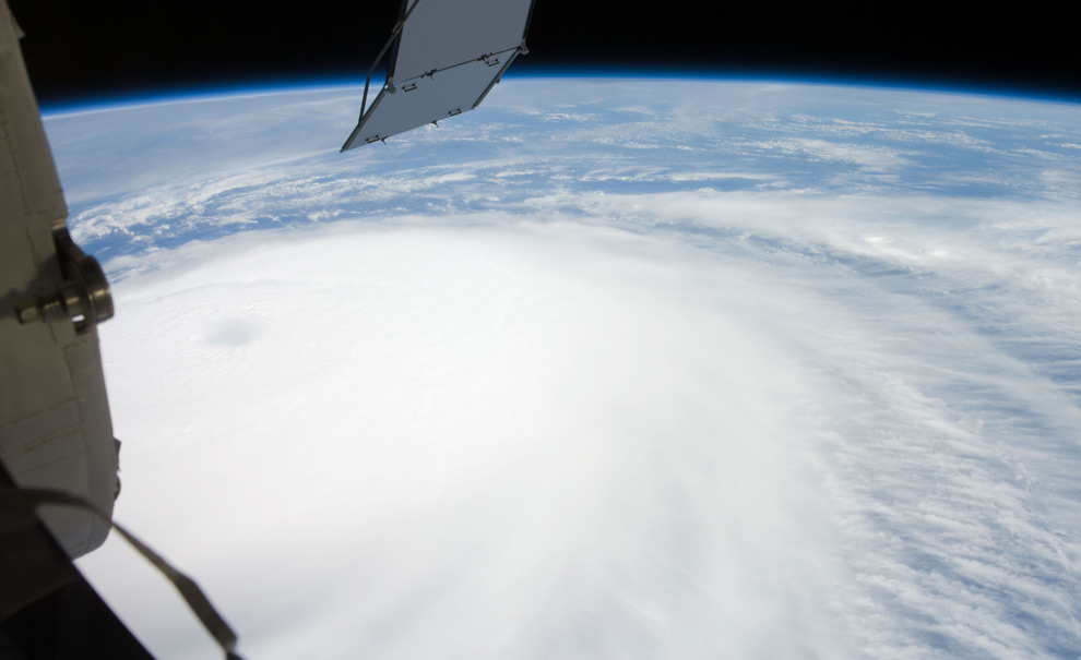
 Hurricanes, as seen from orbit
Hurricane Ike just rolled across Cuba, and soaked parts of Haiti - both regions still reeling from recent Hurricane Gustav. Ike appears to be weakening now, but is headed tward the Gulf Coast of the U.S., and may yet strengthen.
The crew aboard the International Space Station was able to take a photo of Ike from 220 miles overhead last Thursday - one in a long series of great NASA photographs of hurricanes from space. Here are some of the best, from the past several years. (25 photos total)


Additional photo's - just fantastic!
WEATHER NOTE
Hurricane Center Works with Google on Storm Surge Warning

Danger Zone
Americans may soon use Google to see whether their homes are threatened by a hurricane's storm surge, said the director of the National Hurricane Center (NHC) in March.
Storm surge, the massive wall of water carried inland by a hurricane, destroys homes in vulnerable coastal areas, and is a great threat to those who ignore evacuation orders.
NHC Director Bill Read said a planned program will pair a Google application with storm surge data that meteorologists have used for years. Together, the application and weather data will determine the flooding threat of any storm category.
"People can plug in their address and see at what level they are at risk," Read told the Reuters news service.
He said he hopes the program would be available in time for the Atlantic hurricane season, which begins June 1 and ends November 30.
Hurricane forecasters use a computerized model called SLOSH (Sea, Lake and Overland Surge from Hurricanes) that estimates storm surge heights by taking into account a hurricane's size, internal pressure, forward speed, track and wind strength.
The idea to make SLOSH models publicly available evolved from the phone calls that inundate local emergency managers and weather forecast offices every time a hurricane threatens: Read said people ask what flooding will be like at their homes.
"We're not going to know that off the top of our heads," he said. "So we can say, ‘Go to our Web site,' and it's there."
Hurricane forecasters will also offer a color-coded graphic this year on the NHC Web site, www.nhc.noaa.gov, that will indicate storm surge probabilities for threatened areas, similar to forecasts already available on wind speed probabilities. The graphic will indicate the probability of the surge reaching or exceeding 5 feet within a given number of hours, Read said.
It promises to help local emergency managers with key decisions, such as when to lock down bridges and what roads could be washed out or need to be cleared.
Students Still Iffy
Although text messaging systems have received much attention as a viable means of alerting students during a crisis, so far students have not embraced the idea, according to an Associated Press news report.
Hundreds of campuses have adopted text alerting (where students sign up for the alerts), but the enrollment rate among students and faculty is less than 40 percent, according to one provider of text alerting. According to another provider, enrollment was less than 30 percent.
Some students are concerned about giving out personal information, and others are indifferent, thinking a tragedy like last year's shootings at Virginia Tech will never happen to them. In fact, four in 10 students at Virginia Tech have still not signed up for text alerts, according to the report.
Experts said students will eventually gain confidence in text alerts, and they should be just one of many means of communicating with students and faculty.
Tower of Ash
In mid-March, a tower of ash rose hundreds of feet above the Kilauea volcano at Hawaii Volcanoes National Park, attracting residents and tourists who wanted to catch a glimpse of the first explosive eruption there in more than 80 years.
Because of a tenfold increase of sulfur dioxide emissions from the volcano, the state's health and civil defense officials were concerned about how the ash and gasses spewed from Kilauea may affect public health. Officials monitored the emissions and wind patterns just in case they moved toward the local population.
Another small explosion occurred on the morning of April 16, and civil defense officials advised nearby residents that sulfur dioxide levels "may be high enough to cause severe reactions [for] those in the sensitive groups, as well as those in the general population," the Honolulu Advertiser newspaper reported.
An evacuation center was set up at the Naalehu Community Center, but the county lifted the evacuation advisory when sulfur dioxide levels dropped.
Super Tuesday Tornadoes
What's being called the deadliest tornado outbreak in the United States in 20 years - which struck on Super Tuesday - took the lives of more than 50 people and injured hundreds.
Tornadoes and severe storms hammered the nation's midsection, sweeping through 18 counties in Tennessee, Kentucky, Mississippi and Arkansas on Feb. 5 and Feb. 6.
Tennessee was hit hardest, with 33 people dead, 189 injured and approximately 525 homes destroyed. Reports of winds up to 200 mph were reported, and damage to Union University in Jackson was estimated at $40 million.
The outbreak was the deadliest since May 31, 1985, when storms killed 76 people across Ohio and Pennsylvania.
MARITIME NOTESeafarer Honored for Risking Life in 24-Foot Waves to Save Drowning Man
 | ||||
Seafarers ([1] SIU) member John Dacuag put the extensive safety and rescue training he received from the union’s training center in Piney Point, Md., to good use in the middle of the Pacific Ocean and a typhoon when he jumped into the 24-foot seas to rescue a crewman from a sunken ship.
For his heroic efforts, Dacuag was awarded the Coast Guard’s Gold Lifesaving Medal, the Coast Guard’s highest civilian award, in a Honolulu ceremony late last month.
Dacuag was sailing aboard the U.S.-flagged cargo ship the Horizon Falcon in July 2007, when the ship received a distress call from another cargo vessel, the Hai Tong No. 7, which was about 375 miles northwest of Guam. The Horizon Falcon changed course and steamed toward the Hai Tong several hundred miles away.
But when the ship arrived the next day at the last known position of the Hai Tong, it found crew members in the water and oil slicks and debris from the sunken cargo ship. The wake of Typhoon Man-Yi was generating 24-foot seas and 40-mph winds.
On board the Horizon Falcon, Dacuag volunteered to try reaching a struggling Hai Tong crewman in the water. Climbing down a ladder on the Horizon’s portside, he attempted to reach the struggling man. According to the Coast Guard citation.
His lifesaving effort was particularly dangerous due to the severe weather, treacherous sea conditions and large amount of debris created by the passing typhoon and stricken vessel….Despite the grave risks to his own safety, Mr. Dacuag hung from the pilot’s ladder in 15–24 foot seas…he was submerged several times in water over his head.
Several times he was able to grab the man. But the winds, heavy seas and the ship’s movement broke his grasp several times. Then,
without consideration for his own life, Mr. Dacuag jumped into the extremely hazardous waters and swam to the survivor through 24-foot seas and attached the grappling hook and line to hoist the survivor on board.
Rescue efforts by the Horizon Falcon and Coast Guard search and rescue teams were able to save 13 of the 22 crew members.
At the awards ceremony, Rear Adm. Manson K. Brown said Dacuag’s
heroic daring demonstrates the absolute highest caliber of seamanship.
For more information on the SIU’s Paul Hall Center for Maritime Training and Education, where Dacuag took his rescue and training courses, click [2] here.
Man overboard fatality from the research survey ship Geosounder, 25 August 2007
Man overboard fatality from the research survey ship Geosounder, 25 August 2007. ATSB Transport Safety Report 246 on the independent investigation into the man overboard fatality from the research survey ship Geosounder which occurred about 185 miles north-east of Cairns, Queensland on 25 August 2007.
RS
























![[Valid RSS]](valid-rss.png "Validate my RSS feed")