Showing posts with label Meteorologist. Show all posts

Wednesday, December 3, 2008

Can China's Future Earthquakes Be Predicted?

Can China's Future Earthquakes Be Predicted?

ScienceDaily (Nov. 24, 2008)Ji ShaoCheng of the Université de Montréal's affiliated engineering school École Polytechnique is part of a team studying last May's devastating earthquake in China.

On May 12, 2008, at 2:28 p.m., China's Szechwan province changed forever. In the space of 90 seconds, an earthquake equivalent to 1,200 H-bombs pulverized the earth's crust for more than 280 kilometers. Entire cities disappeared and eight million homes were swallowed up. This resulted in 70,000 deaths and 20,000 missing.

Two months later, ShaoCheng arrived in Szechwan province to study the damage first hand. The extent of the damage was unimaginable: roads and bridges collapsed, schools turned into rubble, and bodies of men and women everywhere.

According to ShaoCheng this tragedy could have been avoided. "There hasn't been one earthquake in Szechwan province for 300 years. Chinese authorities thought the fault was dead," he says.

The problem is that China relied on GPS data, which showed movements of 2 mm per year in certain areas when in reality the shifts were much bigger. "GPS is high-tech, but do we really know how to interpret its data?," he questions.

ShaoCheng was recruited by one of his ex-colleagues with whom he completed his PhD in Montpellier and who now works for the Chinese Academy of Geological Sciences. His mission is to dig three narrow wells, 3-kilometers deep, into the earth's crust for a whopping $75 million.

"The drilling will allow us to see the characteristics of the rocks before and after the earthquake. We will also measure their thermal properties and fluid pressure," says ShaoCheng. "One of these wells will have a seismometer and another will be equipped with a device similar to a stethoscope designed to listen to the earth's heartbeat."

It is expected to take five years of hard labour to rebuild the devastated region.

WEATHER NOTE

Local Meteorologist Wins Big Award

Meteorologist Mark W. Rose was awarded the 2008 National Weather Association Public Education Award at the Annual Conference in Louisville in October. Mark is a meteorologist at the NOAA/National Weather Service Forecast Office here in Birmingham.

Mark was chosen for the award for the design, development and marketing of a nationally recognized weather safety DVD called “Surviving the Storm.” The program is geared to elementary school children and focuses on severe weather safety as well as the role of the National Weather Service.

Speaking to school groups is a critical part of the weather community’s outreach to the public about weather safety. Our very own James Spann is a leader in this area, speaking in a different school almost every day. Mark was frequently asked to speak in schools about severe weather. Of course, there are lots of schools and little time, which is frustrating.

His answer was to develop “Surviving the Storm.” He secured sponsor dollars to produce the DVD. Knowing that quality would be a key concern, he hired a professional company to do the production.

Distribution would be key. Mark contacted the Alabama Department of Education to get the DVD into schools. The state Emergency Management Agency came up with the money to duplicate the 1,000 or so DVDs that would be required. As a result, every school administrator at every public and private school in Alabama has the video.

Other organizations have contacted Mark about the video, including the National Weather Service in Memphis. The team there sent it out to all of its emergency managers. Other state Emergency Management Agencies have expressed interest in using the DVD, including Oklahoma. They called this week.

Mark, like most of us, has held a fascination with weather since childhood. The most interesting weather phenomenon to him is the thunderstorm.

He is a 22 year veteran of NOAA’s National Weather Service. He started as an intern at the NWS in Mobile. He transferred to the NWS Birmingham in 1989. He and his family live in Vestavia Hills. His wife works as the Curator for the Beeson Divinity School at Samford University. Their son is a freshman at Samford and their daughter is a high school junior. He is the President of the local National Weather Association chapter.

MARITIME NOTE

Skippers responsible for safety checks

25/11/2008 9:18:38

Boaties are being reminded to carry out simple safety checks before heading out onto the water in the wake of the tragedy which saw two children drown last year.

Auckland father Lindsay Rowles has been sentenced to 250 hours of community service after pleading guilty to operating a vessel causing unnecessary risk or danger.

Rowles' two children, eight-year-old Erina and five-year-old Travis drowned near Shag Island in the Hauraki Gulf when the aluminium boat they were asleep in started taking on water because a bung was not in place. The adults on board were unable to get the children out of the cabin when the boat hit rocks and quickly sank.

Jim Lott from Maritime New Zealand says the agency will again be reinforcing its national safety strategy this summer. He is reminding boaties to always wear life jackets and inform others straight away when difficulty arises. Mr Lott believes about 70 percent of all fatalities on the water could be prevented if those points were adhered to.

Mr Lott says at the end of the day it is the skippers' responsibility to ensure the safety of passengers and crew.


RS

Wednesday, September 12, 2007

Annual Call for SKYWARN Footage


This was a decent severe weather year for most of us --with possibly more nasty weather yet to come. Many of you are now working on/thinking about your highlight reels. I figured now would be a good time to announce my annual "call for SKYWARN video" a little early while you are spending time with the *raw* footage. My free classes would not be possible without the generous contributions of footage from storm chasers, spotters, EM, ham radio, and the media. Each year I search for fresh footage of weather-related phenomena to help get people more excited about attending the training / re-training.

Further, I'm on the look out for never-been-seen footage of unique events such as lightning strikes, accidents, flood rescues (there have been a lot of these lately), tornadoes causing damage, and giant hail. I'm talking about eye-opening video which helps drive the safety points home and maintain interest in a dark crowded room.
Most chaser highlight videos contain a lot of tornado footage. That's good for entertainment and research but not necessarily the best material for spotter training since the majority of what spotters really see (and get confused about) is non-tornadic. Therefore the footage you may be thinking of discarding from your highlight reel often turns out to be the best material for training. So what am I looking for? Well put yourself in the position of a new spotter.

This might be a 14 year old girl or a 50 year man old who's suddenly become interested in severe
weather after a recent close call with a tornado. These are folks who likely have little or no exposure to severe weather training outside of what they've seen on TWC/TLC/NGC. What kinds of things do you think these folks might need to know to operate safely around storms and make meaningful and accurate reports? Now consider the people who have attended several (perhaps dozens) of SKYWARN classes. You know, the folks snoring in the back of the room! What kind of material do you have which might help teach these "old dogs" some new tricks? Ask yourself this. Have you seen spotters make the same bad calls or dumb mistakes over and over and you've said to yourself "what's the matter with these morons?" Most people aren't morons they've just haven't received adequate training and reinforcement. It's the "old dogs", whom many new spotters look up to for training and reassurance, that pass on valuable experience as well as misinformation.

Therefore these folks need to be reached too.
When I look for footage I prefer DVD or mini-dv tapes but being that I work in broadcast TV I have access to all formats of players. I prefer raw, unedited, footage. That means you don't need to clean up the jump cuts, remove swear words, or add cheesy music Please no cheesy music).

It's helpful your footage includes the date, approximate time, location, and (if you can remember) the direction you were looking. I use this information to match up with archival satellite, radar, and surface data to give a more full picture. I am especially interested in events where multiple chasers got footage of the same event from different angles.
For example, I shot some nice footage of tornadoes in Protection, KS this year. Later at Rocky's chaser party I saw some great close-up footage of the same tornado. As I chaser I'd say the close-up footage was the best but as a spotter trainer I'd say both scenes were equally important since not every spotter will be 1/4 mile away or be looking at a back-lit tornado free from obstructions, and facing west. It's the not so obvious stuff like a developing tornado with no condensation funnel that spotters need to know about.

It's the stuff that looks like a tornado but is not that spotters need to know. It's the situations which appear safe but are in fact are very dangerous (like Greensburg at night) that spotters need to know how to deal with.
So if you have any footage of weather phenomena, safety-related issues (good and bad), reporting techniques (good and bad), measurement techniques, and spotter gadgets I sure could use it. As always I provide on-screen credit for people who provide footage. I once included people's names on every shot but this was a real hassle in editing and also proved really distracting to the viewers. When people ask specific questions about whose footage they just saw I provide them with the name of the contributor. It should be noted that I do these classes as Chris Novy, amateur radio operator/EM trainer. My classes are not affiliated with my TV station employer so I encourage you media folks on WX-CHASE to consider contributing station-obtained footage.

News crews often get the best footage of really dangerous people tricks. You have my guarantee that your footage will not appear on my TV station or be part of any weather-related productions outside the immediate scope of my live classroom talks. I've been doing this a long time and have a reputation with the chasing community to keep.
Last year I started sharing (with permission of the contributors) footage with NWS OUN.

I would like to offer this service again--either by 1) offering to make an exact copy of any footage you send me, 2) having interested NWS offices who have seen the footage you provided me with contact you directly for a copy, or 3) by compiling an edited down "SKYWARN essentials" DVD which contains scenes and supporting raw data to be used in NWS SKYWARN training. Such a DVD would contain no narration and no music.

I would probably burn the name
of each contributor on the video since I would not longer be in direct control of the video once it's left my hands and I want your assets to be protected. Here, NWS offices could digitize specific scenes of rain, hail, tornadoes, etc. as *they* require for their own unique training needs. I'm really interested in comments about the DVD idea and whether its release should be only to NWS offices or should also include organized EM and ham radio groups which do their own training. I've been asked about producing a complete training DVD but honestly I feel it's better for people to attend a SKYWARN class, mine or NWS, where they can interact with the instructer and learn from others at the presentation.

It's like saying "here's a book about how to do CPR" instead of encouraging someone to take an actual class.
Thanks again for your support. Please contact me off-list (chris@siu.edu) if you have footage you are willing to donate and also let me know if and how it can be shared with NWS.

If you think I (or someone else in the group) should put together a "SKYWARN Essentials" raw footage DVD for NWS purposes let's discuss this openly on WX-CHASE. I am willing to reimburse people, if needed, for postage but since I'm not operating under a grant and I don't play the lottery I have no funds for purchasing video.


Again thanks.
..
Chris Novy.. WA9V Yukon, OK

Maritime Notes:

Here is one for kicks! "
Bad weather conditions are being blamed both for the grounding and delays in getting her refloated" Yeah I would consider a Cat 5 Hurricane bad weather...


Maersk container ship runs aground
Mexican press report grounding of MAERSK DIADEMA

A MAERSK operated container-ship grounded outside the Lazaro Cardenas container terminal in Mexico, reports local press.

The incident happened on Saturday, according to Maersk and press reports. Bad weather conditions are being blamed both for the grounding and delays in getting her refloated.

A customer advisory on the incident, apparently published yesterday, by Maersk appeared to indicate that attempts would be made to refloat her, and it would appear these have so far been unsuccessful

The vessel does not seem to be damaged and power to her refeers is still maintained, according to Maersk

The local press claim that the vessel's grounding was suppressed by port officials initially and that a 'lesser employee' confirmed the story later.


The MAERSK DIADEMA is on charter to Maersk (initially chartered to P&O Nedlloyd before the merger with Maersk) and is actually the CHARLOTTE WULFF built for the German firm of Reederei Hermann Wulff at the Stocznia Gdynia S.A shipyard in 2005.

She was delivered with her Maersk name after being secured to an eight year charter with P&O Nedlloyd.

RS


Friday, September 7, 2007

Stronger Hurricanes Mean Whopper Waves

Larry O'Hanlon, Discover News

July 26, 2007 — Three decades of data about ocean waves, collected from buoys off the U.S. Atlantic Coast, shows waves are getting steadily larger in response to stronger hurricanes. The discovery offers a new way to spot trends in hurricane intensities — a subject of intense controversy.

Since 1975, hurricane-spawned waves have grown 2.3 to 6 feet higher.

"It probably has something to do with global warming," said oceanographer Paul Komar of Oregon State University.

Komar and his colleague Jonathan Allan analyzed the Atlantic waves after seeing a similar rise in heights in buoy data from the North Pacific. Their latest work is summarized in a short report in the July 24 issue of the journal Eos.

Global warming is a suspected cause of the North Pacific wave heights rising as well, although it could also be the effects of pollution from China, Komar said.


Discovery News' Kasey-Dee Gardner gets inside a hurricane simulator.

In 2005, MIT hurricane researcher Kerry Emanuel reported that hurricanes in the Atlantic were intensifying. But some researchers have disputed Emanuel's data, because it is derived from storm wind velocity measurements over several decades.

Emanuel's critics are suspicious that the perceived intensification may be only a mirage created by trying to translate and combine so many kinds of data from the changing technologies used to monitor storms.

Wave data, on the other hand, suffers from no such problem. Buoys work basically the same today as in the 1970s, said Komar.

"The technology for measuring waves has not changed," Komar told Discovery News. "So it's a consistent record. It led me to the conclusion that Kerry Emanuel is correct."

Making the buoy wave data even more rigorous is the fact that the buoys are anchored at fixed positions, points out oceanographer Robert Dolan of the University of Virginia.

Dolan agrees that the wave data seem to confirm Emanuel's assertion that hurricanes are getting stronger. However, more information would be nice, over a longer period, to confirm the trend.

"We're talking about a rather modest increase," Dolan told Discovery News. It's not exactly the sort of increase that will get coastal planners excited, he said, unless they are very far-sighted.

It would also be useful, said Komar, if someone would undertake the arduous task of looking at the wave data, storm by storm, to really learn how the two are related.

"Just the study of these waves will lead to better understanding of impacts on coasts and help project into the future" in which more big waves and higher sea levels are expected, Komar said.

RS

Friday, August 31, 2007

SMURFING (SFRM) HURRICANE DEAN

"Smurfs" Vs. Hurricane Dean

WIRED
By David Axe

August 19, 2007 | 9:54:06 PM

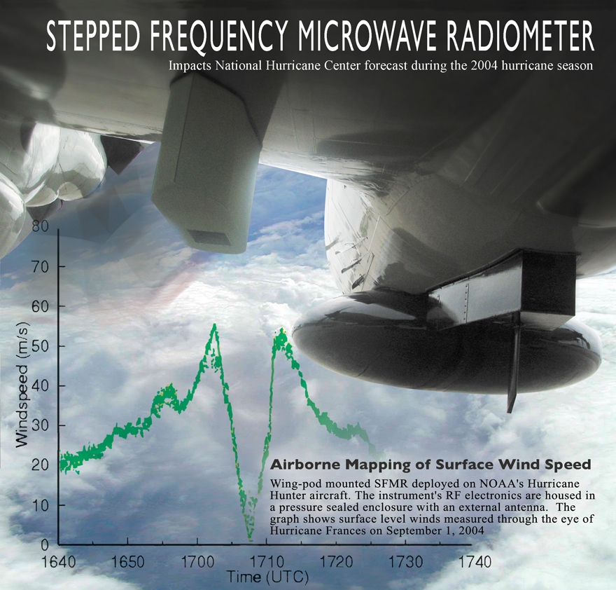
Two years ago Hurricane Katrina kicked the U.S. government's ass. Now, as Hurricane Dean sweeps past Jamaica on its way to the U.S. Gulf Coast, FEMA, the Coast Guard and the other military services are poised to prove they can do better the second time around. The military response actually began days ago when the Air Force's WC-130J hurricane-hunting patrol planes deployed brand-new sensors to more accurately predict when and where Dean will hit and what kind of damage it will do, according to the service. The "Stepped-Frequency Microwave Radiometer," or "smurf,"

allows the Citizen Airmen of the Hurricane Hunters to constantly measure surface winds directly below the aircraft. The smurf can also determine rainfall rates within a storm system. This, in addition to wind speeds at flight level, provides structural detail of the storm. "The SFMR will be the biggest advance I can think of to improve hurricane intensity forecasts," said Max Mayfield, former director of the [National Hurrican Center].

The data collected by the Hurricane Hunters increase the accuracy of the NHC forecast by 30 percent, a rate which will undoubtedly increase with the use of the smurf. This data enables the NHC to more accurately predict the path of storms in order to save lives and narrow areas of evacuation, according to NHC forecasters.


U.S. Air Force Fact Sheet

STEPPED-FREQUENCY MICROWAVE RADIOMETER
SFMR Ready for 2007

PURPOSE:

The Stepped-Frequency Microwave Radiometer is a state-of-the-art instrument designed to continuously and accurately measure the winds at the ocean's surface directly below the aircraft. The SFMR, affectionately known as "smurf", is installed on the WC-130J within a pod attached to the aircraft's wing. As the plane flies through a storm, the SFMR senses microwave radiation naturally emitted from foam created on the sea by winds at the surface. Computers then determine wind speeds based on the levels of microwave radiation detected. Currently, winds are extrapolated from the winds at the aircraft's altitude or from a dropsonde released from the aircraft, however, the SFMR directly measures the surface winds and is not confined to a single point like the dropsonde. This constant measurement of surface winds gives the National Hurricane Center a more complete picture of the storm.

The SFMR can also determine rainfall rates within a storm system. This, in addition to wind speeds at flight level, provide structural detail of the storm.

Two Hurricane Hunter aircraft will be equipped with the SFMR by the end of June with one added each month until all 10 WC-130J aircraft are outfitted with the SFMR pod, the last to be equipped in March, 2008.


Hurricane Hunters fly year's first storm mission over Atlantic


SPECIFICATIONS:

Radiometer Type Hatch
Tuning bandwidth 4.6 -7.2 GHz
Number of channels Up to 8
Receiver Channel Bandwidth 50 MHz
Antenna Type Corrugated horn
Antenna Beamwidth (3 dB) 20-28 deg Polarization Linear
Measurement precision 0.17 K (1second averaging)
Electronics Power Requirements 28VDC, 2A
Thermal Control Power Requirements 28VDC, 4A (max)
Power 168 W
Operating Temperature -65°C to +40°C
Humidity 0 to 100%
Size (L x W x H) 24" x 11" x 13"
Weight 40 lbs.


WP-3D Stepped Frequency Microwave Radiometer (SFMR)


Measurement of the hurricane surface wind field, and in particular the estimation of wind maxima, has long been a requirement of the Tropical Prediction Center/OAR. The NOAA/Hurricane Research Division's Stepped-Frequency Microwave Radiometer (SFMR) is the prototype for a new generation of airborne remote sensing instruments designed for operational surface wind estimation in hurricanes.

The SFMR has a downward pointing antenna which passively reads the microwave radiation coming from the ocean surface. By making assumptions about the vertical structure of the atmosphere together with sea surface temperature measurements by a downward-looking airborne infrared radiometer, reasonable estimates of the ocean surface brightness temperature can be made at six frequencies between 4.6 and 7.2 GHz. Wind speeds are then calculated assuming linear increase in wind speed with these brightness temperatures. Since some of the frequencies are more attenuated by rainfall than others, an estimate of the rainfall rate below the airplane can also be made.

Project page for SFMR development
Report on SFMR in Katrina and Rita 2005


Weather Story:

Well we have Tropical Storm Gil and Tropical Depression ELEVEN E (RESOE EDIS) off the Pacific Coast that we are keeping an eye on. There are also a couple of interesting tropical waves forming off the African Coast (see Tropical Weather Outlook and Storm Watch-Carib interactive graphics- left side of page)!

Chicago Weather for the weekend? Just great! Have a wonderful Labor Day Weekend!

RS


Thursday, July 26, 2007

Survey of Hurricane Preparedness Finds One-Third on High Risk Coast Will Refuse Evacuation Order

Many Could Face Shortages of Food and Water

Most New Orleans Residents Do Not Know Location of Evacuation Shelters

For immediate release: Tuesday, July 24, 2007


Boston, MA --According to a new survey of people in high-risk hurricane areas conducted by the Harvard School of Public Health Project on the Public and Biological Security, one-third (31%) of residents said if government officials said they had to evacuate due to a major hurricane this season, they would not leave. This is an increase from 2006 when 23% said they would not evacuate.

Hurricane Sign (iStock_000003658320Small.jpg)

The survey was conducted in eight states—Alabama, Florida, Georgia, Louisiana, Mississippi, North Carolina, South Carolina and Texas—and only included residents of counties within 20 miles of the coast. The poll included a special sample of the New Orleans metropolitan area (Figures 1 and 2).

The top reasons people give for not evacuating involve issues of safety and security. Three-quarters (75%) say their home is well-built and they would be safe there. Over half (56%) feel that roads would be too crowded, and slightly more than one in three (36%) feels that evacuating would be dangerous. One-third (33%) worry that their possessions would be stolen or damaged while one in four (27%) say they would not evacuate because they do not want to leave their pets (Figure 2).

“Public officials need to be concerned that the further we get from the severe hurricanes of 2005, the less willing people are to evacuate,” said Robert J. Blendon, Professor of Health Policy and Political Analysis at the Harvard School of Public Health. “Officials need to remind people that many homes are vulnerable to major storms. They also need to ensure safe evacuation routes are available and the public is aware of them.”

These findings are based on interviews conducted June 18 - July 10, 2007 with 5,046 adults in high hurricane risk counties in eight states.

The complete survey and charts with figures are available here

Individual state data here

The results of this survey will be distributed to state and local officials for use in emergency planning.

Evacuation and Shelter Conditions
If residents of high-risk hurricane areas have to evacuate because of a major hurricane, most would be concerned about the conditions of evacuation shelters if they had to go to one. The biggest worries people have are that shelters would be unsanitary (68%), there wouldn’t be enough clean water to drink (66%), the shelter would be too crowded (65%), they would be exposed to sick people (62%), and medical care would be lacking (58%).

Hurricane Preparations
Many residents of hurricane-prone areas have not made critical preparations for a major storm. If running water were cut off due to a hurricane, one in four (23%) would run out of clean water after two days, and over half (54%) would run out after six days. If power were shut off, one in ten (9%) would be without food after two days, and nearly half (44%) after six days (Figure 3).

Hurricane Katrina showed that families can get separated and communication can break down in the aftermath of a major storm, but most residents have not prepared for that possibility. Two in three (66%) have not agreed on a meeting place if their family is separated, and one in two (49%) have not agreed on a phone number outside the region that family members could call. Of those who intend to evacuate and need help to do so (13%), half (50%) do not have that help lined up (Figure 3).

Key Preparedness Information
Past experience with hurricanes has identified some critical information that people should know in order to be prepared for a storm. Many residents of high-risk areas were unaware of some key information. One out of three (34%) do not know if their home is located in an evacuation zone. Thirty-nine percent do not know the location of an evacuation center in their community where they could go if they had to (Figure 4).

A large majority of people would be at risk of eating food that has spoiled due to a loss of refrigeration in a power outage. The USDA recommends that perishable food should not be eaten if refrigeration has been turned off for four hours. Only one in five (20%) knew that perishable food would be safe for just a few hours. One in three (36%) said that food is safe for up to one day, one in four (25%) said two days, and 16% said three or more days. In addition, one in five did not know that each household member requires at least one gallon of clean water per day, the amount recommended by the CDC.

Hurricane Palms (iStock_000000510427Small.jpg)Problems During Past Hurricanes
Nearly one-half (46%) of the respondents in the survey live in communities that were damaged by a hurricane during the past three years. The survey asked them about the problems they had during these hurricanes in order to identify issues that could be prevented in future hurricanes. The most common problem was getting gas to evacuate (35%). Twenty percent reported they did not have enough money at some point, 14% did not have enough water and 12% did not have enough food. Of note, smaller numbers reported needing medical care but not getting it (5%), getting injured (5%) or being threatened by violence (3%) (Figure 5). One area where few people reported problems was getting the information they needed to keep themselves and their families safe (8%).

New Orleans
The survey included a sample of the New Orleans metropolitan area to see if residents there differed from other high-risk area residents. After their experiences during Hurricane Katrina, most New Orleans residents say they would evacuate for a future storm. Only 14% would not evacuate compared to 32% of residents of other high-risk areas. Six in ten (61%) do not know the location of an evacuation shelter if they needed to go to one, which is significantly more than residents of other areas (38%). Despite the dramatic images of people stranded during Katrina, over half (54%) of New Orleans residents are confident they would be rescued if they needed to be during a future storm (Figure 6).

“It is worrisome that New Orleans, the site of one of the most severe hurricanes in U.S. history, has such a large proportion of people who don’t know the location of an evacuation center,” said Professor Blendon. “An important priority for government and voluntary agencies should be to inform people of the location of shelters well before a storm hits.”

Even after Katrina, a substantial percentage of New Orleans residents are not prepared for a major storm. One-half of New Orleans residents (51%) have not agreed on a place for family to meet if they get separated. Thirty-nine percent have not agreed on a phone number outside the region that family members could call. A sizable percentage of New Orleans residents (23%) do not have more than two days of water if the water supply were cut off.

When asked to rate the response of government and voluntary agencies to the problems created by the last major hurricane, 78% percent of New Orleans residents said it was fair or poor compared to 39% of residents of other areas damaged by a hurricane. Only 19% of New Orleans residents said the response was excellent or good compared to 57% in other areas.

Problems Facing Minorities and Low-Income Residents of High-Risk Hurricane Areas
Hurricane Katrina illustrated the additional challenges facing minorities and the poor in these high-risk coastal areas during a major hurricane. This survey finds that although African-Americans (73%) and Latino-Americans (71%) are more likely than whites (59%) to say they would evacuate if government officials said they had to leave in the event of a major hurricane, they are also more likely to need help to do so. Seventeen percent of African-Americans and 10% of Latino-Americans say they need help to evacuate and do not have that help lined up compared to 3% of whites (Figure 7). Low-income residents also would have more problems evacuating than those who are better off financially. Eighteen percent of those making less than $25,000 a year and who intend to evacuate do not have the necessary help compared to 4% of those making $25,000 a year or more.

If minorities and low-income residents are unable to evacuate because they do not have help, they are less prepared to stay in their homes and weather the storm and its aftermath. Approximately one-third of African-Americans (32%), Latino-Americans (35%) and low-income residents (33%) say they are not prepared if a major hurricane were to strike their community in the next six months. This compares to 14% of whites and 19% of those making $25,000 a year or more. A greater percentage of African-Americans (18%), Latino-Americans (11%) and low-income residents (14%) do not have enough food on hand to last more than three days compared to whites (6%) and those making $25,000 a year or more (8%).

Methodology
This is the 25th in a series of studies by the Harvard School of Public Health Project on the Public and Biological Security. The study was designed and analyzed by researchers at the Harvard School of Public Health (HSPH). The project director is Robert J. Blendon of the Harvard School of Public Health. The research team also includes Tami Buhr, John M. Benson, and Kathleen J. Weldon of the Harvard School of Public Health, and Melissa J. Herrmann of ICR/International Communications Research. Fieldwork was conducted via telephone for the Project by ICR/International Communications Research of Media (PA) between June 18 and July 10, 2007.

The survey was conducted with a representative sample of 5,046 non-institutionalized adults ages 18 and over in high hurricane risk counties in eight states. Survey participants included residents of all counties within 20 miles of the coast in Alabama (503 interviews), Florida (1,006), Georgia (506), Louisiana (1,004), Mississippi (513), North Carolina (504), South Carolina (507), and Texas (503). The survey included 502 residents of the New Orleans metropolitan area, where interviews were conducted with adults from cellphone-only households, as well from households with landline telephones.

The results were weighted to represent the total adult population in the high hurricane risk counties of the region as a whole. The margin of error for the total sample is plus or minus 2.6 percentage points; for the New Orleans-area sample, plus or minus 4.7 percentage points.

Possible sources of nonsampling error include nonresponse bias, as well as question wording and ordering effects. Nonresponse in telephone surveys produces some known biases in survey-derived estimates because participation tends to vary for different subgroups of the population. To compensate for these known biases, sample data are weighted to the most recent Census data available from the Current Population Survey for gender, age, race, education, as well as number of adults in the household. Other techniques, including random-digit dialing, replicate subsamples, callbacks staggered over times of day and days of the week, and systematic respondent selection within households, are used to ensure that the sample is representative.

The Harvard School of Public Health Project on the Public and Biological Security is funded by the Centers for Disease Control and Prevention through a grant to the Association of State and Territorial Health Officials (ASTHO). HSPH provides ASTHO and the CDC with technical assistance for public health communication by monitoring the response of the general public to public health threats.

For further information contact:

Robin Herman rherman@hsph.harvard.edu 617-432-4752 or
Todd Datz tdatz@hsph.harvard.edu 617-432-3952.

Monday, July 23, 2007

Forecasting Dangerous Waves

Lets meet another brand of storm chaser. Unlike the ones we see chasing tornado's, these storm chasers are chasing something we normally do not see right away and that causes havoc and hell on water.

We have talked about rogue and dangerous waves. I have and will continue to post some extraordinary pictures and videos of these waves and what they can do to ships, cargos and lives. Today I want to talk about the potential of forecasting dangerous waves. This would be indeed a ma jor advancement and benefit to both meteorology and the maritime communities.

The study of rogue waves is just getting underway. As I have noted Dr. Paul C. Liu of NOAA's Great Lakes Environmental Research Laboratory (GLERL) has been studying these waves. GLERL has also been studying wave forecasting for the Great Lakes Region.

According to GLERL, " This project is designed to develop and fully implement a system of computerized models that can simulate and predict the three-dimensional structure of currents, temperatures, water level fluctuations, wind waves, ice, and sediments in the Great Lakes. The project will integrate these models with the required observational data systems into a real-time coastal prediction system. The project will make the information developed from this system available in a useful format and in a timely fashion to National Weather Service (NWS web site) forecasters, coastal users and resource managers".

NOAA/NWS has both a Ocean Prediction Center and Wavewatch III . But neither of these services accurately report on waves inside the Gulfstream. Why is this important? Currents or "moving water" play a important role in both effecting and determining dangerous waves. Why don't they report? Well its complex, they can to some degree but the technology is also not there yet to satisfy the powers to be. Maybe NOAA should consider this rather than spend $100 million on public relations? So lets take a look at another concept being proposed in wave forecasting called the; Gulfstream Hazard Scale, by professional satellite Oceanographer Jenifer Clark and husband Meteorologist Dane Clark.

In a letter date 18 July 2007 to the Director of the National Centers for Environmental Prediction, the Clark's state, "
We have become increasingly alarmed by the large numbers of vessel sinkings and loss of life and property in the Gulfstream along the U.S. East Coast over the past several years. Just this spring, four more boats were sunk and four people were killed during an east coast storm that later became Tropical Storm Andrea -- even though this system was well forecast by NWS forecast models."

After talking with hundreds of mariners who have sailed in these waters over the years and recently completing a research report for a court trial involving the cruise liner "Norwegian Dawn", which was severely damaged with 400 passenger injuries in April 2005 after encountering 40-70 foot steep waves in the Gulfstream; we have concluded that mariners are not being adequately warned about the pote ntial danger when strong winds oppose strong ocean currents in the Gulfstream System (the main Gulfstream and eddies).

In the case of the Dawn, the Captain of that vessel testified that they had no idea they were sailing into those horrific conditions (see attached graphic). NWS forecasts indicated strong winds to 50 kts and significant wave heights to 27 feet, which were good forecasts outside the Gulfstream, but in the Gulfstream, seas were more than double that and these waves were much steeper and more difficult to navigate. Notations in the marine forecasts indicating "waves higher in the Gulfstream" were not very useful and mostly ignored since they are repeated in many offshore forecasts on a daily basis and contain no actionable data the mariner can use regarding the height or danger of these waves and their exact location.

Based on these and other cases we have examined, we feel that improvements are needed to alert mariners about specific threats about extreme and dangerous waves that exist in Gulfstream waters during these severe weather events,
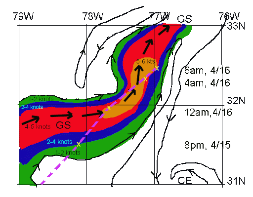
The highest risk area corresponds to the area of maximum ocean currents flowing northward (estimated at 5 kts) and winds recorded on the Dawn between 4-6AM on 4/16 at 50-55 kts blowing from the north. This is where an estimated 60-80 foot wave struck the Dawn and caused most of the damage and injuries. Wave heights were observed to be as high as 40-45 feet through the Gulfstream waters that night before the larger, steeper wave hit the ship.

Recent international research efforts to examine extreme wave events, termed MaxWave, have concluded that dangerous extreme waves are much more common than historically believed (and not uncommon, as the terms "freak wave" and "rogue wave" would imply). The studies further stated that current technology is incapable of precisely forecasting these extreme waves at present, but that there are areas around the world that are known "hot-spots" for extreme waves, like the Gulfstream, where strong winds often oppose strong ocean currents.
".


(Route ( chart above ) of the Norwegian Dawn (purple) on April 15-16, 2005 superimposed on Jenifer Clark's high resolution Gulfstream Analysis. The gulfstream maximum current is indicated by large black arrows, isolines of the estimated magnitudes of ocean currents are color coded and small arrows indicate the direction of flow of all ocean currents on this meso-scale chart.)

Therefore, using our experience and information from other mariners, we have developed a Gulfstream Hazard Scale which is similar to other environmental scales (tornados, hurricanes, river rafting, avalanches, etc.,) used to educate, alert and warn.

An important aspect of this scale is the increased potential for extreme waves, as the scale increases from Cat 0 to Cat 8. These are correlated to specific recommended responses to the risk, or threat levels.

This scale is a concept and has not been used operationally. Since it is subjective in nature, we expect that modifications may be needed before it could be used to develop warning products. The most important parameters required are detailed, real-time ocean surface currents in the Gulfstream area (Jenifer has been doing this on a daily basis for nearly 30 years) and real-time and forecasts of meso-scale surface winds (available from the NWS models).

We would like to sit down with your staff and discuss the possibilities of the NWS using this scale (or a modified version) in your operations, possibly on a trial basis next year. We envision a graphical product similar to the Mariner's 1-2-3 Rule for Tropical Storms, to warn mariners of high risk areas in the Gulfstream during severe conditions. This type of precise warni ng, containing risk levels for exact locations and times, should greatly improve the mariner's ability to understand and perceive the danger. This should in turn, motivate the Captain/Navigator to avoid these threat areas, resulting in reductions in life and property losses."

As you can read in the Clark's letter and as I have pointed out in some of my past posts, the Hatteras Trench region is a very well known maritime grave yard due to the storms fueled by the gulfstream and its winds. As we can read in their letter, we do have a hole in assisting mariners in forecasting these events. Some of the factors involved in the proposed Gulfstream Hazard Scale will include;

CAT - Categories 0-8, Risk - Threat to vessels from extreme or dangerous waves -- WD/OP/CUR - wind opposing the current. DUR - duration and fetch of the wind. SIG/WV/HGT - significant wave height (as per the international definition) -- an average maximum of the highest third of the waves in the wave spectrum, X/WAVS - Extreme wave potential, Marine/Guide - situation and recommended actions per category, (*) - generally taken as surface winds blowing against or quartering against the flow of the gulfstream currents (main stream or eddies).

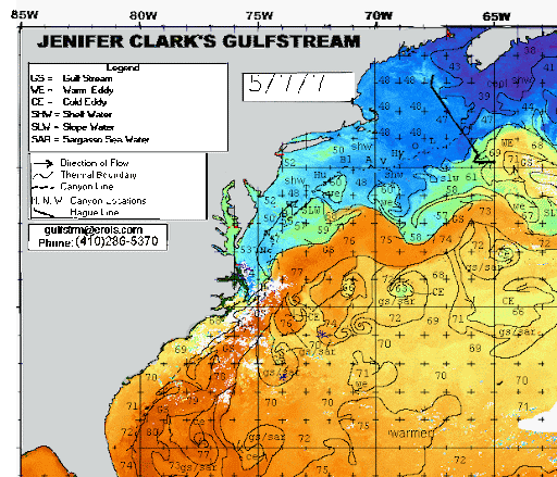
Note in the graphic above the stream encompasses both the main core (corps) and the eddies, something many mariners sometimes forget or just ignore. Now take a look at the cold eddies (below) during the 7 May 2007 Substropical storm andrea, when the s/v Sean Seamour II ran into trouble. Being able to predict the type of waves that the Sean Seamour II ran into, could have saved the sail boat from destruction and the crew from any hardships.


Also note the opposing winds to current from both northern quadrants . Remember strong winds in one direction with strong currents in the opposite direction can produce some very strong and active waves. Though some studies have shown that strong winds blowing from any directio n over gulfstream currents can also cause dangerous wave actions.

Its really this simple. Strong winds, strong currents, over time, means, very large waves. Its about being able to warn mariners in advance about these waves that can save ships, cargos and especially lives.

For further information on the Gulfstream Hazard Scale please visit,
Jenifer Clark's Gulfstream.

RS

Thursday, July 19, 2007

Second in a Series; Subsea Atmospheres

To continue my series on the topic of subsea atmospheres. Not only will we focused on underwater weather systems of our oceans, but also how subsea atmosphere's extend and effect our bays.

To continue with my series here is a interesting article titled;

Predicting Underwater Weather,
By Michael W. Fincham,


There's a weather under the Bay, complete with high-pressure systems, low-pressure systems, several kinds of fronts and two kinds of slow-moving jet streams. Think of physical oceanographers as meteorologists of this underwater world. As they figure out the physics that controls the system, they should be able to predict the underwater weather more accurately - and take a lot of guesswork out of the forecasting game that so many people have to play.

Like a band of robots, CBOS buoys stand watch over the Bay. Some stay on station year after year, like the one off the Choptank River. Others come and go, moved to monitor a particular area, or pulled for fear of ice. Shown on the map are a string of buoys, some on station and some still proposed, waiting for the region's next investment in remote sensing. Artwork by Bill Boicourt.

Those were the selling points when Chesapeake Bay Observing System (CBOS) began - better physics and better forecasting. Over the last 15 years, Bill Boicourt has kept the system running despite hurricanes, lightning strikes, icy winters, vandalism and up-and-down funding cycles. Funding so far has come from more than three dozen sources. That's a lot of grant writing, but it has allowed Boicourt to keep buying new buoys, rebuilding old ones and restocking them with the latest in advanced sensing gear. In years of good funding he's had seven buoys taking data simultaneously.

Physics and forecasting, according to Boicourt, are still the selling points for CBOS-like systems expanded to cover the entire Bay and the Mid-Atlantic coastal waters. CBOS may soon morph into a newer, larger network of buoys and land-relay towers, capable of relaying even more real-time data about the weather above and below the Bay. The results could boost Chesapeake Bay science and help protect the Maryland economy.

If the future arrives according to Boicourt's forecast, CBOS could evolve into a cooperative regional system with more stable funding and more partners from academe, state and federal government, and private corporations. Players could include the Virginia Institute of Marine Science (VIMS), Old Dominion University, the Environmental Protection Agency, NOAA's National Ocean Service, the U.S. Navy, the U.S. Coast Guard, the Alliance for Coastal Technologies, and state agencies in Maryland and Virginia. The result would be a cooperative system, perhaps with a new name, that would provide real-time weather and water data from the head of the Bay all the way out onto the Continental Shelf.

There are even larger plans afloat. Congress is now considering a proposal for funding and expanding systems like CBOS and linking them together into a larger coastal network. That could mean more money and more acronyms. CBOS might be renamed and linked into something called IOOS (Integrated Ocean Observing System) or C-GOOS (Coastal Global Ocean Observing Systems), both of which would be part of an overall system called GOOS. Those plans drew a major endorsement last week in the Preliminary Report of the U.S. Commission on Ocean Policy.

The science prize is long-term data that oceanographers can use for figuring out the physics of the Bay and other coastal systems in greater detail. Better forecasts are also in those details, especially details about water temperatures, winds on the Bay, waves and currents that result from those winds.

The practical prizes are real-time products forecasting what the system is doing today and tomorrow. That's important for big commercial shippers who need to know water levels up in Baltimore Harbor and small recreational boaters who want to know wave conditions out on the mainstem. Real-time models of current flows would help with search-and-rescue missions and with emergency responses to natural disasters like storm surges and human accidents like oil spills and chemical leaks. CBOS can even help with Homeland Security with high-frequency radar that helps track large and small ships as they move about the Bay.

In my next installment we are going to talk about a new potential concept that will help warn mariners of large and dangerous waves. The Gulfstream Hazard Scale. Under development by a Oceanographer and Meteorologist, Jenifer and Dane Clark.

RS