Showing posts with label tropical cyclones. Show all posts

Thursday, May 15, 2008

Burmese officials selling emergency aid supplies in local markets

Burmese officials selling emergency aid supplies in local markets

Officials in Burma's cyclone-hit Irrawaddy delta area are appropriating emergency aid supplies and selling them in local markets, it was claimed on Monday.

Burmese volunteers who are operating their own private aid missions to the area have said that they are having to hide from local apparatchiks in order to prevent them commandeering their aid and selling it on at markets.

The Telegraph learned of the alleged scam from a Burmese businessman from Rangoon, who was leading one of dozens of private relief missions distributing supplies of rice, biscuits and clothing around the flood-hit delta area on Monday.

The volunteers had covered the back of their pick up truck with a tarpaulin so that local officials could not see what they were doing.

"If they see our relief supplies, they will come over and say 'don’t worry, give that to us, we will distribute it for you',” he said.

"But we know that for every ten sacks of rice we give them, only four will reach the people.

"The other six will end up being sold by that official on a market in some local town. Rice prices are very high right now and that official will then make a good profit.

On the outskirts of the more storm-damaged regions, checkpoints had sprung up overnight, where police and immigration officials were banning any foreigners - including aid workers - from entering the area.

"We have orders to turn all foreigners around," said one official.

"That includes even workers from the ICRC [the International Committee of the Red Cross]."

The secretive junta has already been condemned for refusing to allow in foreign aid experts to oversee the distribution of the massive aid effort, claiming that it alone is best equipped to deal to do so.

But on Monday, during a three-hour drive through the water-logged delta area, not a single village had received government aid.

The first American military aid flight was among a handful allowed to land in Rangoon yesterday. It was met with an ambiguous pledge by Burma’s leaders to deliver its cargo of water, mosquito nets and blankets “as soon as possible”.

The US intensified pressure on the regime on Monday, sending three naval ships towards the Burmese coast.

Admiral Timothy Keating, the head of the US Pacific Command, arrived in Rangoon on the aid flight to urge the Burmese leadership to allow a "long, continuous train of flights".

A French warship is also expected to arrive this week, carrying 1,500 tons of rice that France said it wants to distribute directly to survivors.

The United Nations confirmed a US estimate that more than 100,000 people had perished when Cyclone Nargis crashed into Burma 10 days ago, adding that more than 200,000 people were still unaccounted for.

The Burmese leader General Than Shwe would not accept a telephone call from Ban Ki-moon, the UN Secretary-General.

Mr Ban expressed "immense frustration" at the "unacceptably slow" response by Burma and demanded immediate action as the threat of starvation and disease threaten the delta region, where heavy rains are forecast this week.

Gordon Brown urged the Burmese authorities to give "unfettered access" to humanitarian agencies. He said that HMS Westminster was heading for Burma to help humanitarian operations.

"We now estimate that two million people face famine or disease as a result of the lack of co-operation of the Burmese authorities. This is completely unacceptable," he said.

Britain has pledged £5 million in assistance and aid agencies have raised another £5 million.

A British Government official said the UK was ready to at least match an Australian pledge of about £10.5 million in aid funds.


Most Cyclone Victims 'Children


BURMA UPDATE

Situation Update No. 45

Myanmar (Burma) - Tropical Storm on 2008-05-02 at 16:52:43

Ref.no.: TC-20080502-16580-MMR

Situation Update No. 45

On 2008-05-14 at 03:44:29 [UTC]

Event:
Tropical Storm
Location:
Myanmar (Burma) Southern area

Situation


A total of 34,273 people have been killed in Myanmar's Cyclone Nargis, the worst natural disaster to hit the region since the 2004 tsunami, the country's state television announced on Tuesday. Cyclone Nargis hit Myanmar on May 3 devastating large parts of the country with over 27,000 people still unaccounted for. The UN under-secretary for humanitarian affairs and emergency relief, John Holmes, however, said up to 2 million people have been 'severely' affected and put the death toll at "between 63,000 and 100,000, or possibly even higher." A state of emergency has been introduced in the five worst-hit areas - the Irrawaddy delta, the cities of Yangon and Pegu, and the states of Karen and Mon. Most of the deaths have been in the low-lying Irrawaddy delta region. The UN, governments and international relief agencies said aid has begun to trickle through to the disaster-hit country, but many organizations have reported that distribution is being delayed by the military authorities, who are reluctant to permit foreigners into the worst-hit areas. British aid group, Oxfam said the death toll could hit 1.5 million if disease broke out and people did not get access to clean water. The situation in the disaster-stricken country is extremely dangerous and the risk of epidemic is very high due to unsanitary conditions caused by rotting carcasses and corpses across the region.

Number of Deads:
34273 persons
Number of Injured persons:
1383 persons
Number of Missing persons:
42119 persons
Number of Evacuated persons:
1500000 persons

WEATHER NOTE

Eyeing Hot Weather, Hurricanes, Gas Prices Could Test Records

U.S. natural gas prices could move closer toward record highs this summer if gas inventories don't grow substantially over the next several weeks.

As in past years, gas prices will take their cue this summer from the weather, particularly the length and intensity of heat in key consuming areas of the U.S. Midwest and East and whether one or more tropical storms or hurricanes do any damage in the energy producing U.S. Gulf of Mexico.

"A lot of people are looking at natural gas to take out the all-time high this summer or early fall," said Mario Chavez, a broker at UBS Securities in New York. The looming hurricane season, a recent loss of supply from the U.S. Gulf and a drop in LNG imports have been keeping gas prices near $11/MMBtu, he said, still well off a record high north of $15.

Supply also matters. Late winter weather and strong gas demand this year, along with supply constraints, a drop in overseas imports and overall strength across commodities markets have helped push up natural gas prices 51% in the year to date.

Rising prices for crude oil in particular have pressured gas prices higher. Natural gas at times trades in step with oil and refined products, both because it can sometimes be used as a substitute for oil and as weakness in the dollar or in the equities market spurs overall demand for commodities.

Gas price spikes mean higher electricity prices, which would hit businesses and consumers still grappling with record gasoline prices.

Natural gas futures for June delivery on the New York Mercantile Exchange were trading Thursday at about $10.52 a million British thermal units, down 32 cents, after government data were released showing a larger-than-expected build in U.S. gas stocks last week of 86 billion cubic feet.

Private weather forecasters Earthsat MDA and Planalytics are predicting normal summer temperatures in the Midwest, Northeast and much of the U.S., with cooler weather than the last few summers. The National Weather Service forecasts above-normal temperatures for part of the Northeast, the southern Rockies and the desert Southwest, but hasn't predicted summer weather in the Midwest, Texas and other regions.

While gas market participants see the normal-weather forecasts as an indication that demand for gas-fired generation for cooling could be lackluster, they're also watching inventory levels, which are slightly below average and well below the surplus at this time last year.

Hurricane Quotient

Forecasters at the University of Colorado and elsewhere are calling for an active Atlantic hurricane season this year, with more tropical storms than average and a better-than-average chance they'll make landfall in the U.S. Hurricane season, between early June and late November, peaks between early August and late October.

The most recent active season was in 2005, when Hurricanes Katrina and Rita ripped through the Gulf of Mexico. Nymex front-month gas futures reached their all-time high settlement price of $15.378/MMBtu that December. Gas prices are seen returning to that level in the event of a destructive tropical storm or a lengthy heat wave in the Midwest and East.

A weather condition called the "Bermuda High" expected this summer could nudge one or more Atlantic hurricanes to U.S. shores, said Jim Rouiller, senior energy meteorologist at Planalytics in Philadelphia.

The Bermuda High is a large group of storms near Bermuda and the Azores in the Atlantic Ocean. It could also bring a longer summer to the Northeast, keeping hot, humid weather in the region through early September, Rouiller predicted.

"Along with that hot, humid weather comes the threat of hurricanes," Rouiller said.

Strong cooling demand that extends into fall would cut into the amount of gas in storage available for use next winter. At 1.37 trillion cubic feet, U.S. gas inventories are slightly below the five-year average and 15.7% below a year ago, thanks to late-winter weather, according to the U.S. Energy Information Administration.

Substantial builds over the coming weeks will be needed to avoid spiraling prices going into the summer, analysts and brokers said.

"If we don't start seeing average builds of plus-65 (billion cubic feet), and do it for a good eight weeks, that's definitely going to provide a floor for the market," said Gene McGillian, a broker and analyst with TFS Energy Futures in Stamford, Conn.

Need For Storage

Entering the summer with lower-than-normal gas inventories could leave little wiggle room as air conditioners ramp up, boosting demand for gas-fired electricity. Gas consumption by power generators has jumped by nearly a third since the start of the decade, and by more than 10% in 2007 from the previous year, according to the U.S. Energy Information Administration.

In the event of normal weather, an uneventful hurricane season, increased domestic gas production and an economic slowdown, companies would be able to beef up stocks before winter, and gas prices would likely fall.

"If all goes well, and we don't have out-of-control heat, or a hurricane, we can do it," said George Hopley, analyst at Barclays Capital. However, "if we're going into a summer where we have a withdrawal...you really have to do your yeoman's work (building stocks) in May and early June."

The gas market is also monitoring domestic production for price cues. U.S. gas output is expected to rise, on average, by more than 1.5 billion cubic feet a day from last year, with new supplies coming from the Barnett Shale and other areas of Texas, and from Wyoming, said Ed Kelly, vice president of North America Gas & Power at Wood Mackenzie. However, gas production has been down the last three weeks due to an outage at the Independence Hub, a major U.S. Gulf gas platform that produces up to 10% of the region's gas.

Volunteer firefighter dies of injuries sustained in storms

yler Casey, 21, did not survive to be congratulated for his heroism.

The Seneca Area Fire Protection District volunteer firefighter died at 2 p.m. Monday due to injuries he received while trying to warn Newton County residents of the devastating tornado he saw coming right for them.

Casey is now the 14th person killed in Newton County by the storm that hit the Midwest Saturday night.

Casey was storm spotting Saturday evening at the intersection of Highway 43 and Iris Road, according to Andy Nimmo, Redings Mill fire chief, the spokesman for the Seneca Area Fire Protection District in this matter.

As the storm worsened, Nimmo said Casey was officially dispatched to watch for tornadoes at that intersection. When he saw the tornado coming, Casey warned at least three people to seek shelter — someone changing their tire along the side of the road, as well as two other people in a nearby home.

Casey went back to his car to get out of the storm’s path, but it was too late. His car was hit by the tornado while he was inside.

He was transported to Freeman West and put on life support Saturday.

Casey has a two-year-old daughter and his fiancé is expecting another child. He served as a volunteer firefighter with the Seneca Area Fire Protection District for the last three years. There are about 20 other volunteer firefighters with that district office.

Nimmo said Casey’s death is considered as an officer in the line of duty.

MARITIME NOTE

The Guardian's do it again!


RS

Thursday, May 1, 2008

Jet Streams Are Shifting And May Alter Paths Of Storms And Hurricanes

Jet Streams Are Shifting And May Alter Paths Of Storms And Hurricanes

ScienceDaily (Apr. 17, 2008) — The Earth's jet streams, the high-altitude bands of fast winds that strongly influence the paths of storms and other weather systems, are shifting--possibly in response to global warming. Scientists at the Carnegie Institution determined that over a 23-year span from 1979 to 2001 the jet streams in both hemispheres have risen in altitude and shifted toward the poles. The jet stream in the northern hemisphere has also weakened. These changes fit the predictions of global warming models and have implications for the frequency and intensity of future storms, including hurricanes.

Cristina Archer and Ken Caldeira of the Carnegie Institution's Department of Global Ecology tracked changes in the average position and strength of jet streams using records compiled by the European Centre for Medium-Range Weather Forecasts, the National Centers for Environmental Protection, and the National Center for Atmospheric Research. The data included outputs from weather prediction models, conventional observations from weather balloons and surface instruments, and remote observations from satellites.

Jet streams twist and turn in a wide swath that changes from day to day. The poleward shift in their average location discovered by the researchers is small, about 19 kilometers (12 miles) per decade in the northern hemisphere, but if the trend continues the impact could be significant. "The jet streams are the driving factor for weather in half of the globe," says Archer. "So, as you can imagine, changes in the jets have the potential to affect large populations and major climate systems."

Storm paths in North America are likely to shift northward as a result of the jet stream changes. Hurricanes, whose development tends to be inhibited by jet streams, may become more powerful and more frequent as the jet streams move away from the sub-tropical zones where hurricanes are born.

The observed changes are consistent with numerous other signals of global warming found in previous studies, such as the widening of the tropical belt, the cooling of the stratosphere, and the poleward shift of storm tracks. This is the first study to use observation-based datasets to examine trends in all the jet stream parameters, however.

"At this point we can't say for sure that this is the result of global warming, but I think it is," says Caldeira. "I would bet that the trend in the jet streams' positions will continue. It is something I'd put my money on."

The results are published in the April 18 Geophysical Research Letters.

Weather Note

Here are three vidoes from the April 28th twister that struck Virginia...
As they say pictures can tell the story....


MARITIME NOTE

Fatigue Study - 27 April 2008

A new study has been released by the Centre for Occupational and Health Psychology, at Cardiff University, entitled "Fatigue and health in a seafaring population", by Emma J. K. Wadsworth, Paul H. Allen, Rachel L. McNamara and Andrew P. Smith.

Background Occupational fatigue is relatively common within the general population and has been linked to reduced performance, injury and longer term ill-health. Despite growing acknowledgement of this problem in the maritime sector, little research has been conducted into the risk factors, prevalence and consequences of seafarers' fatigue.

Aims To examine the prevalence of fatigue among seafarers, identify potential risk factors and assess possible links with poor performance and ill-health.

Methods Cross-sectional questionnaire survey of seafarers working in the offshore oil support, short-sea and deep-sea shipping industries. A number of tools were used including the fatigue subscale of the profile of fatigue-related symptoms, the Cognitive Failures Questionnaire, the General Health Questionnaire and the SF36 General Health scale.

Results In all, 1855 questionnaires were completed giving an overall response rate of 20%. Fatigue symptoms were associated with a range of occupational and environmental factors, many unique to seafaring. Reporting a greater number of risk factors was associated with greater fatigue [e.g. OR = 2.53 (1.90–3.35) for those with three or four risk factors and OR = 9.54 (6.95–13.09) for those with five or more risk factors]. There was also a strong link between fatigue and poorer cognitive and health outcomes, with fatigue the most important of a number of risk factors, accounting for 10–14% of the variance.

Conclusions Seafarers' fatigue could impact on safety within the industry and may be linked to longer term individual ill-health. It can only be addressed by considering how multiple factors combine to contribute to fatigue.


RS

Tuesday, November 27, 2007

Survivors tell of Bangladesh cyclone horror

By Pavel Rahman

Barguna - Azahar Ali was huddled with his family, reading from the Qur'an, when the cyclone roared in from the sea. First the power went out, then screaming winds blew out the windows and ripped off the roof. Then the sea rushed in, washing them away.

"I have lost everything," the 80-year-old man said on Monday recounting how he awoke in a rice paddy to find eight relatives - including his son, daughter-in-law and three grandchildren - dead, among the thousands of people killed when the cyclone hit Bangladesh.

Details of the devastation and the stories of the survivors are now beginning to emerge as rescuers reached areas cut off because of washed-out roads and downed telephone lines.

'The monster waves swept her away from me'
At least 3 113 people were killed and more than 1 000 are still missing after Cyclone Sidr struck on Thursday, said Lieutenant Colonel Main Ullah Chowdhury, an army spokesperson. But there were fears the toll could be much higher.

On Monday, in the village of Parulkhel, residents and rescuers used bamboo poles to prod flooded fields, looking for submerged bodies. Finding a woman's corpse, others rushed in with sacks and plastic sheeting to help lift it out. Onlookers gathered, and one weeping man identified her as his mother.

"Some were identified and taken away by relatives, we buried dozens of others near where we found them," said Ali Akbar, a volunteer.

Others sifted through the remains of the village - a chaotic jumble of mud and debris from the wood, bamboo and corrugated iron homes, fallen trees and bloated animal carcasses - looking for things to salvage. A rotten stench filled the air.

In the neighbouring village of Bainsamarta, Sheikh Mubarak, 40, sat among the ruins of his hut weeping for his 12-year-old daughter.

'Just before midnight the winds came like hundreds of demons'
"As our house was washed away by walls of water, I grabbed my daughter and ran for shelter. The monster waves swept her away from me," he said. "Allah should have taken me instead."

Survivors said many of the deaths could have been prevented but people failed to heed warnings to move to higher ground.

"Nothing is going to happen. That was our first thought and we went to bed," said Dhalan Mridha, a 45-year-old farm worker from the village of Galachipa.

"Just before midnight the winds came like hundreds of demons. Our small hut was swept away like a piece of paper, and we all ran for shelter," he said.

Meanwhile, the government and relief agencies stepped up efforts to get help to the devastated areas.

Army helicopters airlifted high-protein cookies supplied by the World Food Program, said Emamul Haque, a spokesperson for the WFP office in Bangladesh's capital, Dhaka, which is coordinating international relief efforts.

International aid organisations promised initial packages of $25-million (about R169-million) during a meeting with Bangladesh agencies on Monday, Haque said.

But relief items such as tents, rice and water have been slow to reach many.

In the town of Barguna long lines of anxious people formed at the market, waiting for word that help was on the way.

"We have been waiting here for several hours, but no relief," said Uthan Ching, who left clutching a still-empty plastic bag.

Government officials defended the relief efforts and expressed confidence that authorities are up to the task.

"We have enough food and water," said Shahidul Islam, the top official in Bagerhat, a battered district near the town of Barguna. "We are going to overcome the problem."

Some, though, predicted things could become even worse.

The Bangladesh Red Crescent Society, the Islamic equivalent of the Red Cross, warned the toll could hit 10 000 once rescuers reach outlying islands.

UN Secretary-General Ban Ki-moon said in a statement that several million dollars were available from the UN's emergency response funds, depending on the need.

Many foreign governments and international groups have also pledged to help.

The United States offered $2,1-million and two US Marine Corp. transport planes have arrived in Dhaka with medical supplies, said Chowdhury, the army spokesman

An American military medical team is already in Bangladesh and two US naval ships, each carrying at least 20 helicopters, among tons of other supplies, will be made available if the Bangladesh government requests them, Secretary of State Condoleezza Rice said in a statement.

Other governments and organisations that pledged aid include the German government, which offered about $730 000, the European Union with $2,2-million, and the British government with $5,1-million. France pledged about $730 000, Japan sent $318 000 in relief supplies, Italy's Roman Catholic bishops' conference said it was donating $2,9-million, while the Philippines said it would send a medical team.

Every year, storms batter Bangladesh, a country of 150 million, often killing large numbers of people. The most deadly recent storm was a tornado that levelled 80 villages in northern Bangladesh in 1996, killing 621 people. - Sapa-AP

MARITIME NOTES
UPDATE ON THISTLE ALPHA


Thistle Alpha


Petrofac, as duty holder of the Thistle Alpha installation on behalf of Lundin Britain Limited, can confirm that following the incident this morning, 116 non essential personnel have been down manned to the nearby Murchison and Dunlin platforms.

There were originally 159 personnel on board and 43 personnel remain on the platform. All are safe and well.

A fire was reported on the platform at 08.07 on November 25th in the turbine module and was confirmed extinguished at 10:00 am.

All relevant authorities have been notified. A full investigation as to the cause of the fire is underway.

The Thistle Alpha installation is located approximately 523 km (325 miles) north north east of Aberdeen and comprises a steel jacket supporting a three deck platform, accommodation and helideck.

Maria Hamilton, a spokesperson for Lundin Petroleum, said total oil production of the Thistle Alpha platform is 5,000 barrels a day. A spokesman at Petrofac also confirmed production at the platform has stopped completely.


UPDATE ON EXPLORER FROM CARGOLAW

From The Cargo Letter - Nov. 23 2007 -Tragedy Off Antarctica

ALERT>>>2400 gt passenger M/V Explorer (built 1969) ran into trouble about 0524 GMT Nov. 23, near King George Island in the Antarctic Ocean began sinking after she hit ice, near the South Shetland Islands. About 100 passengers & 54 crew members have been evacuated and are in lifeboats. Capt. the Chief Officer remained on board the vessel until everyone was evacuated. The vessel is owned by Toronto-based GAP Adventures. M/V Explorer hit a lump of ice off King George Island this morning and the impact left the vessel with a crack in the hull the size of a fist. Weather conditions were "fairly good" for this time of year, but it would be cold. Liner about to sink. The vessel had a 30 degree list. A rescue operation is being co-ordinated by the U.S. Coast Guard in Norfolk, Virginia, with the authorities in Ushuaia, Argentina. M/V Antarctic Dream, which is in the area, has been diverted to help the rescue. GAP Adventures said 23 Britons, 17 Dutch, 10 Australians, 13 Americans & 10 Canadians were among the passengers -- remaining nationalities of the rescued tourists are Irish, Danish, Swiss, Belgian, Japanese, French, German & Chinese. M/V Explorer was the 1st custom-built expedition ship -- known as the 'Little Red Ship' to aficionado, she became the first passenger vessel to navigate the North West passage in 1984 and was involved in rescue of crew from Argentine cargo vessel off Anvers Island, Antarctica, in 1989. From our Sr. Correspondent Tim Schwabedissen and our Correspondent A. Griffiths (Fri. Nov. 23 2007 am)


RS

Thursday, November 15, 2007

Sneaker Waves and Situation Updates!

Sneaker Waves Mar Oregon Coast Stormwatching Experience

By Tiffany Boothe, Seaside Aquarium

(Oregon Coast) - Now that the surf has picked up and winter storms loom on the horizon, it is time to remember beach safety. Many people flock to the coast to view these magnificent storms, but some are unaware of the danger.

Sneaker waves are common and often catch people off guard while standing onshore. You can't see them and they are impossible to predict. These occur when smaller waves pile up on top each other to form one large wave – sometimes twice as large as the previous sets. Also, they can carry large pieces of debris with them such as logs, which present a whole set of other dangers.

Sneaker waves are a universal coastal phenomenon, although they are known to be more common in some areas than others. In the United States, northern California, Oregon and Washington are particularly affected. They can occur at anytime, even if it is calm and the surf is small.

There were a couple of incidences last winter where people were injured or swept out to sea by sneaker waves. That includes a pair of women at Gleneden Beach, near Lincoln City, whose bodies were never found after a walk on a stormy beach ended in tragedy.

Even cars were damaged in recent years. At the cove in Seaside, during large storms when the surf is huge, enormous sneaker waves have come up into the parking lot, abruptly and without notice, littering it with large cove rocks and debris which have dented cars in the past.

Safety during the most spectacular of storms is always a big concern, according to Newport beach expert Guy DiTorrice. He referenced various folks who had to be rescued on the beaches or in the water in the winter of 2005, including a pair of teens who disappeared from a central coast beach in the early part of this century. “Just remember: keep your butts well above the surf zone,” DiTorrice said. “Had at least one novice surfer discover how these waves can take a person offshore just as quickly as it moves one near shore.”

Dangerous conditions can be a bit hard to spot sometimes as well, calling for further vigilance.

“Exercise extreme caution on the beach between storms,” he added. “Skies might be cleared up and the tide table predicts low tide, but offshore conditions and ongoing nightly winds are building surf conditions that are limiting bar access on most rivers and not providing much room for safe beachcombing.”

Have your beach access available to you at all times. A big wave can come right up to a seawall, leaving you no path for safety, getting you cold, wet and possibly swimming when you don't want to do any of the three.

Stay on accessible high ground when storm-agitated surf is on the beach. Oregon State Parks maintains dozens of safe roadside parks and campground access points right along Highway 101 where you can get great photos of dramatic winter surf without endangering yourself.Tall cliffs or high vantage points may give you a seriously faulty, bad sense of security. As engaging as they are – and tempting because you’re away from the tidal madness - they pose even more danger in wet, stormy weather. Stay clear of coastal bluffs. They can collapse and cause injury.

If, for some reason, you’re on a beach during stormy weather, never turn your back to the ocean. You may be swept off coastal bluffs or tide pool areas and into the water by waves that can come without warning. This is also quite true of normal weather.

Do not climb up onto logs on the beach. While they look heavy and sturdy when climbing on them, the smallest wave will roll it over you or a child. Killer logs are real. It only takes an inch of water to move a log several hundred pounds.

Be aware of sneaker waves, even on the calmest days. Don't turn your back on the ocean and keep your eye on the surf. Avoid "Killer Surf."

Dress for the weather. Layer your clothes to provide you warmth and comfort. And carry along your rain gear to keep you dry when it does drizzle.

Some other friendly reminders:

- Learn to swim.
- Never swim alone.
- Supervise children closely.
- Don't rely on flotation devices, such as rafts.
- If caught in a rip current, swim sideways until free. Don't swim against the current's pull.
- Alcohol and swimming, surfing, windsurfing or boating don't mix.
- Protect your head, neck and spine. Don't dive into unfamiliar waters.
- If you are in trouble, call or wave for help.
- Follow posted regulations.
- Swim parallel to shore if you wish to swim long distances.
- Scuba dive only if trained and certified - and within the limits of your training.
- No glass containers at the beach - broken glass and bare feet don't mix.
- No beach fires except in designated areas.
. Report hazardous conditions.

Russian Oil Spill Update!

RUSSIA: Russia's Black Sea coast face an ecological catastrophe after a fierce storm broke up a tanker, disgorging several thousands of tonnes of oil on to the shore. 3 seamen are reported drowned, and about 20 missing. Spilt fuel oil killed 30,000 birds along the Russian coastline in the northern mouth of the Black Sea, near Russia's border with Ukraine. The loss of fish can hardly be evaluated. The collection of spilled oil is being conducted by about 100 workers at the coastal settlement of Ilyich, halfway between Kavkaz and Novorossiisk. The status of the ships in the area is being monitored. The sunk vessels are being inspected, and the search and rescue operation to find the missing crewmembers is under way.


Black Sea Oil Spill

PHOTOS: Black Sea's 'Environmental Disaster'

A vessel is seen after it ran aground near the settlement of Kabardinka, 19 miles southeast of Russia's Black Sea port of Novorossiisk Nov. 12, 2007. A severe storm broke a small Russian oil tanker in two off the Ukrainian port of Kerch on Sunday, spilling up to 2,000 tons of fuel oil in what a Russian official said was an "environmental disaster." The same storm in the Black Sea and Azov Sea also sank four freighters, three carrying sulphur and one with a cargo of scrap metal. The heavy seas also cracked the hull of another oil tanker, but the ship was afloat and not leaking. (Alexander Natruskin/Reuters)

The British Tidal Surge Update!

Written Ministerial Statement by Hilary Benn on the tidal surge, East Coast of England - 13 November 2007

The Secretary of State for Environment, Food and Rural Affairs (Hilary Benn)

Further to my report to the House last Thursday (8 Nov 2007 : Column 365) I would like to provide an update on the significant tidal surge which affected the coast of Eastern England last week.

On 5 November, the Met Office’s storm tide forecasting service alerted us to a possible tidal surge in the North Sea later on in the week. By Thursday, it had become clear that there was a significant risk of potentially serious flooding in coastal areas of Eastern England during the next 48 hours and the Environment Agency issued a number of severe flood warnings. Police Gold Commands were established in Norfolk, Suffolk and Essex to coordinate the emergency response to any flooding, including evacuation where necessary and in line with the standing emergency arrangements, the Government‘s COBR committee was convened to ensure that all preparations were in place. Continue reading

Update on the Cosco Busan

The term "In Hack" is going to have a new meaning!

The Cargo Letter for Nov. 11 2007 -- In Collision With Oakland Bay Bridge

"Human error factors" probably were involved in a ship crash and oil spill that killed nearly 400 birds in San Francisco Bay and prompted a federal criminal probe, the U.S. Coast Guard said Nov. 11. The U.S. attorney in San Francisco has opened a federal criminal investigation into the Nov. 7 crash of the
M/V Cosco Busan to determine whether the captain & crew violated federal maritime laws.

Although not officially detained, the captain and crew were barred from leaving the vessel, which is docked for repairs in Oakland, the Coast Guard said.


In command at the time -- harbor pilot
Captain John Cota said he could hardly feel anything on the ship -- suggesting that there wasn't much damage. The ship didn't roll. There wasn't a loud sound. Cota quickly radioed authorities over an open radio network to report the ship had "touched" the bridge, according to an official with knowledge of the investigation. "Traffic, we just touched the delta span" Capt. Cota is alleged to have said.

"You had a competently manned ship with a pilot, all the navigation and sensors," said
Admiral Thad Allen, Commandant, U.S. Coast Guard. There were "probably some human error factors, but we need to determine the facts, because there's no reason a ship like that should have collided with the bridge." M/V Cosco Busan was departing Port of Oakland for South Korea when it struck a tower supporting the western suspension span of the Bay Bridge, cutting a 212-foot, 12-foot wide gash in the ship's side.

About 58,000 gallons of heavy-duty bunker oil poured out of the vessel as it was moored near Treasure Island. The oil sickened birds and formed globules on more than 20 of the area's beaches. It oozed along the San Francisco city waterfront and out of the bay, beneath the
Golden Gate Bridge toward Marin County.

"Response was set into play within an hour of the event itself," Admiral Allen said Nov. 11. Regarding the initial low estimate of 140 gallons of lost oil, Allen said heavy fog and damage to the ship's tanks hindered initial aerial and on-ground evaluations of how much oil had leaked from the ship.


The
National Transportation Safety Board is investigating the accident, and was interviewing the pilot, the ship's crew, and other pilots who were on the water at the time of the crash on Nov. 7. The 26 crew had been on its inaugural voyage on the ship, which the current owner purchased last month. The NTSB also intends to review the ship's voyage data recorder, which should have recorded captain and crew conversations on the bridge and other information in the 12 hours leading up to the bridge collision, Hersman said.

As of Nov. 10, 23 beaches in the area remained closed.
Angel Island State Park, the Bay's largest island, reopened Nov. 11, the Coast Guard said. Gov. Arnold Schwarzenegger has declared a state of emergency, freeing money to clean up the spill. Seven miles of containment boom stretched across the bay has collected more than 12,271 gallons of oil so far, and another 4,000 gallons have evaporated, officials said.Nearly 400 dead birds have been recovered from the bay, while another 500 birds have been rescued alive but soaked in oil, according to Lisa Curtis, administrator of the Department of Fish and Games Office of Spill Prevention and Response.

In 1989, the oil
M/T Exxon Valdez ran aground & fouled Alaska's Prince William Sound with almost 11 million gallons of crude -- the nation's worst ever oil spill. Thousands of birds & animals died in the disaster, according to the National Oceanic and Atmospheric Administration. Often birds and animals are threatened when they come in contact with the oil and swallow it as they try to clean themselves, said the NOAA Web site. In addition to birds, oil spills can be very harmful to fish and shellfish, NOAA said.

Twenty wildlife teams were scheduled Nov. 11 to be the bay, working to find sick birds so they can be rehabilitated, Curtis said. On Nov. 10, the state's other U.S. senator and a leading Coast Guard official decried the accident.


Rear Adm. Craig E. Bone
, the U.S. Coast Guard's director of inspection and compliance said "This incident should have never ever occurred," he said. "There's systems, there's capabilities, there's licensed operators, there's a pilot on board the vessel, there's the capacity and the capability to safely navigate through this port and waterways every day." He added, "But we have to move beyond the incident and the fact that it occurred and move forward into the response." The California Dept. of Transportation said the collision did no structural damage to the bridge and there was no interruption of bridge traffic -- more than 250,000 vehicles daily.

Cosco Dusan Oil Spill Slideshow


Talk about Pirates? Yep those Oil Spill Response Organizations (OSRO's). Hopefully the Qualified Individual for the line is keeping them honest while cleaning up!

And lastly,
Super cyclonic storm Sidr!

Track and windspeed of Super cyclonic storm Sidr

Super Cyclonic Storm Sidr is forecast to strike India as a severe cyclonic storm at about 16:00 GMT on 15 November. Data supplied by the US Navy and Air Force Joint Typhoon Warning Center suggest that the point of landfall will be near 20.9 N, 89.2 E. Sidr is expected to bring 1-minute maximum sustained winds to the region of around 203 km/h (126 mph). Wind gusts in the area may be considerably higher.

According to the Saffir-Simpson damage scale the potential property damage and flooding from a storm of Sidr's strength (category 3) at landfall includes:

  • Storm surge generally 2.7-3.7 metres (9-12 feet) above normal.
  • Some structural damage to small residences and utility buildings with a minor amount of curtainwall failures.
  • Damage to shrubbery and trees with foliage blown off trees and large trees blown down.
  • Mobile homes and poorly constructed signs are destroyed.
  • Low-lying escape routes are cut by rising water 3-5 hours before arrival of the centre of the storm.
  • Flooding near the coast destroys smaller structures with larger structures damaged by battering from floating debris.
  • Terrain continuously lower than 1.5 metres (5 feet) above mean sea level may be flooded inland 13 km (8 miles) or more.
  • Evacuation of low-lying residences within several blocks of the shoreline may be required.
There is also the potential for flooding further inland due to heavy rain.

The information above is provided for guidance only and should not be used to make life or death decisions or decisions relating to property. Anyone in the region who is concerned for their personal safety or property should contact their official national weather agency or warning centre for advice.

This alert is provided by Tropical Storm Risk (TSR) which is sponsored by Benfield, Royal & SunAlliance, Crawford & Company and University College London (UCL). TSR acknowledges the support of the UK Met Office.


RS

Wednesday, October 3, 2007

Cargo Ship Sinks During Storm

Search for survivors Cebu Daily News Last updated 02:17pm (Mla time) 10/03/2007

CEBU CITY, Philippines - Four survivors of an ill-fated cargo ship from Cebu that sank off Palawan are still in shock.

They could still hear their co-workers shouting for help while being eaten alive by sharks, a police official in Palawan said.

“Sabi nung mga survivors narinig pa nilang sumisigaw yung iba habang humihingi ng tulong. Nakita daw nila na kinakain na ng mga pating yung mga kasamahan nila. Pero wala silang magawa (The survivors said they heard the others screaming while asking for help. They said they saw their fellow seamen being eaten by the sharks but there was nothing they could do),” said Senior Superintendent Dennis Peña, Palawan police director.

The four were identified as chief mate Roulette Sapallida, seaman Rey Cabuhay, oiler Marlon Tiguman and apprentice Richard Abrigona, who were rescued by passing fishing boat Alister.

The survivors are now confined at the Cuyo District Hospital in Cuyo town, Palawan.

Because of this account of the survivors, Peña said most of the 14 missing crew members of M/V Mia of JPS Shipping Lines in Cebu could already be dead.

But, he added, they have not given up hope.

Divers and rescue swimmers of the Philippine Coast Guard continued their search in the hope of finding more survivors.

The Maritime Industry Authority in Central Visayas (Marina-7) has started its investigation into the sinking of the cargo vessel about 28 nautical miles southwest off Cagayancillo, Palawan.

Mardon Martin, Marina-7 safety engineer, said the probe would determine if the shipping corporation could be liable for the incident or there was negligence on the part of the crew members.

The M/V Mia, loaded with 880 metric tons of cement, left San Fernando town in southern Cebu about 5 a.m. of September 27. It was expected to arrive in Brooke's Point, Palawan on September 29.

Based on the marine protest filed by JPS general manager Gallagher Gallarde to Marina-7, the vessel sank about 11 p.m. on September 28.

Report from the Philippine Coast Guard (PCG) in Manila, however, said M/V Mia went under about 4 p.m. on September 29 reportedly due to bad weather.

But according to the Palawan police, the vessel overturned after the enormous waves spawned by typhoon Hanna damaged its body while it was crossing the sea off Cagayancillo about 2:40 p.m. on Sunday.

The vessel tilted to its side and the overturned, the report from the Palawan police said.

According to Gallarde in his marine protest, the JPS shipping personnel received a radio message from the M/V Mia crew members about 1 p.m. on September 28 that the cargo vessel was already 20 miles off Tubbataha Reef, off Puerto Princesa City, Palawan.

The crew members also told the shipping lines that their estimated time of arrival in Brooke's Point would be delayed by seven hours — from 6 a.m. to 1 p.m. on September 29 — due to rough seas.

“This was the last radio communication from the crew of M/V Mia; hence, there was neither radio contact nor cellular phone communication from September 29, 30 and October 1 except from the fishing boat Alister at 8:10 a.m. on October 1,” according to the marine protest.

Gallarde said in the marine protest that representatives from the fishing boat informed JPS Shipping through radio on October 1 that they were able to rescue four of the 18 crew members.

The fishing boat happened to pass by and saw what happened.

The crew men of F/B Allister daringly plucked the four survivors from the rough seas, according to Peña of the Palawan police.

Peña said the Palawan police were also conducting an investigation to check into the possibility that the sunken cargo ship might be overloaded.

The sinking of M/V Mia was the second sea tragedy in Palawan in September.

Martin of Marina-7 said the Philippine Coast Guard would convene the Special Board of Marine Inquiry to look into the cause of the sinking.

Marina would also check if the vessel was seaworthy when it sailed to Brooke's Point, he added.

Martin said they would also verify if the vessel had proper life-saving equipment on board such as life-jackets and that all crew members had the proper papers.

To determine these, he said Marina officials would interview the survivors.

But Martin said there was no reason to ground the two other vessels of JPS Shipping Corp.

“If there are administrative lapses, we can impose a fine or suspend the certificate of public convenience of the shipping company”, he said.

In the meantime, the Coast Guard continues its search for missing crewmen.

Lieutenant Armand Balilo, PCG spokesperson, said the rescue team's operations were hampered by the incessant rains brought about by tropical storm “Ineng.”

“But rest assured that our search and rescue operations will not cease until we find the missing persons,” he said. /Correspondent Jhunnex Napallacan and Inquirer

Note: I have to tell you how disguested I am with the reporting of this event. 90% of the copy on this story is conflicting or just badly reported. To you reporters out there. What was the name of the storm that did the damage to this ship? Come on sheesh .....
Additional Stories...
Cebu Daily News
Inquirer.net, Philippines - 13 hours ago
CEBU CITY, Philippines - Four survivors of an ill-fated cargo ship from Cebu that sank off Palawan are still in shock. They could still hear their ...
Crew of sunken ship feared eaten by sharks
China Daily, China - 13 hours ago
Manila -- Fourteen crew members of a cargo ship which sank in waters off western Philippines' Palawan Island last weekend were believed to have been eaten ...
Four missing sailors eaten by sharks in Palawan
ABS CBN News, Philippines - 14 hours ago
Four of fourteen missing sailors were eaten by sharks after their cargo vessel sank off waters in Palawan over the weekend, the Philippine Coast Guard said ...
Sharks mangled crewmen of sunken ship off Palawan--survivors
Inquirer.net, Philippines - Oct 2, 2007
By Marlon Ramos CAMP VICENTE LIM, Laguna, Philippines -- Four of the rescued crewmembers of a cargo ship which sank off the coast of Cagayancillo, ...
14 missing after Philippine ship sinks in stormy waters
International Herald Tribune, France - Oct 2, 2007
AP MANILA, Philippines: A cargo ship sank in stormy waters in the southwestern Philippines, leaving 14 crew members missing, the coast guard said Tuesday. ...
14 crew missing after cargo vessel sinks off Palawan
Inquirer.net, Philippines - Oct 1, 2007
MANILA, Philippines -- Four of the 18 crew of a cargo vessel were rescued after their ship sank off the coast of Palawan province last Sept. ...
14 missing seamen now feared dead in Palawan
Manila Times, Philippines - 5 hours ago
PUERTO PRINCESA CITY: The 14 missing officers and crew of a Cebu-based cargo vessel that sank off Palawan waters over the weekend are feared dead. ...
Fourteen crew missing after cargo ship sinks in Philippines
Monsters and Critics.com, UK - Oct 2, 2007
Manila - Fourteen crew members are missing after a cargo ship carrying cement sank in stormy seas on the weekend in the western Philippines, the coast guard ...
Cargo ship sinks in the Philippines Gulf News, United Arab Emirates - Oct 2, 2007 Manila: At least 14 crew members were missing after a Philippine ship carrying 800 tonnes of cement sank off a western island, the coast guard said on ...


Special Notes Of The Day!

October 4th is the Feast Day of St. Francis of Assisi!

Saint Francis of Assisi (September 26, 1181 - October 3, 1226) was a Roman Catholic friar and the founder of the Order of Friars Minor, more commonly known as the Franciscans.

He is known as the patron saint of animals, birds, and the environment, and it is customary for Catholic churches, rescues and shelters, and animal community organizations to hold ceremonies honoring animals around his feast day of October 4.


RS

Friday, September 7, 2007

Stronger Hurricanes Mean Whopper Waves

Larry O'Hanlon, Discover News

July 26, 2007 — Three decades of data about ocean waves, collected from buoys off the U.S. Atlantic Coast, shows waves are getting steadily larger in response to stronger hurricanes. The discovery offers a new way to spot trends in hurricane intensities — a subject of intense controversy.

Since 1975, hurricane-spawned waves have grown 2.3 to 6 feet higher.

"It probably has something to do with global warming," said oceanographer Paul Komar of Oregon State University.

Komar and his colleague Jonathan Allan analyzed the Atlantic waves after seeing a similar rise in heights in buoy data from the North Pacific. Their latest work is summarized in a short report in the July 24 issue of the journal Eos.

Global warming is a suspected cause of the North Pacific wave heights rising as well, although it could also be the effects of pollution from China, Komar said.


Discovery News' Kasey-Dee Gardner gets inside a hurricane simulator.

In 2005, MIT hurricane researcher Kerry Emanuel reported that hurricanes in the Atlantic were intensifying. But some researchers have disputed Emanuel's data, because it is derived from storm wind velocity measurements over several decades.

Emanuel's critics are suspicious that the perceived intensification may be only a mirage created by trying to translate and combine so many kinds of data from the changing technologies used to monitor storms.

Wave data, on the other hand, suffers from no such problem. Buoys work basically the same today as in the 1970s, said Komar.

"The technology for measuring waves has not changed," Komar told Discovery News. "So it's a consistent record. It led me to the conclusion that Kerry Emanuel is correct."

Making the buoy wave data even more rigorous is the fact that the buoys are anchored at fixed positions, points out oceanographer Robert Dolan of the University of Virginia.

Dolan agrees that the wave data seem to confirm Emanuel's assertion that hurricanes are getting stronger. However, more information would be nice, over a longer period, to confirm the trend.

"We're talking about a rather modest increase," Dolan told Discovery News. It's not exactly the sort of increase that will get coastal planners excited, he said, unless they are very far-sighted.

It would also be useful, said Komar, if someone would undertake the arduous task of looking at the wave data, storm by storm, to really learn how the two are related.

"Just the study of these waves will lead to better understanding of impacts on coasts and help project into the future" in which more big waves and higher sea levels are expected, Komar said.

RS

Monday, August 20, 2007

Update Hurricane Dean & Hurricane History

According to RSOE Emergency and Disaster Information Service

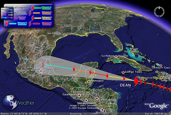
"Fiercely powerful Hurricane Dean strafed Jamaica's southern coast on Sunday, littering the capital of Kingston with fallen trees and windblown roofs after killing six people earlier on its run through the Caribbean. Dean was an "extremely dangerous" Category 4 hurricane, the second-highest on the five-step Saffir-Simpson scale, and could become a potentially catastrophic Category 5 near Mexico's Yucatan Peninsula, the U.S. National Hurricane Center said.

Jamaica's government declared a 48-hour curfew and the power company switched off electricity as the wind began to howl and pounding waves battered the southern coast. Sheets of rain pelted Kingston and streets were blocked by toppled trees and utility poles. Dean ripped off several roofs and a man was missing after falling trees tore into his house. "The dead center of the eye is south of Jamaica by a few miles. But the center is close enough to Jamaica that they are likely getting hurricane-force winds along the southern coast," said Richard Knabb, a storm expert at the hurricane center. Mudslides were reported in several parts of the mountainous country of 3 million people.


Local media reported 17 fishermen and women had been stranded ahead of the storm on the Pedro Cays, a small island chain in the open sea about 50 miles (80 km) south of Kingston, directly in the path of the hurricane. They were told to break into a coast guard building for shelter but officials did not know if they had done that. The government had urged residents to go to shelters. But many people, including those in one low-lying seaport town close to Kingston, refused to flee. "We are going nowhere," Byron Thompson said in the former buccaneer town of Port Royal, settled by pirate Henry Morgan in the 16th century. "In fact, if you come by here later today you will see me drinking rum over in that bar with some friends." Earlier in the day, tempers flared in shops where Jamaicans scrambled to stock up on batteries, flashlights, canned tuna, rice and water. Campaigning for August 27 elections was halted."


Dean May Strengthen into a Category 5 Hurricane on Monday While Impacting Grand Cayman Island...Rough Surf and Rip Current Threat Increases in the Florida Panhandle Waters on Tuesday and Wednesday...Dean to Impact Mexico's Yucatan Peninsula on Tuesday...

Current Storm Position as of Aug 20 - 03:00 UTC Category 4 Hurricane, Maximum winds of 145 mph and a pressure of 924 mb, Latitude: 17.6/Longitude: -78.

Coastal Watches/Warnings and 5-Day Track Forecast Cone [Image of 5-day forecast of predicted track, and coastal areas under a warning or a watch]


More images of Hurricane Dean can be found at Beau's Weather Blog


Hurricane History 1938

The New England Hurricane: New York, Connecticut, Rhode Island, Massachusetts, Vermont, September 1938
With weather radar and satellite technology ll, a hurricane brought the driving rain, battering salt spray and lethal winds of the tropics to landfall on Long Island, N.Y. The powerful storm overcame immense obstacles — cold water, east-moving ocean currents, sea-bound winds — to reach the dense, vulnerable northern cities and seashores, where it left catastrophe in its wake.

The New England Hurricane of 1938 started out as an unremarkable tropical depression just off the west coast of Africa, south of the Cape Verde Islands. It first caught the attention of weather forecasters in the United States as it passed north of Puerto Rico on Sept. 18 and 19 as a powerful Category 5 hurricane. But instead of pummeling directly into Florida, the hurricane skirted the Bahamas and banked north up the East Coast. Without weather radar and satellite technology, forecasters could only wait for news from ships caught in and near the storm. Finally, at 8:30 am on Sept. 21, a ship reported the hurricane just 100 to 150 miles off the coast of Cape Hatteras, N.C., 35 degrees north — an area considered the make-or-break point for New England-bound hurricanes. Usually, it's the break point: In 1938, it had been more than a century since such a powerful hurricane hit New England (in 1815). During normal summertime weather patterns, the east-flowing winds of the jet stream push impending northeast hurricanes out to sea. But on that September day, according to Harvey Thurm, hurricane program manager for the eastern region of the National Oceanic and Atmospheric Administration, reconstructed air maps suggest that the jet stream's flow bent southwards toward the Gulf of Mexico, and then blew northwards up the eastern seaboard. "Once the hurricane got caught up in that it was like a cork in a river's flow," Thurm says.

But even that would not have been enough to propel the storm up the coast. Warm water acts as fuel for hurricanes, and above Cape Hatteras, where the warm ocean currents of the Gulf Stream veer east, the water temperature begins to drop. "It's got to be a very powerful, very fast-moving hurricane to make it through the cold water," Thurm says. And it was: Traveling at 60 to 70 mph (twice as fast as many hurricanes), and aided by high-pressure systems to the east and west that formed a canal of low pressure, the hurricane muscled its way past Cape Hatteras, plowed through the cold water, and barreled into Long Island in just 6 hours.

Residents were caught off guard when, at 3:30 pm on the 21st, a hulking, foaming 16-ft. storm surge crashed ashore, spreading two-story-tall waves from central Long Island to Gloucester, Mass., about 250 miles apart. The surge enveloped shore towns, leaving standing water 6 ft. high and killing 29 in the small community of Westhampton, N.Y., alone. Survivors "grabbed onto telephone poles as boards, planks, and timbers pelted them," writes Everett Allen in A Wind to Shake the World. "The wind was southeast at well over 100 mph and the sand in the air was terrific." The troughs of towering waves left the bay floor dry, and the wind drove ducks backward in flight.

While the storm focused its force on the shore, waves littered the interior of Long Island with debris. The water tossed dozens of boats 300 ft. in from the coast, destroyed hundreds of houses, washed wreckage out to sea or deposited it inland, and scattered cars everywhere. The hurricane's relentless waves punched a hole through the beach at Shinnecock Bay, cutting it in two and creating Shinnecock Inlet, which still exists today. After devastating New York's coast, the hurricane's eye skipped across Long Island Sound and headed straight for Connecticut, Rhode Island and Massachusetts, hitting each with equal fury. Winds blew as high as 120 mph, mercilessly driving the storm surge into the shore. Continued...

In New London, Conn., at the mouth of the Thames River, the storm surge took the Marsala, a colossal 300-ft., five-masted cargo ship, along with its 8- and 10-ton anchors, and slammed it into the town's dockside warehouses, sparking a fire. Firefighters waded through chest-high floodwater to fight it for the next 10 hours. To the east, in Rhode Island, residents peered toward the ocean at what appeared to be a fast-moving fog bank. But when it drove closer, they realized, instead, that they were coming face-to-face with 40-ft. waves pushed by the storm surge. One hundred people were killed as the hurricane came ashore around Westerly and swept 500 homes into the sea.
The surge then worked its way north and west, funneling into Narragansett Bay and overwhelming the state's capital, Providence, at 4:45 pm — just a little over an hour past first landfall. Some Providence citizens retreated to the steps of the city hall as 14 ft. of water topped over vehicles, trolley cars and pedestrians. At the Biltmore, hotel guests hung knotted sheets out of their windows so that others caught in the flood below could grab them. At least 262 people were killed in Rhode Island, though in the 2003 book Sudden Sea: The Great Hurricane of 1938 author R.A. Scotti contends that the state's death toll was closer to 433. According to Scotti, plane crews performed the final tally by air, counting heads bobbing in the water.

The storm surge came ashore as far east as Cape Cod, Mass., where 8 ft. of water covered the resort town of Falmouth. Meanwhile, the eye of the hurricane headed straight up the Connecticut River and dropped up to 17 in. of rain as it pushed north toward Canada. The ground in western New England was already saturated from several days of rain, contributing to flood conditions. The Connecticut River rose 20 ft., burst its banks near the capital of Hartford and spread out 4 miles. Ninety-seven people died in Connecticut.

By 8 pm, not quite 12 hours after the hurricane passed Cape Hatteras, the storm mowed through interior Vermont, toppling tens of thousands of trees, and uprooting whole apple orchards in Burlington. In Montpelier, 50 miles south of the Canadian border, and 240 miles from Long Island Sound, the hurricane lashed houses with the salt spray it had picked up in the Atlantic Ocean. The hurricane crossed into Canada by 9 pm and faded away, leaving $6.2 million dollars in wreckage (or more than $15 billion in 2006 dollars) in its wake. In addition to killing nearly 700 people, the hurricane and the resultant flooding and storm surge injured 3500, left 63,000 homeless, damaged 75,000 buildings, and sunk 3000 boats as it came to shore. Continued...


The Aftermath

After more than a hundred years without a hurricane, the 1938 storm reminded northeasterners that they, too, are vulnerable to tropical-force destruction. And, because a storm must be incredibly fast and strong to reach New England, when a hurricane does come, it comes hard. Despite obstacles such as the jet and Gulf streams, five hurricanes have hit the northeast coast since 1938. The last one was Gloria, in 1985. Though none have connected with New York City, a direct, powerful hit could easily become the most catastrophic hurricane in U.S. history, based on the high population density and the difficulty of evacuating the island of Manhattan through the limited bridges and tunnels.

"It's a low-frequency event," says Thurm, who lives and works in Long Island. "But it would have a tremendously high impact. And it wouldn't take much of an adjustment in the upper air pattern to bring one right over New York Harbor." New Yorkers and East Coasters should know the basic National Weather Service nomenclature that is so familiar along the Gulf Coast. A hurricane "watch" is typically issued between 24 and 36 hours before a hurricane might hit, and means: Pay attention, something may be coming your way. A hurricane "warning" is more serious.

Issued roughly 24 hours before a hurricane might hit, it means: Get out of the way.
It took decades for NOAA and the National Weather Service to create the technology that would allow them to predict the path of hurricanes and warn the vulnerable and unsuspecting — exactly what didn't occur in 1938. Primitive radars came on line in the 1950s, and the more sophisticated Doppler radar wasn't operational across the United States until the 1990s. Today, forecasters also use satellites and computer modeling to predict a hurricane's path and warn the public before it's too late.

To help the weather service make their hurricane predictions, NOAA also operates a small air force of planes that fly into, around and in front of hurricanes. "Besides the hurricane hunters that fly into the eye of the hurricane, there's a NOAA Gulfstream G-IV that flies at high altitude sampling the storm environment ahead of a hurricane," Thurm says. "For example, in the case of a hurricane headed for the northeast, they'd be looking to see if there's a southerly flow [northbound jet stream] present, and if so how strong is it, and which direction is it heading. It's a whole new world compared to 1938."


RS