Showing posts with label Tropical Storm. Show all posts

Wednesday, August 27, 2008

The scoop on tropical storms vs. hurricanes

The scoop on tropical storms vs. hurricanes

By
Scott Sistek

I figured with Tropical Storm Fay in the news wandering around Florida, now might be a good time to chat about hurricanes and tropical storms and answer some frequently asked questions we get in the ol' e-mail bin:

1) What is the difference between a "Tropical Storm" and a "Hurricane"?

It's all about the wind. A hurricane is any tropical based storm that has wind speeds greater than 74 mph. A "tropical storm" is a storm with winds of 39-73 mph. A "tropical depression" is when the Florida Marlins lose to the Atlanta Braves -- or when a storm is tropical in nature, but has winds under 39 mph.

We only name the storms when they get to "tropical storm" strength or higher. Tropical depressions just get plan numbers like "Tropical Depression 3". I guess that's because we only have 21 names and we don't want to run out as they are more common.

2) So, then what's a typhoon?

That is a hurricane, just in a different part of the world. The term "hurricane" is used for storms in the North Atlantic, Northeast Pacific Ocean east of the International Dateline, or the south Pacific Ocean east of 160 degrees East longitude.

A typhoon is a storm in the northwestern Pacific west of the International Dateline -- i.e., storms that strike the northeast Asian coasts like Japan, China and Taiwan.

A cyclone is officially a hurricane/tropical storm that occurs in the Indian Ocean. Although the term has also become colloquially associated with tornadoes in the Midwest, but that is not an official definition. Cyclone Nargis was in the news recently when it hit Myanmar.

3) Fay? Cristobal? Dolly? Who Names These Things?

The World Meteorological Organization is in charge of selecting names for hurricanes. It was developed in the 1950s to make it easier to communicate storms to the public and mariners (instead of "that big storm at 34.423 degrees N and 78.232 degrees West, oops now 78.233").

It used to be just women's names were used, but in 1979, it was decided that men shouldn't miss out on being picked on for having a storm named after them, so now it alternates male/female. (And as of yet, no "Scott" on the list, whew!)

There are six lists that rotate every six years. When a hurricane does massive destruction, (like Katrina) the name is retired and a new name replaces it, (welcome, "Katia"). (See list of retired names here)

In the Atlantic Ocean, storm names are a mix of Anglo/English, Spanish and French names in deference to the languages of the countries that these hurricanes typically strike. A separate list is maintained for the Pacific Ocean, and there are several other lists used for storms in other parts of the world, again using names more common to each region. That link above has the entire lists.

As to how they come up with the names, that is a closely guarded secret. They typically pick names that are easy to understand, but beyond that, the WMO huddles in a corner and then mysteriously comes out with the names. (There's no truth to the long-standing rumor that it's ex- boy/girlfriend names of those on the panel :) )

What Happens When We Run Out Of Names?

You'd think with 21 names available that'd be enough. (We skip "Q", "U", "X", "Y" and "Z" just due to lack of names that start with those, or meteorologists just don't date very many Zekes, Yolandas or Xaviers.) Up until 2005, we'd never gotten past the "T" name. But then 2005 was tropical storm haven, with 27 storms.

But scientists are nothing if not great at planning ahead. The rule was to start using the Greek Alphabet once the next storm formed after "Wilma." So we had Alpha, Beta, Gamma -- all the way up to Zeta, becoming the first Atlantic storm ever to start with a "Z" (and sound like a UW frat at the same time.)

What Steers Hurricanes?

You might be wondering how hurricanes move after watching the meandering track of Tropical Storm Fay, which might be the first tropical system in history that should have been required to have a designated driver. It's made landfall in Florida three separate times, and could possibly make landfall a fourth and *fifth* time along the Gulf Coast.

It's the upper level winds that determine where a hurricane might go, but when you get a situation where the upper level winds are very weak and variable, as they are over the Gulf Coast and Florida right now, storms can drift or meander.

Here's another one with a wacky track: Hurricane Ophelia

There was another one, and I can't find which one it was, where it made landfall into central Florida, then, as if it realized it made a wrong left turn at the light near Vero Beach, actually backed up and out into the Atlantic, and raced north and made landfall again farther north up the seaboard.

4) What does "Category 3" mean?

Hurricanes are rated by top wind speed on the Saffir-Simpson scale. Starting at 75 mph, you go up in category about each 20-25 mph in wind speed. A Category 3, for example, is a storm that has top winds of 111-130 mph. Anything over 155 is a Category 5.

So far, only three "named" Category 5s have ever struck the U.S. -- Hurricane Andrew in 1992, Hurricane Camille in 1969, and the "Labor Day" hurricane that struck the Florida coast in 1935, but that was before storms were given names.

Note that Hurricane Katrina was a Category 5 in the Gulf of Mexico, but weakened to a Category 3 before making landfall at New Orleans. But it was the storm's surge and the levy failures that led to the widespread destruction along the Gulf Coast and New Orleans there, not so much the wind.

Why Don't We Get Hurricanes In The Northwest?

Hurricanes need warm, ocean water to survive, and the water temperatures off the Pacific Coast are generally in the 50-60 degree range -- way too cold for hurricanes to survive. In fact, a hurricane has never struck the Pacific Coast, but a tropical storm once did hit the shores of San Diego.

But We've Had Big Windstorms, Why Aren't They Named?

Washington and Oregon have both had their share of catastrophic windstorms. The storms of December 2006, and 2007, as well as the Inauguration Day Storm of 1993 and the Columbus Day Storm of 1962 have all had wind speeds over hurricane strength.

But those storms were not tropical in nature, so they are not official hurricanes. They are just big storms. We give then calendar or geographic names, but they don't warrant the attention of the World Meteorological Organization -- probably because it would be a nightmare to manage.

And maybe they don't have that many ex's in the group :)

WEATHER NOTE

USFA reports on fire department preparedness for weather emergencies, natural disasters

The United States Fire Administration (USFA) released a new technical report titled Fire Department Preparedness for Extreme Weather Emergencies and Natural Disasters. This report examines the impact of extreme weather and natural disasters on the fire service and the types of service calls most likely to arise as a result of these disasters.

"Firefighters continue to be called upon to respond to many types of incidents, disasters, and situations ? in all kinds of weather, day and night," said U.S. Fire Administrator Greg Cade. "Our country's fire service is an amazing cadre of specially trained individuals whom the public relies on during emergencies--including extreme weather and natural disasters. This requires all firefighters to be prepared to respond in the most challenging conditions."

Fire Department Preparedness for Extreme Weather Emergencies and Natural Disasters also addresses equipment and planning needed in order to be prepared. Safety, mutual aid, shift management, resource identification, logistics, and other related issues are discussed, along with examples from case studies of fire departments that have learned from experience what can happen. The report provides information fire departments can use to enhance their level of preparedness and ensure greater safety the next time disaster strikes.

"September is again the nation's Preparedness Month," continued Cade. "The USFA is pleased to provide this critical information in support of not only this important Department of Homeland Security initiative but also to continue our mission of ensuring the fire service is capable of responding to any and all emergencies, regardless of scope."

The USFA develops reports on selected major incidents throughout the country. The incidents usually involve multiple deaths or a large loss of property, but the primary criterion for deciding to write a report is whether it will result in significant lessons learned. Under this project, USFA also develops special reports addressing a variety of issues that affect the fire service such as homeland security and disaster preparedness, new technologies, training, fireground tactics, and firefighter safety and health.

For additional information regarding this report, or other USFA Technical Reports, CLICK HERE for the report download page.

MARITIME NOTE

Successful Launch for Third INMARSAT-4 Satellite

Successful Launch for Third INMARSAT-4 Satellite

19th August 2008: Inmarsat, the leading provider of global mobile satellite communications services, has confirmed the successful launch and acquisition of the third Inmarsat-4 satellite.

The satellite was launched on a Proton Breeze M rocket from the Baikonur Cosmodrome in Kazakhstan at 11.43pm BST on 18th August (4.43am 19th August, local time). Inmarsat's tracking station in Fucino, Italy was able to track the satellite while it was still coupled to the Breeze M launch vehicle. Launch provider ILS confirmed successful spacecraft separation at 8.46am BST on 19th August.

The satellite is the third in the I-4 constellation, concluding a decade of development and a $1.5 billion investment. The current constellation of two Inmarsat-4 satellites delivers mobile broadband services to 85 per cent of the world's landmass, covering 98 per cent of the world's population. The third I-4 will complete the global coverage for Inmarsat's broadband services.

Andrew Sukawaty, CEO and Chairman of Inmarsat, said: "The Inmarsat-4s are the world's most sophisticated commercial network for mobile voice and data services, and the successful launch of the third I-4 allows us to complete the global coverage for our broadband services. Once the third I-4 is operational, Inmarsat will have the only fully-funded next-generation network for mobile satellite services."

The Proton Breeze M is one of the few launch vehicles capable of lifting the I-4 satellite � the size of a London double-decker bus and weighing six tons � into geostationary transfer orbit. The I-4 F3 satellite will now undergo a period of deployment and several weeks of comprehensive tests and maneuvers before being positioned in geostationary orbit at 98� West.

Inmarsat satellites are currently relied on by the world's shipping, oil exploration, defense and aviation industries to service their communications needs. Inmarsat is also the communications channel of choice for the media when reporting from the world's danger zones and for NGOs, government agencies and the United Nations when coordinating rescue efforts.

RS

Wednesday, January 9, 2008

Black Sea Storms

Back on Tuesday, November 13, 2007 we reported on a severe storm that sunk several Russian ships on the Black Sea ( See Mother and Her Fury!). We recently reported on severe weather grounding the vessel Vanessa, (See Dar be Storms Ablow'in! ) and severe weather effecting Bulgaria and Romania. These at-sea storms have a deadly impact on ships and their crews while most of the incidents go unreported by electronic media outlets both in the United States and worldwide. For example, Cargolaw reported on the Vanessa,

"Bulgarian cargo M/V Vanessa, with 10 crew and a pilot aboard and cargo of scrap metal, sank in the Kertch Strait in severe seas on Jan 3 at 0600LT. There were 11 people on board the ship -- 10 Bulgarian crewmen and a Ukrainian pilot. Two ships proceeded to M/V Vanessa after its SOS-call but were unable to help due to the storm. Rescuers found only one survivor and the bodies of three crew. The bodies were taken aboard a rescue speedboat. Before the sinking the bulwark was torn from the ship. From our Sr. Correspondent Tim Schwabedissen and our Moscow Correspondent Mike Voitenko (Thurs. Jan 3 2008)."

Anyone remember seeing this report on any of the US major news outs? At-Sea Storm reports are just as critical if not even more critical than shore-side reports, since severe weather happens at sea more often than on shore. I include subsea storms or weather pattens exclusive to the oceans. Of course chasing these weather systems is not that easy either.

Chasing maritime weather systems is very different from chasing shore-side storms. Normally a seaman is not chasing, he is normally being chased or caught in the storm with limited escape possibilities. Meaning he is forced to ride out the storm. I can assure you that riding out one of these storms is not pleasant and scary. Like the old saying, "there is no atheists in a fox hole", well there are no atheists at sea either... As its been said, "Ship Happens!"

Thanks to my good friend and shipmate Captain John Konrad of gCaptain.com, These dramatic pictures are from Novembers storm.

storm in Ukraine 2


storm in Ukraine 2


storm in Ukraine 4

storm in Ukraine 5

storm in Ukraine 6

storm in Ukraine 7

storm in Ukraine 8


storm in Ukraine 6

storm in Ukraine 7


MARITIME NOTES

Cargolaw has a posting asking for assistance in solving this mystery. Dr. Beach Asks: What Vessel Lost This?

This little note from our British friends...

Gale-force winds of more than 75mph buffeted parts of Scotland and Northern Ireland today, causing flooding and danger on the roads. Ferry services between Northern Ireland and Scotland were suspended last night because of the weather conditions, which reached 78mph in the Isle of Islay off the west coast of Scotland. The Forth Road Bridge remained closed to all vehicles except cars, and Fife Constabulary said roads in the area suffered from minor flooding. The high winds would continue today, shifting further north as the day continues, leading to a bright day with blustery showers, forecaster said. The Met Office issued a severe weather warning of winds up to 80mph with the the prospect of structural damage. Tony Conlan, a forecaster with MeteoGroup, the Press Association's weather division, said the highest gust measured 78mph in the Isle of Islay. He said even stronger gusts were expected today across Northern Ireland and central Scotland. He said that by the evening most places will have seen the last of the bad weather, for now. Stena Line cancelled both fast ferry and conventional ferry services between Belfast and Stranraer because of the severe weather.

The firm warned of further possible disruptions today. Police warned of a road closure in Lisburn, County Antrim, Northern Ireland after power cables were brought down. The Foyle Bridge in Londonderry, Northern Ireland was closed to all traffic. A spokeswoman for Fife Police said: "Numerous trees have been blown down blocking the roads and we have had some minor flooding across the region. "But it has not been a disaster, it has just been a bad winter night due to high winds and sweeping rain." Rough sea conditions in the English Channel were causing delays this morning to some ferry services, the Port of Dover said. All sailings from the Eastern Docks with P&O Ferries were running about 90 minutes late. Norfolkline services to Dunkerque were also experiencing some disruption to their timetables, a port spokeswoman said.


RS

Monday, September 17, 2007

Remote Operated Vehicles II -Weather Story and Maritime Note

Remote Operated Vehicles (ROVs) have had a great impact on the maritime community. Lets take a look a another type of ROV.

Jason/Medea(ROV)

Jason/Medea is a remotely operated vehicle (ROV) system designed by the Woods Hole oceanographic Institution’s Deep Submergence Laboratory for scientific investigation of the deep ocean and seafloor. It is a two-body ROV system, with Medea serving in a tether management role that decouples Jason from surface motion.

Together they offer wide area survey capabilities with Jason as a precision multi-sensory imaging and sampling platform. Both Medea and Jason are designed to operate to a maximum depth of 6,500 meters (21,385 feet), are transportable, and can be operated from a variety of vessels.

Medea, shown on deck, serves as a buffer between Jason and the ship.

Medea, shown on deck, serves as a buffer between Jason and the ship. Image courtesy of Woods Hole Oceanographic Institution.


Jason is connected to Medea by a neutrally buoyant tether that is 0.84" in diameter and approximately 35 meters long. Like the tow cable, it also uses three copper conductors and three single-mode optical fibers, but uses Spectra fibers to provide strength while reducing size and weight. The tether has a breaking strength of 41,000 lb. Medea weighs 1200 pounds in air and is maneuvered by controlling the surface ship’s position within a dynamic positioning reference frame.

Movements of the support ship maneuver Medea utilizing dynamic positioning. Jason is propelled by six DC brushless electric thrusters that provide about 600 pounds thrust in the vertical, longitudinal and lateral directions. The vehicle has excellent passive stability in pitch and roll. Jason is designed for detailed survey and sampling tasks that require a high degree of maneuverability. It weighs about 8,000 pounds in air but is neutrally buoyant at depth. Jason’s closed loop controlled dynamic positioning abilities make it a very maneuverable and stable platform.

Both Medea and Jason have been designed to be superior real time optical imaging platforms with high quality cameras and lighting. The vehicles work together to provide lighting for each other in a fashion not commonly available in other submersible systems. Medea is configured with a silicon intensified target (SIT) black & white camera for terrain identification and visual location of Jason when both are operating.

Jason's sample tray

Jason's sample tray. Click image for larger view and image credit.


Jason's sample tray can be configured in a variety of arrangements to accomplish the Scientist's objectives. Typically, Jason will carry water samplers, push cores to collect seafloor cores (mud!), a "slurp" pump to collect critters, a temperature probe to record the ultra hot temps of water coming out of the hydrothermal vents. Many researchers wish to collect rocks which Jason collects with its manipulators. Up to 310 lbs of samples can be stored on Jason's tray and brought back to the surface.

Once Jason is in the water, it takes 3 people to operate it - a Pilot who "flies" the ROV, an Engineer who monitors all the systems (electrical, mechanical, hydraulic, etc) and operates the winch which pays out / hauls in the fiber optic cable which is attached to Medea and a Navigator who positions the research vessel so that Medea and Jason can operate in the desired area. Because the vehicles are capable of operating 24 hours per day, 3 shifts of people are required to run it. Therefore, 9 people go to sea with Jason - plus a 10th person who is responsible for organizing all the data which is collected! The first Jason ROV began its career in 1988 and retired in 2001. During that time, Jason made 253 dives with 4683 hours on the bottom! The longest dive the first Jason made lasted 117 hours. The new ROV Jason has been in operation since 2002. So far, 183 dives have been made with 3249 hours on the bottom.

The Web team gratefully acknowledges this contribution by Woods Hole Oceanographic Institution, Woods Hole, MA.

Weather Story

The Latest on Ingrid...

Click for Eastern Pacific

000
ABNT20 KNHC 170230
TWOAT
TROPICAL WEATHER OUTLOOK
NWS TPC/NATIONAL HURRICANE CENTER MIAMI FL
1030 PM EDT SUN SEP 16 2007

FOR THE NORTH ATLANTIC...CARIBBEAN SEA AND THE GULF OF MEXICO...

THE NATIONAL HURRICANE CENTER IS ISSUING ADVISORIES ON TROPICAL
DEPRESSION INGRID...CENTERED ABOUT 160 MILES EAST OF THE LEEWARD
ISLANDS.

1. SHOWER ACTIVITY HAS DECREASED THIS EVENING OVER THE CENTRAL
CARIBBEAN SEA IN ASSOCIATION WITH A TROPICAL WAVE AND AN UPPER-LEVEL
TROUGH. UPPER-LEVEL WINDS ARE CURRENTLY UNFAVORABLE FOR
DEVELOPMENT OF THIS SYSTEM...BUT THEY COULD BECOME A LITTLE MORE
FAVORABLE FOR SLOW DEVELOPMENT OVER THE WESTERN CARIBBEAN IN A
COUPLE OF DAYS AS THE SYSTEM MOVES WESTWARD AT 10 TO 15 MPH.

2. A TROPICAL WAVE LOCATED ABOUT HALFWAY BETWEEN AFRICA AND THE LESSER
ANTILLES IS PRODUCING A LARGE BUT DISORGANIZED AREA OF CLOUDINESS
AND THUNDERSTORMS. DEVELOPMENT OF THIS SYSTEM...IF ANY...IS
EXPECTED TO BE SLOW TO OCCUR IT MOVES WESTWARD AT 10 TO 15 MPH.

ELSEWHERE...TROPICAL CYCLONE FORMATION IS NOT EXPECTED DURING THE
NEXT 48 HOURS.

$

FORECASTER KNABB

Update on Typhoon NARI

Summary

At the last observation, on 2007/09/16 12:00 UTC, tropical cyclone NARI is a Tropical Storm with maximum sustained wind speeds of 30 m/s (111 km/h, 60 knots). Within 100km of its eye there are 5.6 million people. Within 200km there are 22.3 million people.

The storm is affecting the provinces Cholla-bukto in South Korea (less than 1000 people), Cholla-namdo in South Korea (less than 1000 people), Ch'ungch'ong-namdo in South Korea (2 million people), Kyongsang-bukto in South Korea (2.8 million people), Kyongsang-namdo in South Korea (3.6 million people), Kwangju-jikhalsi in South Korea (1.1 million people). The closest 6 cities are Suncheon, Samcheongpo, Yeosu, Jeonju, Gimje, Jinju.

New Typhoon - Typhoon 13W (Wipha)

https://metocph.nmci.navy.mil/jtwc/satshots/13W_162330sams.jpg


Update on the F/V Papa George

We have spoken to the United States Coast Guard Marine Causality Investigations Division Portland. Unfortunately the make and model number of the EPIRB in question was lost with the vessel. Though the EPIRB was inspected and certified for some reason when the vessel went down the EPIRB did not release. The f/v Papa George sank in deep water and there is no contemplation of salvage currently.

We are continuing to seek information about the EPIRB through other sources.

Maritime Note:

New Flame to be split in two as part of the salvage operation

The New Flame off the southern most point of Gibraltar - Photo EFE
The boat remains half sunken off Europa Point after colliding with a tanker on August 12 The Gibraltar First Minister, Peter Caruana, announced on Friday that the 'New Flame' cargo ship, which suffered a collision near the rock on August 12, will be broken into two sections once all the fuel it contains has been removed.

After the separating he said that stern would remain afloat, and could be towed to a safer location in the bay. Then the 27,000 tons of scrap metal it contains would be removed. The bow of the boat is at a depth of 23 metres underwater and will be salvaged in sections.

He said work to salvage the vessel would start in three weeks and take four to six months to complete, depending on the weather, and that there was no risk of pollution in this second phase of the operation.

So far the Greek salvage company, Tsavliris, have removed 780 tons of fuel from the ship’s tanks.

Caruana thanked the Spanish Government and the European Agency for their offers of help, but noted Gibraltar had taken less time than Spain to remove the fuel from the vessel, when compared to the 'Sierra Nava' case.


Have a great week!

RS

Thursday, September 13, 2007

Remote Operated Vehicles

Let's take a look at some technology that is critical to both the oceanography and salvage fields. They are known as Remote Operated Vehicles (ROVs).

Remotely operated underwater vehicles (ROVs) are unoccupied, highly maneuverable underwater robots operated by a person aboard a surface vessel.

They are linked to the ship by a group of cables that carry electrical signals back and forth between the operator and the vehicle. Most are equipped with at least a video camera and lights. Additional equipment is commonly added to expand the vehicle’s capabilities. These may include a still camera, a manipulator or cutting arm, water samplers, and instruments that measure water clarity, light penetration, and temperature. First developed for industrial purposes, such as internal and external inspections of pipelines and the structural testing of offshore platforms, ROVs are now used for many applications, many of them scientific. They have proven extremely valuable in ocean exploration, and are also used for educational programs at aquaria and to link to scientific expeditions live via the internet.

Deployment and Maneuverability

ROVs range in size from that of a bread box to a small truck. Deployment and recovery operations range from simply dropping the ROV over the side of a small boat to complex deck operations involving large winches for lifting and A-frames to swing the ROV back onto the deck. Some even have “garages” that are lowered to the bottom. The cabled ROV then leaves the garage to explore, returning when the mission is completed. In most cases, however, ROV operations are simpler and safer to conduct than any type of occupied-submersible or diving operation.

<span class=

Lights and video cameras equip ROVs, enabling the operator to record imagery below the ocean surface. The S2 Phantom ROV, shown here, can move horizontally, vertically and laterally. Click image for larger view.


The disadvantages of using an ROV include the fact that the human presence is lost, making visual surveys and evaluations more difficult, and the lack of freedom from the surface due to the ROV’s cabled connection to the ship. The S2 Phantom ROV highlighted here has been rated to an operating depth of 2,400 ft. The vehicle has four thrusters that each provide one-half horsepower of thrust for horizontal, lateral, or vertical movement. Two of the thrusters are mounted horizontally. They allow the vehicle to move forward and backward, and to turn left and right. The other two thrusters are mounted at an angle, slanted in opposite directions. They provide vertical thrust (when both spin in the same direction) and lateral thrust (when they spin in opposing directions, one pushing water up, the other pushing it down).

An ROV operator controls the vehicle from a system on board the ship. Using a joystick, a camera control, and a video monitor, the operator moves the vehicle and the camera to desired locations; the operator’s eyes essentially “become” the camera lens. The vehicle’s depth, heading, and geographic position (latitude and longitude) are also recorded.

Multiple Uses

ROVs are often kept aboard vessels mounting submersible operations for several reasons; the first is safety. In the event that a submersible becomes entangled or otherwise incapacitated, an ROV can investigate the scene to help the operators decide how to respond. If appropriate, cutter blades can be attached to the manipulator arm and used to free the sub. If a sub loses power and cannot surface, the ROV’s manipulator arm can grab onto the sub. The deck crew can then bring the sub to the surface.

ROVs also support exploration and science objectives. When the submersible cannot be used because of weather or maintenance problems, the ROV often can take its place. It can also be used to investigate questionable dive sites before a sub is deployed, limiting risk to the expensive subs and their pilots.

Lets take a look at a salavge application.

The Wreck of the Bow Mariner

Information about the tragic explosion and sinking of the Bow Mariner

Feb. 28, 2004

click on photos to see the full size image

photos courtesy of NOAA

click to enlarge
Bow Mariner's sister ship-Bow Petros
photo courtesy of Dennis Shum

On Saturday, February 28, 2004 the Bow Mariner, a 570 foot tanker was southbound off the coast of Virginia when it caught fire, exploded and sank. The tanker was carrying 3.5 million gallons of ethanol, 48,000 gallons of stored diesel fuel and 193,000 gallons of fuel oil. The vessel was roughly 50 miles east of Chincoteague, Virginia in about 240 feet of water when it sank. Water temperature was around 44 degrees at the time.

A scallop boat Captain described the disaster:

"I was 30 miles north of the Bow Mariner when she blew. I heard the MayDay(s) and about 20 seconds later all the other trawler skippers say "Look at that! The flames are several hundred feet." then the explosion and the flames were several thousand feet." Another scalloper described it this way..."The sun was setting in the west and from the flames on the Bow Mariner it looked like another sun was rising in the east."

Six survivors and 3 bodies were initially recovered from the water. The Coast Guard suspended the search for the 18 missing crewmembers from the Bow Mariner at 1 p.m. March 1, 2004. The search had involved more than 80 Coast Guardsmen, including crews from Station Chincoteague, Va., Air Station Atlantic City, N.J., and Elizabeth City, N.C., the 87-foot patrol boats Shearwater and Albacore from Hampton Roads, Va., and six command centers. Crews conducted 30 separate search patterns expending more than 3,500 man hours and covering an area of approximately 70 square miles.

Reports from the various government agencies as well as local witnesses described the ethanol to be dissipated and the oil slick to be about 9 miles in length off the coast within days. Favorable weather helped disburse the oil and carry it offshore. The Marine Spill Response Corporation (MSRC) oil recovery vessel Virginia Responder was dispatched on the scene and recovered approximately 25,000 gallons of an oily water mix about 18 miles from where the vessel sank.

The USCG cooperated with NOAA on the disaster and the NOAA Ship Rude was brought in to survey the wreck with side scan sonar technology. In addition SMIT Salvage was contracted to explore the wreck further and possibly extract chemicals from the vessel.


The ROV (ROLS)
FRAMO Remote Offloading System

Salvage work began in the case of the tanker BOW MARINER, on Feb.28 after experiencing several explosions and fire. Six crewmen survived, 3 bodies have been recovered and 18 are missing.

The salvage team deployed a Remotely Operated Vehicle (ROV) and specialized divers to locate the missing crewmembers of this tragic accident. The salvor's second task was to remove the bunker oil from the tanker that lies in the Atlantic Ocean at a depth of approximately 264 feet.

Heavy weather has hampered ROV operations to locate the missing seamen as well as survey operations to determine whether recoverable quantities of its cargo of ethanol or bunker fuel remain in the vessel. The salvage team used a unique pollution recovery system, the FRAMO Remote offloading System (ROLS) that has been designed to remove oil and chemicals from vessels lying on the seabed in very deep water without the assistance of divers.

This ROV reverse screws itself in the side of the ship board tanks and drills a 3/8" dia hole, inserts its impeller into the ships tanks and then begins to pump the bunkers to a waiting ship or barge on the surface.

Next we will take a look at other specific ROVs and there missions.

Maritime Notes:

Other marine casualities due to storms. from Cargolaw

90-m 3,183-gt Cyrpus-flagged cargo M/V Storoe (IMO 9321530) lost several hundred logs in the North Sea off Juist in rough seas on Sept. 9. Warnings for navigational hazards have been issued. From our Sr. Correspondent Tim Schwabedissen (Wed. Sept. 12 2007)

Spanish F/V Nueva Pepita Aurora, with 16 men aboard, sank amidst strong winds in the waters off the town of Tarifa, southern coast of Spain, on Sept. 5. Three people reported dead and five others missing. (Thurs. Sept. 6 2007).

Weather Story: UPDATE 13.08.2007


HURRICANE HUMBERTO woke up the Southern Texas Coast!

Sept. 13 (Bloomberg) -- Humberto, the third hurricane of the Atlantic season, slammed into eastern Texas early today with winds of 85 miles (135 kilometers) an hour.

Humberto hit the Texas coast east of High Island at about 2 a.m. local time, the U.S. National Hurricane Center said on its Web site. At 7 a.m., Humberto was about 25 miles west-northwest of Lake Charles, Louisiana, on the Texas-Louisiana state line, heading northeast at 12 mph. Sustained winds weakened to 80 mph.

The system grew to a hurricane less than 24 hours after developing into a tropical depression. It is expected to weaken to a tropical storm over land.

Forecasters are also monitoring a system about 930 miles east of the Lesser Antilles with sustained winds of about 35 mph. The depression in the Atlantic may develop into a tropical storm today, the center said in a separate advisory.

Humberto prompted the center to issue a hurricane warning from east of High Island to Cameron, Louisiana. The area includes three major oil refineries around Port Arthur and Beaumont in Texas. Texas Governor Rick Perry put National Guard forces, helicopters and vehicles on standby for search-and-rescue operations as Humberto intensified from a depression to a storm. A state of emergency was declared yesterday in Louisiana.

``Some areas of our state remain saturated by summer floods, and many communities in this storm's projected path are at high risk of dangerous flash flooding,'' Perry said on his Web site. ``We will work with local officials to provide the state resources necessary to ensure the safety of all Texas residents as this storm moves over.''

Plants in Area

The warning area for Humberto encompasses a Total SA plant producing 240,000 barrels of oil a day, Valero Energy Corp.'s 325,000 barrel-a-day facility and the 285,000 barrel-a-day Motiva Enterprises LLC plant. Motiva is a refining joint venture between Royal Dutch Shell Plc and Saudi Aramco.

Humberto's sustained winds of 85 mph made the system a Category 1 hurricane, the weakest on the five-step Saffir-Simpson scale. Hurricane-force winds extended 15 miles from the eye of the storm, and tropical storm-force winds of at least 39 mph reached out 60 miles.

The system was forecast to dump as much as 15 inches (38 centimeters) of rain on a track from southwestern to northeastern Louisiana, southeastern Arkansas and into central and northern Mississippi.

``Isolated tornadoes are possible in southeastern Texas and southwestern Louisiana through this afternoon,'' the hurricane center said.

To contact the reporter on this story: Alex Morales in London at amorales2@bloomberg.net .

Last Updated: September 13, 2007 08:22 EDT

RS


Wednesday, August 22, 2007

Dean Slams Mexico

Deans Curerent Position:

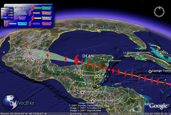
Dean's, current storm position as of Aug 22 - 00:00 UTC. Dean is now a Category 1 Hurricane and may re-strengthen with maximum winds currently of 80 mph and a pressure of 970 mb, tracking Latitude: 19.7 Longitude: -92.2.

Weather Bouy - 42055 just north of Dean reports as of Aug 22 - 00:50 UTC. Temperature: 85.3°F. Wind: NNE at 36 mph gusting to 45. Pressure: 1005.2 mb. Wave Height: 8 ft . This storm still has some power remaining in it. Matter of fact Weather Bouy 42056 just of the coast of Cozumel reports as of Aug 22 - 00:50 UTC. Temperature: 83.8°F. Dewpoint: 77.4°F. Wind: ESE at 22 mph gusting to 27, Pressure: 1011.6 mb, Wave Height: 8 ft. Still 8ft SWHs!

According to Hurricaneville "
The storm became a hurricane as of the 5:00 AM EDT Advisory on Thursday morning. With its latest intensification, Dean became the tenth most powerful storm ever in the Atlantic ahead of Hurricane Janet (1955) and Hurricane Isabel (2003), and right behind Hurricane Ivan (2004). It is also the third strongest hurricane to make landfall in North America behind Hurricane Gilbert and the Labor Day Hurricane of 1935. The forecast track has the storm continuing across the Yucatan over the next days, and possibly emerging into the Bay of Campeche region of the Gulf of Mexico later on Tuesday and going into Wednesday as a Category Two Hurricane with 100 mph winds. Forecasted rainfall amounts for the affected areas are expected to range at least between 5 to 10 inches with some locales getting up to 20 inches over Southern and Central Mexico as well as Guatemala. On top of that, storm surge levels could go as high as 6 to 8 feet to the north of the potential landfall point within the Hurricane Warning area."

Beau's Weather Blog has a
play by play of some of the more dramatic images of Hurricane Dean. Its well worth the time to take a look.

According to FEMA's National Situation Report on Dean states;

Tropical Weather Outlook

Atlantic/Caribbean/Gulf of Mexico:

Category five hurricane Dean makes landfall on the east coast of the Yucatan Peninsula of Mexico.

At 5:00 am EDT, August 21, 2007 the center of Hurricane Dean was located about 35 miles east-northeast of Chetumal, Mexico and about 195 miles east-southeast of Campeche, Mexico. Dean is moving toward the west-northwest near 20 mph and a west-northwestward to westward motion is expected today and tonight when the center will cross the Yucatan Peninsula and likely reach the southern Bay of Campeche.

Maximum sustained winds are near 165 mph, with higher gusts. Dean is a category five hurricane on the Saffir-Simpson Scale. Although some weakening is forecast as Dean crosses the Yucatan peninsula, Dean is expected to maintain hurricane strength throughout the next 24 hours.

Hurricane force winds extend outward up to 60 miles from the center and tropical storm force winds extend outward up to 175 miles.

The hurricane hunter plane reported a minimum central pressure of 906 mb (26.75 inches) just before landfall.

Storm surge flooding of 12 to 18 feet above normal tide levels along with large and dangerous battering waves is possible near and to the north of where Dean made landfall along the east coast of the Yucatan Peninsula.

Dean is expected to produce storm total rainfall of 5 to 10 inches over the Isthmus of Tehuantepec and Yucatan Peninsula of Mexico, Belize, Guatemala, and northern Honduras with maximum amounts up to 20 inches.


RS

Monday, August 13, 2007

50 drowned, 100 missing in Sierra Leone as boat capsizes

Aug 3, 2007 FREETOWN, Sierra Leone (Reuters) -- Around 50 people were feared drowned and more than 100 were missing after their boat capsized in heavy rain at the mouth of a river in Sierra Leone, police said on Friday.

A spokesman for a local boat owners' association said seven bodies had so far been recovered from the sea at the estuary of the Great Scarcies River, near Sierra Leone's northern border.

Police in the northern Kambia district estimated around 50 people had died based on accounts from the only two survivors found so far.

The boat, which was en route from the coastal capital Freetown to the riverside town of Rokupr, was believed to be carrying around 200 passengers when it ran into the choppy river waters, swollen by a week of torrential rains.

"Members of the Sierra Leone navy, backed by some members of the boat association, left in the early hours for the disaster scene to join local fishermen who have been searching since the tragedy took place," said the spokesman for the boat owners' association, Michael Asuman.

Authorities say that the heavy rains have washed away scores of homes in the hilly Freetown area over the last week, leaving more than 500 people on the streets.

Boating accidents are common during Sierr Leonea Leone's treacherous rainy season. Some 25 people drowned in July last year when a wave overturned their boat at the mouth of the Great Scarcies river.

Many of the vessels plying trade and passenger routes on inland waterways and off West Africa's coast are poorly maintained, with accurate passenger manifests a rarity.

Copyright 2007 Reuters. All rights reserved.This material may not be published, broadcast, rewritten, or redistributed.

Martiime Notes:

This from my shipmate at gCaptain.com
Tanker Grounded off Coney Island, NY

After experiencing a steering problem the tanker “White Sea” ran aground off of Coney Island New York. The Gotahamist tells us: Continue reading at gCaptain.com .

Casualties from Cargolaw.com:

Cari-carrier M/V Nobleza, Monrovia-flagged, was caught by strong wind and pushed against pilings in the Kiel Canal with its port side while passing from Brunsbuettel to Kiel-Holtenau on Aug. 5. The vessel lated resumed its voyage with minor dents. From our Sr. Correspondent Tim Schwabedissen (Thurs. Aug. 9 2007)

F/V Zhu Wan 4209 sank in a tropical storm in the waters of the Xisha Islands in the South China Sea on Aug 3. All five abaord were rescued by 35,500-ton German container M/V Northern Faith. From our Sr. Correspondent Tim Schwabedissen (Thurs. Aug. 9 2007).

Weather Story:

CHINA:Thousands of China homes flooded. More than 3,600 homes in southern China have been destroyed by floods resulting from a now fading tropical storm, Chinese state media has reported. The floods in Guangdong province have affected about 1.2 million people and caused an estimated 1.3bn yuan ($171m) of damage, Xinhua news agency said. The rain was caused by Tropical Storm Pabuk, which hit Hong Kong on Friday, disrupting transport and business.

The latest on Hurricane Flossie:

HONOLULU, Hawaii (AP)
-- Hurricane Flossie strengthened to a Category 4 storm Saturday as it spun more than 1,000 miles south of Hawaii.
art.flossie.satellite.noaa.jpg

Satellite image taken at 10:30 a.m. ET shows Flossie's position relative to Hawaii.

At 11 a.m. EDT, Flossie had intensified with maximum sustained winds near 132 mph, and was about 1,100 miles southeast of Hilo, Hawaii. Flossie was upgraded to Category 3 from a Category 1 overnight.

The storm was expected to weaken later in the day as it passed over cooler waters. It was traveling west at about 12 mph.

Jeff Powell, lead forecaster at the National Weather Service in Honolulu, said Flossie hadn't changed its course and was expected to pass the Hawaiian Islands early Wednesday with rough surf. A "ramp up" of surf on the Big Island was expected late Monday.

The island's southeastern shores could see waves of 8 to 12 feet, forecasters said, with the surf rising during the day Monday and peaking Tuesday. The island's South Point is the southernmost area of the United States.

State civil defense officials urged residents to be prepared because of the unpredictable nature of hurricanes. A one or two degree direction change, they say, could make a big difference.

"If this thing fizzles out, so what? Everybody should still be prepared," said Dave Curtis, spokesman for the state Civil Defense Agency.

Flossie formed as a tropical storm Wednesday about halfway between Mexico's southern Pacific coast and Hawaii. Its winds surpassed 74 mph, making it a hurricane, on Friday.

The last time a hurricane hit Hawaii was in 1992, when Iniki ravaged Kauai, killing six people and causing $2.5 billion in damage.

Hurricane season runs from June 1 to Nov. 30. In May, forecasters predicted that Hawaii and the rest of the central Pacific face a slightly below-average hurricane season, with just two or three tropical cyclones expected because of lower sea surface temperatures.The islands get an average of 4.5 tropical cyclones a year and one hurricane about every 15 years. Last year, the central Pacific had five tropical cyclones after the National Oceanic and Atmospheric Administration predicted two to three.

On July 21, a tropical depression moved past the Big Island, bringing a few inches of rain to the parched island but no major problems. Cosme, the year's first Pacific tropical cyclone, reached hurricane status for a day before it weakened.

Finally, how about a little rough seas off of the coast of Japan?


RS