Showing posts with label salvage. Show all posts

Friday, October 3, 2008

Scientist Uncovers Miscalculation In Geological Undersea Record

Scientist Uncovers Miscalculation In Geological Undersea Record

ScienceDaily (Sep. 13, 2008)

The precise timing of the origin of life on Earth and the changes in life during the past 4.5 billion years has been a subject of great controversy for the past century.

The principal indicator of the amount of organic carbon produced by biological activity traditionally used is the ratio of the less abundant isotope of carbon, 13C, to the more abundant isotope, 12C. As plants preferentially incorporate 12C, during periods of high production of organic material the 13C/12C ratio of carbonate material becomes elevated. Using this principle, the history of organic material has been interpreted by geologists using the 13C/12C ratio of carbonates and organics, wherever these materials can be sampled and dated.

While this idea appears to be sound over the last 150 million years or so, prior to this time there are no open oceanic sediment records which record the 13C/12C ratio, and therefore, geologists are forced to use materials associated with carbonate platforms or epicontinental seas.

In order to test whether platform-associated sediments are related to the global carbon cycle, a paper by University of Miami Professor Dr. Peter K. Swart appears in the Proceedings of the National Academy of Sciences. This paper examines changes over the past 10 million years at sites off the Bahamas (Atlantic Ocean), the Maldives (Indian Ocean), and Great Barrier Reef (Pacific Ocean). The variations in the 13C/12C ratio are synchronous at all of the sites studied, but are unrelated to the global change in the 13C/12C ratio.

It appears that records related to carbonate platforms which are often used throughout the early history of the Earth are not good recorders of the 13C/12C ratio in the open oceans. Hence, the work presented suggests that assumptions made previously about changes in the 13C/12C ratios of carbonate sediments in the geological record are incorrect.

"This study is a major step in terms of rethinking how geologists interpret variations in the 13C/12C ratio throughout Earth's history. If the approach does not work over the past 10 million years, then why would it work during older time periods?" said Swart. "As a consequence of our findings, changes in 13C/12C records need to be reevaluated, conclusions regarding changes in the reservoirs of carbon will have to be reassessed, and some of the widely-held ideas regarding the elevation of CO2 during specific periods of the Earth's geological history will have to be adjusted."

The study is funded by the National Science Foundation and the Comparative Sedimentology Laboratory at the University of Miami.

WEATHER NOTE

Climate: New spin on ocean's role

New studies of the Southern Ocean are revealing previously unknown features of giant spinning eddies that have a profound influence on marine life and on the world's climate.

These massive swirling structures � the largest are known as gyres - can be thousands of kilometres across and can extend down as deep as 500 metres or more, a research team led by a UNSW mathematician, Dr Gary Froyland, has shown in the latest study published in Physical Review Letters.

"The water in the gyres does not mix well with the rest of the ocean, so for long periods these gyres can trap pollutants, nutrients, drifting plants and animals, and become physical barriers that divert even major ocean currents," Dr Froyland says.

"In effect, they provide a kind of skeleton for global ocean flows. We're only just beginning to get a grip on understanding their size, scale and functions, but we are sure that they have a major effect on marine biology and on the way that heat and carbon are distributed around the planet by the oceans."

One of the best known large-scale gyres in the world's oceans is that associated with the Gulf Stream in the North Atlantic, notes fellow researcher Professor Matthew England, co-director of the UNSW Climate Change Research Centre.

MARITIME NOTE

Donjon responds to Ike

Hillside, N.J. headquartered Donjon Marine Co., Inc. has been playing its part in cleaning up after Hurricane Ike.

Donjon, whose services include marine salvage, heavy lift, dredging and related emergency response, was contracted by the U.S. Army Corps of Engineers through the company's salvage and related services contract with the U.S. Navy, Supervisor of Salvage of Diving, to remove and dispose of debris after Ike's trek through Texas.

DonjonÕs heavy-lift capability is put to the test in cleanup efforts in the wake of Hurricane Ike

To date, this debris has included vessels, containers and upland material, such as sections of houses and local storefronts, which accumulated in the Gulf Intracoastal Waterway just outside Galveston, Texas.

Donjon subcontracted this work to various area-based marine service providers for equipment and labor, while Donjon provided onsite project management, logistical and financial support.

Great Lakes – dry cargo residue discharge

The US Coast Guard issued a press release stating that, next Monday, it will formally propose regulations that will, if adopted, require operators of lake carriers to keep records of loading, unloading, and discharges of dry cargo residue. It will also encourage lake carriers to use control measures to reduce the amount of dry cargo residue entering waters of the Great Lakes. Discharges into certain protected and sensitive waters will be prohibited. Comments on the proposal should be submitted by January 15, 2009. (9/25/08).

Australia – report on ship-fishing vessel collision

The Australian Transport Safety Bureau (ATSB) issued the report of its investigation of a collision between a liquefied petroleum gas (LPG) carrier and a fishing vessel on 30 November 2007 off Queensland. Neither vessel was maintaining a proper lookout and the LPG carrier failed to report the collision and made no attempt to contact the damaged fishing vessel. (9/25/08).


Messing About In Ships Podcast


STAY SAFE!
RS

Thursday, October 2, 2008

Research team proposes new link to tropical African climate

Research team proposes new link to tropical African climate

The Lake Tanganyika area, in southeast Africa, is home to nearly 130 million people living in four countries that bound the lake, the second deepest on Earth.

Scientists have known that the region experiences dramatic wet and dry spells, and that rainfall profoundly affects the area's people, who depend on it for agriculture, drinking water and hydroelectric power.

Scientists thought they knew what caused those rains: a season-following belt of clouds along the equator known as the Intertropical Convergence Zone (ITCZ). Specifically, they believed the ITCZ and rainfall and temperature patterns in the Lake Tanganyika area marched more or less in lockstep. When the ITCZ moved north of the equator during the northern summer, the heat (and moisture) would follow, depriving southeast Africa of moisture and rainfall. When the ITCZ moved south of the equator during the northern winter, the moisture followed, and southeast Africa got rain.

Now a Brown-led research team has discovered the ITCZ may not be the key to southeast Africa's climate after all. Examining data from core sediments taken from Lake Tanganyika covering the last 60,000 years, the researchers report in this week's Science Express that the region's climate instead appears to be linked with ocean and atmospheric patterns in the Northern Hemisphere. The finding underscores the interconnectedness of the Earth's climate - how weather in one part of the planet can affect local conditions half a world away.

The discovery also could help scientists understand how tropical Africa will respond to global warming, said Jessica Tierney, a graduate student in Brown's Geological Sciences Department and the paper's lead author.

"It just implies the sensitivity of rainfall in eastern Africa is really high," Tierney said. "It doesn't really take much to tip it."

The researchers, including James Russell and Yongsong Huang of Brown's Department of Geological Sciences faculty and scientists at the University of Arizona and the Royal Netherlands Institute for Sea Research, identified several time periods in which rainfall and temperature in southeast Africa did not correspond with the ITCZ's location. One such period was the early Holocene, extending roughly from 11,000 years ago to 6,000 years ago, in which the ITCZ's location north of the equator would have meant that tropical Africa would have been relatively dry. Instead, the team's core samples showed the region had been wet.

Two other notable periods - about 34,000 years ago and about 58,000 years ago - showed similar discrepancies, the scientists reported.

In addition, the team found climatic changes that occurred during stadials (cold snaps that occur during glacial periods), such as during the Younger Dryas, suddenly swung rainfall patterns in southeast Africa. Some of those swings occurred in less than 300 years, the team reported.

"That's really fast," Tierney noted, adding it shows precipitation in the region is "jumpy" and could react abruptly to changes wrought by global warming.

While the scientists concluded the ITCZ is not the dominant player in shaping tropical African climate, they say more research is needed to determine what drives rainfall and temperature patterns there. They suspect that a combination of winter winds in northern Asia and sea surface temperatures in the Indian Ocean have something to do with it. Under this scenario, the winds emanating from Asia would pick up moisture from the Indian Ocean as they swept southward toward tropical Africa. The warmer the waters the winds passed over, the more moisture would be gathered, and thus, more rain would fall in southeast Africa. The theory would help explain the dry conditions in southeast Africa during the stadials, Tierney and Russell said, because Indian Ocean surface temperatures would be cooler, and less moisture would be picked up by the prevailing winds.

"What happens in southeast Africa appears to be really sensitive to the Indian Ocean's climate," Russell said.

The team examined past temperature in the region using a proxy called TEX86, developed by the Dutch contributing authors. To measure past precipitation, the researchers examined fatty acid compounds contained in plant leaf waxes stored in lakebed sediments - a relatively new proxy but considered by scientists to be a reliable gauge of charting past rainfall.

Note: This story has been adapted from a news release issued by Brown University

WEATHER NOTE

The Al Gilkes column – Storm chasing in US
BY AL GILKES

TOWARDS THE END of last month, I packed my bags, got a ride to Grantley Adams International, boarded an aircraft and headed north to enjoy some much needed rest and relaxation.

It was the start of my annual holiday with my two sons up North. And as the plane climbed thousands of feet into the vast blue skies, I reclined my seat, stretched my feet out to their fullest extent, afforded by the extra leg room of an emergency exist, closed my eyes for a moment and allowed my mind and body to slowly drain themselves of all stresses.

I prayed that Barbados and the other countries in the region would be spared the ravage of tropical storms and hurricanes while I was away. The truth is I did not want a repeat of what happened three years ago when I broke my holiday to rush back home to prepare for the onset of a hurricane.

I vividly recalled how on that occasion every prediction and projection showed Barbados squarely in the direct path of the massive system that was churning its way westward across the Atlantic threatening death and destruction on an unknown scale.

I will never forget how after watching satellite imagery on TV, which showed the outer bands of clouds already in the vicinity of the island and hearing the American forecaster confidently predict that Barbados would start to feel the full fury by nightfall the next day, I called the airline and booked myself on the next direct flight home.

What mattered then was that my relatives, friends, and all of Barbados were under the threat of hurricane force winds and flooding rain and there was no way I could enjoy the party while that was happening.

Fortunately, as has been the case repeatedly since 1956 when many lives were lost and the island suffered millions of dollars in destruction of property, crops, and infrastructure, by the time I landed at Grantley Adams in the early evening, the hurricane watch had been discontinued after the system shifted gears and switched to another route.

But the saying goes that what ain't catch yuh ain't pass you; and so it was that while relaxing in Boston the second Thursday I was there, I clicked the Weather Channel icon on my laptop's desktop to see what was and what was not only to discover that a storm warning had been issued – not for Barbados but for Massachusetts where I was.

That's right. Hanna was about to blow ashore with 70 mph winds on the Carolina coast the next day, then race up the Atlantic Coast, reaching New England by Sunday morning.

By the Saturday night, the storm, which was blamed for disastrous flooding and more than 100 deaths in Haiti, was dumping tonnes of rain on Boston with some cruel thunder and lighting. However, the movement over land had robbed it of any meaningful wind speeds and apart from flooding in some areas there were no reports of roofs being blown off or of any other damage normally associated with strong storms.

Never would I have believed before then that a tropical storm would follow me from Barbados all the way up north to Boston.

Severe Storms Research Center Boosts Defenses Against Twisters

The tornado that ripped through downtown Atlanta on March 14, 2008, produced a death, psychological shock and some $150 million in damage. Yet it was hardly an isolated event.

Georgia ranks high among tornado-plagued areas of the United States. It was 18th among the most affected states between 1953 and 2004. And in 2007, Georgia experienced 42 twisters; only seven states suffered more hits.

Helping to protect Georgia residents against such violent weather is the job of the researchers of the Severe Storms Research Center (SSRC) at the Georgia Tech Research Institute (GTRI). One of their tasks: to explore and develop new technologies able to improve both the accuracy and the timeliness of tornado warnings.

Currently, NEXRAD Doppler radar technology is state-of-the-art in the U.S., which is ravaged by more tornadoes than anyplace else on Earth. NEXRAD offers about a 15-minute average advance warning that a tornado may hit.

"That’s a big improvement over the old days, when a funnel cloud on the horizon was often the first warning,” said John Trostel, deputy director of the SSRC. “Before NEXRAD was established in the 1990s, you would have been lucky to have gotten a 30-second warning.”

The GTRI center was founded after a tornado struck Gainesville, Ga., with no warning in March 1998, leaving 11 people dead in Hall County, recalls SSRC Director Gene Greneker. A task force formed by then-Georgia Gov. Zell Miller recommended a severe-storms center with several missions, including conducting cutting-edge research, collecting and archiving storm data and improving detection and warning. The center was initially funded through the Federal Emergency Management Agency (FEMA), and on-going support has come through the state of Georgia with the continuing involvement of the Georgia Emergency Management Agency (GEMA).

"Part of our goal is to explore what’s different about the severe storms of north Georgia,” Greneker said. “Tornadoes in Georgia are often short-lived events that take place over a few minutes, while those in Kansas or Oklahoma may last for an hour.”

NEXRAD continues to be the first line of tornado defense, Greneker explains. Earlier weather radars dating back to the 1950s could sometimes reveal the classic “hook” echo on some tornadoes, but NEXRAD is far more effective.

Today’s national network of NEXRAD stations uses three-dimensional Doppler technology to detect wind direction and other factors; the information shows up on-screen in brightly colored cells that resemble the pixels of a heavily magnified digital photo. When winds in a given area begin to twist in opposite directions - a tornadic phenomenon called wind shear - two cells form a distinctive on-screen “couplet” that alerts weather watchers a tornado may be forming.

SSRC uses several tools to amass and study NEXRAD data, including GR2Analyst software, developed in Georgia, and a WDSS-II analysis station.

"I’m seeing very interesting trends in the number of tornadoes that occur annually in Georgia,” Trostel said. “There was an average of about 15 to 25 events from 1950 through 1970, then a peak in the early 1970s to over 40 events, and then a return to 15 to 25. But since 2000, the trend in the number of annual events appears to be again increasing.”

New Insights into Tornadoes

NEXRAD is an important tool, Trostel acknowledges. Yet to increase the weather watcher’s arsenal, and potentially improve warning times and accuracy, GTRI researchers are developing additional approaches to tornado detection and monitoring.

Currently, SSRC studies North Georgia weather using 12 research systems that use a wide variety of instruments, sensors, computers and software, with two more systems under development. Researchers involved in the effort include Greneker, Trostel, Ed Reedy, Tom Perry and Jenny Matthews, as well as a number of students.

Among the SSRC’s top areas of study is the complex role that lightning and acoustics play in North Georgia’s severe storms and in the formation of tornadoes.

Lightning - Researchers based at GTRI’s Cobb County Research Facility are pursuing several approaches that could potentially correlate lightning’s behavior with tornado activity:

Lightning mapping arrays use multiple receiving stations to monitor severe storms as they move through an area. The SSRC and other Atlanta-area weather stations - such as the National Weather Service at Peachtree City - are developing a six-station array that will augment data already coming from an existing array in northern Alabama;

Electric field mills measure the enormous changes in electric fields between fair weather and severe storms, providing important data that can even correlate raindrop size and frequency with other storm parameters;

A lighting polarization ratio station monitors the horizontally and vertically polarized radio-frequency signals created by lightning strokes, providing data on the behavior of cloud- to-cloud and cloud-to-ground lightning. Greater understanding of lightning, especially the less-understood cloud-to-cloud variety, could shed light on tornado formation;

Gamma-ray detectors record the gamma- and X-rays that emanate from lightning strokes, and offer the potential to correlate the appearance of these powerful phenomena with tornado activity.

Acoustic signals - Severe storms emit very low-frequency sounds—in the range of 50 hertz and below, which is analogous to the sonic footprint of an earthquake. Tornado vortices appear to emit these “infra-sounds” in frequencies ranging from 1 hertz down to tenths of a hertz. At the Cobb Country Research Facility, GTRI researchers are building an array of low-frequency sensors that may allow them to identify sonic signatures unique to tornadoes.

Trostel notes that there are myriad ways to study severe storms, many of them surprisingly cost-efficient. He points to a field mill developed by a local high-school student; constructed from such materials as a coffee can, it can detect electrical fields associated with storms.

"This device does a very good job, and it cost $87,” Trostel said. “We want to get Georgia high-school science classes to construct and deploy these detectors - and then we could track storm-related electrical fields as they progress across the state.”

War over water a source of division

Limited water supplies due to a continuing drought and Israeli restrictions are making life even harder for Palestinian farmers For Palestinians the West Bank water crisis is ‘suffocating’ because it affects both families and businesses, ‘whereas Israel is talking about reducing water for recreational purposes, such as ... swimming pools and lawns’ Abdel-Rahman Tamimi

IN THE plains around the village of Bardala, the Israeli-Palestinian tug-of-war over land and water plays itself out in vivid colour. Largely brown Palestinian farms border green fields owned by Jewish settlers, reports Reuters.

Israel and the occupied West Bank have both been hit hard by drought, but Palestinian farmers say Israeli restrictions on their water supplies have made conditions far worse for them than for farmers in nearby Jewish settlements.

In many homes in the West Bank city of Jenin, water has been all but cut off since April. To cope, residents of Jenin and hundreds of villages get their water delivered by truck at sky-high prices.

In US-sponsored peace talks over Palestinian statehood, disputes over water may be overshadowed by more sensitive issues like the future of Jerusalem and refugees. But Palestinian negotiator Saeb Erekat said an accord would be “unthinkable” without agreement on dividing up the region’s water resources. “If you want to have a state, you must have water,” said Palestinian Water Authority chief Shaddad Attili.

In Bardala in the northern Jordan Valley, Ziyad Sawafta says he gets only enough water to plant vegetables and other crops on half his 50ha plot.

To illustrate the disparity, Sawafta, a 60-year-old father of four, points to the thriving citrus grove next door, owned by the Jewish settlement of Mehola and fed with water through a network of irrigation pipes. Sawafta invokes a common Arab saying for illustration. “We get only the ear from the whole camel. The rest of the camel goes to the settlements”.

Israeli Water Authority spokesman Uri Shor said Palestinians get more water than called for under interim peace agreements. He attributed shortages to Palestinians who he said illegally tap into the water system.

Water has long been a scarce resource in the Middle East but the problem is more acute this year. Scant rainfall has further strained supplies already restricted by Israel, which largely controls the West Bank’s three main aquifers.

Water Authority Chief Attili estimated Palestinian farmers in West Bank and Gaza need 250m cu m of water per year purely for irrigation, but get only about 50m cu m a year. The total amount of water that Palestinians get from their own resources and from Israel is estimated at 200m cu m annually.

”People and land are thirsty and we can do little about it,” Attili said.

Palestinian officials say Israel controls some 50 West Bank wells, with a total capacity of 50m cu m per year, directing it mainly to Jewish settlements, which house some 250,000 people.

The Palestinians control about 200 shallow wells in the West Bank, many of them drilled before the 1967 Middle East war in which Israel captured the territory. Those wells produce about 105m cu m per year, but they are meant to supply water to 2.5m Palestinians.

Attili says West Bank Palestinians supplement their own well supplies by buying up to 45m cu m of water from Israel. Another 5m cu m bought from Israel goes to the Gaza Strip, supplementing 50m cu m from an aquifer.

A big part of the problem for Palestinians, officials and human rights groups say, is that the amount of water supplied by Israel, set by quotas in interim peace agreements in the 1990s, has not increased in line with Palestinian population growth.

”That is not fair,” Attili said, adding that the shortages could be alleviated if Israel allowed his authority to drill two or three new wells in the West Bank.

But the Israeli Water Authority believes permitting Palestinians to drill more wells could “ruin” the existing West Bank aquifers. Israeli officials say Palestinians are not the only ones facing water shortages. Underscoring its concerns, Israel’s government has launched a public campaign to discourage residents and businesses from wasting limited supplies.

Head of the Palestinian Hydrology Group Abdel-Rahman Tamimi said there was no comparison between the shortages facing Israelis and those facing Palestinians in the West Bank because some areas do not even have piped water and other areas suffer from irregular access to drinkable water.

He described the West Bank water crisis as ‘suffocating’ because it affects both families and businesses, ‘whereas Israel is talking about reducing water for recreational purposes, such as ... swimming pools and lawns’.

A recent report by the Israeli human rights group B’tselem said Israeli households consumed on average 3.5 times as much water as Palestinian households.

The group attributed the water shortage in Palestinian areas to what it called Israel’s ‘discriminatory’ policy in distributing water resources and restrictions on drilling new wells.

The shortages have translated into brisk business for water delivery trucks in several West Bank areas. Jenin is connected to the water system but dwindling supplies have forced many there to turn to water vendors, whose prices have soared due to heavy demand and limited supply.

A recent UN report found that Palestinians in some of the hardest-hit communities were spending as much as 30%-40% of their income on water delivered by truck. The Israeli Water Authority did not return several calls from Reuters to request similar information about Israeli consumers.

”I have never witnessed such shortage before,” said Hussein Rahhal, a 73-year-old Jenin water vendor, as he stood by his truck in a long queue of similar vehicles waiting to fill their tanks. He added that some Jenin wells have already dried up.

His colleague, Hashem Abdel-Hafith, who nodded in agreement with Rahhal, said he switched off his mobile phone because he could not keep up with callers demanding water.

In Bardala, home to nearly 2,000 Palestinians, farmers remember better days. Bardala had a surplus of water until the late 1970s when Israel drilled three deep wells next to the village’s four shallow wells, causing them to dry up, they said.

Since then, Israel has reduced the amount of water it pumps to Bardala’s farms, from 240 cu m per hour to 140, forcing many to slash production by up to 50% and to choose crops such as aubergine and beans that can survive on one watering per week.

Another Bardala farmer Yousef Sawafta said prices were falling because everyone in the village was planting the same drought-resistant crops. “In the past, one could find all kinds of vegetables throughout the year. It is not the same any more,” he said.

MARITIME NOTE

SALVORS TO PRODUCE BEST PRACTICE GUIDELINES

MARINE salvage companies meeting in Malta this week have decided move ahead rapidly to produce best practice guidelines for Marine Casualty Management. The guidelines will intended to assist governments, shipowners and managers, port authorities and other interests directly involved in ship salvage operations.

For several years the International Salvage Union (ISU) has proposed the production of best practice guidelines for Marine Casualty Management (MCM Guidelines). At its Annual General Meeting in Malta, ISU members endorsed the project to complete guidelines for circulation and use by salvors, shipowners and coastal states worldwide. The intention is to complete the guidelines during 2009.

ISU president Arnold Witte said: “There is existing International Maritime Organization (IMO) guidance on the issue of places of refuge. There is also very general IMO guidance on general issues relating to the control of ships in emergency situations. What is missing is specific, comprehensive guidance on best practice throughout the entire casualty management process. The MCM Guidelines will fill that gap and, in doing so, will sharpen and enhance marine emergency response capabilities worldwide. Our intention is to consult with our maritime industry partners when finalising the guidelines.”

The guidelines will include provisions on: Pre-event preparations for effective response Special considerations relating to specific casualty types (for example, collision, fire, grounding) First response actions (shore-side and salvor mobilisation, together with ship-board response) Preparing and implementing the Salvage Plan Progressing the salvage operation (including pollution prevention and public issues) Re-delivery of the casualty Key factors contributing to successful salvage and pollution prevention

ISU members have also decided to call for publication of Lloyds Form Salvage Awards, including the full text of the Arbitrator’s Reasons. Mr Witte said: “It is important that the Lloyds arbitration system is not only entirely fair to all sides but is also seen to be fair. An open policy on publication, should the parties involved in the particular case agree, would amount to a great advance in demonstrating the impartiality, validity and flexibility of the Lloyds Open Form (LOF) system

RS

Thursday, August 21, 2008

Hurricane Tracking: Tracking Hurricanes from Your PC

Hurricane Tracking: Tracking Hurricanes from Your PC

Tracking hurricanes can be as simple as finding the right website. As this article is being written, a hurricane is bearing down on Florida. As is customary during hurricane season, especially when a tropical storm or hurricane develops and heads toward land, many people stay glued to their radios, televisions, phones, and personal computers (PCs) for up-to-the-minute updates and information. The problem with radios and televisions is that programming and commercial time get in the way of the information people seek for personal, safety, planning, or assuaging their curiosity. But on the right website, hurricane tracking becomes as simple as clicking a mouse.

Hurricane season begins June 1 and lasts until the end of November. In that time, people from Texas to Florida and up the Atlantic Coast watch as tropical storms become hurricanes and head west. When they do, the curious, the worried, and the practical can turn on their laptop, PC, or cell phone (with computer uplink) and find out the latest information on the oncoming hurricane.

One of the best and most professional-looking sites on the web is MyFoxHurricane.com. Weather maps proliferate the home page -- 29 in all. There is also a live webcam of Tampa, Florida (the home of MyFoxHurricane.com). There are still maps and time-lapse maps as well as updates and news concerning hurricanes and severe weather.

If functional and practical is more your speed, then the National Weather Service website is the place to go. It offers various maps which are clickable and zoomable. Updates and news are also available.

Along the same lines as the NWS website is Weather.com. Weather.com, of course, is the sister site to cable television's Weather Channel.

AccuWeather.com is another site with professional-looking weather maps. But whereas MyFoxHurricane.com is focused on American weather, AccuWeather.com has a world flavor to it. Weaher maps and radar are clickable, allowing closer views.

WEATHER NOTE

LATEST ON FAY BY THE NHC

Latest available podcast:

Wed, 20 Aug 2008 22:09:50 GMT
(right-click and save to download)

Tropical Storm Fay floods hundreds of Fla. homes

By BRIAN SKOLOFF

PORT ST. LUCIE, Fla. (AP) — Emergency crews launched airboats into submerged streets Wednesday to rescue central Florida residents trapped by rising floodwaters from a stalled Tropical Storm Fay, which soaked the state for a third consecutive day.

Meanwhile, Gov. Charlie Crist requested an emergency disaster declaration from the federal government to defray rising debris and response costs. Crist issued his own disaster order ahead of the advancing storm several days ago, when it seemed the Florida Keys would get the worst. Instead, Fay skipped almost harmlessly over the island chain, but stalled over the peninsula on a second swing through Florida. There, it has done the most damage.

On Wednesday, officials reported flooding in hundreds of homes in Brevard and St. Lucie counties, some by up to 5 feet of standing water. In three towns, rising waters backed up sewage systems. It wasn't immediately clear how many residents had been displaced or were stranded, but county officials reported making dozens of rescues.

"We can't even get out of our house," said Billie Dayton of Port St. Lucie, as waters lapped at her porch. "We're just hoping that it doesn't rain anymore."

The Florida National Guard mobilized about a dozen guardsmen and some high-water vehicles to assist with damage assessment and help with evacuations, said Jon Myatt, spokesman for the Florida Department of Military Affairs.

The storm could dump 30 inches of rain in some areas of Florida and the National Hurricane Center said up to 22 inches had already fallen near Melbourne, just south of Cape Canaveral on the state's central Atlantic coast.

Forecasters originally expected Fay to energize over the ocean and possibly become a hurricane before landing in Florida for the third time later this week. The erratic storm first struck Monday, then veered out to sea before traversing east across the state, briefly strengthening, then stalling. The storm barely moved for most of Wednesday, dumping inches and inches of rain over coastal central Florida.

"In some areas, it's waist-deep," said Erick Gill, a spokesman for St. Lucie County. "We've had reports of people having 3 to 5 feet of water in their home."

Tom Christopher, St. Lucie County emergency management coordinator, said between 85 and 140 people were rescued by boat or high-clearance vehicle by Wednesday afternoon. He said no more were stranded, though other families seemed to be stuck without a way to leave.

Steve Grenon, 40, was sitting in the bed of his truck in front of his house. He said he'd been holed up there for two days, unable to leave with water was up to six feet deep in the street in front of him. A dodge sedan was partly submerged in front of him.

"I had no idea what it looked like out there until today," Grenon said.

The storm was 30 miles north of Cape Canaveral at 5 p.m. EDT Wednesday. Its maximum sustained winds were back up to about 50 mph and it was expected to resume slowly moving north later Wednesday at about 2 mph.

Gill said hundreds of homes had been flooded, though a count was incomplete. Homes also were flooded in Brevard County, said Bob Lay, the county's emergency operations director. Floodwaters also had caused sewage to back up, affecting another 40,000 to 50,000 people in three towns.

Fay formed over the weekend in the Atlantic and was blamed for 20 deaths in the Caribbean before hitting Florida's southwest coast, where it first fell short of predictions it could be a Category 1 hurricane when it came ashore.

Though no one in Florida had been killed, some were close. Joe McMannis, 27, said he jumped into floodwaters to help three people in a submerged truck in Jensen Beach. McMannis said the driver accidentally drove into a retention pond, confusing it for a driveway.

"I didn't think it was going to be that deep," he said. "It pretty much came up to my ears and chin. I saw this little kid coming toward me so I grabbed him and swam him back to the shore line and went back for other two guys that were still stuck in there."

The rain was welcome in dry Florida and Georgia cropland, but could also hurt farmers' production. Forecasters predicted parts of northern Florida could get 10 to 15 inches of rain, while southern Georgia could receive 3 to 6 inches.

"They're probably areas of the state that found the rains very beneficial. There are other areas of the state getting 10-12 inches that have crops in the ground and are getting too much," said Terence McElroy, spokesman for the Florida Department of Agriculture and Consumer Services.

McElroy said the rain could pool around and damage citrus trees and flood pastures and hay fields, but said it was too soon to quantify the damage.

Before moving east, the storm flooded streets in Naples, downed trees and cut power to some 95,000 homes and businesses. Tornadoes spawned by the storm damaged 51 homes in Brevard County, southeast of Orlando, including nine homes that were totaled. In the Keys, officials estimated 25,000 tourists evacuated.

In the Jacksonville area north of the flooding, officials prepared shelters and cleared drainage areas in anticipation the storm would jut left and drench residents there later this week. Public schools canceled Wednesday and Thursday classes, and mobile home residents were encouraged to find sturdier shelter.

In southeast Georgia, Camden County public works crews cleaned storm drains and ditches in preparation for possible flooding. The Georgia Emergency Management Agency also began 24-hour operations to monitor the storm.

Associated Press Writer Russ Bynum reported from Savannah, Ga.; Kelli Kennedy, Matt Sedensky and Travis Reed reported from Miami; Christine Armario reported in Tampa, Tamara Lush reported in Punta Gorda, Bill Kaczor and Brendan Farrington reported from Tallahassee and Sarah Larimer from Orlando.

Weather service to advise of rip currents
Craig Davison

For The News-Dispatch

Wednesday, August 20, 2008


MICHIGAN CITY -
Advisories for dangerous rip currents, which are posted at all public beaches along the Lake Michigan shore, have been sent out this year by the National Weather Service.


Rip currents are blamed for the deaths of two teens this summer, which led to criticism of how warnings about dangerous swimming conditions were posted.

Advisories are sent to emergency services and local news media as well as weather radio and the National Weather Service's Web site.

Tim Halbach, a meteorologist for the National Weather Service in Chicago, said that for Indiana's shores on Lake Michigan, meteorologists study northerly winds that have a better chance of producing rip currents.

"We've been planning this for a while," Halbach said. "Every year there is, unfortunately, people that drown due to rip currents out on the lake."

Davante D. Jackson, a 14-year-old Illinois boy, drowned July 13 off Kemil Beach in Porter County due to rip currents. Raphael Palomar, 13, had been swimming at Porter Beach when he went missing in early August, even though the beach where he was swimming was closed due to rip currents. His body was found three days later near Indiana Dunes State Park.

Before swimming in Lake Michigan, beach visitors should check the advisories, which urge extreme caution and that if anyone is caught in a rip current, to swim parallel to the beach until out of it.

Indiana Dunes State Park has had lifeguards on the lookout for rip currents for decades, said assistant property manager Doug Stukey. When staff members at the park find rip currents, they report it to the National Weather Service.

Stukey said the lifeguards are in charge of making the beaches safe for swimming and that swimmers stay away from danger.

"Anything that poses a safety hazard, that's part of their responsibilities," he said.

Michigan City had three beach closures in July due to rip currents, city recreation director Jeremy Kienitz said. Like at the Dunes, lifeguards survey beach conditions to look out for rip currents.

Kienitz said the advisories have worked out so far and have been accurate.

"It's been a pretty good tool so far," he said.


Weatherman warns of catastrophic climate change
Zurawski's book focuses on risks to Maritimes

KEVIN TOAL
Halifax News Net

Bedford resident Richard Zurawski is a well-known meteorologist, television and radio host, public speaker and documentary film maker. He's also an author who is preparing to launch his third book, The Maritime Book of Climate Change, published by Pottersfield Press.

Zurawski agreed to respond to a few questions about his latest book.

Q: Why do you prefer the term "climate change" as opposed to "global warming?"

A: Global warming is a very general and inaccurate term. All planets with an atmosphere have global warming: the atmosphere traps the heat and warms the planet above what it would otherwise be if it did not have an atmosphere. So in a sense, global warming is not the issue. Climate change is the issue that we have to deal with. As the world heats up, some places will actually cool, though most will warm (in the short term).

Q: Your book discusses the melting of the Greenland ice cap. How much will it affect us in the Maritimes?

A: In the past, when substantial amounts of fresh water have entered the North Atlantic, there have been massive downturns in the climate for decades and even centuries; 12,800 years ago is a good example. If the melt is a worst-case scenario and all the Greenland cap lets go, we will most certainly have a return to a mini ice age in the east of North America and northern Europe. And with the cost of heating ... colder winters are not an advantage!

Q: Can we expect more hurricanes, blizzards, and droughts in the Maritimes?

A: Yes ... all of the above. The end to stable, predictable weather is certainly in the cards. We have had a remarkably stable run this past couple of millennia and by stirring the weather pot, we are most assuredly going to end that.

Q: What can residents of HRM do to try and combat climate change?

A: Measure everything in terms of carbon footprint and cut down consumption; lowering CO2 emissions is not a 20-year goal, it is an immediate need; consumption is a Western problem and (over) population a Third World problem. Both have to be stopped if we are to lower CO2.

Drive slower and less - slower speeds reduce CO2 emissions. Car pool; no more cars using fossil fuels. Buy local - nothing from India and China. Insulate your home, turn down the thermostat. Take the bus, train, vacation in the Maritimes. Live closer to your shopping and work.

Don't allow misinformation to be presented without a rebuttal. Lobby, lobby, lobby, and educate yourselves.

Q: What could HRM be doing differently?

A: (Use) alternate energy for homes and power; bring back rail; more research into alternate energies (geothermal, wind, tide etc); smaller homes, fewer suburbs; new thinking into sustainable economic models.

Q: How about the provincial and federal governments?

A: Stop the hot air and jockeying for political points. This is 1939 and the environmental equivalent of fascism is on our doorstep.

MARITIME NOTE

Attempt to get toxic chemicals in 'Princess' to start Aug 29

The salvage operation of MV Princess of the Stars is expected to start on August 29 after the 21-day mobilization period requested by the salvor, Titan Salvage, to ship all their equipment in the country, a transportation official said.

"They asked for 21 days, so by August 29, we expect that they will conduct surveys on the condition of the containers. And after studying the status of the chemicals below, they will start retrieving the chemicals and the crude oil," according to Department of Transportation and Communication (DOTC) Undersecretary for Maritime Affairs Elena Bautista.

In an interview with dzMM Saturday, Bautista said Titan Salvage was only given 30 days to recover the containers.

MV Princess of the Stars, which was carrying more than 800 passengers and crew, sank off Sibuyan island, Romblon province in central Visayas last June 21 at the height of tropical storm Frank.

Earlier, Bautista said the foreign experts who made an assessment of the sunken ship have concluded that refloating the ship is not the best way to remove the oil and toxic and hazardous chemicals inside it.

She said the experts don’t want the vessel moved since dragging it near the shore might break the vessel or the containers with the toxic and hazardous materials.

Bautista said they have already identified the areas where the fuel is stored. The salvaging team will use a hose that will suck out the fuel. Another hose will bring in air or other substances that will push the oil out to the other end.

As to how best to retrieve the toxic and hazardous agrochemicals, Bautista said they will have to cut through the side of the vessel to penetrate the cargo.

Meanwhile, Bautista confirmed that DOTC will finally submit to Malacañang on Tuesday the Board of Marine Inquiry’s report on the sinking of MV Princess of the Stars.

Long wait remains

The families of around 500 missing passengers will have to wait at least one to two more months before they get what's left of the remains of their kin.

This is because the retrieval of bodies was not included in the contract Sulpicio Lines Inc. signed with Titan Salvage, Bautista said.

Only 312 bodies have been found as of July 23.

Bautista said the salvor is only responsible for retrieving Del Monte’s endosulfan cargo and Bayer’s chemicals from the sunken ferry.

"Sulpicio Lines already paid the down payment of $3.5 milion, while the $4.5 million balance is under a letter of credit. That’s how it goes in the industry. You have to pay first. They will only retrieve the shipments of Del Monte and Bayer and the ship’s crude oil," Bautista said, stressing that the retrieval of the bodies will be carried out by another company, the Philippine Technical Divers.

Bautista said Sulpicio Lines agreed with the $7.5 million cost of retrieval for the toxic chemicals plus the ship's crude oil. But the firm apparently could not afford to pay the salvor $21 million for recovering everything, including the remains of around 800 missing persons.

The US-based Titan Salvage is not responsible in retrieving other undetected chemicals inside MV Princess of the Stars, Bautista added.

She said the salvor will find it difficult to salvor to extract other chemicals. It may be easy to recover Del Monte's endosulfan and Bayer's crop science pesticides since these have been identified through their containers’ assigned numbers.

However, Bautista said that Titan Salvage agreed to bring on shore bodies they will see inside the ship during the salvage operation.

Daily monitoring for toxic leaks

Bautista assured that the government continuous to monitor the waters within the 5-kilometer radius from the ship wreck.

She said that the Bureau of Fisheries and Aquatic Resource and Bureau of Plant Industry’s Fertilizer and Pesticides Office take water and fish samples five times a day to monitor any toxic leaks from the ship.

Bautista toxic chemicals have not been detected in the water samples and in the marine life in the vicinity of the capsized ship.

In an interview with Bautista last July, she confirmed that other chemicals and hazardous materials that have reported to be in the capsized ferry are:

· 10 metric tons of Del Monte Philippines Inc.'s highly-toxic insecticide, endosulfan;

· Bayer CropScience's agrochemicals, Antracol WP70, Tamaron 600SL, Trap 70WP and Fuerza GR3;

· asphalt;

· paints;

· electric transformers.

Bautista said that a lot of materials in Sulpicio Lines' cargo manifesto were not declared in detail. For instance, freight forwarder Sea Quest just declared the contents of its container as "various goods."

Bautista said misdeclaration of cargo is widely practiced in the industry since not labeling a particular cargo "toxic" means three permits less from the government.

"It will be quicker for them to get things moving, and they pay less than what they are supposed to pay," she said.


RS

Monday, August 11, 2008

NOAA Forecasts Even Stronger Atlantic Hurricane Season For 2008 Than Earlier Prediction

NOAA Forecasts Even Stronger Atlantic Hurricane Season For 2008 Than Earlier Prediction

ScienceDaily (Aug. 8, 2008)In the August update to the Atlantic hurricane season outlook, NOAA’s Climate Prediction Center has increased the likelihood of an above-normal hurricane season and has raised the total number of named storms and hurricanes that may form. Forecasters attribute this adjustment to atmospheric and oceanic conditions across the Atlantic Basin that favor storm development - combined with the strong early season activity.

NOAA now projects an 85 percent probability of an above-normal season – up from 65 percent in May. The updated outlook includes a 67 percent chance of 14 to 18 named storms, of which seven to 10 are expected to become hurricanes, including three to six major hurricanes of Category 3 strength or higher on the Saffir-Simpson Scale. These ranges encompass the entire season, which ends November 30, and include the five storms that have formed thus far.

In May, the outlook called for 12 to 16 named storms, including six to nine hurricanes and two to five major hurricanes. An average Atlantic hurricane season has 11 named storms, including six hurricanes and two major hurricanes.

“Leading indicators for an above-normal season during 2008 include the continuing multi-decadal signal – atmospheric and oceanic conditions that have spawned increased hurricane activity since 1995 – and the lingering effects of La Niña,” said Gerry Bell, Ph.D., lead seasonal hurricane forecaster at NOAA’s Climate Prediction Center. “Some of these conditions include reduced wind shear, weaker trade winds, an active West African monsoon system, the winds coming off of Africa and warmer-than-average water in the Atlantic Ocean.”

Another indicator favoring an above-normal hurricane season is a very active July, the third most active since 1886. Even so, there is still a 10 percent chance of a near normal season and a five percent chance of a below normal season.

NOAA’s hurricane outlook is a general guide to the expected level of hurricane activity for the entire season. NOAA does not make seasonal landfall predictions since hurricane landfalls are largely determined by the weather patterns in place as a hurricane approaches.

Five named storms have formed already this season. Tropical Storm Arthur affected the Yucatan Peninsula in late May and early June. Bertha was a major hurricane and the longest-lived July storm (July 3-20) on record. Tropical Storm Cristobal skirted the North Carolina coastline. Dolly made landfall as a Category 2 hurricane at South Padre Island, Texas on July 25. And on August 5, Tropical Storm Edouard struck the upper Texas coast.

“It is critical that everyone know the risk for your area, and have a plan to protect yourself, your family and your property, or to evacuate if requested by local emergency managers. Be prepared throughout the remainder of the hurricane season,” Bell said. “Even people who live inland should be prepared for severe weather and flooding from a tropical storm or a hurricane.”

The Atlantic hurricane season includes activity over the Atlantic Ocean, Caribbean Sea and Gulf of Mexico. The peak months of the season are August through October.

NOAA understands and predicts changes in the Earth's environment, from the depths of the ocean to the surface of the sun, and conserves and manages our coastal and marine resources.

WEATHER NOTE

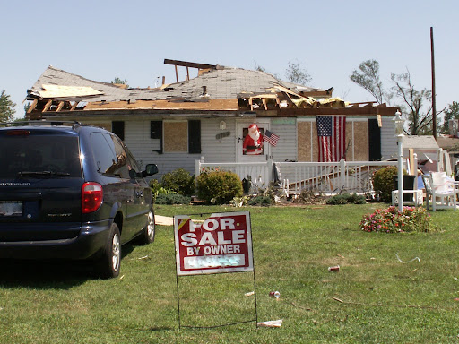
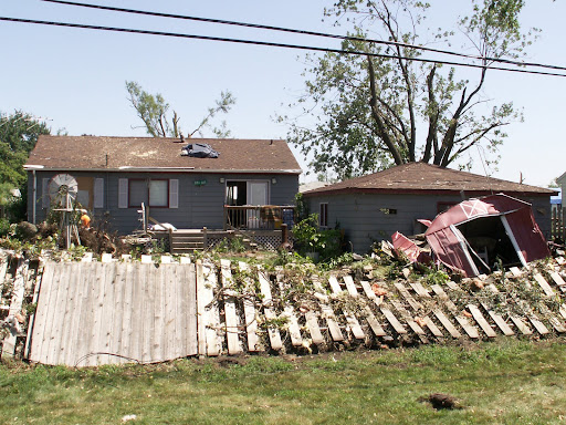
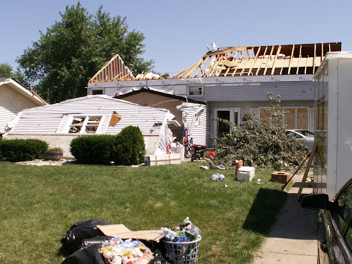
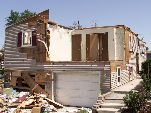
These are storm damage photos from the EF2 Tornado that hit Griffith, Indiana on August 4, 2008. Photo Credit: The Robin Storm /AM 1420 WIMS Severe Storm Intercept Team.


MARITIME NOTE

Salvors refloat grounded chemical carrier off Dutch tourist beach

Independent Dutch towage and salvage company Multraship and Belgian salvage operator URS Salvage & Maritime Contracting have refloated an Italian-flag chemical carrier which grounded off the Dutch coast on July 31.

The 5,045GT ‘Rubino’ grounded off a popular tourist beach at Zoutelande just after high tide. Bathers and swimmers were ordered out of the water to safety. The salvors, operating under an LOF agreement and working in close co-operation with the local authorities, mobilized an expert salvage team and three tugs, with others standing by, to refloat the vessel, which was thereafter towed to the Scheldepoort shipyard for inspection. No severe damage was found, and the vessel has been redelivered to its owners.

Updated: Search For Missing Teen Delayed Until Monday

Weather Conditions Too Dangerous For Divers

Rescue workers delayed the search for a missing 15-year-old until Monday due to bad weather conditions.Officers said the boy was swimming with friends on Saturday and didn’t come up after a strong current battered the group with high waves.Four other children got out of the water OK, rescuers said.A 911 call for help was made at 3:43 p.m. Saturday.A team of 50 people including the Coast Guard, Sheboygan Police and the Sheboygan Law Enforcement Dive team searched the lake.The search was called off at 6:30 p.m. Saturday due to conditions that would be too dangerous for divers.Rescuers continued their search Sunday but had to stop the search again due to the the weather.The search will begin again Monday.

Coast Guard Rescues 4 in Gulf of Mexico


RS

Tuesday, May 20, 2008

Atmosphere Threatened By Nitrogen Pollutants Entering Ocean

Atmosphere Threatened By Nitrogen Pollutants Entering Ocean

ScienceDaily (May 16, 2008) A large quantity of nitrogen compounds -- emitted into the atmosphere by humans through the burning of fossil fuels and the use of nitrogen fertilizers -- enters the oceans and may lead to the removal of some carbon dioxide from the atmosphere, concluded a team of international scientists led by Texas A&M University Distinguished Professor of Oceanography and Atmospheric Sciences Robert Duce.

The team of 30 experts from institutions around the world presented its conclusions in the current issue of the journal Science.

Human-caused atmospheric nitrogen compounds are carried by wind and deposited into the ocean, where they act as a fertilizer and lead to increased production of marine plant life. The increase in plant life causes more carbon dioxide to be drawn from the atmosphere into the ocean. This process results in the removal of about 10 percent of the human-caused carbon dioxide in the atmosphere, thus potentially reducing the climate warming potential, according to the team's paper.

However, some of the nitrogen deposited in the ocean is re-processed to form another nitrogen compound called nitrous oxide, which is then released back into the atmosphere from the ocean. Nitrous oxide is a powerful greenhouse gas itself -- about 300 times more powerful per molecule than carbon dioxide -- thus cancelling out about two-thirds of the apparent gain from the carbon dioxide removal, Duce explained. "But of course, the whole system is so complex that we're still rather unsure about what some of the other impacts might be within the ocean," he said.

In most areas of the ocean, nitrogen is the nutrient that limits the production of plant life, Duce said. So when all of the nitrogen in an area of the surface ocean is used up, no more plant life forms in that area. The team found that human-caused nitrogen deposits account for up to one-third of the external input of nitrogen into the ocean, and this increase in nitrogen available for the production of plant life causes more plants to form, Duce explained.

Oceanic plant life is produced from marine carbon (bicarbonate) in the ocean, and that amount of bicarbonate is in equilibrium with the carbon dioxide in the atmosphere. So when more bicarbonate is used up to produce marine plant life, it disrupts the equilibrium, and carbon dioxide is drawn down to the ocean from the atmosphere to restore the balance, Duce explained.

Thus, the human-caused nitrogen fertilization of the ocean removes some of the most important greenhouse gas -- carbon dioxide -- from the atmosphere, Duce said. This gain, however, is offset by the nitrogen compound, nitrous oxide, that also forms in the ocean due to the nitrogen fertilization and is re-emitted into the atmosphere as a powerful greenhouse gas, he added.

"If you don't consider the impact of human-caused nitrogen when trying to model climate change, you're missing a possibly significant part of the overall carbon cycle as well as the nitrogen cycle," Duce said. "So nitrogen deposition is potentially a very important factor in the climate change issue."

According to the team's calculations, about 54 million tons of nitrogen produced from human activities entered the ocean from the atmosphere in the year 2000. The team also found that the current nitrogen emissions are about 10 times what they were in 1860, Duce said. He added that the amount of nitrogen entering the atmosphere is expected to rise in the coming decades with the increase in demand for energy and fertilizers, and the team estimates that by the year 2030, human-caused nitrogen emissions will have risen to around 62 million tons per year.

"Clearly, there is much that we do not know about the extent and timescale of the impacts of this nitrogen deposition on the oceans and the subsequent feedbacks to the climate system," Duce said. "The implications are complex and interactive, and this is a very important issue that policy makers need to address and that scientists trying to model and understand the future of climate and climate change need to take into consideration."

WEATHER NOTE

Storm Chasers to Avoid Chasing Storms in Crane County
by Michael Stafford

NewsWest 9

A recent arrest in Crane County is keeping some storm chasers out of that part of West Texas.

You may recall last week, we showed you that Deputy arresting a professional storm chaser who was helping the Weather Service, and had refused to leave the area.

Now, the head of one storm chasing group says many professionals and volunteers plan to avoid Crane County in the future.

Those volunteers and professionals associated with the National Association of Storm Chasers and Spotters or NASCAS is the group we've been speaking with.

The acting Director, Warren Faidley, says in 20 years he's never had any problems with law enforcement.

In fact, he says troopers and officers have welcomed their help during times of severe weather, because they're helping protect the public.

Faidley tells NewsWest Nine they're going to avoid Crane County in the future, because they believe another arrest is immenent if they go there.

"Well, I think the main reason we're upset is because there were numerous witnesses and also video. So there was very little question of what actually occurred. I think with that kind of information you can draw a pretty fair conclusion. So, a lot of people I've spoken to from storm spotters to storm chasers and just everybody in between from researchers to news people from out of the area are pretty much going to try to avoid the area," Faidley said.

The Sheriff's Office has maintained the Deputy was in the right, and that the storm chaser was obstructing the highway, which is a Class B Misdemeanor.

Crane County does have its own volunteers from that area, but as Faidley says it's always good to have a professional organization assisting with the process when lives are in danger.

Only time will tell what affect this may have on Crane County when severe weather hits there in the future.

Ten Deadliest U.S. Tornadoes

1. 695…Tri-State Tornado…March 18, 1925
2. 317…Natchez, Mississippi…May 7, 1849
3. 255…St. Louis, MO…May 27, 1896
4. 203…Gainesville, GA…April 6, 1936
5. 216…Tupelo, Mississippi…April 5, 1936
6. 181…Woodward, Oklahoma…April 9, 1947
7. 143…Amite, Louisiana to Purvis, Mississippi…April 24, 1908
8. 117…New Richmond, Wisconsin…June 12, 1899
9. 115…Flint, Michigan…June 8, 1953
10. 114…Waco, Texas…May 11, 1953

Source: Christopher Burt’s book Extreme Weather…

MARITIME NOTE

Yachtsman's £40k boat sinks under the waves

A MAJOR salvage operation was underway last night to lift a £40,000 yacht which sank in the Menai Strait as its owner celebrated his 60th birthday.

Trevor Shirley was spending the weekend with his wife at Anglesey’s Gazelle hotel as a treat, when his precious boat slipped beneath the waves.

The couple had launched the yacht from Beaumaris on Friday, and sailed her in the Puffin Island area before mooring her opposite the hotel, where she could be seen in her full glory.

But when they came down from breakfast on Sunday the boat – called the Hindsight – had disappeared from view.

Mr Shirley, from Warrington, had spent the winter refitting the yacht to a gleaming condition.

Hotel owner Mary Brain was serving breakfast on Sunday morning when the couple realised something was wrong.

"They came down for breakfast and said let’s go and have look at the boat, but it wasn’t there," said Mary.

"It was launched on Friday and it must have gone down on Saturday night or Sunday morning," she said.

The couple were devastated when they realised that the mast sticking out of the water was the vessel that was their pride and joy.

A salvage team from Beaumaris Marine Services was called and divers checked the stricken vessel on Monday morning and sealed the fuel tanks.

Diver Scott Waterman from Quest Diving, Menai Bridge, inspected the hull on his first dive.

"The water was very clear on Monday and the sea was flat calm," said Scott, who has been involved in three other similar rescues.

"It was obvious the vessel hadn’t been involved in a collision as the hull was completely intact.

"She was still on the mooring but that hadn’t fouled so the reason for the sinking is still unknown," he said.

On Wednesday Scott and his team fixed lifting strops to the boat’s hull and attached 12 tonne flotation bags.

"We took gas down there and inflated the bags until she started to lift and that pulled her off the bottom," said Scott.

"Timing was quite important because it has to be done at slack water otherwise the boat’s volume causes too much drag," he said.

Yesterday onlookers praised the salvage team for their efforts as the boat partially resurfaced back into view.

"The boat came up in the upright position which is also very important for bringing it back to shore," said Scott.

As the high tide ebbed the salvage team were able to pump the water out of her hull and were hoping to refloat her on the next high tide today (Thursday).

Mr Shirley, who had spent months refurbishing his boat was to upset too talk about the incident but the salvage team believe the boat can be repaired.

RS

Tuesday, April 22, 2008

Jet Streams Are Shifting And May Alter Paths Of Storms And Hurricanes

Jet Streams Are Shifting And May Alter Paths Of Storms And Hurricanes

ScienceDaily (Apr. 17, 2008) The Earth's jet streams, the high-altitude bands of fast winds that strongly influence the paths of storms and other weather systems, are shifting--possibly in response to global warming. Scientists at the Carnegie Institution determined that over a 23-year span from 1979 to 2001 the jet streams in both hemispheres have risen in altitude and shifted toward the poles. The jet stream in the northern hemisphere has also weakened. These changes fit the predictions of global warming models and have implications for the frequency and intensity of future storms, including hurricanes.

Cristina Archer and Ken Caldeira of the Carnegie Institution's Department of Global Ecology tracked changes in the average position and strength of jet streams using records compiled by the European Centre for Medium-Range Weather Forecasts, the National Centers for Environmental Protection, and the National Center for Atmospheric Research. The data included outputs from weather prediction models, conventional observations from weather balloons and surface instruments, and remote observations from satellites.

Jet streams twist and turn in a wide swath that changes from day to day. The poleward shift in their average location discovered by the researchers is small, about 19 kilometers (12 miles) per decade in the northern hemisphere, but if the trend continues the impact could be significant. "The jet streams are the driving factor for weather in half of the globe," says Archer. "So, as you can imagine, changes in the jets have the potential to affect large populations and major climate systems."

Storm paths in North America are likely to shift northward as a result of the jet stream changes. Hurricanes, whose development tends to be inhibited by jet streams, may become more powerful and more frequent as the jet streams move away from the sub-tropical zones where hurricanes are born.

The observed changes are consistent with numerous other signals of global warming found in previous studies, such as the widening of the tropical belt, the cooling of the stratosphere, and the poleward shift of storm tracks. This is the first study to use observation-based datasets to examine trends in all the jet stream parameters, however.

"At this point we can't say for sure that this is the result of global warming, but I think it is," says Caldeira. "I would bet that the trend in the jet streams' positions will continue. It is something I'd put my money on."

The results are published in the April 18 Geophysical Research Letters.


WEATHER NOTE

It's Severe Weather Week

Severe Weather Awareness Week takes place April 21-25 this year, with the statewide tornado drills Thursday.

At 1:45 p.m. Thursday, the National Weather Service will issue a simulated tornado warning, and outdoor warning sirens will be activated. At 6:55 p.m., a second drill will take place in Scott County for families and second-shift workers.

“Everyone should practice their safety plans during Severe Weather Awareness Week,” said Chris Weldon, Scott County emergency management director. “There is no pattern to these things. A tornado can happen any day — without warning — and your preparation time is well spent.”

According to National Weather Service data, tornadoes have occurred in every Minnesota county at some time during the past 57 years. Scott County has experienced 12 tornadoes since 1950.

The Minnesota Department of Public Safety Division of Homeland Security and Emergency Management, along with the National Weather Service and the American Red Cross, sponsors Severe Weather Awareness Week annually to promote weather knowledge and planning. The Web site at www.severweather.state.mn.us, contains tornado safety information along with instructions on surviving thunderstorms, hail, straight-line winds, heat waves, floods and lightning. Links to the National Weather Service and Red Cross provide fascinating weather facts and a variety of downloadable resources for families, teachers and children.

Citizens prepped on disaster response
BY MICHAEL OPPERMANN
SPECIAL TO THE STAR-BANNER
Published: Monday, April 21, 2008 at 6:30 a.m.

OCALA — Marion County government, taking a proactive approach to terrorism, hosted a three-day training course under a grant from the Department of Homeland Security. Successful completion of the course, and an associated online component, granted educational credit to those who passed, better preparing them to respond to the possibility of terrorist events.

From Tuesday to Thursday, two instructors from the Texas Engineering Extension Service trained locals in recognizing, responding to and recovering from terrorist incidents.

The course, "Public Works: Planning for and Responding to a Terrorist/WMD Incident," was designed to help integrate training for terrorist events into existing emergency response plans.

Byrd Wilcox, safety hazard coordinator for the Public Works Bureau, said that while every emergency situation is unique, they all have common elements. Hurricanes, fires, chemical spills and terrorist threats can all be handled using the same crisis management techniques.

"All that this class is teaching the participants is that no matter how small or big [an event] is, it uses the same process," Byrd said.

Instructors Luke Stevens and David Pullen, both longtime public works officials, spent much of the course time discussing how communities react to emergencies and analyzing government response to previous terrorist events.

"One way we learn is from our own experiences. If we do that, then the depth of our knowledge will be limited by our experiences," Pullen said. "If we can learn from other people's experiences, then we broaden our knowledge and broaden the probability of a successful outcome."

Luiz Bisacchi, principle business analyst for public works in Hillsborough County, agrees, having attended the course to aid in the development of his community's hazmat protocols. "The Oklahoma case study was very helpful," he said. "Hopefully I can take some of [what I learned] back home and apply that to our plans."

COMMUNICATION IS KEY

Hot-button issues during the course were communications during an emergency situation and the integration of various agencies into the emergency response.

Lawrence Thacker, Marion County Public Works Bureau Chief, taught the course five years ago, and said that responding to an emergency "takes a lot of communication and a lot of coordination." The inability to do so complicates emergency situations and reduces the effectiveness of recovery efforts.

He feels the most effective way to safely deal with a crisis situation is to develop response plans well in advance and train workers in implementation of those plans.

"Safety is important to me because of my background," Thacker said. "I spent 18 years working underground in coal mines. I know what it is like when you've got your employees with you and you're trapped for 36 hours."

Attendee Andrea Nelson, of the transportation department's Public Education and Outreach section, is aware of the importance of effective communication.

"In a designated emergency I'm assigned to a public information function," she said, "so I think it's always good to know how your area will be interacting with others."

Nelson feels that increased training over the last few years has prepared government employees to better deal with emergencies.

"Setting up an incident command, determining who is in charge, identifying the functions that have to be filled and filling those, I think everyone here has been through the basics of that," she said.

INTEGRATION

Integration of services into a single command and communication structure is equally as important. While many note the disaster relief contributions of police officers, firemen and EMS personnel, they often overlook the contributions of public works employees and volunteers.

Stevens believes 90 percent of an emergency situation involves people from public works.

"Most people who look at an incident are looking at the initial response; it is putting everything back together that is the hardest part. The more that public works is involved, the better off you're going to be," he said. "Either the community is going to respond well together, or everybody is going to lose."

Robert Middleton, senior litter crew supervisor for solid waste, knows the value of integrating his efforts with an emergency response plan.

"We have a plan in place for natural disasters and terrorists," Middleton said. By preparing now, his people will be ready to fulfill their role when called to respond to an emergency situation.

TRAINED VOLUNTEERS

Wilcox said volunteers can be valuable assets in an emergency situation, but only if they are correctly integrated into the response plan. "Volunteers need to be trained and credentialed," he said.

Having people show up at a disaster site without going through proper channels disrupts the command structure and lines of communication, leaves people working at cross-purposes and potentially turns would-be volunteers into victims. Unstable ground, overhead debris, toxic fumes and other hazards can injure or kill the unprepared.

Wilcox suggests that members of the public who want to become involved in disaster response should follow the example of county government and plan ahead. Citizens should prepare disaster supply kits of food, water, flashlights and other necessities and review shelter-in-place and evacuation procedures that can be found on the Internet.

Proactive citizens also can join organizations such as the Red Cross, Salvation Army, Citizen Corps and Amateur Radio Emergency Service.

MARITIME NOTE

A salvage company is being sought to recover a tanker truck and logging equipment that sank to the bottom of Robson Bight, off northern Vancouver Island, last August.

A tugboat was used to move a barge that overturned in Johnstone Strait last August.A tugboat was used to move a barge that overturned in Johnstone Strait last August.
(Coleen Johnson)

A barge carrying the truck and equipment capsized in Johnstone Strait, an ecological reserve for killer whales.

B.C. Environment Minister Barry Penner said his government is concerned that leaking fuel may pose a threat to orcas and other marine life.

Penner and Loyola Hearn, Federal Minister of Fisheries and Oceans, announced Friday that they have decided to attempt a recovery operation following months of debate over what to do about the wreckage.

Penner said the first priority is to go after the equipment that contains the most fuel.

The barge was pushed to shore by the tugboat near Beaver Cove.The barge was pushed to shore by the tugboat near Beaver Cove.
(Coleen Johnson)

"That would be the fuel truck that had a tank that could hold up to 10,000 litres of diesel fuel," he said. "There's also a piece of equipment that we believe contains a significant amount of hydraulic fluid."

Penner said only a handful of companies in North America have the expertise to do the job.

The minister said the plan is to retrieve the equipment as quickly as possible, while minimizing From Holland and Knightthe impact on wildlife.

He said recent video footage of the sunken equipment shows it to be in decent shape.

Legal Notes From Holland and Knight

USCG – reminder to replace older EPIRBs

The US Coast Guard issued a press release reminding mariners that older model Emergency Position Indicating Radio Beacons (EPIRBs) that broadcast on 121.5 MHz or 243 MHz will not be monitored by satellite as of February 1, 2009. Effective that date, the satellites will only monitor for radio beacons broadcasting on 406 MHz. Some of the newer EPIRBs are equipped with embedded GPS, which will automatically signal the location of the distress. (4/18/08).


RS

Thursday, February 28, 2008

High Tech Cowboys of the Deep Seas: The Race to Save the Cougar Ace

I post this article because it presents a interesting backgrounder on people in the marine salvage community.

A industry that many have either never heard of or do not understanding what marine salvage companies actually do or go through to get the job done.

They are truly first responders and sometimes the only responders.


High Tech Cowboys of the Deep Seas: The Race to Save the Cougar Ace

Latitude 48° 14 North. Longitude 174° 26 West.

Almost midnight on the North Pacific, about 230 miles south of Alaska's Aleutian Islands. A heavy fog blankets the sea. There's nothing but the wind spinning eddies through the mist.

( Pix: The Cougar Ace lists at a precarious angle in Wide Bay, Alaska. Photo: Courtesy of US Coast Guard )

Out of the darkness, a rumble grows. The water begins to vibrate. Suddenly, the prow of a massive ship splits the fog. Its steel hull rises seven stories above the water and stretches two football fields back into the night. A 15,683-horsepower engine roars through the holds, pushing 55,328 tons of steel. Crisp white capital letters — COUGAR ACE — spell the ship's name above the ocean froth. A deep-sea car transport, its 14 decks are packed with 4,703 new Mazdas bound for North America. Estimated cargo value: $103 million.

Joshua Davis narrates this collection of photos and Coast Guard video taken during Titan Salvage's attempt to save the Cougar Ace.

(Video produced and edited by Wired's Annaliza Savage and Michael Lennon. Clips and photos courtesy of US Coast Guard and Titan Salvage.)

On the bridge and belowdecks, the captain and crew begin the intricate process of releasing water from the ship's ballast tanks in preparation for entry into US territorial waters. They took on the water in Japan to keep the ship steady, but US rules require that it be dumped here to prevent contaminating American marine environments. It's a tricky procedure. To maintain stability and equilibrium, the ballast tanks need to be drained of foreign water and simultaneously refilled with local water. The bridge gives the go-ahead to commence the operation, and a ship engineer uses a hydraulic-powered system to open the starboard tank valves. Water gushes out one side of the ship and pours into the ocean. It's July 23, 2006.

In the crew's quarters below the bridge, Saw "Lucky" Kyin, the ship's 41-year-old Burmese steward, rinses off in the common shower. The ship rolls underneath his feet. He's been at sea for long stretches of the past six years. In his experience, when a ship rolls to one side, it generally rolls right back the other way.

This time it doesn't. Instead, the tilt increases. For some reason, the starboard ballast tanks have failed to refill properly, and the ship has abruptly lost its balance. At the worst possible moment, a large swell hits the Cougar Ace and rolls the ship even farther to port. Objects begin to slide across the deck. They pick up momentum and crash against the port-side walls as the ship dips farther. Wedged naked in the shower stall, Kyin is confronted by an undeniable fact: The Cougar Ace is capsizing.

He lunges for a towel and staggers into the hallway as the ship's windmill-sized propeller spins out of the water. Throughout the ship, the other 22 crew members begin to lose their footing as the decks rear up. There are shouts and screams. Kyin escapes through a door into the damp night air. He's barefoot and dripping wet, and the deck is now a slick metal ramp. In an instant, he's skidding down the slope toward the Pacific. He slams into the railings and his left leg snaps, bone puncturing skin. He's now draped naked and bleeding on the railing, which has dipped to within feet of the frigid ocean. The deck towers 105 feet above him like a giant wave about to break. Kyin starts to pray.

Jackson Hole, Wyoming, 4 am.
A phone rings. Rich Habib opens his eyes and blinks in the darkness. He reaches for the phone, disturbing a pair of dogs cuddled around him. He was going to take them to the river for a swim today. Now the sound of his phone means that somewhere, somehow, a ship is going down, and he's going to have to get out of bed and go save it.

It always starts like this. Last Christmas Day, an 835-foot container vessel ran aground in Ensenada, Mexico. The phone rang, he hopped on a plane, and was soon on a Jet Ski pounding his way through the Baja surf. The ship had run aground on a beach while loaded with approximately 1,800 containers. He had to rustle up a Sikorsky Skycrane — one of the world's most powerful helicopters — to offload the cargo.

Rich Habib, Senior Salvage Master
Photo: Andrew Hetherington

Ship captains spend their careers trying to avoid a collision or grounding like this. But for Habib, nearly every month brings a welcome disaster. While people are shouting "Abandon ship!" Habib is scrambling aboard.

He's been at sea since he was 18, and now, at 51, his tanned face, square jaw, and don't even try bullshitting me stare convey a world-weary air of command. He holds an unlimited master's license, which means he's one of the select few who are qualified to pilot ships of any size, anywhere in the world. He spent his early years captaining hulking vessels that lifted other ships on board and hauled them across oceans. He helped the Navy transport a nuclear refueling facility from California to Hawaii. Now he's the senior salvage master — the guy who runs the show at sea — for Titan Salvage, a highly specialized outfit of men who race around the world saving ships.

(Full Story Wired Magazine)


MARTIME NOTES:

Messing About In Ships Podcast


Messing About In Ships Podcast #12 - Special Interview of US Coast Guard Rescue of Sailors Aboard the Yacht Sean Seymour II

February 25, 2008, 4:33 am
Filed under: podcast, shownotes

Here is the inspiring interview with the US Coast Guard helicopter rescue crew that saved the lives of three sailors aboard the yacht Sean Seymour II.

File Download:Messing About In Ships 12 - Special Interview

Interviewees:

  • Aviation Survival Technician Second Class Drew D. Dazzo, H-60 Rescue Swimmer
  • Lieutenant Commander Nevada A. Smith, H-60 Aircraft Commander
  • Lieutenant Junior Grade Aaron G. Nelson, H-60 Copilot
  • Aviation Maintenance Technician Second Class Scott D. Higgins, H-60 Flight Mechanic

Final log entry by Jean Pierre de Lutz, owner of Sean Seymour II

Robin Storm blog: Saved from the Angry Atlantic

Watch for future episodes with interviews with the C130 flight crew and the Sean Seymour II captain/owner.


RS