Showing posts with label NHC. Show all posts

Wednesday, February 13, 2008

U.S. aims to give wake-up alerts on storms

By Jim Loney

MIAMI (Reuters) - In the not-too-distant future, the U.S. government would like to be able to wake up residents in the middle of the night when a hurricane or tornado threatens, perhaps by sounding the alarm on a cellphone.

The birth of a twister or the sudden, overnight intensification of a hurricane while people are sleeping, are the nightmare scenarios facing storm forecasters as they lay plans to strengthen America's natural disaster defenses.

"I'm worried about waking you up," Mary Glackin, a Bush administration official responsible for the day-to-day operations of the National Oceanic and Atmospheric Administration, said on Tuesday. "I call that completing the forecast."

The U.S. government is ready to spend more money on tracking satellites, sea buoys and research on hurricanes, Glackin said as she briefed south Florida officials on the administration's proposed fiscal year 2009 budget.

The disastrous 2004 and 2005 Atlantic hurricane seasons sent shock waves through global energy, insurance and commodities markets. Four powerful hurricanes struck Florida in 2004, causing a combined $35 billion in damage.

In 2005 a record-breaking 28 tropical cyclones formed, including some of the most intense hurricanes on record. Katrina killed 1,500 people and caused $80 billion in damage when it swamped the U.S. Gulf coast, bursting the levees protecting New Orleans and flooding the famous jazz city.

One of the biggest threats from hurricanes is the explosive intensification of a cyclone close to shore after residents have gone to bed, shortening the time available to safely evacuate millions of people from the crowded Atlantic and Gulf of Mexico coasts.

WAKE-UP CALL

Bill Read, the new director of the National Hurricane Center, said he would like to see a wake-up system, perhaps Internet-based and delivered by cellphone, within a decade.

"Look what can be delivered by cellphone now," Read said. "We ought to be there in 10 years."

In order to improve hurricane intensity forecasts, NOAA plans to deploy three new hurricane-monitoring buoys at sea this year, bringing to 15 the number in the Gulf of Mexico, Caribbean and Atlantic. They can measure wind speeds, wave heights, sea temperatures and other critical data.

Read said he hopes for a 3 percent yearly increase in the accuracy of intensity forecasts, the same as forecasters have been able to achieve in predicting hurricane tracks. The aim is to buy residents a little extra time to react to a storm.

"We're not going to solve the intensity problem if we don't do the research," he said.

The agency's budget for hurricane-hunter airplane flights into hurricanes is increasing, and it plans to equip a Gulfstream-IV jet with a new Doppler radar system, giving forecasters better data on a storm's wind field, Glackin said.

Researchers eventually hope to deploy unmanned aircraft like those used by the U.S. military in Iraq for hurricane research missions that are "dirty, dull or dangerous," she said. Such a drone was sent into Hurricane Noel last year.

The fiscal year 2009 budget, proposed by President George W. Bush and subject still to Congressional approval, would boost funding from $3 million to $6.3 million for the drones. Glackin said full deployment is "several years down the road."

The 2009 spending plan includes a huge $242 million increase for the GOES-R (Geostationary Operational Environmental Satellite) program, which is scheduled to put a new string of satellites into orbit starting in 2014.


Monday, January 28, 2008

NOAA Selects Bill Read as New National Hurricane Center Director

He is smiling now! Hope it stays that way! Good Luck Bill Read!

January 25, 2008

(Bill Read at the National Hurricane Center forecast desk.)

+ High Resolution (Credit: NOAA)

NOAA officials today named Bill Read as the new director of its Tropical Prediction Center, which includes the National Hurricane Center and two other divisions, in Miami. Read has served as the center’s acting deputy director since August 2007.

“Bill has what it takes be the nation’s hurricane center director. He’s spent 30 years of his career as a weather professional with NOAA dedicated to protecting lives from severe weather, much of it hurricanes and tropical storms,” said retired Navy Vice Admiral Conrad C. Lautenbacher, Ph.D., under secretary of commerce for oceans and atmosphere and NOAA administrator. “Bill has been a trusted consultant to emergency managers in and around Houston and I’m sure he will foster that type of goodwill in communities vulnerable to hurricanes. He will find the job as rewarding as it is demanding.”

Tropical storms and hurricanes have frequently played a major role in Read’s professional life. Read and his team were at the forefront in July 2003 as Hurricane Claudette made landfall on the Texas coast. He also was part of the Hurricane Liaison Team at the National Hurricane Center in Miami when Hurricane Isabel came ashore on the Outer Banks of North Carolina and raced northeast in September 2003.

Read was appointed to direct the Houston/Galveston weather forecast office of NOAA’s National Weather Service in 1992 and led it through the challenges of the National Weather Service modernization and restructuring program in the mid 1990s.

“Bill brings a wealth of experience in meteorology and management to this position. He has a clear understanding of the needs of staff, the emergency management community and the public in fulfilling our mission of saving lives and property,” said Jack Hayes, director of NOAA’s National Weather Service. “Bill has a proven track record of pulling people together – from the forecaster to the emergency manager – as severe weather threatens.”

Prior to joining NOAA’s National Weather Service, Read served in the U.S. Navy, where his duties included an assignment as an on-board meteorologist with the Hurricane Hunters. He began his career in 1977 with the National Weather Service test and evaluation division in Sterling, Va., developed his forecasting skills in Fort Worth and San Antonio, Texas; and, served as severe thunderstorm and flash flood program leader at the National Weather Service headquarters in Silver Spring, Md.

NOAA’s Tropical Prediction Center contains three divisions – 1.) the National Hurricane Center provides forecasts of the movement and strength of tropical weather systems and issues watches and warnings for the U.S. and surrounding areas, 2.) the Tropical Analysis and Forecast Branch provides support for satellite and radar analyses, and 3.) the Technical Support Branch provides support for the Center’s computer and communications systems and develops new techniques for tropical cyclone and tropical weather analysis and prediction.

The National Oceanic and Atmospheric Administration, an agency of the U.S. Commerce Department, is dedicated to enhancing economic security and national safety through the prediction and research of weather and climate-related events and information service delivery for transportation, and by providing environmental stewardship of our nation's coastal and marine resources. Through the emerging Global Earth Observation System of Systems (GEOSS), NOAA is working with its federal partners, more than 70 countries and the European Commission to develop a global monitoring network that is as integrated as the planet it observes, predicts and protects.

ILLINOIS TORNADO TALLY 2007 - a Quiet Year

The tornado statistics for Illinois for 2007 are as follows:

JAN 0
FEB 0
MAR 4
APR 2
MAY 5
JUN 4
JUL 0
AUG 2
SEP 4
OCT
2
NOV 0
DEC 0
TOTAL 23

By EF Scale
EF0 22
EF1 1
EF2 - EF5 0

Total by NWS office area of responsibility
Chicago (northeast/north central IL) 5
Quad Cities (northwest IL) 3
Lincoln (central/southeast IL) 6
St. Louis (southwest IL) 7
Paducah (southern IL) 2

The 30 year running annual average for the state of IL from 1978-2007 is 41.

NWS CHIGAGO/ROMEOVILLE - Looking for River Watchers

River Watchers Wanted

The National Weather Service (NWS) in Chicago/Romeoville, IL is looking for individuals that live or work along the Kankakee River to become part of a river watcher network. Ice jams can result in rapid and devastating flooding. Although the NWS does monitor a small number of automated river gages, they typically do not accurately reflect the current conditions upstream and downstream due to the isolated nature of ice jams. It is also important to know extent of the current ice cover and conditions. That kind of information can only be obtained from visual observations. Under no circumstances are river watchers to actually go out on the ice! Your safety is important to us. Observations should be made from a safe location on the bank or perhaps from your home.

River watchers will receive basic training that will cover ice formation and ice reporting procedures. We hope to expand the network to other rivers in northern Illinois prone to ice jam flooding including the Rock and Fox Rivers.

If you are interested please contact Bill Morris, Hydrologist at the National Weather Service Chicago/Romeoville office. Please include your name, address, phone number, and email.


211 WEATHER CENTER

State Unveils 211 Storm Emergency Number

New Number Aims To Reduce Calls To 911

BOSTON --
There's a new phone number to call during storms or disasters in Massachusetts: 211. Officials at the Massachusetts Emergency Management Agency said 211 is designed to reduce the number of non-emergency calls made to 911.

By dialing 211, people can get updated disaster information and post-disaster programs, as well as volunteering and donation opportunities. The 211 call center operates weekdays 8 a.m. to 8 p.m., providing information about social services. It can be staffed around the clock during emergencies. The state is operating the 211 system with the Council of Massachusetts United Ways.


TORNADO WARNINGS
From Journal Sentinel readers
Jan. 26, 2008

Use phones to create a better system for severe weather emergency warnings

We live in the Town of Dacada, east of Random Lake. There are no sirens in our area, and back in 1996, we had a "tornado." It was called "straight-line winds," and we lost our 40-by-70-foot barn, and a cow was killed when the barn went down.

Earlier that night, the storm was in the Dakotas, and then it went through Minnesota and east into Wisconsin. It hit the Random Lake region around 2 a.m.when everyone was asleep. Thirteen barns went down that night.

Our answer to the problem of an audible warning siren is to set up a system that will warn people who are sleeping or out of earshot of sirens. The phone company could set up a system to send 15 fast rings, awakening residents to alert them to the approaching danger. Residents then could turn on the radio or television to find out what they should do.

This system also could be used during the daylight hours to alert the elderly who might not have the radio or television on. Neighbors without phones could be warned by their neighbors, and even cell phones could be notified. This should solve the problem without the huge expense of a siren system.

Jerry and Kathy Daddato
Dacada

TYPHOONS 2007

NW Pacific Typhoons 2007 Summary of 2007 NW Pacific Typhoon Season and Verification of Authors' Seasonal Forecasts. Published 9th January 2008

MARITIME NOTES FROM HOLLAND AND KNIGHT

New York – freshly squeezed

The US Coast Guard issued a press release stating that, on January 24, the orange-juice tanker ORANGE SUN collided with the dredge NEW YORK in Newark Bay. The US Coast Guard also issued a video release which you may find interesting. No injuries were reported. The incident is under investigation. A subsequent press release reports on steps take to minimize the impact of the hydraulic fluid that was released into the water and the initial survey of the damaged dredge. (1/26/08).

USCG – ISPR report to be released

The US Coast Guard issued a press release stating that the Incident Specific Preparedness Review (ISPR) Phase I report will be released in San Francisco at 1:00 p.m. local time on Monday, January 28. The report concerns the first two weeks of the response operation to the COSCO BUSAN oil spill. It does not address the cause of the spill, only the preparedness for and response to the spill. A second report on the remainder of the response will be released at a later time. (1/25/08).

San Francisco Bay – update n COSCO BUSAN clean-up

The Unified Command issued a news release providing an update on the clean-up of the oil spill from the COSCO BUSAN. Reading between the lines, it appears that the active response is largely complete. (1/24/08).


RS

Saturday, December 1, 2007

US Coast Guard HH-60 crew receives award for May 7th rescue

Its confirmed, on December 19th the four US Coast Guard HH-60 crew members will receive awards for the extraordinary rescue of the crew of s/v Sean Seamour II last May 7th.

The vessel caught in a sub-tropical depression subsequently named Andrea, was further battered by a rogue wave estimated above 100 feet approximately 200 miles off Cape Hatteras North Carolina.
rom left to right, swimmer Drew Dazzo who in extraordinary circumstances managed to bring us to safety, Petty Officer Scott Higgins who saved the day bringing all aboard with a frayed cable (so reminiscent of the end of Kevin Costner' film "The Guardian"), "steel nerves" Lt. j.g. Aaron Nelson who followed the fleeting sea-anchorless life-raft in winds over 70kts, and finally, Lt. Comdr. Nevada Smith who took upon himself to undertake this rescue in perilous operational conditions (for those who may have seen Kevin Costner's "The Guardian", he played the role of co-pilot Krausse). Swimmer Drew Dazzo in the helicopter resting before being evacuated with us to Cherry Point Military hospital for injuries sustained during our rescue, Lt. Comdr. Nevada Smith supervising our transfer while coordinating with operations. It is difficult to find words of appreciation, even so many months later, for the commitment of these heroes as there is no doubt failing them we would not be here to extol their dedication. Neither should we forget the C130 crew who miraculously found us among the seventy foot waves,but also the three ambulance teams, three hospital teams and the commander of Cherry Point Military Hospital who mobilized the disaster relief of the American Red Cross to help us through this crisis. Finally, a moment of silence in remembrance of the crew of s/v Flying Colors that dissapeared eighty miles off our starborard, Captain Trey Topping, Rhiannon Borisoff, Jason Franks and Christine Grinavic, likely pitchpoled by the same rogue wave amplified by their closer proximity to the Gulf Stream.


Robin Storm previous s/v Sean Seamour II posts:

Summary of Action for CG6014 for the S/V SEAN SEAMOUR II- REDUX - Plus
WebExclusive EPIRBs and the s/v Sean Seamour II - Part III

WebExclusive EPIRBs and the s/v Sean Seamour II - Part II
EPIRBs and the s/v Sean Seamour II
NHC Report on Subtropical Storm Andrea
Cheating Death On The High Seas
The s/v Sean Seamour II & The Hatteras Trench
High Sea's Update On Sean Seamour II
The Story of the Sailing Vessel Sean Seamour II

gCaptain previous s/v Sean Seamour II posts:
gCaptain Exclusive - Sailing in Severe Weather
Lessons Learned


WEATHER NOTE:

CHICAGO - S N O W!

Thanks Jean!

RS

Friday, November 9, 2007

NOAA celebrates 200 years of science

Contributed by: NOAA News on 11/7/2007

(NOAA meteorologists Tom Schlatter and Nikki Prive test their skills on a mirror nephoscope, an antique instrument used to determine the direction and relative speed of cloud motion.

The instrument will be part of an old-time weather station recreated for a public celebration this Friday at NOAA's research center in Boulder. Provided by: NOAA)

NOAA's (National Oceanic and Atmospheric Administration) Boulder campus will celebrate and commemorate the agency's 200-year legacy in science with a dedication ceremony, public activities, and teacher training from 9:30 a.m. to 3:30 p.m., Friday, Nov. 9. All activities will take place at the agency's David Skaggs Research Center at 325 Broadway.

NOAA is hosting the public event as part of a year-long celebration to commemorate its 200 years of science, service and stewardship to the nation. Boulder mayor Mark Ruzzin and other local leaders will participate in the event.

"It all started in 1807 with President Thomas Jefferson'svision to support his fledgling nation's economy by ensuring safe maritime commerce. He accomplished this by creating the Survey of the Coast, the first federal science agency and the precursor to NOAA's navigation services," said Tim Keeney, NOAA deputy assistant secretary for oceans and atmosphere. "With his intense interest in weather and climate, Jefferson would certainly appreciate the world-class scientific community here in Boulder."

Keeney will present an award to U.S. Rep. David Skaggs, former congressman from the Boulder area, for his role in consolidating the agency's Colorado groups into the NOAA center in the late 1990s. Susan Graf, president and chief executive officer of the Boulder Chamber of Commerce, will accept an award for the Chamber's role in attracting the federal labs to Boulder in the early 1950s.

The day's events will begin at 9:30 a.m. with the dedication of a memorial marker placed by NOAA's National Geodetic Survey in the gardens just outside the main entrance on the west side of the building. At 10:30 a.m., visitors will be treated to a "Science Showcase" of new activities and demonstrations, many with a historical focus. Teachers are invited to visit the demos and participate in a special in-service training on Earth science.

Visitors will be able to follow a virtual underwater explorer through four of NOAA's marine sanctuaries, travel aboard a survey ship mapping the coastal ocean floor, mop up a disastrous oil spill, and experience the devastation algae can wreak during a red tide.

For real-world experience, share an expert's view of Boulder's fickle weather as a National Weather Service forecaster walks through a year of big storms. Get a preview of the upcoming weekend weather, spiced with fascinating insider trivia about Front Range climate. Then stop by an old-time weather station to check out a mirror nephoscope, a microbarograph, a Parisian thermograph, and other antique instruments with strange names that meteorologists used to track weather long before computers existed.

NOAA's Boulder lab is the best place in the world to see how scientists measure carbon dioxide levels around the globe, including Boulder County's carbon "footprint." Air-filled flasks arrive daily from remote corners of the planet to be analyzed in Boulder. The most powerful software to understand the world carbon cycle was launched right here last spring and produces colorful maps of atmospheric carbon levels daily.

On the space-weather front, guests will be able to look back through the ages to early evidence of sunspots and find out how they are related to spectacular auroras, or Northern Lights, which are sometimes visible here in Colorado.

Science on a Sphere will display brilliant global presentations of tsunamis, El NiƱo, a warming world, and what planet Earth looked like 600 million years ago.

Fresh baked goods will be on sale to benefit the Denver Botanic Gardens' certificate program in botanical art and illustration. Coffee will be provided at no charge by a local vendor.

Visitors must stop at the Visitor Center at the Rayleigh Avenue entrance before passing through the gate. Those 16 years old and over should bring a valid state or federal photo ID.

The National Oceanic and Atmospheric Administration, an agency of the U.S. Commerce Department, is celebrating 200 years of science and service to the nation. From the establishment of the Survey of the Coast in 1807 by Thomas Jefferson to the formation of the Weather Bureau and the Commission of Fish and Fisheries in the 1870s, much of America's scientific heritage is rooted in NOAA.

NOAA is dedicated to enhancing economic security and national safety through the prediction and research of weather and climate-related events and information service delivery for transportation, and by providing environmental stewardship of our nation's coastal and marine resources. Through the emerging Global Earth Observation System of Systems (GEOSS), NOAA is working with its federal partners, more than 60 countries and the European Commission to develop a global monitoring network that is as integrated as the planet it observes, predicts and protects.

NOAA: www.noaa.gov

NOAA Boulder 200th celebration: http://www.boulder.noaa.gov/events/noaa200

Weather Notes

"England: Storm surge flooding likely for eastern England"


[Nov 8 London]--Forecasters at the Met Office are providing the Environment Agency with the very latest weather information, ahead of a predicted storm surge down the North Sea.

A combination of north-westerly winds exceeding 50 m.p.h., low pressure and high tides could lead to severe flooding in the east of England. Areas at greatest risk are the Broads and the coast south of Great Yarmouth including Lowestoft and Felixstowe.

Sky News Video on British flood threat!


Update on Mexican floods!

By
Arthur Rabjohn MEXICO: Tens of thousands of Mexicans are threatened by ailments ranging from colds, respiratory illnesses and foot fungus. Authorities fear outbreaks of epidemics like cholera due to a lack of running water. Standing water attracts mosquitoes, carrying infectious diseases such as dengue. Government official said that fumigation of waterlogged areas would start in the next few days to reduce the risk of diseases.

Crocodiles and snakes taking to flooded streets are posing a new risk, as the reptiles have started swimming along flooded streets. The floods, caused by rivers overflowing after heavy rain, killed at least 3 people, damaging crops, homes, businesses and infrastructure. A further 4 people were killed, and 21 others were missing as a result of a huge mudslide.


Maritime Notes

Ouch! Here are some pix's from the USCG on the Cosco Busan collision with the Bay Bridge!


M/V Cosco Busan Allides With San Francisco Bay Bridge
SAN FRANCISCO (Nov. 7, 2007)- The motor vessel Cosco Busan, a 900-foot container carrier, allided with one of the towers of the San Francisco Bay Bridge Wednesday morning, prompting a response from the Coast Guard, CALTRANS, the city of San Francisco and several other state and local agencies. Coast Guard photo.


And finally and most exciting....

National Storm Chasers Convention 2008 - Denver, Colorado (Click on rwister for further details!)

The 2008 National Storm Chaser Convention will be held February, 16-18, 2008 in Denver!

Hello everyone!

Just a preliminary FYI for the upcoming 2008 National Storm Chaser's Convention. It will be held Feb 15-17 (President's Day weekend as usual) in Denver, CO at the Radisson Southeast (same hotel as last year). Check out www.chaserconvention.com in the coming weeks for updates and more details. Friday evening will be the traditional ice breaker where you can meet your favorite speakers. Saturday will be a day full of great speakers and Keynote Speakers at the evening banquet that you DO NOT WANT TO MISS!! Sunday will be a day of teachings on your favorite severe weather subjects, followed by a spotter training class conducted by the local NWS.

THIS IS THE 10TH ANNUAL CONVENTION AND IT WILL BE HUGE!!! EXPECT SOMETHING VERY SPECIAL TO HAPPEN!

Tune in by early December for the details.

Roger Hill and Tim Samaras

random7.<span class=


Be sure and register NOW and secure your seat at the largest gathering of storm chasers in the world!


RS

Thursday, October 18, 2007

The S/V Sean Seamour III - The Green Boat


Well my good friend Jean Pierre deLutz the Master of the S/V Sean Seamour II, which ran into trouble and sank during Subtropical Storm Andrea has built another sailer. Can't seem to keep a good sail boat captain down for long.

We are still investigating the EPIRB malfunction.

By the way Jean, where did you put the "pitch pole roll-bar?" :-)

As Jean writes;

The Green Boat adventure

"After the loss of our Sean Seamour II between Cape Hatteras and Bermuda on May 7th 2007 see (Final Log), I was in quandary to define what Sean Seamour III should be.

My wife Mayke had long insisted that we should have a silent boat (no diesel engine to smell or hear) and a catamaran for it offers a stable platform. I had long insisted that we would never have a boat that could not right itself from a 180°. After May 7th, a Catamaran was longer a debate, but silent clean propulsion remained both her desire and my curiosity.

Living on the Mediterranean where wind is either overly abundant or non existent (sailing to Corsica is often motoring there), we opted for a Nauticat 33 motorsailor. A stable platform with a deep keel, decent sailing performance with its extended ketch rig, foremost, a great platform to experiment its transformation into a diesel-electric hybrid as a first step before, we hope a fuel cell electric drive. Through this blog we would like to share our ideas, trials and tribulations, as well as create an interactive repository of knowledge and references on the state of the art and where it may be going. Please don't hesitate to share and contribute, we are all breaking ground.

In the months ahead we will be looking at all the facets of going green. This means breaking down the technology blocks constitutive of a green system, looking at who and what is present and or emerging. We will study the performance and suitability for our project. We are also keeping a sharp eye on new technologies in related areas in an effort to see when and if technology migration, or perhaps we should use the term crossover, may come to benefit green boat adventures where ever they may be.

We hope players from all horizons will come and join our adventure, manufacturers and inventors, system integrators and installers, yards, craftsmen and mariners like us."

Note

We have been advise that the USCG Rescue crew will be decorated for this rescue shortly. The USCG story is posted here, Summary of Action for CG6014 for the S/V SEAN SEAMOUR II- REDUX - Plus, just an amazing rescue story.

I think we can all say congratulations to USCG LCDR Nevada Smith and his crew for a job very well done.

Weather Story UPDATE

A line of sereve thunderstorms crossed southern Illinois around 3 AM. The line delivered winds recorded up to 65 to 70 MPHs and up to 3 inches of rain. NOAA’s Storm Prediction Center reports about a dozen twisters had been reported by late Wednesday evening among the more than 138 reports of severe weather. Missouri State Highway Patrol reports two people are dead after a tornado tore apart a mobile home in rural Monroe County.

The threat of tornado's and even micro-bursts extends into today, Thursday, October 18, 2007.

In other Weather News from
Arthur Rabjohn;
:
GREECE: Wet weather warning sent
Authorities from around the country have been placed on alert for possible floods, particularly in the parts of southern and central Greece hit by devastating fires over the summer, with wet weather expected to start as of Friday. The National Meteorological Service (EMY) informed fire authorities and the Secretariat for Civil Protection about the deteriorating weather conditions. “From Friday afternoon until the middle of next week, we are expecting heavy rainfall across all of Greece,” said the head of EMY, Dimitris Ziakopoulos. Despite the low rainfall in the first half of October, firefighters were called to handle 42 calls of flooding across Greece, mainly in the Attica area. Fire authorities said all regional heads have been called to map out local possible danger points for flash floods in their district and to set up teams that will be on 24-hour standby.

INDONESIA: Fears of an imminent eruption prompted the evacuation of thousands of residents near Indonesia's Mount Kelud on Wednesday, but many flouted the order stayed at their homes around the Javanese volcano. The alert on the volcano, one of Indonesia's deadliest and located 90 km southwest of its second-largest city, Surabaya, was raised to maximum late on Tuesday, meaning it could erupt within 24 hours. Source: Reuters AlertNet

BANGLADESH: A powerful storm swept through southern Bangladesh killing at least 18 people in mudslides and house collapses and injuring 100, officials said on Tuesday. At least 20 fishing boats sank in the Bay of Bengal and at least 50 of their crew were still missing, fishing community leaders said. Source: Alertnet

RUSSIA: Volcano Bezymianny in Russia is erupting with SWVRC alert level 2. The GDACS alert level is Green.

SOUTH PACIFIC: A magnitude 6.4 earthquake hit deep under the South Pacific seabed between Fiji and New Zealand Wednesday. There were no reports of injury or damage.

USA: A magnitude 4.2 earthquake hit California's San Bernardino County early Tuesday, sending shudders across the region, authorities said.


RS

Robin Storm previous s/v Sean Seamour II posts:

Summary of Action for CG6014 for the S/V SEAN SEAMOUR II- REDUX - Plus
WebExclusive EPIRBs and the s/v Sean Seamour II - Part III

WebExclusive EPIRBs and the s/v Sean Seamour II - Part II
EPIRBs and the s/v Sean Seamour II
NHC Report on Subtropical Storm Andrea
Cheating Death On The High Seas
The s/v Sean Seamour II & The Hatteras Trench
High Sea's Update On Sean Seamour II
The Story of the Sailing Vessel Sean Seamour II

gCaptain previous s/v Sean Seamour II posts:
gCaptain Exclusive - Sailing in Severe Weather
Lessons Learned

Monday, October 8, 2007

Busy Pacific Storms

While its been extremely quiet in the Atlantic the Pacific is entirely another story.

To date there have been some 15 named storms and another three weather systems of interest harrassing the area. Unlike the Atlantic Hurricane season typhoons can run year round in the Pacific.


Tropical Cyclone Krosa now a tropical storm is now tracking toward China. At the last observation, on 2007/10/07 6:00 UTC, tropical cyclone KROSA is a Tropical Storm with maximum sustained wind speeds of 25 m/s (92 km/h, 50 knots) according to the Joint Typhoon Warning Center.
Meanwhile, another system Typhoon Lekima, triggered floods and landslides which battered Vietnam's central coast earlier this week and killed up to 34 people and left 19 others missing. Thousands of homes were destroyed in two central provinces of Ha Tinh and Quang Binh, Vietnamees officials reported on Sunday. Lekima was the fifth typhoon to hit Vietnam this season. Tug boats were stabilizing the M/V Aladdin Dream which ran aground during the storm.

Freak Waves?

Here is a interesting story from New Zealand on a reported "freak wave" in one of New Zealand's worse maritime accidents.

Sinking just a 'freak accident'
5:00AM Sunday October 07, 2007
By Michelle Coursey
An official report into one of New Zealand's worst maritime tragedies, the sinking of the Kotuku fishing boat in Foveaux Strait last year, attempts to lay blame where it shouldn't, say family members of the victims.

The 17-metre trawler capsized on May 13 last year, reportedly after being hit by two large waves, on its way back to Bluff from the Titi Islands, near Stewart Island.

Six people died in the incident - including members of three generations of one family - while three others narrowly escaped with their lives by swimming to a nearby island.

On board were members of the Topi family, a well-known clan in Bluff - Leslie Topi (known as Peter), 78, his daughter Tania Topi, 41, and his two grandsons Shain Topi-Tairi and Sailor Trow-Topi, both aged nine, all died; while Paul Topi and Dylan Topi both survived the accident.

Skipper John Edminstin also survived, but his friend Ian "Shorty" Hayward, 52, and crew member Clinton Woods, 34, perished.

Last week, the first preliminary report was released on the tragedy by the Transport Accident Investigation Commission, but those close to the victims are unhappy about its contents, and plan to tell the TAIC what they have got wrong.

Those who have seen it have had it "drummed" into them that they are not allowed to discuss its findings until after a meeting to be held this Thursday. The closed hearing will be held in Invercargill, where the three-member Commission will hear submissions from those affected.

All of those who spoke to the Herald on Sunday yesterday intended to be at the hearing, or make submissions via email on the content of the report.

But at least one family member, who did not wish to be named, said the conclusion of the findings was the part they found most objectionable, as it tried to "find something wrong" with various factors, including people's actions and the boat, to explain the incident.

"They've tried to find something to blame but it was a freak accident. They can't seem to accept there were two waves, and that's what did it."

While previous reports have speculated the boat may have been overloaded - it was carrying around 60 buckets of muttonbird on deck when it left the Titi Islands - the TAIC findings apparently do not say that was the cause.

Neither do they apportion blame to alcohol being consumed; however, they do make suggestions as to what might have been done by those onboard to survive.

"That just seems pointless. I guess they have to do it, because they said this report is meant to tell other people what not to do, but it's a bit late now."

The report includes much technical detail, including stability testing on the boat, and a close analysis of its seaworthiness. Some of the information in it has come as a surprise to family members, but then "we weren't on the boat" they say. And neither were the writers of this report, they add.

Edminstin did not wish to speak at length to the Herald on Sunday yesterday, preferring to save his comments on the tragedy for after the government reports were finalised.

TAIC hopes to release its final findings by the end of the year, but that will "depend on the extent of further work required following next week's hearing", chief commissioner Bill Jeffries said in a press release.

However, after that, another report will be put together by Maritime New Zealand, and Southland coroner Trevor Savage is waiting for both before deciding if an inquest into the deaths would be held.

Judy Hayward, who lost her husband Ian in the sinking, and who has since relocated to Melbourne, said every time someone mentioned the name of the boat to her "it brings it all up again", and she was looking forward to when "all of it has finished".

After reading the report, she would make her submission to the commission via email, but agreed that it was simply an accident.

"At the end of the day you can't change the sea. No amount of preparation can change the strength of the sea and no amount of reporting will make it [the accident] go away."

Another widow, Joyce Topi, who lost husband Peter, said she had not read the report because she didn't believe it needed to be written in the first place. "It's nobody's fault, it was an accident."

The Kotuku itself continues to sit rusting in the backyard of an old timber mill outside of Invercargill.

Edminstin still plans to burn the boat when it is returned to him - he has no use for it now.

"It should never have been lifted up," said Judy Hayward. "It was already a graveyard."


My favorite subject, USCG Rescue Teams.
2006 AIRSTA SAV rescue clips to music.


Weather Note

Chicago Weather for October? 88 degrees? Unheard of ! And what did the heat do the Chicago Marathon?

One dead, 250 hospitalized after heat-shortened Chicago Marathon Associated Press - October 7, 2007 5:43 PM ET

CHICAGO (AP) - A Michigan man died while running the Chicago Marathon as stifling heat and humidity forced race organizers to shut down the course midway through the race. Authorities say the 35-year-old man collapsed while running on the city's South Side and was pronounced dead at a Veteran's Affairs hospital.Some 250 people were taken to hospitals because of heat-related ailments.

The decision to turn runners around effectively ended the race for many thousands midway through the course. Organizers closed the second half of the course just before noon, four hours after the annual race started with temperatures already touching 73 degrees with 86% humidity. By 10 a.m., temperatures had already reached a race-record of 88 degrees.

The men's race was won by Kenya's Patrick Ivuti (eh-VOO'-tee). Ethiopia's Berhane Adere (buhr-HAYN' ah-DAHR') rallied to successfully defend her women's title.

Copyright 2007 The Associated Press. All rights reserved. This material may not be published, broadcast, rewritten or redistributed

RS

Friday, September 21, 2007

Update On Hurricane IVO and TD #10

Hurricane Ivo Continues Its Northward Trek

Hurricane Ivo, which at 11 a.m. EDT on Friday, Sept. 21 was a Category One storm with maximum sustained winds of 65 knots (75 miles per hour), continues to move north toward Baja, Calif., in this infrared image from the Atmospheric Infrared Sounder instrument on NASA's Aqua satellite. Ivo is expected to weaken to a tropical storm later today and make landfall in Baja, Calif., as a tropical storm some time on Monday, Sept. 24. The image, acquired at 5 a.m. EDT Sept. 21, shows large areas of strong convection surrounding the core of the storm (in purple).

Image credit: NASA/JPL

+ Larger view


Tropical Depression Ten Forms in the Gulf of Mexico

Tropical Depression Ten


Tropical Depression Ten, expected to become Tropical Storm Jerry later today, formed in the northeastern Gulf of Mexico south of the Florida Panhandle on Friday, Sept. 21, and is expected to make landfall somewhere in the U.S. Gulf Coast on Sept. 22. This infrared image from the Atmospheric Infrared Sounder instrument on NASA's Aqua satellite was acquired at 3:17 a.m. EDT Sept. 21, while the system was still subtropical. At 2 p.m. EDT Sept. 21, Tropical Depression Ten had maximum sustained winds near 30 knots (35 miles per hour), and was moving toward the northwest near 18 kilometers per hour (11 miles per hour). The AIRS image shows the temperature of the cloud tops or the surface of the Earth in cloud-free regions. The lowest temperatures (in purple) are associated with high, cold cloud tops that make up the top of the storm. The infrared signal does not penetrate through clouds. Where there are no clouds the AIRS instrument reads the infrared signal from the surface of the Earth, revealing warmer temperatures (red).

Image credit: NASA/JPL

+ Larger view (575Kb)

Keep Posted...

RS

Thursday, September 6, 2007

Henriette and Felix Update


Hurricane Felix (Again these are very early reports!)


Summary

At the last observation, on 2007/09/05 9:00 UTC, tropical cyclone FELIX is a Tropical Depression with maximum sustained wind speeds of 13 m/s (48 km/h, 26 knots). Within 100km of its eye there are 2.7 million people. Within 200km there are 8.4 million people.

The storm is affecting the provinces Valle in Honduras (144.2 thousand people), La Union in El Salvador (371.1 thousand people), Comayagua in Honduras (268 thousand people), La Paz in Honduras (127.3 thousand people), Francisco Morazan in Honduras (0.9 million people), Olancho in Honduras (341.3 thousand people), Yoro in Honduras (401 thousand people), Choluteca in Honduras (355.3 thousand people), El Paraiso in Honduras (275.2 thousand people), Chinandega in Nicaragua (364.4 thousand people), Esteli in Nicaragua (186.6 thousand people), Madriz in Nicaragua (97.8 thousand people), Nueva Segovia in Nicaragua (134.7 thousand people). The closest 6 cities are Tegucigalpa, Comayagua, Talanga, La Paz, Danl¡, El Para¡so.

FEMA National Situation Update

Atlantic/Caribbean/Gulf of Mexico:
Hurricane Felix
Tropical Depression Felix

Felix weakened as it moved into Honduras, all coastal watches and warnings are discontinued but flooding danger continues. Maximum sustained winds have decreased to near 30 mph, with higher gusts. The center of Tropical Depression Felix was located near Tegucigalpa. Heavy rain and isolated thunderstorms continue over Nicaragua and Honduras and could produce life-threatening flash floods and mud slides.


Hurricane Henriette


Summary

At the last observation, on 2007/09/05 18:00 UTC, tropical cyclone HENRIETTE is a Tropical Cyclone Category 1 with maximum sustained wind speeds of 33 m/s (120 km/h, 65 knots). Within 100km of its eye there are 505.6 thousand people. Within 200km there are 1.6 million people. The storm is affecting the provinces Sinaloa in Mexico (2.3 million people), Sonora in Mexico (1.9 million people). The closest 6 cities are Yaqui, Navajoa, Huatabampo, La Curva, Campo Cinco, Colonia Militar.

FEMA National Situation Update

Eastern Pacific:
Hurricane Henrietta

Henriette is a category one Hurricane on the Saffir Simpson scale. Little change in strength is forecast prior to landfall. Maximum sustained winds are near 75mph with higher gusts. Hurricane force winds extend outward up to 15 miles and tropical storm force winds extend outward up to 125 miles from the center. The government of Mexico has replaced the Hurricane Watch and Tropical Storm Warning with a Hurricane Warning along the coast of mainland Mexico from Topolobampo northward to Bahia Kino. Moisture form the remnants of Henriette should make it into the southwestern United States during the next few days.

FEMA National Situation Update

Other Tropical Activity - Atlantic
Low Pressure


A non-tropical area of low pressure is located about midway between Bermuda and the northeast Florida coast. The associated shower activity has become more concentrated east of the center. A tropical or subtropical depression could form from this system today as the system moves slowly and erratically. An Air Force Reserve Hurricane Hunter aircraft is scheduled to investigate the system this afternoon.

Maritime Note:

This is an interesting report on wind effects on ships. Thanks Dennis!

New Zealand – report wind effect on ships

The New Zealand Transport Accident Investigation Commission (TAIC) issued the report of its investigation into two recent incidents where strong winds caused restricted limit passenger vessels to heel excessively and lose directional control. The report recommends, among other things, that operators in areas subject to sudden strong winds implement maximum meteorological parameters. MAR 05-212 (8/23/07).


Stay Posted!

RS


Tuesday, September 4, 2007

Felix Inbound Nicaragua UPDATED

This is an updated report.

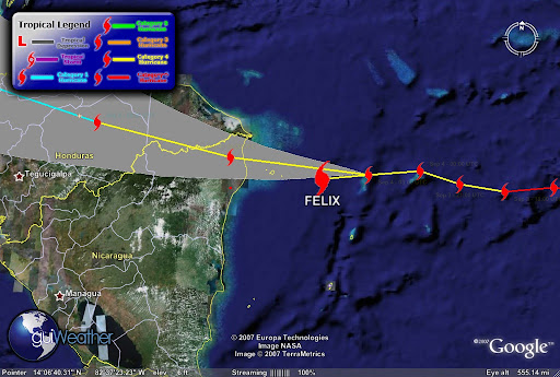
Hurricane Felix a Category 4 and gaining strength. The storms current position as of
Sep 4 - 06:00 UTC is approximately 93 miles/ 80 nautical miles (Latitude: 14.3 Longitude: -81.9 off the Nicaragua coastline.

According to guiWeather track (see track below). The storms track indicates that the storm is currently deviating from its westerly track slightly to the south and if it maintains course will pass north of Pureto Cabezas on the Nicaragua coastline. The storm is packing maximum winds of 150 mph with a pressure of 940 mb.

Felix is moving toward the west near
20 MPH/32 KM/HR. A south westward track with some decrease in speed expected. The storm has strengthened and may further strengthen before landfall. Hurricane Force winds extend outward up to 35 miles and Tropical Storm Force winds extend outward to 195 miles.

This is a very dangerous storm. The deep ring of red in the satellite photo below indicate
intense thunderstorm or intense convection activity ongoing.


The track below also indicates that Felix is driving slightly south of it westerly track and will drive deep into Central America and we can expect
tropical torrential rains that can cause major flooding and mud slides in mountainous and low lying areas.


According to press reports," local officials pleaded with residents of Honduras, Nicaragua, Belize and Guatemala to evacuate low-lying areas especially Honduras’ nine offshore islands and otherwise prepare for inevitable disaster". Tourist have been evacuating resort areas jamming area airports.

On the Pacific side...

Tropical Storm Henriette is very close to becoming a hurricane. Henriette is tracking for tourist resorts in Baja California after killing seven people, five of them children, in Mexico's Pacific coastal state of Chiapas. Local Civil Protection Services reported that Henriette dumped torrential rains in Guerrero state on Friday, triggering a rockslide that buried six people in their homes in the resort city of Acapulco. Another man was killed when his vehicle was crushed under another rock slide in jungle ravine in neighboring Chiapas State.


TS Henriette current storm position as of Sep 3 - 18:00 UTC tracking North/Northwest at Latitude: 19.8 / Longitude: -108.3 with maximum winds of 060 knots with gusts to 075 knots.


Keep Posted!

RS

Monday, September 3, 2007

The Persian Gulf and Hurricane Felix

Once again I am going to start the blog about something that this blog was not created for, politics and war.

However, serious rumors of war with Iran have now hit my industry and that is not a good sign.

Yes I have a political point of view. And since this is not a political blog I will keep my political views to myself.

There are a plethora of blogs both right wing and left wing that can confuse a group of rocket scientists, so just do a web search and knock yourself out if your all ready blindly deposed one way or the other.

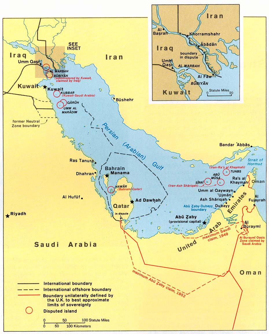
However as a professional marine salvor I wish to take a different approach in discussing the potential of going to war with Iran in the Persian Gulf .

The potential maritime and economic loss of war in the Persian Gulf to both sides as well as the rest of the world.

Most blogs and news reports focus on the ramification of going to war with Iran in terms of terrorism or in military terms. But there is another picture. The economic picture.
While I have no great love for the current Iranian regime and since I am sure, that most of the Iranian people do not wish to go to war with the United States, as most citizens of countries normally feel about going to war, unless they are attacked without just cause or buy a political hook, line and sinker. Yes we are not the only ones, try the German people during WWII and they paid a very heavy price, much heavier than anything we have ever paid.

While we are have the freedom of speech and opinion. Most of the time, none of us actually know what is really going on, but we all have some real interesting opinions. So I say to my readers, do not let the media or government meld with your mind, do your own research. And seriously research all sides then come to a conclusion.

Yes the United States Military is very capable of successfully striking Iran. Though we need to remember the British Falklands Island campaign. Ship losses took a heavy toll and we can expect the same thing in the Persian Gulf on both the military and merchant sides.

Daily in the Gulf there are some 30 merchant ships entering and exiting the Gulf every 24 hours. During both the Gulf War and the Iraq/Iran War the US and its Allies escorted some 9000 merchant vessel, even re-flagging some to the US Flag for additional protection. The Persian Gulf is a key economic waterway to the world.

Currently we have three Carrier Battle Groups operating in the Gulf. Depending on the mission each battle group can have as many as 12 or more combat ships within each of its groups. This is not just a strike force but a fleet protection force as well. Protection for both fleets, military and merchant.

Yes we know how and where to strike Iran and the Iranians know, we know, and they know how to strike back. Yes we are prepared to ensure that the Gulf remains open to the merchant fleet. You can also bet that the Iranians are prepared to attempt to close it down as well. They have done it before and odds are they will attempt it again.

So I end here. Not much has changed since the Iraq/Iran war except that weapons systems have advanced 10 fold and yes we have a huge advantage on that frront. But the same navigational and economic concerns and problems in the Gulf still exist.

Listed are some choice studies for my readers to start with. So as the political and media campaign to war starts remember, "do not let the media or government meld with your mind, do your own research" !


1. Iran-Iraq War 1980-1988
The Tanker War, 1984 - 1987

Much of Iraq's export capability was lost during the Iran-Iraq War, either to war-related damage or due to political reasons. In 1982, for instance, Syria (allied with Iran at the time) closed the 500-mile, 650,000-bbl/d-capacity Banias pipeline, which had been a vital Iraqi access route to the Mediterranean Sea and European oil markets. By 1983, Iraq's export capabilities were only 700,000 bbl/d, or less than 30% of operable field production capacity at that time.

Iran's revenue share fell after the 1978-79 Iranian Revolution, followed soon thereafter by the Iran-Iraq War for much of the 1980s. All Iranian onshore crude oil production and output from the Forozan field (which is blended with crude streams from the Abuzar and Doroud fields) is exported from the Khark Island terminal located in the northern Gulf. The terminal's original capacity of 7 million bbl/d was nearly eliminated by more than 9,000 bombing raids during the Iran-Iraq War.

The tanker war seemed likely to precipitate a major international incident for two reasons. First, some 70 percent of Japanese, 50 percent of West European, and 7 percent of American oil imports came from the Persian Gulf in the early 1980s. Second, the assault on tankers involved neutral shipping as well as ships of the belligerent states.

The tanker war had two phases. The relatively obscure first phase began in 1981, and the well publicized second phase began in 1984.


2. If Iran Provokes an Energy Crisis: Modeling the Problem in a War Game by James Jay Carafano, Ph.D. and William W. Beach

From December 2006 to March 2007, Heritage Foundation scholars conducted a computer simula­tion and gaming exercise that examined the likely economic and policy consequences of a major oil disruption in the Persian Gulf. The exercise utilized a realistic scenario, state-of-the-art macroeconomic modeling, and a knowledgeable team of subject-matter experts from government, business, aca­demia, and research institutes from around Wash­ington, D.C.

This project was a proof-of-principle investiga­tion that combined computer modeling and gaming to capture how U.S. decisions during a crisis might affect how global energy markets and the U.S. econ­omy adjust to sudden and significant disruptions of oil supplies. In this scenario, the United States responded to a crisis precipitated by an attempted Iranian blockade of the Strait of Hormuz.

3. The Future of Oil: Four Scenarios Standard & Poor's RatingsDirect

If anything underscores how geopolitical forces have played havoc with oil prices, it's the latest armed conflict in the Middle East, pitting the Israeli military against Hezbollah guerrillas in open warfare in Lebanon. Already heightened by the U.S.-led confrontation with Iran over its nuclear ambitions, fears about the stability of oil supplies have only increased since the Gaza bombings earlier in July and have intensified sharply since Israel began targeting Lebanon. The outcome is now even more uncertain than it appeared just a few weeks ago.

How long the conflict continues—and whether it spreads to surrounding countries—will determine the future of energy prices, at least in the short run. With Iranian President Mahmoud Ahmadinejad saying on July 25 that the fighting could trigger "a hurricane" of broader war in the Middle East, the prospects look dire to many observers—especially oil traders—around the world.

Having survived higher energy prices relatively unscathed so far, the U.S. economy is more sensitive to costlier oil now than it was a year ago. Inflation, even excluding energy, has accelerated, leading the Federal Reserve to raise interest rates 425 basis points in response. Consumers are already spending more than they earn. And Standard &Poor's expects the economy to slow down to 2.5% growth in gross domestic product in 2007 from an estimated 3.5% in 2006.

UNCERTAINTY PREVAILS. The falloff in U.S. growth means it takes a smaller shock to cause a recession than it did a year ago. Continued strong world oil demand, with usage in both China and Europe accelerating, will continue to put rising pressure on oil supplies despite a U.S. slowdown, thus raising the odds of an oil price surge causing a U.S. recession.

Whether the current Mideast conflict causes a recession depends mostly on how big the impact on oil supplies and prices becomes. This is still highly uncertain. At Standard & Poor's, we continue to believe that the most likely outcome is that cooler heads will eventually prevail and that oil prices will drop back from current peaks. (Of course, there are other, non-military factors—like hurricanes or production disruptions on the order of BP's [BP ] Aug. 6 closure of its Prudhoe Bay field in Alaska—that could have an effect as well [see BusinessWeek.com, 8/7/06, BP's Pipeline Trouble].)

4. TANKERS AT WAR - JAMES H. RAND 1984-1987
Published: 12 January 2001 00:00
Updated: 05 July 2006 17:09

In his first ‘Chairman’s Report’, in the 1984 Annual Report, Jim Rand noted that “promotion of free enterprise and safety at sea are key issues for INTERTANKO”.

Further, he added that “free competition has also for centuries been a cornerstone of American society”. Perhaps someone should have told the United States Congress. Although, for a change, no flag preference proposals gained any speed in Congress, American proposals for taxation of foreign shipping were tabled in 1986. These proposals required tax returns from foreign owners and planned to levy taxes according to American theories of the owner’s domicile rather than the ship’s flag - a burdensome intrusion.

American tax was not the main feature of this time. This was provided by the more spectacular events in the Middle East Gulf, where the Iran-Iraq War now made the waters of the Gulf one of its main theatres. Both sides routinely attacked non-military shipping regardless of its association in any way with either of the combatants.

In 1984, eleven Very Large Crude Carriers (VLCCs) were damaged beyond repair by military strikes. More seriously, 25 sailors were killed and 25 more injured in the attacks. Some tanker owners refused to sail their ships to load at the Iranian export terminal at Kharg Island, despite high freight rates obtainable.


Back to the Weather!

Latest on Hurricane Felix:

Felix becomes a Category Five!!

Felix's projected path is just north of Honduras, then Belize one more time!


And


- - click on image for animation - -

And

[full basin map of tropical cyclone activity]


More From Aruba!


Keep you posted!

RS