Showing posts with label snow. Show all posts

Thursday, February 7, 2008

FLOODS, TWISTERS, SNOW AND THE RIVERDANCE

Wild weather returns

State hit again with storms, flooding
February 6, 2008

In January, people living along the Tippecanoe River were flooded out of their homes by a combination of snowmelt and heavy rain.

One month later, it's happening again, with more rain causing flooding in the area.The weather hasn't spared Central Indiana, either, as storms smacked the area with heavy rain and a possible tornado Tuesday night. Indiana's strangely volatile weather, which in the past month has seen swings from snow to thunderstorms, and tornadoes to snow and sleet, has moved back to an imitation of spring. A wave of thunderstorms crossed Central Indiana on Tuesday, causing damage in Putnam County about 9:30 p.m.

The Web site of the National Weather Service reported that U.S. 231 south of Greencastle was blocked by debris and that trailers, cars and trees were damaged at U.S. 231 and U.S. 36. There also was a report of a possible tornado west of Bainbridge.

Indiana State Police at the Putnamville post said buildings had been damaged in Bainbridge, including a fire station and a small restaurant. Continued Wild weather returns.

TORNADOES

AIR Worldwide Surveys Super Tuesday Tornadoes

More than two dozen tornadoes tore through the mid-South late last night, destroying homes, barns, and industrial buildings from Texas to Ohio. The severe thunderstorm outbreak, which included tornados, hail, heavy rain and lightning, killed nearly 50 people and injured 100 more.

"Tuesday's severe weather was caused by a strong, developing low pressure system that moved out of east Texas during the day," said Dr. Tim Doggett, senior research meteorologist at AIR Worldwide. "As the system moved into the Mississippi Valley, cold air from the plains was drawn southward. It clashed with the warm, humid air ahead of the system, triggering a cold front. The resulting cold front caused widespread thunderstorm formation in the middle of unstable air feeding in from the Gulf of Mexico. A dynamic jet stream located above the system provided the wind shear that fueled the numerous tornadoes."

The Storm Prediction Center has collected more than 70 reports of tornadoes, though the actual number of individual events is probably fewer. AIR meteorologists analyzed the SPC data and, based on time/space continuity of the reports, defined 25 individual tornados. In addition to the tornado reports, the SPC has recorded near 200 reports of straight-line winds and 112 reports of hail. There were several reports of hailstones the size of softballs (4.25").

In Tennessee, which suffered the worst damage, 15 students at Union University were trapped in their dormitories as shattered window and ceiling debris from a hard-hitting tornado prevented their escape. Approximately 40 percent of student housing buildings were destroyed, and classes at the university have been canceled for the next two weeks for cleanup. In Jackson, Tennessee, collapsed wreckage trapped fifty residents inside a retirement home. Last night's tornadoes also pulled a roof off a hangar at the international airport in Memphis. Forty miles outside Nashville, a tornado that struck a compressor station set off a natural gas fire that could be seen in the sky for miles around. The blaze was put out early Wednesday morning.

In Arkansas, a tornado that touched down overturned trucks on Interstate 40. Thirty homes were destroyed in Atkins, prompting the Red Cross to put up shelters. Officials in Gassville sealed off the entire town after concerns that storm-related gas leaks would result in an explosion. A damaged hospital in Mountain View was forced to close its emergency room.

In Muhlenberg County in western Kentucky, storms killed at least three people at a mobile home park. Meanwhile, a downpour that started in Evansville last night at 9 p.m. flooded major roads, causing street crews to barricade road access. Officials in surrounding counties reported heavy rains, downed trees and additional flooding. To the west, in Lafayette, Missouri, two industrial buildings, several homes and a church were destroyed by tornado winds, and in Ozark, there were reports of softball-sized hail. Heavy downpours prompted officials in Indiana to open the floodgates on Carroll County's Oakdale Dam, freeing excess water at a rate of 18,000 cubic feet per second. In Mississippi, the Emergency Management Agency estimated that 20 to 30 tornadoes pummeled the state in areas above the state capital of Jackson. A tornado damaged more than 30 homes at Fort Riley in Kansas.

AIR is dispatching a team to survey the worst damage and will provide updates as information becomes available.

FROM NWS Indianapolis

FROM NWS Louisville, Ky

SNOW! AND WE MEAN SNOW!

FROM NWS Milwaukee, Wi

Updated 545 pm CST: Rusty Kapela, WCM

TIME LAPSE VIDEO OF Milwaukee Storm

I also recieved this report from a Milwaukee Spotter earlier this evening (1830hrs).

"EOC is activating in Milwaukee County.

People are stuck on city busses, which are stuck in the snow, all over the city right now. Request came in to the American Red Cross to provide blankets to those on the busses. The Fire Chief from Mitchell International Airport called the Red Cross requesting 100 blankets for stranded travelers there. All flights are canceled. Ambulances are getting stuck around the city.
Snow plows are being pulled off the city streets in Green and Rock Counties."

This pix came in earlier today from Milwaukee Spotter Bob Wade
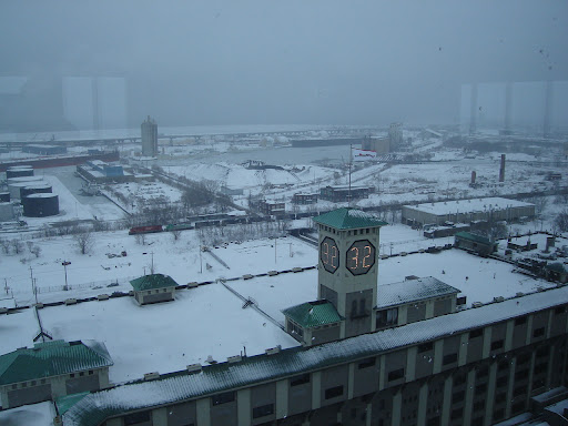


NWS Chicago Snow Reports

Storm Reports for February 5th and 6th Snow Storm


MARITIME NOTES - RIVERDANCE UPDATE

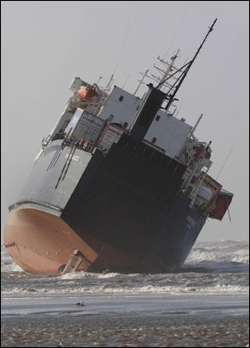
Salvagers work to move the Riverdance ferry


People who enter the exclusion zone around the stricken Riverdance ferry risk a fine or arrest, police said.

The ship, which is listing at about 50 degrees, has turned into a tourist attraction since running aground on Blackpool beach on Thursday.

HM Coastguard said onlookers straying too close during the salvage operation were putting themselves in danger.

Lancashire Police said they would step in to help the private security firm maintaining the 400m exclusion zone.

The Riverdance had been heading from Warrenpoint, County Down, to Heysham, Lancashire, last week when it was hit by a freak wave.

Twenty-three people were lifted to safety, including 19 crew and four passengers.


The area remains dangerous and unstable so people must remain cautious
Insp Tim Newton, Lancashire Police

A salvage team is still working to refloat the vessel, which is carrying almost 1,200 tonnes of freight in lorry trailers and containers.

Concerns have been raised after sightseers were seen posing for photographs next to the angled ferry.

"They're walking out along the sand at low water," a coastguard spokesman said.

A spokesman for Seatruck Ferries, which owns the ship, said the ship moved in high tide on Monday, causing about six containers to fall off.

Lancashire Police are providing assistance to the salvage operation and are warning the public to stay clear and use a section of the promenade set aside for people to watch from a safe distance.

Salvage continues

Insp Tim Newton, of Lancashire Constabulary, said: "We've had huge numbers of visitors over the last week to see the spectacle.

"We have been working closely with the Maritime and Coastguard Agency to facilitate the salvage operation and prevent people going onto the sand and out to the vessel.

"The area remains dangerous and unstable so people must remain cautious."

Anyone found in breach of the cordon will be asked to move on and if this request is refused, police say they could be issued with a fine.

If a person refuses to give details they will risk being arrested, the force said.

Salvage equipment is being lifted by crane on to the Riverdance in a bid to pump water into the empty ballast tanks to reduce the list.

The operation is likely to continue into Thursday when the prospects of refloating the vessel will be reviewed, said a spokesman for Seatruck Ferries.

Nautical Archaeology Workshop April 2008

The workshop teaches divers why underwater archaeology is important, how they can impact and protect Ohio's wrecks, techniques they will use during shipwreck surveys and much, much more.

For those in peril . . .
Remember the seafarers around the world


From
February 5, 2008

Sir, The recent bad weather affecting several ships off our coastline (report, Feb 4) has brought into sharp relief the extraordinary situations the seafarers who crew the merchant fleet face in order to keep us in the manner to which we have become accustomed.

The media have praised those involved in the dramatic rescue of the crew and passengers of the Horncliff (off the coast of Scilly) and the Riverdance (near Blackpool). However, no mention has been made of the crews that daily face heavy seas.

There are currently more than 1.2 million seafarers around the world manning the merchant fleet. The UK relies on shipping for more than 90 per cent of its daily needs. Seafarers bring us our food, our clothes, our petrol and our cars. We need them and they need us. Yet, because they are only in port for a few short hours, coupled with the long hours they work and the isolation they can feel while in a port miles from the nearest town, we push them to the backs of our minds.

As news breaks of possibly more foul weather to come, I urge all readers to remember the significant contribution seafarers make to the life of this country and to each and every one of us.

The Rev Canon Bill Christianson
Secretary General

The Mission to Seafarers


RS

Saturday, February 2, 2008

M/F Riverdance, The Horncliff and NWS Chicago Updates

The RoRo ferry Riverdance, which went aground on Thursday night on the foreshore at Blackpool, shifted slightly with the last high tide and has moved further up the beach.

Passengers and non essential crew were airlifted from the vessel last night, by rescue helicopters from Royal Navy, RAF and Irish Coastguard and 14 people including four passengers were winched off. Nine crew members, who had remained on board to ballast the vessel for improved stability whilst aground, were evacuated this morning.

All crew members have been taken to a hotel, pending arrangements for repatriation. The majority of crew members are Polish.

SOSREP, Secretary of States Representative for Salvage has been in discussion with salvors, but no final plans for refloating have been made. There is no reported oil pollution from the vessel, which is in a stable condition.

There is no change in the situation of the fishing vessel Spinning Dale, which went onto rocks this morning at Village Bay, St Kilda.

Stornoway Coastguard coordinated the rescue of the 14 Spanish crew members after they were unable to evacuate to a life raft due to the severe weather conditions, with Force 9 winds.

The Spinning Dales’ crew members were airlifted off the vessel by Coastguard Rescue Helicopter 100 from Stornoway flown by Liz Forsythe. This was the first time that a woman pilot had carried out an air evacuation from a ship in UK waters. The operation was a difficult one, due to very high winds gusting up to 50 knots above the cliffs.


Rescue mission for seriously injured sea captain


Horncliff

A rescue mission to airlift a seriously injured captain off a ship damaged by force 10 storms has been called.

An RAF helicopter battled force nine winds in a bid to airlift the skipper, who has serious spinal injuries and internal bleeding.

Falmouth Coastguard have said the skipper of the Horn Cliff has serious spinal injuries and internal bleeding

There are reportedly six other passengers on board who are suffering from lesser injuries.

The cargo ship, called the Horncliff, is carrying bananas and other fruit from the Caribbean and was caught in the storm off the Isles of Scilly en route to Dover.

The coastguard has said the vessel has also lost around 90 containers and is listing slightly but there is no danger of it sinking.

The Irish Coast Guard was assisting in the rescue operation and had hoped to take seven people off the vessel, including the captain.

Weather forecaster, Daniel Adamson, said conditions in the Irish Sea are improving significantly.

He said: It's still a windy evening but it's much calmer than it was last night and earlier on today. Conditions have improved a lot.

"There will be more rain tomorrow and it will be a windy weekend, but it will be nothing like as bad as it has been."

© Independent Television News Limited 2008. All rights reserved.


CHICAGO WEATHER UPDATE!

January 31-February 1 2008 Snow Storm (
NWS REPORT)

A winter storm that developed in the southern plains and tracked northward from the Gulf coast into southern Indiana left a swath of snow of around 4 to 8 inches across north central Illinois and 7 to 12 inches across northeast Illinois and northwest Indiana. Light to moderate snow started up late Thursday morning that dropped about an inch to an inch and a half by Thursday afternoon.

Moderate snow, that was heavy at times, started up later in the afternoon Thursday and lasted through the morning on Friday. Some lingering snow lasted through the early afternoon in northwest Indiana that dropped an extra inch or so of snow. Here is a map showing where the heaviest snow fell, along with reports from COOP observers, official NWS observations, CoCoRaHS reports, and public reports. The National Weather Service in Romeoville would like to thank all of our great observers across our area for their reports yesterday and today and everyday!


RS

Friday, January 4, 2008

Winter in Romania!

Heavy snow blankets Romania and Bulgaria


SOFIA, Bulgaria -- A bitterly cold winter storm gripped parts of Europe on Thursday, leaving at least three sailors dead in the sinking of a ship and thousands stranded at airports, on snowy mountain roads and in remote villages.

In northeastern Bulgaria, authorities declared a state of emergency, with the army called in to help civil defense authorities clear roads and reach stranded motorists.

A cold spell also caused problems in neighboring Romania, where Bucharest's two main airports were closed. Parts of Turkey and Greece, as well as Western Europe, were also affected. Some 311 Bulgarian villages were left without electricity and dozens were cut off without food supplies or fresh water, authorities said. The northern Danube municipality of Ruse declared a state of emergency after snow blocked many roads, said Andrei Ivanov, chief of the Balkan country's civil defense service.

Temperatures fell to minus 15 degrees Celsius (5 Fahrenheit), while snow drifts reached two meters (more than six feet) in parts of the country. Hundreds of motorists were trapped on mountain roads.

At least three crewmen were killed when a Bulgarian ship carrying scrap metal sank early Thursday during a storm on the Azov Sea between Ukraine and Russia, officials said.

The Vanessa was carrying a crew of 10 and a Ukrainian pilot who was guiding the ship as it approached the Kerch Strait, which connects the Azov Sea to the Black Sea, said Sergei Petrov, a spokesman for the Emergency Situations Ministry for southern Russia.

Petrov said rescuers pulled one survivor and three bodies from the sea, where waves were as high as 10 feet. In Romania, thousands of passengers were stranded Thursday after Bucharest's two main airports were closed due to heavy snowfall. The snow also blocked many roads in the south of the country, forcing the closure of at least one border crossing with Bulgaria and prompting train delays.

In Turkey's capital, Ankara, snowfall caused traffic jams and accidents, but no injuries were reported. Temperatures in Greece fell to a low of minus 18 degrees Celsius (minus 1 Fahrenheit) in the north of the country, where snow blanketed roads.

In Western Europe, ice and snow disrupted traffic. The Mont-Blanc tunnel linking France and Italy was closed to trucks until Friday because sharp temperature differences between the two sides threatened to disrupt the tunnel's ventilation, traffic authorities announced.

A Boeing 737 from Marrakech, Morocco, flown by the Atlas Blue airline, slid off an icy runway while landing Thursday morning, said authorities at the airport in Deauville, northern France. The plane came to a halt in grass. The 169 passengers were evacuated unharmed.

Cold weather and heavy snow disrupted traffic in Sweden and caused half a dozen road accidents Thursday.

Fourteen people received minor injuries and one was wounded seriously after two buses collided in icy conditions in central Sweden.

In southern Sweden, two passenger ferries traveling from Rostock in Germany to Trelleborg were kept waiting at sea for several hours Thursday morning, as the bad weather made it impossible to dock. The situation was resolved in the early afternoon.


MARITIME NOTES

From Holland & Knight


USCG – Rescue 21 update

The US Coast Guard issued a press release stating that, on January 9, it will formally accept the new Rescue 21 facility at Sector New York on Staten Island. Rescue 21 is an advanced radiocommunications system that offers direction-finding capability, reduction in coverage gaps, enhanced playback capability, digital archiving of calls, and increased channel monitoring capability. (1/3/08).

NOAA – ensuring accuracy of Global Navigation Satellite System

The National Oceanic and Atmospheric Administration (NOAA) issued a news release stating that it will lead an international effort to ensure the accuracy of the Global Navigation Satellite System by pinpointing the locations of more than 40 global positioning satellites in Earth orbit. (1/3/08).

UK – container ship refloated

The UK Maritime and Coastguard Agency (MCA) issued a press notice stating that the container ship that grounded on Varne Bank in Dover Strait has, with the aid of three tugs, been refloated. The ship is undergoing inspection in a safe anchorage. (1/2/08).


RS

Thursday, January 3, 2008

It ain't just snow!


Here are the totals for the New Years Eve/Day Snow Storm across the area from the NWS Chicago Office.

New Years Eve/Day Snowfall

Storm total snowfall from December 31st through January 1st…


Location

Total


St. Charles (7NW)
7.9"


Barrington

7.1"


St. Charles

7.0"


St. Anne

6.8"


Herscher

6.7"


Wauconda

6.5"


Elgin


6.4"


Batavia


6.3"


Dekalb


6.2"


Bourbonnais

6.2"


Chatsworth

6.0"


Elgin


5.7"


Streamwood

5.7"


Oak Brook

5.4"


Paw Paw

5.3"


Harvard


5.0"


Watseka

5.0"


LaGrange

4.8"


Beecher

4.8"


Chicago Botanic Gardens
4.7"


Northbrook

4.6"


Rockford (offical)

4.5"


Steward

4.5"


Chicago OHare (official)
4.4"


Mundelein

4.4"


Lisle


4.0"


Midway (3SW)

4.0"


Ottawa (3SW)

4.0"


Joliet East

3.9"


Yorkville


3.8"


Milford


3.8"


Woodstock (5NW)
3.7"


LaGrange

3.6"


Downers Grove

3.6"


Roscoe


3.5"


Joliet (2N)

3.3"


NWS Romeoville

3.0"


Dwight


3.0"


Coal City

3.0"


Beach Park

2.9"


Peru


2.6"


Rochelle

2.5"


Schaumburg

2.5"


Channahon

2.5"


Mendota

2.4"


Gibson City

2.3"


Joliet Lock and Dam
2.0"


Paxton


2.0"


South Beloit

1.7"


Dixon (East-Side)
1.3"


Willowbrook

1.3"


Indiana


Chesterton

11.3"


Valparaiso (5NNE)
10.2"


Lake Village

9.8"


Demotte

8.1"


Morroco

8.0"


Lowell


6.8"


Valparaiso (3SE)

5.6"


Schererville

5.1"


Wanatah

5.0"


So you think its just snow and flurries in Florida! Try the rest of the world!

CURRENT ACTIVE STORMS IN THE WORLD


South Indian Ocean
-----------------------

Area of Responsibility
=================================
BOM - Perth (90E-130E, South of 10S)
BOM - Northern Territory (130E-140E, South of 10S)
TCWC Jakarta, Indonesia (90E-130E, North of 10S)


Bureau of Meteorology - Perth

(1) Central South Indian Ocean

Tropical Cyclone Outlook (03Jan)
==================================
Ex-Tropical Cyclone Melanie was located near 22.8S 106.4E as of 10 am WDT. The low is not expected to redevelop into a tropical cyclone.

There are no other significant lows evident in the central southeastern Indian Ocean at this time.

(2) Southeast Indian Ocean

Tropical Cyclone Outlook (03Jan)
=================================
Tropical Cyclone Warning Center Darwin is currently issuing advices for a developing tropical low near 14S 128E. Although the low is expected to develop further it is not expected to move into the western australia region.

Another tropical low (weak) is currently near 17S 116E and is moving northeast. The low is expected to weaken further and not develop into a tropical cyclone.

Joint Typhoon Warning Center

Tropical Disturbance Summary (1800z 02Jan)
============================================
The area of convection (92S) near 16.4S 114.2E or 350 NM north of Learmouth, Australia. Recent microwave and enhanced infrared imagery indicates a loosely organized low level circulation center with the main burst of convection to the west of the low level circulation center. Upper level support is limited due to moderate shear values and interaction of the remnant of Melanie.

Maximum sustained winds near the center is 15-20 knots with a minimum sea level pressure of 998 mb. Due to high vertical wind shear values, the potential of this disturbance to form into a significate tropical cyclone within the next 24 hours is POOR.

Bureau of Meteorology - Northern Territory

TROPICAL LOW
14.3S 127.9E - 30 knots 990 hPa

Tropical Cyclone Advice/Warning #2
=================================

At 6:00 AM UTC, Tropical Low [993 hPa] located near 14.1S 128.0E or 155 kms north of Wyndham and 365 west-southwest of Darwin had 10 minute sustained winds of 30 knots with gusts up to 45 knots. The low is reported moving west at 6 knots.

The low is expected to become slow moving, and possibly develop into a TROPICAL CYCLONE tonight or tomorrow morning, before moving eastward toward the Top End of the Northern Territory.

GALES could affect coastal and island communities between Mitchell Plateau in Western Australia and Daly River Mouth in the Northern Territory overnight or early tomorrow morning.

If the system were to take a more northeast track, there is the possibility that GALES could affect coastal and island communities between Daly River Mouth and Goulburn Island, including Darwin and the Tiwi Islands late on Friday or on
Saturday.

Heavy rain is expected to cause flooding in the north Kimberley region from tomorrow.

Heavy rain is expected to cause flooding in the north Kimberley region from tomorrow.

Tropical Cyclone Watches/Warning
===============================

A Cyclone WARNING is current for coastal and island communities from Mitchell Plateau in Western Australia to Daly River Mouth in the Northern Territory.

A Cyclone WATCH is current for coastal and island communities from Daly River Mouth to Goulburn Island, including Darwin and the Tiwi Islands


Storm archives (Active Storms in Bold)

December/January
04U.Melanie - 966 hPa
05U.NONAME - 994 hPa

06U.NONAME - 990 hPa
-----------------------
South Pacific Ocean
------------------------

Area of Responsibility
=============================
RSMC Nadi - Fiji Meteorological Services (E of 160E)
Bureau of Meteorology - Brisbane (W of 160E/S of 10S)
TCWC - Port Moresby (W of 160/N of 10S)
TCWC Wellington - New Zealand (E of 160E/S of 25S)

RSMC Nadi

No Current Tropical Bulletins/Advisories

Brisbane Bureau of Meteorology - Queensland

Tropical Cyclone Outlook (02January)
===============================
The low pressure system located over the central Coral Sea is not expected to develop into a tropical cyclone. It is still producing strong to gale force winds over a broad area east of southern Queensland and over coastal waters south of about St. Lawrence.

----------------------
Southwestern Indian Ocean
-----------------------

Area of Responsibility
=================================
RSMC Metro France - La Reunion

DEPRESSION TROPICALE, EX-ELNUS
22.5ºS 40.8ºE - 30 knots 998 hPa

Tropical Cyclone Warning #15
=============================================
At 6:00 AM UTC, Tropical Depression, Ex-Elnus [998 hPa] located near 22.5S 40.8E or 1495 kms west of the coast of Reunion had 10 minute sustained winds of 30 knots with gusts up to 45 knots. The storm is reported moving south-southeast at 7 knots.

Dvorak Intensity: T2.0/2.5

Near Gale-Force Winds within 30 NM from the center extending up to 90 NM in the southwestern quadrant and up to 140 NM in the southeastern quadrant, and locally reaching 35kts in the southeastern semi-circle up to 30 nm from the center.

Strong gusts under squalls.

Forecast and Intensity
======================
24 HRS: 24.0S 41.0E 35 knots (Tempête Tropicale Moderée)
48 HRS: 24.9S 41.4E 30 knots (Depression Tropicale)

Additional Information
========================
The low level circulation center is partially exposed northwest of the deep convection due to a rather strong northwestly vertical wind shear. Elnus should track southward for the next 36 hours and take advantage of a decreasing wind shear to slightly re-intensify to moderate tropical storm stage. Beyond located between two upper level ridges, the first shifting eastward and the other rebuilding in the west, the system should track southeastwards.

Joint Typhoon Warning Center

Tropical Cyclone Warning #6
============================
At 0:00 AM UTC, Tropical Cyclone Nine (Elnus) had 1 minute sustained winds of 30 knots with gusts of 40 knots. The cyclone was located 390 NM west-southwest of Antananarivo, Madagascar moving south-southeast at 4 knots.

Significant wave height associated with 09S Elnus is 17 feet.

Storm archives (Active Storms in Bold)

December/January

06R.ELNUS - 994 hpa

MARTIME NOTES

The Internatio
nal Maritime Human Element Bulletin, Issue 1

The PDF version of issue 16 of the Alert! Bulletin is now available for download from: http://www.he-alert.org/documents/bulletin/Alert!_16.pdf

You can also view a Flash version at: http://publishing.yudu.com/A5lhu/AlertIssue16

Issue 16 of Alert! focuses on complacency and routinisation. It introduces the term Rogue Behaviour to describe some of the character traits that can bring about a culture of non-compliance, lapses of judgment and unprofessional behaviour.

Included are articles from accident investigators, academics and a ship master offering some thoughts on how to overcome some of these traits.

Some rogue behaviour inducing conditions are readily recognisable: boredom, complacency, drudgery, familiarity, ignorance, impulsiveness, risk taking and routinisation. Others may not be so easy to recognise: apathy, assumptions, compliance, contentment, contempt, dumbing-down, invulnerability, perceptions, predictability and seclusion – all of these are explored further in the centrespread feature of this bulletin.

Through the Alert! Project, we seek to represent the views of all sectors of the maritime industry – contributions for the Bulletin, letters to the editor and articles and papers for the website database are always welcome.


And we welcome your comments on this report!

RS