 Remote Operated Vehicles (ROVs) have had a great impact on the maritime community. Lets take a look a another type of ROV.
Jason/Medea(ROV)
Jason/Medea is a remotely operated vehicle (ROV) system designed by the Woods Hole oceanographic Institution’s Deep Submergence Laboratory for scientific investigation of the deep ocean and seafloor. It is a two-body ROV system, with Medea serving in a tether management role that decouples Jason from surface motion.
Together they offer wide area survey capabilities with Jason as a precision multi-sensory imaging and sampling platform. Both Medea and Jason are designed to operate to a maximum depth of 6,500 meters (21,385 feet), are transportable, and can be operated from a variety of vessels.

Medea, shown on deck, serves as a buffer between Jason and the ship. Image courtesy of Woods Hole Oceanographic Institution.
Jason is connected to Medea by a neutrally buoyant tether that is 0.84" in diameter and approximately 35 meters long. Like the tow cable, it also uses three copper conductors and three single-mode optical fibers, but uses Spectra fibers to provide strength while reducing size and weight. The tether has a breaking strength of 41,000 lb. Medea weighs 1200 pounds in air and is maneuvered by controlling the surface ship’s position within a dynamic positioning reference frame.
Movements of the support ship maneuver Medea utilizing dynamic positioning. Jason is propelled by six DC brushless electric thrusters that provide about 600 pounds thrust in the vertical, longitudinal and lateral directions. The vehicle has excellent passive stability in pitch and roll. Jason is designed for detailed survey and sampling tasks that require a high degree of maneuverability. It weighs about 8,000 pounds in air but is neutrally buoyant at depth. Jason’s closed loop controlled dynamic positioning abilities make it a very maneuverable and stable platform.
Both Medea and Jason have been designed to be superior real time optical imaging platforms with high quality cameras and lighting. The vehicles work together to provide lighting for each other in a fashion not commonly available in other submersible systems. Medea is configured with a silicon intensified target (SIT) black & white camera for terrain identification and visual location of Jason when both are operating.

Jason's sample tray. Click image for larger view and image credit.
Jason's sample tray can be configured in a variety of arrangements to accomplish the Scientist's objectives. Typically, Jason will carry water samplers, push cores to collect seafloor cores (mud!), a "slurp" pump to collect critters, a temperature probe to record the ultra hot temps of water coming out of the hydrothermal vents. Many researchers wish to collect rocks which Jason collects with its manipulators. Up to 310 lbs of samples can be stored on Jason's tray and brought back to the surface.
Once Jason is in the water, it takes 3 people to operate it - a Pilot who "flies" the ROV, an Engineer who monitors all the systems (electrical, mechanical, hydraulic, etc) and operates the winch which pays out / hauls in the fiber optic cable which is attached to Medea and a Navigator who positions the research vessel so that Medea and Jason can operate in the desired area. Because the vehicles are capable of operating 24 hours per day, 3 shifts of people are required to run it. Therefore, 9 people go to sea with Jason - plus a 10th person who is responsible for organizing all the data which is collected! The first Jason ROV began its career in 1988 and retired in 2001. During that time, Jason made 253 dives with 4683 hours on the bottom! The longest dive the first Jason made lasted 117 hours. The new ROV Jason has been in operation since 2002. So far, 183 dives have been made with 3249 hours on the bottom.The Web team gratefully acknowledges this contribution by Woods Hole Oceanographic Institution, Woods Hole, MA.
Weather Story
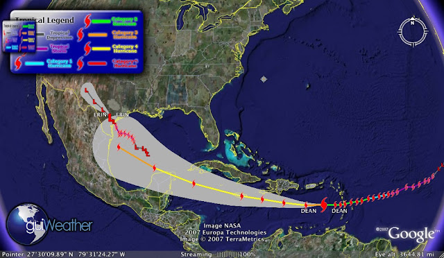
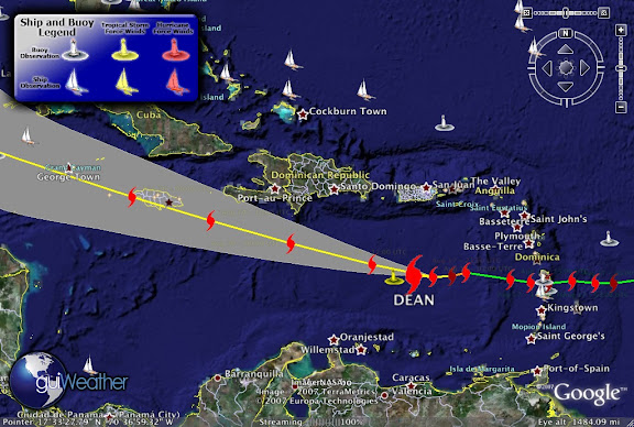
The Latest on Ingrid...
|

000
ABNT20 KNHC 170230
TWOAT
TROPICAL WEATHER OUTLOOK
NWS TPC/NATIONAL HURRICANE CENTER MIAMI FL
1030 PM EDT SUN SEP 16 2007

FOR THE NORTH ATLANTIC...CARIBBEAN SEA AND THE GULF OF MEXICO...

THE NATIONAL HURRICANE CENTER IS ISSUING ADVISORIES ON TROPICAL
DEPRESSION INGRID...CENTERED ABOUT 160 MILES EAST OF THE LEEWARD
ISLANDS.

1. SHOWER ACTIVITY HAS DECREASED THIS EVENING OVER THE CENTRAL
CARIBBEAN SEA IN ASSOCIATION WITH A TROPICAL WAVE AND AN UPPER-LEVEL
TROUGH.  UPPER-LEVEL WINDS ARE CURRENTLY UNFAVORABLE FOR
DEVELOPMENT OF THIS SYSTEM...BUT THEY COULD BECOME A LITTLE MORE
FAVORABLE FOR SLOW DEVELOPMENT OVER THE WESTERN CARIBBEAN IN A
COUPLE OF DAYS AS THE SYSTEM MOVES WESTWARD AT 10 TO 15 MPH.

2. A TROPICAL WAVE LOCATED ABOUT HALFWAY BETWEEN AFRICA AND THE LESSER
ANTILLES IS PRODUCING A LARGE BUT DISORGANIZED AREA OF CLOUDINESS
AND THUNDERSTORMS.  DEVELOPMENT OF THIS SYSTEM...IF ANY...IS
EXPECTED TO BE SLOW TO OCCUR IT MOVES WESTWARD AT 10 TO 15 MPH.

ELSEWHERE...TROPICAL CYCLONE FORMATION IS NOT EXPECTED DURING THE
NEXT 48 HOURS.

$

FORECASTER KNABB

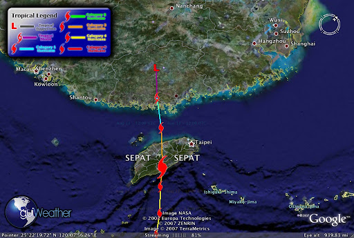
 Update on Typhoon NARI

Summary
At the last observation, on 2007/09/16 12:00 UTC, tropical cyclone NARI is a Tropical Storm with maximum sustained wind speeds of 30 m/s (111 km/h, 60 knots). Within 100km of its eye there are 5.6 million people. Within 200km there are 22.3 million people.
The storm is affecting the provinces Cholla-bukto in South Korea (less than 1000 people), Cholla-namdo in South Korea (less than 1000 people), Ch'ungch'ong-namdo in South Korea (2 million people), Kyongsang-bukto in South Korea (2.8 million people), Kyongsang-namdo in South Korea (3.6 million people), Kwangju-jikhalsi in South Korea (1.1 million people). The closest 6 cities are Suncheon, Samcheongpo, Yeosu, Jeonju, Gimje, Jinju.
New Typhoon - Typhoon 13W (Wipha)

Update on the F/V Papa GeorgeWe have spoken to the United States Coast Guard Marine Causality Investigations Division Portland. Unfortunately the make and model number of the EPIRB in question was lost with the vessel. Though the EPIRB was inspected and certified for some reason when the vessel went down the EPIRB did not release. The f/v Papa George sank in deep water and there is no contemplation of salvage currently.
We are continuing to seek information about the EPIRB through other sources.
Maritime Note:
New Flame to be split in two as part of the salvage operation |
| The New Flame off the southern most point of Gibraltar - Photo EFE |
After the separating he said that stern would remain afloat, and could be towed to a safer location in the bay. Then the 27,000 tons of scrap metal it contains would be removed. The bow of the boat is at a depth of 23 metres underwater and will be salvaged in sections.
He said work to salvage the vessel would start in three weeks and take four to six months to complete, depending on the weather, and that there was no risk of pollution in this second phase of the operation.
So far the Greek salvage company, Tsavliris, have removed 780 tons of fuel from the ship’s tanks.
Caruana thanked the Spanish Government and the European Agency for their offers of help, but noted Gibraltar had taken less time than Spain to remove the fuel from the vessel, when compared to the 'Sierra Nava' case.

Have a great week!
RS

























![[Valid RSS]](valid-rss.png "Validate my RSS feed")