Ok so what is the Theta-E and why is it used?
Meteorologist Jeff Haby explains.
1. What is THETA-E?
THETA-E (Equivalent Potential Temperature) is the temperature that results after all latent heat is released in a parcel of air and the then brought adiabatically to the 1000 mb level. THETA-E increases as dewpoint
2. How is THETA-E determined?
First determine the pressure level of interest. Locate the temperature and dewpoint at that pressure level. Raise that parcel adiabatically from that pressure level to the 200-mb level. Next, bring the parcel down dry adiabatically to the 1000 mb level. The temperature once the parcel is at 1000 mb is the THETA-E.
3. Operational significance of THETA-E:
INSTABILITY- A region with a relatively high THETA-E is often the region with the most instability. Warmer low level temperatures and higher low level dewpoints increase instability.
LOW LEVEL JET- A low level jet from a moisture source will often bring in higher THETA-E values and thus increased instability.
THETA-E RIDGE- These are regions with higher THETA-E. They are often the burst point for convective activity.
4. Pitfalls:
a. If a strong cap is in place, convective storms will not occur even if THETA-E is high.
What does this mean to Storm Chasers? Storm Chaser Steve Sponsler explains...
Have you ever wondered where a true frontal boundary or the dry-line exists? Why ask?
When it comes to chasing...you have to know these factors along with many others...but this discussion is focused only on Theta-E for discussions sake:
The Theta-E advection parameter could be a major clue. It combines what surface analysis provides as well as the dewpoint forecast parameter.
It also works in tandem with injecting dry slots...and what I often think of as "pressure points". One must combine these two to "brew" the secret ingredient.
VISUALIZE...and work it...Dry Slots swiping up moisture and being forced to rotate because of the earth's rotation..in reality..it makes perfect sense.
And for chasing purposes...PLAN your road networks in advance.
I surmise that anyone here already does that.
It COULD be a "secret" ingredient to what might overlie all the other parameters provide. But then again...I please hope than no one denies that luck in all cases is involved in a successful chase."
CASE STUDY-1
A relationship between a surface theta-e ridge and dominant lightning polarity
Nettie R. Lake, Lyndon State College, Lyndonville, VT; and D. R. MacGorman
For many years, it was believed that cloud-to-ground lightning lowered only negative charge to the ground (-CG flashes). In the past twenty years, however, flashes lowering positive charge (+CG flashes) have been documented and studied. This presentation summarizes positive correlations between +CG flashes, hail, and tornadoes.
Recent studies have reported that in some cases, dominant storm polarity reverses from positive to negative. Additionally, it has been observed that 50% of such storms are tornadic, and that tornadoes usually occur during or after the reversal. Smith et al. (2000) observed that polarity reversals often occur at surface equivalent potential temperature (theta-e) ridges. This study examined dominant polarity patterns of severe storms during the entire year 1999. Similar to Smith et al. (2000), this study found that 82% of polarity reversals occur at a theta-e ridge.
Furthermore, positively dominated storms that move parallel to a ridge axis seldom reverse polarity. Also, negative storms do not reverse polarity relative to a theta-e ridge. Explanations for why polarity reversals may occur at a theta-e ridge will also be discussed.
CASE STUDY - 2WMSI - A New Index For Forecasting Wet Microburst Severity
Kenneth L. Pryor and Gary P. Ellrod
Office of Research and Applications (NOAA/NESDIS)
Camp Springs, MD
Date Submitted: November 20, 2003
Abstract
A new index to assess the potential and severity of wet microbursts is currently under development. The index, designated as the Wet Microburst Severity Index (WMSI), accounts for the physical processes of convective storm development and downburst generation by incorporating such parameters as convective available potential energy (CAPE), to represent the process of updraft formation, and Theta-e Deficit (TeD), to represent downburst development.
Since convective storm updrafts require buoyant energy, a very important parameter used in the analysis of convection is CAPE, which is easily computed from Geostationary Operational Environmental Satellite (GOES) sounding data. Since updraft strength is proportional to CAPE, large CAPE would result in strong updrafts that could lift the precipitation core within a convective storm to the mid-level dry air layer. CAPE also plays a major role in the formation of precipitation.
The strong updrafts resulting from large CAPE will increase the size of precipitation particles, which, in turn, will then enhance the effect of precipitation loading. The amount of mid-level water vapor relative to the low-level water vapor in the atmosphere as indicated by a sounding profile is important in the determination of the strength of downdrafts that occur in convective storms. This condition is modeled by the Theta-e Deficit (TeD), represented by the algorithm TeD = theta-emax - theta-emin, where (theta-emax) refers to the maximum value of theta-e at the surface and (theta-emin) refers to the minimum value of theta-e in the mid-levels of the troposphere.
TeD serves as an important indicator of the difference in water vapor concentration (plus thermal energy cpT) between the surface and mid-levels. Large TeD values imply the presence of relatively dry air at mid levels that will result in evaporative cooling and the generation of large negative buoyancy as the dry air is entrained into the convection cell. The WMSI algorithm is given as the following expression: WMSI = (CAPE)(theta-emax - theta-emin)/1000.
CASR STUDY - 3Midlevel Dry Intrusions as a Factor in Tornado Outbreaks Associated with Landfalling Tropical Cyclones from the Atlantic and Gulf of Mexico.
Lon Curtis
KWTX-TV, Waco, Texas
ABSTRACT
Midlevel dry intrusions have been mentioned as a factor in tornado outbreaks associated with landfalling tropical cyclones for more than three decades, but a systematic analysis of historical outbreak cases with respect to this pattern has been missing.
Herein, following an examination of all named tropical cyclone landfalls from the Atlantic and Gulf of Mexico for the period 1960–99, 13 “outbreak” cases (defined as storms producing 20 or more tornadoes) have been identified with 11 of the cases offering clear evidence of a dry intrusion at midlevels over the outbreak area. The outbreaks all occurred when the favored area for tornadogenesis (the right-front or northeast quadrant of the storm) coincided with a pronounced gradient of relative humidity, with the gradient best reflected at the 700- and/or 500-hPa level(s).
Two distinct patterns were identified with respect to the origin of the midlevel dry air involved in these cases: in one, a mass of dry air that impinged on much of the northern or northwestern semicircle of the storm's outer circulation gradually divided into two separate areas (one to the northwest and the other to the northeast of the storm center) as the storm advanced; the other involved ingestion of a lobe of dry air from a reservoir most often located in the eastern semicircle of the storm.
The outbreak cases were determined to have a strong diurnal signal detected in the temporal distribution of the tornadoes, as almost two-thirds (65%) of the tornadoes in the 11 “positive” cases occurred between 1500 and 2400 UTC (daylight hours in the region examined). A review of all tropical cyclone landfall events since 1960 revealed that there are only three cases with clear evidence of a midlevel dry intrusion that were not accompanied by an outbreak as defined herein.
TORNADO OUTBREAK
30 Twisters in Al, Ga and Fla for 17 February 2008
Meteorologists Study Deadly Tornado Outbreak
Warm moist air and a shifting weather pattern courtesy of the La Nina phenomenon aided in the development of the Feb. 5 tornadoes, which killed at least 50 people and were among the 15th deadliest in U.S. recorded history. But meteorologists are now trying to explain why the tornadoes occurred so early in the year.
It was farther north than most February tornadoes and stronger, Joseph Schaefer, director of the Storm Prediction Center in Norman, Okla., told Associated Press.
Tornadoes do occur in February. In 1971, a deadlier February outbreak in the Mississippi Delta killed 121 people. A study conducted by Schaefer two years ago, found that winter tornadoes in parts of the South occur more frequently and are stronger when there is a La Nina, a cooling of Pacific waters that is the flip side of the better known El Nino.
February tornadoes usually pop up near the Gulf Coast, not in Kentucky or Tennessee, said University of Oklahoma meteorology professor Howard Bluestein.
A heavy contributing factor was the warm weather. It was 84 degrees in Oklahoma before the storm front moved through on its path of destruction. On Tuesday, 97 weather stations broke or tied records in Arkansas, Alabama, Tennessee and Kentucky - the hardest-hit states, according to Associated Press.
Still, meteorologists said there is not enough recorded historical evidence of such storms to blame global warming at this point, but Tuesday’s tornadoes had all of the key deadly elements: warm air near the ground; high winds; and warm moist air coming north from the Gulf of Mexico.
Schaefer told Associated Press, La Nina doesn’t specifically cause tornadoes, it helps shift the jet stream, pushing storms from the West and moisture from the Gulf into the necessary collision course over the South. El Nino, La Nina occurs every few years, and has been changing global weather patterns for a few months now, Mike Halpert, deputy director of the Climate Prediction Center, which monitors La Nina, told Associated Press.
Preliminary figures for January show 136 tornadoes, five tornado deaths and three killer tornadoes, although these figures tend to drop after closer analysis.
Between 1997 and 2007, the average February has 30 tornadoes, killing 9 people. Early reports tallied 68 tornadoes so far this month. "We're off to a big start for the year," said Greg Carbin, a meteorologist at the storm center. Meteorologists said that the patterns point to the likelihood of more tornado outbreaks this season. "As long as the pattern remains the same it can be very active," Schaefer said. "It's not a time to let down your guard."
MARITIME NOTES:
Shell Oil to put sensors on Gulf rigs to gauge storm strength, share data with forecasters
Maya Bell
Sentinel Staff Writer
February 14, 2008
Exactly how and why that happens may become a bit clearer one day, thanks to new undersea sensors Shell Oil Co. has agreed to install on one of its oil platforms in the Gulf south of New Orleans.
Known as "thermistors," the instruments will measure heat content of the water to a depth of 100 meters, or about 330 feet, and may be operable by this fall, in time for the peak of the 2008 hurricane season. The data could help hurricane scientists measure the effects of warmer water on storm intensity.
They are one piece of a nearly $1 million investment the oil company is making to collect data for hurricane research, forecasting and coastal-resource management.
Marking the first private-public partnership of its kind, Shell has agreed to acquire and install weather and oceanic data-collecting sensors on seven of its oil and gas facilities in deep waters off the Gulf Coast from
The
"This is very significant," said
Under federal law, 59 deep-water gas and oil platforms operating in the Gulf already are required to collect and transmit observations of ocean currents to NOAA's National Data Buoy Center. But the agreement between NOAA and Shell, forged after NOAA administrator Conrad Lautenbacher and Shell President John Hofmeister met at a 2006 summit on the Gulf and discussed how their organizations could leverage their strengths, goes much further.
In addition to the ocean heat sensors, by next spring Shell will install transmitters, complete with battery-backup power, on four platforms that will send sea-surface and air temperatures, pressure and wind speed to NOAA's geostationary satellites -- even if the platforms are evacuated because of a hurricane. Tethered to the sea bottom by cables, the platforms can twist in a figure eight to withstand storm-force currents and winds.
Shell also has agreed to collect and share meteorological data from two Continental Shelf locations off
Because
"Think about it: More than half of Florida's real estate is on the Gulf of Mexico," said hurricane-center spokesman Dennis Feltgen. "And storms don't always move west. Sometimes they come from the west. Remember Wilma," a reference to the 2005 late-season storm that swept across southwest
While Shell spokeswoman Darci Sinclair said the thermal sensors should help hurricane forecasters improve on their weakest skill -- predicting the intensity of storms -- forecasters said the data will likely be of more use to researchers. But they'll be glad to have it.
"Every meteorologist always wants every bit of data he or she can get," hurricane specialist James Franklin said.
Maya Bell can be reached at mayabell@orlandosentinel.com or 305-810-5003.
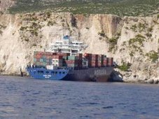
GROUNDED cargo ship, the Riverdance, is expected to set sail this week - and it couldn't come quick enough for local residents.
Locals living in the English holiday town of Blackpool have experienced the same tourism fever Newcastle locals had when the Pasha Bulker ran aground last year.
Blackpool's promenade has become a "nightmare" with locals complaining of traffic jams as people across England travel to see the Riverdance, an Irish-owned ship which has been grounded for 17 days.
"When it first happened it took me 45 minutes to get down the road to get home. The parking is a nightmare too," Blackpool local Steven Wilkinson said.
"It'll be worse this week with half term holidays. You can't blame people for coming to see the ferry though. It's a one off and their kids want to see it."
It's not only the locals who are complaining. Sightseers say they are finding it difficult to park in the small seaside town.
"I've come every day to see the ferry. It's jolly good to see so many people here. But there are a lot of cars. People living here know where to go for parking spaces, but visitors wouldn't know where to park. There aren't enough spaces," visitor Clarice Dale told the Blackpool Gazette.
Small business owners will be sad to see the Riverdance go.
"Our business has doubled. The longer it's here, the better it is for us. It's been great for business, you don't need to advertise the area - just put a boat on the beach! " Ann Wilkinson, owner of Blackpool's The Eating House said.
RS



![Validate my RSS feed [Valid RSS]](valid-rss.png)
No comments:
Post a Comment