By Brian K. Sullivan
Sept. 11 (Bloomberg) -- Hurricane Ike tripled in size in the central Gulf of Mexico on a weekend collision course with the 5.6 million residents of the Houston area.
Traffic jammed highways as Texas coastal communities evacuated.
The system's strongest winds extend as far as 115 miles (185 kilometers) from the eye, up from 35 miles yesterday, the Miami- based National Hurricane Center said today. Ike's wind field is now larger than that of Katrina, the storm that devastated New Orleans in 2005, said Jeff Masters, the director of meteorology at private forecaster Weather Underground Inc.
``The total amount of energy is more powerful than Katrina, so we could be seeing a storm surge that could rival Katrina,'' Masters said. The storm is so large ``the location doesn't matter much; it is going to inundate a huge part of the Texas coast.''
Three houses away from Galveston Bay in LaPorte, Jamie and April Ybarra packed their two children, two dogs and cat into a Chevy sports utility vehicle and prepared to leave.
``I think the call for evacuation came a little late,'' Jamie Ybarra, a 32-year-old safety coordinator, said. ``You hear the roads are crowded; you hear people are losing their cool.''
This is the third time the family has evacuated in three years, April Ybarra said. And ``we may not be coming back here for awhile.''
Galveston, parts of southern Houston and areas south of the city and near the Texas coast were under a mandatory evacuation order that started at noon today. Hurricane Ike is following a track similar to the 1900 Galveston hurricane that killed 8,000 people, the deadliest storm in U.S. history.
Felt Before Landfall
Ike was a Category 2 hurricane with sustained winds of 100 mph, up from 80 mph yesterday, the center said in an advisory at 4 p.m. Houston time. Its central pressure is more like that associated with a Category 3 or 4 storm, Masters said.
``It is a massive storm; it is impacting in terms of its scope 40 percent of the Gulf,'' said Michael Chertoff, U.S. secretary of Homeland Security, in a conference call from Washington. ``The most important message I can send is, do not take this storm lightly. This is not a storm to gamble with. It is large and powerful and carries a lot of water with it.''
The storm is 400 miles east-southeast of Galveston and moving west-northwest at 10 mph, with landfall south of Galveston forecast for early Sept. 13. Because of its size, Ike will be felt along the Texas coast long before its eye makes landfall.
Strengthening Likely
The center's forecasters said Ike may strengthen to at least a major hurricane with Category 3 intensity, meaning sustained winds of at least 111 mph, before landfall. Other forecasters predict Ike may become a Category 4 storm, the second-strongest on the five-step Saffir-Simpson scale, packing winds from 131 to 155 mph.
The storm is forecast to sweep through the center of the Gulf, missing the offshore Louisiana oil and natural gas fields. The Gulf is home to about a quarter of U.S. oil production.
Even so, about 96 percent of all oil production in the Gulf has been shut in along with 73.1 percent of natural gas facilities, according to the Minerals Management Service, a bureau of the Interior Department. Some facilities have been closed since Hurricane Gustav struck Louisiana last week.
Exxon Mobil Corp.'s Baytown facility, 17 miles east of Houston, is the country's biggest, with a capacity of 586,000 barrels a day. The Louisiana Offshore Oil Port, which is the largest U.S. oil-import terminal and handles 13 percent of imports, said it closed marine operations because of Ike.
Chemical Plants Closed
Dow Chemical Co., the largest U.S. chemical maker, and competitors such as DuPont Co., LyondellBassell Industries and Texas Petrochemicals Inc. are closing plants in the Houston area. The Texas Gulf Coast produces two-thirds of the nation's ethylene, used in products from plastic bags to auto parts.
President George W. Bush declared an emergency for Texas, his home state, and Governor Rick Perry readied 1,350 buses to evacuate residents in preparation for Ike's landfall. As many as 7,500 Texas National Guard members are on standby.
Houston's population is 2.2 million, making it the fourth- biggest U.S. city, according to the U.S. Census Bureau, and its metropolitan area, with a population of 5.6 million, is the sixth-largest in the U.S.
Officials in Harris, Brazoria, Chambers, Matagorda and Galveston counties ordered about 564,063 people to leave homes that are now in Ike's path. Television news reports showed miles- long traffic jams in the area.
Governor Urges Prudence
``My message to Texans in the projected impact area is this: finish your preparations because Ike is dangerous and he's on his way,'' Perry said in a statement. ``If your local officials tell you to evacuate, follow their instructions.''
Jim Rouiller, a meteorologist with Planalytics Inc. in Wayne, Pennsylvania, said he's particularly worried about storm surge damage around Galveston Bay, on the coast southeast of Houston, which may be in the top right quadrant of the storm field where rains and winds are most powerful.
Galveston's seawall is 17 feet high and the forecast storm surge is 20 feet high.
``If that's breached, a whole refinery complex goes under water,'' Rouiller said.
Some parts of the Texas-Louisiana coast may get as much as 15 inches of rain, the hurricane center said.
Ike could inflict between $5 billion and $15 billion of insured damage depending on how much it intensifies, said Steve Smith, atmospheric physicist for the Carvill reinsurance broker.
NASA Center Closed
NASA's Johnson Space Center heeded the evacuation order, preparing to shut its 1,600-acre facility in Houston that houses Mission Control and the training ground for astronauts.
In July, Hurricane Dolly, with winds of 100 mph, struck the Texas coast at South Padre Island, about 35 miles northeast of Brownsville.
Crude oil for October delivery fell $1.68, or 1.6 percent, to $100.90 a barrel at the 2:30 p.m. close of floor trading on the New York Mercantile Exchange. Futures touched $100.10, the lowest since April 2. Prices are up 31 percent from a year ago.
Morphed Integrated Microwave Imagery at CIMSS (MIMIC)
IKE TRACK
|
WEATHER NOTE
NOAA Historical Hurricane Tracks Web Site Helps Users Prepare for Big Storms
As the U.S. coastal population continues to grow, so do the hazards when big storms approach. Now, an on-line tool, Historical Hurricane Tracks, helps users get a quick picture of coastal areas with the greatest frequency of hurricanes and tropical storms�and that historical "snapshot" can help community members and local emergency managers develop better plans for storm preparation and recovery.
NOAA's Historical Hurricane Tracks Web site, http://maps.csc.noaa.gov/hurricanes/, includes data on storm strikes through 2007. Current hurricane activity can be followed at http://www.nhc.noaa.gov.
"When you know the history of hurricane landfalls in your community, you are better prepared to protect yourself from these potentially devastating storms," says Margaret Davidson, director of the NOAA Coastal Services Center. "Historical Hurricane Tracks is part of a suite of products developed by the center to help coastal residents, planners, and emergency managers prepare for�and reduce�the affects of coastal storms."
The website allows users to generate customized maps showing the path of storms that have made landfall in the United States in years past. Users can search by U.S. ZIP code, state or county, latitude and longitude, or a storm's name or year. Searches can be narrowed to specific storm categories.
Developed by NOAA's Coastal Services Center in partnership with NOAA's National Hurricane Center, the site contains more than 150 years of Atlantic hurricane data and nearly 60 years of eastern north Pacific Ocean data, which may be downloaded for use in geographic information system applications. The site also links to detailed reports on the life history and effects of U.S. tropical cyclones since 1958.
NOAA understands and predicts changes in the Earth's environment, from the depths of the ocean to the surface of the sun, and conserves and manages our coastal and marine resources. Visit www.noaa.gov.
On the Web:
NOAA Coastal Services Center: http://www.csc.noaa.gov
NOAA National Hurricane Center: http://www.nhc.noaa.gov
During the afternoon hours of Thursday September 4, the remnants of what was once Hurricane Gustav continued to move northeast passing over far southern Lake Michigan during the evening hours on September 4th. Several bands of rain moved through northeast Illinois and northwest Indiana with one band eventually producing small areas of convective cells that moved through northern Jasper County Indiana.
One of these convective cells produced a tornado approximately 5 miles northwest of Wheatfield, IN near the Oak Heritage Estates. This torando caused structural damage to one mobile home, damage to multiple trees and corn fields. The damage track began southwest of the Heritage Estates near the intersection of north 450 West and Hawthorn Rd. where a 10 yard diameter wide area of corn stalks were completely flattened in a convergent manner. Damage continued northeast from there where a roof was lifted off a mobile home and thrown into the yard. Also at this residence were two large trees that were completely uprooted. These were two or four trees that were uprooted by this tornado, with many trees having branches from their tops sheared off. Also, there was other debris scattered about, including kids toys and trach bins.
The tornado was on the ground for approximately 1/4 mile wth a maximum path width of 20 yards. The maximum winds with this tornado were estimated to be around 90 mph, which is consistent with EF-1 damage on the Enhanced Fujita scale.
Tornado Location
MARITIME NOTE
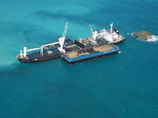
Crew error blamed for grounded ship
A report has blamed crew error and management principles for the grounding of a bulk carrier in Gladstone Harbour, off central Queensland, last year.
The Endeavour River ran aground at the entrance to Auckland Channel on December 7 last year while trying to berth at South Trees Wharf on a flood tide.
The master of the ship was battling a tail wind and even with the use of two attending tugs, was unable to counteract the tidal influence.
Five days later, the ship was eventually refloated and manoeuvred to the wharf by tugs.
The Australian Transport Safety Bureau report has stated bridge resource management principles were not practised by the bridge team and that no monitoring of the passage took place.
The report has also identified a number of safety issues which are being addressed by ASP Ship Management and Maritime Safety Queensland.
STAY SAFE
RS









![Validate my RSS feed [Valid RSS]](valid-rss.png)
2 comments:
Great post.
Ike really has become massive. Hope everyone stays safe in Texas. We are having a bad enough time off the Alabama coast.
Velu
Velu
Looking back at your post.... Massive was an understatement..... Besides pounding Texas. Ike dumped 25.7" of rain though out the Midwest. Now that was indeed massive.....
Thanks fro writing.....
Post a Comment