The Earth’s jet streams, the high-altitude bands of fast winds that strongly influence the paths of storms and other weather systems, are shifting—possibly in response to global warming. Scientists at the Carnegie Institution determined that over a 23-year span from 1979 to 2001 the jet streams in both hemispheres have risen in altitude and shifted toward the poles. The jet stream in the northern hemisphere has also weakened. These changes fit the predictions of global warming models and have implications for the frequency and intensity of future storms, including hurricanes.
Christina Archer and Ken Caldeira, of the Carnegie Institution's Department of Global Ecology at Stanford, tracked changes in the average position and strength of jet streams using records compiled by the European Centre for Medium-Range Weather Forecasts, the National Centers for Environmental Protection, and the National Center for Atmospheric Research. The data included outputs from weather prediction models, conventional observations from weather balloons and surface instruments, and remote observations from satellites. The results are published in the April 18 Geophysical Research Letters.
Jet streams twist and turn in a wide swath that changes from day to day. The poleward shift in their average location discovered by the researchers is small, about 19 kilometers (12 miles) per decade in the northern hemisphere, but if the trend continues the impact could be significant. “The jet streams are the driving factor for weather in half of the globe,” says Archer. “So, as you can imagine, changes in the jets have the potential to affect large populations and major climate systems.”
Storm paths in North America are likely to shift northward as a result of the jet stream changes. Hurricanes, whose development tends to be inhibited by jet streams, may become more powerful and more frequent as the jet streams move away from the sub-tropical zones where hurricanes are born.
The observed changes are consistent with numerous other signals of global warming found in previous studies, such as the widening of the tropical belt, the cooling of the stratosphere, and the poleward shift of storm tracks. This is the first study to use observation-based datasets to examine trends in all the jet stream parameters, however.
“At this point we can’t say for sure that this is the result of global warming, but I think it is,” says Caldeira. “I would bet that the trend in the jet streams’ positions will continue. It is something I’d put my money on.”
WEATHER NOTE
Heed this advice to stay safe during storms
Storm safety advice
Thunderstorms
So, what should you do when a thunderstorm is approaching? The National Weather Service provides the following advice:
•If you are already indoors, stay indoors. If you're outside and can get to your house or another sturdy shelter, do so quickly. Once indoors, unplug appliances, because utility lines and metal pipes can conduct electricity. Don't take a shower, and use the phone only in an emergency.
•If you can't get indoors, the hard exterior of an automobile will provide some shelter from a thunderstorm. A convertible is not a safe shelter during a storm.
•If you can't get either indoors or to a car, look for a low and open space, away from trees, poles and fences. If you feel your skin tingle or your hair stand on end, a lightning strike is imminent, and you should make yourself as small as possible by crouching on the balls of your feet and wrapping your arms over your head.
•If you're in the woods, seek shelter under low trees or brush. If you're swimming or in a boat, get out of the water as quickly as possible and seek a safe shelter. If you're caught on the golf course, stay away from your clubs, cart, water or lone trees. If there are no shelters, find a low-lying area and stay there.
•In the event that you're in your car during a thunderstorm, stay there, but don't touch any metal parts. Pull over in the event of hard rain or excessive wind and never drive through standing water if you can't tell how deep it is. If you are in your car in the area of a flash flood, the best option is to leave your car and search for higher ground.
Six inches of water can cause loss of control and stalling in most passenger cars. A foot of water will make most cars float, and two feet of rushing water can sweep away a vehicle, even a sport utility vehicle.
Tornadoes
If you are under a tornado warning, the National Weather Service recommends that you follow this advice:
•Move to a basement or other low area that is away from windows. If you are in a mobile home and a tornado is predicted, try to find a sturdier shelter. Mobile homes are notoriously poor shelters from tornadoes.
•If you don't have a basement, crouch down in an interior hallway or small room on the lowest level. Stay away from windows.
•If you're outside and can't find shelter with a tornado approaching, seek a low-lying area, such as a ditch or depression. If you're on a golf course, a sand trap is a good option for shelter. Lie flat and wrap your arms around your head. Don't however, lie in ditch that's against a fence or wall, as the structure could blow over and crush you.
•If you're in your car and a tornado is approaching, do not try to outrun it. Get out of your car and seek a low-lying area that is away from the vehicle. Never take shelter under an overpass, because winds can intensify within them.
Flash floods
Flash floods result when storms drop a large amount of water very quickly.
They can occur with very little warning, and can be extremely dangerous because water moves very quickly. If you see water rising, move immediately to a higher place. Never let children play in an area prone to flooding if there is the possibility of a storm.
Hailstorms
In the event of a hailstorm, stay inside and do not try and protect your house. Close your blinds to help prevent glass from breaking into your house if a window is struck by a large piece of hail. Stay away from skylights, windows and doors.
If you're caught in a hailstorm and can not get indoors, seek shelter under brush or small trees, but stay away from tall objects, as hail is usually accompanied by lightning.
Don't take chances.
If the weather is fair, many of us will be outside today. We'll enjoy the company of friends and family, perhaps watch a parade with a child, grill some hamburgers or light up a sparkler to celebrate the holiday.
While we revel in spending long days outside at this time of year, it's important to maintain awareness of the potential for danger from summer storms, particularly those that occur with little warning.
Many people fear major storm events, such as hurricanes, and take significant steps to prepare for them. Readiness in the event of an approaching storm is key to surviving the storm and minimizing damage, according to experts. And, because hurricanes occur over a period of time, they can be tracked and their paths predicted, giving those in their paths time to take the necessary precautions.
Thunderstorms and tornadoes, however, are more challenging to prepare for because they're often unpredictable and catch people off guard.
"The larger the storm, the easier it is to predict," said John Frye, a meteorologist who will join the geography department at Kutztown University for the fall term as an assistant professor. "Hurricanes last days to weeks, but thunderstorms can last only a few hours, and tornadoes only minutes. That makes it difficult to say where they'll occur. We're good at predicting that they will occur, but it's difficult to say exactly where."
According to the National Weather Service, an average of 100,000 thunderstorms occur throughout the United States every year, along with 5,000 floods and 1,000 tornadoes. Potential dangers of those storms, of course, include lightning, hail, high winds and dangerous waters.
Lightning is a major concern in thunderstorms, Frye said, and everyone, including children, should be aware of its potential danger.
"There's definitely a possibility that you could be hurt or suffer fatal injury," Frye said.
Pennsylvania ranks third among the 50 states in the most combined deaths and injuries caused by lightning, according to the National Weather Service. Only Florida and Michigan had more lightning-related deaths and injuries.
And, Frye said, a thunderstorm doesn't have to be right on top of you before lightning becomes a threat.
"If you can hear thunder, you're in the danger range of being struck by lightning," he said.
Frye cited the National Weather Service's "30-30 Rule," which advises people to get inside when there is 30 seconds between a lightning flash and the following clap of thunder, and not go back outside until 30 minutes after the last clap of thunder.
"That's good advice," Frye said. "You don't want to take chances in a thunderstorm."
The National Weather Service issues watches and warnings for severe thunderstorms and tornadoes. A watch, explained Frye, is when atmospheric conditions are favorable for storms of these types and the area in which they're likely to occur has been identified. A warning, he said, is when a storm has been identified by trained spotters or radar, and is in progress.
When lightning, or other danger, strikes
By Wallace McKelvey
Staff Writer
BETHANY BEACH -- From microscopic bacteria to 60-year-old artillery, a variety of hidden dangers await beachgoers along the Delaware and Maryland coastline.
Joan Furlong, of Washington, D.C., said she is vaguely aware of the dangers present at the beach.
"I've seen Jaws and I wear sunscreen," she said. "But there are other things you don't think about."
In 2007, Bethany Beach Patrol conducted 498 rescues, the majority of which occurred in August, and the Rehoboth Beach Patrol answered 880 assistance calls, ranging from splinters to spinal cord injuries.This year, the Ocean City Beach Patrol recorded more than 2,000 rescues in a six-day period while Hurricane Bertha spun offshore.
Despite the fears of most swimmers, Capt. Butch Arbin of the Ocean City Beach Patrol said sharks pose little danger.
Sick or injured sea turtles, seals and porpoises arrive with much greater frequency, he said.
"In those cases, we have to protect the sea life from people," Arbin said.
Non-predatory animals that feel threatened by humans, he said, are more likely to attack.
"Seals look cute on TV, but they're dangerous," Arbin said. "A seal could bite your finger off."
According to the International Shark Attack File, there have been no unprovoked shark attacks in Maryland since records began in 1678.
In Delaware, three shark attacks have been recorded with no fatalities. The last incident Delaware Seashore State Park nature center manager Jim Hall can recall anecdotally occurred in 1964.
Tick bites and bacterial infections are the more common biological threats.
"You don't want to go wading around belly-deep in Rehoboth Bay in August and not bathe for a couple days," he said.
Hall said vibrio vulnificus, a bacteria present in warm salt or brackish water, can cause lesions on the skin from exposure through cuts or scrapes.
"But it's so easily prevented by rinsing off with fresh water," he said.
Ticks and chiggers are especially prevalent this summer in wooded and grassy areas of the park, Hall said. The best way to avoid these pests, which may carry Lyme disease, is to remain on marked trails.
Although animal life may instill anxiety in beachgoers, he said many dangers are man-made.
"The most dangerous thing you'll encounter at the beach is some other human," Hall said.
Two years ago, he said a fisherman reeled in a surf-fishing rig with a piece of human scalp attached.
"It appeared that someone reared back to cast their line out and hooked someone's hair," Hall said. "It went out into the ocean, the line broke and it floated off."
Beachcombers have also stepped on fishing hooks, he said.
"You think maybe it's a crab biting your toe," Hall said. "And find a No. 2 tailhook stuck in the bottom of your foot."
Particularly in the bay, where wave action is minimal, he cautions visitors about glass washing ashore.
"You could've broken a bottle 50 years ago and it's every bit as sharp now as it was then," he said.
Capt. Kent Buckson of the Rehoboth Beach Patrol advises visitors to wear sandals or shoes although glass bottles are prohibited on the beach.
"Every day we see cut feet or splinters from walking barefoot on the boardwalk," he said.
Heat is another hazard for beachgoers, Buckson said. He recommends visitors stay hydrated and eat breakfast and lunch.
"People pass out from being lightheaded and overexerting themselves out here in the heat," he said.
Many shipwrecks have occurred in the bay, including one buried beneath the sand of Rehoboth Beach, but Buckson said it poses no risk to visitors.
Bill Winkler, owner of Treasure Quest in Ocean View, said WWII-era shrapnel and live artillery are a persistent problem due to recent beach replenishment projects.
"A kid came into the store the other day," he said. "Without a metal detector, he'd picked up 200 pieces (of shrapnel) in front of Sea Colony (in Bethany Beach)."
The hazardous material was dredged up with sand from the ocean floor, Winkler said. Screens picked up larger material and live artillery, but the smaller pieces were dispersed, buried and left on the beach.
Arbin said Ocean City has one or two instances of live artillery found every year, frequently after heavy storms.
"If we see something come up, we move people back, maintain a perimeter and bring in the bomb squad who will remove and dispose of it," he said.
On windy days, Arbin said beach umbrellas can become deadly projectiles.
"If they roll down the beach, they'll roll end over end doing pole vaults," he said. "If someone's laying where the pole hits, they could be killed or seriously injured."
Arbin said the proper way to erect an umbrella is to tilt it into the wind, since a strong gust will only force it further into the sand.
Digging large sand holes can also pose a danger.
Several years ago, Arbin said a 4-year-old nearly died when a sand hole dug by her father collapsed around her.
"Each time you breathe, sand fills in and you can't get a deeper breath," he said.
Hall said trucks have become stuck in sand holes dug by children oblivious to the danger.
"The kids are trying to dig to China," he said. "Then they don't fill in the holes."
Arbin said one of the worst threats to beachgoers is lightning from sudden thunderstorms.
"The most dangerous place to be is an open space," he said. "And that's the beach."
During his 35 years on the Ocean City Beach Patrol, Arbin said there has been 10 lightning strikes, five of them fatal.
Arbin said swimmers and sunbathers should leave the beach as soon as lifeguards send out the warning because lightning can strike before the appearance of stormclouds.
"People shouldn't question us," he said. "They'll hesitate, say they'll only take a second, but it only takes a millisecond for lightning to strike."
MARITIME NOTEOwner Working To Free Stuck Freighter
Ship Ran Aground In Government Cut
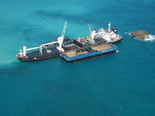
MIAMI -- A cargo freighter that ran aground en route to the Port of Miami Wednesday afternoon will not be moved before Thursday.The owner of the 279.8-foot freighter named the Island Intrepid is contacting a salvage company to try to free the boat. The freighter lost its steering and ran aground at Government Cut, according to the United States Coast Guard.The ship is not impacting traffic in or out of the port.The Coast Guard is closely monitoring the situation.
Deaths in Tuzla
ESER KKAŞ, Star
Work accidents in shipyards are more frequent than other sectors. In order to calculate the risk of accidents, a comparison is needed between the figures in Turkish shipyards sector and that of developed countries. If Turkey is doing poorly, which is definitely the case, necessary measures should be taken promptly.
Labor unions should calculate and publish injury and death statistics as well as the investigation process and sentencing periods of over 100 previous accidents.On Monday, three ship workers drowned while being used as “sand bags” in a shipyard. This is not an accident. This is murder. To use human as “sand bags” is ferocity; it is primitiveness.
All the responsible parties should be tried for murder. It is impossible to name this incident as a work accident. Big newspapers should keep this issue in headlines for a month to prevent new murders.
What is moral turpitude? Is it nude pictures we see on TV or in magazines, or is it using shipwrights as “sand bags”?
From Holland and KnightUSAF – meeting re PNT architecture for GPS
The US Air Force issued a notice stating that it will host a Positioning, Navigation, and Timing (PNT) Architecture Industry Day in Savannah on September 16 to discuss architecture transition planning related to the Global Positioning System (GPS). 73 Fed. Reg. 47593 (August 14, 2008).
The US Coast Guard National Maritime Center (NMC) released the latest edition of its occasional newsletter – The Wave. This edition addresses, among other things, the steps necessary to obtain a merchant mariner document and the transition of Regional Examination Centers (RECs) to NMC field units. (8/12/08).
HAVE A GREAT WEEKEND!
RS


![Validate my RSS feed [Valid RSS]](valid-rss.png)
No comments:
Post a Comment