Saturday, June 9, 2007

Bevent, WI Tornado Aftermath, June 7th 2007


Bevent, Wisconsin Tornado and its destruction near Hwy 153 and CTY J around 5pm on June 7th, 2007. (Footage Courtesy of Matt Kaskavitch and Matt Westlund)

While Chicago escaped the worst from a line of thunder storms, Thursday evening 7 June 2007, the Northern Suburbs took most of the punch. Rain totals varied from Villa at 1.38" to Grayslake at 3.60". Most of the damage was downed trees, power lines and flash floods.

Wisconsin was entirely a different story, Where five tornado's touched down. At Bear Paw in Langslade County, Wisconsin, the resort was struck by a tornado rated by NWS as a EF3 with winds estimated between 140 to 165 MPH. It lost 10 buildings with damage estimated at some $200,000.00. As of Friday AM NOAA reported a total of 292 reports of severe weather across the region. There were some minor injuries but no deaths reported in any of the Wisconsin storm reports.

Below is the summary from WCM Chicago Jim Allsopp of the storm damage in the Chicago area.

000
NWUS53 KLOT 081740
LSRLOT

PRELIMINARY LOCAL STORM REPORT...CORRECTED
NATIONAL WEATHER SERVICE CHICAGO/ROMEOVILLE IL
1240 PM CDT FRI JUN 08 2007

..TIME... ...EVENT... ...CITY LOCATION... ...LAT.LON...
..DATE... ....MAG.... ..COUNTY LOCATION..ST.. ...SOURCE....
..REMARKS..

0700 PM NON-TSTM WND DMG CHICAGO 41.88N 87.63W
06/07/2007 COOK IL DEPT OF HIGHWAYS

CHICAGO DEPT OF STREETS AND SANITATION REPORTED 884 TREES
DOWN OR DAMAGED...71 TRAFFIC SIGNALS OUT...45 LIGHT POLES
DAMAGED...76 DOWNED WIRES TO LIGHT POLES AND LIGHTS.
OFFICIAL WIND GUSTS TO 45 MPH ATMIDWAY...OHARE...WAUKEGAN
AND VALPARAISO. GUST TO 48 MPH AT ROMEOVILLE.

0955 PM TSTM WND DMG DIXON 41.85N 89.48W
06/07/2007 LEE IL EMERGENCY MNGR

TREE LIMBS AND POWER LINES DOWN.

1005 PM TSTM WND GST MOUNT MORRIS 42.05N 89.43W
06/07/2007 E60.00 MPH OGLE IL FIRE DEPT/RESCUE

TREE LIMBS DOWN.

1020 PM TSTM WND DMG BYRON 42.13N 89.26W
06/07/2007 OGLE IL DEPT OF HIGHWAYS

6 INCH TREE LIMBS DOWN.

1100 PM TSTM WND DMG DIXON 41.85N 89.48W
06/07/2007 LEE IL DEPT OF HIGHWAYS

TREES AND LIMBS DOWN.

1140 PM TSTM WND DMG KIRKLAND 42.09N 88.85W
06/07/2007 DE KALB IL DEPT OF HIGHWAYS

TREE LIMBS BLOWN DOWN IN NORTHWEST PART OF DEKALB COUNTY.


1156 PM TSTM WND GST WAUKEGAN 42.37N 87.87W
06/07/2007 M52.00 MPH LAKE IL OFFICIAL NWS OBS

WAUKEGAN AIRPORT.

1200 AM TSTM WND DMG CRYSTAL LAKE 42.23N 88.33W
06/08/2007 MCHENRY IL LAW ENFORCEMENT

TREE LIMBS DOWN. ESTIMATED 60 MPH WIND FROM SPOTTER.

1200 AM HAIL CRYSTAL LAKE 42.23N 88.33W
06/08/2007 M0.75 INCH MCHENRY IL TRAINED SPOTTER

1214 AM TSTM WND DMG WAUCONDA 42.27N 88.14W
06/08/2007 LAKE IL NEWSPAPER

LARGE TREE DOWN.

1216 AM TSTM WND DMG GRAYSLAKE 42.35N 88.04W
06/08/2007 LAKE IL NEWSPAPER

LARGE TREE FELL ON A HOUSE.

1218 AM TSTM WND DMG ROUND LAKE 42.35N 88.11W
06/08/2007 LAKE IL NEWSPAPER

ROOF TORN OFF LUMBERYARD.

1255 AM FLOOD 1 W BEACH PARK 42.42N 87.88W
06/08/2007 LAKE IL CO-OP OBSERVER

2.00 INCHES OF RAIN SO FAR WITH 1.46 IN PAST 60 MINUTES.

0100 AM TSTM WND GST WAUKEGAN 42.37N 87.87W
06/08/2007 M62.00 MPH LAKE IL OFFICIAL NWS OBS

WAUKEGAN HARBOR.

0207 AM FLOOD MCHENRY 42.34N 88.29W
06/08/2007 MCHENRY IL TRAINED SPOTTER

2.5 INCHES OF RAIN FROM 10 PM TO 2AM CDT.

0529 AM FLASH FLOOD 2 WNW ZION 42.47N 87.88W
06/08/2007 LAKE IL LAW ENFORCEMENT

ILLINOIS ROUTE 173 AND DELANY ROAD ARE CLOSED DUE TO
LOCAL FLOODING

0702 AM FLASH FLOOD 3 W ZION 42.46N 87.90W
06/08/2007 LAKE IL LAW ENFORCEMENT

THE WATER OVER ILLINOIS ROUTE 173 AND KILBOURNE IS SLOWLY
RECEDING


&&

$$

ALLSOPP

RS

Friday, June 8, 2007

Another Plane Of View


As I have mentioned before, many times we view things on one plane of thought as we see them, without considering or imagining another view point. For example, the two video's (lower bottom on left) of ship's encountering heavy sea's. It is one thing to try and understand what it looks and feels like from the ships point of view or from the air looking down. Its another thing to see it from shore side.

This video is of a passenger ferry departing its port in New Zealand. This vessel is approximately 600 feet long. Watch the waves effects on this vessel and how the ship interacts with the waves from a shore-based point of view.

Consider now, the mechanical stress factors that these waves are placing on this ship and the emotional stress on the crew and passengers.
I can tell you that it took a strong Master and Crew to pilot this vessel under these conditions. Of course the passengers, I am sure had one heck of a ride.

Now imagine a 44 foot sail boat encountering these waves!


On the weather front in the Northern Illinois region last night;

Chicago got spared from much of the T-Storm damage last night.Though wind gusts, three miles offshore were reported at 60+ MPH and downtoen at 53MPH. But north and west of the city did not fair so well. There were reports of a tornado, funnel clouds, hail, downed electrical wires, downed trees and flash floods stretching from Lake, DeKalb, Ogle, McHenry, Winnebago and Cook Counties in Illinois. However, Wisconsin took a beating. In Langlade, WI the Bear Paw Inn was hit by a tornado and was totally devastated. There are no reported injuries or deaths with all accounted for.

Today the probability for widespread hazardous weather is low.

RS

Thursday, June 7, 2007

LATEST INFORMATION - Northern Illinois

LATEST INFORMATION on significant severe weather expected tonight!

A squall line or solid line of thunderstorms is expected to develop over northern Illinois this evening. The greatest severe weather threat from these storms is damaging wind gusts of 60 to 70 mph. These storms will evolve from supercell thunderstorms that will move into northern Illinois from Iowa and Missouri this evening and then race east northeast.

Isolated tornadoes are possible with these storms as well...however the risk of tornadoes will diminsh as these storms come farther east across Illinois and as we get later through the evening.

These storms are being driven by an unusually strong storm system across the northern Plains. This storm system is winter-like in terms of its wind energy...with winds over 100 mph in the upper levels of the atmosphere. This wind energy combined with abundant moisture streaming north ahead of a cold front and high instability prompted by very warm air near the ground and colder air aloft will set the stage for explosive thunderstorms development.

SPECIAL WEATHER ALERT

SPECIAL WEATHER ALERT
Public Information Statement

Statement as of 8:35 am CDT on June 7, 2007

Live severe weather briefings to be held on NOAA weather today...

The National Weather Service in Chicago will be conducting live
severe weather briefings on NOAA Weather Radio today due to the
heightened threat of severe thunderstorms across northern Illinois
and Northwest Indiana tonight.

The first live briefing will take place around 11 am this
morning... with a second live briefing tentatively scheduled to take
place at 4 PM this afternoon. If severe weather develops near near
Illinois earlier than expected then the second severe weather
briefing may be cancelled.


Spotter Activation maybe necessary later tonight in the Northern Illinois region.

The s/v Sean Seamour II & The Hatteras Trench

This chart (my thanks to Jean) represents the last known positon of the s/v Sean Seamour II and what is believed to be the last known position of the s/v Flying Colours. As you will note the s/v Sean Seamour sank and the s/v Flying Colours is missing in what is known as the "Hatteras Trench" a part of the continental margin.

According to NOAA, the continental margin is the underwater portion of a continent that extends from the shoreline to water depths of nearly 5,000 m. Continental margins are typically comprised of three regions: the shelf, slope, and rise. Each region has distinctly different characteristics, because of its distance from shore, water depth, and steepness. In the Atlantic Ocean, continental margins have a shelf that is broad and flat and reaches a depth of 100 m. The slope is the steep transitional area between the shelf and rise, and it lies between depths of 100 and 2,500 m.


The continental margin off Cape Hatteras, North Carolina (at 35° North latitude) displays the typical Atlantic Ocean shelf-slope-rise sequence.
The continental margin off Cape Hatteras, North Carolina, is a classic shelf-slope-rise sequence, while most of the southeast U.S. continental margin is terrace-like, with prominent features such as the Blake Plateau, Blake Ridge, and Blake Escarpment, as well as the Charleston Bump.

Due to the depth of the trench salvage operations, unforunately is almost impossible.


The trench has a well known history for violent seas, especially during storms. The Outer Banks itself is known as the, "Graveyard of the Atlantic". Over the years, some 600 ships have met their faith in this section of the Atlantic. Much of this is due to the fact that the elbow of the Outer Banks of Cape Hatteras, lies in the path of any hurricane and or tropical storm. This elbow acts as a partition or barrier between two oceans ( the North Atlantic and the Gulf Stream), and even a deflector, causing greater storm surges and waves.


Noted ships that have sunk off of Cape Hatteras include the Iron Clad Monitor, the USCGC Bedloe and Jackson, which sank in the Great Altantic Hurricane of 1944. This hurricane wreaked havoc on Hatteras Island actually causing residents to relocate entire villages.

As David Stick writes in his book,
Graveyard of the Atlantic Shipwrecks of the North Carolina Coast. "You can stand on Cape Point at Hatteras on a stormy day and watch two oceans come together in an awesome display of savage fury; for there at the Point the northbound Gulf Stream and the cold currents coming down from the Arctic run head-on into each other, tossing their spumy spray a hundred feet or better into the air and dropping sand and shells and sea life at the point of impact. Thus is formed the dreaded Diamond Shoals, its fang-like shifting sand bars pushing seaward to snare the unwary mariner. Seafaring men call it the Graveyard of the Atlantic."

For example on August 29 1999, along Cape Hatteras, the maxium wave hights caused by Category 2 Hurricane Dennis, as the storm, located approximately 150 miles offshore, battered the Cape Hatteras area for a week, where SWH's (Signifiant Wave Heights) were recorded by the US Army Corp of Engineers as high as 20.5 feet. Although the winds from Hurricane Dennis were not particularly strong, the duration of the effects of the storm on North Carolina's shoreline was remarkable.

Subtropical Storm Andrea had simular effects as she meandered offshore for a few days. But the duration of effects of the storm were felt along the southern coast. Very shortly the National Hurricane Center will be issuing a report of the damages caused by Subtropical Storm Andrea.

We await that report.

On a Illinois weather note;

There is going to be a CoCoRaHS training session held on Tuesday, June 26th at 7pm. The training session will be held at the University of Illinois Extension office in Grayslake. Here is more information about registering, etc on the CoCoRaHS Illinois page:

Tuesday, June 26, 2007 - 7:00 p.m.

University of Illinois Extension Office (Lake County)
100 South US Hwy 45
Grayslake, IL

Register in advance with the University of Illinois Extension-Rockford Center by calling 815-397-7714 or by email at churchj@uiuc.edu. Please register no later than June 22nd.


RS


Tuesday, June 5, 2007

Illinois Gustnado declared Tornado!

The National Weather Service has officially declared the reported Casey, Illinois "Gustnado" as a EF0 Tornado.

The tornado occurred during a chain of Memorial Day Weekend thunder storms. The tornado touched down on 25 May 2007 between the towns of Casey and Martinsville, Illinois. (photo by Curt Coffey).

NWS had received three different photographs of the tornado, along with a detailed account by a chaser who observed the twister for 10 minutes along its 2.5 mile path. The twister was estimated to be on the ground between 14:53hrs and 15:03hrs according to eyewitnesses. This twister was approximately 30 yards wide and stayed in open fields the whole time.

According to NWS, between eyewitness accounts, photos and radar data at the time, showed it was clearly a tornado. NWS said that, it looked like the outflow from a storm to the south was ingested in the parent cell, which increased the strength of the updraft and added aggregation of low level vorticity, which was already present because of synoptic front nearby.

RS

Monday, June 4, 2007

Automatic Triggering of Severe Weather Forecast

NCSA Enables Automatic Triggering of Severe Weather Forecast

The National Center for Supercomputing Applications (NCSA) has developed tools and is providing compute resources to enable atmospheric scientists to automatically produce high-resolution storm forecasts in response to real-world conditions. Hundreds of computer forecasts have been triggered by storm watches and weather discussions over the past several months.

"The idea is that when a critical need exists, we need to provide resources quickly," said Jay Alameda, leader of the middleware development team at NCSA.

The triggered forecasting capability is being rolled out as part of the 2007 Spring Experiment, hosted by the NOAA Hazardous Weather Testbed. The experiment, which runs during the storm-heavy season from mid-April through June, provides forecasters with a first look at the latest atmospheric science research and technology and familiarizes researchers with the needs and challenges of forecasters in the field.

As part of the spring experiment's effort to improve forecasting of severe weather, NCSA has demonstrated the capability to trigger computational simulations in response to real-world conditions. When the NOAA Storm Prediction Center in Norman, Oklahoma, issues a severe thunderstorm or tornado watch, or a discussion of current conditions points to the potential for storms to develop, this information automatically initiates computational forecasts using the WRF forecasting code on one of the compute systems (currently Tungsten or Mercury) that NCSA contributes to the TeraGrid.

"One of the things that's really unique about this is the unpredictability," said Brian Jewett, an atmospheric scientist at the University of Illinois at Urbana-Champaign who is working closely with NCSA on the development of advanced tools and technologies for weather forecasting. Jewett explained that watches can come at any time, and they often come in batches. So multiple simulations can be spawned around the clock.

NCSA's Ensemble Broker software is designed to manage multiple computational jobs. To support the triggered simulation capability, NCSA enhanced the Ensemble Broker so it can submit jobs to the Moab cluster workload management package. The Ensemble Broker also stores numerous aspects of workflow submission and execution, which Jewett said makes it easier for researchers to reproduce the steps they took to get their results and facilitates collaborating with others.

Currently, a single forecast is trigged for each watch or discussion; the forecast is carried out at two resolutions -- one with a grid spacing of 18 kilometers and the other at a high resolution of 2 kilometers. Details on the triggered forecasts are available online at http://rt.atmos.uiuc.edu/trigger/.

Because so many variables affect weather, forecasts are very sensitive to subtle changes in conditions. Atmospheric scientists often use ensemble forecasting to account for these uncertainties, carrying out multiple forecasts with slightly different conditions and configurations. Looking at the results of all of the simulations often provides forecasters with a best estimate for the ensuing weather conditions and gives a measure of the confidence in that forecast. The Ensemble Broker was designed to manage the thousands of jobs required for ensemble forecasting and other parameter studies.

"It's exciting for me to see the capabilities," Jewett said. "It's really general, it's not weather specific, and it's deceptively powerful."

For the spring experiment, all of the triggered simulations are being carried out on NCSA systems, but work has begun toward dynamic job deployment, meaning that once a forecast is submitted the best resource would be identified and the calculations would be carried out on whichever TeraGrid resource could complete the work most quickly. This type of dynamic deployment could be key during a national emergency -- whether it's a hurricane heading for the coast or an infectious disease spreading from person to person.

NCSA's work on tools to support advanced weather modeling and forecasting is supported by the National Science Foundation. NCSA is a partner in LEAD (Linked Environments for Atmospheric Discovery), an NSF-supported effort to create an integrated, scalable framework for identifying, accessing, preparing, predicting, managing, analyzing, and visualizing a broad array of meteorological data and model output independent of format and physical location and in a dynamically adaptive manner.

-----

Source: National Center for Supercomputing Applications

High Sea's & Update On Sean Seamour II


This is the Saga Cruise Line's, Saga Rose. The vessels characteristics include, Gross Tonnage: 24,474 gt. Length: 620 ft. / 189 m. Crew: 350. Full Capacity: 620.

The Saga Rose was built in 1965 for Norwegian American Lines and was later assigned to Cunard and then purchased by Saga Cruises, a subsidiary of Saga Travel. The ship was previously known as the Sagafjord , Gripsholm and Saga Ruby.

On
Nov. 24th, 2006 Sailing from Southampton to Madeir, she hit a storm with 50 + kt. winds for three days and the storm did quite a bite of damage. Let's not also mention the unscheduled and interesting wild ride it's passengers got. Though these waves are not officially reported as freak waves, it will give you an idea what heavy sea states are like. Remember this storm did a lot of damage to the Saga Rose. While your also watching the video (Lower Left Side - Saga Rose - Point and Click ) remember that this is a 620 foot/189 meter ship! Listen to the bridge crew. These are experienced sailors. Now just imagine what a wave such as this could do to a 44 foot sail boat!

I have also added a dramatic video clip of the Cruise Ship Voyager
(Lower Left Side - Voyager - Point and Click )with 776 on board who was enroute between Spain's Balearic Islands to the Italian island of Sardinia and ran into Force 11 Winds (100km/hr) on 2 February 2005 off the coast of France. There was a report of a "giant wave" smashing the bridge window and knocking out electronics. Once again imagine a 44 foot sail boat in these seas!

Running down any known facts in the case of the Sean Seamour II is rather difficult. I again appeal to anyone with any information to contact me here. I have communicated with Dr. Paul C. Liu of NOAA's Great Lakes Environmental Research Laboratory (GLERL) with regards to the Sean Seamour II. The first thing Dr. Liu said was, "thank God they were rescued." Dr. Lui
referring to my email then went on to explain that, "as there is no eyewitness and there is no measurement, it is just not possible to substantiate it one way or the other. The current state of freak/rogue waves research just can not be of any help beyond that." However he goes on to say, "this case clearly occurred during a storm. We know that in general freak/rogue waves can happen during calm or storm conditions."

We know that wave surges can travel thousands of miles in any direction from any storm. Forget the fact that the Sean Seamour II ran into its trouble directly in the middle of a subtropical storm. I am still waiting to see what the National Hurricane Center has to say.

Stay tuned.
RS

Friday, June 1, 2007

Rogue Waves & Latest on the Seamour II


I have been in contact with the National Hurricane Center with regards to the rouge wave theory as I posted yesterday, (The Story of the Sailing Vessel Sean Seamour II). This morning I received a reply. The NHC is assembling a report on the damages caused by Subtropical Storm Andrea which should be forthcoming shortly. The NHC is also taking a look at the rogue wave report and should be back to me in a couple of days.

I have also been in contact with scientists at the Great Lakes Environmental Research Laboratory (GLERL) who are studying rogue and freak waves and I expect to hear back from them shortly as well. The following paper was sent to me by Jamie Rhome of the National Hurricane Center. Its a must read for all mariners.

Maintaining Watch
RS

Expecting the Unexpected Wave: How the National Weather Service Marine Forecasts Compare to Observed Seas

Robbie Berg and Jamie R. Rhome, Tropical Analysis and Forecast Branch, NOAA/Tropical Prediction Center/National Hurricane Center

Introduction

Marine forecasts issued by the National Weather Service (NWS) provide the sea state in terms of the significant wave height (Hs). This value is defined as the average of the highest 1/3 of the waves observed in a wave field. In other words, if a mariner were to observe the passage of 100 individual waves past a given point, the significant wave height would be the average height of the highest 33 waves. The concept of significant wave height was derived during a project to forecast ocean wave heights and wave periods during World War II (Stewart 2005). The Scripps Institute of Oceanography has shown that observed wave heights correspond to the average of the highest 20-40% of the waves, and the significant wave height has evolved to become the highest 1/3 of the waves (Wiegel 1964).

The significant wave height tends to be the height of the waves that is most readily observed by the human eye (WMO 1998). But how does this value compare to the average height of all the observed waves, or the highest wave one might encounter? Unfortunately, misunderstanding of the meaning of significant wave height often leads to improper interpretation of the NWS marine forecasts. Additionally, confusion surrounding the proper measurement of significant wave height leads to subjective and widely varying wave height reports from ships since every mariner would most likely report different wave height values for a given sea state. This is often exacerbated by the fact that observations are dependent on the size of the vessel and the height at which the observation is taken. For example, observations of significant wave heights taken on the main deck of a large ship 80-100 feet above the water often cause the waves to appear smaller than reality. Similarly, a small vessel encountering rough seas may overestimate significant wave height or report only the highest individual waves (WMO 1998). This subjectivity results in vastly different reports of significant wave height from adjacent ships, forcing marine forecasters to speculate as to which report best represents the prevailing sea state. Accurate sea height estimates are critical to the accuracy of the NWS marine program. Accordingly, this paper seeks to provide additional insight into the term significant wave height and its relationship to other wave statistics.

Significant Wave Heights

If a NWS forecast calls for seas 12 to 14 feet, exactly how will the wave field look to a mariner? To better understand what the significant wave height is and what it means to the mariner, we need to turn to statistics and the concept of distributions. Most people are aware of statistical distributions and probably don't even know it. The most common distribution used in real life is the normal, or Gaussian distribution (Figure 1A), which is more commonly referred to as the bell curve because of its shape (Wilks 1995). This distribution is quite good at describing phenomena in which most elements in a group are clustered near an average value with an equal number of elements being greater and less than this average value. Examples include the high temperature in a city for a given day, the weight of babies born at a hospital, or the height of students in a college oceanography class.

Figure 1. Generalized normal  (a) and Rayleigh (b) distributions Figure 1. Generalized normal (a) and  Rayleigh (b) distributions

Figure 1. Generalized normal (a) and Rayleigh (b) distributions.

Wave heights in the ocean are usually modeled according to another statistical distribution called the Rayleigh distribution (Figure 1B). This distribution also has an average value, but in this case most elements are clustered toward lower values, with only a few exceptionally large values. The Rayleigh distribution does not exhibit symmetry like the normal distribution (Wilks 1995).

Several different wave statistics useful to the mariner can be inferred from the Rayleigh distribution. For example, the highest point of the distribution can be thought of as the most frequent wave height observed in the wave field. Roughly speaking, the most frequent wave height Hf is approximately half the value of the significant wave height (see Appendix). Similarly, the average wave height, which will be slightly larger than the most frequent wave, is estimated to be about 5/8 the value of the significant wave height (see Appendix).

Several recent marine incidents have highlighted the importance of knowing the height of the largest wave that can be expected for a given wave forecast. Since the Rayleigh distribution actually goes to infinity to the right of its peak, a wave is theoretically not bounded by a limiting height. This is where the Rayleigh assumption breaks down. Luckily, however, the highest waves can still be estimated through a combination of several methods. For example, it can be shown that 10% of the waves have a height greater than 1.074 times the significant wave height, and the average height of those highest 10% of the waves is approximately 1.272 times the significant wave height (see Appendix). Table 1 shows the relationship between the multiple wave statistics for several common significant wave height forecast values.

Significant Wave Height (Hs) Most Frequent Wave Height (Hf) Average Wave Height ( ) Average of Highest 10% of Waves ( )
4 2 2.5 5
8 4 5 10
10 5 6 13
12 6 7.5 15
15 7.5 9 19
20 10 13 25
Wave conditions at NDBC Buoy 42040 during Hurricane Ivan
52.4 26.1 32.8 66.7

Table 1. Relationship between selected National Weather Service forecast wave heights (significant wave height in feet) and other parameters such as most frequent wave height, average wave height, and average height of the highest 10% of waves (also in feet.) The most frequent wave height, average wave height, and average of the highest 10% of waves at Buoy 42040 during Hurricane Ivan are calculated from the theoretical Rayleigh distribution for the observed significant wave height of 52.4 feet.

In a somewhat tedious process, the above information can be combined with the parameters of the Rayleigh distribution to arrive at a relationship between the significant wave height and the highest expected waves (see Appendix). As an example, assume that the significant wave height in an area is 10 feet. One out of every 100 waves (or 1% of the waves) will have a height greater than about 16 feet. One out of every 1000 waves (or 0.1% of the waves) will have a height greater than about 19 feet. A common rule of thumb often utilized is that the highest expected wave is equal to twice the significant wave height. This kind of height would be observed in about 1 out of every 3000 waves. Incidentally, if an average wave period is known, the frequency of observing the highest expected wave can be obtained by multiplying 3000, or any other number of waves, by the wave period. If the average wave period is 10 seconds, then a wave two times as high as the significant wave height will be observed on average every 30,000 seconds, or about 8.3 hours. In reality, wave height is limited by wave steepness: deep water waves (those in an area where the ocean depth is greater than half the wavelength) begin to break when their height to length ratio exceeds 1/7 (see Appendix).

Here's an example to put all this into context. On September 15, 2004, Hurricane Ivan was racing northward across the Gulf of Mexico towards the Alabama and Florida coastline with strong 115 kts winds that were producing extremely large waves. The Tropical Analysis and Forecast Branch (TAFB) at the Tropical Prediction Center/National Hurricane Center predicted seas (significant wave heights) as high as 55 ft the morning before the hurricane moved into the northern Gulf of Mexico, and this forecast verified quite well with a significant wave height of 52.4 ft reported at NDBC buoy 42040 at 8:00 p.m. as the center of Ivan passed overhead. But not every wave that passed the buoy had a height of 52 feet, so what was the character of the actual wave field during the hurricane?

Figure 2. Rayleigh Wave Distribution for Buoy 42040 - Click to Enlarge

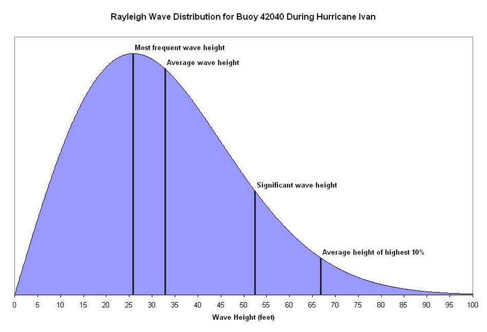
Figure 2. Theoretical Rayleigh distribution of the wave heights at Buoy 42040 at 8:00 p.m. September 15, 2004 as Hurricane Ivan was passing overhead.

A significant wave height of 52 feet seems quite large, but realistically a sizeable portion of the actual waves during the hurricane did not attain that height. The most frequent wave height, according to the Rayleigh distribution, was about 26 feet - still an imposing and dangerous wave for a mariner out at sea. A few waves did build higher than the significant wave height, with the average of the highest 10% of the waves being around 67 feet! Figure 2 shows the theoretical distribution of the wave heights at Buoy 42040 as Hurricane Ivan was passing overhead, and the last row in Table 1 gives the calculated values from the distribution.

There is a limit on the highest wave that would be expected. The average wave period reported by the buoy at the same time as the report of the maximum wave height was about 12 seconds. Therefore, a wave with a 12 second period (which incidentally would have a wavelength of 735 feet), would break when its wave height exceeded 105 feet. Individual waves with shorter periods would break at much shorter wave heights. Based on the rule of thumb for the highest expected wave, a significant wave height of 52 feet could yield a wave of about 104 feet, which lies within the possible range of wave heights given the breaking wave height.

Conclusion

The NWS marine forecasts provided by the Tropical Prediction Center, Ocean Prediction Center, and coastal Weather Forecast Offices convey important wave field information that goes beyond just the expected significant wave height. Other useful wave parameters, such as the most frequent wave and highest expected waves, can be derived that can go into making important decisions regarding safe marine operations. Estimations of the highest expected wave height are especially important in extreme weather events and can be beneficial when trying to avoid large and occasionally devastating storm-generated waves. So, don't be caught off guard by a 26 foot wave the next time the NWS marine forecast reads "SEAS 12 TO 15 FEET"!

References

Stewart, Robert H., 2005: Introduction to Physical Oceanography.
(Available at http://oceanworld.tamu.edu/resources/ocng_textbook/contents.html)

Wiegel, R. L., 1964: Oceanographical Engineering. Prentice Hall, Englewood, NJ.

Wilks, D. S., 1995: Statistical Methods in the Atmospheric Sciences. Academic Press, San Diego, CA, 467 pp.

WMO, 1998: Guide to Wave Analysis and Forecasting. WMO No.-702, Second Edition, 168 pp. (Available from http://www.wmo.ch/index-en.html).

Biography

Robbie Berg has worked as a forecaster in the Tropical Analysis and Forecast Branch of the Tropical Prediction Center/National Hurricane Center since June 2002. He received two B.S. degrees in meteorology and marine sciences from North Carolina State University and is currently pursuing a M.S. degree in meteorology from the University of Miami. Previous work experience includes hurricane research at the NOAA Environmental Technology Laboratory in Boulder, Colorado.

Jamie Rhome has worked as a forecaster in the Tropical Analysis and Forecast Branch of the Tropical Prediction Center/National Hurricane Center since September 1999. He received his B.S. and M.S. degrees in meteorology from North Carolina State University. Previous work experience includes the United States Environmental Protection Agency and the State Climate Office of North Carolina. In addition to his professional experience in marine meteorology, Jamie is an avid offshore fisherman.

Acknowledgments

The authors wish to thank Eric Holweg, Dr. Rick Knabb, Alison Krautkramer, and Daniel Brown for their constructive comments and suggestions on this paper.

Thursday, May 31, 2007

The Story of the Sailing Vessel Sean Seamour II

We see and hear of the destruction that Mother Nature can rain on homes and people shore-side. But little is blogged about what Mother Nature does to people, ships and boats ( for the record, the difference between a boat and a ship, is that a boat fits onto a ship.) where seeking cover is really very limited and in most cases non-existent. As in Hollywood's version of "The Prefect Storm". Of course most of the Perfect Storm is based on third party reports as well as NOAA/NWS and USCG reports.

Just maybe the story of the s/v Sean Seamour II compares with the story plot in the Perfect Storm.
Listed here is the log entry from the s/v Sean Seamour II Skipper. The crew was rescued by the United States Coast Guard during Sub-Tropical Storm Andrea. If you remember my posting of 12 May 2007 where the USCG was searching for the s/v Flying Colours. See Subtropical Storm Andrea .

Also running afoul of Andrea was the Hapag-Lloyd Paris Express and during the storm she lost some 21 containers as I also posted on 12 May 2007. Though not unusual for container ships to loose containers during a storm, since wave effects especially those associated with signifiant wave heights (SWH) can and do a lot of damage.

This is a copy of the USCG's Press Release of the days rescues; (Thanks Dennis!)

Portsmouth, VA

The Coast Guard rescued nine people today from three sailboats off the coast of North Carolina. A Coast Guard HH-60 Jayhawk helicopter crew based out of Air Station Elizabeth City, N.C., landed at Marine Corps Air Station Cherry Point with the latest survivors, who were plucked from their sailboat about 120 miles off shore. This was Air Station Elizabeth City's third rescue today. A rescue helicopter crew hoisted three people from the sailboat Seaker at approximately 7:30 a.m. in the vicinity of Diamond Shoals, N.C. The air crew transported the rescued to Air Station Elizabeth City where they were evaluated by medical crews and released.

In addition to the Seaker rescue, three people were rescued from a makeshift life raft about 160 nautical miles east of Cape Hatteras in 34-foot seas. They were aboard the sailboat Lou Pantai when rough seas and heavy winds forced the three sailors to abandon ship. A Coast Guard helicopter crew transported the rescued to Marine Corps Air Station Cherry Point. The sailors are suffering from hypothermia.

The story of the s/v Sean Seamour II is about not just how mother nature can spin a storm but its about the survivors and there experience. Fortunately the crew was rescued after a harrowing time at sea. To date the Flying Colours remains lost at sea.

Weather wise the log is a very interesting read and tells a tale of how mother nature can just as easily spring up at sea as she does on land. Remember Sub-Tropical Storm Andrea formed off our southern east coast not in the tropics as these storms normally do, but still had an impact on shore lines, ships and people.

One of the interesting weather phenomenon that is being explored in the case of the s/v Sean Seamour is what we in the maritime community know as the 'rogue wave" or "freak wave". These waves are relatively large and spontaneous ocean surface waves, which are a threat even to large ships.

T
hese waves are more precisely defined as waves that are more than double the significant wave height (SWH), which is itself defined as the average height (trough to crest) of the one-third highest wave valid for a 12 hour period. During the last 20 years more than 200 supertankers or ships over 200 meters (656 feet) long, have sunk beneath these waves. This is somtimes known as "submarining". Rogue waves are thought to have caused many of these incidents. A ladened vessel enters the wave never to been seen again or in some cases is sunk by shear flooding of massive volumes of water or is just broken in half by the shear stress and weight of the wave and its actions.

Most of these waves occur far out at sea. But Andrea was providing us with a very interesting wave actions along the coast. Sea States along Florida, Georgia North and South Carolina were fluxing between a Sea State of 4 to 8.
We are currently investigating the possibility that the s/v Sean Seamour II was struck by one of these rogue or freak waves. We are also investigating whether or not the Hapag-Lloyd Paris Express was also in the same general area that the s/v Sean Seamour II was sailing at eventful day and was struck by the same wave.

Anyone with any information please feel free to post here or contact me.


"ENTRY LOG

By
Jean Pierre de Lutz
The vessels particulars
s/v Sean Seamour II
Last known location n34.04 /w72.24

Cape Cod, May 12th 2007


This is the log of actions and events driven by the only-subsequently named Sub-tropical Storm Andrea, leading to the sinking of s/v Sean Seamour II and the successful rescue of its entire crew on the early morning of May 7th 2007. We departed from Green Cove Springs on the Saint Johns River in the early morning of May 2nd, 2007.

Gibraltar was our prime destination with a planned stopover in the Azores for commissioning and eventually fuel. The vessel, on its second crossing was fully prepared and some of the recent preparations done by Holland Marine and skipper with crew were as follows:
Full rig check, navigation lights, new wind sensor, sheet and line check / replacement new autopilot, stuffing box and shaft seal, house battery bank, racor fuel filtering system, bottom paint, new rudder bearing and check, new auxiliary tiller, full engine maintenance, recertification of life raft and check of GPIRB (good to November 2007), update and replacement of all security equipment (PFDs, flares, medical, etc). Although paper charts were available for all planned destinations, with increased dependence on electronic navigational aids, two computers were programmed to handle both the MaxSea navigation software (version 12.5) as well as the Iridium satphone for weather data (MaxSea Chopper and OCENS).

A full electronic systems checkout and burn trial was done during the days prior to departure.
For heavy weather and collision contingencies cutter rigged Sean Seamour II was equipped with two drogues (heavy and light), collision mat, auxiliary electric pump, as well as extensive power tools to enable repairs at sea with the 2.4kva inverter. Operational process and use of this equipment was discussed at length with the crew in anticipation. Other physical process contingencies such as lashing, closing seacocks, companionway doors, etc. were equally treated. The 7 day weather GRIBs downloaded almost daily from April 25th onwards showed no inconsistencies, with the two high and two low pressure systems fairly balanced over the western Atlantic.

Only the proximity of the two low pressure systems seemed to warrant surveillance as the May 5th GRIB would indicate with a flow increase from the N,NO from 20 to 35 knots focused towards coastal waters.
Already on a northerly course some 200 nautical miles out, I maintained our navigational plan with a N,NE heading until increased winds warranted a more easterly tack planned approximately 300 nautical miles north of Bermuda towards the Azores. Wind force increased about eight hours earlier than expected and later shifted to the NE reaching well into the 60 knots range by early afternoon, then well beyond as the winds shifted. Considering that we were confronted with a sustained weather system that was quite different from the gulf stream squall lines we had weathered previous days, by mid afternoon I decided to take appropriate protective measures.

From our last known position approximately 217 nautical miles east of Cape Hatteras I reversed course, laying my largest drogue off the starboard stern while maintaining a quarter of the storm jib on the inner roller furl. This was designed to balance the boat's natural windage due in large part to its hard dodger and center cockpit structure. By late afternoon the winds were sustained at well over 70 knots and seas were building fast. I estimate seas were well into 25 feet by dusk but after adding approximately 150 feet of drogue line the vessel handled smoothly over the next eight hours advancing with the seas at about 6 knots (SOG).

By late evening the winds were sustained above 74 kts and a crew member recorded a peak of 85.5 kts.
Growing and irregular seas were the primary concern as in the very early hours of the morning the boat was increasingly struck by intermittant waves to its port side. Crew had to be positioned against the starboard side as both were tossed violently across the boat. Water began to accumulate seemingly fed through the stern engine-room air cowls. I believe in retrospect the goosenecks were insufficient with the pitch of larger waves as they were breaking onto the stern. At approximately 02.45 hours we were violently knocked all the way down to starboard. It appears that the resulting angle and tension may have caused the drogue line to rupture (clean cut), perhaps as it rubbed against the same engine-room air-intake cowl positioned just below the cleat.

The line was attached to the port side main winch then fed through the cleat where it was covered with anti-chaffing tape and lubricant. Before abandoning ship I noticed the protected part of the line was intact and extended beyond the cleat some five inches. Its position in the cleat rather than retracted from it also supports this theory.
After the knockdown I knew there was already structural damage and that we had lost control of the vessel. I pulled the GPIRB (registered to USCG documented Sean Seamour II) but I suspect that the old EPIRB from 1996 (Registered to USCG documented Lou Pantai, but kept as the vessel was sold to an Italian national in 1998) might have been automatically launched first.

I kept this unit as a redundancy latched in its housing on the port side of the hard dodger; it may have been ejected upon the first knockdown as Coast Guard Authorities questioned relatives with this vessel name versus Sean Seamour II. Herein lies a question that needs to be answered, hopefully it will be in light of the USCG report.
The GPIRB initially functioned but the strobe stopped and the intensity of the light diminished rapidly to the extent that I do not know if the Coast Guard received that signal. At the time were worried the unit was not emitting and I reinitiated the unit twice.

The unit sent for recertification with the life raft a few weeks prior had been returned from River Services. They had responded to Holland Marine that the unit was good until this coming November, functioned appropriately, and that the battery had an extra five year life expectancy. I will await reception of the Coast Guard report to find out if one or both signals was processed as all POCs were questioned regarding Lou Pantai and not my current vessel Sean Seamour II (both vessels had been / in the case of Sean Seamour II is US Coast Guard documented).


Expecting worse to come I re-lashed and locked all openings and the companionway. At 02:53hours we were struck violently again and began a roll to 180 degrees. As the vessel appeared to stabilize in this position I unlocked the companionway roof to exit an see where the life raft was. It had disappeared from its poop deck cradle which I could directly access as the helm and pedestal had been torn away. When I emerged to the surface against the boat's starboard (in righted port position) it began its second 180 degree roll.

As it emerged the rig was almost longitudinal to the boat barely missing the stern arch. Spreaders were arrayed over cockpit and port side, mast cleanly bent at deck level, forestays apparently torn away.
I ordered the crew to start all pumps. By their own volition they also cut out 2.5 gallon water bottles to enable physical bailing while I continued to locate the liferaft. It finally appeared upside down under the rig.

As its sea anchors and canopy lines were entangled in the rig and partially torn by one of the spreaders I decided to cut them away in an effort to save time and effort. I needed the crew below and had to manage the rig entanglement alone. This done I managed to move the unit forward and use its windward position to blow it over the bow to starboard, attaching it still upside down.
Below, water was being stabilized above the knees. The new higher positioned house battery bank was not shorted by the water level but the engine bank was flooded not enabling us to start the engine and pump from the bilge instead of the seacock.

In retrospect this was not a loss as having to keep one of the companionway doors off for bailing and to route the Rule pump pipe, the water pouring in from here and the through-deck mast hole were no match for the impeller' volume. Plugging the mast passage was also not a solution as it was moving and hitting violently against the starboard head wall and was dangerous to try to cope with.
I knew the situation was desperate but it was still safer to stay aboard than to abandon ship, let alone in the dark any earlier than necessary. Estimating daylight at about 05:30 hours, we needed to hold on for at least another two hours.

As the boat shifted in the waves it became increasingly vulnerable to flooding from breaking waves. One such wave at about 05:20 added about 18 inches of water, as the bow was now barely emerged these two factors triggered my decision to abandon ship. I exited first knowing that the raft was still upside down. In addition, some of the canopy lines still needed to be cut from the rig entanglement. In the precipitation the grab bag containing Iridium phone, VHF, GPS and all our personal and ship documents was lost.
As we boarded the now upturned raft it immediately flooded with the breaking waves and once unprotected from the wind by the hull structure was prone to turn over (no sea anchors nor canopy to roll over on).

Hypothermia was already gaining upon one of my crew and myself and our efforts to right and re-enter the raft drained strength. Periods spent lying on the overturned raft exposed to the wind seemed to further weaken us."
Sean Seamour II sank a few minutes after we abandoned ship fully disappearing from view after the second wave crest. We became aware of fixed wing overflight sometime between 06:00 and 07:00 hours and estimate that the Coast Guard helicopter arrived some time around 08:30 hours. As seemingly the most affected by hypothermia and almost unconscious the crew had me lifted out first.

It was a perilous process during which Coast Guard AST2 Dazzo was himself injured (later to be hospitalized with us). The liferaft was destroyed and abandoned by AST2 Dazzo as the third crew member was extracted. He also recouped the GPIRB which remained in USCG custody.
The emotions and admiration felt by my crew and myself to the dedication of this Coast Guard team is immeasurable, all the more so when hearing them comment on the severity and risk of the extraction, perhaps the worst they had seen in ten years (dixit SAT2 Dazzo).

They claim to have measured 50 plus foot waves which from our perspective were mountains. We measured after the first knockdown and before loosing our rig winds still in excess of 72 knots.
Also to be commended are the medical teams involved, from our ambulatory transfer of custody from the rescue team to the personnel awaiting us at Cherry Point Naval Hospital.

There the personnel under Director for Administration CDR Robert S. Fry sought not only to address our physical and medical trauma, but preempted the humanitarian crisis we were facing after all this loss and anguish by bringing in the disaster relief assistance of the American Red Cross to whom we owe the clothes, shelter and food that helped us survive this ordeal."


Additional Research:
Rogue Waves and Explorations of Coastal Wave Characteristics

More to come so standby!
RS

Wednesday, May 30, 2007

Where does the time go?


Its been a while since I blogged. Memorial Day weekend was a interesting weather weekend. Some interesting storms and one very note worthy one in east central Illinois along the Indiana boarder on the 25th at approximately 1500 hrs. What is being called a potential "gustnado" since this tornado happened on the leading edge of a cell and not the south west quadrant . NWS had issued a tornado warning for the area. I am checking with NWS to see what they are saying now. (Picture by Curt Coffey and Tom Skilling of WGN Weather Blog). GRLevel3, Stormlab and Interwarn were very active. Hopefully I will be able to write a little more in detail about some of the occurrences along the eastern seaboard during Andrea shortly.

For those of you "Pirates of the Caribbean" fans here is a note from MARAD on some real priates. Yes Dorothy, there are real live pirates! And they are worse than Hollywood wants to project!

MARAD Advisory – piracy off coast of Somalia The US Maritime Administration issued an advisory to operators of US-flag and effective US-controlled vessels warning of increased activity by pirates in waters off the east coast of Somalia. Pirates have recently launched armed attacks on merchant ships up to 190 nautical miles off Somalia. Mariners in the vicinity of Somalia are advised to maintain as much distance as reasonably possible off the coast and to be vigilant for approaches by pirate vessels. MARAD Advisory 07-02 .Thanks again Dennis!

Stay Tuned

Monday, May 21, 2007

Maritime News!

Bill introduced to establish ocean observation system Representative Allen (D-ME) introduced the National Integrated Coastal and Ocean Observation Act of 2007 (H.R. 2342) to direct the President to establish a National Integrated Coastal and Ocean Observation System, and for other purposes.

USCG Commandant supports UNCLOS accession The US Coast Guard issued a statement by Admiral Thad Allen supporting United States accession to the United Nations Convention on the Law of the Sea (UNCLOS). Accession to UNCLOS would promote critical US interests, such as protecting coastal assets and promoting freedom of navigation.

Thursday, May 17, 2007

T-Storms Race Across Chicago Area

Thunderstorms race across Chicago area for second day.


A line of powerful storms swept across the Northern burbs of Chicago yesterday late afternoon. For about two hours starting around 1530hrs and beginning north of Rockford strong winds battered the local area. NEXLAB radar indicated t-storms up to 30,000ft. Damage was reported in Mc Henry, Cook, DuPage, Kane and DeKalb counties.

Yesterday's storm reports;

000
NWUS53 KLOT 170044
LSRLOT

PRELIMINARY LOCAL STORM REPORT...SUMMARY
NATIONAL WEATHER SERVICE CHICAGO/ROMEOVILLE IL
744 PM CDT WED MAY 16 2007

..TIME... ...EVENT... ...CITY LOCATION... ...LAT.LON...
..DATE... ....MAG.... ..COUNTY LOCATION..ST.. ...SOURCE....
..REMARKS..

0528 PM TSTM WND DMG HUNTLEY 42.17N 88.42W
05/16/2007 MCHENRY IL LAW ENFORCEMENT

POWER LINES DOWN IN PARTS OF CITY.

0550 PM TSTM WND DMG SCHAUMBURG 42.03N 88.08W
05/16/2007 COOK IL AMATEUR RADIO

ROOF BLOWN OFF BUILDING AT WYSE RD AND MITCHELL RD.
SCHAUMBURG FIRE DEPT REPORT RELAYED BY HAM RADIO.

0555 PM TSTM WND DMG HANOVER PARK 41.98N 88.14W
05/16/2007 DUPAGE IL LAW ENFORCEMENT

LARGE TREE LIMBS DOWN IN HANOVER PARK. REPORT RELAYED BY
PUBLIC.

0600 PM HAIL PALATINE 42.11N 88.04W
05/16/2007 E0.75 INCH COOK IL TRAINED SPOTTER

PENNY SIZE HAIL.


&&
THIS WILL BE UPDATED IF/WHEN ADDITIONAL REPORTS ARE RECEIVED.
$$

NMARSILI

Maritime notes from Holland & Knight ;

National Maritime Day, honoring the contributions of the American Merchant Marine, consisting of civilians who have defended the freedom of the United States since 1776, will be celebrated on May 22. An Observance, sponsored by the Maritime Administration (MARAD), will be held at the FDR Memorial in Washington, DC on that date. That will be followed by presentation of the Shippers Award and a Wreath-laying Ceremony at the Washington Navy Yard. On May 21, the

EC – public funding needed for Galileo

The European Commission issued a press release stating that attempts to construct the Galileo satellite radio navigation system by means of private sector funding have reached a stalemate. Thus, it will be necessary to utilize public funding for the construction phase of the program. Galileo is intended to provide an alternative to the US-operated GPS and current plans call for the system to be in operation by 2012.

Wednesday, May 16, 2007

Storm Report for May 15, 2007 Chicago

The line of powerful T-Storms that raced across South Central Chicago yesterday blasted winds above 60mph. Rains totaled ch as much as 1.1 inch in Will County, Illinois. Here are the latest reports.

NWUS53 KLOT 161331
LSRLOT

PRELIMINARY LOCAL STORM REPORT
NATIONAL WEATHER SERVICE CHICAGO/ROMEOVILLE IL
830 AM CDT WED MAY 16 2007

..TIME... ...EVENT... ...CITY LOCATION... ...LAT.LON...
..DATE... ....MAG.... ..COUNTY LOCATION..ST.. ...SOURCE....
..REMARKS..

0300 PM HAIL COAL CITY 41.29N 88.28W
05/15/2007 M0.75 INCH GRUNDY IL CO-OP OBSERVER

HAIL OBSERVED FOR APPROXIMATELY 2 MINUTES. MOSTLY PENNY
SIZED. HAIL COVERED THE GROUND AND STRIPPED LEAVES OFF
TREES IN COAL CITY NEAR GARFIELD STREET AND ILLINOIS
ROUTE 113.

&&

$$

MERZLOCK

**********************************************************************
NWUS53 KLOT 161024
LSRLOT

PRELIMINARY LOCAL STORM REPORT...SUMMARY
NATIONAL WEATHER SERVICE CHICAGO/ROMEOVILLE IL
524 AM CDT WED MAY 16 2007

..TIME... ...EVENT... ...CITY LOCATION... ...LAT.LON...
..DATE... ....MAG.... ..COUNTY LOCATION..ST.. ...SOURCE....
..REMARKS..

0125 PM TSTM WND GST DWIGHT 41.10N 88.42W
05/15/2007 M60.00 MPH LIVINGSTON IL PUBLIC

60 MPH WIND GUST MEASURED AT DWIGHT, IL AIRPORT

0138 PM HAIL MORRIS 41.37N 88.43W
05/15/2007 E0.75 INCH GRUNDY IL TRAINED SPOTTER

PENNY SIZE HAIL.

0143 PM HAIL COAL CITY 41.29N 88.28W
05/15/2007 E0.88 INCH GRUNDY IL TRAINED SPOTTER

NICKEL SIZE HAIL REPORTED IN COAL CITY

0215 PM TSTM WND DMG PEOTONE 41.33N 87.80W
05/15/2007 WILL IL FIRE DEPT/RESCUE

1 MILE NORTH OF I-57 AND WILL-PEOTONE RD - A SEMI-TRUCK
TIPPED OVER. TREES AND LIMBS DOWN IN TOWN.

0230 PM TSTM WND DMG 5 SSE MANHATTAN 41.36N 87.95W
05/15/2007 WILL IL EMERGENCY MNGR

Tuesday, May 15, 2007

TORANDO WARNING - WILL COUNTY, IL CANCELED

TORNADO WARNING
INC091-MIC021-152115-
/O.NEW.KIWX.TO.W.0012.070515T2013Z-070515T2115Z/

BULLETIN - EAS ACTIVATION REQUESTED
TORNADO WARNING
NATIONAL WEATHER SERVICE NORTHERN INDIANA
313 PM CDT TUE MAY 15 2007

THE NATIONAL WEATHER SERVICE IN NORTHERN INDIANA HAS ISSUED A

* TORNADO WARNING FOR...
NORTHERN LA PORTE COUNTY IN NORTHWEST INDIANA
SOUTHWESTERN BERRIEN COUNTY IN SOUTHWEST MICHIGAN

* UNTIL 415 PM CDT(515 PM EDT)

* AT 312 PM CDT...NATIONAL WEATHER SERVICE DOPPLER RADAR INDICATED A
LINE OF SEVERE THUNDERSTORMS WITH STRONG ROTATION. THESE SEVERE
STORMS WERE LOCATED ALONG A LINE EXTENDING FROM 14 MILES WEST OF
MICHIGAN CITY TO 4 MILES WEST OF WESTVILLE...OR ALONG A LINE
EXTENDING FROM 6 MILES NORTHWEST OF PORTER TO 4 MILES WEST OF
WESTVILLE...AND MOVING EAST AT 35 MPH.

* LOCATIONS IN THE PATH OF SEVERE STORMS INCLUDE...
OTIS AND WESTVILLE...
PINHOOK...
WATERFORD...PINOLA AND TRAIL CREEK...
LONG BEACH...POTTAWATTOMIE PARK AND LA PORTE...
MICHIANA SHORES...MICHIANA AND GRAND BEACH...

IN ADDITION TO THE TORNADO...THIS STORM IS CAPABLE OF PRODUCING
DESTRUCTIVE STRAIGHT LINE WINDS IN EXCESS OF 70 MPH.

THE SAFEST PLACE TO BE DURING A TORNADO IS IN A BASEMENT. GET UNDER A
WORKBENCH OR OTHER PIECE OF STURDY FURNITURE. IF NO BASEMENT IS
AVAILABLE...SEEK SHELTER ON THE LOWEST FLOOR OF THE BUILDING IN AN
INTERIOR HALLWAY OR ROOM SUCH AS A CLOSET. USE BLANKETS OR PILLOWS TO
COVER YOUR BODY AND ALWAYS STAY AWAY FROM WINDOWS.

IF IN MOBILE HOMES OR VEHICLES...EVACUATE THEM AND GET INSIDE A
SUBSTANTIAL SHELTER. IF NO SHELTER IS AVAILABLE...LIE FLAT IN THE
NEAREST DITCH OR OTHER LOW SPOT AND COVER YOUR HEAD WITH YOUR HANDS.

LAT...LON 4191 8660 4178 8644 4166 8649 4159 8649
4153 8651 4152 8693 4172 8694 4176 8685

$$

TORNADO WARNING - WILL COUNTY IL

TORNADO WARNING
ILC197-152015-
/O.NEW.KLOT.TO.W.0004.070515T1933Z-070515T2015Z/

BULLETIN - EAS ACTIVATION REQUESTED
TORNADO WARNING
NATIONAL WEATHER SERVICE CHICAGO/ROMEOVILLE IL
233 PM CDT TUE MAY 15 2007

THE NATIONAL WEATHER SERVICE IN ROMEOVILLE HAS ISSUED A

* TORNADO WARNING FOR...
EAST CENTRAL WILL COUNTY IN NORTHEAST ILLINOIS...

* UNTIL 315 PM CDT

* AT 229 PM...A TRAINED SPOTTER REPORTED A TORNADO JUST SOUTH OF
UNIVERSITY PARK...MOVING NORTHEAST AT 35 MPH.

* THE TORNADO WILL BE NEAR...
BEECHER BY 240 PM...
CRETE BY 245 PM...

TAKE COVER NOW! IF NO BASEMENT IS AVAILABLE...MOVE TO AN INTERIOR
ROOM ON THE LOWEST FLOOR. MOBILE HOMES AND VEHICLES SHOULD BE
ABANDONED FOR MORE SUBSTANTIAL SHELTER. AVOID WINDOWS!

A SEVERE THUNDERSTORM WATCH REMAINS IN EFFECT UNTIL 900 PM TUESDAY
EVENING FOR NORTHEASTERN ILLINOIS.

LAT...LON 4146 8780 4130 8780 4131 8755 4146 8755

$$

WILSON


Chicago Makes the Record Book

Yes the Sun bathers were out in force on Chicago beaches Monday. Temperatures reached 2007’s highest levels. Southwest winds gusted to over 37 mph and brought the city’s earliest 90° temperature in almost 13 years. It was the first official 90° high since a 97° reading on Aug 2, 2006. Highs of 90° were also recorded at Midway Airport and Northerly Island on Chicago’s lakefront. The current along the lakefront was excessively strong and coming home from Northwestern University yesterday, I noticed Chicago Police massed at Howard Park staring out over the lake. It seems that a couple of guys decided to take a two man raft out for a trip. Well they were struggling to paddle back to shore and did get caught in the current and undertow and needed to be rescued by the USCG.

Guess spring has sprung!

This little note came in from Holland & Knight this morning.. Thanks Dennis!

NOAA – “Forecast” newsletter

The National Oceanic and Atmospheric Administration (NOAA) commenced publication of its “Forecast” newsletter. The goal is to keep the agency’s stakeholders aware of current issues and developments.

Here is the latest from NWS Chicago Extended.

NZUS51 KLOT 150804
WRKLFP
ILZ005-006-012>014-022-INZ001-152130-

CHICAGO METROPOLITAN FORECAST
NATIONAL WEATHER SERVICE CHICAGO/ROMEOVILLE IL
303 AM CDT TUE MAY 15 2007

.TODAY...NOT AS WARM. OCCASIONAL SHOWERS AND THUNDERSTORMS
LIKELY. HIGHS IN THE UPPER 70S. WEST WINDS 10 TO 15 MPH SHIFTING
TO THE NORTH TOWARD EVENING.

TONIGHT...MOSTLY CLOUDY. A 30 PERCENT CHANCE OF LIGHT SHOWERS IN
THE EVENING. COOLER. LOWS IN THE UPPER 40S. NORTH WINDS 10 TO
15 MPH.

WEDNESDAY...MOSTLY CLOUDY. A 30 PERCENT CHANCE OF LIGHT SHOWERS
IN THE AFTERNOON. COOLER. HIGHS IN THE MID 60S. NORTH WINDS 10 TO
15 MPH BECOMING LIGHT AND VARIABLE TOWARD EVENING.

WEDNESDAY NIGHT...MOSTLY CLOUDY WITH A 30 PERCENT CHANCE OF
LIGHT SHOWERS IN THE EVENING...THEN MOSTLY CLEAR AFTER MIDNIGHT.
LOWS IN THE LOWER 40S. LIGHT AND VARIABLE WINDS IN THE EVENING
BECOMING NORTHWEST AROUND 10 MPH AFTER MIDNIGHT.

THURSDAY...MOSTLY SUNNY. HIGHS IN THE UPPER 50S NEAR THE LAKE TO MID
60S WELL INLAND. NORTHEAST WINDS 10 TO 15 MPH.

THURSDAY NIGHT...MOSTLY CLEAR. LOWS IN THE MID 40S.

FRIDAY...MOSTLY SUNNY. WARMER. HIGHS IN THE LOWER 70S.

FRIDAY NIGHT...MOSTLY CLEAR. LOWS AROUND 50.

SATURDAY...PARTLY CLOUDY. HIGHS IN THE MID 70S.

SATURDAY NIGHT...PARTLY CLOUDY. LOWS IN THE LOWER 50S.

SUNDAY...PARTLY CLOUDY. HIGHS IN THE MID 70S.

SUNDAY NIGHT...PARTLY CLOUDY. LOWS IN THE LOWER 50S.

MONDAY...PARTLY CLOUDY. HIGHS IN THE MID 70S.

$$

RS


Monday, May 14, 2007

Illinois Outlook Next 24 Hours and Andrea

Well it could start to get interesting in Chicago! We'll see what develops. Jacksonville, Florida reporting surf at 6 to 8 feet with no beach closures yet.

FLUS43 KLOT 141726 AAA
HWOLOT

HAZARDOUS WEATHER OUTLOOK...UPDATED
NATIONAL WEATHER SERVICE CHICAGO/ROMEOVILLE IL
1230 PM CDT MON MAY 14 2007

ILZ003>006-008-010>014-019>022-023-032-033-039-INZ001-002-010-011-
019-142130-WINNEBAGO-BOONE-MCHENRY-LAKE IL-OGLE-LEE-DE KALB-KANE-DU PAGE-COOK-LASALLE-KENDALL-GRUNDY-WILL-KANKAKEE-LIVINGSTON-IROQUOIS-FORD-LAKE IN-PORTER-NEWTON-JASPER-BENTON-1230 AM CDT MON MAY 14 2007

THIS PORTION OF THE HAZARDOUS WEATHER OUTLOOK IS FOR NORTH CENTRAL
AND NORTHEAST ILLINOIS...AND NORTHWEST INDIANA.

.DAY ONE... THIS AFTERNOON AND TONIGHT

NO HAZARDOUS WEATHER IS EXPECTED AT THIS TIME.

.DAYS TWO THROUGH SEVEN... TUESDAY THROUGH SUNDAY

THERE IS A CHANCE OF THUNDERSTORMS TUESDAY INTO TUESDAY NIGHT.
THERE IS A SLIGHT RISK OF SEVERE THUNDERSTORMS SOUTH AND EAST OF A
LINE FROM OHARE AIRPORT TO PLAINFIELD TO SENECA TO DANA.

.SPOTTER INFORMATION STATEMENT...
SPOTTER ACTIVATION MAY BE NECESSARY ON TUESDAY.