Showing posts with label usgs. Show all posts

Wednesday, January 14, 2009

Yellowstone Lake Earthquake Swarm Summary as of 8 January 2009

UPDATE: "CHICAGO NWS": Snow and Blowing Snow Today Followed by Dangerous Wind Chills

Local Storm Reports

Yellowstone Lake Earthquake Swarm Summary as of 8 January 2009

Seismic activity at Yellowstone Lake in Yellowstone National Park increased in late December 2008.

As of January 8, 2009, the seismic activity has markedly decreased

(Listen to a podcast with YVO's Scientist-in-Charge about the recent swarm).

It is possible that the swarm has ended, although a return of activity may occur as previous Yellowstone swarms of this size have lasted for tens of days to many weeks. Swarms are common at Yellowstone.

The last notable swarm occurred in 2004, please see our 2004 article, Yellowstone Earthquake Swarms for more background on earthquakes and swarms at Yellowstone.

Seismologists continue to review the earthquakes

About 900 earthquakes occurred between Dec. 26, 2008 and Jan. 8, 2009 in the Yellowstone Lake area. Five hundred of the earthquakes (including all greater than magnitude 2.0) have been reviewed by seismologists. There were 111 earthquakes with magnitudes greater than 2.0 (> M2.0)and 18 earthquakes > M3.0. About 400 smaller earthquakes have yet to be reviewed. [A new Frequently Asked Question about earthquake analysis will be posted here soon]. The largest earthquake during the swarm was a magnitude 3.9 on Sunday, December 28, 2008. One of the analyses seismologists use to talk about earthquakes and swarms is the cumulative seismic moment, which is a measure of the earthquake energy. The cumulative moment (the energy from all the analyzed earthquakes in the swarm) for the Yellowstone Lake Swarm is equal to the energy of a single magnitude 4.5 earthquake (see Image 3).

Depths for shallow earthquake hypocenters (the point within the earth where an earthquake rupture starts) are difficult to determine accurately unless the seismic stations are spaced much more closely than those in the Yellowstone Seismic Network. The best located earthquakes have hypocenters (depths) of 3 to 10 km (1.8 to 6.0 miles). From Dec. 26 through Jan 2, the hypocenters appear to have migrated northwards, starting southeast of near Stevenson Island, with many of the latest events occurring near Fishing Bridge.

Image 2. The depth versus location of the Yellowstone Lake earthquake swarm from X to X' on the Yellowstone Lake map. Earthquakes are shown from Dec. 27, 2008 (blue) to Jan. 8, 2009 (red). The M 3.0 and greater earthquakes are shown as stars, the smaller earthquakes are shown as circles. Click on the image for a full-size version.

Swarms are normal at Yellowstone

The recent swarm is well above typical activity at Yellowstone. Nevertheless it is not unprecedented during the last 40 years of monitoring. Earthquake swarms within the Yellowstone caldera are typical, with magnitudes occasionally ranging above 4.0. The 1985 swarm on the northwest rim of the caldera lasted for three months, with earthquakes up to M4.9 and over 3000 total events recorded.

The magnitudes of earthquakes in this swarm range from zero to 3.9. Earthquakes with magnitudes less than 3.4 are generally not felt by people unless they are very shallow and you are standing very close to the epicenter (point on the earth's surface above the hypocenter). For perspective, earthquakes of magnitude 3.4 to 4.5 are often felt and there were multiple reports of felt earthquakes during this swarm. A magnitude 5 or greater is generally required to produce damage to buildings or other structures.

Image 3. Number of reviewed Yellowstone Lake earthquakes in six-hour and three-hour intervals from 12/27/08 to 01/06/09. The green line on the left figure gives the cumulative number of earthquakes; the steep slopes correspond to increase in earthquake number. The red line in the figure on the right gives the cumulative moment, or energy; its sharp increase in the first few days is due to a greater number of large earthquakes with their greater energy release. The total cumulative moment is equivalent in energy to about one M 4.5 earthquake. Click on the image for a full-size version.

New equipment allowed us to monitor the swarm

Improved volcano and seismic monitoring at Yellowstone gives us a greater ability to locate earthquakes, understand their source process and identify anomalous sources of seismic activity. New equipment including precise measurements of ground motion by GPS receivers and borehole strainmeters provided by the National Science Foundation's EarthScope and Continental Dynamics Program have been used extensively during the last week of intense earthquake activity. Ground motions accompanying the swarm, from the GPS instruments will take two or more weeks to fully process.

It is worth noting that in 2004 the Yellowstone caldera began a period of accelerated uplift measured by GPS instruments that was as large as 7 cm/yr (2.7 inches/yr), three times as fast as recorded in the recorded history but has now reduced to about a maximum rate of 4 cm/yr. Scientists have modeled this deformation as due to magmatic recharge of the Yellowstone magma chamber at a depth of ~10 km (6 miles). The area of the swarm is on the eastern side of the uplift area. For more information on the uplift, please see our article Recent ups and downs of the Yellowstone Caldera.

There are several causes for earthquakes

Earthquakes at Yellowstone are caused by a combination of geological factors including: 1) regional stress associated with normal faults (those where the valleys go down relative to the mountains) such as the nearby Teton and Hebgen Lake faults, 2) magmatic movements at depth (>7 kms or 4 miles), and 3) hydrothermal fluid activity caused as the groundwater system is heated to boiling by magmatic heat.At this time, no one has noted any anomalous changes in surface discharges (hot springs, gas output, etc.).

We continue to monitor Yellowstone Volcano

YVO staff from the USGS, University of Utah and Yellowstone National Park continue to carefully review all data streams that are recorded in real-time. At this time, there is no reason to believe that magma has risen to a shallow level within the crust or that a volcanic eruption is likely. The USGS Volcano Alert Level and Aviation Color Code for Yellowstone remain at Normal and Green.

Yellowstone National Park is evaluating infrastructure near the north end of Yellowstone Lake to assess if any damage has occurred to facilities. Winter visitor activities and staff operations have not been impacted and continue as normal.

The Yellowstone Volcano Observatory (YVO) is a partnership of the U.S. Geological Survey (USGS), Yellowstone National Park, and University of Utah to strengthen the long-term monitoring of volcanic and earthquake unrest in the Yellowstone National Park region.

Yellowstone is the site of the largest and most diverse collection of natural thermal features in the world and the first National Park. YVO is one of the five USGS Volcano Observatories that monitor volcanoes within the United States for science and public safety.

WEATHER NOTE

Ike post-mortem: Experts disassemble monster storm's causes
By
SARAH MOORE
January, 9, 2009

Photos of coastal Texas before and after Hurricane Ike give a sort of "now you see it; now you don't effect, as if Ike were playing David Copperfield with beach houses.

Ten houses in Jamaica Beach. Ninety-one houses from Crystal Beach. All but five from Gilchrist.
As longtime meteorologist and former director of the National Hurricane Center Neil Frank clicked through a Power Point presentation, it brought back the initial feeling of disbelief and sadness at the profound alteration of previously idyllic beach communities.

At a conference Friday at University of St. Thomas in Houston, "Understanding Ike, does size matter," experts from various fields gathered to share information on Hurricane Ike, the baffling storm that was the third most destructive in American history, despite its Category 2 designation.

With Texas hit by named storms Dolly, Edouard and Ike last year, residents are left wondering what's going on.

But if it seems like hurricanes have become more frequent and more intense than they used to be, resist the temptation to jump to conclusions about global warming, some meteorologists say.

A number of factors contribute to that impression.

Because storms are rated based on wind speed, rather than barometric pressure, some systems reach named status al-though they lack the low pressure that would allow them to develop into a tropical cyclone, Frank said.

"On the basis of (barometric) pressure, not wind, (Ike) would have been called a Category 3," he noted.

In addition, satellites record more storms out at sea that in the past would have gone undetected.

"Historic records are not adequate to say man-made global warming is causing more storms," Frank said.

And some of it is just that too much time has passed.

In an active period between the 1930s and 1960s, 12 named storms hit Texas.
Frank also cited destructive storms in 1875 and 1893, as well as the storm that killed up to 10,000 in Galveston in 1900 and another major storm in 1915.

Also at the conference, Shell Oil spokesman Stuart Furgang described the destructive impact of various storms in re-cent years as well as how the company copes with the disruption. Furgang described the way personnel were evacuated in stages, leaving behind a last crew to "turn off the lights" only leaving at the very last minute - or staying to keep the operation going should the storm turn.

He described platforms that endured hours of 175 mph winds during Hurricane Katrina in 2005 and 52-foot waves lashing platforms during Ivan in 2004.

Lt. John Moran of the U.S. Coast Guard showed video and told of photo-finish rescues of people stranded in pickup trucks nearly engulfed by Ike's storm surge as the helicopter grew low on fuel and waves threatened to sweep stranded families into the Gulf.

But there were lighter moments, too.

Conference attendees laughed as Manuel Gonzalez of CenterPoint Entergy dubbed Ike a "Category Tree" because of the large number of trees the storm blew into power lines.

MARITIME NOTE

Heroics of wireless operator remembered

A CENTURY after the first ever rescue at sea using a radio, enthusiasts from the Marconi Wireless Station in Cornwall are to celebrate the remarkable event.

The incredible operation was totally overshadowed by the Titanic disaster and the heroes involved have been largely forgotten. Radio operator Jack Binns saved nearly 2,000 lives after his ship RMS Republic started sinking after it was rammed by another in thick fog in the north Atlantic in 1909.

After the collision, the Marconi-trained operator leapt to his post and began tapping out "CQD" in Morse code – the distress signal used before SOS was adopted.

He worked tirelessly for 36 hours in the wireless room which had a hole in the wall made by the bow of the other vessel, the SS Florida.

His signals were picked up 30 miles away by operator Jack Irwin on Nantucket Island, off the coast of Massachusetts.

Mr Irwin immediately realised the importance of the distress call and replied to the message – sparking one of the greatest ever rescues at sea.Mr Binns was then handed a note from Captain Inman Sealby to be broadcast. It read: "Republic rammed by unknown steamship, 26 miles southwest of Nantucket. Badly in need of assistance."

Through Mr Irwin, whose range was much further, Mr Binns learned two ships were aware of the collision and in the general area. However, the operation was a long-drawn-out affair because the rescue ships found it hard to locate the stricken vessel due to the fog and a lack of lights on the White Star liner Republic.

As they awaited rescue, Cpt Sealby decided to transfer his passengers to the Florida, which was not sinking despite her crumpled bow.

She already had nearly 1,000 people on board, many of them refugees from the Messina earthquake in Italy.

After the high-risk operation, the sinking Republic was left with just 44 crew from her total of 300 – and more than 400 passengers had been transferred in dangerous conditions. Using location bombs and fog horns, the rescue ship Baltic finally found the Republic and the last part of the rescue began. Mr Binns stayed at his post until the last possible moment. He sent more than 200 messages, the last being: "Current going, wireless now closed."

Following naval tradition Cpt Sealby and the first mate stayed on board and went down with the Republic – both, however, were picked up.

During the incredible operation coordinated by wireless, no-one was lost. The only casualties were two deaths during the initial collision.

Englishman Mr Binns was hailed a hero on his return to New York, where the voyage had begun. Thousands lined the streets, shouting: "It's CQD Binns!" The incredible rescue and Mr Binns' heroism were totally overshadowed by the Titanic sinking three years later.

Ironically, Mr Binns later turned down the opportunity of being the Titanic's wireless operator and instead pursued a career in journalism. Wireless societies on both sides of the Atlantic will be on air on January 23 to celebrate hero Mr Binns and mark the centenary of the rescue.

David Barlow, a Marconi historian from the Radio Officers' Association who runs the Marconi Wireless Station at the Lizard, has researched the events surrounding the rescue. He said: "Mention 'distress' and 'wireless' and the first name on the lips is Titanic. But the events three years previously were of far greater significance and used the distress call CQD.

"It is a privilege to take part in an event to celebrate the saving of over 1,600 lives through the medium of wireless. Our special call sign GB100MSC represents the station that received the CQD sent by Jack Binns 100 years ago.

"Since that date, wireless operators and radio officers have remained on board stricken ships with their captains in both peace and war time, often at the cost of their lives." John Robinson Binns – known as Jack – was born in poverty in Lincolnshire and raised in Peterborough.

He attended the Marconi training school in 1904 and then joined his first ship as a wireless operator, aged 20.

Mr Barlow said: "In 1908 he joined RMS Republic and was the only wireless operator on board. At 5.40am on January 23, 1909, Binns became aware that the fog horn was sounding more frequently and felt the judder of the engines stopping.

"Then he heard a loud crash and the ship keeled over. He rushed to the wireless room and could see another ship through a hole in the wall.

"Using his Morse key he sent the message CQD CQD CQD MKD MKD MKD – MKD was the call-sign of the Republic.

"Operator Jack Irwin, on Nantucket Island, picked up the message and was soon in contact with the SS Baltic, which was only 64 miles away from Republic.

"However, she sailed over 200 miles trying to find the stricken vessel and travelled very slowly because her captain was worried about further collisions in the fog.

"The Baltic used location bombs in a bid to find the Republic, but when she was down to her last one the wireless was used to co-ordinate efforts.

"The bomb was heard and 15 minutes later the Baltic hove to."

Virginia Lovelace, Jack Binns' American granddaughter, remembers her grandfather well and called him "Binnsy".

She said: "My family are so grateful to the radio amateurs who will use the airwaves to mark this important centenary, in which more lives were saved than were lost on board the Titanic."

Jack Binns died in New York in 1959, aged 75. He spent the war in Canada as an instructor in aviation and wireless.


RS

Friday, January 9, 2009

Major Southern California quake drill reveals significant gaps in preparations

Major Southern California quake drill reveals significant gaps in preparations

The Nov. 13 'shakeout' showed officials that in the event of a 7.8-magnitude temblor they will need more emergency workers, better sources of water and come up with new ways of restoring electricity.

By Jia-Rui Chong December 27, 2008

The largest earthquake drill in U.S. history, held last month in Southern California, found some serious gaps in local earthquake planning, prompting utility companies, emergency managers and others to rethink their planning for a major temblor.The Great Southern California Shakeout was the first time so many agencies and earthquake officials teamed up to examine what would happen if a huge quake struck the region, in this case a 7.8 magnitude temblor. Many Shakeout participants said they have gone through earthquake drills before, but never with a scenario so detailed.

Based on the results of the Nov. 13 experiment, in which each agency estimated damage and emergency services requirements based on detailed quake scenarios developed by supercomputers, officials said they will need more emergency workers, better sources of water and come up with new ways of restoring electricity.Fire protectionFor local fire officials, one of the most worrisome estimates from the drill was the 1,600 fires expected to ignite with lamps overturning, electrical wires shorting and natural gas lines bursting open. Many fires would grow out of control as firefighters struggle to get fire engines across damaged roads and water stopped coming out of their hoses, experts found.

An estimated 200 million square feet of property would be damaged in the blazes. The fires would cause more than 900 deaths -- about half of the total for the earthquake."To hear it quantified like that, it more than got my attention," said Los Angeles County Fire Chief Michael Freeman. "This was really the worst-case scenario for us. Today, if this were to happen, we would need outside assistance."Unfortunately, Freeman said, they probably would not get help for quite some time because neighboring fire agencies would be fighting fires in their own districts and departments from Northern California would have to make their way around damaged highways.

Because they can't afford to multiply their staffs, several fire agencies are looking into training more members of the community to be first responders, learning such skills as basic first aid and turning off gas lines.Freeman said the county is also looking into ways to better draw water from other sources during a disaster, such as pools or storm drains that are collecting runoff from broken pipes.Water suppliesBut the drill also raised troubling questions about how much water would be available after a major quake. Of all utilities, water would take the longest time to restore, experts found. Some communities might have to wait six months for taps to flow again.

The Shakeout helped officials at East Valley Water District in San Bernardino County estimate that they would see about 1,000 leaks in their 450 miles of pipe because about 40% of their pipes are made from a material that is particularly brittle in earthquakes, said Gary Sturdivan, the district's safety and regulatory manager. All 78,000 of its customers would lose water for some period because all of the agency's reservoirs are on one side of the fault and all of its wells and distribution systems are on the other.As a result, the district plans to stock more replacement pipe parts in repair sheds near those areas and store more bottled water for their employees, employees' families that might stay at their facilities and their customers who need water, Sturdivan said.

The water agencies are also retooling their mutual-aid agreements so they can figure out how to prioritize different agencies' needs and distribute replacement parts or water from other states fairly, he said."I think our agency, like a lot of water agencies, was pretty prepared, but it was glaring that we have a long way to go," Sturdivan said. "It was a little overwhelming."Electrical suppliesThe 7.8 temblor modeled by the test would leave large swaths of Los Angeles, San Bernardino and Riverside counties without power, according to estimates by a working group that included utility companies representatives. Breaks in natural gas pipelines could add delays because many plants use gas to generate electricity.

It probably would take about 10 days to restore power to 90% of customers, the estimates found.But Jim Kelly, senior vice president of transmission and distribution for Southern California Edison, said even that is an optimistic forecast."The problem is harder than people initially think," he said. Although Edison already uses equipment designed to be safer in earthquakes, such as transformers with low centers of gravity, Kelly worried about other utilities and parts vendors that would probably be having problems at the same time.

"If we lose bridges or roadways, how are we going to get people or materials to the job site," Kelly asked. "We don't know if rail transit will be available if we don't have roadways."

When Kelly added these potential problems together, he estimated it would take two to four weeks to restore power to the vast majority of Edison's 12 million customers."The scenario's value to us was in identifying that we have to look broader than just our stuff," he said.

Lucile Jones, the U.S. Geological Survey seismologist who served as the chief scientist for the Shakeout, said she hopes the drill gave agencies concrete data that will help them better prepare."People don't need to be convinced an earthquake can happen," she said. "They need concrete statements so they know what to do about it."The effort to develop the scenario cost about $500,000, engaged some 300 experts and took two years to complete.

Geophysicists wanted to plot a plausible event, so they started the earthquake at a part of the San Andreas that has not moved for more than 300 years. They decided the energy stored in that part of the fault could cause a 200-mile rupture moving northwest from Bombay Beach, at the Salton Sea. Quakes of this size are possible, Jones explained, because they rocked San Francisco in 1906 and Fort Tejon in 1857.Seismologists used the supercomputers to calculate the shaking, generating data for 25,000 points of a grid laid out over Southern California.Geologists, engineers, utility managers and other experts used the data to estimate the damage, which included more than 10,000 landslides, more than 50 sewage spills and more than 100,000 addresses losing phone and Internet service for two or more days. Motorists would have to wait one to two weeks to use arterial roads in cities such as Los Angeles and seven months to use damaged highways.

Public health experts estimated some 1,800 people would die and 50,000 would be seriously injured. The economic costs of the disaster, including the business interruption, would total about $213 billion.

The scientists purposefully avoided a worst-case scenario but wanted to analyze an earthquake far more damaging than the 1994 Northridge earthquake, which had a magnitude of 6.7. "We wanted people to understand how bad it could be," Jones said. "Some people think, 'I've been through Northridge,' but getting through Northridge is not enough."

WEATHER NOTE

FEMA uses multimedia to document Ike response
By
AMY MOORE
December, 23, 2008


The Federal Emergency Management Agency (FEMA) is allowing access to footage of recovery efforts during Hurricane Ike while staying on the cutting edge of multimedia technology, offering online "webisodes" of the Ike response and recovery missions in Texas.

In step with several other federal agencies, the emergency agency is producing video shorts for its online multimedia site at www.fema.gov/media/multimedia/ to bring the efforts of the agency and recovery information directly to the public.

Using social media tools such as YouTube.com, FEMA is able to capture the various recovery efforts in the areas surrounding the upper Texas Gulf Coast and making it available on some of the most active Internet sites.

The agency has produced 14 videos that highlight urban search and rescue, mitigation efforts, volunteerism, community relations, debris management, private sector outreaching, temporary housing and other human interest stories.

These "webisodes" demonstrate the behind-the-scenes, real-life dramas occurring in the response and recovery efforts after Hurricane Ike.

Other online multimedia resources can be found at:
www.youtube.com/fema - includes vignettes about Hurricane Ike recovery efforts and FEMA programs.

www.twitter.com/femainfocus - lets users get the latest FEMA information and participate in forums addressing issues.

www.fema.gov/radio/index.jsp - features mp3 files of recent radio news and Public Service Announcements.

www.photolibrary.fema.gov/photolibrary/index.jsp - includes FEMA's extensive collection of photos from current and previous disaster operation.

MARTIIME NOTE

Independent investigation into the lifeboat incident on board the
Hong Kong flag bulk carrier Ma Cho at Devonport, Tasmania
9 December 2002
Released


SUMMARY

On 8 December 2002, Ma Cho arrived in Devonport, Tasmania, to discharge a part cargo of fertiliser at number four berth on the western side of the river. On 9 December, the master made the decision to conduct an abandon ship drill before the vessel was due to depart for Geelong. The drill commenced at about 1540 and the starboard lifeboat was prepared for lowering to the water.

At approximately 1548 the mate reported that the crew inside the lifeboat were seated and had fastened their safety belts. Lowering of the boat then commenced with one of the crew operating the davit winch brake from the deck.When the boat had been lowered approximately two metres from the davit head the after on-load release hook suddenly opened, releasing the after fall. The lifeboat’s stern fell to leave the boat suspended vertically by the remaining forward fall with its stern swinging approximately five metres above the water. The boat crew were shaken by the incident but remained secured in their seats inside the now vertical lifeboat. The second mate had sustained a small cut over his left eye.

After the crew had disembarked, the lifeboat was lowered to the water to allow the onload release system to be inspected. It was found that the cable operating the after hook was not properly secured by the saddle clamp under the operating unit. Each time the actuating handle was operated, lost motion was induced by the cable sliding through the clamp and this meant that the after hook was not resetting fully. The cable clamp was temporary repaired and then the lifeboat was housed in its davit. MaCho was subsequently cleared to complete the voyage to Geelong.

The report conclusions include:

• The cable clamp securing the aft hook’s operating cable adjacent to the operating mechanism had been modified which resulted in lost motion within the cable.

• As a result of the lost motion in its operating cable, the after hook had not been fully reset when the previous lifeboat drill was conducted on 2 November 2002.• The design of the on-load release system was flawed with respect to the hook locking mechanism.

• The ship’s safety management system was deficient with respect to both the operating and maintenance instructions and to crew training on the on-load release system.

The report makes a general recommendation to ISM Code accreditation authorities regarding ship safety management systems as they relate to on-load release systems. The report also recommends that the lifeboat manufacturer and classification societies review the design of the on-load release system.

Have a really wonderful weekend!
RS

Thursday, August 14, 2008

Proposal To Merge NOAA And US Geological Survey To Form An Earth Systems Science Agency

Proposal To Merge NOAA And US Geological Survey To Form An Earth Systems Science Agency
ScienceDaily (July 7, 2008) — In an article published in the journal Science, a group of former senior federal officials call for the establishment of an independent Earth Systems Science Agency (ESSA) to meet the unprecedented environmental and economic challenges facing the nation. They propose forming the new agency by merging the National Oceanic and Atmospheric Administration (NOAA) and the U.S. Geological Survey (USGS).

Charles Kennel, former Associate Administrator of the National Aeronautics and Space Administration and Director of Mission to Planet Earth, says, "Earth system science focuses on understanding current processes and predicting changes that will take place over the next hundred years. It merges earth, atmospheric, and ocean science into a panorama of the earth system as it is today and as it will be tomorrow. We need it to predict climate change and its impacts, and to help us mitigate and adapt to other changes that have the potential to affect our quality of life and economic well-being."

The article points to the many scientific advantages of linking the atmospheric and marine programs of NOAA with the terrestrial, freshwater, and biological programs of USGS. Former NOAA administrator D. James Baker and former USGS director Charles Groat, among the seven coauthors of the paper, see important synergies in linking the two agencies.

According to Baker, "Population pressure, development impact, and resource extraction affect land and sea alike. Just as the science of the Earth is seamless, so should the government responsibility be merged for these separate Earth agencies."

Groat points to the breadth of capabilities the agency would possess. "The USGS, in bringing not only its geologic, biologic, hydrologic and geospatial expertise to the understanding of natural systems, but also its research capabilities in energy, mineral, water, and biologic resources, gives the new organization a comprehensive perspective on both environmental and resource systems. If we effectively link these capabilities with those of NOAA, we will have a powerful research institution," he says.

The authors express concern that federal environmental research, development, and monitoring programs are not presently structured to address such major environmental problems as global climate change, declines in freshwater availability and quality, and loss of biodiversity.

According to Donald Kennedy, former commissioner of the Food and Drug Administration and past president of Stanford University, "It isn't often that we are offered a real opportunity to make government work better. But the modest, sensible reorganization proposed here brings a new science-rich focus on some of our biggest contemporary challenges."

Kennedy also stresses the importance of linking ESSA's activities with the tremendous talent in the nation's universities.

The authors recommend that no less than 25 percent of the new agency's budget be devoted to grants, contracts, and cooperative agreements with academic and nonprofit institutions.

ESSA's success will also hinge on the collaborative arrangements the agency makes with other federal departments and agencies. According to former presidential science adviser John H. Gibbons, "ESSA's effectiveness will depend upon the bridges it builds to other federal agencies, from the National Aeronautics and Space Administration and National Science Foundation, to the Department of Energy and U.S. Environmental Protection Agency."

David Rejeski, who worked in both the White House Office of Science and Technology Policy and the Council on Environmental Quality, emphasizes the importance of setting aside some of ESSA's budget to fund research and development with breakthrough potential. "The Defense Advanced Research Projects Agency has demonstrated the value of funding high-risk, high-reward research and development. ESSA should foster similar ventures in the environmental arena," Rejeski says.

The paper points to the direct link between research and development and economic growth. The work of NOAA and USGS already fuels a large, multi-billion dollar private sector enterprise.

Mark Schaefer, a former official at the Department of the Interior and the White House science office, adds that "the quality of life of future generations will be defined by the quality of the environment we hand down to them. Our nation's research and development enterprise must be better structured and directed if we are to have any chance of solving the tremendous environmental challenges of our time."

WEATHER NOTE

NWS Doppler Radar Detecting Cars

Atmospheric conditions were right early Tuesday morning across north central Illinois for the NWS doppler radar in Romeoville to be able to pick up on traffic on Interstate 55 and 57. The doppler radar typically measures the motions of rain and water droplets toward and away from the radar, just like how a police officer's radar can pick up on a car's speed. But when a low level inversion (a layer of warmer air up above the surface) develops, it can cause the beam to be re-directed toward the ground and pick up on dense objects like buildings or traffic on highways. In this instance, the radar was able to pick up on traffic across Livingston County along I-55 as well as Iroquois County along I-57.

The specs of higher returns are where the beam is being deflected back to the radar off of traffic. It may be hard to make out, but the green and blue specs along I-57 near Danforth show some in-bound velocities of 115 knots (~130mph)...hopefully this was just noise and not someone driving too fast!!! Click here for more information on how doppler radar works.

To view images :NWS Doppler Radar Detecting Cars

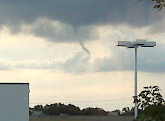
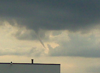
LANDSPOUT SIGHTED LOWELL, INDIANA!

On 12 August 2008 at around 6:50PM in Lowell, Indiana there was a confirmed funnel cloud sighted. However there was no meso effect or severe wx system on radar. The funnel lasted around 10 minutes, but never touched the ground. There was no danger. KLOT has recorded this funnel as a "landspout"! WGN 9 Meteorologist Tom Skilling sent these pictures to KLOT.


MARITIME NOTE

Coast Guard investigates Midnight fire and sinking
Written by Jeff Walls
Thursday, July 03, 2008

MOUNT DESERT — The sinking of the fishing vessel Midnight off of Mount Desert Rock is under a routine investigation by the United States Coast Guard.

David and Ryan Graves of Northeast Harbor abandoned the boat when it caught fire and began to sink about 20 miles offshore on June 17. The father and son escaped, but due to communication problems were not rescued from their life raft until roughly four hours after the boat went down. “We are doing an investigation but it is not a negative one by any means,” said Lt. Jason Smilie from Coast Guard Sector Northern New England on June 27. “It is more data collection to find out what actually happened and if everything in response happened the way it should have, if the lifesaving devices worked, like the life raft and things like that.”

According to early information, hydraulic fluid had somehow made its way on to either the engine, transmission, or exhaust, and caught fire. Ryan Graves said in his cell phone call to fellow fisherman Chris Candage that the boat had lost steering just prior to the fire being noticed.

“We do know that there was some hydraulic oil that was in the vessel that had leaked out that was noticed in the area,” said Lt. Smilie. “We are not hanging our hat on that as the cause, but something caused the vessel to burn.”

“What they are looking into is putting everyone’s statements together and trying to figure out what the final outcome is,” Lt. Smilie said. “Hydraulic fluid and a hot engine, that would be an ignition source, but we don’t know for sure.”

An emergency position indicating radio beacon (EPIRB) was required for this vessel according to Lt. Smilie, but they are not foolproof. “I believe there was an EPIRB on there. An EPIRB is one of those types of instruments where when it goes under water it floats free,” Lt. Smile said. “Water completes the contact and allows it to transmit. If there was a fire on board, then the fire could have gotten to it before the water did,” he said. “We don’t have any sort of automatic fire release that would jettison it or anything like that.”

As to why they crew didn’t call for help on VHF radio or manually activate the EPRIB, Lt. Smilie said, “The fire happened quickly and I am quite sure they were thinking ‘lifesaving’ just like anyone else because they don’t want to perish in the vessel.”

He said several things made the sinking different.

“Visibility was definitely an issue that day,” Lt. Smilie said. “Communications were also a problem. The distress came out on a cell phone and the cell phone service, especially on the ocean, is spotty.”

The Coast Guard is still trying to find the exact location of Midnight. “When the Coast Guard found them they noted that there was debris floating in the water,” said Lt. Smilie. “So that with the location of where they were found and the time frame they have a general area of where it is.”


RS