 Pioneering expeditions investigate how eddies make life bloom in oceanic deserts
 In the 87 days that Dennis McGillicuddy and colleagues spent in the Sargasso Sea in the summer of 2005, they were tossed around or chased by four hurricanes and two tropical storms: Franklin, Harvey, Irene, Maria, Nate, and Ophelia.
Not one of those massive storms was as powerful as the one swirling in the water beneath them.
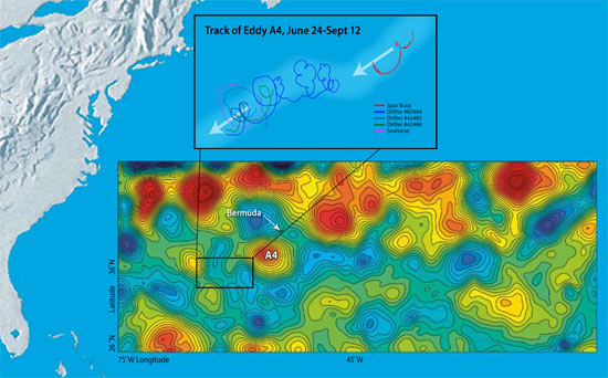
From June to September, McGillicuddy and a team of more than 20 scientists from Woods Hole Oceanographic Institution and five other marine science labs tracked an eddy named A4. It was the oceanic equivalent of a hurricane—a huge mass of water spinning like a whirlpool, moving through the ocean for months, stretching across more than 62 miles (100 kilometers), stirring up a vortex of water and material from the depths to the surface.
“Eddies are the internal weather of the sea,” says McGillicuddy, an associate scientist in the WHOI Applied Ocean Physics and Engineering Department. But unlike destructive hurricanes, eddies can be productive. As certain types of eddies stir the ocean, they draw nutrients up from the deep, fertilizing the waters to create blooms of microscopic marine plants in the open ocean, where little life was once thought to exist.
“The open ocean is twice as productive as we can explain based on what we know about nutrients in the water,” said McGillicuddy. “Where do all the nutrients come from to make these oases in the oceanic desert?”
Pump up the volume (of nutrients)
The Sargasso Sea—south and east of the Gulf Stream—forms the geographic center of the North Atlantic Ocean. It is warmer, saltier, bluer, and clearer than most other parts of the North Atlantic, except for the floating mats of sargassum seaweed that gave the sea its name. For centuries, prevailing wisdom was that such open ocean waters were mostly desert-like, unproductive regions.
A lecture on the Sargasso Sea in the early 1990s sparked McGillicuddy’s curiosity. In the talk, Bill Jenkins, a senior scientist in the WHOI Marine Chemistry and Geochemistry Department, pointed out that scientists were finding more oxygen being produced and consumed in the open ocean than anyone expected. The suspects were phytoplankton, microscopic marine plants that produce oxygen in photosynthesis, and zooplankton (microscopic animals) and bacteria, which use oxygen as they consume plants and organic detritus that sink to the seafloor.
Scientists found 10 times more microscopic life in the Sargasso Sea than anyone could explain, given the dearth of nitrate, phosphate, trace metals, and other nutrients that plants need to grow in sunlit surface waters. Researchers slowly developed the hypothesis that vortices of cold or warm water—eddies—might somehow act as a biological pump.
“I had proposed a problem, and Dennis suggested a solution,” Jenkins said. “He had the clever idea that eddies were perturbing the layers of the water column, mixing different waters, and bringing nutrients up from below.” The upwelling of nutrients into the euphotic zone (the top 330 feet or 100 meters of the ocean, where light penetrates) would stimulate prodigious blooms of phytoplankton, which attract zooplankton and other animals up the food chain.
The Eddies Dynamics, Mixing, Export, and Species composition (EDDIES) project was born.
Into the eye of the oceanic storm
“Dennis has wanted to do this experiment since he was a graduate student,” said Dave Siegel, a longtime collaborator with McGillicuddy and an oceanographer from the University of California, Santa Barbara (UCSB).
McGillicuddy mustered chemists, biologists, and physical oceanographers from WHOI, UCSB, Rutgers University, Bermuda Biological Station for Research (BBSR), Virginia Institute of Marine Sciences, Dalhousie University, and the University of Miami. Together, they secured $3.5 million from the National Science Foundation, as well as five months of ship time over two years on the WHOI-operated research vessel Oceanus and the BBSR-operated Weatherbird II.
The goal: to make detailed chemical, biological, and oceanographic measurements of a specific eddy by getting right into the middle of it.
“We didn’t want to just sit on the fence and watch from one point,” said Ken Buesseler, chairman of the WHOI Department of Marine Chemistry and Geochemistry. “Eddies move and develop, so we decided to follow a parcel of ocean as it moved. This was the first time anyone has really studied an eddy in this way.”
Toward a holistic view of scientific problems
Eddies are distinct parcels of water that move and jostle within the ocean, much like warm and cold air masses or high- and low-pressure systems in the atmosphere. Eddies are formed by differences in ocean temperature and salinity that give water different densities. Like oil and water, water masses of different densities tend to keep separate, rather than mix.
The largest eddies can contain up to 1,200 cubic miles (5,000 cubic kilometers) of water and can last for months to a year. Earth’s rotation—the Coriolis force—gives eddies their spin.
To hunt for their target, McGillicuddy and colleagues used data from satellites, whose measurements of sea surface heights show telltale signs of eddies. Warm-water eddies form bumps in the ocean; cold-water eddies form depressions. The team examined several eddies and settled on anticyclone No. 4, or A4, a “mode water” eddy (see "The Hunt for 18° Water") that stretched some 93 miles (150 kilometers) in diameter at the surface.
The EDDIES program took a truly integrated approach, combining many tools—satellites, ships, moorings, drifters, robotic vehicles, computer models—and many types of scientists.
From June 20 to Sept. 14, 2005, the researchers zigzagged across the eddy as it drifted southwest about 3.7 miles (6 kilometers) per day. The team on Oceanus buzzed around collecting water and nutrient samples, measuring current speeds and directions, and towing WHOI biologist Cabell Davis’ Video Plankton Recorder through the turbulent swirl. Bill Jenkins and his lab mates measured natural chemical markers such as tritium, an indicator of the amount of plant-fueling nitrate being raised from the depths. WHOI Senior Scientist Jim Ledwell, an expert on using tracers in the ocean, injected sulfur hexafluoride, a harmless chemical, into the middle of the eddy and tracked how it spread up, down, and across the sea.
At the same time, a research team on Weatherbird II made targeted measurements in the core of the eddy, measuring plant and animal productivity, the movement of particles, and thorium, a radioisotope that marks how much organic material is sinking from surface waters. Siegel used a radiometer to measure whether the eddy was disturbing the light penetrating the blue water.
“Ocean scientists are moving toward a more holistic view of their research problems,” said Siegel. “Ocean science grows by filling in the cracks between disciplines. If you put a smart and diverse group of people together in a boat, a lot of good things can happen. People start to think outside of their own little research worlds, and together we can tell scientific stories that we couldn’t put together individually.”
Stirring up a rich soup
Fueled by nutrients from the deep, diatoms bloomed to concentrations 10,000 to 100,000 times the norm—among the highest ever observed in the Sargasso Sea.
At the same time, the team was surprised to find historically low concentrations of oxygen in the depths, a sign of zooplankton and bacterial population explosions. It also meant that an awful lot of heat-trapping carbon dioxide may have been drawn out of the atmosphere and ocean surface, transformed by phytoplankton, and sunk to the bottom of the ocean.
Six months after the last EDDIES researcher stepped off Oceanus, the scientists are still assessing and analyzing the wealth of data they collected on A4. The team met in February 2006 at the international Ocean Sciences Meeting in Hawaii to share observations and collectively make sense of what they saw. Ultimately, the goal is to develop high-resolution computer models—McGillicuddy’s specialty—that can simulate and predict the full range of eddy dynamics.
The EDDIES project is a critical step toward comprehending these great ocean storms, whose sheer size and scale are daunting. During the expedition, tropical storm Harvey made a direct hit in early August, cutting a path right across eddy A4. The eddy hardly felt Harvey; the monstrous atmospheric storm never came come close to breaking up the potent, voluminous swirl of water in the ocean.
—Mike Carlowicz
The EDDIES project received funding from the Chemical Oceanography, Biological Oceanography, and Physical Oceanography branches of the National Science Foundation.
WEATHER STORY
One of the severe weather issues that face the Great Lakes Region is severe Ice Jam flooding. So what are Ice Jam Floods? As NWS (LOT) Chicago explains....
Ice Jam Flooding
Kankakee River Ice Jam at I-55 Feb 2007

Ice jams are resulting in flooding on some rivers in northern Illinois. The National Weather Service advises that if you come upon a flooded roadway, turn around, don’t drown! Also, do not attempt to drive around barricades placed at flooded roads. It only takes as little as 2 feet of flowing water to float many vehicles. More than half of all flood-related fatalities are a result of individuals attempting to drive through a flooded roadway.
What is an ice jam?
An ice jam is a stationary accumulation of ice that restricts flow. Ice jams can cause considerable increases in upstream water levels, while at the same time downstream water levels may drop, exposing water intakes for power plants or municipal water supplies. Types of ice jams include freezeup jams, made primarily of frazil ice; breakup jams, made primarily of fragmented ice pieces; and combinations of both.
Why are we experiencing so much ice jam flooding at this time?
Earlier this month, northern Illinois experienced warm temperatures that melted the existing snow in combination with heavy rainfall that resulted in near record flooding on some streams. Although water levels have receded since the near record levels, they remain well above normal for this time of year. These higher than normal flows are resulting in more substantial flooding when an ice jam forms.
Can you predict ice jams?
The National Weather Service monitors river levels at select gages on area streams, maintained and operated by the U.S. Geological Survey. However, ice jams can be very localized and the gage reading may not always reflect what is happening a few miles upstream or downstream from the gage. In addition, jams can form and break with little or no warning making ice jams very difficult to predict.
If you live along streams prone to ice jams you should continue to closely monitor river levels and listen for possible flood statements or warnings. When a jam forms, water can rise many feet in minutes versus hours and days in a normal river flood, and you may have little time to take action. Report ice jams and ice jam flooding to local authorities for relay to the National Weather Service.
MARITIME NOTES
m/v Kapitan Uskov disappeared in East China sea - 1/24/2008 02:41
January 24, 01.15 LT – message from Germes Co., Sovgavan port (vessel’s operator) – dry cargo Kapitan Uskov disappeared in approximately 31.40N 125.58E area, East China sea, last communication was at 03.00 January 20, didn’t arrive at port of destination ETA January 24. All vessels in area requested to keep a sharp lookout and assist if possible. Japan S&R sendind a plane, Shanghai S&R also informed, asked to assist.

NOAA – new Director of Office of Response and Restoration
The National Oceanic and Atmospheric Administration (NOAA) issued a news release stating that Mr. David Westerholm has been appointed as the new Director of the Office of Response and Restoration. (1/22/08).
READERS COMMENTS - CAPTAIN DUNSEL
Moreover if I make a mistake and its pointed out I normally thank the commenter and post the correction after the mistake has been vetted, (IF) the commenter has done so constructively. But in Mr. Paul Williams case (if that is his or hers real name) this "Captain Dunsel" posting deserves a reply on my blog.
Mr. Paul Williams writes,
"Paul Williams has left a new comment on your post The M/V Aratere Incident"
The video fottage attached to this story is of one of the Strait Shipping vessels, NOT an Interislander vessel and certainly NOT the Aratere. If you're going to post these sorts of messages and attach video footage then at least get it right. The interislander vessels are consideralbly larger than the Strait Shipping vessels, so this video is very misleading."
Mr. or Mrs. Williams here is referring to my posting of Tuesday, August 28, 2007 on The M/V Aratere Incident and my posting of Friday, June 8, 2007 Another Plane Of View. Where I posted a picture of the M/V Aratere instead of one of Strait Bluebridge Ferry Service Passenger Ferries the Suilven. Well Mr. Paul (Captain Dunsel) Williams, many of us once and a while do make the wrong ship identifications. We all make mistakes. And after reviewing the video (fottage) footage I did in fact ID the vessel as Straits Suilven. You were correct. You get a cookie for this.
But lets talk about the rest of Captain Dunsel's posting and ship particulars here while missing the entire point. Captain Dunsel says "The interislander vessels are "consideralbly" larger than the Strait Shipping vessels". The Suilvan came out of service in 2003. So we can only gauge Straits (Santa Regina or the Monte Stello) against the Aratere. The M/V Aratere's length is 150m or 492ft, has a beam of 20.25m or 66ft and its Gross Tonnage is 12,300. The Santa Regina has a length of 137m or 449ft with a beam of 22.5m or 73ft with a Gross Tonnage of 14,588. The Monte Stello has a Length of 126.5m or 415ft with a beam of 21m or 68ft and with a Gross Tonnage of 11,630.
The difference between the ships? Aratere Vs. The Santa Regina? Length 43 ft and a beam difference of 25 ft to Aratere's favor. While the Santa Regina is heavier by 2200 Gross Tons. The Aratere Vs. The Monte Stello? Difference in length? 77ft and a beam difference of 68ft. Length favors Aratere and the beam favors the Monte Stello and not the Aratere, while the tonnage difference is only 670 Gross Tons.
Well Captain Dunsel in the terms of ship particulars of this class of vessel your definition of "consideralbly larger" is slightly off base like your spelling and really a false flag. These ships are very close in general arrangements. While I should have spent more time in identification, which I take full responsibility for. Though I was not the only one to make this mistake it seems.
Moreover the size difference between these vessels really does not make that big of a difference nor is it misleading in any sense as Captain Dunsel notes. The wave actions vs. the ships maneuverability tells the real story, so does the crews and passengers. And that was the point!! It did not make a difference that day, any one of these ships would have encountered almost the same problems. Though the Aratere nearly capsized...
Thank You Captain Dunsel for your posting. I have made the corrections. Next time please have the courtesy to email me directly or send me a posting with both your email addy and your constructive criticisms....
RS





















![[Valid RSS]](valid-rss.png "Validate my RSS feed")