Tuesday, June 10, 2008

COLORADO STATE UNIVERSITY HOSTS ONE OF THE WORLD’S MOST ADVANCED WEATHER RADARS

COLORADO STATE UNIVERSITY HOSTS ONE OF THE WORLD’S MOST ADVANCED WEATHER RADARS

Note to Editors: Information recorded by CHILL on the May 22 Windsor, Colo., tornado can be found at - Colorado State University this spring installed a unique antenna on one of the nation's most advanced polarimetric weather radars to more precisely detect major storms and precipitation. The new antenna gives scientists a "more delicate knife" to evaluate thunderstorms and the size and distribution of rain, hail and snow, said Steven Rutledge, professor of atmospheric science at Colorado State and the scientific director of the CSU-CHILL radar facility.

The radar, located next to the Greeley-Weld County Airport and known as CSU-CHILL, has the capability of seeing a single hail stone in the atmosphere more than 10 miles away. So-called dual polarization technology will be adopted as the new National Weather Service standard starting next year and deployed on the nation's WSR-88D radars, used to warn the public about developing severe weather. The CSU-CHILL radar supports this effort by developing new techniques that will be used on the weather warning radar network.

The CHILL facility is jointly operated by the Colorado State University departments of Atmospheric Science and Electrical and Computer Engineering. In addition to Rutledge, V.N. Bringi and V. Chandrasekar, professors of electrical engineering, serve as principal investigators on the award from the National Science Foundation, which exceeds $3 million over a three-year period.

CHILL has been at Colorado State University since 1990 under continuous support from the National Science Foundation and the state of Colorado. Using its unique dual-polarization technology, the CHILL provided unprecedented data on the July 1997 Spring Creek Flood in Fort Collins, recording a more accurate rain amount by nearly 5 inches than what the National Weather Service radars measured during the storm.

The new antenna technology was installed in February as the result of a three-year, $1.4 million National Science Foundation grant led by Bringi. The antenna was custom designed and manufactured by VertexRSI, a division of General Dynamics, in Killgore, Texas, which provided $250,000 worth of in-kind support for the project. The installation of the antenna marked the first time this type of antenna technology has been installed on a weather radar anywhere in the world.

"We'll get much more precise measurements with this new antenna technology," Rutledge said. "We can better detect heavy rain and hail. That's important to tracking flooding rains and damaging hail more precisely."

The dual polarization measurements are so valuable that the National Weather Service will adopt this technology in its national network of 150 warning radars. The National Weather Service will implement dual polarization radar capabilities starting in 2009 and expects to complete the installations by 2010. Previous radar network upgrades occurred in 1957 and 1988.

Dual-polarization works by transmitting and receiving both horizontal and vertical radiation. This technique allows better discrimination of particle shapes, which allows more accurate information to be gathered on rain and hail, snowflakes and other particles in clouds.

"The integration of CSU CHILL dual polarimetric capabilities into the nation's weather radar network represents a major milestone in our effort to address the ever increasing demand for accurate forecast and warning services," said Larry Mooney, meteorologist in charge of the National Weather Service office in Boulder.

CHILL is an S-band frequency radar - the frequency currently used by the National Weather Service - that operates at 3 gigahertz. The antenna is housed within an inflatable dome for protection against wind and precipitation.

"Some of the most exciting developments in radar took place over the last decade, and we played a role," said Bringi. "The new technology helps us understand the finer structure in storms. We can demonstrate the advancement of the science of meteorological radar right here at CSU."

The radar can give scientists an idea of what's coming about four hours in advance. But the information also helps make models used in weather forecasting more intelligent.

"We use the observations and the radar as the primary tools to improve the modeling," Bringi said.

Chandrasekar has used the radar as part of testing a sophisticated network of radars in Oklahoma's tornado alley to improve early warning systems for tornadoes and severe thunderstorms The radars are in or near Chickasha, Lawton and Cyril and Rush Springs, Okla., but Colorado State faculty and students monitor the radars 24 hours a day, seven days a week from computers in the College of Engineering.

In 2003, Colorado State teamed with universities across the nation in the National Science Foundation Engineering Research Center for Collaborative Adaptive Sensing of the Atmosphere, or CASA, to develop a network of radar systems. The University of Massachusetts at Amherst is the lead institution. The radar system in the Oklahoma test bed is the result of a multidisciplinary collaborative effort among all of CASA's partners: Colorado State, UMass, the University of Oklahoma and the University of Puerto Rico.

CASA's primary mission is to develop a Distributed Collaborative Adaptive Sensing radar network at higher frequencies than CHILL radar such as X-band. The S-band frequency is used by the current nationwide deployment of weather radars. X-band is about three times the frequency of S-band. This higher frequency is needed to make smaller and less expensive radars compared to a radar like CHILL.

More fun facts about the CSU-CHILL radar:

- History: The original CHILL radar was assembled in 1970 by the University of Chicago and the Illinois State Water Survey, which is where the radar gets its name. It was moved to CSU in 1990.

- Staff: Requires three full-time staff - Pat Kennedy, Dave Brunkow and Bob Bowie. (A fourth staff member, recent electrical engineering master's graduate Jim George, is being hired.)

- Antenna: When the antenna is looking straight up, the highest point of the antenna is approximately 50 feet above the ground. The antenna is made of aluminum and weighs nearly 6,000 pounds.

- Dome: 64 feet tall and 100 feet in diameter at the base; weighs 8,000 pounds; consists of the same nylon-reinforced vinyl used in the concourse tents at Denver International Airport. Dome cost is $500,000.

- Power: CHILL transmits a peak power of 1 million watts.

WEATHER NOTE

Preparing For Hurricanes
During Disasters, Radio Operators Play A Big Role

Kathy Waters/Highlands Today

From left: Larry Ambuel demonstrates how to send an email using a radio signal as amateur operator Randy Payne watches Tuesday at the Hurricane Expo at the Highlands County Agri-Civic Center in Sebring.

Published: June 4, 2008

SEBRING — When the lines of communication go down during a disaster, ham radio operators can help local rescue crews exchange vital information.

If power goes out, the phone lines fail, the cell phone towers don't work and Internet access is down, hams provide that missing two-way communication link that can save lives.

During Tuesday night's Hurricane Seminar at the Agri-Civic Center, led by Emergency Management Director Bill Nichols, several ham enthusiasts were on hand to talk to the public and demonstrate cutting-edge radio technology.

Hams are often known simply by their FCC call signs. At Tuesdays seminar, K4EZM (Randy Payne, of Sebring), AA4ME (Fred Seely, of Avon Park) and AA8QS (Larry Ambuel, of Sebring), talked about serving during the 2004 hurricane season.

About 20 active local hams are members of the national Amateur Radio Relay League. The local chapter is the Highlands County Amateur Radio Club, with those at Tuesday's event a sub group of that branch –– the Amateur Radio Emergency Service (ARES).

Payne broadcast from the Agri-Civic Center, which was one of about nine county shelters in 2004. He transmitted hourly updates to the Emergency Operations Center and response teams concerning the shelter, including the number of residents and staff, emergency medical situations and the amount of supplies available.

"It's a labor of love to take a hobby I very much enjoy and to help other people," said Payne.

Nichols said that the hams are one of the strongest volunteer groups the EOC works with.

"They're so strong and so good; they're not our backup communications, but our primary," said Nichols. "They're so good at what they do, we don't use the phones (during past hurricanes). They're professional, reliable and they are there."

On Tuesday, Ambuel sent an e-mail identical to one written on a conventional computer, but broadcast through ham radio airwaves. Ambuel faced the brunt of Hurricane Charley while working in Punta Gorda. READ>

MARITIME NOTE

Two People Saved After Boat Sank

NEW YORK-Two people were rescued from a life raft after their sportfishing vessel sank approximately nine miles off the coast of Moriches, N.Y., at about 5:45 p.m., today.

Greg Mastonardi, owner of the 33-foot Topaz sportfishing boat First Light, was transiting between Egg Harbor Inlet N.J., to Shinnecock Inlet, N.Y., with passenger Mark Edwards, when he called Coast Guard Sector Long Island Sound to notify them his boat was taking on water and his dewatering pumps were having a difficult time keeping up. The Coast Guard instructed Edwards and the other passenger to put on their life jackets.

"We launched a 47-foot motor life boat from Coast Guard Station Shinnecock, a 27-foot rescue boat from Station Moriches, and a HH-60 rescue helicopter from Air Station Cape Cod immediately," said Peter Winters, a civilian search and rescue controller at Sector Long Island Sound.

Nine minutes later, Mastonardi notified search and rescue controllers at Sector Long Island Sound that water was overtaking the vessel and he was going to have to abandon ship.

"We asked them to activate their Emergency Position Indicating Radio Beacon (EPIRB) right before we lost communications with them," said Winters. "Seatow overheard Mastonardi call to Sector Long Island Sound and told us they were nearby. We passed their position to Seatow and they headed towards the location."

Seatow arrived at 6:03 p.m. where they pulled Mastonardi and Edwards from their life raft to safety. The First Light sank in 108-feet of water. READ>

The Coast Guard's Most Extreme Rescue: Cover Story Preview Before dawn on March 23, 2008, the Alaska Ranger ship sank in America's deadliest waters.

As 47 souls fought for survival, the Coast Guard launched one of the most daring and dramatic rescues in history. Read an exclusive excerpt from “Ranger Down,” watch author Kalee Thompson track the mission on PopMech TV, hear the Mayday call, browse Coast Guard gear with interactive graphics, then pick up the July issue of PM for the full story!


RS

Monday, June 9, 2008

NOAA Satellites Primed for Spike in Summer Distress Calls

NOAA Satellites Primed for Spike in Summer Distress Calls

As the heat of summer lures more boaters, campers and hikers to the great outdoors, NOAA satellites are primed for an inevitable spike in distress signals from emergency locator beacons.

Through May, 139 people have been rescued in the United States this year. In 2007, a record 353 people were rescued from potentially life-threatening emergencies thanks to NOAA’s polar-orbiting and geostationary satellites, which form part of the international Search and Rescue Satellite-Aided Tracking System, called COSPAS-SARSAT.

This high-tech system uses a network of satellites to quickly detect and locate distress signals from emergency beacons onboard aircraft, boats and from the handheld personal locator beacons. Now in its 26th year of operation, COSPAS-SARSAT has been credited with more than 23,000 rescues worldwide, including nearly 6,000 in the United States and its surrounding waters.

SARSAT statistics show a significant increase in rescues during the spring and summer seasons compared to colder weather months:

  • In 2007, 87 rescues were made in the United States between January and March, but 111 people were saved between June and August.
  • In 2003, 24 rescues occurred between January and March, but during the June – August period that number quadrupled to 96 lives saved.

“During the summer, we typically see a big jump in rescues because more people are out enjoying the warm weather,” said Chris O’Connors, program manager for NOAA-SARSAT. “But anyone planning to hike or camp this summer in a remote area where cell phone service is not reliable, or sail a boat far from shore, should not leave home without an emergency beacon registered with NOAA.”

When a satellite pinpoints a distress location within the United States, or its surrounding waters, the information is relayed to the SARSAT Mission Control Center at NOAA’s Satellite Operations Facility in Suitland, Md. The information is then sent to a Rescue Coordination Center, operated either by the U.S. Air Force, for land rescues, or the U.S. Coast Guard, for maritime rescues.

Older emergency beacons, which operate on the 121.5 and 243 megahertz (MHz) frequencies, will be phased out by February 1, 2009. That’s when 406 MHz beacons will become the new standard. Key reasons for the switchover include the ability of the 406 MHz beacons to be detected instantly; they are more accurate, and provide Search and Rescue responders with important registration information -- features the older beacons do not offer.

“We are encouraging all 121.5 MHz beacon owners to make the switch to 406 now, so their distress signals will always be answered,” said NOAA Corps Lt. Jeffrey Shoup, who is the support officer for SARSAT operations.

Shoup added, “There have already been a handful of aviation rescues this year attributed to the 121.5 frequency beacons, mostly in Alaska, but after February 1, such rescues by the SARSAT system will no longer be the case.”

The National Oceanic and Atmospheric Administration, an agency of the U.S. Commerce Department, is dedicated to enhancing economic security and national safety through the prediction and research of weather and climate-related events and information service delivery for transportation, and by providing environmental stewardship of our nation's coastal and marine resources. Through the emerging Global Earth Observation System of Systems (GEOSS), NOAA is working with its federal partners, more than 70 countries and the European Commission to develop a global monitoring network that is as integrated as the planet it observes, predicts and protects.

WEATHER NOTE

Indiana storms spawn 3 tornadoes

June 4, 2008 - 11:05AM

INDIANAPOLIS (AP) - Thunderstorms cut through south-central Indiana on Tuesday, spawning at least three tornadoes and causing widespread damage.
Tornado watches and flood watches or warnings remained in effect in the central part of the state this morning.

The National Weather Service tracked two tornadoes on the ground south of Indianapolis that triggered significant damage reports Tuesday night.

One storm was initially reported near St. Paul on the Shelby-Rush-Decatur line southeast of Indianapolis, where damage was reported to utility poles and wires were torn down. Weather Service meteorologist Joseph Nield said the same tornado apparently hit the village of Moscow in southern Rush County.

A dispatcher with the Rush County Sheriff's Department said this morning there were six injuries and no fatalities. The extent of the injuries was unknown. The storm destroyed a covered bridge in Moscow and damaged or destroyed several homes.

Another tornado was reported near Princes Lake north of Columbus and apparently then moved east to Edinburgh, meteorologist Logan Johnson said. A Johnson County sheriff's dispatcher said several tornado touchdowns were reported in the Edinburgh area. Damage also was reported in nearby Camp Atterbury.

Earlier in the day, the Weather Service said a small tornado touched down near Waverly, where television reports showed several trees down and buildings damaged.

Scattered damage was reported throughout central Indiana, and at one point more than 4,600 people were without electricity because of the storms. Power had been restored to about half of them by 11 p.m., Duke Energy reported on its Web site. Most of the outages were in Shelby County just southeast of Indianapolis and Wayne County in eastern Indiana.

One man suffered a broken foot Tuesday when storms damaged houses and trees about four miles north of Bedford, the Weather Service said.

Wind damage and heavy rain were reported in several areas and flash flooding warnings were issued.

Indiana Storm Damage

(Robin's note..... It's been one heck of a week and weekend. Not only did Indiana and Illinois have twisters but they also had a major and excessive rain event. 4.25" inches of rain fell in a matter of two to three hours.

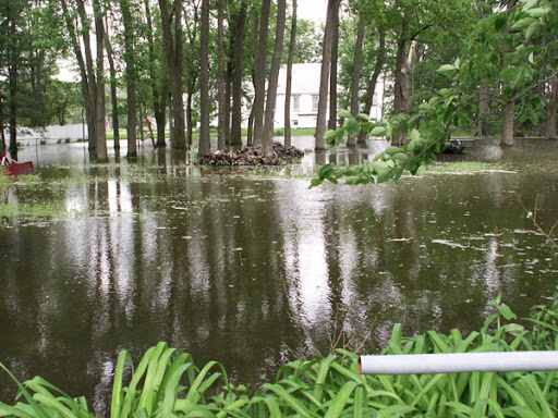
These photo's were taken between June 4, thru 8th in the Wheatfield, Tefft and Demotte (Jasper County) and at Dunes State park in porter County Indiana of flood and storm damage.

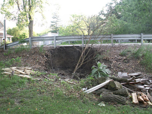
The crop damage done by these supercells was extensive. On these days four wall clouds were spotted. There was also a twister report which is being investigated by KLOT just east of Rensselaer Indiana. The excessive rain also eroded away the bank of Dunn's Bridge on the Jasper/Porter County line where as now the bridge must be rebuilt.)

Delete caption
Flood damage in Teft, Indiana

Roadway damage to Dunn's Bridge


Business flooded on RT 49 & 10 in Wheatfield
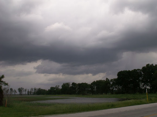
Farm field flooded in DeMotte


Home amd field flooded in DeMotte

Supercell over Wheatfield


Shelf Cloud Along Dunes Beach, June 8th


Tornadoes of June 7th

Below is a photograph taken of a large tornado across Will County Saturday afternoon.

Photo received from Amy Pavlik

TORNADO JUNE 7TH LOOKING WEST BETWEEN PEOLONE & MONEE

Taken over Green Garden Golf Country Club by Michael Jadzak of Green Garden Township.
Photo by Michael Jadzak


June 7th TORNADO NEAR O"DELL ILLINOIS


Maritime Note

Remembering The Edmund Fitzgerald

Model of the Edmund Fitzgerald

50 Years ago today the most infamous vessel of the Great Lakes was launched. Farlane writes:

It was a beautiful Saturday afternoon on June 7th, 1958, as more than 10,000 people lined the banks of the Detroit River. They had come to witness the launching of Hull 301 at the Great Lakes Engineering Works of River Rouge, Michigan. Mrs. Edmun Fitzgerald, wife of the president of the Northwestern Mutual Life Insurance Company for which the ship was named, christened the brand new ship and at 12:34 p.m. the 729 ft. “Edmund Fitzgerald” slid gracefully into the basin amid cheers, salutes, and well wishers. READ>

Man Safe After Drifting Two Days at Sea

PORTSMOUTH, Va. - Robert Brakes, a 60-year-old Morehead City, N.C., resident, is safe today after being rescued from a life raft off the North Carolina coast by the Coast Guard.

Brakes reported that his ordeal began after his sailboat began taking on water and capsized Wednesday evening.

"He reported that he attempted to contact help with his vessel's radio but was unsuccessful," said Lt.j.g. Scott McGrew of Coast Guard Sector North Carolina.

"He said his vessel sank so quickly he was unable to gather food, water or his ship's Emergency Position Indicating Radio Beacon (EPIRB)," said McGrew. READ>


RS

Friday, June 6, 2008

Coast Guard cleans up spill after freighter sinks docked boat on Cuyahoga River

Coast Guard cleans up spill after freighter sinks docked boat on Cuyahoga River

CLEVELAND - A Great Lakes freighter carrying a load of gravel sliced and sunk a 36-foot boat docked along the west bank of the Flats Sunday night.

Elvin Jones, of Shaker Heights, had just tied up his boat, the Beverly II, along the Cuyahoga River. He and a friend were eating dinner at Shooters on the Water when the collision happened.

"We saw the crowd running and we decided to come out and see what was happening," Jones said. "Then I found out we were part of the action, the main course."

No one was injured. A second boat at the dock belonging to the owner of Shooter's Restaurant was also damaged. Jones' boat was no match for the freighter, The Cuyahoga. The fiberglass powerboat sank in just a few minutes.

According to Coast Guard Lieutenant Commander Linda Sturgis, the freighter regularly travels the Cuyahoga River.

"Standard protocol would require a drug test (of freighter pilot)," Lt. Commander Sturgis said. "We'll get witness statements, check charts, recheck the track line and the weather, interview the master and interview who was on watch."

John Granzier saw the collision slowly unfold. "(The Cuyahoga) just barreled into the middle of the boat and crushed it," Granzier said. "Before that we saw a guy running back and forth (on the freighter). We didn't realize something was going on. So they must have noticed that they were getting real close."

Jones looked at his boat submerged in the water Sunday night and shrugged his shoulders.

"No one was hurt. That's the most important thing," Jones said. "And the boat is insured. Hey, things can be replaced."

Meanwhile, many boaters wonder if lake freighters should be required to use tugboat when they enter the Cuyahoga River. Most of the big lakers use bow and stern thrusters to navigate the many turns of the river.

From the patio deck of Shooter's Restaurant, you can quickly see that the Cuyahoga is a working river. There is a delicate balance between the passing lake freighters and the dozens of pleasure boats. READ>

WEATHER NOTE

Forecaster expects busy Atlantic hurricane season
REUTERS
7:40 a.m. June 3, 2008

MIAMI – The 2008 Atlantic hurricane season will likely be a busy one with 15 tropical storms, of which eight will turn into hurricanes, the noted Colorado State University forecasting team said Tuesday.

The prediction from the research team founded by hurricane forecasting pioneer William Gray was unchanged from the one CSU issued in April, which called for four of the eight hurricanes to become “major” storms, the most destructive type, with sustained winds of more than 110 miles per hour.

The average hurricane season produces roughly 10 tropical storms and six hurricanes.

The CSU forecast said warm Atlantic sea temperatures, along with low pressure at the ocean's surface and low levels of vertical wind shear, would contribute to an above-average season.

Hurricanes draw energy from warm water, while vertical wind shear, a difference in wind speeds at different altitudes, can disrupt nascent storms.

“Conditions in the tropical Atlantic look quite favorable for an active hurricane season,” lead forecaster Phil Klotzbach said in a statement.

The official six-month Atlantic hurricane season began on Sunday. The first cyclone of the year, Tropical Storm Arthur, formed a day earlier off the coast of Belize and moved quickly inland.

The storm lasted less than a day before weakening to a tropical depression, but it still forced Mexico to shut two of its three main crude oil ports because of rough seas.

Arthur drenched southern Mexico, Belize and Guatemala, threatening deadly flash floods and mudslides.

Klotzbach said forecasters were closely monitoring sea temperatures in the eastern Pacific for the development of El Niño, a warming of ocean water that can dampen hurricane activity in the Atlantic.

“At this point, we do not believe that an El Niño will develop by late this summer,” he said. READ>

U.S. tornadoes far above average this year

OKLAHOMA CITY (AP) — There have been more Oklahoma reports of tornadoes so far in 2008 than typically occur in an entire year, according to preliminary data from the National Weather Service.

"The atmosphere is sort of switched on to tornadoes or switched off," said Harold Brooks, a research meteorologist at the National Severe Storms Lab in Norman. "This year, we're on."

Less than halfway through the year, Oklahoma has had 54 tornado reports. A total of 53 tornadoes hit the state in the average calendar year. There have been six tornado deaths in the state this year, which is more than in any year since 1999.

The USA as a whole also has seen far more tornadoes and tornado deaths than usual, with 1,258 tornadoes and at least 110 deaths reported so far in 2008. That's more deaths than in any year in a decade, and a "huge number" of tornado deaths for modern times, Brooks said.

The national death toll this year already is more than twice the 20-year average, said Greg Carbin, warning coordination meteorologist at the NOAA Storm Prediction Center, also in Norman. In the last three years of full data, the average number of tornadoes has been 1,159.

The meteorologists said the high numbers could be linked to long-term trends in weather and climate, such as climate change or La Nina, which is a weather pattern associated with ocean temperatures.

But overall, active tornado years are just hit or miss, the meteorologists said, in part because their formation is dependent both on regional weather systems and local conditions, which actually spark the twisters.

Climate change could increase the frequency of severe storms, Carbin said, but it may also reduce wind shear, which occurs when winds of different speeds or temperatures pass each other. Wind shear is a key ingredient in tornado formation, he said, so how those two factors balance is unclear.


Storm Report

MARITIME NOTE

(Robin's Note: The following article is one of the reason why failure investigations of Coast Guard Certified and Inepected Life Safety Equipment such as, EPIRB's is hampered.)

Coast Guard maritime casualty investigations hindered by poor management, IG finds

For more than six decades, the Coast Guard has been charged with investigating maritime accidents that result in death, injury or substantial property or environmental damage. The primary objective of a maritime casualty investigation, which can range in scope from preliminary information gathering to a formal inquiry depending on the severity of the accident, is to identify safety issues (other agencies are responsible for determining civil or criminal liability). But a new report raises serious questions about the Coast Guard's ability to adequately carry out this mission.

While the investigations are considered an essential element of the service's safety program, investigators more often than not fail to meet the agency's own qualification standards. A new report by the Homeland Security Department's inspector general suggested the Coast Guard was missing opportunities to issue safety al9999erts or recommendations that could prevent or minimize similar casualties.

During site visits to Coast Guard stations, auditors found that 68 percent of investigators did not meet the agency's qualification standards. In addition, the Hampton Roads sector in Virginia had established its own criteria for qualifying investigators based on knowledge of local industry, waterways and jurisdictions, as well as interviewing techniques and chemical testing. The New York sector had adopted a similar training and qualifications program modeled after the Hampton Roads criteria, but neither sector had received headquarters' approval to use the revised standards, which contributed to inconsistency across the service.

In September 2007, the Coast Guard issued a plan to improve the maritime safety program, including revised qualification standards for investigators, "which both added to and detracted from the qualifications for marine casualty investigators," the auditors found. The new standards updated tasks investigators must perform, but they removed a pre-qualification for working with hulls or machinery and small vessels. Knowledge of these areas is essential to correctly identify the causes of accidents and to issue appropriate alerts and recommendations, the report said.

Auditors also reported that investigations were conducted improperly and a substantial backlog of cases was closed by headquarters without proper review. "As a result, the Coast Guard may not be able to determine the causal factors of accidents and, therefore, prevent or minimize the effects of similar casualties," the IG reported.

The Coast Guard concurred with the IG's findings and generally accepted the auditors' recommendations. Central to the plan is a 2009 budget request to hire 276 additional maritime safety employees, which represents a 40 percent increase in inspectors and investigators.

n Thursday, the Coast Guard released its five-year Marine Safety Performance Plan outlining the service's goals. The document details links between the mission, strategic goals, objectives and performance. Tellingly, it identifies the "need to increase the competency of inspectors and investigators as well as their knowledge of actual industry practices beyond that taught through normal training opportunities." The Coast Guard will accept public comments on the document during the next 60 days.

"The most significant threat to the Coast Guard's Marine Safety professionalism is insufficient human resource capacity to be responsive to the regulated marine industry," the plan noted, adding that "capability in the Marine Safety mission area has declined while the complexity, novelty and technological advancements used in the design, construction, and operation of ships and offshore systems have grown rapidly."

According to the IG report, between Jan. 1, 2003, and Oct. 31, 2006, the Coast Guard conducted 15,327 investigations, but the majority -- 93 percent -- never progressed beyond the data collection stage. There are four levels of investigation: preliminary information gathering, data collection, informal investigation, and formal investigation. The highest level is required when accidents result in two or more deaths, property damage exceeds $1 million, or there is a major oil spill, defined as 10,000 gallons in inland waterways and 100,000 gallons in coastal waters.

The Coast Guard commandant could convene a Marine Board of Investigation if a marine accident is of such significance that a detailed formal investigation is in the public interest. While the service has conducted 282 Marine Boards since 1947, only two have been convened since 2001. After the Alaska Ranger fish processing vessel sank on March 23, resulting in four deaths and one missing sailor, Commandant Adm. Thad Allen convened a Marine Board. Prior to that, the most recent board was convened in April 2001 after the Arctic Rose sank in the Bering Sea. The decline in convening Marine Boards is due primarily to the extensive resources needed to support them, the IG found.

Newcastle Port to Reassess Coal Ship Restrictions (Update2)

By Gemma Daley and Angela Macdonald-Smith

June 5 (Bloomberg) -- Australia's Newcastle port, the world's biggest coal-export harbor, will assess today whether to lift restrictions on ship movements as high seas and strong winds ease.

One coal ship left the port this morning and conditions will be reassessed at 1 p.m. local time to decide whether to relax curbs further, said Keith Powell, a spokesman at Newcastle Port Corp., in a phone interview today. No ships have entered the port today, with 17 anchored and waiting to gain access, he said.

A severe weather warning for parts of coastal New South Wales state, including the Newcastle area, was canceled at 8:15 a.m. Sydney time by the Bureau of Meteorology. The port yesterday stopped ships entering and halted almost all departures because of high seas and gale-force winds.

The price of coal has surged to a record this year as bottlenecks at ports constrained shipments and supplies in China and India dwindle.

The weekly price index for power-station coal shipped from Newcastle surged $13.35, or 9.6 percent, to $151.70 a metric ton in the week ended May 30, according to the globalCOAL NEWC Index. The running week-to-date index was at $157.29 a ton yesterday, up $3.60 from the previous day, globalCOAL said in an e-mail.

The price has almost tripled from $56.35 a ton a year ago.

Rio Tinto Group, Xstrata Plc and BHP Billiton Ltd. are among mining companies that ship coal through Newcastle.

Maritime emergency communications center established

Maritime emergency communications center established

SEATTLE - Coast Guard Auxiliary Flotilla 41, which provides volunteer civilian support to the Coast Guard in the Port Ludlow area, has established a new maritime Emergency Communications Center (ECC) co-located with Port Ludlow Fire & Rescue and Jefferson County Amateur Radio Emergency Services (ARES).

The new facility contains radio equipment to provide communication services for the Coast Guard and the Jefferson County Emergency Operations Center, in collaboration with the Port Ludlow Preparedness Council. It is used in routine and emergency Coast Guard operations and in overall disaster preparedness for the citizens of Port Ludlow and Jefferson County.

Since operations began at the new communication center earlier this year, the Coast Guard Auxiliary has used the facility for normal and emergency operations, including monitoring of Coast Guard marine radio channels, weekly emergency radio network drills, Auxiliary boat crew and communication training, man overboard drills, and supporting the Coast Guard in search and rescue.

Don Millbauer, Communications Officer for Division 4 of the Auxiliary said, “This creative partnership increases Auxiliary support to the Coast Guard and enhances coordination among all local responders by facilitating communication on land and water throughout Jefferson County.”

The new facility replaces a previous arrangement in which the Auxiliary’s communications were operated from a trailer. Millbauer approached Port Ludlow’s Fire Chief, Ed Wilkenson, with the idea of establishing a more accessible communication center at the local fire station. Chief Wilkenson enthusiastically endorsed the concept. He added the idea of including ARES in the center, to provide local interface with the Jefferson County Emergency Operating Center (EOC) in Port Hadlock. The fire department assisted with construction of the radio room within the fire station and moving the Auxiliary’s equipment.

Captain Stephen Metruck, Commander of Coast Guard Sector Seattle, said, “This initiative in Port Ludlow is a step forward in more effectively employing the Auxiliary in disaster response. The Sector is exploring similar ways to collaborate with local public safety response centers throughout our area of responsibility.”


Messing About In Ships Podcast


Have a great and enjoyable weekend!

RS

Thursday, June 5, 2008

Tornados, Flooding May Warn Of Climate Change

Tornados, Flooding May Warn Of Climate Change

ScienceDaily (Jun. 4, 2008) — Record-keeping meteorologists at the National Oceanographic and Atmospheric Administration say this year’s tornado season is one of the deadliest in a decade and may be on pace to set a record for the most tornadoes. And flooding in the Midwest has been at 100-year levels this spring.

“There is considerable concern that climate change due to greenhouse gases species increasing will lead to the enhancement of strong, large storms occurrences, such as hurricanes that also spawn tornadoes when they occur. Increased storm strengths also bring flooding events,” he said.

Gaffney and co-researcher Nancy A. Marley are currently involved in a three-year investigation of aerosols – tiny particles suspended in the air – and their role in climate change.*

Tornadoes are short-lived events and, until recently, scientists had to depend on limited ground observations to study them. Satellites and radar systems are now enhancing researchers’ ability to see their number and strength in detail. But short lived tornadoes are hard to tie directly to climate change due to the limited climatology of tornadoes.

Weather forecasters have examined El Niño and La Niña, important temperature fluctuations in surface waters of the tropical eastern Pacific Ocean, as a potential for past tornado activities in the U.S.

“The data available from NOAA do not support a strong statistical significance to data for direct effects of El Niño or La Niña on frequency or strength of tornadoes,” Gaffney said. “Although, there is considerable concern that climate change due to greenhouse species will lead to significant changes in weather patterns, these currently available data are not conclusive.”

He said the Intergovernmental Panel on Climate Change’s report on severe weather events discusses the topics backed up by NOAA data.

“Basic thought is there’s more energy in the atmosphere, more water vapor evaporating and greater likelihood for stronger heating events that lead to stronger thunderstorms - super cells, that can lead to tornado production,” Gaffney said.

He said tornadoes are complex phenomena that are linked to the number of super cells and their storm strengths. Flooding events are more wide spread than tornadoes, and are more readily tied to climate predictions than tornadoes.

“What we are looking to see, in current and future research and data acquisition, is whether the frequency and strength of tornadoes change as we continue to increase the energy distribution in the atmosphere,” he said. “Currently, this year is looking to be significantly larger in the number of tornadoes seen than in the past few years. That and the record floods that are associated with these strong storm systems, may be a warning of things to come. But more data gathering is needed.”

Gaffney points to the improved Doppler radar systems that have allowed tornado warning times to be advanced as the main tool for gathering this tornado climatology that will be needed to evaluate links between climate change and severe weather events.

*The $625,000 study is funded by the Department of Energy Atmospheric Science Program. He and Marley will discuss severe weather and links to climate during their annual orientation for the DOE Global Change Education Program.

CHICAGO SEVERE WEATHER UPDATE

Storm Reports-June 4th/5th

Severe Storm Reports: June 4th-5th


WEATHER NOTE

RMS Launches New U.S. Hurricane Loss Index

Catastrophe risk modeling firm Risk Management Solutions (RMS) has launched a new index for assessing insured industry losses from U.S. hurricanes.

Named the Paradex U.S. Hurricane, it combines actual wind speeds at multiple locations with proprietary industry exposure data, according to RMS. Its insured loss estimates can be used by the insurance industry and capital markets to structure catastrophe bonds, industry loss warranties, and derivative contracts.

Paradex U.S. Hurricane offers industry loss estimates by region and line of business in nine identified hurricane-prone zones throughout Florida, the East Coast, and the Gulf Coast. In the event of a hurricane, wind speeds are obtained from a network of hurricane-hardened weather stations constructed by WeatherFlow, a leading provider of weather data. This data is then referenced against RMS insurance industry exposure and vulnerability curves to calculate final index values.

"Historically, the main difficulty in transferring catastrophe risk to the capital markets has been meeting investors' need for standardization, objectivity, and transparency while simultaneously providing issuers with indices tailored to their specific risks," stated Peter Nakada, managing director of RMS Consulting. "Paradex U.S. Hurricane is unique in that it is transparent enough to please investors, flexible enough to minimize basis risk for issuers, and efficient enough to satisfy both parties' desire for a rapid settlement."

In contrast to loss indices that poll insurers and reinsurers and take many months to settle while initial estimates are updated, the Paradex U.S. Hurricane index settles no later than 40 business days following the event.

Source: RMS

Floridians Urged To Prepare For Hurricanes


When skies are clear and air is dry, it is difficult for civilians to worry about severe weather. However, with active storm predictions hovering around the impending hurricane season, the one true enemy can be complacency.Authorities are warning residents to take the time to develop a hurricane plan before the a storm approaches, and forecasters said a busy season is predicted.

"Twelve to 16 named storms, six to nine hurricanes, and two to five major hurricanes (are predicted)." forecaster Gerry Bell said.At MacDill Air Force Base in Tampa, forecasters also predicted a 90 percent chance for an above-normal season. They said they've noticed warmer than normal temperatures in the Atlantic Ocean since 1995, and that can lead to more powerful storms."The attitude of thinking it won't happen to you will not keep you safe," Admiral Conrad Lautenbacher Jr. said.Being prepared can be the key to survival, and while the Federal Emergency Management Agency aims to help in a storm's aftermath, government officials emphasize the need for self-preparedness. READ>

MARITIME NOTE

EPIRB (WHERE IS THE MEAT?) UPDATE:


Remember PANBO and
"Where is the Meat"? Panbo tell us that there is not enough marine electronics on the market to establish either a failure rate or false alarm rate... Bob Ellison continues his spin taking his clue from industry sources.

Now Panbo writes "
While evidence of unusual EPIRB failure activity remains scarce", knowing how difficult it is for the USCG to study these so-called scarce events under the current program as designed.. The fact is that we don't know what the failure rate looks like in realty, neither does NOAA and the USCG with any confidence at this point and that is a fact. Yes it could be small and then again it also could be very note worthy just like the false alarm rate is.

Yes proving failure is difficult at this point and that is partly because of the way the system records signals and events, the way potential failures are reported or rather not reported or even better yet reported as "recodings" when in fact they just might be failures and the way investigations are presently done and how the USCG is handicapped at the moment by its new mission requirements, lack of MSO funding, expertise, politics and special interest groups.

Though I will note that the NOAA/USCG/IMO industry working group is trying to resolve many of the outstanding issues.

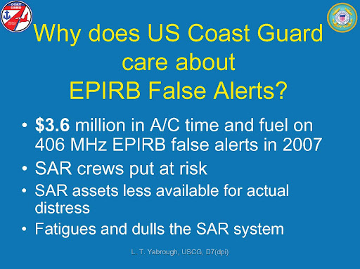
So Mr. Ellison let us help you out a little here at least on the false alarm issue...This is a new (United States Coast Guard Report) (pdf format), for you and your readers as well as our reader to review.... This report was very difficult to compile for the reasons we noted previously and our compliments to Captain Larry Yarbrough (USCG ret) for his diligence in not just taking the lead and preparing this report but recently briefing it to both his peers as well as the industry. It took seven months with three people in a painstaking process along with investigating the archives and interviewing folk to obtain this data. No small feat to say the least and in our opinion it is just the tip of the iceberg.

Yes we have a long way to go, much to do and learn to improve on a alert system that has proven itself extremely valuable to all mariners. Again this system has saved thousands of lives over the years and continues to play a critical life safety role and will for the foreseeable future, especially with the next generation of GPIRBs. But if we can reduce just part of these false alarms and understand what the failure rate truly is, why it occurs and even reduce those gaps ultimately saving additional lives. Then like we said, its a good fight to undertake. Regardless of the naysayers blowing smoke rather than assist to get to the root cause. We will continue this endeavor to bring to you all the facts no matter where they fall.

This is about improving an important life safety system, closing gaps in the system and saving more lives. Not defending or attacking manufacturers without cause and certainly not self promotions and duckspeak....

But lets not kid ourselves either, $3.6 Million dollars worth of taxpayers money as well as wasted Coast Guard resources went into chasing those false alarms as noted. This is not the way to do business in any ones book. It' should also not be he cost of doing business, in a business that is suppose to save lives. While we will never completely eliminate false alarms we can reduce them and that Mr. Ellison is a FACT! . This report raises many question that we believe need to be answered.

We will continue to update our readers not just as our EPIRB investigation continues.... But now as the NOAA/USCG/Sean Seamour II investigation gets underway.


Maritime Safety Committee (MSC), 84th session: 7-16 May 2008

IMO adopted a mandatory casualty investigation code and moved forward with the implementation of long-range identification and tracking (LRIT) of ships, when the Maritime Safety Committee (MSC) met in London, for its 84th session from 7 to 16 May.

New casualty investigation Code adopted
The MSC adopted a new Code of International Standards and Recommended Practices for a Safety Investigation into a Marine Casualty or Marine Incident (Casualty Investigation Code). Relevant amendments to SOLAS Chapter XI 1 were also adopted, to make parts I and II of the Code mandatory. Part III of the Code contains related guidance and explanatory material.

The Code will require a marine safety investigation to be conducted into every "very serious marine casualty", defined as a marine casualty involving the total loss of the ship or a death or severe damage to the environment.

The Code will also recommend an investigation into other marine casualties and incidents, by the flag State of a ship involved, if it is considered likely that it would provide information that could be used to prevent future accidents.

The new regulations expand on SOLAS Regulation I/21, which requires Administrations to undertake to conduct an investigation of any casualty occurring to any of its ships "when it judges that such an investigation may assist in determining what changes in the present regulations might be desirable".

Long Range Identification and Tracking
The MSC made a number of decisions to ensure the timely implementation of the LRIT system. SOLAS regulation V/19-1 on LRIT entered into force on 1 January 2008 and will apply to ships constructed on or after 31 December 2008 with a phased implementation schedule for ships constructed before 31 December 2008. The LRIT system is intended to be operational with respect to the transmission of LRIT information by ships from 30 December 2008.

The MSC adopted a resolution on the Establishment of the International LRIT Data Exchange on an interim basis, confirming that the International LRIT Data Exchange will be provided temporarily by the United States at their own expense and that a permanent solution should be found as soon as possible.

The MSC endorsed a financial model based on the "user pays" principle, agreeing that charges for the provision of LRIT information for the search and rescue of persons in distress at sea should, in all cases, be free of charge to the search and rescue service of the Contracting Government requesting such information.

The Committee adopted revised Performance Standards and functional requirements for the long-range identification and tracking of ships, to update previous versions, and agreed MSC.1 Circulars giving Guidance on the survey and certification of compliance of ships with the requirement to transmit LRIT information; Guidance on Search and Rescue Services in relation to requesting and receiving LRIT information; Guidance on the implementation of the LRIT system; and Interim revised Technical Specifications for the LRIT system.

The International Maritime Satellite Organization (IMSO), acting as LRIT Co-ordinator, will authorize the integration, on an interim basis, of the Data Centres that have undergone and satisfactorily completed developmental testing, into the production LRIT system.

Meanwhile, the ad hoc LRIT Group was authorized to consider and adopt amendments to technical specifications for the LRIT system on behalf of the Committee, during the period between MSC 84 and MSC 85 (meeting November-December 2008), and to develop, agree and adopt, the documentation for the testing and integration of the LRIT system. The Committee also instructed the ad hoc LRIT Group to consider and report to MSC 85 on all matters relating to the development of a plan for the continuity of service of the LRIT system and, if possible, to develop such a plan.

Amendments to SOLAS
The MSC adopted the following amendments to SOLAS chapters II 1, II 2, III, IV and XI 1. The amendments are expected to enter into force on 1 January 2010:


· amendments to SOLAS chapter II-2, regarding drainage of special category and ro-ro spaces to prevent accumulation of water on the vehicle deck of ro-ro ships;

· amendments to SOLAS Chapter XI 1 to add a new Regulation 6 (Additional requirements for the investigation of marine casualties and incidents) to make mandatory parts I and II of the new Casualty Investigation Code;

· a new SOLAS regulation II-1/3-9 (Means of embarkation on and disembarkation from ships), to require ships built after its adoption and entry into force to be provided with means of embarkation and disembarkation, such as gangways and accommodation ladders;

· A new SOLAS regulation and amendments to SOLAS regulation II-1/3-4 (Emergency towing arrangements on tankers), to extend the regulation to ships other than tankers. The MSC also approved Guidelines for owners/operators on preparing emergency towing procedures; and

· Amendments to regulations III/6, III/26 and IV/7 to replace requirements for "radar transponders" with a requirement for a "search and rescue locating device".

Amendments to 1988 SOLAS Protocol
The MSC adopted amendments to the 1988 SOLAS Protocol, to replace the reference to "radar transponders" with a reference to "search and rescue locating devices", in the form of safety certificate for passenger ships and forms of safety certificate for cargo ships.

Amendments to Guidelines on the enhanced programme of inspections during surveys of bulk carriers and oil tankers
The MSC adopted amendments to the Guidelines on the enhanced programme of inspections during surveys of bulk carriers and oil tankers (resolution A.744(18)) (ESP Guidelines), including a new part B on Survey guidelines for double skin bulk carriers applicable to bulk carriers of 500 gross tonnage and over having double-side skin construction.

Amendments to the International Maritime Dangerous Goods Code
The MSC adopted Amendment 34-08 to the International Maritime Dangerous Goods (IMDG) Code. The amendment includes changes to provisions for certain substances, including changes to requirements for documentation for dangerous goods in limited quantities. The amendments are expected to enter into force on 1 January 2010, but may be applied in whole or in part voluntarily from 1 January 2009.

Amendments to HSC Codes
Amendments to the International Codes of Safety for High-Speed Craft (1994 and 2000 HSC Codes) were adopted to bring them in line with SOLAS chapter III amendments on search and rescue locating devices.

Code of Safety for Special Purpose ships adopted
The MSC adopted a revised and updated Code of Safety for Special Purpose Ships (SPS Code), such as sail training ships, cable laying ships and research vessels. The original SPS Code was adopted in 1983. The 2008 version provides an international standard of safety for new special purpose ships that will result in a level of safety for the ships and their personnel equivalent to that required by SOLAS.

Piracy and armed robbery against ships
The MSC discussed the continued concern about increased incidents of piracy off the coast of Somalia and IMO Secretary-General Mr. Efthimios E. Mitropoulos requested Members of the UN Security Council (UNSC) to support a resolution currently being considered by the UNSC to address the issue and urged all other members to promote, through the United Nations General Assembly, action to prevent piracy off the coast of Somalia.

Meanwhile, the MSC noted that a two-stage, sub regional meeting on piracy and armed robbery against ships in the Western Indian Ocean was held in Dar es Salaam, United Republic of Tanzania from 14 to 18 April 2008. The meeting, attended by 13 States from the region, developed and agreed a draft Memorandum of Understanding concerning the suppression of piracy and armed robbery against ships in the Western Indian Ocean, the Gulf of Aden and the Red Sea, for onward transmission to national authorities and the Council of IMO, with a view to concluding the agreement later this year.

Review of guidelines for prevention and suppression of piracy and armed robbery
The MSC established a correspondence group to review MSC/Circ.622/Rev.1, Recommendations to Governments for preventing and suppressing piracy and armed robbery against ships; MSC/Circ.623/Rev.3 Guidance to shipowners and ship operators, shipmasters and crews on preventing and suppressing acts of piracy and armed robbery against ships; and resolution A.922(22), Code of Practice for the Investigation of the Crimes of Piracy and Armed Robbery Against Ships. An interim report is expected to be submitted to MSC 85, with a final report being submitted to MSC 86 in 2009.

Goal-based new ship construction standards
The MSC re-established the Working Group on Goal-based Standards (GBS) for New Ship Construction to progress the work on the issue, taking into account the reports of the Working Group on Goal-Based Standards at MSC 83; the interim progress report of the Pilot Panel; and the report of the Correspondence Group on Goal-Based Standards.

A work plan for the continued development of GBS was agreed, which would see MSC 85 finalizing and approving Tiers I to III of GBS for bulk carriers and oil tankers and finalizing and approving associated SOLAS amendments; and MSC 86, in 2009, finalizing generic guidelines for developing goal-based standards.

In the longer term, the work plan would include assessing the experience gained from the application of GBS; application of GBS to other ship types on an incremental basis; and expansion of GBS to cover every aspect of the design and construction of new ships.

Review of STCW Convention and Code
The Committee noted the progress of work relating to the comprehensive review of the STCW Convention and the STCW Code by the Sub-Committee on Standards of Training (STW) and agreed to invite the Council to endorse, in principle, the holding of a Diplomatic Conference in 2010 to adopt amendments emanating from the comprehensive review.

This, the first major review since the 1995 STCW Conference, is intended to ensure that the Convention, as it may be revised, meets and responds adequately to the present and future needs of the shipping industry.

Implementation of the revised STCW Convention
The list of Parties deemed to be giving full and complete effect to the provisions of the International Convention on Standards of Training, Certification and Watchkeeping for Seafarers (STCW), 1978, as amended, was updated when the Secretary-General submitted his report on those countries which had communicated information pursuant to STCW regulation I/7, or reports pursuant to STCW regulation I/8, and whose evaluations had been completed since the previous MSC meeting.

The MSC approved the revised list of confirmed Parties to the STCW convention, which now includes 119 Parties.

Amendments to International Safety Management (ISM) Code approved
Following consideration by the Joint MSC/MEPC Working Group on Human Element, the MSC approved draft amendments to the International Safety Management (ISM) Code, to harmonize the requirement for the extension of the validity of the Safety Management Certificate (SMC) with those of SOLAS certificates and the International Ship Security Certificate (ISSC). The amendments will be submitted for adoption at the next session.

The MSC also prepared a preliminary draft text of amendments to the Revised Guidelines on Implementation of the International Safety Management (ISM) Code by Administrations.

Near-miss reporting
Following consideration by the Joint MSC/MEPC Working Group on Human Element, the MSC approved a draft MSC MEPC.7/Circular on Guidance on near-miss reporting, subject to a concurrent decision by MEPC 58 (meeting in October 2008).

The circular encourages reporting of near-misses so that remedial measures can be taken to avoid recurrences; and gives guidance on the implementation of near-miss reporting. The circular notes that companies should investigate near-misses as a regulatory requirement under the "Hazardous Occurrences" part of the ISM Code.

Work programmes of the sub-committees
The Committee took a series of decisions regarding the work programmes of the Sub Committees and, in particular, the inclusion of an item on the development of an agreement on the implementation of the 1993 Torremolinos Protocol in the work programme of the SLF Sub Committee and an item on the development of a Code for recognized organizations in the work programme of the FSI Sub Committee.


RS


Wednesday, June 4, 2008

A Global Map of Human Impacts to Marine

A Global Map of Human Impacts to Marine Ecosystems

Why map the human impact to the world's oceans?

What happens in the vast stretches of the world's oceans - both wondrous and worrisome - has too often been out of sight, out of mind.

The sea represents the last major scientific frontier on planet earth - a place where expeditions continue to discover not only new species, but even new phyla. The role of these species in the ecosystem, where they sit in the tree of life, and how they respond to environmental changes really do constitute mysteries of the deep. Despite technological advances that now allow people to access, exploit or affect nearly all parts of the ocean, we still understand very little of the ocean's biodiversity and how it is changing under our influence.

The goal of the research presented here is to estimate and visualize, for the first time, the global impact humans are having on the ocean's ecosystems.

Our analysis, published in Science, February 15, 2008 (no subscription required), shows that over 40% of the world's oceans are heavily affected by human activities and few if any areas remain untouched.

How did we create this map?


There were 4 steps to creating this composite map.

1. We gathered or created maps (with global coverage) of all types of human activities that directly or indirectly have an impact on the ecological communities in the ocean's ecosystems. In total, we used maps for 17 different activities in categories like fishing, climate change, and pollution. We also gathered maps for 14 distinct marine ecosystems and modeled the distribution of 6 others.

2. To estimate the ecological consequences of these activities, we created an approach to quantify the vulnerability of different marine ecosystems (e.g., mangroves, coral reefs, or seamounts) to each of these activities, published in Conservation Biology, October 2007. For example, fertilizer runoff has been shown to have a large effect on coral reefs but a much smaller one on kelp forests.

3. We then created the cumulative impact map by overlaying the 17 threat maps onto the ecosystems, and using the vulnerability scores to translate the threats into a metric of ecological impact.

4. Finally, using global estimates of the condition of marine ecosystems from previous studies, we were able to ground-truth their impact scores.

To learn more about the methods used in this study, see the Supplementary Online Materials in Science.

What does the map tell us?


First, we can compare different locations to determine the least and most impacted regions of the globe.

There are large extents of heavily impacted ocean in the North Sea, the South and East China Seas, and the Bering Sea. Much of the coastal area of Europe, North America, the Caribbean, China and Southeast Asia are also heavily impacted.

The least impacted areas are largely near the poles, but also appear along the north coast of Australia, and small, scattered locations along the coasts of South America, Africa, Indonesia and in the tropical Pacific.


For additional videos of the model and information on the SST data, please visit the National Oceanographic Data Center.

Second, the data summarized in the map provides critical information for evaluating where certain activities can continue with little effect on the oceans, where other activities might need to be stopped or moved to less sensitive areas, and where to focus efforts on protecting the last pristine areas. As management and conservation of the oceans turns toward marine protected areas (MPAs), ecosystem-based management (EBM) and ocean zoning to manage human influence, we hope our study will be useful to managers, conservation groups and policymakers.

WEATHER NOTE

New storms rake Central Indiana

Tornadoes hit Rush, Johnson counties

By Kevin O'Neal and Heather Gillers
kevin.oneal@indystar.com

As residents of the Falcon Point apartments sift through the remains of their homes today and representatives of the Federal Emergency Management Agency arrive to examine the damage from last week's storm, Hoosiers in other parts of the state are likely waking up to new weather carnage.

A succession of storms marched through the state late Tuesday, spawning at least three tornadoes.

The National Weather Service tracked two tornadoes on the ground south of Indianapolis that triggered significant damage reports Tuesday night.

One was initially reported near St. Paul on the Rush-Decatur line, where damage to utility poles was reported and wires were torn down.

Weather service meteorologist Joseph Nield said the same tornado apparently hit the village of Moscow in southern Rush County, where injuries were reported and some people were said to be missing.

Sheriff's deputies were going door to door in the Moscow area to check on residents, said Lt. Ceilia Nigh, a department dispatcher. READ>

Tornado deaths in cars spurs improved warnings

WICHITA, Kan. (AP) -- It's turning out to be a deadly year for tornadoes, especially for drivers caught in a storm's path.

The deaths last month of a Colorado couple whose car was tossed more than 100 yards from a southwest Kansas highway brought the state's total of people killed by twisters while in their vehicle to three in the last 11 months.

That has the Kansas Department of Transportation looking for more effective ways to warn drivers of severe weather and how they should take proper precautions.

While signs near toll booths on the Kansas Turnpike tell drivers to tune into 1610-AM for travel advisories, similar signs aren't posted along the other major east-west corridors of Interstate 70 and U.S. 54.

"We're really trying to hash out what we should put up," said department spokesman Tom Hein. "These storms have encouraged us to look at that and try to find a solution."

Nationally, the number of people killed by tornadoes while in their vehicles -- 14 as of Wednesday -- is the highest annual total since 1998, according to the National Oceanic and Atmospheric Administration's Storm Prediction Center.

A big share of those deaths came on May 10, when tornadoes in Oklahoma and southeast Missouri killed eight people in their cars.

Experts say there is a wealth of technological improvements to help drivers stay on top of severe weather but they must also rely on their own judgment.

"If it doesn't look right, don't drive into it," said Chance Hayes, warning coordination meteorologist for the National Weather Service in Wichita.

Drivers don't always listen to such advice as storm trackers documented as a series of tornadoes barreled through northwest Kansas on May 23. As their cameras recorded clouds churning the dust, vehicles could be seen leisurely driving nearby. READ>

Storms pummel portions of Illinois UNDATED - Parts of Illinois are cleaning up and drying out after storms raked much of the region, flooding some roads and downing trees and power lines.

The National Weather Service says central Illinois got more than three inches of rainfall on Tuesday, notably around Springfield and Decatur.

In Champaign and Urbana, heavy rain led to minor flooding in the basements of some University of Illinois buildings and the studio of WCIA-TV in Champaign.

Winds knocked down power poles along U.S. 67 near Industry, Illinois, about 55 southwest of Peoria. Illinois State Police say the highway was closed. READ>

Organization says government not ready for disaster
By Eloria Newell James, community@leadercall.com

With Hurricane Season beginning today, a watchdog group is highlighting some concerns they say indicate the government is not fully prepared for a natural disaster.

Citing minimum changes in the Federal Emergency Management Agency’s Program, a still strained military presence with the National Guard and heavy dependence on volunteers as concerns, Ben Smilowitz, founder and executive director of the Disaster Accountability Project, said more needs to be done by the government

Smilowitz said there are gaps in the services available to victims of natural disasters.

“Despite recent assurances from leadership at the U.S. Department of Homeland Security (DHS) and FEMA that the Federal government is prepared for a major disaster, significant areas of concern remain that must be resolved before the U.S. disaster management system can honestly represent itself as sufficiently prepared to respond to a disaster requiring federal resources,” Smilowitz said. “Right now our nation has a volunteer force set up to offer victims of natural disasters help. ... I don’t feel that a volunteer force can provide the caliber of care needed after a disaster.” READ>

MARITIME NOTE

Stricken ferry's cargo removed

The stricken ferry Riverdance, which ran aground near Blackpool, has now had all its cargo and trailers removed.

Work on removing its stern, bow and the port side ballast tanks will take place over the next 10 days.

A Maritime and Coastguard Agency spokesman said: "Very good progress has been achieved to date and the overall project remains on schedule."

UK – Riverdance update

The UK Maritime and Coastguard Agency (MCA) issued a press notice stating that significant progress is being made on the dismantling of the ro-ro ferry RIVERDANCE that grounded near Blackpool. (5/30/08).

Arctic countries unprepared for cruise ship accidents: officials

As more cruise liners travel in Arctic waters, fuelled by tourists' interest in the North and made possible by shrinking sea ice, U.S. and Canadian officials are questioning their abilities, as well as those of other Arctic nations, to handle cruise ship accidents.

Speaking at last week's Canadian Arctic Summit in Edmonton, a representative from the U.S. Coast Guard said it doesn't have the resources to respond quickly to a massive rescue operation in the northern Bering Sea and the Arctic waters off Alaska.

"Some things we're looking at is: how much icebreaker time we need up there? Do we put other vessels up there? How much [is] the aircraft response time?" Capt. Michael Inman, the coast guard's chief of response in Juneau, said at the summit.

"All those things we're looking at, we're not at the end point where we know what we're going to have to put there."

Inman said seven cruise ships carrying over 3,000 passengers will be heading to the northern Bering Sea and waters off Alaska this year.

Meanwhile, Inman said, more than 70 cruise ships will travel to Greenland this year, carrying more than 150,000 passengers.

"How do we work in this region in an expanded role in the future? And what are the best ways to actually provide the services required by law?" he said. "We're still looking at that."

U.S. officials said there were 28 North Pole transits by icebreakers between 2004 and 2007, along with the largest number of ships ever in the Barents Sea.

That amount of ship and icebreaker traffic is of concern to Mary Williams, director general of the National Research Council of Canada's Institute for Ocean Technology. READ>

RS