Friday, January 25, 2008

Waterspouts and Ships!

Waterspouts are one of the subjects that we have yet covered.

So since I received the below email from a good friend of mine, who is serving as a Chief Mate aboard a "Drill Ship" doing exploration off the coast of South America. (No the report did not come from this vessel I linked to either).

So what is a Chief Mate aboard a commercial ship? Well he is next in command to the Master or Captain. For you Star Trek fans this would be equivalent to Mr. Spock...

So I thought we would visit the subject. Remember when aboard ship there is really no place to run!

(To the left is a drawing by Benjamin Franklin and his understanding of water spouts.

Benjamin Franklin was a student of severe weather and theorized about how storms formed. Representation of waterspout accompanying "Water-spouts and Whirlwinds" by Benjamin Franklin.

This paper was republished in "The complete works in philosophy, politics, and morals, of the late Dr. Benjamin Franklin ....", 1806. Volume II, p. 26. Library Call Number PS745 .A2 1806. Image ID: wea00342, Historic NWS Collection)

As my shipmate writes....

"At around 9:45 on Wednesday 16 Jan we were drilling and sitting in 40knot winds from direction 145... A ABS (Able Body Seaman) ran into the operations office and said he spotted a waterspout. Operations opened the door and said there was zero visibility. A couple minutes later we got hit with a steady 85 knots on the stbd beam, gust up to who knows what. All 6 7,000hp thrusters kicked in but we were still pushed off 35 feet."

Its not all that uncommon for ships to get struck by a waterspout since its really hard to sail around them and especially when watches and warning at sea are almost non-existent. Yes the ship will get weather briefs or weather faxes with potential dangers, but unlike a shore-based tornadoes there is no news flashes, warning sirens, news helicopters daring the twister or storm chasers and spotters sounding the alert. As he writes, most of these events are spotted by the crew and by that time ... well... as you can read it is sometimes too late.

In this case there was no injuries and damage was very limited. But as you can read this water spout actually move the ship off station by 35 feet. Now that might not sound like a lot but on many ships and especially offshore platforms like a drill ship, have a computer control system called a "Dynamic Positioning System" which keeps the ship stabilized and on course or on station. Its like a very advanced cruise control for ships.

Though there were two reported, now funny events (they were not at the time). Seems as the waterspout dropped in for a visit there was one seaman at the time working on the derrick of this drill ship and supposedly you now can see his finger nail marks on the hand rails! One lucky dude! The second one though some of you might laugh, but seafarers do take superstition seriously even today. It involved a visiting technical representative who came onto the bridge whistling just prior to the ship being struck by the waterspout. This person was asked to stop whistling and replied something to the effect that they were not superstitious.

Well you see, according to maritime lore, whistling "on-board" ship brings winds... Moments later the ship was struck by the waterspout along with 85 knots+ winds....Think that person is now superstitious?

So what is a "Waterspout"?

Waterspouts are tornadoes over water. But scientific work over the last 30 or so years has led to a more complicated picture with waterspouts differing in some ways from tornadoes over land, especially large ones.

Waterspouts and all the different kinds of tornadoes have a similar basic structure with air moving upward. At the ground or ocean surface, winds are rushing faster and faster as they swirl into the vortex and then upward.

Often with both tornadoes and waterspouts, the vortex is seen coming down from the cloud, but not obviously touching the ground or ocean. Such vortices that don't seem to touch the ground are called "funnels" or "funnel clouds."

It's important to say "seems" not to touch because often, especially in the beginning, the vortex is invisible along part of its path. We begin to see the vortex when its lower air pressure cools the air enough to condense water vapor in the air into tiny water droplets.

Beginning in the late 1960s when he investigated waterspouts in the Keys from a single-engine Cessna 172 piloted by a friend, Joseph Golden, now a senior scientist at the National Oceanic and Atmospheric Administration, documented the "what" of spouts and tried to puzzle out the "why." The original studies were for his Ph.D. thesis at Florida State University.

During 12 days in September 1974, Golden flew into 16 Florida Keys waterspouts — one of them 26 times — in a North American T-6 airplane that had been modified for weather research. The World War II era trainer was flown by a professional weather research pilot. Golden recalls that flying into spouts with winds blowing faster than 60 mph around the vortex and moving upwards at 20 mph or better "rattled my teeth."

And, he notes, these were "weak to moderate" strength waterspouts. Careful study of movies or videos of waterspouts show speeds up to the 190 mph range.

They are not to be taken lightly.

In fact, Golden speculates that "a significant fraction of the so-called Bermuda Triangle incidents are from waterspouts."

How waterspouts form

The first sign, which can be seen from the air but usually not from a boat, is the formation of a dark spot on the ocean. Smoke flares dropped in these areas show the air is moving in a circle and upward. Many dark spots die out without progressing any further. But some begin to take on a spiral pattern of dark and lighter water.

Golden says at this second stage someone on a boat at the surface would probably feel the wind shift and maybe increase. Also, if you looked upward, you might see a funnel coming from a cloud overhead or off to one side.

People on boats will see the third stage.

Even though it might be invisible, a vortex is reaching the ocean surface from the cloud. When the wind speeds reach around 40 mph, the wind begins to kick up spray in a circular pattern — the spray vortex. At this time you might see the funnel pointing down from the cloud toward the ring.

The fourth, or mature, stage is when the funnel reaches all the way from the cloud to the ocean. You can usually see through the funnel - it's really a thin cloud of tiny water droplets.

During this stage, small waves are being kicked up and the spout leaves a bubbly wake behind as it moves across the ocean. These tiny bubbles could be carbon dioxide and other gases that are dissolved in the water that are caused to effervesce by the low air pressure in the spout's center - like a bottle of soda that's just opened.

In the fifth, and final stage, the spray vortex weakens and the funnel becomes shorter and maybe more tapered. It often twists around and the bottom of the waterspout may move out from under the cloud.

Scientists say the waterspout's dissipation usually occurs when rain begins falling from the parent cloud. Cool air brought down by the rain cuts off the supply of warm, humid air that's feeding into the waterspout to keep it going.

Where waterspouts are most likely

The Florida Keys "are the greatest, natural vortex lab in the world," says Golden. "Waterspouts probably occur more frequently in the Florida Keys than anywhere in the world."

Waters around the Keys, especially from Marathon past Key West on westward to the Dry Tortugas, probably see 400 or 500 waterspouts a year. Since they are so common, most go unreported unless they cause damage.

Golden suspects so many waterspouts hit the Florida Keys because the weather and geography supply two necessary ingredients.

First, the islands and the shallow water along them help heat the air. During the summer, waterspout season, the air is extremely humid with temperatures in the mid-80s into the low 90s. The heat causes the air to rise. As it rises, the air's humidity condenses into the tiny water droplets that make up clouds.

As water vapor condenses, it releases more heat that makes the air rise even faster. Rising air currents are needed for waterspout formation.

The second important waterspout ingredient in the Keys seems to be the regular east or northeast "trade winds" that blow right down the islands. These winds help line up the clouds. Lines of clouds encourage waterspouts. Exactly how is one of the questions researchers are trying to answer.

Clouds that spawn waterspouts in the Keys are generally from around to 18,000 to 22,000 feet high. Golden says, waterspouts are likely to form when the clouds are growing upwards.

In the Keys, waterspouts are most likely to form between 4 and 7 p.m. with a secondary maximum from 11 a.m. to 1 p.m. A few waterspouts form around sunrise.

After the Florida Keys, the next most active U.S. waterspout area is the southeast Florida Coast from around Stuart south to Homestead. Tampa Bay has the greatest number of damaging waterspouts, probably because the shores of the Bay are so built up.

Places around the Gulf of Mexico along with the Atlantic Coast northward to Chesapeake Bay are also likely to see waterspouts. Waterspouts have been reported on the West Coast from Tatoosh Island, Wash., south to San Diego, but they tend to be weak and short lived. Waterspouts also skip across the Great Lakes and Utah's Great Salt Lake from time to time.

Boaters safety around waterspouts

Even though waterspouts are usually weaker than the strong tornadoes over land, they can be a real danger to boaters. Waterspouts are most common in the Florida Keys and over other warm oceans, but they can occur over just about any body of water.

As with any kind of weather hazard, safety begins by staying informed. One of the special radios that pick up weather broadcasts should always be aboard your boat. And, you should listen to it regularly.

Waterspouts tend to come from clouds with a dark, flat bottom when there is just the first hint of rain.

If one heads your way, try to escape by going at right angles to its path. And if it's about to hit your boat, the best bet might be to dive overboard. Flying debris is the big killer in tornadoes and waterspouts.

How about diving underwater to escape?

"If you dive before one hits, I think you will be O.K.," says Golden.

But no one really knows what the water is doing right under a waterspout and such a dive should be a last-ditch attempt to avoid flying debris. I'm not prepared to say it's safe to dive under a waterspout," Golden says. Source: USA Today

Here is a pix of one getting ready to drop in for a visit!

water spout

Source NOAA

WATERSPOUTS THREAT TO SHIPPING ?

In the summer of 1949, a message was broadcast describing an exotic natural phenomenon. On a coastal region of New Zealand, a rain shower was accompanied by the fall of thousands of small-sized fish. A similar occurrence was observed in 1933 by the inhabitants of village of Kavalerovo in Primor'ye Territory, but instead of fish, there was a rain of jellyfish.

In August, 1972, a giant waterspout appeared near the town of Khosta (Black Sea coast). Darkness covered the town. On the coast of Tikhaya Bay, a waterspout dropped a huge mass of water (about 150,000 tons).

In historical chronicles, there are many authentic stories about similar kinds of unusual rains. The cause of these rains is often waterspouts, the diameter of which range from several tens of meters up to 3 km, with an average height of 800 - 1,500 m, and on occasion, 2 - 3 km. The wind-speed inside a waterspout reaches 100 m/s. The vortices move with a speed of 5 - 10 m/s and sometimes, up to 30 m/s. The duration of the “life” of waterspouts is from several minutes to several hours. During this time, they can travel hundreds kilometres, destroying everything in their paths.

For a long time, the nature of waterspouts remained a riddle. It has now been found that waterspouts occur when air masses spin rapidly during thunder-storms in areas where the air-flow has a sharply distinguished speed of movement, temperature and water vapour content.

When a storm-cloud passes, there are sharp changes in the wind direction and speed and also differences in the air temperature in the most intense section. Unevenly heated air masses have different densities and collisions occur, causing a spinning motion. The rotation rate increases, and a waterspout is born. When air rotates in a vortex, centrifugal forces are generated. The air pressure inside the tube of a waterspout is sharply reduced, and the difference between this pressure and the outer edge may be as much as 200 mbar. Because of this air-pressure difference, there is almost no cooling taking place, resulting in condensation of the water vapour always present inside of the tube.

A waterspout has a cloudy tube descending to the sea-surface. The sharp decrease in air-pressure inside the tube of a waterspout also explains why suction occurs when one is present. For this reason, as soon as the tube of a waterspout breaks contact with the sea-surface, all of the water being carried is dumped, falling to earth. A waterspout is capable of lifting and carrying particles of sand, water, stones, live sea creatures, and sometimes, people, roofs of houses, etc. All of these can be carried long distances. Waterspouts often cause some destruction at coastal beaches, frequently killing people. If a vessel at sea encounters a waterspout, it is a dangerous situation. Source: UN Atlas of the Oceans

(Jesse Ferrell) of The WeatherMatrix Blog. Has a excellent post with pix's on the End-of-Year Waterspouts for Florida.

NWS Key West Florida has a good page for spout pix's...

NWS Gaylord Michigan has a excellent write up on spouts in the Great Lakes

Storm Chaser Steve Sponsler sent me these videos of a spout taking a whack at some ships at anchorage on May 26, 2007.


SISTERS! JUNE 11, 2007


SISTERS NOT GOOD ENOUGH? MARCH 30, 2007


LASTLY MARITIME NOTES:

January 24, 2008
Ships Collide in Newark Bay and Fluid Leaks
WNBC 4HD NYC

Shortly before 2 this afternoon, three ships collided in Newark Bay, closing the bay to marine traffic.

The three-way collision was between two dredging vessels, the 117-foot Melvin Lemmerhirt and the New York, and the 669-Foot Liberian tanker Orange Sun. The Orange Sun is reported to be carrying orange juice as its cargo. Reports also say the New York is taking on water, that there is a fluid leaking from one of the ships (presumably, not orange juice), and there's hydraulic fluid leaving a sheen on the waters nearby. The juice-filled Orange Sun is being brought back to harbor via tugboat.

Newark Bay is about six miles long and one mile wide and is a tidal back bay of New York Harbor. It's bound by the shores of Newark and Elizabeth on the west, Jersey City on the east and Staten Island on its south. Port Newark-Elizabeth, which is in Newark Bay, is the main port of entry for the New York area.

Ice Prince Update Ice Prince Update

Latest information on the Greek-registered cargo vessel that sank last week.


MSC Napoli: A Year Late
Nearly a year after the MSC Napoli first ran into trouble, the first phase of removing its stern has been completed.

JANUARY 24, 2008 CALIFORNIA SPOUT/TORNADO UPDATE

A rare tornado has touched down in Southern California. It started as a waterspout last night (24 JANUARY) in the Pacific and came ashore at the Point Mugu (muh-GOO') Naval Air Station up the coast from Malibu, ripping a roof off a hangar. It scattered debris on a tarmac but nobody was hurt and flight operations were not affected. The small tornado was from a much bigger storm system that's been causing problems in Southern California, pounding the region with heavy rain and deep snow and triggering at least two tornado warnings last night. Hundreds of cars and tractor trailers had been left stranded on a major highway north of Los Angeles. One driver says he was stuck on the road for 24 hours.


Chicago Weather? Clear, with a low around -1. Wind chill values as low as -12. West wind between 5 and 10 mph.


Forget cold.... Cold was in November....
This will be a good weekend to stay home and do some honey do's......like dusting!

Have a great....brrrrr ...warm weekend!


RS
PS: Thanks Steve....

Thursday, January 24, 2008

The Oceans Have Their Own Weather Systems

Pioneering expeditions investigate how eddies make life bloom in oceanic deserts

In the 87 days that Dennis McGillicuddy and colleagues spent in the Sargasso Sea in the summer of 2005, they were tossed around or chased by four hurricanes and two tropical storms: Franklin, Harvey, Irene, Maria, Nate, and Ophelia.

Not one of those massive storms was as powerful as the one swirling in the water beneath them.

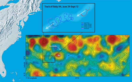
From June to September, McGillicuddy and a team of more than 20 scientists from Woods Hole Oceanographic Institution and five other marine science labs tracked an eddy named A4. It was the oceanic equivalent of a hurricane—a huge mass of water spinning like a whirlpool, moving through the ocean for months, stretching across more than 62 miles (100 kilometers), stirring up a vortex of water and material from the depths to the surface.

“Eddies are the internal weather of the sea,” says McGillicuddy, an associate scientist in the WHOI Applied Ocean Physics and Engineering Department. But unlike destructive hurricanes, eddies can be productive. As certain types of eddies stir the ocean, they draw nutrients up from the deep, fertilizing the waters to create blooms of microscopic marine plants in the open ocean, where little life was once thought to exist.

“The open ocean is twice as productive as we can explain based on what we know about nutrients in the water,” said McGillicuddy. “Where do all the nutrients come from to make these oases in the oceanic desert?”

Pump up the volume (of nutrients)
The Sargasso Sea—south and east of the Gulf Stream—forms the geographic center of the North Atlantic Ocean. It is warmer, saltier, bluer, and clearer than most other parts of the North Atlantic, except for the floating mats of
sargassum seaweed that gave the sea its name. For centuries, prevailing wisdom was that such open ocean waters were mostly desert-like, unproductive regions.

A lecture on the Sargasso Sea in the early 1990s sparked McGillicuddy’s curiosity. In the talk, Bill Jenkins, a senior scientist in the WHOI Marine Chemistry and Geochemistry Department, pointed out that scientists were finding more oxygen being produced and consumed in the open ocean than anyone expected. The suspects were phytoplankton, microscopic marine plants that produce oxygen in photosynthesis, and zooplankton (microscopic animals) and bacteria, which use oxygen as they consume plants and organic detritus that sink to the seafloor.

Scientists found 10 times more microscopic life in the Sargasso Sea than anyone could explain, given the dearth of nitrate, phosphate, trace metals, and other nutrients that plants need to grow in sunlit surface waters. Researchers slowly developed the hypothesis that vortices of cold or warm water—eddies—might somehow act as a biological pump.

“I had proposed a problem, and Dennis suggested a solution,” Jenkins said. “He had the clever idea that eddies were perturbing the layers of the water column, mixing different waters, and bringing nutrients up from below.” The upwelling of nutrients into the euphotic zone (the top 330 feet or 100 meters of the ocean, where light penetrates) would stimulate prodigious blooms of phytoplankton, which attract zooplankton and other animals up the food chain.

The Eddies Dynamics, Mixing, Export, and Species composition (EDDIES) project was born.

Into the eye of the oceanic storm
“Dennis has wanted to do this experiment since he was a graduate student,” said Dave Siegel, a longtime collaborator with McGillicuddy and an oceanographer from the University of California, Santa Barbara (UCSB).

McGillicuddy mustered chemists, biologists, and physical oceanographers from WHOI, UCSB, Rutgers University, Bermuda Biological Station for Research (BBSR), Virginia Institute of Marine Sciences, Dalhousie University, and the University of Miami. Together, they secured $3.5 million from the National Science Foundation, as well as five months of ship time over two years on the WHOI-operated research vessel
Oceanus and the BBSR-operated Weatherbird II.

The goal: to make detailed chemical, biological, and oceanographic measurements of a specific eddy by getting right into the middle of it.

“We didn’t want to just sit on the fence and watch from one point,” said Ken Buesseler, chairman of the WHOI Department of Marine Chemistry and Geochemistry. “Eddies move and develop, so we decided to follow a parcel of ocean as it moved. This was the first time anyone has really studied an eddy in this way.”

Toward a holistic view of scientific problems
Eddies are distinct parcels of water that move and jostle within the ocean, much like warm and cold air masses or high- and low-pressure systems in the atmosphere. Eddies are formed by differences in ocean temperature and salinity that give water different densities. Like oil and water, water masses of different densities tend to keep separate, rather than mix.

The largest eddies can contain up to 1,200 cubic miles (5,000 cubic kilometers) of water and can last for months to a year. Earth’s rotation—the Coriolis force—gives eddies their spin.

To hunt for their target, McGillicuddy and colleagues used data from satellites, whose measurements of sea surface heights show telltale signs of eddies. Warm-water eddies form bumps in the ocean; cold-water eddies form depressions. The team examined several eddies and settled on anticyclone No. 4, or A4, a “mode water” eddy (see "The Hunt for 18° Water") that stretched some 93 miles (150 kilometers) in diameter at the surface.

The EDDIES program took a truly integrated approach, combining many tools—satellites, ships, moorings, drifters, robotic vehicles, computer models—and many types of scientists.

From June 20 to Sept. 14, 2005, the researchers zigzagged across the eddy as it drifted southwest about 3.7 miles (6 kilometers) per day. The team on
Oceanus buzzed around collecting water and nutrient samples, measuring current speeds and directions, and towing WHOI biologist Cabell Davis’ Video Plankton Recorder through the turbulent swirl. Bill Jenkins and his lab mates measured natural chemical markers such as tritium, an indicator of the amount of plant-fueling nitrate being raised from the depths. WHOI Senior Scientist Jim Ledwell, an expert on using tracers in the ocean, injected sulfur hexafluoride, a harmless chemical, into the middle of the eddy and tracked how it spread up, down, and across the sea.

At the same time, a research team on
Weatherbird II made targeted measurements in the core of the eddy, measuring plant and animal productivity, the movement of particles, and thorium, a radioisotope that marks how much organic material is sinking from surface waters. Siegel used a radiometer to measure whether the eddy was disturbing the light penetrating the blue water.

“Ocean scientists are moving toward a more holistic view of their research problems,” said Siegel. “Ocean science grows by filling in the cracks between disciplines. If you put a smart and diverse group of people together in a boat, a lot of good things can happen. People start to think outside of their own little research worlds, and together we can tell scientific stories that we couldn’t put together individually.”

Stirring up a rich soup

Fueled by nutrients from the deep, diatoms bloomed to concentrations 10,000 to 100,000 times the norm—among the highest ever observed in the Sargasso Sea.

At the same time, the team was surprised to find historically low concentrations of oxygen in the depths, a sign of zooplankton and bacterial population explosions. It also meant that an awful lot of heat-trapping carbon dioxide may have been drawn out of the atmosphere and ocean surface, transformed by phytoplankton, and sunk to the bottom of the ocean.

Six months after the last EDDIES researcher stepped off
Oceanus, the scientists are still assessing and analyzing the wealth of data they collected on A4. The team met in February 2006 at the international Ocean Sciences Meeting in Hawaii to share observations and collectively make sense of what they saw. Ultimately, the goal is to develop high-resolution computer models—McGillicuddy’s specialty—that can simulate and predict the full range of eddy dynamics.

The EDDIES project is a critical step toward comprehending these great ocean storms, whose sheer size and scale are daunting. During the expedition, tropical storm Harvey made a direct hit in early August, cutting a path right across eddy A4. The eddy hardly felt Harvey; the monstrous atmospheric storm never came come close to breaking up the potent, voluminous swirl of water in the ocean.


—Mike Carlowicz


The EDDIES project received funding from the Chemical Oceanography, Biological Oceanography, and Physical Oceanography branches of the National Science Foundation.


WEATHER STORY

One of the severe weather issues that face the Great Lakes Region is severe Ice Jam flooding. So what are Ice Jam Floods? As NWS (LOT) Chicago explains....

Ice Jam Flooding

Wilmington ice jam 2007
Kankakee River Ice Jam at I-55 Feb 2007

Ice jams are resulting in flooding on some rivers in northern Illinois. The National Weather Service advises that if you come upon a flooded roadway, turn around, don’t drown! Also, do not attempt to drive around barricades placed at flooded roads. It only takes as little as 2 feet of flowing water to float many vehicles. More than half of all flood-related fatalities are a result of individuals attempting to drive through a flooded roadway.

What is an ice jam?
An ice jam is a stationary accumulation of ice that restricts flow. Ice jams can cause considerable increases in upstream water levels, while at the same time downstream water levels may drop, exposing water intakes for power plants or municipal water supplies. Types of ice jams include freezeup jams, made primarily of frazil ice; breakup jams, made primarily of fragmented ice pieces; and combinations of both.

Why are we experiencing so much ice jam flooding at this time?
Earlier this month, northern Illinois experienced warm temperatures that melted the existing snow in combination with heavy rainfall that resulted in near record flooding on some streams. Although water levels have receded since the near record levels, they remain well above normal for this time of year. These higher than normal flows are resulting in more substantial flooding when an ice jam forms.

Can you predict ice jams?
The National Weather Service monitors river levels at select gages on area streams, maintained and operated by the U.S. Geological Survey
. However, ice jams can be very localized and the gage reading may not always reflect what is happening a few miles upstream or downstream from the gage. In addition, jams can form and break with little or no warning making ice jams very difficult to predict.

If you live along streams prone to ice jams you should continue to closely monitor river levels and listen for possible flood statements or warnings. When a jam forms, water can rise many feet in minutes versus hours and days in a normal river flood, and you may have little time to take action. Report ice jams and ice jam flooding to local authorities for relay to the National Weather Service.


MARITIME NOTES

m/v Kapitan Uskov disappeared in East China sea - 1/24/2008 02:41
January 24, 01.15 LT – message from Germes Co., Sovgavan port (vessel’s operator) – dry cargo Kapitan Uskov disappeared in approximately 31.40N 125.58E area, East China sea, last communication was at 03.00 January 20, didn’t arrive at port of destination ETA January 24. All vessels in area requested to keep a sharp lookout and assist if possible. Japan S&R sendind a plane, Shanghai S&R also informed, asked to assist.m/v Kapitan Uskov (ex-Fine) IMO 8203830, dwt 5223, built 1982 Japan, flag Cambodia, owner ALAZARA NAVIGATION S.A, cargo 4523 rolled steel, crew 17 – all russian citizen.Weather 2-meters sea, wind NNE 20 knots.

NOAA – new Director of Office of Response and Restoration

The National Oceanic and Atmospheric Administration (NOAA) issued a news release stating that Mr. David Westerholm has been appointed as the new Director of the Office of Response and Restoration. (1/22/08).


READERS COMMENTS - CAPTAIN DUNSEL

Believe it or not I do sometimes get comments to my blog. Most are complimentary and many times informative and some even corrective. Then again I also get comments posted anonymously or without return emails and even possibly with stage names. I love these the most. They are always critical. Most of the times I just chuckle and hit the delete button since I view these as "coward postings". If one is going to bother to post to any ones blog or story at least have the common decency for the blogger or author to return a answer. But I guess its just human nature to be a "Captain Dunsel" once and a while...

Moreover if I make a mistake and its pointed out I normally thank the commenter and post the correction after the mistake has been vetted, (IF) the commenter has done so constructively. But in Mr. Paul Williams case (if that is his or hers real name) this "Captain Dunsel" posting deserves a reply on my blog.

Mr. Paul Williams writes,

"Paul Williams has left a new comment on your post The M/V Aratere Incident"

The video fottage attached to this story is of one of the Strait Shipping vessels, NOT an Interislander vessel and certainly NOT the Aratere. If you're going to post these sorts of messages and attach video footage then at least get it right. The interislander vessels are consideralbly larger than the Strait Shipping vessels, so this video is very misleading."

Mr. or Mrs. Williams here is referring to my
posting of Tuesday, August 28, 2007 on The M/V Aratere Incident and my posting of Friday, June 8, 2007 Another Plane Of View. Where I posted a picture of the M/V Aratere instead of one of Strait Bluebridge Ferry Service Passenger Ferries the Suilven. Well Mr. Paul (Captain Dunsel) Williams, many of us once and a while do make the wrong ship identifications. We all make mistakes. And after reviewing the video (fottage) footage I did in fact ID the vessel as Straits Suilven. You were correct. You get a cookie for this.

But lets talk about the rest of Captain Dunsel's posting and ship particulars here while missing the entire point. Captain Dunsel says "
The interislander vessels are "consideralbly" larger than the Strait Shipping vessels". The Suilvan came out of service in 2003. So we can only gauge Straits (Santa Regina or the Monte Stello) against the Aratere. The M/V Aratere's length is 150m or 492ft, has a beam of 20.25m or 66ft and its Gross Tonnage is 12,300. The Santa Regina has a length of 137m or 449ft with a beam of 22.5m or 73ft with a Gross Tonnage of 14,588. The Monte Stello has a Length of 126.5m or 415ft with a beam of 21m or 68ft and with a Gross Tonnage of 11,630.

The difference between the ships? Aratere Vs. The Santa Regina? Length 43 ft and a beam difference of 25 ft to Aratere's favor. While the Santa Regina is heavier by 2200 Gross Tons. The Aratere Vs. The Monte Stello? Difference in length? 77ft and a beam difference of 68ft. Length favors Aratere and the beam favors the Monte Stello and not the Aratere, while the tonnage difference is only 670 Gross Tons.

Well Captain Dunsel in the terms of ship particulars of this class of vessel your definition of "
consideralbly larger" is slightly off base like your spelling and really a false flag. These ships are very close in general arrangements. While I should have spent more time in identification, which I take full responsibility for. Though I was not the only one to make this mistake it seems.

Moreover the size difference between these vessels really does not make that big of a difference nor is it misleading in any sense as Captain Dunsel notes. The wave actions vs. the ships maneuverability tells the real story, so does the crews and passengers. And that was the point!! It did not make a difference that day, any one of these ships would have encountered almost the same problems. Though the Aratere nearly capsized...

Thank You Captain Dunsel for your posting. I have made the corrections. Next time please have the courtesy to email me directly or send me a posting with both your email addy and your constructive criticisms....

RS

Wednesday, January 23, 2008

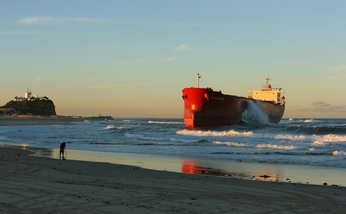
Bad weather, seamanship blamed for Pasha Bulker grounding: report

Bad weather, seamanship blamed for Pasha Bulker grounding: report

Posted Wed Jan 23, 2008 9:01am AEDT

The Australian Transport Safety Bureau (ATSB) has finished its draft report into the grounding of the Pasha Bulker off Newcastle, in the New South Wales Hunter, but expects to finetune the document before releasing the final paper in March.

NSW Maritime found the ship's grounding on Nobbys Beach was caused by horrendous weather conditions and poor seamanship by the ship's master.

The ATSB's probe is focusing on the conditions surrounding the event and the lengthy queue of ships off the Newcastle coast at the time.

A spokesman says the draft report will be sent to relevant stakeholders, including the Newcastle Port Corporation, allowing them to comment on the preliminary findings.

OTHER MARINE NEWS...

Hong Kong hydrofoils crash in fog

HONG KONG, China (AP) -- Two hydrofoils ferrying passengers between the Chinese territories of Hong Kong and Macau collided Friday night in heavy fog, seriously injuring 19 people, a Macau government spokesman said.

art.ferry.crash.ap.jpg


One of the damaged high-speed ferries docks in Macau.

The poor visibility was also blamed for a number of other maritime accidents in the region. Parts of China's southern coast were enveloped in fog due to a warm, humid maritime air stream.

The 10 men and nine women passengers seriously hurt in the Hong Kong-Macau collision suffered mainly head injuries and bone fractures that were not life-threatening, said Alex Che, a spokesman for the government of Macau. Another 114 passengers suffered lighter injuries, Che said.

"All the glass shattered and the front of the ship fell off," a male passenger, identified only by the surname Chan, told Hong Kong's Cable TV.

Wong Soi Man, director of Macau's Maritime Administration, said the accident's cause had not yet been determined, but "heavy fog must be one of the key factors."

The accident occurred closer to Macau and the injured were being treated there, he said.

In another incident, thick fog blanketed China's commercial center, Shanghai, where an unlicensed river ferry carrying 22 people capsized Friday, leaving 10 missing, China's official Xinhua News Agency reported.

The ferry, one of many that operate in the area without proper safety equipment or certification, sank near the city's Wusong pier shortly after the accident, Xinhua said.

And 66 people were rescued from a ferry that ran aground near the coastal city Zhuhai near Macau, Xinhua said.

Hours earlier, another high-speed ferry traveling west from Hong Kong to Macau and carrying more than 370 passengers hit a small fishing vessel, said Hong Kong Marine Department spokeswoman Daisy Lo.

No one was injured and both vessels continued their journeys.

Ferry operator Turbojet scaled back its services to Macau to once every half hour -- from its usual peak frequency of every five minutes -- and said travel time would take half an hour more than the usual one-hour journey.

The foggy weather slowed traffic on a key route that transports gamblers to booming casino enclave Macau, which surpassed the Las Vegas Strip in gaming revenue in 2006

FROM MARITIME BULLETIN

m/v Sergiy Skadovskiy sunk in Azov sea - 1/19/2008 04:11

January 19, Azov sea – m/v Sergiy Skadovskiy sunk in 45.59.6N 036.47.7E between 06.00-08.00 LT. Crew evacuated at 02.40, total blackout, energy for pumps from tug Portovik. 06.10 – emergency pumps and salvage team evacuated, further salvage attempts believed futile. Icebreaker Kapitan Belousov with vessels convoy left scene for Kerch strait, tug Portovik standing by to monitor sinking. m/v Sergiy Skadovskiy was enroute from Mariupol port to Black sea with 3100 tonns of grain on board. No further details, but looks like vessel was holed while under icebreaker convoy, either by ice or by some other vessel.


Sergiy Skadovskiy – dwt 3346, built 1985 USSR, flag Ukraine, owner UKRAINIAN COMMERCIAL FLEET, IMO 8725058.


AND

ONE MO TIME!

Beset in ice, some of the crew rejected evacuation - 1/20/2008 04:33

January 19, signal from EPIRB-406 – S&R plane from Khabarovsk spotted two non-propelled barges and two crafts beset in ice, with 14 people on board, all from gold mining private company. With mining cargo on board, they’ve been heading for Cape Odyan, 155 nm SW from Okhotsk port. Plane dropped food and other supplies. January 20 – helicopter from Nikolaevsk-on-Amur took on board 6 persons, others decided to stay with barges and crafts, maybe till spring time, waiting for clear water.


January 19, 08.50 LT – EPIRB-406 signal from 56.21N 140.13E (about 200 nm north off Nikolaevsk-on-Amur port). Area covered by ice 1 meter thick. Several vessels in the area directed to the scene, no communications, no radio alert. EPIRB-406 – owner unknown, last data 5-7 years old, former owner Sakhalin Dalso Co Ltd now unexisted. Regualr passenger flight Nikolaevsk-Okhotsk searched area, but spotted nothing. Signal loud and clear, air search under way.

LASTLY FROM HOLLAND AND KNIGHT

DHS – National Response Framework

The Department of Homeland Security (DHS) issued a news release stating that the National Response Framework (NRF), which replaces the National Response Plan, will come into effect 60 days after the official notice is published in the Federal Register. The NRF informs emergency management practitioners by explaining the operating structures and tools routinely used by first responders and emergency managers at all levels of government. It is designed to be scalable, flexible, and adaptable; always be in effect; and articulate clear roles and responsibilities among local, state, and federal officials. (1/22/08).


RS

Tuesday, January 22, 2008

Are we really prepared?

I am continually amazed by reports like the following. We are entering 2008 and still there are many County and State Emergency Management Agencies that still lacking the proper funding.

I have just one question. What's it going to take?

Preparedness center lags on hiring, training Jan 12, 2008 @ 05:27 PM By JENNIFER FUSCO Observer-Dispatch WHITESTOWN — New York state is spending $3.4 million this year on a state Preparedness Training Center that’s fallen far short of meeting initial projections for both employees hired and emergency responders trained.

Total spent: Close to $3,000 per police officer, firefighter, correction officer, health official or National Guardsman trained in 2007.

SLOW TO PREPARE
WHAT
* The State Disaster Preparedness Center was announced in December 2005 for the then-Oneida County Airport in Whitestown.

* Its purpose is to train emergency personnel for situations dangerous to the public including terrorist attacks.

THE GOAL
* State officials said it could become a hub for anti-terrorism training in the Northeast.

* Officials projected more than 25,000 trainees per year and the hiring of dozens of employees.

THE REALITY

* Fewer than 1,800 people have been trained, 641 in 2006 and 1,100 last year, the state says.

* The center employs 10 people.

* It lacks sufficient classroom space at the airport site and conducts some classes at Utica College.

PARTICIPANTS
* A total of 376 agencies used the center in 2007, according to the state Office of Homeland Security.

* Groups included the Fire Department of New York, the Syracuse fire Department, the Broome County Department of Health and the National Guard.

NEW HOPES

* The state said it will double the number of classes from 40 to 80 in 2008, serving an additional 275 emergency responders.


Local and state officials say they remain committed to the center, which opened two years ago in the terminal building of the former Oneida County Airport.

Still, some are concerned with its slow growth rate.

“This program needs to start moving in the direction of strong activity,” said Legislator William Goodman, D-Whitesboro. “It’s not moving fast enough.”

The O-D reviewed records and interviewed state and local officials about the center, which was once touted as New York’s hub for emergency-response disaster training for first responders.

The O-D’s findings include:
* The 10 people employed at the center represent only one-sixth of hiring goals.
Now, instead of as many as 60 jobs added in Whitestown, officials are projecting only 20.

* The 1,100 public-safety and health personnel trained in 2007 represent less than 5 percent of the initial projection of 600 trainees per week.

* More than two years after the center was created, it still lacks sufficient space at the former airport and must conduct some classes at Utica College. Officials blame the delayed signing of a lease.

* The O-D repeatedly requested a list of the employees at the center, as well as their titles and salaries, but the state failed to provide it. The O-D has filed a Freedom of Information Law request.

State officials offered no clear timetable for meeting initial projections for hiring and training.

Dennis Michalski, a Homeland Security spokesman, said classes at the center will double from 40 to 80 this year, but would not predict how many people would be trained in 2008.

“That's the unknown,” he said. “We can't speculate on numbers.”

Later, another Homeland Security spokeswoman, Jody Ankabrandt, said the number of trainees would rise at least 20 percent this year, or by about 275 people.

Initially, the center was supposed to train more than 25,000 emergency responders per year.

Classes will be on subjects such as cybersecurity, bombs and weapons of mass destruction.

State Assemblywoman RoAnn Destito, D-Rome, said she follows the progress of the center closely, and is confident it will grow as projected.

“As far as I’m concerned, the future is very bright for the Homeland Security center,” she said. “If I have any disappointment, it’s the time frame in which it’s been moving.”

Oneida County Executive Anthony Picente said it’s too early to tell if taxpayer money is being well spent at the Whitestown center.

“I don’t feel I can answer that right now,” Picente said. “If a year from now the same numbers exist, then it’s not.”

‘A model for the nation’

When then-Gov. George Pataki announced Whitestown would get the center in December 2005, officials hoped it would be the type of economic boost the area needed.

“Our goal is to develop this training facility into a federally recognized and accredited center, which will serve as a model for the nation and the training hub for the first response community from across the Northeast,” Pataki said at a Dec. 5, 2005, news conference. “The selection of the Oneida County Airportwill ensure that this important training begins as soon as possible.”

Leaders said the center would create jobs, boost local businesses and raise Oneida County's profile. The Convention and Visitors Bureau spoke of hotel rooms filled with hundreds of trainees each week.

Some trainees did come – from the New York Police Department, from Niagara County Emergency Management, from the Oneida Indian Nation. But they did not come in nearly the numbers initially expected.

On Friday, a sign declared the old airport terminal to be the home of the State Preparedness Training Center, but the building sat amid a vast expanse of empty parking lot, with only a few vehicles parked next to the structure. The center did conduct training, but at Utica College, which had available classroom space that the former airport site lacks.

Spitzer spokeswoman Jennifer Givner said the state is committed to the center and its growth.

“Clearly, I would say emergency preparedness is the utmost priority for the governor in this administration,” she said. “We’re definitely meeting the same numbers last year, with hopes to exceed that.”

Budget details sought
The center’s projected 2007-08 budget is $3.4 million, according to the state’s Budget Office. The O-D has filed a Freedom of Information Law request to learn just how the money is being spent.

The center employed nine people a year ago, and 10 now. Their names and salaries are also the subject of an O-D FOIL request.

The former airport ultimately should see about 20 employees working at the center, Destito said.

Homeland Security spokeswoman Amy Bonanno said there are 64 positions on the books for the center.

Some of those jobs will be in Albany, not Whitestown, but Bonanno said she was unsure of the breakdown.

Whatever the number, Picente said the center was never about the number of jobs. It was about making the region a hub for Homeland Security training and about an economic impact from high volumes of trainees traveling here.

“It’s going to take a couple of years to grow that much,” Picente said. “There’s no question it’s moving much slower than we thought, and I hope in this new year it will begin to move.”

Hope for progress
Why hasn’t more occurred?

Leaders cited the change in gubernatorial administration a year ago, as well as lease issues.

The lease between the county and the state was signed several months ago, which gives the center more space for additional programs and more training.

“I would hope we would see those numbers by June or so,” Picente said, referring to an increase in training numbers.

State Sen. Joseph Griffo, R-Rome, acknowledged the center hasn’t met its projections, but said part of that is due to the change in administration from Pataki to Spitzer — which happened shortly after the center first opened.

“Each administration has to pursue the direction they want to pursue,” he said.
Protecting the public remains a priority in the post-9/11 era, Griffo said. Having the center in Oneida County meets that need and also creates the potential for a greater economic impact locally, he said.

“I’ve got to give the benefit of the doubt to the administration,” Griffo said.
EDGE not involved

Mohawk Valley EDGE is the region’s main economic-development arm. It did not have a role in bringing the training center to the Mohawk Valley, spokesman Rob Duchow said.

He would not comment on the initial goals for the center.
“This is an investment that New York state wanted to make,” he said. “And for
them to invest in our community is good for us, opposed to investing in another
part of the state.”

The center is worth having as long as the state manages it right, Goodman said.
As for Legislator Goodman, he retains some optimism.

“The state itself will hopefully move more rapidly to make sure the goals are achieved that were presented in the past,” he said. “I think the concept is very good.”

Still, he said, he’d be watching.

“It should be an ongoing monitoring system,” he said.


MARITIME NOTES


Ministry of Transport requires report on Vanessa sinking
17 January 2008 | 13:31 | FOCUS News Agency
Sofia. Bulgaria’s Ministry of Transport sent a letter to the Ministry of Foreign Affairs requiring the Ukrainian part to introduce the report, worked out by the Commission engaged with the investigation on the Bulgarian Vanessa ship’s si1qazzzzzzz1qa1qa

On Wednesday, the Commission, established by Ukraine’s PM Yulia Timoshenko, has a sitting in Kiev. Bulgarian experts from the committee on ship accidents and failures to the Ministry of Transport and representatives of the Bulgarian embassy to Ukraine took part in the sitting.

RS


Friday, January 18, 2008

Its a day for ALERTS! Twisters and Ships!

While I have been blogging about the twisters we had in Illinois and Wisconsin. We are not the only ones who got hit.

I received a plea for help from a friend of mine who works for a local chapter of the Red Cross in Columbus, Mississippi. The Chapter has been responding to the damage done by a tornado around January 8 2008


I ask everyone who visits my blog to consider sending a donation to the "Local Chapter" to help them out. Mississippi is one of the poorest States in the United States so every penny counts....

If anyone wants a copy of some of the damage pictures from this twister please drop me a line.

Hi every one ;

My Chapter is in need of donations. We had a Tornado come through two of our counties we service. So far the operation has cost about $70,000.00 this does not qualify for a national response and we must provide all funds for this operation. We service 5 counties in
all at our chapter i am asking if you can send a small check to our Chapter to help with the cost. the Chapters name and address is:

Att: Pauline Redmond
Tenn-Tom Chapter of the American Red Cross
220 5Th Street North
Columbus, MS 39703
(662)328-5710

I am sending you some pictures we fed 21,000 meals and 36,00 snacks for residences and workers in the area.there are approximately 200 homes affected by this storm and two counties in our district. Thank you for listening our small chapter is in need because we
still have fire families and military cases that will rely on our funds through out the year.

Thank you

Pauline Redmond

Disaster Logistic Coordinator

Here is the NWS Jackson report on the tornado events.


January 10th Severe Weather

The second week of January 2008 was quite active with respect to severe weather. Two events impacted the region in a span of 3 days which produced several tornadoes, large hail and wind damage across the area.

On January 10th a vigorous storm system developed over the southern portions of the Midwest and moved northeast towards the Ohio valley. A strong cold front swept across the area during the late morning into the afternoon hours and strong to severe thunderstorms developed out ahead of it. All of the ingredients for tornadic development came into place as warm Gulf moisture pushed northward into the area out ahead of the front. The thunderstorms developed in eastern Louisiana and quickly moved across central Mississippi during the late morning and afternoon hours. As the storms progressed eastward, good instability combined with very strong wind shear for supercell development east of the Mississippi River, with the storms reaching maximum intensity along and east of the interstate 55 corridor.

Teams of National Weather Service meteorologists, with assistance from state and local emergency management officials, have been working to record and analyze storm damage across the area. After surveying the tracks of several severe storms across the area, the NWS has determined that eight tornadoes were produced across the central third of Mississippi by those storms.

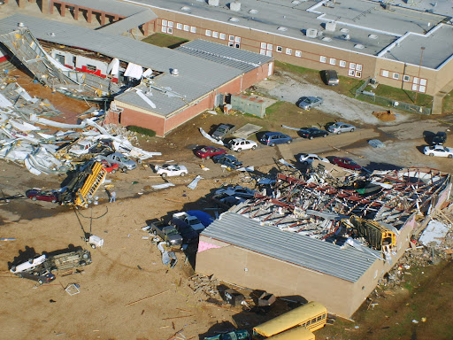
By far, the most damage was produced by a single "supercell" thunderstorm that moved from north of Vicksburg through north central and northeast Mississippi during the late morning and early afternoon hours. This single storm produced three strong tornadoes, all of which were rated as EF3 on the Enhanced Fujita tornado damage scale. The most significant damage occurred in Caledonia in Lowndes County, where a school gymnasium was destroyed along with a number of school buses and vehicles in the area. Even though the school complex had 1900 people in it at the time of the tornado, only three minor injuries were reported at that location. A tornado warning was issued for this area by the NWS in Jackson about 39 minutes before the tornado developed to the southwest of Caledonia, and approximately 41 minutes before the damage occurred at the school in Caledonia.

The longest track tornado from this event occurred in eastern Attala and Choctaw Counties. A tornado tracked for 24 miles from just west of the Ethel community in Attala County to about two miles south of Ackerman in Choctaw County. This was the tornado responsible for heavy damage to a dairy complex south of the Weir community. This is the longest track for a tornado in the central Mississippi region since the tornado outbreak of November 24, 2001.

The low-level circulation associated with this first supercell intensified as it approached Goodman in Holmes County, and it was apparent that a strong tornado had formed (KDGX radar image at 11:56AM). This intense circulation remained apparent in western Attala County near Sallis (KDGX radar image at 12:05PM), and in northeast Attala County from near McCool along the Natchez Trace Parkway into Choctaw County (KDGX radar image at 12:48PM).

The low-level circulation reintensified upon entering northern Lowndes County in the Columbus AFB vicinity (KGWX radar image at 2:07PM) where severe wind gusts greater than 60 mph were observed. A strong tornado touched down near Caledonia (KGWX radar image at 2:16PM) before moving east into Alabama.

A second supercell that organized near the Mississippi River in southwest Mississippi before midday tracked from Claiborne County, through the northern Jackson Metropolitan Area, and finally into Noxubee county in northeast Mississippi by mid afternoon. This storm was responsible for 5 different tornado touchdowns along its path, as well as many reports of high winds and hail. National Weather Service storm survey teams rated these tornadoes as EF0s and EF1s and a majority of the relatively minor structural damage associated with them occurred just southwest of the Pearl River Resort in Neshoba County.

The National Weather Service would like to thank officials from MEMA and the affected counties` Emergency Management Directors for their assistance in performing these damage surveys.

*NOTE: All radar images are 0.5 degree, Storm Relative Velocity and Reflectivity.

Damage Reports


Preliminary Local Storm Reports

Here are some of the reports on these rare January 2008 tornadoes from NOAAWatch

Severe Weather in the Lower Mississippi Valley and Washington State
Fri, 11 Jan 2008 08:07:51 EST
Approximately 140 reports of severe weather were received throughout parts of Tennessee, Kentucky, Illinois, Louisiana, Georgia, Mississippi, Alabama, and Washington. The majority of these reports were wind damage reports. 21 tornadoes were reported throughout parts of Mississippi, Alabama, Louisiana, and Washington. While no fatalities have been reported, at least 18 injuries have occurred with the storms in Alabama and Mississippi. Numerous homes, farms, businesses, and other structures have also been destroyed or damaged. In Caledonia, Mississippi, a tornado struck an elementary school campus, destroying the gymnasium and heavily damaging other school structures. Three children were injured at the school. Details...

Severe Weather Reported Wednesday
Thu, 10 Jan 2008 07:43:06 EST
There were numerous reports of wind damage across parts of New York on Wednesday. A peak wind gust of 66 mph reported at Massena NY. Many other reports of 55 to 60 mph winds across St Lawrence county. Numerous roofs are reported damaged/blown off. At least one tractor trailer was reported to be tipped over by the high winds. Details...

Severe Weather Reported Tuesday
Wed, 09 Jan 2008 05:47:24 EST
Tornadoes were reported on Tuesday in Arkansas, Missouri, and Tennessee, with one death reported in Arkansas. Penny size to golf ball size hail was reported over parts of Texas, Arkansas, Mississippi, Alabama, and Tennessee. Damaging winds were reported from the Lower Mississippi Valley, across parts of the Ohio Valley, and into western New York. Details...

Deadly tornadoes across the Midwest
Tue, 08 Jan 2008 05:49:16 EST
Tornadoes were reported Arkansas, Missouri, Illinois, and Wisconsin. Two deaths were reported with the tornadoes. Damaging thunderstorm winds and large hail were reported extending from Oklahoma into Michigan and Wisconsin. Baseball size hail was reported in several locations in Missouri. Details...


MARITIME STORY - SWASH
Severe Weather Automated/Assisted Ship Handling (SWASH)
Written by Professor Dick K.P. Yue and Dr. Yuming Liu
Center for Ocean Engineering


 We envisage a scenario in the near future that a fleet of agile unmanned surface vessels (USV), capable of cruising at high speed and following optimized courses through severe environmental conditions, can carry payloads and/or perform missions heretofore impossible or too dangerous for manned ships.

Based on real-time sensing and forecasting of the environment and other factors, and optimum autonomous control, such vessels are able to make rapid maneuvers to negotiate or evade extreme wave conditions and/or hostile pursuers. The surface vessels allow favorable payload to fuel requirements compared to airborne (or submarine) platforms. On the other hand, the possibility of these vessels serving as platforms for drone airplanes or AUVs, and even themselves becoming airborne or submerged at a certain phase of the mission may provide a powerful paradigm shift in naval operations.

The realization of the above scenario requires the development and integration of a number of capabilities all to be performed in real time: (1) sensing of the local wave field; (2) forecasting of the local wave field; (3) prediction of the vessel responses in waves; and (4) control and optimization of the vessel(s) and course. Recent developments in each of these areas, especially in sensing and forecasting of nonlinear wave fields, have substantially increased the possibility for this to be achieved.

The objectives of this study are: (i) to develop a virtual simulation environment to demonstrate the feasibility of applying advanced technologies in these areas to enable substantial improvements in operational capability for single/multiple unmanned/manned surface vehicles traveling under stressing environmental conditions; (ii) to identify the key developments necessary for the realization of this capability in the near future; and (iii) (ii) to develop the technologies in the bottleneck areas, especially in wave prediction, to bring this capability to real-time applications in realistic environments.


UPDATE ON ICE PRINCE - MCA ALERT

MV ICE PRINCE

ICE1

At 19:08hrs on Sunday 13 January 2008 the 6467 GRT cargo vessel MV ICE PRINCE in a position of 27 nautical miles south east of Start Point, Devon, reported that her cargo of timber had shifted resulting in a 25-35 degree list to port.

Attempts were made on Monday 14 January to put salvors on board the vessel, however this was thwarted due to adverse weather conditions

In the early hours of Tuesday 15 January the vessel started to sink in a position 26 miles SSE of Portland Bill. The vessel is now at a depth of 62 metres.

The Trinity House vessel ‘PATRICIA’ is en route and on arrival will be laying emergency buoys around the site. A full survey of the wreck site will be carried out on Thursday 17 January 2008. To ensure that the wreck does not pose a hazard to navigation a guard vessel, the Klyne Tug ‘ANGLIAN EARL’, will remain on scene until the survey has been completed.

A Temporary Exclusion Zone of 1000 metres has been implemented around the wreck site.

It has been confirmed that the vessel was carrying 5,258 tons of packaged untreated sawn timber of differing sizes; 2,516 tons on deck and 2,742 tons in the holds. An estimated 2000 tons broke free when she sank. Some of these packages have broken up into individual pieces.

A contractor has been appointed to recover any timber washed ashore. SOSREP has requested that the owners also arrange for recovery at sea of timber in estuaries and inshore waters.

Anyone finding any cargo should report it to the MCA's Receiver of Wreck (ROW) [see link below for fuller details]. Police forces along the south coast have been authorised by the ROW to act on her behalf. People failing to comply with their directions would be comitting an offence for which they may be convicted and fined up to £2500.

ice 2.

There have been reports of a sheen of oil on the surface of the wreck site, but this is being broken up by wave energy and natural sea movement. The salvors are currently planning how best to recover, with minimal risk to the environment, the oil and pollutants that are currently contained within tanks on the vessel.

MCA are conducting remote sensing aerial surveillance flights to ascertain the extent of the pollution. These aircraft have sensing equipment which can accurately assess the amount of oil on the sea surface both during the day and at night. In addition, the MCA have requested satellite imagery from EMSA (European Marine Safety Agency). Satellites will also be used to monitor the discharges of oil.

Please report any sighted timber to Solent Maritime Rescue Coordination Centre on

02392 559021

02392 559022

Where a vessel is wrecked ... any person (who) conceals or keeps possession of any such cargo or refuses to deliver any such cargo or article to the receiver. It is also an offence of failing to report the wreck to the Receiver.

ICE PRINCE further information/contacts/ Q&A

London Club Warns on Heavy Weather Personal Injuries London Club Warns on Heavy Weather Personal Injuries

THE London P&I Club reports that recent personal injury cases which it has handled have included accidents in which the ship’s motion in heavy weather has been a causative factor.

In the latest issue of its StopLoss Bulletin, the Club notes, “The types of incidents reported have included injuries to crew members falling while working aloft, a hand injury when a heavy auxiliary engine part unexpectedly shifted while being removed for maintenance, and a chest injury suffered when a power tool slipped as a ship rolled.

“Where a risk assessment had been carried out in respect of the accidents involving deck crew, the responsible officer had been fully aware of the prevailing conditions but had not made sufficient allowance for the ship’s motion.

“Interestingly, in the cases where the task was being performed in the engine room, the entry on the risk assessment form for ‘Weather and Sea Hazard’ was in each case “not applicable”.”

The Club concludes, “While it is the case that dealing with rolling, for example, is less of an issue for someone on the bottom plates in the engine room than it is for a crew member on the monkey island, these recent cases are reminders that, when a ship rolls, the engine room moves too.”

  • The London P&I Club, managed by A Bilbrough & Co, is one of the leading clubs in the International Group of P&I Clubs. It pursues a policy of selective, quality expansion and strategic investment to maintain financial strength.


Chicago Weather ALERT! Cold does not even express it!
Have warm and great weekend!
RS

Thursday, January 17, 2008

Weather? HA! The Work Goes On!

Work is under way today to refloat the Walter J. McCarthy Jr. by pumping water out of the laker’s ballast tanks.

The 1,000-foot-long laker’s engine room flooded Monday after a submerged object punctured the McCarthy’s hull as the ship was backing into a slip at Superior’s Hallett No. 8 Dock about 11:30 a.m. The McCarthy’s crew closed the engine room’s watertight doors and evacuated the room as the ship’s stern settled to the bottom in 20 feet of water.

“Calculations support that the vessel will float regardless of the flooded engine room if de-ballasting occurs,” the U.S. Coast Guard said in a news release. “To do so, the vessel will utilize shore power to operate internal and external pumps. Engineers involved in the salvage believe it will take two to three days to complete the de-ballasting.”

Work to empty the ship’s ballast tanks began Tuesday evening. The tanks hold lake water to help stabilize the ship when it is empty or lightly loaded.

Once the ship is refloated, divers will be able to determine the extent of the damage to the McCarthy’s hall. After the ship’s hull is patched, the water in the engine room will be pumped to trucks for proper treatment and disposal.

The water fills the engine room to a depth of 20 feet, covering the ship’s four 3,500-horsepower General Motors Electro Motive Division diesel engines. Response personnel estimate that approximately 450 gallons of miscellaneous oils have been removed from the flooded engine room, the Coast Guard said. There are an additional 2,500 to 3,000 gallons of oil and fuel in adjacent tanks, engines and generators, but there is no threat of those liquids escaping, the Coast Guard said.

Once the engine room is pumped dry, officials will be able to determine if the ship can be repaired where it is or whether it will have to enter dry dock.

Workers may rebuild the ship’s engines where it sits now, said Rhonda S. Johnson, spokeswoman for GATX, the parent company of the McCarthy’s owner, the American Steamship Co.

The McCarthy is 1,000 feet long, 105 feet wide and has a dead weight capacity of 62,100 gross tons at a draft of 27.5 feet. The ship transports western coal from Superior to Detroit Edison’s St. Clair and Monroe, Mich., power plants. Built as the Belle River by the Bay Shipbuilding Corp. at Sturgeon Bay, Wis., the ship entered service in 1977. It was renamed the McCarthy in 1990 to honor the former chairman of the Detroit Edison Company.




UPDATE ON THE ICE PRINCE

Here are two recent videos regarding the Ice Prince a cargo ship loaded with more than 300 tonnes of oil which sank in the Channel 26 miles south-east of Portland Bill, spilling its load of timber.

Environmentalists are concerned that coastline and marine life could be harmed if storms breach the hull of the Ice Prince. There were also worries that if its cargo of wood washes up in southern England there could be a repeat of the chaotic scenes a year ago when scavengers descended on the Devon coast after the MSC Napoli shed about 50 containers.


UK. Receiver of Wreck warns against stealing MV Ice Prince cargo

Wednesday, 16 January 2008

At a meeting this morning convened by the Secretary's of State Representative for Maritime Salvage and Intervention (SOSREP) Hugh Shaw, various options were discussed on minimising the impact of the loss of cargo or oil from the sunken `Ice Prince.

Representatives from the Environment Group, Police, local authorities and the owners and salvors also attended the meeting.

A guard vessel, the Klyne tug, "Anglian Earl" will remain on scene until Trinity House have completed their survey of the wreck site. This is to ensure that the wreck does not pose any hazard to navigation.

The salvors are currently working on a plan to decide how best to recover the oil and pollutants that are currently contained within tanks on the vessel to minimise the risk of environmental impact.

There have been reports of a light sheen of oil on the surface at the wreck site, but this is being broken up by wave energy and natural sea movement.

The timber cargo that broke free from the vessel when she sank is estimated to be 2,000 tons of untreated sawn timber of differing sizes. Already some of the packages have broken up into individual pieces.

Discussions are taking place with the owners to appoint a contractor to be responsible for the collection of the cargo.

The MCA anticipate the cargo of timber will reach land between the Dorset/Hampshire border and East Sussex.

Police forces along the south coast are working closely with the Maritime and Coastguard Agency and the Receiver of Wreck.

Police Forces have been authorised by the Receiver of Wreck to act on her behalf. People failing to comply with their directions would be committing an offence for which they may, on conviction, be fined up to £2,500 - and may be arrested.

Under Sections 236 and 237 of the Merchant Shipping Act 1995: an offence would be committed: where a vessel is wrecked ... any person (who) conceals or keeps possession of any such cargo or refuses to deliver any such cargo or article to the receiver...'

It is also an offence of failing to report the wreck to the receiver.

Under current control measures that are in place any birds or wildlife found dead should be reported immediately to the RSPCA on their emergency number 03001234 999 who will respond appropriately.

WEATHER STORY

NWS Chicago (Lot)
has posted its Skywarn Spotter training schedule...

Severe Weather Spotter Talk Schedule

Below is a listing of upcoming severe weather spotter talks...
Click here to see the Spotter Training FAQ page

February, 2008 - Upcoming
Day City, State Time Location
11 Naperville, IL
(DuPage County)
7:00pm CST City Hall, Council Chambers, 400 S. Eagle.

Contact Information: 630-742-3782
13 Evergreen Park, IL
(Cook County)
7:00pm CST Fire Dept., 9000 S. Kedzie Ave.

Contact Information: 312-603-8180
20 Kankakee, IL
(Kankakee County)
7:00pm CST Kankakee Community College, Auditorium

Contact Information: 815-802-7174
25 Minooka, IL
(Grundy County)
6:30pm CST Fire Station 1, 413 W. Mondamin St.

Contact Information: 815-941-3200
26 Sandwich, IL
(DeKalb County)
7:00pm CST TBA


27 Plainfield, IL
(Will County)
7:00pm CST Police Dept., 14300 S. Coil Plus Dr.

Contact Information: 815-740-8351

March, 2008 - Upcoming
Day City, State Time Location
03 Evanston, IL
(Cook County)
2:00pm CST Civic Center, 2100 Ridge Ave

Contact Information: 312-603-8180
03 Evanston, IL
(Cook County)
6:00pm CST Civic Center, 2100 Ridge Ave

Contact Information: 312-603-8180
06 Dixon, IL
(Lee County)
7:00pm CST Public Safety Building, 220 S. Hennepin Ave.

Contact Information: 815-284-3365
10 Ottawa, IL
(La Salle County)
7:00pm CST Ottawa High School, Room 420, 211 E. Main St.

Contact Information: 815-433-5622
11 Oglesby, IL
(La Salle County)
7:00pm CST Illinois Valley Community College, Room 316

Contact Information: 815-433-5622
12 Melrose Park, IL
(Cook County)
7:00pm CST Senior Center, 900 N. 25th Ave.

Contact Information: 312-603-8180
13 Warrenville, IL
(DuPage County)
7:00pm CST City Hall, 28W701 Stafford Place

Contact Information: 630-682-7925
15 Wheaton, IL
(DuPage County)
8:00am CST Wheaton College, Coray Gym ***There is a fee. Must Register in Advance***

Contact Information: 630-682-7925
17 Aurora, IL
(Kane County)
10:00am CST City Council Chambers, 44 East Downer Pl.

Contact Information: 630-801-6512
17 Aurora, IL
(Kane County)
7:00pm CST City Council Chambers, 44 E. Downer Pl

Contact Information: 630-801-6512
18 Lockport, IL
(Will County)
7:00pm CST Lockport Central High School, Auditorium, 1222 S. Jefferson St.

Contact Information: 815-740-8351
19 Joliet, IL
(Will County)
10:00am CST County Building, 2nd Floor Board Room, 302 N. Chicago St.

Contact Information: 815-740-8351
19 Wilmington, IL
(Will County)
7:00pm CST City Hall, 1165 S. Water St.

Contact Information: 815-740-8351
20 Pontiac, IL
(Livingston County)
7:00pm CST Public Safety Building, 413 N. Mill St.

Contact Information: 815-844-7171
22 Rockford, IL
(Winnebago County)
8:30am CST Chicago-Rockford Int'l Airport, Public Safety Building

Contact Information: 815-987-5990
24 Clarendon Hills, IL
(DuPage County)
7:30pm CST Church of Holy Nativity, 55th and Richmond.

Contact Information: DuPage Radio Club www.w9dup.org
26 Lyons, IL
(Cook County)
7:00pm CST Lyons EOC, 7801 Ogden Ave.

Contact Information: 312-603-8180
27 Crystal Lake, IL
(McHenry County)
7:00pm CST McHenry Community College, Auditorium

Contact Information: 815-338-6400
31 Tinley Park, IL
(Cook County)
7:00pm CST Admin Building, Kallsen Conference Room, 16250 S. Oak Park Ave.

Contact Information: 312-603-8180

April, 2008 - Upcoming
Day City, State Time Location
02 Matteson, IL
(Cook County)
10:00am CST Matteson Village Hall, 4900 Village Commons

Contact Information: 312-603-8180
03 Crown Point, IN
(Lake County)
7:00pm CST Civic Center, 101 East St.

Contact Information: 219-755-3549
09 Arlington Heights, IL
(Cook County)
9:30am CST Public Works Dept., L.A. Hansen Building, 222 N. Ridge Rd.

Contact Information: 312-603-8180
09 Arlington Heights, IL
(Cook County)
1:30pm CST Public Works Dept., L.A. Hansen Building, 222 N. Ridge Rd.

Contact Information: 312-603-8180

RS