Monday, August 25, 2008

Deadly dangers of the deep

Deadly dangers of the deep

So you thought flying was the most dangerous part of your holiday? Jimmy Lee Shreeve reveals why going to the beach is even riskier.

Heading for the beach this summer? Then be very careful out there: you could be exposing yourself to a raft of dangers and health hazards. Take jellyfish. There are 2,000 species, 70 of which can seriously harm, even kill you. Lurking in the waters of Australia's Great Barrier Reef for example is the Irukanji jellyfish, a tiny (one inch in diameter), but particularly venomous critter that has claimed the lives of quite a number of swimmers in the region.

In 2002, 58-year-old British tourist Richard Jordon was stung while swimming near Hamilton Island, off the coast of Queensland, and died several days later. That same year, 44-year-old American tourist Robert King also died after a brush with the Irukandji while out for a swim in the same area.

Another deadly jellyfish found in Australia, the Philippines and other tropical areas is the Box. Contact with one of its three-and-a-half-inch tentacles can kill you within three minutes. In January 2006, a seven-year-old girl, swimming on Umagico Beach, Cape York Peninsula, died of heart failure after being stung. Her death followed that of seven-year-old Jarred Crook in 2003, who was killed when a jellyfish wrapped its poisonous tentacles around his legs and torso in shallow waters at Wongaling Beach, south of Cairns.

But what about closer to home? The jellyfish that are found along the Spanish coast may not be as venomous as those in Australia, but they pack a mean sting all the same (occasionally requiring a trip to hospital). Not only that, but large numbers of jellyfish have been drifting into Spanish waters over the last year or so due to over-fishing and climate change. Last summer 19,000 people reported being stung on the Costa Brava, while in August alone around 400 people were treated for stings off Malaga. "It's very possible that we can expect a new influx of jellyfish this year," warns Xavier Pastor, executive director of environmental group Oceana.

It's not just holidaymakers in Spain who need to worry: at this year's Cannes Film Festival, Hotel Rwanda star Don Cheadle was swimming with his daughter when he was stung.

Some of the most beautiful beaches in the world are found in the Caribbean and Florida. Unfortunately, taking a dip in the inviting crystal-clear seas in either location could lead to a close - and very painful - encounter with a Portuguese Man O' War. Earlier this year, British Olympic sailing ace Nick Rogers, 29, was stung by one before a regatta in Miami. "I was thrashing around in so much pain I capsized," he said.

Similar to a jellyfish (but not a jellyfish), the Man O' War's venomous tentacles stretch from 10 to 30 feet. When a human body comes into contact with a tentacle, thousands of harpoon-like stingers inject poison into the skin. Stings from a Man O' War aren't lethal, but can be dangerous to anyone with a weak heart or serious allergy. Bob Taylor, the ocean rescue superintendent at Delray Beach, Florida, says the best thing to do if stung by a Man O' War is to remove the tentacles with a stick or towel (not with bare hands) and treat the infected area with vinegar.

But what about the marine creature perceived to be the most fearsome of all - the shark? Is it really the biggest menace of the seas and beach resorts? "The total number of shark attacks worldwide increased from 61 in 2005 to 62 in 2006 and the number of fatalities remained stable at four," says George Burgess, director of the International Shark Attack File kept at the Florida Museum of Natural History. "It's really quite remarkable when you have only four people a year die... [It] puts in perspective how small shark attack is as a phenomenon."

Nevertheless, last year Burgess tracked seven attacks in Australia, four in South Africa, three in Brazil, two in the Bahamas and one each in Fiji, Guam, Mexico, New Zealand, Puerto Rico, Réunion, Spain and Tonga. "Some tourists bring their aquatic recreation to places known to be shark-infested without asking [the locals] about good and bad places, [and end up] getting grabbed by the tiger shark," Burgess says.

So would you be safer taking a beach holiday here in Blighty? Not if the alleged sightings of the great white shark (made notorious by the movie Jaws) are anything to go by. One sighting was reported in 2002 by lobster fisherman Brian Bate.

He was heading towards his regular fishing ground when he saw something large leap out of the water. "I thought, 'What was that?' " he recalls. "It was quite a size to come right out of the water.

When I approached there was all this blood in the water..."

But let's say you steer clear of the sea and stay on the beach, maybe indulge in the odd ice cream to cool down. That's got to be a surefire way of keeping out of danger, hasn't it?

Well it depends on the ice-cream vendor. Over the last decade or so various tests on ice creams bought in leading tourist attractions in Europe, including Barcelona and Rome, have failed UK hygiene standards due to contamination by bacteria.

Inspectors in Barcelona reported seeing a man urinate against a wall and return to his ice-cream van without washing his hands. Eleven out of 20 samples of his ice cream failed basic hygiene standards and Listeria was found in one.

Hotdog stands fare little better, particularly the unlicensed ones which are all too common around beach resorts. Leaving aside the artery-clogging levels of saturated fats and salt, inspectors regularly find inadequate refrigeration and a lack of probe thermometers (used to make sure raw meat is cooked at the correct temperature). Lack of hand-washing facilities is another issue highlighted by hygiene inspectors. It brings a high risk of food becoming infested with germs, especially after a vendor has handled raw meat or cash.

But even if you resist the lure of junk food, you could still come unstuck. We all know by now the dangers of sunbathing, but even if you daub yourself from head to toe in factor 50 sunblock, spending time on the beach can still prove hazardous.

In June 2005, scores of beach-goers were stretched out on the sands of Portugal's Carcavelos beach when some 500 youths swarmed into the crowd, robbing them of money and valuables. Five people, including two police officers were injured during the mass mugging...

Montezuma's revenge on Britain's beaches

Never mind sharks and jellyfish, the biggest danger to swimmers in Britain is sewage. According to the latest Good Beach Guide, published by the Marine Conservation Society, raw and semi-filtered sewage is pumped directly into the sea at 73 spots along our coastline and swimmers have a one in seven chance of catching a stomach bug at more than 100 British beaches.

These figures may be worrying but they actually represent a big improvement on previous years. As the society points out, the bathing quality of water at 60 per cent of Britain's beaches is perfectly acceptable. Which would be comforting, were it not for the fact that a shift in rainfall patterns caused by global warming could undo much of the good work: increased storms will sweep more pollutants from the land directly into the sea and could take pollution back to previously high levels. Check out Britain's cleanest beaches at www.goodbeachguide.co.uk.

WEATHER NOTE

Rare mountain tornado strikes Park County

Park County tornado near Eleven Mile Reservoir. Image courtesy 7News and Jerry Bivens.

In a truly unusual weather occurence, a tornado struck near Eleven Mile Reservoir in Park County Saturday afternoon. Certainly we are all used to hearing about twisters along the Front Range and on the plains but mountain tornadoes are quite rare - the rugged terrain usually disrupts the weather patterns necessary to product tornadoes. Authorities estimate five vehicles were damaged including a motorhome and pickup truck camper that were overturned, a trailer was destroyed. Beyond cuts and scrapes, thankfully no one was injured.

Colorado is ranked ninth in the country with an average of 40 tornadoes a year. It is interesting to note that every state in the union - including Alaska and Hawaii - have had tornadoes.

Doing some research at the TornadoProject.com yields an interesting fact as well. This was Park County’s first tornado ever. That leaves 12 of Colorado’s 64 counties that have never had a tornado including:

Clear Creek
Dolores
Garfield
Gilpin
Gunnison
Hinsdale
Lake
Montrose
Ouray
San Juan
San Miguel
Summit

It does serve as a reminder that while the unofficial severe weather season is behind us, Colorado’s weather is anything but boring and everyone should be aware of all the types of weather hazards that are possible.

Tropical Storm Fay: St. Johns flooding

River's worst yet to come

It could rise fast -- but not drop for weeks, say forecasters

|Sentinel Staff Writers

The St. Johns River could hit Central Florida this week with some of the worst flooding on record.

Runoff from Fay is gorging nearly every part of the 310-mile St. Johns River, which forms south of Melbourne and flows north to the Orlando area and on to Jacksonville.

"Geneva, Astor and other areas will see moderate and major flooding," forecaster Todd Hamill at the Southeast River Forecast Center said Saturday night. "There's just a lot of water and no place for it to go."

Even in ordinary times, the meandering St. Johns drains to the Atlantic Ocean very slowly. During heavy rainfall, it grows wider rather than flow much more quickly.

Fay brought more than heavy downpours. Some parts of Brevard County received in two days as much rain as the area would see in six months.

"It will take a lot of time for levels to drop, probably weeks," Hamill said.

The 11 people killed in Florida and one in Georgia bring the death toll from Fay to at least 35. A total of 23 died in Haiti and the Dominican Republic from flooding.

Fay has been an unusual storm since it was named Aug. 15. After hitting the Keys on Monday, it crossed open water again before hitting a second time near Naples on the southwest coast. It limped across the state, popped back out into the Atlantic Ocean and struck again near Flagler Beach on the central eastern coast. It was the first storm in almost 50 years to make three landfalls in the state as a tropical storm. Its fourth landfall as such -- near Apalachicola -- was the first in recorded history.

Hamill said with the region so saturated with Fay's rainfall, flooding could get much worse with just the precipitation of afternoon showers.

Neighborhoods along the north shore of Lake Monroe are bracing for high waters.

Forecasters say that by Tuesday, flooding may make roads impassable and even swamp some homes in the Stone Island subdivision in Volusia County.

"We've seen a huge rise in the water," said resident Karen Lee. "The only thing we can do is pray a whole lot. That's the only thing we can do."

'Can't just bottle them up'

River experts agree.

For the next several days, a number of swollen waterways will surge into the St. Johns. Among the bigger tributaries are the Wekiva and Econlockhatchee rivers in Orange and Seminole counties.

There's no way to stop their flows.

Water officials can briefly hold back Jane Green Creek in Brevard County by closing a dam gate. But that brings the risk of catastrophic flooding if rising waters breach the dam.

Elsewhere, the upper reaches of the St. Johns River are buffered by more than 60,000 acres of reservoirs.

They went from nearly empty to nearly overflowing last week. Holding back that water has lessened the surge down the St. Johns River.

But now officials are draining those reservoirs as quickly as they can.

"We can't just bottle them up," said Jeff Elledge of the St. Johns River Water Management District. "They would fill up, and their dikes would burst."

Water-district officials might open canal gates that allow water to flow from the upper reaches of the river to the Indian River Lagoon along the coast. But that's an option of last resort because of significant environmental harm that results by dumping fresh water into a slightly salty ecosystem.

Still, even sending water to the coast will do little to head off flooding in Central Florida, Elledge said.

"There's going to be flooding and no way to stop it," he said. "It's a matter of trying to get out of the way of the river."

Turn into a lagoon'

Floodwaters along Lake Harney near Geneva should crest at about 18 inches above flood stage, likely causing significant flooding to homes and roads.

Tony Cristaldi, senior forecaster with the National Weather Service in Melbourne, said flooding in that area is likely to push toward record levels.

"I suspect through next week the river will stay at flood stage," Cristaldi said. "It's forecast to crest and kind of just stay there," he said. "The areas just turn into a lagoon."

Along Lake Monroe, the water might reach 4 inches above flood stage, blocking roads into the Stone Island and Stillbrook subdivisions, and while in the DeLand area it could top 6 inches above flood stage.

Water could enter buildings around Hontoon Island and flood docks at nearby marinas.

"What we've got to hope and pray for is that we don't have another tropical system come our way," said Scott Hagen, a University of Central Florida professor who studies the river.

Official offers tips for severe weather survival

August 20, 2008

PORTAGE --- As far as the Porter County Emergency Management director is concerned, it's not over until it's over when it comes to the severe weather of 2008.

Phil Griffith spent an hour Tuesday afternoon informing the seniors at Miller's Assisted Living about the facts and misconceptions of thunderstorms, lightning, tornadoes and flash floods.

Center residents watched the presentation that Griffith regularly gives to groups all over the county, learning the details of what emergency management officials have in place to protect them and what they need to do to make themselves safe during severe weather.

"The United States averages about a thousand tornadoes a year, but this year we're going to see 1,300 or 1,400," he said.

He outlined the system of trained volunteers who are a critical link in confirming whether wind damage, such as that suffered in Valparaiso on East Lincolnway and Campbell Street, was caused by a tornado.

"We have 105 spotters in SKYWARN who report to the (National Weather Service), because Doppler radar can't see tornadoes, just moisture rotation. There was rotation over the city, but not a tornado," he said.

The reason is that a tornado is defined as a rotating column of air that extends all the way to the ground, while a funnel cloud doesn't touch the ground.

"The roof blew off Jimmy John's, but there was no twisting," he said.

Griffith said the damage suffered in Pine Township two years ago was from straight-line winds of more than 100 miles an hour, not a tornado.

He said Porter County benefits from its position downwind from Lake County when it comes to weather alerts, as with the Kohl's tornado that struck U.S. 30 in Hobart without warning in 2001.

"They had 30- to 45-seconds warning; didn't see it coming. But that gave us five or six minutes," he said.

He recommended buying an inexpensive weather radio from Wal-Mart or Radio Shack, either a $20 seven-channel model that sounds an alert for severe weather anywhere in the Chicago area, or a $40 to $50 one that can be programmed to go off only for Porter County alerts.

Miller's Personal Care Assistant Tasha DeMaria said the residents participate in unannounced drills for severe weather and fires four times a year and attend periodic classes to review emergency procedures for power outages, blizzards, severe heat and earthquakes.

MORE TORNADOES


TORNADOES - Funny home videos are a click away

MARITIME NOTE

Dangers of the Deep

Fishing is one of America's most perilous jobs. Can anything be done to make it safer?

By Alex Markels

There was nothing perfect about the storm that capsized the Northern Edge as it scoured the sea bottom off Nantucket, Mass., for scallops last winter.

It was five days before Christmas, and the 10-foot waves kicked up by an approaching low-pressure system made the 75-foot boat bob like a rubber duck in a bathtub. As the boat's six-man crew raced to top off their catch, one of the dredges that scoop up the shellfish got hung up on the seafloor. Its cable tightened, and the vessel listed sharply to starboard. Water gushed over the rail, swamping the deck and flooding the engine room and crew compartments.

Unable to clear the water from the deck or reach their neoprene survival suits, the crew members scrambled to free a life raft, but it fell overboard before they could inflate it. So deckhand Pedro Furtado jumped into the water, grabbed hold of the raft, and pushed the inflate button. Then he called to the others to abandon ship, but only one jumped overboard.

Doomed. Within 10 minutes, the Northern Edge rolled over and sank, drowning the remaining crew members and leaving Furtado floating alone on the high seas until he was rescued by another fishing boat. "They were there, and then all of a sudden they weren't," the 22-year-old native of Portugal recalls of a moment he has spent the past five months trying to forget.

The sinking was New England's worst fishing accident since 1991, when the Andrea Gail and its six crew members were lost in the "perfect storm," later recounted in a book and movie. But the Northern Edge tragedy was hardly a rare occurrence. Commercial fishing ranks among the nation's most dangerous occupations (chart, Page 45), despite safety rules passed by Congress more than a decade ago. In 2003 (the most recent year for which data are available), an average of about one fisherman died on the job every week--while many others suffered serious injuries.

Fishermen are a famously independent bunch, and they have long resisted the sort of safety regulations that are compulsory in other workplaces. Against their opposition, the first and only law aimed at improving the industry's safety record was passed by Congress in 1988. The Commercial Fishing Industry Vessel Safety Act requires boats to carry life rafts, survival suits, and emergency beacons in the event of an accident--steps that Coast Guard officials say have since helped lower the number of annual fatalities.

The Coast Guard has other safety rules as well. But provisions to prevent an accident--such as requirements that most boat captains be licensed and submit to mandatory dockside safety examinations--have never been passed. The Coast Guard now conducts voluntary examinations, but only about 6 percent of boats participate. "The fishermen aren't going to do it on their own," says Capt. Michael Karr, chief of the Coast Guard's investigations and analysis office. "Until we make inspections mandatory, we're going to have 60 people drown and 140 boats sink every year." Karr and his colleagues have repeatedly asked for legislation to do just that, including a proposal presented to Congress last week that would create a pilot program for mandatory dockside examinations.

Skeptics. Some lawmakers aren't convinced. "We have the best safety requirements of any fishing nation in the world," argues Don Young, a Republican from Alaska who heads a congressional committee that oversees the Coast Guard. Young plans to review the Coast Guard's proposal, but he's skeptical. "We'll see whether it's justified or if it's just another attempt to have more government intrusion in private enterprise," he says. "Why should some snot-nosed lieutenant say you can't go fishing because of this or that?"

Fishermen complain that more safety rules would further choke an industry already suffering from government-imposed catch limits. Amid concerns about declining fish populations, regulators have also moved to limit catches, shorten fishing seasons, and declare some prime fishing grounds "off limits" until fish populations recover. Fishermen argue that some of those limitations have actually made commercial fishing less safe by increasing the pressure on them to make the most of their time at sea, even when weather conditions might otherwise send them back to port.

In the case of the Northern Edge, some pointed out, a complicated rule had forced the boat to return from a previous fishing trip before it had filled its quota. Given a short time window to complete a "compensation trip" the following month, the boat's captain "was under a lot of pressure to stay out there and make up for all the time and fuel he'd already spent," says Herman Bruce, a longtime scalloper from New Bedford, Mass. Under public pressure, regulators have since eliminated the controversial rule.

Some express similar concern over the fate of the Big Valley, which went down in rough seas off Alaska during last January's snow crab fishing season, killing skipper Gary Edwards and four crewmen. The 92-foot boat had seen the annual season for Alaskan snow crab shrink from five months in the early 1990s to just five days last January, forcing its crew and the rest of the 200-boat fleet to work nonstop to lay as many crab traps, or "pots," as possible, then retrieve them before the clock ran out.

The weather "wasn't nice but it wasn't bad," Josh Trosvig recalls of the day both the Big Valley and his boat, the Diligence, headed for the Bering Sea. State law allowed both boats to fish 70 crab pots at a time, each weighing about 600 pounds. But the Coast Guard had limited the Big Valley to carrying just 31 pots, because it was one of the smallest boats in the fleet. Thirty-one, evidently, wasn't enough for Edwards, whose boat left port with 55 pots and 183,000 pounds of bait--more than three times as much as officially allowed, according to a preliminary Coast Guard investigation.

Just what caused the boat to capsize may never be known. But it is clear that "the Big Valley was improperly loaded," says Coast Guard Lt. Commander Chris Woodley. Trosvig counters that his friend, skipper Edwards, might never have loaded so many pots on his boat if not for a state rule that prevented other crabbers from helping out and carrying pots for him. But the Coast Guard's Woodley also points out that the crewmen who died had not properly donned their survival suits.

The arguments over safety rules continue, but for many fishermen, they are beside the point. "We were heartbroken . . . and we pray it doesn't happen to us," Trosvig says of his friends on the Big Valley. "But this is our way of life. People just have to accept that."

Fatality Rates

(2003 data: deaths per 100,000 workers)

Loggers 131.6

Fishers 115

Aircraft pilots 97.4

Police officers 20.9

Firefighters 17.4

Office workers 0.6

Source: U.S. Department of Labor

USN&WR

This story appears in the May 23, 2005 print edition of U.S. News & World Report.


RS

Friday, August 22, 2008

August 4th Tornadoes and Damaging Winds (Updated Information)

August 4th Tornadoes and Damaging Winds (Updated Information)

Updated August 15, 2008

A total of 5 tornadoes was confirmed by the National Weather Service as having occurred during the severe thunderstorm episode Monday evening, August 4th, across the area.

Griffith, IN, rated EF2, Bloomingdale, IL, rated EF1, Bolingbrook, IL, rated EF1, Orland Park, IL, rated EF0, Boswell, IN, rated EF0

The cluster of thunderstorms which moved across northern Illinois and northwest Indiana on this day can be described as a mesoscale convective system (MCS). This is a continuous line of thunderstorms spanning many miles, for several hours, affecting many locations. This meteorological phenomenon is not uncommon for northern Illinois and northwest Indiana for this time of year. The pattern is distinguished by upper level winds orienting themselves in a northwest flow pattern. This orientation allows waves of energy (upper level disturbances) to traverse the region. Combining this with warm, moist, unstable conditions can trigger thunderstorm development and lead to a storm complex similar to Monday's occurrence. As this pattern persists, multiple waves of energy move across the region, providing several rounds of MCS activity.

As noted above, the atmosphere was quite unstable. On Monday, persistent southerly winds allowed a stream of very warm and moist air to advect into the region. This flow pattern, combining with ample heating from clearing skies, allowed temperatures to climb to near 90 by afternoon. Humidities peaked with dew point temperatures in the mid and upper 70s. This environmental combination provided the needed energy for thunderstorms to burst onto the scene. This combined heat and humidity accounted for heat indices from 100 to 105 degrees, validating a heat advisory in effect until 800 PM Monday evening for areas just outside of the Chicago Metro area.
Around 600 PM that evening, an MCS moved into far northwest Illinois. Continuing into southern Winnebago county and western Ogle county, a portion of the storm began to bow. The signature at this point in the storm evolution is what provides the name Bow Echo. This type of thunderstorm complex is capable of producing widespread wind damage and possible tornadoes as it moves quickly over a certain location. This bowing structure is induced by mid-level winds (rear inflow jet) penetrating the surface. It is at this time that the storm begins to bow and wind damage is produced. What affects its magnitude and longevity is the strength of the low level wind shear. Wind shear is just a change in wind direction or speed with height. The low level wind shear, defined from the surface to 3 kilometers, was sufficient to balance out the bowing segment. This allowed the Bow Echo to cut a wide swath of damaging winds across northern Illinois and northwest Indiana.

Low level circulations that can accompany a Bow Echo can also lead to significant damage. These low level circulations are generally near the leading edge of the line of storms, but north of the bow apex. It is these low level circulations that can create brief spin ups, or non-supercell tornadoes. Although these tornadoes are generally brief and weak in nature, they can still create damage as high as EF2. The environmental shear as discussed earlier is what can be the impetus for tornadogenesis along the leading edge of this type of storm. The environmental shear creates a horizontal circulation similar to a pinwheel. This circulation, or vorticity, gets tilted into the vertical, and helps create these low level circulations.

The widespread severity of wind damage with this unusual event will mark Monday’s storm as an historical one. The Bow Echo that moved across northern Illinois and northwest Indiana produced winds to 94 MPH at one point, while creating widespread damage and at least three confirmed tornadoes.

National Weather Service storm survey teams immediately assessed the damage which occurred with this devastating MCS. This attempted to validate any tornadoes indicated by radar or by reports sent in via the spotter network. Any tornado confirmed by the NWS gets a strength rating based on the damage inflicted. This rating is based off of the Enhanced-Fujita scale. Included with the rating, are the length and width of the tornado's path. This information is used by the NWS for agency use, but is also used to progress the science. Storm surveys used in conjunction with case studies can be a valuable tool to provide knowledge and insight each occurrence. Doing this allows meteorologists to better understand storm scale features that can lead to another significant event similar to Monday's. The goal here is to provide a better service to the public and the meteorological community.

The Chicago Weather Forecast Office would like to extend great thanks for all who helped with this event. This includes trained spotters, emergency managers, the media, law enforcement, and amateur radio network.

WEATHER NOTE

From Extreme Weather

Tropical Storm Fay

Is it a hurricane or tropical storm? The National Hurricane Center's projected path of movement for Tropical Storm Fay included a fourth Florida landfall as it dumped "historic" amounts of rain on parts of Central Florida. Read how scientists track storms from space in Extreme Weather on sale now.


NEW NWS MARINE WEATHER PORTAL

map of obs stations
NDBC 41002 NDBC 44014 NDBC 41001 NDBC 41010 NDBC 42003 NDBC SPGF1


Tropical Storm Fay expected to hit Fla. 3rd time
By BRIAN SKOLOFF, Associated Press Writer

Tropical Storm Fay hung offshore Thursday and poured more rain on Florida's central Atlantic coast after flooding hundreds of homes, trapping residents and leaving much of Florida a soggy mess.

Alligators, snakes and other wildlife were spotted in some flooded neighborhoods after high water drove the animals from their normal lairs.

Forecasters expected the storm to continue a zigzag course by hitting the state for a third time in a week, along with Georgia, but didn't think it would strengthen to a hurricane over the Atlantic.

The storm flooded hundreds of homes in Brevard and St. Lucie counties, some with up to 5 feet of water, forcing dozens of rescues. The Federal Emergency Management Agency was reviewing Gov. Charlie Crist's request for a federal emergency disaster declaration to defray rising debris and response costs.

"I want to stress that this storm is becoming a serious catastrophic flooding event," Crist said.

Water was still high Thursday in much of southern Brevard County and officials feared the northern sections would be inundated next.

Emergency management spokeswoman Kimberly Prosser said wildlife officers have received several calls about alligators and other animals spotted in flooded neighborhoods, but only two small alligators have been captured.

"In the past we've usually had flooding in pockets. I have not seen anything this widespread throughout the county," Prosser said.

About 10,200 homes and businesses in the county were without power early Thursday, and about 134 people spent the night in shelters, she said. The county is home to NASA's Kennedy Space Center, which has been closed to most workers and all visitors since Tuesday. The center reported no significant damage.

"We can't even get out of our house," said Billie Dayton of Port St. Lucie, as waters lapped at her porch. "We're just hoping that it doesn't rain anymore."

Fay could dump 30 inches of rain in some areas of Florida and the National Weather Service said nearly 25 inches had already fallen near Melbourne, just south of Cape Canaveral.

In Jacksonville, residents were told to expect the brunt of the storm later Thursday. With schools, government offices and many businesses closed, streets were quiet and traffic was light at what would normally be the start of rush hour.

John Place, at a local Wal-Mart, said he and his wife has been prepared for quite a while. "This is not a panic situation," he said. "If it was a Category 1, 2 or 3 (hurricane) making a direct hit on Jacksonville, you'd have something."

The southern half of the Georgia coast was under a tropical storm warning as the outer bands of Fay brought start-and-stop rains along the entire 100 miles of the state's coastline up to Savannah, which received more than an inch of rain Wednesday.

The National Weather Service said isolated flooding was possible in southern Georgia, where Fay was forecast to dump 3-6 inches of rain if it followed the predicted path south of the Georgia-Florida border through Friday.

The Georgia Emergency Management Agency said residents in the southern counties should stock up on enough food and water for three days. Isolated flooding and power outages were possible, said GEMA spokesman Ken Davis.

The storm was just off the Florida coast early Thursday but continued to dump heavy rain. At 8 a.m. EDT, the storm's center was essentially stalled, located about 20 miles east-southeast of Daytona Beach. It was expected to begin slowly moving toward the west-northwest later in the day, bringing heavy rains to northern Florida and southern Georgia.

Maximum sustained winds were near 60 mph. The National Hurricane Center said some strengthening was possible while the center was still over water. But the storm was expected to weaken after moving back over land.

The erratic storm first struck Monday in the Florida Keys, then veered out to sea before traversing east across the state, briefly strengthening, then stalling. For much of Wednesday, the storm barely moved, dumping inches and inches of rain over coastal central Florida.

If Fay strikes Florida again as expected, it would be just the fourth storm in recorded history to hit the peninsula with tropical storm intensity three separate times. The most recent was Hurricane Donna in 1960, said Daniel Brown, hurricane specialist at the National Hurricane Center.

No deaths have been reported in the state as a result of Fay, which formed over the weekend in the Atlantic and was blamed for 20 deaths in the Caribbean before hitting Florida's southwest coast.


NOAA Extreme Weather Information Sheets - click to go

MARITIME NOTE

Seaworthy or she-warty

By Gerry Geronimo

His office at the Romulo Law Office on the 30th floor of the Citibank Tower was no more than 20 paces from mine, but his alma mater beat me to him. I was still in the midst of conceiving a plan for him to hold an MCLE-accredited seminar on how to understand the legal maneuverings relating to Suspicion Lines’s Princess of the Stars now lying capsized near the shore of Sibuyan Islands when the UP College of Law was already signing him up for its public forum scheduled for Aug. 13.

Accordingly, with the lot of the non-medal athletes in the Beijing, I stood by the wayside Wednesday last week as UP Law got first crack at lawyer Eduardo Hernandez’s lecture on the legal liabilities for maritime disasters. But now that UP has claimed its prize and Hernandez’s views are in the public domain, I join in the cheering and the clapping for Philippine admiralty law’s Michael Phelps.

Hernandez gave his audience many eye-opening, is not conscience-shaking, insights. For example, in the Philippines, he points out, while bus drivers have gone to jail for the deaths in road accidents, not a single ship captain or shipowner has yet been convicted of the crime of multiple homicide thru reckless imprudence, despite the more than 6,000 deaths in maritime tragedies. But Hernandez was most effective when he explored how the legal concept that the ship’s seaworthiness is relative could organize the many facts and figures that had come out in the media on the Princess of the Stars and its ill-fated voyage.

Whether a ship is seaworthy or not, says Hernandez, is a question that can be answered in relation to the voyage contemplated. “Crossing the Atlantic calls for stronger equipment than sailing in a small lake. Sailing into a storm requires a higher degree of seaworthiness of the vessel.” Thus, it was held by the Supreme Court in Caltex vs. Sulpicio Lines, GR 131166, promulgated Sept. 30, 1999, that “for a vessel to be seaworthy, it must be adequately equipped for the voyage and manned with a sufficient number of competent officers and crew.” So also, citing Justice Brad Giles of New Zealand in his Shipping Law, Hernandez explains that to be seaworthy, the vessel must not only be an efficient instrument of transport in relation to the voyage, sufficiently provided with fuel and ballast, but also manned by an efficient crew.

In addition to being dependent on the interplay of structure, sea, and crew, seaworthiness is also relative as to time. The time when a ship is to be determined seaworthy, Hernandez points out in conformity with Sections 113 to 115 of the Marine Insurance Act, is at “the commencement of every voyage.”

Finally, the responsibility for so determining belongs to the shipowner himself. The reason is obvious: it is the carrier who is charged with the duty of extraordinary diligence. It is only reasonable that that duty be imposed while the ship is still at port and the owner and his people on shore are in a position to take remedial measures, including not permitting the ship to sail, should they find the ship not fit for the particular voyage to be made.

With these principles explained, Hernandez proceeded to ask some questions, some I heard from him for the first time, others already posed by members of the House of Representatives and of the Board of Marine Inquiry now officially looking into the tragedy. At the risk of over simplifying, the three component issues of seaworthiness are (a) the condition of the Princess of the Stars at the time it embarked on its journey to Cebu; (b) the current and foreseeable condition of the sea along the way; and (c) the capability of captain and crew to steer the ship under such conditions reasonably foreseen.

Prudently not pre-empting the current investigations, particularly of the Bureau of Marine Inquiry, whose report was reported to have been completed last week and was promised to be released to the waiting public soon, Hernandez did not give answers. But by using Hernandez’s enlightening conceptual framework, any reader of the daily broadsheets can easily come to his own judgment on whether on that fateful evening of June 20, the Princess of the Stars was fit to make the voyage she was unable to finish; the needed facts have all been made bare at the government hearings. In my view, here are some.

The Princess of the Stars was an old dame. She was admittedly built in Japan in 1984 and had seen better days as a ferry boat under the name “Ferry Lilac.” No longer considered by Japanese law fit to ply her trade in Japan, she was already junk when sold to Sulpicio Lines in late 2003. At 24 years when she made her final journey, pointed out Hernandez, the ship was no longer qualified, had a foreign-owned company applied under the bare boat charter law, to fly the Philippine flag to engage in foreign trade. Indeed, we impose a higher standard for ships flying the Philippine flag in their masts when in international commerce than for ships carrying poor Filipino passengers in their cabins in the coarse of local inter island trade.

Like some aging woman, the vessel underwent a bit of cosmetic lifting. She was modified in 2004 to raise her passengers capacity by 1,000. As a cargo vessel, she was a RO-RO, roll in and roll out. That explains why, like many mestizas of yesteryears still showing up in the society pages, she had a flat bottom that made her, according to Hernandez, “inherently unstable.” She was overweight, i.e. overloaded, too, when she left port for the last time, by at least 96 tons.

Nevertheless, the fat and flat Princess of the Stars boasted of an evaluation last year by the local unit of Bureau Veritas, said to be an internationally reputed classification society, as not having any major defect, with its hull and machineries in good order. But the classification was only a provisional one, the work of the local unit still needing to be confirmed by the mother’s unit in Singapore. The initial provisional certificate, which expired last February, had to be renewed because the Singapore office was too busy with other things. If a classification society cannot give prompt classifications needed to inform us promptly in a definitive way about the fitness of our ships, why is it allowed to offer its services here? That’s my question, not Hernandez’s.

It was this senior lady that set out for a rendezvous with juvenile typhoon “Frank” in the evening of June 20. Pagasa said that by 4 p.m. of that day, “Frank”, the huge dude, was already cavorting at 50 kms southeast of Catbalogan, packing maximum sustained winds of 140 kph in his belly and gustiness up to 170 kph. He was moving west northwest at the speed of 19 kph. Signal no.1 was up in Manila, where the Princess was priming herself; no. 2 in Romblon and Northern Cebu, an area known as the graveyard of many ships; and no. 3 in Biliran Island. Actually, in Cebu, where the Princess was to disgorge passengers and cargo, the Coast Guard suspended sea travel as early as 7 a.m.

The feisty lady nevertheless sailed out at around 8 in the evening, even as the bars of Metro Manila had dimmed their lights bereft of GROs, to meet up with “Frank” in an illicit tryst in the following morning. It was all over by noon of the 21st. “Frank” left Princess of the Stars, lying unladylike on the shores of Sibuyan, her bottom up for everyone to stare at in the afternoon sun.

In her deadly trip, she was manned by captain and crew duly licensed by Philippine authorities. I believe they were the best we’ve got. After all the better ones, said Hernandez, have gone aboard on foreign ships with better safety and higher pay. They were very senior; one of them, in charge of the engineering department, was in fact 81 years old. I pray to God that they are all still alive to tell their stories. Particularly the 81-year old. His would surely rival the Rime of the Ancient Mariner.

From Holland & Kinght

San Francisco – senior USCG officer charged with use of cocaine

The US Coast Guard issued a press release stating that a senior Coast Guard officer has been charged with wrongfully using cocaine and has been temporarily reassigned to a non-supervisory position. The charges are under investigation and the individual is presumed innocent until and unless proven guilty in a court of law. (8/20/08).

Alaska – Ocean Ranger access

The Alaska Department of Environmental Conservation (ADEC) issued the Ocean Ranger Access Status Report, which indicates that after some initial issues, Ocean Rangers on cruise ships operating in Alaska waters are provided sufficient access to all areas of the ships needed to perform their duties. (8/15/08).


Messing About In Ships Podcast


Golden Shellback Logo


Have a great weekend!
RS

Thursday, August 21, 2008

Hurricane Tracking: Tracking Hurricanes from Your PC

Hurricane Tracking: Tracking Hurricanes from Your PC

Tracking hurricanes can be as simple as finding the right website. As this article is being written, a hurricane is bearing down on Florida. As is customary during hurricane season, especially when a tropical storm or hurricane develops and heads toward land, many people stay glued to their radios, televisions, phones, and personal computers (PCs) for up-to-the-minute updates and information. The problem with radios and televisions is that programming and commercial time get in the way of the information people seek for personal, safety, planning, or assuaging their curiosity. But on the right website, hurricane tracking becomes as simple as clicking a mouse.

Hurricane season begins June 1 and lasts until the end of November. In that time, people from Texas to Florida and up the Atlantic Coast watch as tropical storms become hurricanes and head west. When they do, the curious, the worried, and the practical can turn on their laptop, PC, or cell phone (with computer uplink) and find out the latest information on the oncoming hurricane.

One of the best and most professional-looking sites on the web is MyFoxHurricane.com. Weather maps proliferate the home page -- 29 in all. There is also a live webcam of Tampa, Florida (the home of MyFoxHurricane.com). There are still maps and time-lapse maps as well as updates and news concerning hurricanes and severe weather.

If functional and practical is more your speed, then the National Weather Service website is the place to go. It offers various maps which are clickable and zoomable. Updates and news are also available.

Along the same lines as the NWS website is Weather.com. Weather.com, of course, is the sister site to cable television's Weather Channel.

AccuWeather.com is another site with professional-looking weather maps. But whereas MyFoxHurricane.com is focused on American weather, AccuWeather.com has a world flavor to it. Weaher maps and radar are clickable, allowing closer views.

WEATHER NOTE

LATEST ON FAY BY THE NHC

Latest available podcast:

Wed, 20 Aug 2008 22:09:50 GMT
(right-click and save to download)

Tropical Storm Fay floods hundreds of Fla. homes

By BRIAN SKOLOFF

PORT ST. LUCIE, Fla. (AP) — Emergency crews launched airboats into submerged streets Wednesday to rescue central Florida residents trapped by rising floodwaters from a stalled Tropical Storm Fay, which soaked the state for a third consecutive day.

Meanwhile, Gov. Charlie Crist requested an emergency disaster declaration from the federal government to defray rising debris and response costs. Crist issued his own disaster order ahead of the advancing storm several days ago, when it seemed the Florida Keys would get the worst. Instead, Fay skipped almost harmlessly over the island chain, but stalled over the peninsula on a second swing through Florida. There, it has done the most damage.

On Wednesday, officials reported flooding in hundreds of homes in Brevard and St. Lucie counties, some by up to 5 feet of standing water. In three towns, rising waters backed up sewage systems. It wasn't immediately clear how many residents had been displaced or were stranded, but county officials reported making dozens of rescues.

"We can't even get out of our house," said Billie Dayton of Port St. Lucie, as waters lapped at her porch. "We're just hoping that it doesn't rain anymore."

The Florida National Guard mobilized about a dozen guardsmen and some high-water vehicles to assist with damage assessment and help with evacuations, said Jon Myatt, spokesman for the Florida Department of Military Affairs.

The storm could dump 30 inches of rain in some areas of Florida and the National Hurricane Center said up to 22 inches had already fallen near Melbourne, just south of Cape Canaveral on the state's central Atlantic coast.

Forecasters originally expected Fay to energize over the ocean and possibly become a hurricane before landing in Florida for the third time later this week. The erratic storm first struck Monday, then veered out to sea before traversing east across the state, briefly strengthening, then stalling. The storm barely moved for most of Wednesday, dumping inches and inches of rain over coastal central Florida.

"In some areas, it's waist-deep," said Erick Gill, a spokesman for St. Lucie County. "We've had reports of people having 3 to 5 feet of water in their home."

Tom Christopher, St. Lucie County emergency management coordinator, said between 85 and 140 people were rescued by boat or high-clearance vehicle by Wednesday afternoon. He said no more were stranded, though other families seemed to be stuck without a way to leave.

Steve Grenon, 40, was sitting in the bed of his truck in front of his house. He said he'd been holed up there for two days, unable to leave with water was up to six feet deep in the street in front of him. A dodge sedan was partly submerged in front of him.

"I had no idea what it looked like out there until today," Grenon said.

The storm was 30 miles north of Cape Canaveral at 5 p.m. EDT Wednesday. Its maximum sustained winds were back up to about 50 mph and it was expected to resume slowly moving north later Wednesday at about 2 mph.

Gill said hundreds of homes had been flooded, though a count was incomplete. Homes also were flooded in Brevard County, said Bob Lay, the county's emergency operations director. Floodwaters also had caused sewage to back up, affecting another 40,000 to 50,000 people in three towns.

Fay formed over the weekend in the Atlantic and was blamed for 20 deaths in the Caribbean before hitting Florida's southwest coast, where it first fell short of predictions it could be a Category 1 hurricane when it came ashore.

Though no one in Florida had been killed, some were close. Joe McMannis, 27, said he jumped into floodwaters to help three people in a submerged truck in Jensen Beach. McMannis said the driver accidentally drove into a retention pond, confusing it for a driveway.

"I didn't think it was going to be that deep," he said. "It pretty much came up to my ears and chin. I saw this little kid coming toward me so I grabbed him and swam him back to the shore line and went back for other two guys that were still stuck in there."

The rain was welcome in dry Florida and Georgia cropland, but could also hurt farmers' production. Forecasters predicted parts of northern Florida could get 10 to 15 inches of rain, while southern Georgia could receive 3 to 6 inches.

"They're probably areas of the state that found the rains very beneficial. There are other areas of the state getting 10-12 inches that have crops in the ground and are getting too much," said Terence McElroy, spokesman for the Florida Department of Agriculture and Consumer Services.

McElroy said the rain could pool around and damage citrus trees and flood pastures and hay fields, but said it was too soon to quantify the damage.

Before moving east, the storm flooded streets in Naples, downed trees and cut power to some 95,000 homes and businesses. Tornadoes spawned by the storm damaged 51 homes in Brevard County, southeast of Orlando, including nine homes that were totaled. In the Keys, officials estimated 25,000 tourists evacuated.

In the Jacksonville area north of the flooding, officials prepared shelters and cleared drainage areas in anticipation the storm would jut left and drench residents there later this week. Public schools canceled Wednesday and Thursday classes, and mobile home residents were encouraged to find sturdier shelter.

In southeast Georgia, Camden County public works crews cleaned storm drains and ditches in preparation for possible flooding. The Georgia Emergency Management Agency also began 24-hour operations to monitor the storm.

Associated Press Writer Russ Bynum reported from Savannah, Ga.; Kelli Kennedy, Matt Sedensky and Travis Reed reported from Miami; Christine Armario reported in Tampa, Tamara Lush reported in Punta Gorda, Bill Kaczor and Brendan Farrington reported from Tallahassee and Sarah Larimer from Orlando.

Weather service to advise of rip currents
Craig Davison

For The News-Dispatch

Wednesday, August 20, 2008


MICHIGAN CITY -
Advisories for dangerous rip currents, which are posted at all public beaches along the Lake Michigan shore, have been sent out this year by the National Weather Service.


Rip currents are blamed for the deaths of two teens this summer, which led to criticism of how warnings about dangerous swimming conditions were posted.

Advisories are sent to emergency services and local news media as well as weather radio and the National Weather Service's Web site.

Tim Halbach, a meteorologist for the National Weather Service in Chicago, said that for Indiana's shores on Lake Michigan, meteorologists study northerly winds that have a better chance of producing rip currents.

"We've been planning this for a while," Halbach said. "Every year there is, unfortunately, people that drown due to rip currents out on the lake."

Davante D. Jackson, a 14-year-old Illinois boy, drowned July 13 off Kemil Beach in Porter County due to rip currents. Raphael Palomar, 13, had been swimming at Porter Beach when he went missing in early August, even though the beach where he was swimming was closed due to rip currents. His body was found three days later near Indiana Dunes State Park.

Before swimming in Lake Michigan, beach visitors should check the advisories, which urge extreme caution and that if anyone is caught in a rip current, to swim parallel to the beach until out of it.

Indiana Dunes State Park has had lifeguards on the lookout for rip currents for decades, said assistant property manager Doug Stukey. When staff members at the park find rip currents, they report it to the National Weather Service.

Stukey said the lifeguards are in charge of making the beaches safe for swimming and that swimmers stay away from danger.

"Anything that poses a safety hazard, that's part of their responsibilities," he said.

Michigan City had three beach closures in July due to rip currents, city recreation director Jeremy Kienitz said. Like at the Dunes, lifeguards survey beach conditions to look out for rip currents.

Kienitz said the advisories have worked out so far and have been accurate.

"It's been a pretty good tool so far," he said.


Weatherman warns of catastrophic climate change
Zurawski's book focuses on risks to Maritimes

KEVIN TOAL
Halifax News Net

Bedford resident Richard Zurawski is a well-known meteorologist, television and radio host, public speaker and documentary film maker. He's also an author who is preparing to launch his third book, The Maritime Book of Climate Change, published by Pottersfield Press.

Zurawski agreed to respond to a few questions about his latest book.

Q: Why do you prefer the term "climate change" as opposed to "global warming?"

A: Global warming is a very general and inaccurate term. All planets with an atmosphere have global warming: the atmosphere traps the heat and warms the planet above what it would otherwise be if it did not have an atmosphere. So in a sense, global warming is not the issue. Climate change is the issue that we have to deal with. As the world heats up, some places will actually cool, though most will warm (in the short term).

Q: Your book discusses the melting of the Greenland ice cap. How much will it affect us in the Maritimes?

A: In the past, when substantial amounts of fresh water have entered the North Atlantic, there have been massive downturns in the climate for decades and even centuries; 12,800 years ago is a good example. If the melt is a worst-case scenario and all the Greenland cap lets go, we will most certainly have a return to a mini ice age in the east of North America and northern Europe. And with the cost of heating ... colder winters are not an advantage!

Q: Can we expect more hurricanes, blizzards, and droughts in the Maritimes?

A: Yes ... all of the above. The end to stable, predictable weather is certainly in the cards. We have had a remarkably stable run this past couple of millennia and by stirring the weather pot, we are most assuredly going to end that.

Q: What can residents of HRM do to try and combat climate change?

A: Measure everything in terms of carbon footprint and cut down consumption; lowering CO2 emissions is not a 20-year goal, it is an immediate need; consumption is a Western problem and (over) population a Third World problem. Both have to be stopped if we are to lower CO2.

Drive slower and less - slower speeds reduce CO2 emissions. Car pool; no more cars using fossil fuels. Buy local - nothing from India and China. Insulate your home, turn down the thermostat. Take the bus, train, vacation in the Maritimes. Live closer to your shopping and work.

Don't allow misinformation to be presented without a rebuttal. Lobby, lobby, lobby, and educate yourselves.

Q: What could HRM be doing differently?

A: (Use) alternate energy for homes and power; bring back rail; more research into alternate energies (geothermal, wind, tide etc); smaller homes, fewer suburbs; new thinking into sustainable economic models.

Q: How about the provincial and federal governments?

A: Stop the hot air and jockeying for political points. This is 1939 and the environmental equivalent of fascism is on our doorstep.

MARITIME NOTE

Attempt to get toxic chemicals in 'Princess' to start Aug 29

The salvage operation of MV Princess of the Stars is expected to start on August 29 after the 21-day mobilization period requested by the salvor, Titan Salvage, to ship all their equipment in the country, a transportation official said.

"They asked for 21 days, so by August 29, we expect that they will conduct surveys on the condition of the containers. And after studying the status of the chemicals below, they will start retrieving the chemicals and the crude oil," according to Department of Transportation and Communication (DOTC) Undersecretary for Maritime Affairs Elena Bautista.

In an interview with dzMM Saturday, Bautista said Titan Salvage was only given 30 days to recover the containers.

MV Princess of the Stars, which was carrying more than 800 passengers and crew, sank off Sibuyan island, Romblon province in central Visayas last June 21 at the height of tropical storm Frank.

Earlier, Bautista said the foreign experts who made an assessment of the sunken ship have concluded that refloating the ship is not the best way to remove the oil and toxic and hazardous chemicals inside it.

She said the experts don’t want the vessel moved since dragging it near the shore might break the vessel or the containers with the toxic and hazardous materials.

Bautista said they have already identified the areas where the fuel is stored. The salvaging team will use a hose that will suck out the fuel. Another hose will bring in air or other substances that will push the oil out to the other end.

As to how best to retrieve the toxic and hazardous agrochemicals, Bautista said they will have to cut through the side of the vessel to penetrate the cargo.

Meanwhile, Bautista confirmed that DOTC will finally submit to Malacañang on Tuesday the Board of Marine Inquiry’s report on the sinking of MV Princess of the Stars.

Long wait remains

The families of around 500 missing passengers will have to wait at least one to two more months before they get what's left of the remains of their kin.

This is because the retrieval of bodies was not included in the contract Sulpicio Lines Inc. signed with Titan Salvage, Bautista said.

Only 312 bodies have been found as of July 23.

Bautista said the salvor is only responsible for retrieving Del Monte’s endosulfan cargo and Bayer’s chemicals from the sunken ferry.

"Sulpicio Lines already paid the down payment of $3.5 milion, while the $4.5 million balance is under a letter of credit. That’s how it goes in the industry. You have to pay first. They will only retrieve the shipments of Del Monte and Bayer and the ship’s crude oil," Bautista said, stressing that the retrieval of the bodies will be carried out by another company, the Philippine Technical Divers.

Bautista said Sulpicio Lines agreed with the $7.5 million cost of retrieval for the toxic chemicals plus the ship's crude oil. But the firm apparently could not afford to pay the salvor $21 million for recovering everything, including the remains of around 800 missing persons.

The US-based Titan Salvage is not responsible in retrieving other undetected chemicals inside MV Princess of the Stars, Bautista added.

She said the salvor will find it difficult to salvor to extract other chemicals. It may be easy to recover Del Monte's endosulfan and Bayer's crop science pesticides since these have been identified through their containers’ assigned numbers.

However, Bautista said that Titan Salvage agreed to bring on shore bodies they will see inside the ship during the salvage operation.

Daily monitoring for toxic leaks

Bautista assured that the government continuous to monitor the waters within the 5-kilometer radius from the ship wreck.

She said that the Bureau of Fisheries and Aquatic Resource and Bureau of Plant Industry’s Fertilizer and Pesticides Office take water and fish samples five times a day to monitor any toxic leaks from the ship.

Bautista toxic chemicals have not been detected in the water samples and in the marine life in the vicinity of the capsized ship.

In an interview with Bautista last July, she confirmed that other chemicals and hazardous materials that have reported to be in the capsized ferry are:

· 10 metric tons of Del Monte Philippines Inc.'s highly-toxic insecticide, endosulfan;

· Bayer CropScience's agrochemicals, Antracol WP70, Tamaron 600SL, Trap 70WP and Fuerza GR3;

· asphalt;

· paints;

· electric transformers.

Bautista said that a lot of materials in Sulpicio Lines' cargo manifesto were not declared in detail. For instance, freight forwarder Sea Quest just declared the contents of its container as "various goods."

Bautista said misdeclaration of cargo is widely practiced in the industry since not labeling a particular cargo "toxic" means three permits less from the government.

"It will be quicker for them to get things moving, and they pay less than what they are supposed to pay," she said.


RS

Wednesday, August 20, 2008

SURVIVING THE BIGGEST WAVE EVER

SURVIVING THE BIGGEST WAVE EVER

Ketchikan, Alaska -
Alaska is a land of geological superlatives: Big mountains, vast spaces, huge earthquakes.

So it would stand to reason that an event that happened exactly 50 years ago on July 9th is also the largest of its kind ever recorded.

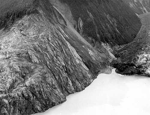
On July 9, 1958, the largest wave in modern history occurred in Lituya Bay, on the northern Southeast Alaska coast about halfway between Cape Spencer and Yakutat.

Initially, the wave - generated by a landslide that itself was generated by a massive earthquake that shook the region for more than a thousand miles up and down the coast - reached a height of more than 1,700 feet. It was still nearly 100 feet high when it reached the mouth of the bay seven miles later.

In its path were three small trolling boats taking advantage of the fact that Lituya Bay was the closest anchorage to the lucrative Fairweather fishing grounds offshore.

In fact, Lituya Bay is the only secure anchorage along more than 100 miles of Gulf of Alaska coast from just north of Cape Spencer to Yakutat. The entrance to Lituya Bay is extremely dangerous, and should only be attempted is short (10 to 20 minute) periods of slack water, according to the United States Coast Pilot book series.

Despite that challenge, the bay is often the refuge of choice when the weather gets bad along the coast.

Interestingly enough, the weather on July 9, 1958 was not the reason that three fishing vessels chose to anchor up in Lituya Bay.

According to one of the surviving fishermen, Howard Ulrich, it was a sunny day and the waters around the mouth of the bay were calm.

"Fishing had been poor on that memorable ninth day of July and I pulled my gear and headed the Edrie for Lituya Bay early in the evening," Ulrich told the Alaska Sportsman Magazine in an article for its October, 1958 issue. "all was smooth.it was a quiet and peaceful anchorage."

Two other boats joined the Edrie inside the bay, that night, the Badger and the Sunmore. But they chose an anchorage on the other side of the bay from the Edrie. When the wave came, two crews would survive and one crew would not.

A History of Big Waves

The unusual geology of Lituya Bay has lent itself to several large waves in the last 150 years.

The seven mile long, two mile wide bay has two large glaciers and several large mountains rising steeply from tidewater. It is only a few miles as the crow flies from tidewater to high mountains like Crillion (12,726 feet) and Fairweather (15,300 feet) making it a popular staging area for climbers. In fact, two groups of Canadian climbers narrowly missed being in the bay the night of July 9th. Had they been camped at tidewater as planned, the wave's death toll would have more than 20 rather than only two.


<span class=jpg Trees washed out and turned upslope by water at altitude of 1,720 feet." align="bottom" border="0" height="384" width="500">
Trees washed out and turned upslope by water at altitude of 1,720 feet. Small slides occurred on steep slope at right during the 1958 earthquake, but destruction of forest in middle and lower left part of view is due mainly to water. Lituya district, Alaska Gulf region, Alaska. Glacier Bay National Park and Preserve. Plate 7-A in U.S. Geological Survey.
Photograph courtesy U.S. Geological Survey


The weather also plays a role in the bay as it gets a large amount of precipitation - mostly rainfall. Some of the inland areas along the coast between Lituya Bay and Yakutat have had more than 300 inches of rain according to the National Weather Service and the winter and spring of 1958 was a wet one throughout Southeast Alaska. The ground in Lituya Bay - which frequently gets up to 150 inches of rain a year - was oversaturated even though it was sunny that July.

The third factor was the massive earthquakes that frequently topped 6 and 7 on Richter Scale in the area.

A final factor was the deep water - up to 800 feet - near the head of the bay. When earthquakes or other events caused landslides, they would displace large amounts of water sending it rushing toward the narrow mouth of the bay and the open ocean.

Federal geologist Don Miller was the foremost expert on Lituya Bay in the 1950s and the early 1960s. In his 1960 report, "Giant Waves in Lituya Bay Alaska." he pointed out evidence of five "giant" waves created primarily by land or glacier slides between 1853 and 1958.


<span class=jpg Lituya Bay, 1954, trimlines of the 1936 giant waves and the 1853-54 giant wave" align="bottom" border="0" height="397" width="500">
Aerial view of Lituya Bay, 1954, trimlines of the 1936 giant waves and the 1853-54 giant wave. Lateral moraines and the end moraine in the right and left foreground record a recent advance of ice to the mouth of the bay. Mount Crillon altitude 12,726 feet is the highest peak on the skyline. Lituya district, Alaska Gulf region, Alaska. September 16, 1954. Plate 3-A in U.S. Geological Survey.
Photograph courtesy U.S. Geological Survey


The 1853-54 wave was estimated at 395 feet, the 1874 wave at 80 feet, the 1899 wave at 200 feet, the 1936 wave at 490 feet and the 1958 behemoth swept trees off a hillside at more than 1,720 feet.

In addition to those giant waves, the waters of Lituya Bay had also been the site of several other disasters involving both the native Tlingit tribes and groups of American, British and French explorers and adventurers from the 1780s into the Twentieth Century, according to Philip Fradkin in his 2001 book "Wildest Alaska: Journeys of Great Peril in Lituya Bay."

Most of these involved the deadly, narrow entrance that featured tide rips and waters running up to 13 knots in either direction. Most notable was a disaster that cost French explorer Jean-Francois La Perouse more than 20 of his sailors. Fradkin also noted that Tlingit oral tradition featured several stories of "giant" waves and mass drownings in the bay.

Three Boats In the Bay

There were two commonly used anchorages near the mouth of Lituya Bay on that July night in 1958. Ulrich and his eight-year-old son "Sonny" chose to anchor about half a mile in from the mouth on the south side of the bay in place called, appropriately enough "Anchorage Cove."

Two other trolling boats, the Sunmore (with Orville and Mickey Wagner on board) and the Badger (operated by Bill and Vivian Swanson) anchored up on the opposite side of the bay, just behind the nearly mile long spit that extended most of the way across the mouth of the bay. The opening itself was less than 300 yards across and most of that water was too shallow for boats to cross. Some fishermen estimate there may less than 50 feet of open water at times.

The Ulrichs had anchored up just after 8 pm, while the other two boats - running partners who both lived in Juneau - anchored up around 9 pm.

Around 8 pm, a plane took off from near Cenotaph Island (so named after the drowning of the 20 French sailors in 1786). On board were 10 Canadians who had just returned from the first Canadian ascent of Mount Fairweather.


<span class=jpg Stump of living spruce tree broken off by the giant wave at Harbor Point, mouth of Lituya Bay" align="bottom" border="0" height="426" width="500">
Stump of living spruce tree broken off by the giant wave at Harbor Point, mouth of Lituya Bay. Brim of hat is 12 inches in diameter. Lituya district, Alaska Gulf region, Alaska. Plate 5-B in U.S. Geological Survey.
Photograph courtesy U.S. Geological Survey

"The expedition was scheduled to leave the following day, but the pilot of their Royal Canadian Air Force amphibian arrived at 6 pm that night and told them to pack immediately," Fradkin wrote in "Wildest Alaska." "He was worried about the possibility of fog and wanted to get the climbers back to Juneau that night. The climbers cursed the pilot's nervousness. They missed dinner in a hurry to pack and departed at 9 pm. Another party of climbers was due that day by boat but they had been delayedHad the two groups proceeded as planned, there would have been a total of 20 climbers camped on the shoreline that night."

Fradkin noted that the Canadian climbers weren't the only living things making a fortuitous getaway from the bay.

"As the Canadian climbers flew away, so did the nervous kittiwakes (that nested on the cliffs of Cenotaph Island)," Fradkin wrote. "The gulls ascended like so much confetti blown upward. The high intensity alarm call of thousands of birds echoed through the still bay. They passed over the Badger and splattered the boat with droppings. Some crashed into the vessel's rigging and plummeted to the deck. The Swansons were frightened."

Up and down the coast as far as Yakutat and Hoonah observers would report similar odd behavior by shore birds and other animals. Then, at approximately 10:16 pm, it happened.

"Cursing Myself For Not Moving Sooner"

The quake was later determined to be 8.3 on the earthquake scale and was centered 45 miles south of Lituya in Cross Sound. It was felt strongly as far south as Seattle and as far north as Anchorage. At Yakutat, 80 miles to the north of Lituya, three people out berry picking died instantly when a small island they were on immediately dropped more than two dozen feet under the water. Later measurements determined that a nearby mountain had risen more than 50 feet at the same time.

Overall, the earth had moved some 21 feet horizontally and 3.5 feet vertically along most of the fault line. While most earthquakes last only a few seconds, the initial length of the quake was later estimated at more than two minutes by Don Miller.

Then Lituya Bay got hit with the other shoe.

Miller - who was in Glacier Bay at the time of quake and flew to Lituya the next day - determined that less than two minutes after the initial tremor, the side of an unnamed 5,616 foot peak on the east side of Gilbert Inlet (at the head of the bay) plunged into the bay. At least 2,000 feet of rock fell.

"The noise was deafening," Fradkin wrote. "The violent impact of forty million cubic yards of rock, ice and coarse soil weighing ninety million tonswas heard 50 miles to the north. Ulrich said it sounded like an explosion."

With the first jolt, Bill Swanson tumbled out of his bunk on the Badger. He later told the Alaska Sportsman that the he could see even the highest mountains shaking. Then he saw the Lituya Glacier appear to literally rise up into the air.

"I know you can't ordinarily see that glacier from where I was anchored," he was quoted in the October, 1958 issue. "People shake their head when I tell them I saw it that night. I can't help it if they don't believe mebut I know what I saw that night."

From his vantage point, he could also see the mountainside slide away and crash towards the water. From his viewpoint on the other side of the bay, Ulrich could see the wave rise up and devastate the forested hillside.

All three boat crews had been woken up by the earthquake. But while the captains of the Badger and Edrie were transfixed by the spectacle at the head of the bay, the Wagners on the Sunmore jumped to immediate action and got their boat headed out of the bay.

It proved to be a fatal decision. Swanson reported seeing the Sunmore just about to turn out into the entrance when it was caught by the wave and flung over Harbor Point across the opening from the end of the spit. All that was found later was an oil slick marking the spot where the boat went down in deep water.

Ulrich told Alaska Sportsman that he was "petrified" by the landslide and the wave and didn't begin to act until he saw the wave, then still some 300 feet high engulf Cenotaph Island some two miles away from his boat.

"I began to move then," he said. "And I moved fast, cursing myself for not moving sooner."

" I Think We've Had It. Goodbye"

He got a life jacket on his son and started the engine. He started to pull the anchor and found it unmovable.

"The wave (then estimated at more than 75 feet high) was almost upon us and we were fastened to the bottom with a heavy chain," Ulrich said. He surmised that the quake had caused the anchor to get tangled on the bottom. He let out all his extra chain, in hopes that it would be enough to allow the boat to ride up and over the wave. Then he turned the boat into the wave and held on.


Southeast Alaska Earthquake, July 10, 1958. Wave damage on the south shore of Lituya Bay, from Harbor Point to the spur southwest of Crillon Inlet. August 9, 1958. Photos mdj01247 through mdj01261 form a sequence of fifteen photographs.
Photograph courtesy U.S. Geological Survey


"As the Edrie began her almost perpendicular ascent to the crest of the wave, the chain snapped," Ulrich said, adding that he wanted to get a message out so his wife in Pelican would eventually find out her husband and son had died. "There seemed to be no hope for survivalI grabbed the handset of my radiophone and yelled into it: 'Mayday! Mayday! This is the Edrie in in Lituya Bay. All hell has broken loose in hereI think we've had it. Goodbye.' "

But the luck that had abandoned the Wagners was still on Ulrich's side. At the top of wave, he regained enough control of his boat to hold on and steer around the debris being carried by the wave. A few seconds later, the worst had passed.

He sent out another message saying he thought they'd made it through. Immediately, other boats outside Lituya began radioing back. But, Ulrich noted, the silence from the Badger and the Sunmore was ominous.

Just about the time that Bill Swanson saw the wave engulf the Sunmore as it tried to escape, the wave - estimated to be approximately 80 feet high - hit his boat and carried it over the La Chaussee Spit and dumped it stern first into the open ocean.

"We went way over the trees and I looked down on rocks as big as an ordinary house as we crossed the spit," Swanson told the Alaska Sportsman. "We were way up above them. It felt like we were in a tin can and somebody was shaking it."

After the crash landing, the boat immediately began to sink. They were surrounded by acres of wood debris - including a large tree that smashed through the pilot house and broke several of Swanson's ribs - but managed to get into eight foot skiff with only their underclothes on, according to Fradkin's book. At nearly midnight, they were found by the crew of the vessel Lumen which was picking its way through the miles of debris looking for signs of survivors in the pitch dark.

After surviving the giant Lituya wave, Ulrich continued to fish but then quit the business a year later. As recently as 2004, he was still reliving the events of July 9, 1958. He wrote a brief story that appeared in Esquire magazine about that night under the title "What it Feels Like to Survive a Tsunami."

The Swansons eventually got a replacement boat, but Vivian - whose hair reportedly turned gray overnight after the Lituya incident - refused to go fishing with Bill again, according to Fradkin.

On the night of May 26, 1962. Bill Swanson returned to Lituya Bay for the first time since the wave in 1958. Shortly after passing through the narrow entrance to the bay, he suffered a massive heart attack and died.


WEATHER NOTE

LATEST ON FAY


Web makes it easy for stormchasers to track weather
ROBERT NOLIN

In ancient times, before the Internet ruled the world, folks needed pencil, straightedge and a rudimentary knowledge of latitude and longitude to track a storm like the wannabe tropical depression now knocking at the Caribbean's door.

No longer.

Now all an amateur storm chaser needs is a keyboard and mouse. In recent years, meteorological-based Web sites, including that of the U.S. government's own National Hurricane Center, have become sophisticated enough to drench even the most demanding weather buff with information.

"They've improved, they're faster, they have more information," said Scott Weiner, 41, who flicks on the computer when he hankers to follow a storm's progress. "The first place I go is the (South Florida) Sun Sentinel."

This newspaper's hurricane-related Web fixture, sunsentinel.com/hurricane, offers real-time storm tracking, a weather blog, satellite maps, storm histories and other features.

With an average of 38 million page views a month, the Weather Channel's Web site, weather.com, leads the pack in terms of popularity, according to Nielsen/NetRating. Users charting a storm don't want to wait for broadcast reports, site spokeswoman Melissa Medori said.

"I guess it's the usage pattern of 'I want it now. I don't want to have to wait for the next update,'" she said.

Rapid, frequent updates are indeed the draw for Weiner, as are fancy graphics and blogs. "I want to look at the maps, the projections," he said. "TV weather is useless."

If a storm is thrashing around the neighborhood, visits to weather Web sites spike.

"When there's any tropical storm or hurricane threatening land, especially U.S. soil, our traffic goes up approximately 50 percent," said Toby Skinner of The Weather Underground, the second-most popular site. "We talking such huge numbers we have to make plans to make sure our whole system doesn't break down."

Last month, when Hurricane Dolly barreled toward Texas, about 22 million visited wunderground.com in one day, Skinner said. "It's even more than we had with Katrina," he added, referring to the 2005 hurricane that wrecked New Orleans. "We're showing gradual increases year upon year."

Weather Web sites all use the same material from the National Hurricane Center in Miami-Dade County, but they customize maps, computer model tracks and snazzy graphics to enthrall viewers. Weather.com tosses in raw storm videos, photos and pet pictures. Another site, skeetobiteweather.com, prides itself on a more businesslike presentation.

The hurricane center has jazzed up its own site Web site to make it more layperson-friendly, said spokesman Dennis Feltgen. "We're in the 21st Century, we've got high-resolution graphics, we've taken the text piece and basically made it graphical."

The result, he said, has drawn 4 million page clicks to the site so far this year - not bad for a government venue. "They're clearly seeking the information out and they're quite savvy," Feltgen said of the mouse-wielding public.

But he cautioned that big decisions, such as when to shutter up or evacuate, should be left to professionals, and not armchair prognosticators.

"We certainly would not encourage them to make their own interpretation of track forecasts and intensity forecasts," he said. "We've got a number of scientists here at the center and that's what they're trained to do."

Hurricanes and climate change: A sharper view

August 13, 2008

In a study published in the July 2008 issue of Geophysical Research Letters, Drs. David S. Nolan and Eric D. Rappin from the University of Miami's Rosenstiel School of Marine and Atmospheric Science describe a new method for evaluating the frequency of hurricane formation in present and future tropical climates. While current thinking about changes in hurricane frequency comes mostly from computer simulations of global climate, the computer models used for these studies can only represent the coarsest features of hurricanes, thus casting doubt in their predictions of hurricane activity.

The new approach by Nolan and Rappin, developed in collaboration with Dr. Kerry Emanuel of the Massachusetts Institute of Technology, uses computer models with much more accurate representation of the processes that lead to hurricane formation, much the same way a digital image with more pixels allows for a more detailed photographic image. The models are used to simulate the rate of hurricane development in tropical atmospheres with varying values of sea surface temperature and vertical wind shear (which is the extent to which wind speed and direction changes with height in the atmosphere). These two variables - ocean temperature and wind shear -- are considered to be the two most important factors in predicting hurricane activity, both in operational forecasting and in consideration of climate change.

MARITIME NOTE

Riverdance ferry - a sorry sight


These pictures by Gazette photographer Bill Johnson show the pitiful remains of the wrecked Riverdance ferry – seven months after it ran aground off the Cleveleys coast.

What began as a huge tourist attraction – the sight of the beached vessel has brought thousands of trippers to the seafront – now looks more like a rusted shed as demolition teams have reduced it to a sorry sight.

Both engines have been removed from the 6,000 tonne ship and carted off to a spares company in the North East of England.

More than 34,000 litres of oil had to be taken off the stricken cargo ferry and other potential marine pollutants have also been removed. It will not be long before the wreck – which has been photographed by visitors from across the world since it became beached in heavy seas on January 31 – is completely removed.

Demolition experts from Hancock's Contractors Ltd and PGC Demolition Ltd have been working over the last two months to dismantle the ship piece by piece.

But it is painstaking and difficult work – depending on the weather and tidal patterns.

Fred Caygill, from the Maritime and Coastguard Agency, said: "The vessel has been stripped down internally, it's only the shell that remains.

"Sections are being cut off and the pieces being transported for recycling.

"The teams are making good progress and have done meticulous work.

"There is not a lot left of the ship now. All the work has been done without any loss or damage to the local environment.

"The work still remains on schedule, but we cannot give an exact completion date because it depends on the tides and the weather.

"But we are expecting the work to be completed around the end of September to early October."


RS