Wednesday, October 3, 2007

Cargo Ship Sinks During Storm

Search for survivors Cebu Daily News Last updated 02:17pm (Mla time) 10/03/2007

CEBU CITY, Philippines - Four survivors of an ill-fated cargo ship from Cebu that sank off Palawan are still in shock.

They could still hear their co-workers shouting for help while being eaten alive by sharks, a police official in Palawan said.

“Sabi nung mga survivors narinig pa nilang sumisigaw yung iba habang humihingi ng tulong. Nakita daw nila na kinakain na ng mga pating yung mga kasamahan nila. Pero wala silang magawa (The survivors said they heard the others screaming while asking for help. They said they saw their fellow seamen being eaten by the sharks but there was nothing they could do),” said Senior Superintendent Dennis Peña, Palawan police director.

The four were identified as chief mate Roulette Sapallida, seaman Rey Cabuhay, oiler Marlon Tiguman and apprentice Richard Abrigona, who were rescued by passing fishing boat Alister.

The survivors are now confined at the Cuyo District Hospital in Cuyo town, Palawan.

Because of this account of the survivors, Peña said most of the 14 missing crew members of M/V Mia of JPS Shipping Lines in Cebu could already be dead.

But, he added, they have not given up hope.

Divers and rescue swimmers of the Philippine Coast Guard continued their search in the hope of finding more survivors.

The Maritime Industry Authority in Central Visayas (Marina-7) has started its investigation into the sinking of the cargo vessel about 28 nautical miles southwest off Cagayancillo, Palawan.

Mardon Martin, Marina-7 safety engineer, said the probe would determine if the shipping corporation could be liable for the incident or there was negligence on the part of the crew members.

The M/V Mia, loaded with 880 metric tons of cement, left San Fernando town in southern Cebu about 5 a.m. of September 27. It was expected to arrive in Brooke's Point, Palawan on September 29.

Based on the marine protest filed by JPS general manager Gallagher Gallarde to Marina-7, the vessel sank about 11 p.m. on September 28.

Report from the Philippine Coast Guard (PCG) in Manila, however, said M/V Mia went under about 4 p.m. on September 29 reportedly due to bad weather.

But according to the Palawan police, the vessel overturned after the enormous waves spawned by typhoon Hanna damaged its body while it was crossing the sea off Cagayancillo about 2:40 p.m. on Sunday.

The vessel tilted to its side and the overturned, the report from the Palawan police said.

According to Gallarde in his marine protest, the JPS shipping personnel received a radio message from the M/V Mia crew members about 1 p.m. on September 28 that the cargo vessel was already 20 miles off Tubbataha Reef, off Puerto Princesa City, Palawan.

The crew members also told the shipping lines that their estimated time of arrival in Brooke's Point would be delayed by seven hours — from 6 a.m. to 1 p.m. on September 29 — due to rough seas.

“This was the last radio communication from the crew of M/V Mia; hence, there was neither radio contact nor cellular phone communication from September 29, 30 and October 1 except from the fishing boat Alister at 8:10 a.m. on October 1,” according to the marine protest.

Gallarde said in the marine protest that representatives from the fishing boat informed JPS Shipping through radio on October 1 that they were able to rescue four of the 18 crew members.

The fishing boat happened to pass by and saw what happened.

The crew men of F/B Allister daringly plucked the four survivors from the rough seas, according to Peña of the Palawan police.

Peña said the Palawan police were also conducting an investigation to check into the possibility that the sunken cargo ship might be overloaded.

The sinking of M/V Mia was the second sea tragedy in Palawan in September.

Martin of Marina-7 said the Philippine Coast Guard would convene the Special Board of Marine Inquiry to look into the cause of the sinking.

Marina would also check if the vessel was seaworthy when it sailed to Brooke's Point, he added.

Martin said they would also verify if the vessel had proper life-saving equipment on board such as life-jackets and that all crew members had the proper papers.

To determine these, he said Marina officials would interview the survivors.

But Martin said there was no reason to ground the two other vessels of JPS Shipping Corp.

“If there are administrative lapses, we can impose a fine or suspend the certificate of public convenience of the shipping company”, he said.

In the meantime, the Coast Guard continues its search for missing crewmen.

Lieutenant Armand Balilo, PCG spokesperson, said the rescue team's operations were hampered by the incessant rains brought about by tropical storm “Ineng.”

“But rest assured that our search and rescue operations will not cease until we find the missing persons,” he said. /Correspondent Jhunnex Napallacan and Inquirer

Note: I have to tell you how disguested I am with the reporting of this event. 90% of the copy on this story is conflicting or just badly reported. To you reporters out there. What was the name of the storm that did the damage to this ship? Come on sheesh .....
Additional Stories...
Cebu Daily News
Inquirer.net, Philippines - 13 hours ago
CEBU CITY, Philippines - Four survivors of an ill-fated cargo ship from Cebu that sank off Palawan are still in shock. They could still hear their ...
Crew of sunken ship feared eaten by sharks
China Daily, China - 13 hours ago
Manila -- Fourteen crew members of a cargo ship which sank in waters off western Philippines' Palawan Island last weekend were believed to have been eaten ...
Four missing sailors eaten by sharks in Palawan
ABS CBN News, Philippines - 14 hours ago
Four of fourteen missing sailors were eaten by sharks after their cargo vessel sank off waters in Palawan over the weekend, the Philippine Coast Guard said ...
Sharks mangled crewmen of sunken ship off Palawan--survivors
Inquirer.net, Philippines - Oct 2, 2007
By Marlon Ramos CAMP VICENTE LIM, Laguna, Philippines -- Four of the rescued crewmembers of a cargo ship which sank off the coast of Cagayancillo, ...
14 missing after Philippine ship sinks in stormy waters
International Herald Tribune, France - Oct 2, 2007
AP MANILA, Philippines: A cargo ship sank in stormy waters in the southwestern Philippines, leaving 14 crew members missing, the coast guard said Tuesday. ...
14 crew missing after cargo vessel sinks off Palawan
Inquirer.net, Philippines - Oct 1, 2007
MANILA, Philippines -- Four of the 18 crew of a cargo vessel were rescued after their ship sank off the coast of Palawan province last Sept. ...
14 missing seamen now feared dead in Palawan
Manila Times, Philippines - 5 hours ago
PUERTO PRINCESA CITY: The 14 missing officers and crew of a Cebu-based cargo vessel that sank off Palawan waters over the weekend are feared dead. ...
Fourteen crew missing after cargo ship sinks in Philippines
Monsters and Critics.com, UK - Oct 2, 2007
Manila - Fourteen crew members are missing after a cargo ship carrying cement sank in stormy seas on the weekend in the western Philippines, the coast guard ...
Cargo ship sinks in the Philippines Gulf News, United Arab Emirates - Oct 2, 2007 Manila: At least 14 crew members were missing after a Philippine ship carrying 800 tonnes of cement sank off a western island, the coast guard said on ...


Special Notes Of The Day!

October 4th is the Feast Day of St. Francis of Assisi!

Saint Francis of Assisi (September 26, 1181 - October 3, 1226) was a Roman Catholic friar and the founder of the Order of Friars Minor, more commonly known as the Franciscans.

He is known as the patron saint of animals, birds, and the environment, and it is customary for Catholic churches, rescues and shelters, and animal community organizations to hold ceremonies honoring animals around his feast day of October 4.


RS

Deep Dive has a Whole New Meaning

Deep Dive has a Whole New Meaning

Posted by: Conversation Agent

Robert_ballard_ocean_explorer I love the sea and for a time had the fortune of sailing on the ocean in Newport, RI, one of the capitals of New England charm for many reasons, one of which is its people. I find that people who live close to the sea tend to have a fluid quality to them that agrees with me.

Acclaimed ocean explorer Robert Ballard made that same impression on me last night. Dr. Ballard is also professor of oceanography and currently serves as Director of the Institute for Archaeological Oceanography, at the University of Rhode Island's Graduate School of Oceanography. That is archeology of the deep sea, where the sun light never shines -- a new discipline he helped found.

Last night, he kicked off the 2007-2008 Philadelphia Speakers Series with a deep dive into the mysteries of the ocean. An explorer-in-residence of the National Geographic, Mr. Ballard discovered the Titanic or rather its wreck in 1985 while on his way to a far more secret mission since declassified. He then went on a discovery binge, finding the Bismarck, the Lusitania and other ships lost at sea, eventually going back to the RMS Titanic 19 years later with the aid of new technology, including improved robotic subs, high-definition cameras and better lighting to see the remains in much greater detail. Yes, Director James Cameron consulted with him through the making of the movie.

Dr. Ballard is about to immerse himself again in an exploration of the Aegean and Black Seas -- waterways that have served as major trade routes for centuries to discover the mysteries that lie underneath. According to the Science Daily:

Shipwrecks in the Black Sea often are remarkably well-preserved due to the waterway's chemistry. Nearly 90 percent of the Black Sea is a no-oxygen “dead zone,” where only a few bacteria live.

What did he learn about life in the depths of the ocean? The largest mountain range on earth is located underwater -- the Mid-Atlantic Ridge extends for 42,000 continuous miles with tens of thousands of active volcanoes. If you're curious as I am about this sort of thing, you will be intrigued to learn that 72% of our planet is beneath the sea and in total darkness. We live on the remaining 18%. In fact, some of Dr. Ballard's greatest discoveries do not involve ship wrecks, they are about life.

  • In 1977, while exploring in the submersible ALVIN near the Galapagos Islands (in the Pacific Ocean off the coast of Ecuador), Dr. Ballard and J. F. Grassle, on Project FAMOUS, discovered giant worms (called Riftia) and other organisms living deep in the sea, beyond the depth where people though that life could be sustained. These huge worms were clustered around underwater hot springs (near ocean rifts) from which they get energy. The underwater vents substitute for the Sun's energy. The worms grow in long tubes and are over 10 feet (3 meters) long.
  • In 1979, Dr. Ballard found deep water volcanoes called "black smokers" located off the coast of Baja California in the Pacific Rise; they spew extremely hot mineral-rich water up chimneys formed by mineral deposits (it is so hot that it could melt lead).
  • The water of the earth's oceans is cycled through the earth's crust, changing its mineral composition in the process. The water goes down through cracks in the crust until it hits very hot rock where it becomes superheated and dissolves minerals from the rocks. Then it shoots upward through the vents. This explains why sea water contains the minerals it does (this was unexplained by previous theories).
  • The plates from our planet's crust are constantly ripping open and bleeding lava. Most of the earth is generated through lava force in a continuous process of genesis. This also explains the regenerative power of the earth. Our planet has a regular face lift!

Ballard More modern-day Captain Nemo than The Old Man and The Sea, after receiving a tremendous amount of mail from children about the Titanic adventure, Dr. Ballard founded the JASON Foundation for Education in 1989. The JASON project is named for Jason, the mythical Greek explorer who sailed the seas in a ship named "Argo" in order to find the golden fleece.

This project lets children learn about and follow global deep sea exploration. A Remotely Operated Vehicle (ROV) called Jason is sent to explore the sea down to 20,000 feet, and Jason's video signals are broadcast live via two-way satellite to students in schools and museums around the world. "All kids dream a marvelous image of what they want to do. But then society tells them they can't do it. I didn't listen. I wanted to live my dream," he said.

My favorite quote -- "If you can plan it out and it seems logical to you, then you can do it. I discovered the power of a plan."

Maritime Notes:


Life on the North Sea!

RS

Tuesday, October 2, 2007

NOAA MISSION TO AQUARIUS

NOAA MISSION TO AQUARIUS UNDERWATER HABITAT TO STUDY IMPERILED REEFS IN FLORIDA KEYS NATIONAL MARINE SANCTUARY

NOAA image of the Aquarius undersea lab. Located 63 feet below the surface in Florida Keys National Marine Sanctuary, it will serve as the base for a nine-day mission to study corals and marine life. Please credit “NOAA.”September 12, 2007 — Scientists and educators from NOAA’s National Marine Sanctuary Program will embark on a nine-day mission to the world’s only undersea scientific facility starting Sept. 17. (Click NOAA image for larger view of the Aquarius undersea lab. Located 63 feet below the surface in Florida Keys National Marine Sanctuary, it will serve as the base for a nine-day mission to study corals and marine life. Click here for high resolution version. Please credit “NOAA.”)

While living underwater in the Aquarius ocean laboratory, scientists will investigate changes to corals and marine life in Florida Keys National Marine Sanctuary and broadcast their activities in real time to students and general audiences via the OceansLive.org education Web portal.

During the mission, dubbed “Aquarius 2007: If Reefs Could Talk,” scientists will conduct research mainly on sponge biology and ecology and long-term monitoring of coral and fish species. Mission results will be compared with previously collected data, going back to 1994, to assess change on the reef, which may be due to anthropogenic climate change and associated natural variability, as well as human contributions in the form of pollution. The mission will use advanced technology for underwater research combined with communications to create and broadcast web-based educational programming.

NOAA image of a scuba-diving researcher investigating changes to corals in the Florida Keys National Marine Sanctuary. Starting Sept. 17, this work will be broadcast to students and general audiences via the Internet. Please credit “NOAA.”“Six aquanauts will be living and working in a state-of-the-art undersea facility for an extended time to test new equipment, learn new things about what makes reefs healthy, and update long-term data to measure what’s happening to the reef ecosystem in the Florida Keys,” said Steve Gittings, national science coordinator for the National Marine Sanctuary Program and lead scientist for the mission. “The findings will help us all better protect our fragile ecosystems for future generations.” (Click NOAA image for a larger view of a scuba-diving researcher investigating changes to corals in the Florida Keys National Marine Sanctuary. Starting Sept. 17, this work will be broadcast to students and general audiences via the Internet. Click here for high resolution version. Please credit “NOAA.”)

Located nine miles southeast of Key Largo, Fla., in Florida Keys National Marine Sanctuary, Aquarius lies 60 feet below the surface at the base of Conch Reef. The undersea research station is nine feet in diameter, 43 feet long, and can support diving to depths of 120 feet. The six aquanauts will live in Aquarius for nine days supported by a shore-based crew on watch around the clock. Real-time video, audio, and Internet feeds will provide high-resolution communications and an exciting virtual experience for the public, educators, and students.

Aquarius is owned by NOAA, administered through NOAA’s National Undersea Research Program, and operated by the University of North Carolina Wilmington’s National Undersea Research Center.

NOAA image of the Aquarius undersea lab. Located 63 feet below the surface in Florida Keys National Marine Sanctuary, it will serve as the base for a nine-day mission to study corals and marine life. Please credit “NOAA.”“We are thrilled to join forces with the National Marine Sanctuary Program during this exciting mission to better understand and assess change on our threatened coral reefs and to bring the wonders of underwater living and science to students through the Web,” said Ellen Prager, chief scientist for Aquarius Reef Base. (Click NOAA image for larger view of the Aquarius undersea lab. Located 63 feet below the surface in Florida Keys National Marine Sanctuary, it will serve as the base for a nine-day mission to study corals and marine life. Click here for high resolution version. Please credit “NOAA.”)

NOAA's National Marine Sanctuary Program seeks to increase the public awareness of America's marine resources and maritime heritage by conducting scientific research, monitoring, exploration and educational programs. Today, the sanctuary program manages 13 national marine sanctuaries and one marine national monument that together encompass more than 150,000 square miles of America's ocean and Great Lakes natural and cultural resources.

NOAA, an agency of the U.S. Commerce Department, is celebrating 200 years of science and service to the nation. From the establishment of the Survey of the Coast in 1807 by Thomas Jefferson to the formation of the Weather Bureau and the Commission of Fish and Fisheries in the 1870s, much of America's scientific heritage is rooted in NOAA.

NOAA is dedicated to enhancing economic security and national safety through the prediction and research of weather and climate-related events and information service delivery for transportation, and by providing environmental stewardship of our nation's coastal and marine resources. Through the emerging Global Earth Observation System of Systems (GEOS) NOAA is working with its federal partners, more than 70 countries and the European Commission to develop a global monitoring network that is as integrated as the planet it observes, predicts and protects.

Weather Story

3 Day Forecast Track

We have Tropical Depression Juliette blowing out in the Pacific off the coast of California. Current movement is North-Northwest or 340 degrees at 8kt. Estimated pressure 1006mb, substained winds 25kt with gusts to 35kt.

Storms on the Atlantic side all fell apart.


RS


Monday, October 1, 2007

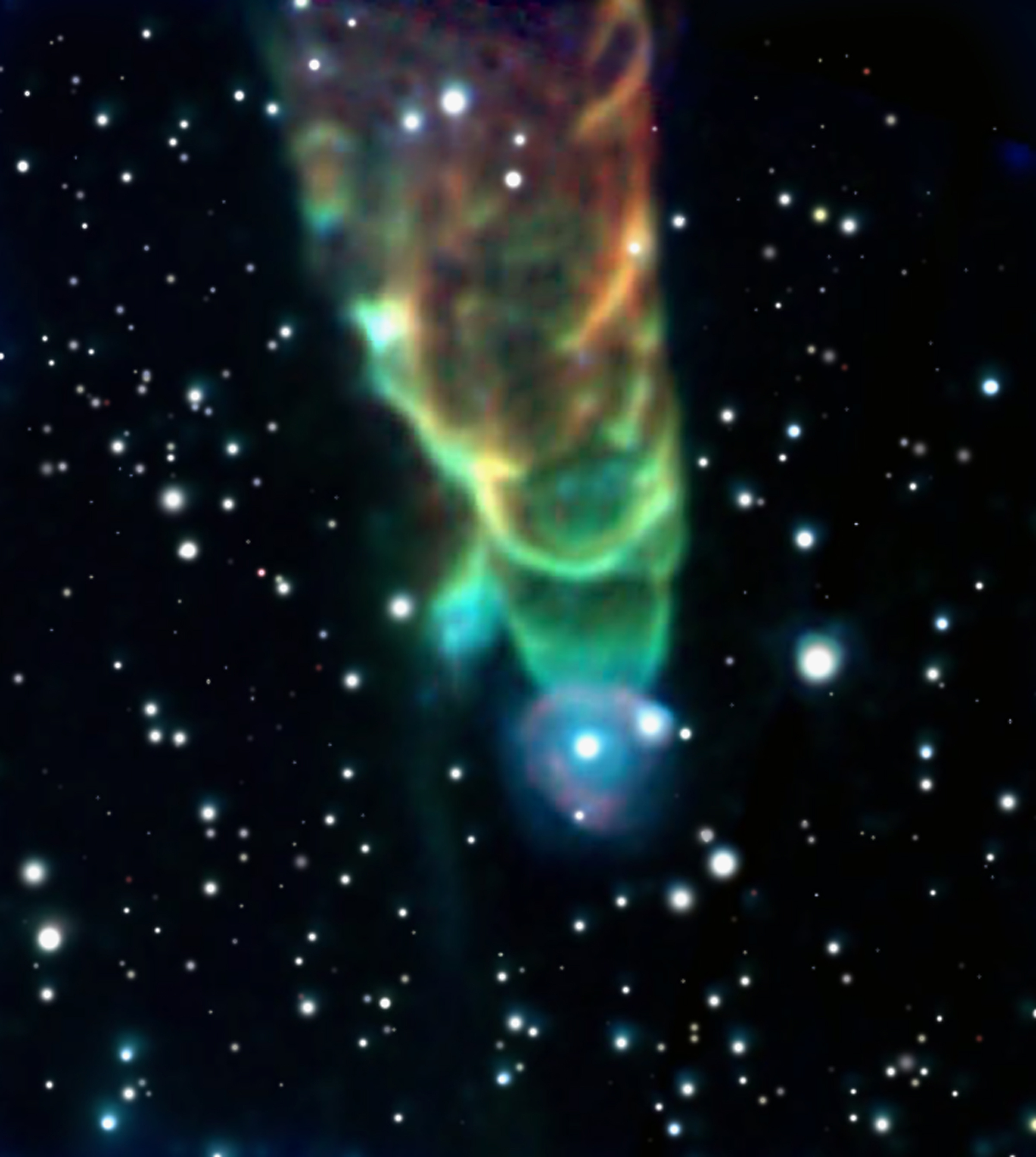
Cosmic Tornado

Cosmic Tornado HH49/50 Credit: J. Bally (Univ. of Colorado) et al., JPL-Caltech, NASA

Explanation: Light-years in length, this cosmic tornado is actually a powerful jet cataloged as HH (Herbig-Haro) 49/50 blasting down from the top of a Spitzer Space Telescope view. Though such energetic outflows are well known to be associated with the formation of young stars, the exact cause of the spiraling structures apparent in this case is still mysterious. The embryonic star responsible for the 100-kilometer per second jet is located just off the top of the picture, while the bright star seen near the tip of the jet may just by chance lie along the line of sight. In the false-color infrared image, the tornado glows with infrared light generated as the outflow heats surrounding dust clouds. The color coding shows a trend from red to blue hues at the tornado's tip indicating a systematic increase in emission at shorter wavelengths. The trend is thought to indicate an increase in molecular excitation closer to where the head of the jet is impacting interstellar gas. HH49/50 is about 450 light-years distant, located in the Chamaeleon I molecular cloud.


Weather Story


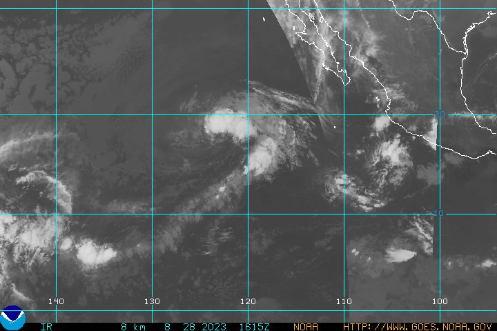
The National Hurricane Center is watching three storms in the Atlantic Ocean, but none is expected to intensify significantly right now. latest goes west infra red hurricane image

Tropical Storm Juliette formed in the Pacific Ocean off Mexico and was forecast to whirl along off the Baja California peninsula over the next few days, the U.S. National Hurricane Center said on Sunday.

Juliette was carrying maximum sustained winds of 45 mph (72 kph) and was more than 350 miles southwest of the peninsula.

The center described Juliette as a "weaker storm" that could lose force as it hit cooler waters.

Maritime Notes:


A sampling of videos and photos found on the popular maritime and ocean related social website. Yachts yacht super yacht boats boat boating ships mega yacht sinking crash coast guard uscg navy military scuba water ski wake boarding kite surfing titanic beach wreck crash sink sunk blunder crash accident casualty casualties.

Provided By: splashvisionCom


RS

Friday, September 28, 2007

THE DEADLIEST, COSTLIEST, AND MOST INTENSE UNITED STATES TROPICAL CYCLONES

NOAA Technical Memorandum NWS TPC-5

THE DEADLIEST, COSTLIEST, AND MOST INTENSE UNITED STATES TROPICAL CYCLONES FROM 1851 TO 2006 (AND OTHER FREQUENTLY REQUESTED HURRICANE FACTS)


Updated 15 April 2007 for return period information Eric S. Blake Edward N. Rappaport Christopher W. Landsea NHC Miami National Weather Service National Hurricane Center Miami, Florida April 2007

PREFACE
This version of the Deadliest, Costliest, and Most Intense United States Tropical Cyclones extends the work of Blake et al. (2005) to include 2005 and 2006. New updates include revised hurricane landfall intensity data from the period 1851-1914, categorized inland hurricane impacts, new major hurricane statistics, an updated assessment of the impact from Helene (1958), and a new estimate of the deaths caused by Audrey in 1957. The technical memorandum also uses a revised methodology (Pielke et al. 2007) to produce an estimate of the monetary loss that historical hurricanes could exact on the current property-at-risk in the same location.

THE DEADLIEST, COSTLIEST, AND MOST INTENSE UNITED STATES TROPICAL CYCLONES FROM 1851 TO 2006 (AND OTHER FREQUENTLY REQUESTED HURRICANE FACTS) by Eric S. Blake, Edward N. Rappaport, and Christopher W. Landsea
NOAA/NWS/NCEP/TPC/National Hurricane Center Miami, Florida

ABSTRACT
This technical memorandum lists the deadliest tropical cyclones in the United States during 1851-2006 and the costliest tropical cyclones in the United States during 1900-2006. The compilation ranks damage, as expressed by monetary losses, in three ways: 1) contemporary estimates; 2) contemporary estimates adjusted by inflation to 2006 dollars; and 3) contemporary estimates adjusted for inflation and the growth of population and personal wealth (Pielke et al. 2007) to 2006 dollars. In addition, the most intense (i.e., major1 ) hurricanes to make landfall in the United States during the 156-year period are listed. Some additional statistics on United States hurricanes of this and previous centuries, and tropical cyclones in general, are also presented.

1. INTRODUCTION


The staff of the National Hurricane Center receives numerous requests for statistical information on deaths and damages incurred during tropical cyclones affecting the United States. Information about their intensity is also frequently of interest. Estimates of these measures vary in the literature. Our hope is to present the best compilation of currently available estimates. In some instances, data in our lists represent revised estimates based on more complete information received following earlier publications including previous versions of this technical memorandum.
There are other frequently asked questions about hurricanes, such as: What is the average number of hurricanes per year? Which year(s) had the most and least hurricanes? Which hurricane had the longest life? On what date did the earliest and latest hurricane occur? What was the most intense Atlantic hurricane? What was the largest number of hurricanes in existence on the same day? When was the last time a major hurricane or any hurricane impacted a given community? Answers to these and several other questions are provided in Section 3.

2. BACKGROUND AND DEFINITIONS


Many of the statistics in this publication depend directly on the criteria used in preparing another study, “Hurricane Experience Levels of Coastal County PopulationsTexas to Maine” [(Jarrell et al. 1992)]. The primary purpose of that study was to demonstrate, county by county, the low hurricane experience level of a large majority of the population. Statistics show that the largest loss of life and property occur in locations experiencing the core of a category 3 or stronger hurricane.
The Saffir/Simpson Hurricane Scale (SSHS, Table 1) provides wind, associated central pressure, and storm surge values.

There is not a one-to-one relationship between these elements and it is important to note that the original SSHS category assignment was based on a combination of these elements (Hebert and Taylor 1975). Since about 1990, however, the NHC has assigned the SSHS category by using the maximum one-minute wind speed value only. Thus there is an inconsistency in the HURDAT database (Jarvinen et al. 1984) that will be rectified as the Atlantic best-track reanalysis project is completed (Landsea et al. 2004b).

Currently, the SSHS category assignment is based on wind speed from 1851-1914 and 1990-2006 and on a combination of wind, pressure and storm surge from 1915-1989. Heavy rainfall associated with a hurricane is not one of the criteria for categorizing.
Dvorak satellite intensity estimates are often the only estimate of the wind. Available surface wind reports, surface estimates of wind from passive/active microwave satellites, aircraft reconnaissance flight-level winds (from which surface wind speed can be estimated), and dropsonde data occasionally supplement these wind estimates. In post-storm analysis, the central pressure ranges of hurricanes on the SSHS will usually agree fairly well with the wind ranges for each category. On the other hand, the storm surge is strongly dependent on the slope of the continental shelf (shoaling factor). This can change the height of the surge by a factor of two for a given central pressure and/or maximum wind.

The process of assigning a category number to a hurricane in any location is subjective, as is NHC’s estimate of a cyclone’s impact . It is made on a county-by-county basis. In this study, we use criteria for direct hit as described in the work by Jarrell et al. (1992). Note we are discontinuing the use of the term indirect hit because of the lack of local information that is conveyed in that language.
Direct Hit Using "R" as the radius of maximum winds in a hurricane (the distance in miles from the storm's center to the circle of maximum winds around the center), all or parts of coastal counties falling within approximately 2R to the right and R to the left of a storm's track were considered to have received a direct hit. (This assumes an observer at sea looking toward the shore. If there was no landfall, the closest point of approach was used in place of the landfall point). On average, this direct hit zone extended about 50 miles along the coastline (R≈15 miles).

Of course, some hurricanes were smaller than this and some, particularly at higher latitudes, were much larger. Cases were judged individually, and many borderline situations had to be resolved.
In this document, the term strike is designated to mean one of two things: During the years 1851-1914 and 1990 to 2006, a hurricane strike is defined as a hurricane that is estimated to have caused sustained hurricane-force winds on the coastline, but does not necessarily make landfall in the area of hurricane-force winds. One example of a hurricane strike is Hurricane Ophelia in 2005, which remained offshore of the North Carolina coast but still brought sustained hurricane-force winds to the coastline. During the years 1915 to 1989, a hurricane strike is defined as a hurricane whose center passes within the direct hit definition area provided above. The best-track reanalysis project is working to change the definition to be strictly defined by the winds, but for now the regional effects catalogued by HURDAT are in a transition period that could last several more years.

Statistics on tropical storm and hurricane activity in the North Atlantic Ocean (which includes the Gulf of Mexico and the Caribbean Sea) can be found in Neumann et al. (1999). A stratification of hurricanes by category which have affected coastal counties of the Gulf of Mexico and North Atlantic Ocean can be found in Jarrell et al. (1992) and also at the NOAA Coastal Services Center (http://hurricane.csc.noaa.gov/hurricanes/index.htm). Additional information about the impact of hurricanes can be found in annual hurricane season articles in Monthly Weather Review, Storm Data and Mariner’s Weather Log.
A new feature for this update is including the inland impacts of some hurricanes. These cyclones are indicated with an “I” before the state abbreviation in the HURDAT database and are exclusively used for hurricane impacts that are felt in a state, but not at the coastal areas. One example of this occurrence is Hurricane Dennis (2005). After landfall, Dennis produced category one hurricane winds over inland areas of Alabama, but these effects were not felt along the coast of Alabama. Thus an “I” is added in front of the state designation, to be IAL 1. If a hurricane primarily impacts the coastal areas of a state, inland effects are not listed separately. The goal of this listing is to indicate only the most significant impact of that state. Because of the geography of Florida, any effects in the state are considered coastal.

Read the rest of the report
THE DEADLIEST, COSTLIEST, AND MOST INTENSE UNITED STATES TROPICAL CYCLONES

Weather Story

USA. Scientists and beach managers to present at Lake Michigan, Great Lakes conferences in Traverse City

Experts will discuss Lake Michigan and Great Lakes beaches at concurrent conferences in Traverse City, Mich., Oct. 3 to 5. Scientists and beach managers will present the latest research on sustainability and environmental issues affecting the lake, Grand Traverse Bay and Great Lakes beaches.

Topics include the potential impact of climate change on Lake Michigan, economics of a healthy lake, fisheries, invasive species, recovering species, viral hemorrhagic septicemia, and health risks at beaches. The keynote speaker is John Austin, lead author of the recent Brookings Institution report "Healthy Waters, Strong Economy: the Benefits of Restoring the Great Lakes Ecosystem."
This is the fifth biennial State of Lake Michigan Conference and at each conference new information and reports have been presented about changes in the lake.
The conferences will be held at the Hagerty Conference Center, Northwestern Michigan College - Great Lakes Campus and the Holiday Inn - West, Traverse City.

Reporters are invited to attend any of the sessions. To request an interview with conference organizers or presenters, call Phillippa Cannon, EPA, or Mark Breederland, Michigan Sea Grant, at the numbers below.
The State of Lake Michigan and Great Lakes Beach conferences are sponsored by EPA Great Lakes National Program Office, the Lake Michigan Forum, Michigan Sea Grant College Program, the Great Lakes Beach Association and the Great Lakes Regional Research Information Network.

Tropical Weather Outlook

Atlantic/Caribbean/Gulf of Mexico:
Tropical Storm Lorenzo

At 4:00 am CDT, September 28, 2007, the government of Mexico has changed the Hurricane warning from Palma Sola to Cabo Rojo to a Tropical Storm Warning.

A Tropical Storm Warning is now in effect from Veracruz northward to Cabo Rojo. The Tropical Storm Watch from north of Cabo Rojo to La Cruz has been discontinued.

At 4:00 am CDT, September 28, 2007, the center of Tropical Storm Lorenzo was located about 30 miles south-southwest of Tuxpan, Mexico.

TS Lorenzo is moving toward the west near 7 mph. A motion toward the west-northwest is expected today, which will bring TS Lorenzo farther inland over east-central Mexico.

The center of TS Lorenzo made landfall at about 12:00 am CDT, September 28, 2007, about 40 miles south-southeast of Tuxpan, Mexico.

Maximum sustained winds are near 65 mph, with higher gusts. Rapid weakening is forecast today as TS Lorenzo proceeds inland, and this small system will likely become a Tropical Depression later today and dissipate by tonight or early tomorrow.

Tropical Storm force winds extend outward up to 45 miles from the center.

Estimated minimum central pressure is 995 mb (29.38 inches).

Storm surge flooding of two-to-four feet above normal tide levels, along with large and dangerous battering waves, is expected near and to the north of where the center has made landfall. Tide levels should return to near normal later today or tonight.

TS Lorenzo is expected to produce total rainfall accumulations of five-to-10 inches, with possible isolated maximum amounts of 15 inches over portions of east-central Mexico.

These rains could cause life-threatening flash floods and mud slides.

Elsewhere, tropical cyclone formation is not expected during the next 48 hours.

Tropical Storm Karen
At 5:00 am EDT, September 28, 2007, the center of Tropical Storm Karen was located about 755 miles east of the Windward Islands.

TS Karen is moving toward the west-northwest near 10 mph, and this motion is expected to continue for the next 24 hours.

Maximum sustained winds have decreased to near 45 mph, with higher gusts. Some additional weakening is possible during the next 24 hours due to strong upper-level winds.

Tropical storm force winds extend outward up to 150 miles, mainly to the east from the center.

The five day track projection keeps the center on a fairly straight northwesterly track, about 1,000 miles to the east of San Juan, PR and by Tuesday, October 2, 2007, approximately 1,000 miles east-southeast of Bermuda.

A tropical wave southwest of the Cape Verde islands is generating intermittent shower and thunderstorm activity. Development, if any, is expected to be slow to occur.

Elsewhere, tropical cyclone formation is not expected during the next 48 hours.

Eastern Pacific:
The area of low pressure located about 325 miles south-southwest of Manzanillo, Mexico, continues to show signs of organization.

Environmental conditions appear favorable for additional development, and this system could become a Tropical Depression within the next day or two as it moves toward the west-northwest.

Elsewhere...tropical cyclone formation is not expected during the next 48 hours.

Central Pacific:
Nothing to report.

Western Pacific:
The Joint Typhoon Warning Center (JTWC) has issued a Tropical Cyclone Formation Alert (TCFA) for the area of convection approximately 470 nm east of Manila, Philippines. Conditions will allow for convective development to increase. (NOAA, National Hurricane Center, Central Pacific Hurricane Center and the Joint Typhoon Warning Center)

African Situation

AFRICA (24 Sep.) A state of emergency was declared in the worst flood-affected areas as humanitarian workers tried to reach villages that have been cut off by water. Aid agencies have started appealing for funds to assist people hit by the floods in several African countries. UN agencies are seeking $43m for Uganda, where the government declared an emergency after 50 people died. The International Red Cross has sent relief experts to the continent to raise money and deal with emergencies in Ghana and Togo, as well as Uganda. 1.5m people are affected by the floods.

Maritime Notes:

Attached is the latest Notice to Mariners Published by the National Geospatial-Intelligence Agency. The notice transmitted is listed on the Maritime Safety Information (MSI) Website in the "Notice to Mariners" section as "Entire NtM". Graphics provided in this version are inadequate for navigation purposes. Navigation-quality chartlets are available for download on the MSI website as needed. Below is the link to the Notice to Mariners Web Page: http://www.nga.mil/maritime/

IMO – World Maritime Day

The IMO issued a news release in commemoration of World Maritime Day. The theme for this year’s event is IMO’s response to current environmental challenges. Secretary-General Mitropoulos pointed out that the maritime industry is a vital segment of the world economy and that the industry must do its part to protect the environment. (9/27/07).

Sinking of the ferry ESTONIA

On September 28, 1994, the ferry ESTONIA sank during a storm in the Baltic Sea. The sinking claimed 852 lives and the exact cause remains controversial. The ferry was engaged in an overnight crossing from Tallinn to Stockholm, carrying 989 passengers and crew. The official report states that the bow visor broke under the strain of the heavy weather, allowing large quantities of water to enter the car deck. The free-surface effect of the water on the open deck caused the ferry to list and rapidly sink. A variety of safety improvements were adopted subsequent to this incident.

RS

Thursday, September 27, 2007

The Ten Scariest Weather Scenarios

The Ten Scariest Weather Scenarios

Almost a month before Halloween is upon us again, so why not start a series of “world’s scariest” posts. Personally, things that scare me are things beyond my control. Take the weather, for example. Mother Nature can at once be both breathtaking beautiful and unspeakably terrifying (see tornado). Let’s run with the latter and examine the ten scariest weather scenarios…

10. The Northern Lights

Okay, so may be this is not a “weather event,” per se. But it’s an atmospheric phenomenon, so it’s close enough. It involves solar radiation and electrically charged particles and physics and what not. Contrary to popular belief, the lights can be seen throughout the United States depending on the conditions. One thing is for sure: If I walked out my door, glanced up at the sky and I saw what’s in that pic above, I would be seriously freaked out.

9. Ice storms

Little about winter weather is really that scary, but ice storms are the exception. Unpredictable, hard to forecast, devestatingly destructive, ice storms are among nature’s cruelest storms. The power company is never amused when one threatens. It has also led to the setting of, like, three Stephen King novels.

8. Raining animals

Some times, it literally rain’s cats and dogs. Well, fish at least. Some times, when especially power storms cross large bodies of water, updrafts and waterspouts can literally extract fish from the water, toss them into the atmosphere and rain them back down onto dry land. Again, if I walk out of my house and into a downpour of fish, I’m freakin’ out.

7. Derechos

From Wikipedia, a derecho is a widespread and long-lived, violent convectively induced windstorm that is associated with a fast-moving band of severe thunderstorms usually taking the form of a bow echo. Derechos are usually not associated with a cold front, but a stationary front within a highly buoyant, warm airmass. A warm weather phenomenon, derechos occur mostly in summer, especially July (in the northern hemisphere), but can occur at any time of the year and occur as frequently at night as in the daylight hours.

In other words, it’s a fast-moving, long-traveling, devastating wind that you can see coming at you on radar, but there’s nothing you can do about it. They produce widespread damage similar to that of tornadoes.

6. Gust fronts/Sand storms

These are lumped together because they look so similar. A gust front is a wall of clouds and ground debris preceding a severe thunderstorm. Also known as an outflow boundary, gust fronts can spawn weak tornado-like cyclones known as gustnados, which can cause significant damage. When a gust front, or sand storm for that matter (basically a wall of wind-driven sand) comes upon you, daylight can be totally obscured. It is easily one of the most eeriest sights in nature.

5. A supercell thunderstorm

A supercell is a singular, exceptionally powerful thunderstorm capable of producing vivid lightning, large hail, heavy rain and violent tornadoes. Supercells are characterized by exceptionally tall storm clouds, often exhibiting spirals or striations and form primarily in states where tornado activity is moderate to high.

4. Heat waves/drought

Heat waves and drought, lumped together because they so often happen in concert, are frightening since they are unpredictable year-to-year, season-to-season and because of their devastating short and long term effects. These two phenomenons can kill thousands immediately and destroy crop yields for decades, wiping out civilizations and causing everything from refugee crisis’ to civil wars (see, Darfur). Doesn’t help that Alabama has been through both this year, with the drought, unfortunately, continuing on.

4. Hurricanes/storm surge

These two events (the surge is a by-product of hurricane winds) make the largest storms on Earth some of the most frightening as well. Hurricanes are, in essence, complex thunderstorms, sometimes hundreds of miles wide, fed by warm ocean waters and producing widespread wind and water damage as well as spawning countless tornadoes. Hurricanes have plagued coastal regions for eons, most recently wiping parts of the U.S. Gulf Coast off the map with the landfall of Katrina in August 2005. The energy produced by the storms is equal to thousands of Hiroshima bombs and the fear that they have instilled within coastal residents is enough to spark mass evacuations, widespread hysteria, grocery store runs and hikes in insurance and gas prices. Storm surge is a phenomena caused when hurricane winds push a gigantic mound of water up and beyond the shoreline, flooding coastal areas with as much as 20 feet of seawater and effectively erasing miles of shoreline. After the initial flooding, waves on top of the rapidly rising waters batter buildings and roadways once hundreds of feet from the shoreline, reducing them to ruins.

2. Lightning/Ball Lightning

The most unpredictable and deadly weather phenomenon is lightning. It strikes with little to no warning, can single out people and buildings with randomness, affects every state in the U.S. regularly and causes hundreds of deaths each year. A bolt of lightning can travel at a speed of 100000 mph and can reach temperatures approaching 60000 °F, hot enough to fuse soil or sand into glass channels. There are over 16 million lightning storms every year.

As if that wasn’t scary enough, thousands of people have reported witnessing a phenomenon known as “ball lightning.” Here’s Wikipedia to explain: Ball Lightning refers to reports of a luminous object which varies in size from golf ball to several meters in diameter. It is sometimes associated with thunderstorms, but unlike lightning flashes arcing between two points, which last a small fraction of a second, ball lightning reportedly lasts many seconds. Ball lightning reportedly tends to rotate or spin and can possess odd trajectories such as veering off at an angle or rocking from side to side like a leaf falling. Fireballs can also move with or against the wind. Other motions include a tendency to float (or hover) in the air and take on a ball-like appearance. Its shape has been described as spherical, ovoid, teardrop, or rod-like with one dimension being much larger than the others. Many are red to yellow in colour, sometimes transparent, and some contain radial filaments or sparks. Other colours, such as blue or white occur as well. Pilots in World War II described an unusual phenomenon for which ball lightning has been suggested as an explanation. The pilots saw small balls of light “escorting” bombers, flying alongside their wingtips. Pilots of the time referred to the phenomenon as “foo fighters,” initially believing that the lights were from enemy planes. However there are other theories as to the identity of the foo fighters.

1. Tornadoes

Pretty easy call here: a menacing, roaring, dark column of wind rotating hundreds of miles an hour with the potential to debark trees, drive straw through tree trunks and skin animals alive. There is nothing about a tornado that isn’t scary, from the supercell thunderstorms that spawn them, to the sirens that wail upon their approach, to their serpent-like stature, to their incredible destructive power. Even better, they some times strike with little warning flying low enough below the clouds to escape detection on radar screens.

They have a penchant for spawning in the middle of the night when few people can hear the warnings. They tend to develop in mass, with some outbreaks totaling in the hundreds. They can move at highway speeds over great distances (the legendary Tri-State tornado) or they can sit over the same area for minutes on end (the legendary Jarrell, Texas tornado, which remained stationary for several minutes, ripping pavement off the ground, wiping homes clean off their foundations, and tearing the hide off of exposed livestock). They can be a few feet in diameter or up to two miles wide. Size, however, doesn’t determine strength, as some EF5 storms, the strongest of all, can be 40 feet wide or 400 yards wide.

RS


Wednesday, September 26, 2007

New technology helps Coast Guard pin point emergency signals


Office of Public Affairs
U.S. Coast Guard First District

BOSTON - Recent radio upgrades on a falcon jet at Air Station Cape Cod Mass., enable crews to rapidly locate the exact source of emergency signals, as seen during a recent search.

(Coast Guard Petty Officer 1st Class Michael O'Neal inspects the new 430 Direction Finding system aboard a Falcon jet at Air Station Cape Cod here Friday, Sept. 21, 2007. The new technology enables crews to rapidly locate the exact sources of emergency signals. U.S. Coast Guard photo.)

The HU-25 falcon jet equipped with the new gear launched Sept. 7 after the air station was notified of an Emergency Position Indicating Radio Beacon (EPIRB) emitting a distress signal from a boat near Jonesport, Maine. Coast Guard aircraft respond to EPIRB distress signals by following instrument guidance towards the radio beacon provided by direction finding equipment.

During the air station's first operational test of the new 430 Direction Finding (DF) system, the aircraft locked onto the EPIRB's signal from 72 miles away and obtained its location.

A 25-foot response boat from Station Jonesport determined that the boat was safely moored and the EPIRB was sending a false alarm.

"This new system saves us valuable response time, allowing us to receive more accurate guidance and acquire weaker signals," said Lt. j.g. Adam Young, a pilot at Air Station Cape Cod.

The HU-25 Falcon jet is one of only three aircraft in the Coast Guard with the new 430 DF system.

There are two types of EPIRB's, the original model that supplies only azimuth guidance and a newer device, a 406 EPIRB, that is registered to a specific user and can provide coordinates for the activated device's position.

When a boater's 406 EPIRB emits a distress signal, the beacon's position is transmitted via satellite to the U.S. Mission Control Center in Maryland where it is then passed to the appropriate rescue coordination center. The rescue coordination center in turn passes the position to the aircraft.

"The notification process usually only takes a few minutes, but those few minutes can be vital when factors such as cold water or injuries come into play," said Lt. Michael Nalli, a search and rescue coordinator at the First Coast Guard District.

With the new system, the Falcon not only obtains real-time data for a quicker response, it also obtains a more exact location.

The position the EPIRB passes to the satellite may be off by as much as three miles. But when the Falcon picks up the EPIRB's signal, it can usually pin-point the location.

"Mariners' widespread use of the 406 EPIRB has significantly reduced search time and unnecessary asset use," said Young. "Now if all mariners use a 406 EPIRB with the capabilities of the 430 DF system, we have the potential to take the search out of search and rescue."

Weather Story

Tropical Storm Karen and Jerry

MIAMI (AP) — Tropical Storm Karen strengthened from the twelfth tropical depression of the season early Tuesday in the open Atlantic Ocean but posed no immediate threat to land.

[full basin map of tropical cyclone activity] Tropical Storm Karen is about 1,355 miles east of the Windward Islands, and the 13th tropical depression of the hurricane season is about 165 miles east of Tampico, Mexico, the National Hurricane Center reported late Tuesday.

An area of cloudiness and a few thunderstorms is associated with a broad area of low pressure near the Virgin Islands in the Lesser Antilles, but the system is poorly organized and unlikely to develop, the NHC reported.

Another area of disturbed weather over South Florida, western Cuba and the western Bahamas is associated with a mid- to upper-level trough that could bring heavy rains to South Florida and the Florida Keys in the next several days, the NHC reported.

Additional information to expand on the West African flooding. . .

"Following torrential rains recorded in West Africa, floods have affected over 500,000 people in 12 countries: in Ghana (+270,000), Nigeria (50,000), Burkina Faso (+40,600), Togo (+100,000), Mali (25145), The Gambia (298), Niger (16,700), Senegal (3100), Côte d’Ivoire (2000), Liberia (17,000), Mauritania (30,000) and Sierra Leone (4500). Floods have caused the destruction of houses, food stocks, goods, farms and polluted most of the water sources (wells and canals). This has resulted in the displacement of thousands of people."

Maritime Notes

Long Beach – counter-terrorism exercise

The US Coast Guard issued a press release stating that members of the Los Angeles-Long Beach Area Maritime Security Committee will conduct a command post counter-terrorism exercise in Long Beach on September 27. (9/24/07).


RS


Tuesday, September 25, 2007

SURVIVAL AND TRAGEDY - ‘Fatal Forecast’

SURVIVAL AND TRAGEDY - ‘Fatal Forecast’ retells Georges Bank storm of 1980

By JODY FEINBERG
The Patriot Ledger

Twenty-seven years have passed since Plymouth lobsterman Gary Brown and three others died in a hurricane-force storm on the fishing grounds of Georges Bank. A fifth fisherman miraculously survived by hanging on to an inflatable raft for more than 50 hours.

The disaster and good fortune from that unforeseen November storm are dramatically told for the first time in the book ‘‘Fatal Forecast,’’ by Michael Tougias of Norfolk. Decades later, it’s both a riveting survival story and a cautionary tale.

‘‘I think it will go down as one of the top survival accomplishments ever recorded,’’ said Tougias, who was researching Coast Guard casualty reports for an earlier nautical thriller when he became fascinated with the survival of lobster man Ernie Hazzard of the Fair Wind.

A genuine page turner, ‘‘Fatal Forecast’’ vividly recreates the storm, the struggle and the survival. To convey what crew members and rescuers saw, thought and felt, Tougias extensively interviewed them. The book’s 14 photographs also bring alive the reality. One of the most incredible shows a small launch craft from a Coast Guard cutter heading toward Hazzard’s tiny life boat. Another shows the Coast Guard crew moving a blanket-covered Hazzard onto the boat.

‘‘It is both a miracle and a tribute to Ernie’s fortitude and decision making,’’ said Tougias, who has written 17 books and gives motivational presentations, including one inspired by Hazzard, titled ‘‘Survival Lessons.’’

‘‘I think his mind set and the techniques he used can help any of us who face difficult odds,’’ Tougias said.

As a former Marine, long-distance cyclist and mechanic, Hazzard drew upon all that he had learned from these experiences: Focus on the present, make the most of available resources, endure pain and discomfort, and accept loneliness.

When a monster 100-foot wave capsized the 50-foot Fair Wind and trapped the four-man crew inside, Hazzard, 33, survived by a mixture of luck and canniness. Seeing an exit, he dove underwater and through an opening into the sea, a risky move that would have been impossible if he’d been wearing a survival suit. His second bit of luck was finding a plastic bucket to cling to and then reaching an inflatable raft attached to the overturned boat. In the next two days as waves battered and toppled the raft, he survived by sheer mental determination, strength and practical know-how.

Like Hazzard, 30-year-old lobster man Gary Brown of Plymouth ended up in the ocean, when a giant wave blew out a side of the pilot house of the vessel, Sea Star. But Brown had no lifeboat to cling to and slipped away as his fellow crew threw him lifelines.

A memorial stone to Brown overlooks the ocean in front of the Lobster Pound on Manomet Point Road in Plymouth. Erected by his widow Honour Brown (who chose not to be interviewed for the book, but still lives in Plymouth with her second husband and children), the monument has a plaque inscribed with lines from the poem ‘‘Sea Fever’’ by John Masefield.

In the epilogue, Gary Brown is remembered by his captain Peter Brown (no relation). Brown also is the son of Bob Brown, owner of the Andrea Gail, whose tragic fate was the subject of ‘‘The Perfect Storm’’ by Sebastian Junger.

‘‘I never want to see a friend or crew member on my boat lost because of a bad forecast,’’ Brown reflected. ‘‘Gary Brown was a good man.’’

To Tougias, Hazzard also spoke about the long-term effects of the trauma on his life.

‘‘I don’t let little stuff get to me. And when bigger problems come along, I figure I’ll solve them somehow,’’ Hazzard said. ‘‘Although I don’t always make the best of these extra years, I am surely thankful for each and every day.’’

The cautionary story stems from the fact that the outcome might have been different if the fisherman had known about a broken wind sensor on the sole weather buoy on Georges Bank. Unaware of rising winds, they were surprised by hurricane speeds that brewed 60 foot waves, which grew to 90 to 100 feet.

A meteorologist in the Boston office of The National Weather Service had warned the National Oceanic and Atmospheric Administration (NOAA) of the danger of the broken sensor. Facing budget constraints, NOAA decided to put off repairs since a more sophisticated wind sensor was expected to be installed in January, Tougias wrote.

Whether the outcome would have been different even if the wind sensor had been working is something meteorologists debate, since the storm blew in so fast they called it ‘‘a bomb,’’ Tougias said.

‘‘I believe they were wrong not to alert listeners that their forecast did not have the benefit of the usual data from the weather buoy,’’ Tougias said. ‘‘But even if the wind sensor was working, it may have only reported what was actually happening at Georges Bank when the storm hit, and that would have been too late for the boats to turn back.’’

After the families learned about the buoy, Gary Brown’s wife, who was pregnant at the time of his death, and several other families sued and won $1.2 million in damages, the first time the National Weather Service was held responsible for an inaccurate forecast. However, the U.S. First Circuit Court of Appeals reversed the judgment in 1986, asserting that the government was protected from liability because weather forecasting is a ‘‘discretionary function.’’

‘‘I thought the judgment for the plaintiffs was the correct decision, and I did not agree with the appeals court over-turning it,’’ Tougias said. ‘‘However, the National Weather Service did make one important change as a result of the case, and that was in the future it would tell mariners when a weather buoy was not working.’’

Tougias will give a slide presentation on ‘‘Fatal Forecast’’ at 7:30 p.m. Nov. 12 at the Mansfield Historical Society, at 7 p.m. Nov. 15 at the Norwood Public Library and at 7 p.m. Dec. 6 at the Hull Lifesaving Museum. Admission is free. For more information, go to michaeltougias.com.

Copyright 2007 The Patriot Ledger
Transmitted Monday, September 24, 2007

Maritime Notes:

2008 Ocean Sciences Meeting

From the Watershed to the Global Ocean

2008 Ocean Sciences Meeting · 2-7 March 2-7 2008 · Orlando, Florida, USA

Co-sponsored by the American Society of Limnology and Oceanography, the American Geophysical Union, The Oceanography Society and the Estuarine Research Federation.

Key Dates

Submittal Deadline
2 October 2007

Author Notification
December 2007

Schedule Posted
January 2008

Registration Fees
Early: 1 February 2008
Regular: 1 March 2008
On-site: after 1 March 2008

Abstract Submittal Now Open

The abstract submission deadline is midnight (23:59 US, CDT) on Tuesday, 2 October 2007. In order for scheduling to be completed in a timely manner, all Internet and mailed submissions must be received by this date. An abstract submission fee of $50.00 USD is required for each submission, along with a full paid registration. This fee is non-refundable should it later be determined you are not able to attend and make your presentation. However, registration fees are refundable under the registration guidelines. Only one paper per first author will be accepted. Poster presentations are strongly encouraged and will play an important role in this meeting.

Be sure to read the abstract guidelines and registration policies before submitting.

Please click here to proceed to registration and abstract submittal.

Weather Disaster Reports - Africa

Floods in West Africa Minimize

Floods affect more than 500,000 people in West Africa

Following torrential rains recorded in West Africa, floods have affected over 500,000 people in 12 countries: in Ghana (+270,000), Nigeria (50,000), Burkina Faso (+40,600), Togo (+100,000), Mali (25145), The Gambia (298), Niger (16,700), Senegal (3100), Côte d’Ivoire (2000), Liberia (17,000), Mauritania (30,000) and Sierra Leone (4500). Floods have caused the destruction of houses, food stocks, goods, farms and polluted most of the water sources (wells and canals). This has resulted in the displacement of thousands of people.

Displaced populations are living either with host families or in public infrastructures such as schools and in IDPs camps . The school year scheduled to being in September in some of these countries may be delayed due to the occupation of schools by the displaced. In this lean season period, households already face problems to feed their own members and having to host victims of the floods may aggravate further their already precarious food security situation.

Access to affected population remains constrained by the poor condition of some roads (in Mauritania, Burkina Faso, Niger) and insecurity notably in Iferouane, northern Niger. The situation in Iferouane is of particular concern as humanitarian organisations continue to struggle to respond to the needs of some 500 persons affected by floods and food insecurity. In addition, reports of new landmines being laid around the city are also hindering humanitarian interventions. On 20 August landmines caused the death of four gendarmes in the region. In this regard there is an urgent need for relevant safety measures to be ensured by state and non-state actors to enable the safe provision of humanitarian assistance.

Health authorities and humanitarian actors remain concerned about the possible outbreak of waterborne diseases like cholera and the recrudescence of malaria cases.

These floods coincide with the most critical time of the year, the lean season when West African families mostly in the Sahel region face food insecurity. The destruction of crop and food stocks has aggravated the vulnerability of poor families and needs to be addressed promptly through emergency and recovery interventions.

Potable water is of concern because of the pollution of water sources and the existence of destroyed latrines that are considered to be the vector of possible epidemics.

20061054w.jpg


Floods in Ghana Minimize

Flooding in the Upper East Region, Upper West Region and Northern Region of Ghana has killed at least six people and affected over 276,000, according to the Government. They destroyed thousands of homes after torrential rains from 24 to 29 August. The flooding has also caused major bridges to collapse, and destroyed crops. Response-Government officials have visited the region to assess the damage and announced they would deliver initial relief supplies to affected populations. Regional authorities had appealed to the government, charitable organizations, religious bodies and NGOs for assistance. The United Nations are considering the deployment of an UNDAC team to Ghana.

Please find below some resources relative to the situation:

Ghana floods - Situation report n°2 - As of 17 September 07

Map of flood in Ghana - As of 18 September 07

Ghana - Humanitarian Contact list

Latest sitrep (12 September 07) in floods West Africa

Reference map of Ghana (UNCS)

Latest Map on floods in West Africa - As of 18 Sept. 07


Situation reports Minimize


Resource mobilisation Minimize


Maps Minimize

In this section you will find a range of maps that present information related to flood in West Africa.

Burkina Faso - Map of floods - As of 21 Sept. 07
Source : IRIN, Red Cross, IFRC
Date : 09 August 2007
Map made by: OCHA Dakar

West Africa- Map of floods in West Africa - As of 18 Sept. 07
Source : IRIN, Red Cross, IFRC
Date : 09 August 2007
Map made by: OCHA Dakar

West Africa- Map of floods in West Africa - As of 11 Sept. 07
Source : IRIN, Red Cross, IFRC
Date : 09 August 2007
Map made by: OCHA Dakar

West Africa- Map of floods in West Africa - As of 30 Aug. 07
Source : IRIN, Red Cross, IFRC
Date : 09 August 2007
Map made by: OCHA Dakar

West Africa- Map of floods in West Africa - As of 23 Aug. 07
Source : IRIN, Red Cross, IFRC
Date : 09 August 2007
Map made by: OCHA Dakar


WA_floods_23Aug_07.jpg


West Africa- Map of floods in West Africa - As of 22 Aug. 07
Source : IRIN, Red Cross, IFRC
Date : 09 August 2007
Map made by: OCHA Dakar


WA_floods_22Aug_07_thmb.jpg


Niger - Map of floods Niger - As of 22 Aug. 07
Source : OCHA Niger
Date : 09 August 2007
Map made by: OCHA Dakar


NER_floods_22Aug_07_thmb.jpg


West Africa- Map of floods in West Africa - As of 16 Aug. 07
Source : IRIN, Red Cross, IFRC
Date : 09 August 2007
Map made by: OCHA Dakar


WA_floods_17Aug_07_thmb.jpg

West Africa- Map of floods in West Africa - As of 8 Aug. 07
Source : IRIN, Red Cross, IFRC
Date : 09 August 2007
Map made by: OCHA Dakar

WA_floods_Aug_07.jpg
Mali - Carte de situation des inondations - A la date du 31 juillet 2007
Source : OCHA, MSF, Government
Date : April 2007
Map made by: OCHA Dakar

MALI_FloodsMap_August07.jpg
Map - Floods in Nigeria - As of 08 August 07
Source : IRIN, Red Cross
Date : April 2007
Map made by: OCHA Dakar

MAP_NGR_floods_Aug_07.jpg


Resources & Links Minimize


This website was developed with the assistance of Thematic Funding from the Humanitarian Aid Department of the European Commission in 2004 and 2005


RS