Wednesday, January 23, 2008

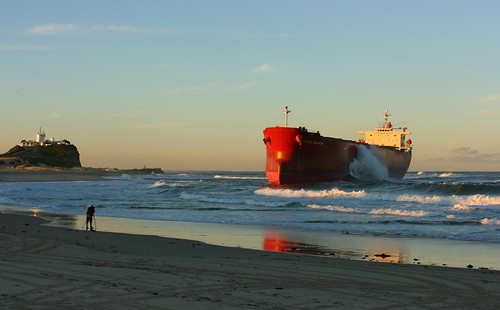
Bad weather, seamanship blamed for Pasha Bulker grounding: report

Bad weather, seamanship blamed for Pasha Bulker grounding: report

Posted Wed Jan 23, 2008 9:01am AEDT

The Australian Transport Safety Bureau (ATSB) has finished its draft report into the grounding of the Pasha Bulker off Newcastle, in the New South Wales Hunter, but expects to finetune the document before releasing the final paper in March.

NSW Maritime found the ship's grounding on Nobbys Beach was caused by horrendous weather conditions and poor seamanship by the ship's master.

The ATSB's probe is focusing on the conditions surrounding the event and the lengthy queue of ships off the Newcastle coast at the time.

A spokesman says the draft report will be sent to relevant stakeholders, including the Newcastle Port Corporation, allowing them to comment on the preliminary findings.

OTHER MARINE NEWS...

Hong Kong hydrofoils crash in fog

HONG KONG, China (AP) -- Two hydrofoils ferrying passengers between the Chinese territories of Hong Kong and Macau collided Friday night in heavy fog, seriously injuring 19 people, a Macau government spokesman said.

art.ferry.crash.ap.jpg


One of the damaged high-speed ferries docks in Macau.

The poor visibility was also blamed for a number of other maritime accidents in the region. Parts of China's southern coast were enveloped in fog due to a warm, humid maritime air stream.

The 10 men and nine women passengers seriously hurt in the Hong Kong-Macau collision suffered mainly head injuries and bone fractures that were not life-threatening, said Alex Che, a spokesman for the government of Macau. Another 114 passengers suffered lighter injuries, Che said.

"All the glass shattered and the front of the ship fell off," a male passenger, identified only by the surname Chan, told Hong Kong's Cable TV.

Wong Soi Man, director of Macau's Maritime Administration, said the accident's cause had not yet been determined, but "heavy fog must be one of the key factors."

The accident occurred closer to Macau and the injured were being treated there, he said.

In another incident, thick fog blanketed China's commercial center, Shanghai, where an unlicensed river ferry carrying 22 people capsized Friday, leaving 10 missing, China's official Xinhua News Agency reported.

The ferry, one of many that operate in the area without proper safety equipment or certification, sank near the city's Wusong pier shortly after the accident, Xinhua said.

And 66 people were rescued from a ferry that ran aground near the coastal city Zhuhai near Macau, Xinhua said.

Hours earlier, another high-speed ferry traveling west from Hong Kong to Macau and carrying more than 370 passengers hit a small fishing vessel, said Hong Kong Marine Department spokeswoman Daisy Lo.

No one was injured and both vessels continued their journeys.

Ferry operator Turbojet scaled back its services to Macau to once every half hour -- from its usual peak frequency of every five minutes -- and said travel time would take half an hour more than the usual one-hour journey.

The foggy weather slowed traffic on a key route that transports gamblers to booming casino enclave Macau, which surpassed the Las Vegas Strip in gaming revenue in 2006

FROM MARITIME BULLETIN

m/v Sergiy Skadovskiy sunk in Azov sea - 1/19/2008 04:11

January 19, Azov sea – m/v Sergiy Skadovskiy sunk in 45.59.6N 036.47.7E between 06.00-08.00 LT. Crew evacuated at 02.40, total blackout, energy for pumps from tug Portovik. 06.10 – emergency pumps and salvage team evacuated, further salvage attempts believed futile. Icebreaker Kapitan Belousov with vessels convoy left scene for Kerch strait, tug Portovik standing by to monitor sinking. m/v Sergiy Skadovskiy was enroute from Mariupol port to Black sea with 3100 tonns of grain on board. No further details, but looks like vessel was holed while under icebreaker convoy, either by ice or by some other vessel.


Sergiy Skadovskiy – dwt 3346, built 1985 USSR, flag Ukraine, owner UKRAINIAN COMMERCIAL FLEET, IMO 8725058.


AND

ONE MO TIME!

Beset in ice, some of the crew rejected evacuation - 1/20/2008 04:33

January 19, signal from EPIRB-406 – S&R plane from Khabarovsk spotted two non-propelled barges and two crafts beset in ice, with 14 people on board, all from gold mining private company. With mining cargo on board, they’ve been heading for Cape Odyan, 155 nm SW from Okhotsk port. Plane dropped food and other supplies. January 20 – helicopter from Nikolaevsk-on-Amur took on board 6 persons, others decided to stay with barges and crafts, maybe till spring time, waiting for clear water.


January 19, 08.50 LT – EPIRB-406 signal from 56.21N 140.13E (about 200 nm north off Nikolaevsk-on-Amur port). Area covered by ice 1 meter thick. Several vessels in the area directed to the scene, no communications, no radio alert. EPIRB-406 – owner unknown, last data 5-7 years old, former owner Sakhalin Dalso Co Ltd now unexisted. Regualr passenger flight Nikolaevsk-Okhotsk searched area, but spotted nothing. Signal loud and clear, air search under way.

LASTLY FROM HOLLAND AND KNIGHT

DHS – National Response Framework

The Department of Homeland Security (DHS) issued a news release stating that the National Response Framework (NRF), which replaces the National Response Plan, will come into effect 60 days after the official notice is published in the Federal Register. The NRF informs emergency management practitioners by explaining the operating structures and tools routinely used by first responders and emergency managers at all levels of government. It is designed to be scalable, flexible, and adaptable; always be in effect; and articulate clear roles and responsibilities among local, state, and federal officials. (1/22/08).


RS

Tuesday, January 22, 2008

Are we really prepared?

I am continually amazed by reports like the following. We are entering 2008 and still there are many County and State Emergency Management Agencies that still lacking the proper funding.

I have just one question. What's it going to take?

Preparedness center lags on hiring, training Jan 12, 2008 @ 05:27 PM By JENNIFER FUSCO Observer-Dispatch WHITESTOWN — New York state is spending $3.4 million this year on a state Preparedness Training Center that’s fallen far short of meeting initial projections for both employees hired and emergency responders trained.

Total spent: Close to $3,000 per police officer, firefighter, correction officer, health official or National Guardsman trained in 2007.

SLOW TO PREPARE
WHAT
* The State Disaster Preparedness Center was announced in December 2005 for the then-Oneida County Airport in Whitestown.

* Its purpose is to train emergency personnel for situations dangerous to the public including terrorist attacks.

THE GOAL
* State officials said it could become a hub for anti-terrorism training in the Northeast.

* Officials projected more than 25,000 trainees per year and the hiring of dozens of employees.

THE REALITY

* Fewer than 1,800 people have been trained, 641 in 2006 and 1,100 last year, the state says.

* The center employs 10 people.

* It lacks sufficient classroom space at the airport site and conducts some classes at Utica College.

PARTICIPANTS
* A total of 376 agencies used the center in 2007, according to the state Office of Homeland Security.

* Groups included the Fire Department of New York, the Syracuse fire Department, the Broome County Department of Health and the National Guard.

NEW HOPES

* The state said it will double the number of classes from 40 to 80 in 2008, serving an additional 275 emergency responders.


Local and state officials say they remain committed to the center, which opened two years ago in the terminal building of the former Oneida County Airport.

Still, some are concerned with its slow growth rate.

“This program needs to start moving in the direction of strong activity,” said Legislator William Goodman, D-Whitesboro. “It’s not moving fast enough.”

The O-D reviewed records and interviewed state and local officials about the center, which was once touted as New York’s hub for emergency-response disaster training for first responders.

The O-D’s findings include:
* The 10 people employed at the center represent only one-sixth of hiring goals.
Now, instead of as many as 60 jobs added in Whitestown, officials are projecting only 20.

* The 1,100 public-safety and health personnel trained in 2007 represent less than 5 percent of the initial projection of 600 trainees per week.

* More than two years after the center was created, it still lacks sufficient space at the former airport and must conduct some classes at Utica College. Officials blame the delayed signing of a lease.

* The O-D repeatedly requested a list of the employees at the center, as well as their titles and salaries, but the state failed to provide it. The O-D has filed a Freedom of Information Law request.

State officials offered no clear timetable for meeting initial projections for hiring and training.

Dennis Michalski, a Homeland Security spokesman, said classes at the center will double from 40 to 80 this year, but would not predict how many people would be trained in 2008.

“That's the unknown,” he said. “We can't speculate on numbers.”

Later, another Homeland Security spokeswoman, Jody Ankabrandt, said the number of trainees would rise at least 20 percent this year, or by about 275 people.

Initially, the center was supposed to train more than 25,000 emergency responders per year.

Classes will be on subjects such as cybersecurity, bombs and weapons of mass destruction.

State Assemblywoman RoAnn Destito, D-Rome, said she follows the progress of the center closely, and is confident it will grow as projected.

“As far as I’m concerned, the future is very bright for the Homeland Security center,” she said. “If I have any disappointment, it’s the time frame in which it’s been moving.”

Oneida County Executive Anthony Picente said it’s too early to tell if taxpayer money is being well spent at the Whitestown center.

“I don’t feel I can answer that right now,” Picente said. “If a year from now the same numbers exist, then it’s not.”

‘A model for the nation’

When then-Gov. George Pataki announced Whitestown would get the center in December 2005, officials hoped it would be the type of economic boost the area needed.

“Our goal is to develop this training facility into a federally recognized and accredited center, which will serve as a model for the nation and the training hub for the first response community from across the Northeast,” Pataki said at a Dec. 5, 2005, news conference. “The selection of the Oneida County Airportwill ensure that this important training begins as soon as possible.”

Leaders said the center would create jobs, boost local businesses and raise Oneida County's profile. The Convention and Visitors Bureau spoke of hotel rooms filled with hundreds of trainees each week.

Some trainees did come – from the New York Police Department, from Niagara County Emergency Management, from the Oneida Indian Nation. But they did not come in nearly the numbers initially expected.

On Friday, a sign declared the old airport terminal to be the home of the State Preparedness Training Center, but the building sat amid a vast expanse of empty parking lot, with only a few vehicles parked next to the structure. The center did conduct training, but at Utica College, which had available classroom space that the former airport site lacks.

Spitzer spokeswoman Jennifer Givner said the state is committed to the center and its growth.

“Clearly, I would say emergency preparedness is the utmost priority for the governor in this administration,” she said. “We’re definitely meeting the same numbers last year, with hopes to exceed that.”

Budget details sought
The center’s projected 2007-08 budget is $3.4 million, according to the state’s Budget Office. The O-D has filed a Freedom of Information Law request to learn just how the money is being spent.

The center employed nine people a year ago, and 10 now. Their names and salaries are also the subject of an O-D FOIL request.

The former airport ultimately should see about 20 employees working at the center, Destito said.

Homeland Security spokeswoman Amy Bonanno said there are 64 positions on the books for the center.

Some of those jobs will be in Albany, not Whitestown, but Bonanno said she was unsure of the breakdown.

Whatever the number, Picente said the center was never about the number of jobs. It was about making the region a hub for Homeland Security training and about an economic impact from high volumes of trainees traveling here.

“It’s going to take a couple of years to grow that much,” Picente said. “There’s no question it’s moving much slower than we thought, and I hope in this new year it will begin to move.”

Hope for progress
Why hasn’t more occurred?

Leaders cited the change in gubernatorial administration a year ago, as well as lease issues.

The lease between the county and the state was signed several months ago, which gives the center more space for additional programs and more training.

“I would hope we would see those numbers by June or so,” Picente said, referring to an increase in training numbers.

State Sen. Joseph Griffo, R-Rome, acknowledged the center hasn’t met its projections, but said part of that is due to the change in administration from Pataki to Spitzer — which happened shortly after the center first opened.

“Each administration has to pursue the direction they want to pursue,” he said.
Protecting the public remains a priority in the post-9/11 era, Griffo said. Having the center in Oneida County meets that need and also creates the potential for a greater economic impact locally, he said.

“I’ve got to give the benefit of the doubt to the administration,” Griffo said.
EDGE not involved

Mohawk Valley EDGE is the region’s main economic-development arm. It did not have a role in bringing the training center to the Mohawk Valley, spokesman Rob Duchow said.

He would not comment on the initial goals for the center.
“This is an investment that New York state wanted to make,” he said. “And for
them to invest in our community is good for us, opposed to investing in another
part of the state.”

The center is worth having as long as the state manages it right, Goodman said.
As for Legislator Goodman, he retains some optimism.

“The state itself will hopefully move more rapidly to make sure the goals are achieved that were presented in the past,” he said. “I think the concept is very good.”

Still, he said, he’d be watching.

“It should be an ongoing monitoring system,” he said.


MARITIME NOTES


Ministry of Transport requires report on Vanessa sinking
17 January 2008 | 13:31 | FOCUS News Agency
Sofia. Bulgaria’s Ministry of Transport sent a letter to the Ministry of Foreign Affairs requiring the Ukrainian part to introduce the report, worked out by the Commission engaged with the investigation on the Bulgarian Vanessa ship’s si1qazzzzzzz1qa1qa

On Wednesday, the Commission, established by Ukraine’s PM Yulia Timoshenko, has a sitting in Kiev. Bulgarian experts from the committee on ship accidents and failures to the Ministry of Transport and representatives of the Bulgarian embassy to Ukraine took part in the sitting.

RS


Friday, January 18, 2008

Its a day for ALERTS! Twisters and Ships!

While I have been blogging about the twisters we had in Illinois and Wisconsin. We are not the only ones who got hit.

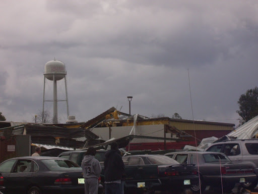
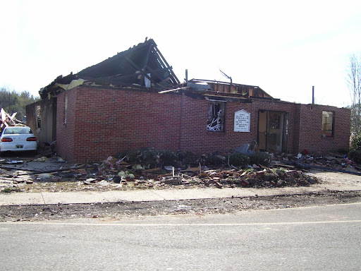
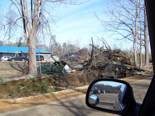
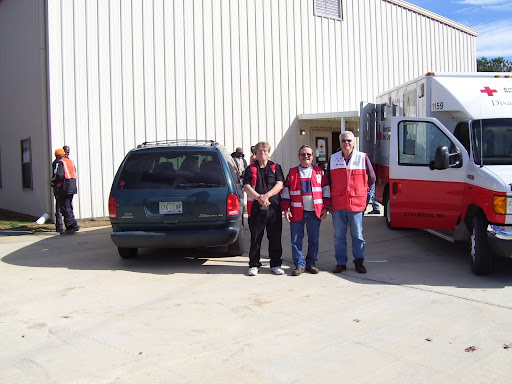
I received a plea for help from a friend of mine who works for a local chapter of the Red Cross in Columbus, Mississippi. The Chapter has been responding to the damage done by a tornado around January 8 2008


I ask everyone who visits my blog to consider sending a donation to the "Local Chapter" to help them out. Mississippi is one of the poorest States in the United States so every penny counts....

If anyone wants a copy of some of the damage pictures from this twister please drop me a line.

Hi every one ;

My Chapter is in need of donations. We had a Tornado come through two of our counties we service. So far the operation has cost about $70,000.00 this does not qualify for a national response and we must provide all funds for this operation. We service 5 counties in
all at our chapter i am asking if you can send a small check to our Chapter to help with the cost. the Chapters name and address is:

Att: Pauline Redmond
Tenn-Tom Chapter of the American Red Cross
220 5Th Street North
Columbus, MS 39703
(662)328-5710

I am sending you some pictures we fed 21,000 meals and 36,00 snacks for residences and workers in the area.there are approximately 200 homes affected by this storm and two counties in our district. Thank you for listening our small chapter is in need because we
still have fire families and military cases that will rely on our funds through out the year.

Thank you

Pauline Redmond

Disaster Logistic Coordinator

Here is the NWS Jackson report on the tornado events.


January 10th Severe Weather

The second week of January 2008 was quite active with respect to severe weather. Two events impacted the region in a span of 3 days which produced several tornadoes, large hail and wind damage across the area.

On January 10th a vigorous storm system developed over the southern portions of the Midwest and moved northeast towards the Ohio valley. A strong cold front swept across the area during the late morning into the afternoon hours and strong to severe thunderstorms developed out ahead of it. All of the ingredients for tornadic development came into place as warm Gulf moisture pushed northward into the area out ahead of the front. The thunderstorms developed in eastern Louisiana and quickly moved across central Mississippi during the late morning and afternoon hours. As the storms progressed eastward, good instability combined with very strong wind shear for supercell development east of the Mississippi River, with the storms reaching maximum intensity along and east of the interstate 55 corridor.

Teams of National Weather Service meteorologists, with assistance from state and local emergency management officials, have been working to record and analyze storm damage across the area. After surveying the tracks of several severe storms across the area, the NWS has determined that eight tornadoes were produced across the central third of Mississippi by those storms.

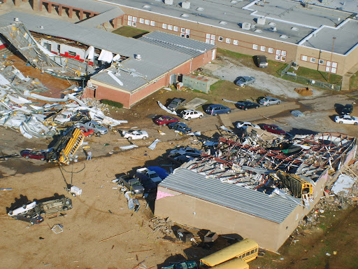
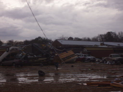
By far, the most damage was produced by a single "supercell" thunderstorm that moved from north of Vicksburg through north central and northeast Mississippi during the late morning and early afternoon hours. This single storm produced three strong tornadoes, all of which were rated as EF3 on the Enhanced Fujita tornado damage scale. The most significant damage occurred in Caledonia in Lowndes County, where a school gymnasium was destroyed along with a number of school buses and vehicles in the area. Even though the school complex had 1900 people in it at the time of the tornado, only three minor injuries were reported at that location. A tornado warning was issued for this area by the NWS in Jackson about 39 minutes before the tornado developed to the southwest of Caledonia, and approximately 41 minutes before the damage occurred at the school in Caledonia.

The longest track tornado from this event occurred in eastern Attala and Choctaw Counties. A tornado tracked for 24 miles from just west of the Ethel community in Attala County to about two miles south of Ackerman in Choctaw County. This was the tornado responsible for heavy damage to a dairy complex south of the Weir community. This is the longest track for a tornado in the central Mississippi region since the tornado outbreak of November 24, 2001.

The low-level circulation associated with this first supercell intensified as it approached Goodman in Holmes County, and it was apparent that a strong tornado had formed (KDGX radar image at 11:56AM). This intense circulation remained apparent in western Attala County near Sallis (KDGX radar image at 12:05PM), and in northeast Attala County from near McCool along the Natchez Trace Parkway into Choctaw County (KDGX radar image at 12:48PM).

The low-level circulation reintensified upon entering northern Lowndes County in the Columbus AFB vicinity (KGWX radar image at 2:07PM) where severe wind gusts greater than 60 mph were observed. A strong tornado touched down near Caledonia (KGWX radar image at 2:16PM) before moving east into Alabama.

A second supercell that organized near the Mississippi River in southwest Mississippi before midday tracked from Claiborne County, through the northern Jackson Metropolitan Area, and finally into Noxubee county in northeast Mississippi by mid afternoon. This storm was responsible for 5 different tornado touchdowns along its path, as well as many reports of high winds and hail. National Weather Service storm survey teams rated these tornadoes as EF0s and EF1s and a majority of the relatively minor structural damage associated with them occurred just southwest of the Pearl River Resort in Neshoba County.

The National Weather Service would like to thank officials from MEMA and the affected counties` Emergency Management Directors for their assistance in performing these damage surveys.

*NOTE: All radar images are 0.5 degree, Storm Relative Velocity and Reflectivity.

Damage Reports


Preliminary Local Storm Reports

Here are some of the reports on these rare January 2008 tornadoes from NOAAWatch

Severe Weather in the Lower Mississippi Valley and Washington State
Fri, 11 Jan 2008 08:07:51 EST
Approximately 140 reports of severe weather were received throughout parts of Tennessee, Kentucky, Illinois, Louisiana, Georgia, Mississippi, Alabama, and Washington. The majority of these reports were wind damage reports. 21 tornadoes were reported throughout parts of Mississippi, Alabama, Louisiana, and Washington. While no fatalities have been reported, at least 18 injuries have occurred with the storms in Alabama and Mississippi. Numerous homes, farms, businesses, and other structures have also been destroyed or damaged. In Caledonia, Mississippi, a tornado struck an elementary school campus, destroying the gymnasium and heavily damaging other school structures. Three children were injured at the school. Details...

Severe Weather Reported Wednesday
Thu, 10 Jan 2008 07:43:06 EST
There were numerous reports of wind damage across parts of New York on Wednesday. A peak wind gust of 66 mph reported at Massena NY. Many other reports of 55 to 60 mph winds across St Lawrence county. Numerous roofs are reported damaged/blown off. At least one tractor trailer was reported to be tipped over by the high winds. Details...

Severe Weather Reported Tuesday
Wed, 09 Jan 2008 05:47:24 EST
Tornadoes were reported on Tuesday in Arkansas, Missouri, and Tennessee, with one death reported in Arkansas. Penny size to golf ball size hail was reported over parts of Texas, Arkansas, Mississippi, Alabama, and Tennessee. Damaging winds were reported from the Lower Mississippi Valley, across parts of the Ohio Valley, and into western New York. Details...

Deadly tornadoes across the Midwest
Tue, 08 Jan 2008 05:49:16 EST
Tornadoes were reported Arkansas, Missouri, Illinois, and Wisconsin. Two deaths were reported with the tornadoes. Damaging thunderstorm winds and large hail were reported extending from Oklahoma into Michigan and Wisconsin. Baseball size hail was reported in several locations in Missouri. Details...


MARITIME STORY - SWASH
Severe Weather Automated/Assisted Ship Handling (SWASH)
Written by Professor Dick K.P. Yue and Dr. Yuming Liu
Center for Ocean Engineering


 We envisage a scenario in the near future that a fleet of agile unmanned surface vessels (USV), capable of cruising at high speed and following optimized courses through severe environmental conditions, can carry payloads and/or perform missions heretofore impossible or too dangerous for manned ships.

Based on real-time sensing and forecasting of the environment and other factors, and optimum autonomous control, such vessels are able to make rapid maneuvers to negotiate or evade extreme wave conditions and/or hostile pursuers. The surface vessels allow favorable payload to fuel requirements compared to airborne (or submarine) platforms. On the other hand, the possibility of these vessels serving as platforms for drone airplanes or AUVs, and even themselves becoming airborne or submerged at a certain phase of the mission may provide a powerful paradigm shift in naval operations.

The realization of the above scenario requires the development and integration of a number of capabilities all to be performed in real time: (1) sensing of the local wave field; (2) forecasting of the local wave field; (3) prediction of the vessel responses in waves; and (4) control and optimization of the vessel(s) and course. Recent developments in each of these areas, especially in sensing and forecasting of nonlinear wave fields, have substantially increased the possibility for this to be achieved.

The objectives of this study are: (i) to develop a virtual simulation environment to demonstrate the feasibility of applying advanced technologies in these areas to enable substantial improvements in operational capability for single/multiple unmanned/manned surface vehicles traveling under stressing environmental conditions; (ii) to identify the key developments necessary for the realization of this capability in the near future; and (iii) (ii) to develop the technologies in the bottleneck areas, especially in wave prediction, to bring this capability to real-time applications in realistic environments.


UPDATE ON ICE PRINCE - MCA ALERT

MV ICE PRINCE

ICE1

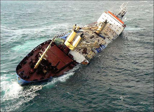
At 19:08hrs on Sunday 13 January 2008 the 6467 GRT cargo vessel MV ICE PRINCE in a position of 27 nautical miles south east of Start Point, Devon, reported that her cargo of timber had shifted resulting in a 25-35 degree list to port.

Attempts were made on Monday 14 January to put salvors on board the vessel, however this was thwarted due to adverse weather conditions

In the early hours of Tuesday 15 January the vessel started to sink in a position 26 miles SSE of Portland Bill. The vessel is now at a depth of 62 metres.

The Trinity House vessel ‘PATRICIA’ is en route and on arrival will be laying emergency buoys around the site. A full survey of the wreck site will be carried out on Thursday 17 January 2008. To ensure that the wreck does not pose a hazard to navigation a guard vessel, the Klyne Tug ‘ANGLIAN EARL’, will remain on scene until the survey has been completed.

A Temporary Exclusion Zone of 1000 metres has been implemented around the wreck site.

It has been confirmed that the vessel was carrying 5,258 tons of packaged untreated sawn timber of differing sizes; 2,516 tons on deck and 2,742 tons in the holds. An estimated 2000 tons broke free when she sank. Some of these packages have broken up into individual pieces.

A contractor has been appointed to recover any timber washed ashore. SOSREP has requested that the owners also arrange for recovery at sea of timber in estuaries and inshore waters.

Anyone finding any cargo should report it to the MCA's Receiver of Wreck (ROW) [see link below for fuller details]. Police forces along the south coast have been authorised by the ROW to act on her behalf. People failing to comply with their directions would be comitting an offence for which they may be convicted and fined up to £2500.

ice 2.

There have been reports of a sheen of oil on the surface of the wreck site, but this is being broken up by wave energy and natural sea movement. The salvors are currently planning how best to recover, with minimal risk to the environment, the oil and pollutants that are currently contained within tanks on the vessel.

MCA are conducting remote sensing aerial surveillance flights to ascertain the extent of the pollution. These aircraft have sensing equipment which can accurately assess the amount of oil on the sea surface both during the day and at night. In addition, the MCA have requested satellite imagery from EMSA (European Marine Safety Agency). Satellites will also be used to monitor the discharges of oil.

Please report any sighted timber to Solent Maritime Rescue Coordination Centre on

02392 559021

02392 559022

Where a vessel is wrecked ... any person (who) conceals or keeps possession of any such cargo or refuses to deliver any such cargo or article to the receiver. It is also an offence of failing to report the wreck to the Receiver.

ICE PRINCE further information/contacts/ Q&A

London Club Warns on Heavy Weather Personal Injuries London Club Warns on Heavy Weather Personal Injuries

THE London P&I Club reports that recent personal injury cases which it has handled have included accidents in which the ship’s motion in heavy weather has been a causative factor.

In the latest issue of its StopLoss Bulletin, the Club notes, “The types of incidents reported have included injuries to crew members falling while working aloft, a hand injury when a heavy auxiliary engine part unexpectedly shifted while being removed for maintenance, and a chest injury suffered when a power tool slipped as a ship rolled.

“Where a risk assessment had been carried out in respect of the accidents involving deck crew, the responsible officer had been fully aware of the prevailing conditions but had not made sufficient allowance for the ship’s motion.

“Interestingly, in the cases where the task was being performed in the engine room, the entry on the risk assessment form for ‘Weather and Sea Hazard’ was in each case “not applicable”.”

The Club concludes, “While it is the case that dealing with rolling, for example, is less of an issue for someone on the bottom plates in the engine room than it is for a crew member on the monkey island, these recent cases are reminders that, when a ship rolls, the engine room moves too.”

  • The London P&I Club, managed by A Bilbrough & Co, is one of the leading clubs in the International Group of P&I Clubs. It pursues a policy of selective, quality expansion and strategic investment to maintain financial strength.


Chicago Weather ALERT! Cold does not even express it!
Have warm and great weekend!
RS

Thursday, January 17, 2008

Weather? HA! The Work Goes On!

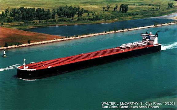
Work is under way today to refloat the Walter J. McCarthy Jr. by pumping water out of the laker’s ballast tanks.

The 1,000-foot-long laker’s engine room flooded Monday after a submerged object punctured the McCarthy’s hull as the ship was backing into a slip at Superior’s Hallett No. 8 Dock about 11:30 a.m. The McCarthy’s crew closed the engine room’s watertight doors and evacuated the room as the ship’s stern settled to the bottom in 20 feet of water.

“Calculations support that the vessel will float regardless of the flooded engine room if de-ballasting occurs,” the U.S. Coast Guard said in a news release. “To do so, the vessel will utilize shore power to operate internal and external pumps. Engineers involved in the salvage believe it will take two to three days to complete the de-ballasting.”

Work to empty the ship’s ballast tanks began Tuesday evening. The tanks hold lake water to help stabilize the ship when it is empty or lightly loaded.

Once the ship is refloated, divers will be able to determine the extent of the damage to the McCarthy’s hall. After the ship’s hull is patched, the water in the engine room will be pumped to trucks for proper treatment and disposal.

The water fills the engine room to a depth of 20 feet, covering the ship’s four 3,500-horsepower General Motors Electro Motive Division diesel engines. Response personnel estimate that approximately 450 gallons of miscellaneous oils have been removed from the flooded engine room, the Coast Guard said. There are an additional 2,500 to 3,000 gallons of oil and fuel in adjacent tanks, engines and generators, but there is no threat of those liquids escaping, the Coast Guard said.

Once the engine room is pumped dry, officials will be able to determine if the ship can be repaired where it is or whether it will have to enter dry dock.

Workers may rebuild the ship’s engines where it sits now, said Rhonda S. Johnson, spokeswoman for GATX, the parent company of the McCarthy’s owner, the American Steamship Co.

The McCarthy is 1,000 feet long, 105 feet wide and has a dead weight capacity of 62,100 gross tons at a draft of 27.5 feet. The ship transports western coal from Superior to Detroit Edison’s St. Clair and Monroe, Mich., power plants. Built as the Belle River by the Bay Shipbuilding Corp. at Sturgeon Bay, Wis., the ship entered service in 1977. It was renamed the McCarthy in 1990 to honor the former chairman of the Detroit Edison Company.


UPDATE ON THE ICE PRINCE

Here are two recent videos regarding the Ice Prince a cargo ship loaded with more than 300 tonnes of oil which sank in the Channel 26 miles south-east of Portland Bill, spilling its load of timber.

Environmentalists are concerned that coastline and marine life could be harmed if storms breach the hull of the Ice Prince. There were also worries that if its cargo of wood washes up in southern England there could be a repeat of the chaotic scenes a year ago when scavengers descended on the Devon coast after the MSC Napoli shed about 50 containers.


UK. Receiver of Wreck warns against stealing MV Ice Prince cargo

Wednesday, 16 January 2008

At a meeting this morning convened by the Secretary's of State Representative for Maritime Salvage and Intervention (SOSREP) Hugh Shaw, various options were discussed on minimising the impact of the loss of cargo or oil from the sunken `Ice Prince.

Representatives from the Environment Group, Police, local authorities and the owners and salvors also attended the meeting.

A guard vessel, the Klyne tug, "Anglian Earl" will remain on scene until Trinity House have completed their survey of the wreck site. This is to ensure that the wreck does not pose any hazard to navigation.

The salvors are currently working on a plan to decide how best to recover the oil and pollutants that are currently contained within tanks on the vessel to minimise the risk of environmental impact.

There have been reports of a light sheen of oil on the surface at the wreck site, but this is being broken up by wave energy and natural sea movement.

The timber cargo that broke free from the vessel when she sank is estimated to be 2,000 tons of untreated sawn timber of differing sizes. Already some of the packages have broken up into individual pieces.

Discussions are taking place with the owners to appoint a contractor to be responsible for the collection of the cargo.

The MCA anticipate the cargo of timber will reach land between the Dorset/Hampshire border and East Sussex.

Police forces along the south coast are working closely with the Maritime and Coastguard Agency and the Receiver of Wreck.

Police Forces have been authorised by the Receiver of Wreck to act on her behalf. People failing to comply with their directions would be committing an offence for which they may, on conviction, be fined up to £2,500 - and may be arrested.

Under Sections 236 and 237 of the Merchant Shipping Act 1995: an offence would be committed: where a vessel is wrecked ... any person (who) conceals or keeps possession of any such cargo or refuses to deliver any such cargo or article to the receiver...'

It is also an offence of failing to report the wreck to the receiver.

Under current control measures that are in place any birds or wildlife found dead should be reported immediately to the RSPCA on their emergency number 03001234 999 who will respond appropriately.

WEATHER STORY

NWS Chicago (Lot)
has posted its Skywarn Spotter training schedule...

Severe Weather Spotter Talk Schedule

Below is a listing of upcoming severe weather spotter talks...
Click here to see the Spotter Training FAQ page

February, 2008 - Upcoming
Day City, State Time Location
11 Naperville, IL
(DuPage County)
7:00pm CST City Hall, Council Chambers, 400 S. Eagle.

Contact Information: 630-742-3782
13 Evergreen Park, IL
(Cook County)
7:00pm CST Fire Dept., 9000 S. Kedzie Ave.

Contact Information: 312-603-8180
20 Kankakee, IL
(Kankakee County)
7:00pm CST Kankakee Community College, Auditorium

Contact Information: 815-802-7174
25 Minooka, IL
(Grundy County)
6:30pm CST Fire Station 1, 413 W. Mondamin St.

Contact Information: 815-941-3200
26 Sandwich, IL
(DeKalb County)
7:00pm CST TBA


27 Plainfield, IL
(Will County)
7:00pm CST Police Dept., 14300 S. Coil Plus Dr.

Contact Information: 815-740-8351

March, 2008 - Upcoming
Day City, State Time Location
03 Evanston, IL
(Cook County)
2:00pm CST Civic Center, 2100 Ridge Ave

Contact Information: 312-603-8180
03 Evanston, IL
(Cook County)
6:00pm CST Civic Center, 2100 Ridge Ave

Contact Information: 312-603-8180
06 Dixon, IL
(Lee County)
7:00pm CST Public Safety Building, 220 S. Hennepin Ave.

Contact Information: 815-284-3365
10 Ottawa, IL
(La Salle County)
7:00pm CST Ottawa High School, Room 420, 211 E. Main St.

Contact Information: 815-433-5622
11 Oglesby, IL
(La Salle County)
7:00pm CST Illinois Valley Community College, Room 316

Contact Information: 815-433-5622
12 Melrose Park, IL
(Cook County)
7:00pm CST Senior Center, 900 N. 25th Ave.

Contact Information: 312-603-8180
13 Warrenville, IL
(DuPage County)
7:00pm CST City Hall, 28W701 Stafford Place

Contact Information: 630-682-7925
15 Wheaton, IL
(DuPage County)
8:00am CST Wheaton College, Coray Gym ***There is a fee. Must Register in Advance***

Contact Information: 630-682-7925
17 Aurora, IL
(Kane County)
10:00am CST City Council Chambers, 44 East Downer Pl.

Contact Information: 630-801-6512
17 Aurora, IL
(Kane County)
7:00pm CST City Council Chambers, 44 E. Downer Pl

Contact Information: 630-801-6512
18 Lockport, IL
(Will County)
7:00pm CST Lockport Central High School, Auditorium, 1222 S. Jefferson St.

Contact Information: 815-740-8351
19 Joliet, IL
(Will County)
10:00am CST County Building, 2nd Floor Board Room, 302 N. Chicago St.

Contact Information: 815-740-8351
19 Wilmington, IL
(Will County)
7:00pm CST City Hall, 1165 S. Water St.

Contact Information: 815-740-8351
20 Pontiac, IL
(Livingston County)
7:00pm CST Public Safety Building, 413 N. Mill St.

Contact Information: 815-844-7171
22 Rockford, IL
(Winnebago County)
8:30am CST Chicago-Rockford Int'l Airport, Public Safety Building

Contact Information: 815-987-5990
24 Clarendon Hills, IL
(DuPage County)
7:30pm CST Church of Holy Nativity, 55th and Richmond.

Contact Information: DuPage Radio Club www.w9dup.org
26 Lyons, IL
(Cook County)
7:00pm CST Lyons EOC, 7801 Ogden Ave.

Contact Information: 312-603-8180
27 Crystal Lake, IL
(McHenry County)
7:00pm CST McHenry Community College, Auditorium

Contact Information: 815-338-6400
31 Tinley Park, IL
(Cook County)
7:00pm CST Admin Building, Kallsen Conference Room, 16250 S. Oak Park Ave.

Contact Information: 312-603-8180

April, 2008 - Upcoming
Day City, State Time Location
02 Matteson, IL
(Cook County)
10:00am CST Matteson Village Hall, 4900 Village Commons

Contact Information: 312-603-8180
03 Crown Point, IN
(Lake County)
7:00pm CST Civic Center, 101 East St.

Contact Information: 219-755-3549
09 Arlington Heights, IL
(Cook County)
9:30am CST Public Works Dept., L.A. Hansen Building, 222 N. Ridge Rd.

Contact Information: 312-603-8180
09 Arlington Heights, IL
(Cook County)
1:30pm CST Public Works Dept., L.A. Hansen Building, 222 N. Ridge Rd.

Contact Information: 312-603-8180

RS

Wednesday, January 16, 2008

January 2008 A Interesting Start to the Maritime New Year!

January 2008 has started out as a lion for the maritime acccident business.

To date (January 16, 2008) there have been some 68 reported casualities world wide. of the 68 incidents, 19 were due to heavy weather with approximately 13 total deaths reported.

There was one reported casuality reported due to terrorism.

Make Light Of Heavy Weather - 16 January 2008

The London P&I Club has warned of the risk accidents caused by heavy weather.

In the latest issue of its StopLoss Bulletin, the club notes, “The types of incidents reported have included injuries to crew members falling while working aloft, a hand injury when a heavy auxiliary engine part unexpectedly shifted while being removed for maintenance, and a chest injury suffered when a power tool slipped as a ship rolled.”

It adds: “Where a risk assessment had been carried out in respect of the accidents involving deck crew, the responsible officer had been fully aware of the prevailing conditions but had not made sufficient allowance for the ship’s motion. Interestingly, in the cases where the task was being performed in the engine room, the entry on the risk assessment form for ‘Weather and Sea Hazard’ was in each case “not applicable”.”

The Club concludes, “While it is the case that dealing with rolling, for example, is less of an issue for someone on the bottom plates in the engine room than it is for a crew member on the monkey island, these recent cases are reminders that, when a ship rolls, the engine room moves too.”

Here are just a few new incidents.


U. S. Coast Guard Marine Safety Unit responds to sinking laker McCarthy at Hallet

Coast Guard Marine Safety Unit Duluth responded to the partial sinking of the 1,000-foot laker McCarthy at the Hallett No. 8 Dock at approximately 11:30 a.m. yesterday The vessel has been made fast to the pier until a salvage plan is in place.

There are no reports of oil in the water. The Coast Guard is working closely with the vessel's owner, the city of Duluth and both the states of Minnesota and Wisconsin to protect the environment. The McCarthy, owned by American Steamship of Buffalo, N.Y., was docking into a slip when it struck an object and began taking on water in the engine room.

The after section of the ship sank to approximately 20 feet at the dock, while the rest of the ship remained above water. The cause of the incident is under investigation.


Three crew airlifted to hospital as freak wave hits vessel

By CHARLOTTE THOMSON

THREE offshore workers were airlifted to hospital yesterday after a freak wave hit their ship in a storm. They were securing cargo on the storage offloading vessel Bleo Holm when the incident occurred, 50 miles north-east of Aberdeen.

The three were taken to Aberdeen Royal Infirmary by air ambulance but the extent of their injuries was not clear last night.

The vessel, owned by Talisman Energy (UK), had a crew of 70 on board.

A spokeswoman for the firm said: "We can confirm that four personnel have sustained injuries following an incident on board the Bleo Holm.

"All 70 people on board have been accounted for.

"The injuries were sustained after items broke free on the deck of the vessel during bad weather, with wind speeds in excess of 40 knots and a swell of nine metres.

"One person sustained minor injuries and has remained on board. Three personnel were airlifted onshore by helicopter for medical treatment."

Last year the firm admitted its safety procedures needed to be improved following the death of an employee on the same vessel on 6 January.

Matthew Grey, 59, of Darlington, suffered fatal injuries while fitting pipes in one of the cargo tanks.

Nick Walker, Talisman UK's vice-president, later admitted that some of its safety systems were not sufficiently robust.


From the BBC
Timber hazard after ship wrecked

Measures are being put in place to protect shipping in the area where a cargo ship sank off the Dorset coast.

The Greek-registered Ice Prince went down about 26 miles (42km) off Portland Bill after being damaged in a storm.

She shed more than 2,000 tonnes of her 5,260-tonne timber cargo - causing a potential hazard to other vessels.

A 1,000m (3,280ft) temporary exclusion zone is in place around the ship, and emergency buoys are to be placed around the area as a visible warning.

Broken bundles

The 6,395-ton Ice Prince sent out its initial emergency call at about 1900 GMT on Sunday.

Rescuers battled gale force winds and rough seas with 16ft (5m) swells to evacuate the vessel's crew. Twelve were airlifted to Portland, Dorset, and eight others taken by lifeboat to Brixham, Devon.

It is understood the members of the Ice Prince's crew were all foreign nationals and were wearing lifejackets and immersion suits when rescued.

The 328ft (100m) ship finally sank at about 0045 GMT on Tuesday in 9ft (2.7m) waves and strong winds.

The vessel was carrying 5,258 tonnes of sawn Swedish red and white timber. About 2,000 tonnes of the cargo was being carried on the deck and a quantity of wood - about 3,000 tonnes - is still believed to be in the hold.

It was also carrying an estimated 400 tonnes of fuel oil and other lubricating oils in its engine spaces.

Coastguards said the risk of oil pollution was low, but they were concerned a "wood slick" of the cargo could be a hazard to shipping.

The 10m (33ft) lengths of wood were put on board in bundles, but sea conditions broke many apart.

Kelly Reynolds, of the Maritime and Coastguard Agency, said: "We believe it is a danger to navigation because there are bundles of wood that are breaking down into loose planks."

Coastguards said they were expecting a "slick" to end up somewhere on the south coast over the next few days. Police forces have been alerted.

Warnings have been sent to all shipping in the area to avoid floating timber and emergency navigational buoys are due to be added in the area on Wednesday.

On Thursday, underwater surveillance equipment will survey the wreck to see how much of a threat it poses.

UPDATE

  • Published Date: 15 January 2008
  • Source: Edinburgh Evening News
  • Location: Scotland

Stricken cargo ship sinks after dramatic rescue for 20 crew

THE cargo ship Ice Prince, abandoned by its crew after she listed to 40 degrees off the Devon coast, has sunk.

Twenty crew were rescued by helicopter and lifeboat in storm conditions last night from the stricken Greek-registered ship after the vessel's cargo of timber shifted and she listed.

A spokesman for the Maritime and Coastguard Agency said: "At 12.45am, the general cargo vessel Ice Prince sank in very rough weather."

He also confirmed a counter-pollution surveillance aircraft would be flying over the scene at first light to see the extent of the debris on the surface of the water.

The Ice Prince, which is more than 328ft long and weighs 6395 tons, sent out an emergency call at 7pm on Sunday after getting into difficulties.

A Portland Coastguard helicopter airlifted 12 of the crew, including a 41-year-old Greek man with a broken leg.

The remaining eight crew members were taken to safety by lifeboat crews from Torbay and Salcombe.

They battled gale force winds and rough seas with 16ft swells to evacuate the men in a mission one lifeboatman described as a "once-in-a-career" rescue.


Rebels bomb oil tanker in Nigeria, exports spared

REUTERS
7:32 a.m. January 11, 2008
PORT HARCOURT, Nigeria – Militants fighting for autonomy in Nigeria's oil-producing south detonated a remote controlled bomb on an oil tanker on Friday, causing a big fire.

It was the second rebel attack on Africa's largest oil industry in a week, but exports of crude oil were unaffected, industry sources said.

'There was an explosion and the tanker went up in flames,' Police Commissioner Felix Ogbaudu told Reuters, adding that the cause was under investigation.

The Golden Lucy was preparing to discharge refined fuel at the main port in the southern city of Port Harcourt when it burst into flames after two loud explosions, witnesses said.

The Movement for the Emancipation of the Niger Delta (MEND), an umbrella organisation for several militant groups, claimed responsibility.

'Freelance freedom fighters working inside the oil industry detonated a remote explosive device that caused the fire,' the group said in an e-mail to the media.

Nobody was killed by the blast but several people received minor injuries, port sources said.

The city port has storage tanks for refined fuels, but is not involved in the export of crude oil. Nigeria's largest oil and gas export terminal at Bonny Island is 30 miles (50 km) away.

VIOLENCE INCREASES

Rebel violence around Port Harcourt has been rising in recent weeks after the collapse of peace talks with the government, and in the wake of an army raid on the hideout of a Port Harcourt militia boss last month.

Militant and security sources told Reuters this week that armed groups were building up weapons and supplies for a major attack on an oil facility.

Two people were injured on Wednesday when MEND-affiliated gunmen opened fire on six oil industry ships in the channel leading to the Bonny Island terminal.

The militants, who want to halt oil exports from Africa's top producer, demand regional autonomy over the vast natural resources in the Niger Delta, development of their impoverished region and compensation for decades of pollution.

Oil output has been running at 20 percent below capacity for two years since MEND launched a wave of bombings of oil pipelines, production plants and export terminals, and kidnapped foreign staff. Thousands of foreign workers have fled and many investments have been put on hold.

Vice President Goodluck Jonathan held a meeting on Thursday with elders and militants from the delta in an attempt to revive the collapsed talks.

He said he would assume leadership of a committee designed to lay the foundations for talks, and set an end-February deadline to conclude his work.

The delta representatives asked the government to stop army raids on militant hideouts and said the prolonged detention of a factional MEND leader in Angola on gun-running charges was an obstacle to progress.

(Writing by Tom Ashby; Editing by Keith Weir)


Heck of a start for a New Year!

RS

Tuesday, January 15, 2008

Tornado Safety and the "Be Ready Campaign"!

Well who would have thought I would be blogging about tornado safety in January?

But as I blogged on January 11, 2008 we in Illinois and Wisconsin in fact had some very rare weather events resulting in at least three tornadoes. So did many other parts of the United States.

Its important to remember that mother nature can surprise everyone at anytime, so we all must be prepared for unusual weather and severe weather anytime.

One of the issues that developed after these rare tornado events occurred were people calling their local 911 system when they heard the tornado sirens of which both Chicago and Milwaukee utilize blasting away.

I cannot stress enough that calling the 911 system to find out what the sirens are for is not a smart idea. First your wasting time. Once you hear these sirens your instructed to "take cover immediately", not call 911 for information and potentially tie up a system designed for dispatching emergencies. We all have to remember that while we are calling 911 seeking information they just might be kind of busy with the results of the reason why the sirens are going off in the first place and we just might take away a 911 operator from dispatching emergency services to someone in need.

For example, here are two recordings of the recent 911 calls into the Kenosha, Wisconsin 911 system during the recent tornado events. Listen to the calls and realize what was really happening while people were calling in seeking information.


| | | | | |

OK, so what do we really need to do when this happens? Well first we all must "Be Ready" for severe weather at all times. Secondly, we all have smoke detectors in our homes to alert us from the beginning stages of a fire. Well we should all also have a Weather Radio as well. These radio's are inexpensive most cost around $20.00. Small investment to keep you and your family safe.

Like a smoke detector keeps you warned a weather radio will keep you alert to developing severe weather and warn you to take action when weather becomes dangerous. Third, have a plan ready, including a communications plan for all family members. This communications plan should also include a rallying point, after the all clear signal has been issued, in case communications is cut due to down wires or lost of cell towers for family member caught outside and away from your home. Finally, if you hear sirens don't call the 911 system, be ready, tune into your local radio and TV news outlets and if you must call someone, use the "non-emergency" number for your local police department". NOT THE 911 NUMBER! Unless your calling in to report a emergency!

But remember while your making this call mother nature can be in your backyard bearing down on you! So more importantly we all have to "Be Ready"!

Storm Spotter/Chaser Richard Niemeyer alerted me to the next “BE READY CAMPAGIN”, for Southern Illinois. This is a FREE PROGRAM! So take advantage of it!

PRESS RELEASE

For Immediate Release

January 14, 2008

SI-CERT Announces the 2008, “BE READY CAMPAGIN”, for Southern Illinois. Do not make Preparedness an After Thought!

Would you place your very survival and that of your family in the Hands of a Stranger?

You would probably respond with “NO”, or, “I hope that I never have to rely on a complete stranger to save my life or that of my family.” However, each of us does this daily with our personal safety.

Do you have life insurance, homeowners insurance, and auto insurance? Would you go even one day of your life without them? Of course not; the financial risk is too great to you and your family. One accident and everything is lost.

But there is another assurance that you have not taken out that could cost you and your loved ones lives. Do you Give Up?

It’s DISASTER PREPAREDNESS!

There are no special books to buy, and the resources and training are available FREE of charge. So let’s make today the first day of that new assurance, the day that Citizens must take personal responsibility for disaster preparedness. Prepare, Protect, and assure yourselves for disasters and emergencies. Remember when disasters or emergencies occur time is of the essence, and if professions are backed up and can’t get there, you may make the difference in the live and death of a loved one. So think about it, do you still want to live without an assurance that could be so costly? Think about it, educate yourself on what to do, so that you can better assure yourself and your loved ones when a disaster or emergency occurs!

SI-CERT Announces the 2008, “BE READY CAMPAGIN” for Southern Illinois. The Southern Illinois Community Emergency Response Team prays that the Citizens of Southern Illinois will join us in improving the safety and readiness of all who live and work here in Southern Illinois. Don’t be left out, take the responsibility that will reward you and your family with increased security and Peace of Mind.

As responsible community minded Citizens it is very important that you attend the 4th Annual Meeting of the “Housing and Neighborhood Action Group”- “Carbondale Conversations for Community Action” as this year’s important topic is Emergency Preparedness. This meeting will provide you with some wonderful resources for both you, and your Neighborhoods. The meeting is 9:30 AM Saturday morning January 19th at the First United Methodist Church, 214 East Main Street, Carbondale, Illinois. The Housing and Neighborhood Action Group - Carbondale Conversations for Community Action has the eventual goal of developing a Community Emergency Response Team (CERT) for Carbondale.

The Southern Illinois Community Emergency Response Team has become a part of a national network of CERT communities. SI-CERT has developed a program that is designed to help communities prepare for and respond after catastrophic disasters such as earthquakes, tornadoes, and other major emergencies. We need you, the Citizen Volunteers, those of civic mind and pride in country, to commit to a life of service in preparation for a day that we all hope will never come. The day of a catastrophic disaster right here in your home town and neighborhood.

The mission of SI-CERT is to be a conveyor for the community, a catalyst for social action and the key resource for Citizen Volunteer involvement in disaster preparedness, response, mitigation and recovery. To be the premier provider of volunteer services through innovative program development with volunteers who are not only prepared for a disaster; but, are trained and equipped to respond with compassion and dedication to help those in need and answer the call to service.

SI-CERT will serve all of the Residents, the Citizen Volunteer’s and the Non-Profit Groups, Governmental Agencies, and the Profit Organization’s in the Sixteen (16) Southern Most Counties of Illinois; namely Alexander, Franklin, Gallatin, Hamilton, Hardin, Jackson, Johnson, Massac, Perry, Pope, Pulaski, Randolph, Saline, White, Williamson, and Union.

SI-CERT will promote, recruit and develop Citizen Volunteers for involvement in charitable service to their communities in times of disaster or community need in all the communities we serve.

SI-CERT will meet the educational needs of the Citizen Volunteers through innovative training programs that will provide them with the skills to be effective in their service to their community in time of disaster and/or community need.

SI-CERT will promote preparedness and development of response capabilities in the counties that we serve and this will be done by the coordination and administration of Citizen Volunteers through Community Emergency Response Teams and Non-Profit Organizations that are active in disaster preparedness, response, mitigation and recovery.

To learn more about SI-CERT go to our new web site at: http://www.sicertinc.org/ or call Richard Niemeyer, KC9JMW at (618)-319-9206 or email richardniemeyer@mchsi.com .

To learn more about the upcoming 4th Annual Meeting of the Housing and Neighborhood Action Group - Carbondale Conversations for Community Action contact Carbondale Conversations for Community Action: at 549-5302 x 386 or studycircles@ci.carbondale.il.us

MISSISSIPPI TORNADO UPDATE

Storm Spotter and emergency aid worker Pauline Redmond was kind enough to send me these photo's of the aftermath of the Caledonia, Mississippi Tornado.


REMEMBER
"Be Ready"!

RS