Tuesday, August 12, 2008

Changes In Winds Could Have Been Cause Of Abrupt Glacial Climatic Change

Changes In Winds Could Have Been Cause Of Abrupt Glacial Climatic Change

ScienceDaily (July 21, 2008)Spanish and German researchers have carried out a collaborative study that shows how during the last glacial period, small variations in the surface winds could have induced significant changes in the oceanic currents of the North Atlantic, and could even have played a role in the abrupt climate change that occurred at the time.

Scientists from the Complutense University of Madrid (UCM) and the Potsdam-Institute for Climate Impact Research in Germany have carried out a study which identifies small alterations in the superficial sea winds as the factors with a key role in the abrupt climatic change that occurred over the last glacial period whose origin is not yet fully understood.

This study, carried out by researchers Marisa Montoya and Anders Levermann, concluded that there is a precise point from which a small variation in the speed of sea winds corresponds to a dramatic change in the Atlantic circulation intensity. According to Marisa Montoya, “If the glacial climate had been in the vicinity of that point, small wind changes could have caused sudden and significant climatic changes during that period”

The study was based on climatic simulations called Last Glacial Maximum (LGM) (the period of maximum extension of the perpetual ice sheets that took place over 21.000 years ago). These simulations have demonstrated the existence of a threshold after which a small change in wind speed causes disproportionately large changes in the sea current speed. The results indicate that these changes in wind speed could have had a particularly important role in the abrupt climatic change of the last ice age.

Climate simulation of the Last Glacial Maximum is one of the principal challenges for experts in this area. The comparison of results from these simulations with climatic reconstructions based on data gathered from natural elements, such as sea sediments or the oldest ice samples; permit the evaluation of the climatic models in conditions independent from the ones used for their design. The results confirm the relevance of the small variations and help further substantiate the hypothesis about the physical mechanisms responsible for the climatic changes observed in the reconstructions.

Both, the climatic simulations as well as the reconstructions, indicate that variations in the Atlantic Ocean circulation could have been the key mechanism responsible for the abrupt climatic change that took place over the ice age. This circulation plays a fundamental role in the regulation of climate on a global scale, since it transports large quantities of relatively warm water from low latitudes to northern regions, softening the climate of countries like Norway or Ireland in comparison with other regions in the same latitude, but with much harsher climates, like Alaska or New York. This study therefore suggests that the changes in oceanic circulation could have been caused by changes in the speed of surface winds.

WEATHER NOTE

Weather radio's early warnings can be lifesavers

August 11, 2008 Eleven minutes.

For about $50, a weather radio could have given Griffith residents an 11-minute heads-up that a destructive, potentially deadly tornado was bearing down on their town.

"(That) can be a long time," professor Bart Wolf, chairman of Valparaiso University's geography and meteorology department, said. "That can mean the difference between life and death if it's a bad enough storm."

It could mean the difference between getting caught in an upstairs bedroom or finding shelter in the basement.

At 8:17 p.m. Monday, 11 minutes before the twister began brawling its way through Griffith, a tornado alert went out from the National Weather Service office in Chicago. It was immediately broadcast across Lake County from the local weather transmitter in Hebron.

"At 8:16 p.m., National Weather Service radar indicated strong rotation in a severe thunderstorm near Calumet City, moving east at 59 mph," the alert said. "The tornado will be near Highland, Griffith, and eight miles north of Schererville by 8:25 (p.m.)."

If you hadn't already run for the basement by then, the alert went on to say that you should run directly to the basement, avoiding any windows on the way if possible.

"All-hazard alert" radios have come a long way in the past decades.

More than just alerting to severe weather, the electronic boxes will squawk when there's a flooding alert, a chemical spill or other environmental hazard, or a terrorist threat or attack.

Moreover, the newer radios can be programmed to sound the alarm for specific counties.

The new Specific Area Message Encoding. weather radios can be told to wail only when there's an alert for the county you live in.

The Hebron transmitter covers Lake, Porter, LaPorte, Newton, Jasper, Pulaski and Starke counties, so the ability to narrow the information that the radio gives out is helpful for the Porter County resident who doesn't want to hear about flash-flood alerts in Starke County at 2 a.m.

And while there are 53 tornado sirens in Porter County and several sirens in at least nine Lake County communities that offer free tornado warnings, these outdoor sirens have one major drawback: they're meant for people outdoors.

If you're sitting inside watching a DVD, said Phil Griffith, director of the Porter County Emergency Management Agency, you're probably not going to hear the siren. If you're watching a DVD, you're not going to see the severe weather logo and information crawling along the bottom of your TV screen.

A weather radio can fill that gap between the media warnings and tornado sirens.

"A weather (radio) alert is the way to go indoors," Griffith said.

Weather radios can be purchased at many area retailers, including Radio Shack and Best Buy.

Contact Erik Potter at 648-3120, or epotter@post-trib.com. Comment on this story at www.post-trib.com.

If you buy one

The new Specific Area Message Encoding, or S.A.M.E., weather radios allow you to program county codes so you receive alerts only for the counties you're interested in. The radio transmitter serving Northwest Indiana is WNG 689 in Hebron, operating at 162.450 MHz. The S.A.M.E. codes for this area are:

Lake 018089

Porter 018127

Newton 018111

Jasper 018037

LaPorte 018091

Starke 018149

Pulaski 018131

MARITIME NOTE

Coast Guard Responds to Fishing Vessel Around on Flemming Island

JUNEAU, Alaska - The Coast Guard Marine Safety Unit in Valdez, Alaska has responded to and is investigating the grounding of the fishing vessel Northern Mariner, which ran aground on the north side of Flemming Island Thursday night.

Two overflights by Alyeska and a Coast Guard helicopter from Air Support Facility Cordova revealed that the Northern Mariner is partially submerged at high tide and there is a 6-foot by two-foot sheen coming from the vessel. The sheen is believed to be from residual oil from the engine room.

The grounded vessel has 25,000 gallons of diesel, 50 gallons lube oil and 300 gallons of hydraulic oil. Fuel tanks are believed to be intact.

There is a reported one-foot hole in the hull and the engine room is flooded.

Three hundred feet of containment boom has been placed around the vessel by responders from Alaska Chadux.

Ship Escort/Response Vessel System’s (SERVS) vessels arrived in the area Friday morning and deployed protective staging in the vicinity of the salmon hatchery in Sawmill Bay and the adjacent village of Chenega, Alaska. SERVS also transported bladders for lightering operations and are standing by.

R&R Diving deployed two vessels and personnel to prepare pumps for lightering the fuel oil and plan to start late Friday afternoon as tanks arrive to hold the oils.

The owner is also working to determine the status of and appropriate disposition of over 350,000 pounds of pink salmon that was onboard.

A Coast Guard Marine Inspector and a pollution investigator are on scene to monitor lightering and salvage operations. Coast Guard, Alaska Department of Environmental Conservation and owner’s representatives have established a command post at the Marine Safety Unit in Valdez to coordinate all activities.

The Northern Mariner, a 110-foot fishing vessel homeported in Seattle, began taking on water Thursday night with four people aboard. The crew then intentionally grounded the vessel to keep it from sinking and abandoned the vessel in a life raft. The Good Samaritan vessel Tenacious recovered all four crewmembers safely and transported them to Whittier.

The cause of the vessel taking on water and the subsequent grounding are being investigated.

RS

Monday, August 11, 2008

NOAA Forecasts Even Stronger Atlantic Hurricane Season For 2008 Than Earlier Prediction

NOAA Forecasts Even Stronger Atlantic Hurricane Season For 2008 Than Earlier Prediction

ScienceDaily (Aug. 8, 2008)In the August update to the Atlantic hurricane season outlook, NOAA’s Climate Prediction Center has increased the likelihood of an above-normal hurricane season and has raised the total number of named storms and hurricanes that may form. Forecasters attribute this adjustment to atmospheric and oceanic conditions across the Atlantic Basin that favor storm development - combined with the strong early season activity.

NOAA now projects an 85 percent probability of an above-normal season – up from 65 percent in May. The updated outlook includes a 67 percent chance of 14 to 18 named storms, of which seven to 10 are expected to become hurricanes, including three to six major hurricanes of Category 3 strength or higher on the Saffir-Simpson Scale. These ranges encompass the entire season, which ends November 30, and include the five storms that have formed thus far.

In May, the outlook called for 12 to 16 named storms, including six to nine hurricanes and two to five major hurricanes. An average Atlantic hurricane season has 11 named storms, including six hurricanes and two major hurricanes.

“Leading indicators for an above-normal season during 2008 include the continuing multi-decadal signal – atmospheric and oceanic conditions that have spawned increased hurricane activity since 1995 – and the lingering effects of La NiƱa,” said Gerry Bell, Ph.D., lead seasonal hurricane forecaster at NOAA’s Climate Prediction Center. “Some of these conditions include reduced wind shear, weaker trade winds, an active West African monsoon system, the winds coming off of Africa and warmer-than-average water in the Atlantic Ocean.”

Another indicator favoring an above-normal hurricane season is a very active July, the third most active since 1886. Even so, there is still a 10 percent chance of a near normal season and a five percent chance of a below normal season.

NOAA’s hurricane outlook is a general guide to the expected level of hurricane activity for the entire season. NOAA does not make seasonal landfall predictions since hurricane landfalls are largely determined by the weather patterns in place as a hurricane approaches.

Five named storms have formed already this season. Tropical Storm Arthur affected the Yucatan Peninsula in late May and early June. Bertha was a major hurricane and the longest-lived July storm (July 3-20) on record. Tropical Storm Cristobal skirted the North Carolina coastline. Dolly made landfall as a Category 2 hurricane at South Padre Island, Texas on July 25. And on August 5, Tropical Storm Edouard struck the upper Texas coast.

“It is critical that everyone know the risk for your area, and have a plan to protect yourself, your family and your property, or to evacuate if requested by local emergency managers. Be prepared throughout the remainder of the hurricane season,” Bell said. “Even people who live inland should be prepared for severe weather and flooding from a tropical storm or a hurricane.”

The Atlantic hurricane season includes activity over the Atlantic Ocean, Caribbean Sea and Gulf of Mexico. The peak months of the season are August through October.

NOAA understands and predicts changes in the Earth's environment, from the depths of the ocean to the surface of the sun, and conserves and manages our coastal and marine resources.

WEATHER NOTE

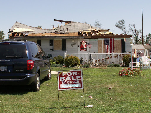
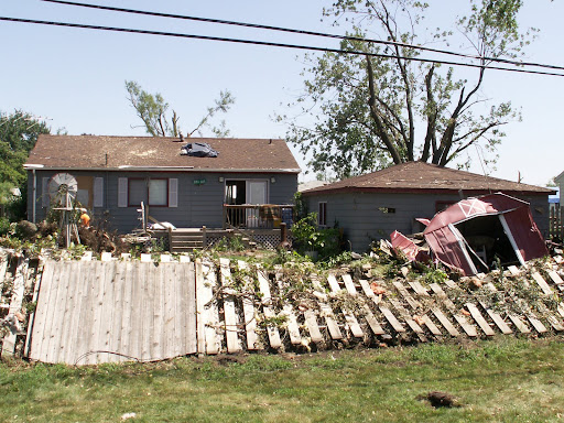
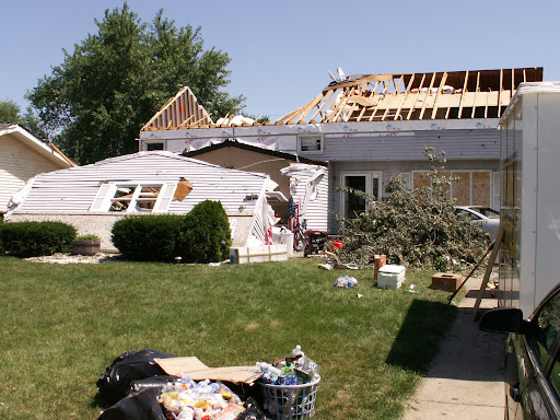
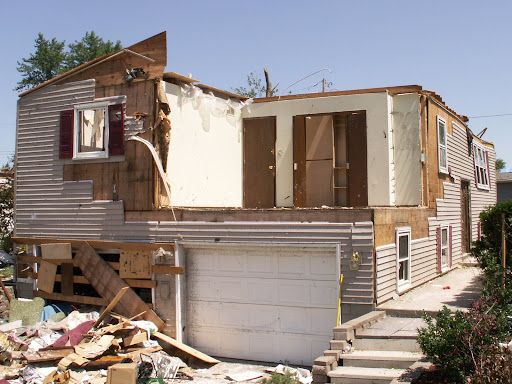
These are storm damage photos from the EF2 Tornado that hit Griffith, Indiana on August 4, 2008. Photo Credit: The Robin Storm /AM 1420 WIMS Severe Storm Intercept Team.


MARITIME NOTE

Salvors refloat grounded chemical carrier off Dutch tourist beach

Independent Dutch towage and salvage company Multraship and Belgian salvage operator URS Salvage & Maritime Contracting have refloated an Italian-flag chemical carrier which grounded off the Dutch coast on July 31.

The 5,045GT ‘Rubino’ grounded off a popular tourist beach at Zoutelande just after high tide. Bathers and swimmers were ordered out of the water to safety. The salvors, operating under an LOF agreement and working in close co-operation with the local authorities, mobilized an expert salvage team and three tugs, with others standing by, to refloat the vessel, which was thereafter towed to the Scheldepoort shipyard for inspection. No severe damage was found, and the vessel has been redelivered to its owners.

Updated: Search For Missing Teen Delayed Until Monday

Weather Conditions Too Dangerous For Divers

Rescue workers delayed the search for a missing 15-year-old until Monday due to bad weather conditions.Officers said the boy was swimming with friends on Saturday and didn’t come up after a strong current battered the group with high waves.Four other children got out of the water OK, rescuers said.A 911 call for help was made at 3:43 p.m. Saturday.A team of 50 people including the Coast Guard, Sheboygan Police and the Sheboygan Law Enforcement Dive team searched the lake.The search was called off at 6:30 p.m. Saturday due to conditions that would be too dangerous for divers.Rescuers continued their search Sunday but had to stop the search again due to the the weather.The search will begin again Monday.

Coast Guard Rescues 4 in Gulf of Mexico


RS

Friday, August 8, 2008

5 Confirmed Tornadoes for the Chicagoland Area!

August 4th High Wind Event (4 Tornadoes Confirmed)

The cluster of thunderstorms which moved across northern Illinois and northwest Indiana on Monday can be described as what is commonly referred to as a mesoscale convective system (MCS).

This is generally a continuous line of thunderstorms spanning many miles, over a long duration, and during which, will affect many locations.

This is a meteorological phenomenon that is not uncommon for northern Illinois and northwest Indiana during this time of the year. The weather pattern is such that, the upper level winds orient themselves in a northwest flow pattern. This orientation of the upper level winds allows waves of energy (upper level disturbances) to traverse across the region. This, coinciding with very warm, moist, and unstable conditions can trigger thunderstorm development which can lead to a complex of thunderstorms similar to what occurred on Monday. As this weather pattern persists, multiple waves of energy can move across the region providing several rounds of MCS’s for the region.

As what was previously noted above, the atmosphere was very unstable. During the day on Monday, persistent southerly winds across the region allowed a stream of very warm and moist air to advect north into the region. This weather pattern, with clearing skies on Monday, allowed temperatures to rebound to near 90 degrees by the afternoon. With dew point temperatures now in the mid to upper 70s across much of the region, very high humidities were produced. This moist, unstable environment provided the energy needed for thunderstorm development to occur. These same muggy conditions provided heat index values between 100 and 105, also validating a heat advisory that was in place until 800 pm Monday evening for areas just outside of the Chicago Metro area.
During the early evening at around 600 PM, an MCS moved into far northwest Illinois. As it continued into the southern portions of Winnebago county and the western portions of Ogle county, a portion of the storm began to bow. The signature at this point in the storm evolution is what provides the name Bow Echo. This type of thunderstorm complex is capable of producing widespread wind damage and possible tornadoes as it moves very fast across a certain location. This bowing structure is induced by mid-level winds (rear inflow jet) penetrating the surface. It is at this time, that the storm begins to bow and wind damage is produced. What can affect its magnitude and longevity is if the low level wind shear is strong. Wind shear is just a change in wind direction or speed with height. The low level wind shear, generally from the surface up to 3 km, on Monday was sufficient to balance out the bowing segment. Thus, allowing the Bow Echo that occurred on Monday to provide a wide swath of very high winds across northern Illinois and northwest Indiana.
What also can occur with a Bow Echo and can lead to significant damage, are low level circulations. These low level circulations are generally near the leading edge of the line, north of the bow apex. It is these low level circulations that can create brief spin ups, or non-supercell tornadoes. Although, these tornadoes are generally brief and weak in nature, they can still create damage as high as EF2. The environmental shear as discussed earlier is what can be the impetus for tornadogenesis along the leading edge of this type of storm. The environmental shear creates a horizontal circulation similar to a pinwheel. This circulation, or vorticity, gets tilted into the vertical, and helps create these low level circulations. Chicago being in the northern hemisphere is why the low level circulations are more commonly noted just north of the bow apex.
What occurred on Monday and the magnitude of the event is not unusual, but is definitely an event that will not occur on a frequent basis. The severity of the wind damage and coverage associated with this event is such that will mark Monday’s event a significant one. The Bow Echo that moved across northern Illinois and northwest Indiana provided winds as high as 94 MPH at one point, widespread damage, and at least three confirmed tornadoes.

The NWS conducted storm surveys on Tuesday to assess the damage which occurred with the MCS that moved across the area on Monday. This was needed in order to validate any possible tornadoes either indicated by radar or by reports sent in via the spotter network. Any tornado confirmed by the NWS, gets a rating based on damage from that tornado. This rating is based off of the Enhanced-Fujita scale. Included with the rating, are the length and width of the path of the tornado. This information is used by the NWS for agency use, but it is also used to progress the science. Storm surveys used in conjunction with case studies can be a valuable tool to provide knowledge and insight to what occurred. Doing this, allows meteorologists to better understand storm scale features that can lead to a significant event similar to Mondays. Thus, providing a better service to the public and meteorological community.

The Chicago Weather Forecast Office would like to extend great thanks for all who helped with this event. This includes: trained spotters, emergency managers, the media, law enforcement, and amateur radio network.

Local Storm Reports

Image displaying preliminary storm reports for portions of Northern Illinois and northwest Indiana. Multiple high wind damage reports were observed across much of the area, which is indicated by the blue W's. A few reports of tornadoes and funnel clouds were also called into the Weather Service, which is indicated by the red T's. A full list of the preliminary local storm reports can be accessed through the NWS website (weather.gov/chicago).

August 4, 2008 Bow Echo

Radar image at 745 PM of the Mesocale Convective System which was in its mature bow echo stage as it moved through Cook, Dupage, and Will counties. Worthy to note are the circular looking portions north and south of the bowing segment. These are referred to as bookend vortices, which can enhance the rear inflow jet creating stronger winds at the surface.

Velocity Image

Radar Image at 758 PM displaying the very strong winds associated with the Bow Echo. Cool colors (green) represent inbound winds toward the radar and hot colors (red) represent winds away from the radar. Worthy to note are the dark blue and purple colors in Kane county. Radar indicated possible winds near 90 MPH across this location at this time.

Bloomingdale, IL. ------------------------------------------------------------

Bloomingdale Tornado

Radar image at 745 PM displaying storm relative motion. In this image, rotation is observed near Bloomingdale, IL. This is observed through the green colors representing strong velocities directed toward the radar while the adjacent brighter red colors representing velocities away from the radar. This couplet suggests a cyclonic, or counter-clockwise circulation.

A broad area of straight line wind damage occurred across northern DuPage County with a concentrated area of stronger winds produced by what meteorologists refer to as a mesovortex. The mesovortex is apparent in the Doppler radar velocity images as a inbound-outbound couplet, indicated by the small area of bright greens immediately next to a small area of bright reds. This mesovortex persisted along the north edge of the bow echo for many miles stretching all the way from Kane county near Elburn to the Chicago lakefront near Fullerton Ave. A large area of straight line wind damage was evident from north of the DuPage Airport across Bloomingdale and Addison to Bensenville.

Damage to trees and rooftops was widespread across a portion of the Bloomingdale, Glendale Heights, and Addison area where straight line winds were estimated to have been between greater than 76 mph. Embedded within this zone was evidence of a tornado touchdown in the vicinity of Gary Ave, Scott Drive, and Fox Court, with wind speeds estimated up to 110 mph and the tornado rated at EF1. Roof and structural damage occurred to an apartment complex with windows blown out. Windows were also blown out of retail establishments at the Stratford Mall, pieces of roofing material were blown off the mall, and trees in the parking lot were blown down. Apartment buildings had windows and doors blown out, portions of rooftops peeled back and shingles off, and one wall bowed out. The actual path length and width of this tornado will be finalized by Tuesday morning.

Tornado rated EF1 (Time - 745PM)

Bolingbrook, IL. --------------------------------------------------------------

Bolingbrook Tornado

Radar image at 741 PM displaying storm relative motion. In this image, rotation is observed just west of Bolingbrook, IL. This is observed through the green colors representing strong velocities directed toward the radar while the adjacent brighter red colors representing velocities away from the radar. This couplet suggests a cyclonic, or counter-clockwise circulation.

Tornado Map of Bolingbrook, IL.

A segment of the bow shaped line of storms moved through Naperville and Bolingbrook. This part of the storm produced a path of wind damage and a brief tornado. Starting near Plainfield-Naperville Road and Boughton Road on the west side of Bolingbrook, there were scattered tree limbs down.

The tornado apparently developed about 1/2 mile east of Plainfield-Naperville Road and about a block south of Boughton Road. There was a narrow path of more intense damage in a subdivision where several homes had sections of roofing torn off, siding and soffits torn loose, trees snapped, and limbs down. The most intense damage was on Sparrow Lane, Maroon Bells Lane, and Silverado Street.

The tornado was rated EF1 at this point with winds 86 to 110 mph. Here one house will likely be a total loss due to structural damage to the roof, covered porch, garage, and one wall. A garage was destroyed at another home. There was evidence of rotation and uplift in this area. The tornado weakened to EFO east of this area from Kings Road to Indian Chase Meadows. Winds were estimated at 65 to 85 mph. There was sporadic damage to trees and limbs, and a few homes had damage to shingles, siding, and soffits. A small section of roof was removed from a house just east of Indiana Chase Meadows. At this point the tornado apparently dissipated but strong straight-line winds fanned out.

The damage path widened to 1/4 to 1/2 mile wide just south of Clow Airport and between Weber Road and Veterans Parkway, just south of Lilly Cache Lane. Fences were blown down and sporadic minor tree damage continued. In an older subdivision with larger more mature trees, there were a lot of limbs down and a few trees snapped or uprooted. But the houses were more sheltered by the big trees and there was very little damage to homes in this area. The strong winds continued east of Veterans Parkway. Small limbs were down at Jane Adams School. From the school east southeast to Schmidt Road, a few homes had siding peeled back, or soffit damaged.

There was sporadic damage to small trees, and loose objects such as trampolines, portable basketball sets, were blown over. Winds were likely 60 to 75 mph in this area. East of Schmidt Road, along Remington Road and the Frontage Road, damage to tree limbs was very minor. A construction trailer on the Frontage Road, east of Woodcreek Drive was destroyed. Winds were estimated to be 85 to 95 mph at this point. South of I-55, a large metal hotel sign was broken and a wooden pole holding a tornado siren was snapped. There was damage to an air conditioning unit on the roof of an industrial building. There was minor damage to trees along Old Chicago Road, east of Route 53 to Joliet Road. Large trees were damaged on Joliet Road. East along Bluff Road from Joliet Road to near I-355, only sporadic minor damage to tree limbs was found with winds around 50 to 60 mph.

The tornado was rated EF1 (Time - 745) with a damage path 1.1 miles long and 50 yards wide.

Griffith, IN ----------------------------------------------------------------------

Griffith Tornado

Radar image at 828 PM displaying storm relative motion. In this image, rotation is observed in northern Lake county near Griffith, Indiana. This is once again observed through the green colors representing strong velocities directed toward the radar while the adjacent brighter red colors representing velocities away from the radar. This couplet suggests a cyclonic, or counter-clockwise circulation.

Griffith, IN tornado path.

Map of tornado near Griffith, IN.

Storm Survey #3 focused on the storm circulation that caused the brief Bolingbrook tornado as it tracked eastward into northwest Indiana. This circulation tightened up and strengthened as it reached far northwest Lake County just to the north of Munster. The strongest radar velocity signatures appeared as the storm passed through Griffith. It was at this point that we received reports of funnel clouds and measured 80 mph winds and wide spread damage across the city.

A storm survey of this damage path was completed on Tuesday by NWS meteorologists. The damage path started across a wide swath of western Griffith toward Highland with mainly 3 to 6 inch diameter tree branches down. A few large trees were noted down along and just east of Grace St in Highland. This damage was not highly localized and probably just caused by straightline winds at this point.
The path continued eastward along and just north of Ridge Rd to the busy intersection of Cline Ave and Ridge Rd. It was at this intersection that the more notable and convergent damage began at Griffith Park Plaza mall. Here, windows were blown out of a row of stores and there was a portion of a roof blown off of a vacant store. At this point, it was thought that it may have been localized strong winds since most of the debris was blown in one direction and none of the trees had any leaves or branches plucked from it. The damage done to this mall was given an EF1 rating with winds of around 90 to 100 mph. But as the survey team went around to the backside of the mall, it became apparent that this was damage from a tornado.
The damage path then continued along a continuous line to the east behind the mall. Two parked semi-trailers on the back side of the mall were shifted eastward while a third was completely knocked over. The area to the east of this in the subdivision along and north of 37th Ave near Lafayette Ave and Rensselaer Ave sustained some of the strongest wind damage of note along the damage path. The damage path was approximately the length of two houses or about 30 yards wide. Two houses on Lafayette Ave had total roof loss with another house on Rensselaer Ave also having a roof collapse and also a garage wall pushed inward. This damage was given an EF2 rating with winds of around 120 mph.
With the fast moving progression eastward of the line of storms, it was determined that although all the damage was in one direction, a fast moving tornado would likely have scattered all the debris downstream as it raced eastward. The damage path is also highly consistent with the rotation path observed on radar.
Other significant damage that occurred was at the Habitat for Humanity storage building at Colfax St and Ridge Rd. Here, a cinder block storage building completely toppled to the ground. Although the building was knocked over, it appears as though the main cause of it faltering was due to a large tree that fell on top of it. At a nearby gas station within feet of this building, no damage occurred and people actually witnessed the tornado descend on the storage shelter. This damage was given an EF1 rating with the large tree being uprooted with winds of around 90 mph.

The damage path continued eastward for approximately a total of 5 miles along and north of Ridge Rd until the damage appeared to become less around Chase Rd and Ridge Rd. Scattered 1 to 3 inch tree branches were still noted to be down further east from here, but this was likely more so due to the line of storms rolling through.

Tornado rated EF2 (Time - 828 PM) with a damage path 5 miles long and 30 yards wide.

Boswell, IN -------------------------------------------------------------------------------------

Boswell Tornado

Boswell Tornado Track

A three mile long track of wind damage occurred across south central Benton county beginning around 12:21 pm EDT. Wind damage was evident beginning 1 mile south of Boswell on U.S. 41 and extending southeast along a fairly continuous path for about 3 miles. Most of this damage was due to straight line winds, likely a microburst, however evidence of a small F0 tornado touchdown was apparent in the middle of the track with perpendicular debris left where a tool shed was destroyed. There was also crop damage indicative of swirling winds. Total path length of this tornado was 100 yards, path width was 10 yards. Other damage due to the microburst Included approximately 20 pine trees all snapped off laying in the same direction. These trees ranged from 18 to 24 inches in diameter and were located toward the beginning of the damage path. Damage extended southeastward to Maridian Road near 850 South. There was also wind damage at the Benton County Fairgrounds near Boswell.

Additional stories....

1. Tornado destroys homes
Published: 04:00 AM Aug 5,2008

By GITTE LAASBY Post-Tribune staff writer
The storm that ravished Griffith and other parts of Northwest Indiana Monday night was a Category 2 tornado, the National Weather Service confirmed Tuesday afternoon.

2. Path of destruction
Published: 04:00 AM Aug 6,2008
By Gitte Laasby Post-Tribune staff writer
The tornado that slammed into Griffith Monday was rated an EF2, the strongest in more than a decade, according to the National Weather Service.

3. Quickly for Porter County Neighbors 4/20
Published: 04:00 AM Apr 20,2007
Portage will never be smart enough to go smoke-free. They put our elementary children in the cafeteria for tornado drills. If Rep. Ed Soliday was not a shoo-in for '08, he certainly is now. Great strategy, guys. The Democrats who made the decisio...

4. NIPSCO still working to restore power
Published: 04:00 AM Aug 6,2008
Post-Tribune staff report
Thousands of NIPSCO customers in Lake and Porter counties remain without power as crews continue to reconnect those affected by Monday's tornado and severe storms. Porter County power is expected to be fully restored today, while many Lake County homes may have to wait till Thursday, NIPSCO said. Watch the Post-Tribune for continuing storm coverage.

5. Power outages expected through Saturday
Published: 12:00 AM Aug 7,2008
By DIANE KRIEGER SPIVAK Post-Tribune staff writer
Twenty thousand Northwest Indiana residents and businesses remained without power late Wednesday, two days after a tornado and severe thunderstorms slammed the region, snapping trees, destroying homes and leaving one motorist dead. Most of the outages ...

6. Conditions perfect for microbursts, expert says
Published: 12:00 AM Aug 7,2008
By John Byrne Post-Tribune staff writer
VALPARAISO -- Northwest Indiana's resident tornado expert was vacationing in sunny Wisconsin when a twister struck the region this week. Valparaiso University meteorology professor Bart Wolf said he watched with a mixture of awe and envy as storm tower...


Fifth Tornado from Monday Confirmed - Orland Park

A storm damage survey was conducted by NWS meteorologists in Orland Park on Wednesday evening. It was determined that a very brief EF0 tornado touched down and was immediately followed by a larger splat of microburst straight line winds. The storm circulation that caused this damage (referred to by meteorologists as a mesovortex) was the same storm circulation responsible for tornadoes in Griffith, IN as well as Bolingbrook, IL.
The tornado initiated in Orland Park along the south side of 135th Street one block east of La Grange Road. It tracked southeast through the neighborhood along Howe Drive snapping off numerous tree tops, downing three or four large trees, blowing down a fence, sending a gazebo swirling 30 feet into the air before depositing it in a neighbor’s yard, and damaging a roof on an auto shop along Southwest Highway. At this point the weakening tornado was wiped out by a microburst as it crossed the railroad tracks just east of Southwest Highway about a quarter mile south of 135th Street. The entire path of the tornado was ¼ mile long and 30 yards wide. The microburst that followed widened the damage path to a quarter mile wide and was about a third of a mile long. The microburst downed numerous trees in the area of Carolina Lane, 92nd Ave., Elm Street, and 137th and 138th Streets. Trees fell on rooftops, shingles were blown off a shed, there was damage to eves on homes, and there was porch and eve damage due to falling trees and branches. Power lines were downed due to falling tree branches.
Additional but more sporadic primarily tree damage extended along the same line to the southeast crossing 140th Street near Clearview Drive and along 144th Street between 87th and 84th Avenues.

The type of damage observed in Orland Park was first classified by Dr. Ted Fujita (same researcher who invented the F scale for tornado classification – now used as the EF [Enhanced Fujita] scale) as a wide-end tornado while he worked at the University of Chicago during the 1970s. A wide end tornado by definition includes both tornado and downburst. It is believed that a strong downburst behind the weakening tornado undercuts the tornado circulation, in effect wiping out the swirling motion. This scenario is consistent with what eyewitnesses in the area observed on the evening of the 4th.


Tornado rated EF0 (Time - 800 PM CDT) with a path 0.25 miles long and 30 yards wide.

MARITIME NOTE

Messing About In Ships Podcast


Try and have a better weekend!
RS

Thursday, August 7, 2008

Changing Jet Streams May Alter Paths of Storms and Hurricanes

Changing Jet Streams May Alter Paths of Storms and Hurricanes

The Earth’s jet streams, the high-altitude bands of fast winds that strongly influence the paths of storms and other weather systems, are shifting—possibly in response to global warming. Scientists at the Carnegie Institution determined that over a 23-year span from 1979 to 2001 the jet streams in both hemispheres have risen in altitude and shifted toward the poles. The jet stream in the northern hemisphere has also weakened. These changes fit the predictions of global warming models and have implications for the frequency and intensity of future storms, including hurricanes.

Christina Archer and Ken Caldeira, of the Carnegie Institution's Department of Global Ecology at Stanford, tracked changes in the average position and strength of jet streams using records compiled by the European Centre for Medium-Range Weather Forecasts, the National Centers for Environmental Protection, and the National Center for Atmospheric Research. The data included outputs from weather prediction models, conventional observations from weather balloons and surface instruments, and remote observations from satellites. The results are published in the April 18 Geophysical Research Letters.

Jet streams twist and turn in a wide swath that changes from day to day. The poleward shift in their average location discovered by the researchers is small, about 19 kilometers (12 miles) per decade in the northern hemisphere, but if the trend continues the impact could be significant. “The jet streams are the driving factor for weather in half of the globe,” says Archer. “So, as you can imagine, changes in the jets have the potential to affect large populations and major climate systems.”

Storm paths in North America are likely to shift northward as a result of the jet stream changes. Hurricanes, whose development tends to be inhibited by jet streams, may become more powerful and more frequent as the jet streams move away from the sub-tropical zones where hurricanes are born.

The observed changes are consistent with numerous other signals of global warming found in previous studies, such as the widening of the tropical belt, the cooling of the stratosphere, and the poleward shift of storm tracks. This is the first study to use observation-based datasets to examine trends in all the jet stream parameters, however.

“At this point we can’t say for sure that this is the result of global warming, but I think it is,” says Caldeira. “I would bet that the trend in the jet streams’ positions will continue. It is something I’d put my money on.”

WEATHER NOTE

Tracking Tornado Damage From Space

HUNTSVILLE, Ala. (Ivanhoe Newswire) -- This year, dozens of communities around the U.S. are recovering from devastating tornadoes -- storms that have caused millions of dollars worth of damage to homes, businesses and crops. After every reported tornado, it’s the job of the weather service to track its path, and estimate the damage, but since tornadoes can travel hundreds of miles and touch down multiple times, that’s not always easy. Now, there may be a solution -- from space!

NASA meteorologist Gary Jedlovek, Ph.D., studies tornadoes and their devastation from pictures taken hundreds of miles away. He’s discovered that high-resolution satellite data that can help forecast tornadoes can also track the damage they leave behind.

“What we’ve discovered in the process of analyzing the satellite data is that we can also see the damage path of scars from where severe weather events such as tornadoes have occurred,” Dr. Jedlovek told Ivanhoe.

Using satellite images of Earth’s surface, land use and vegetation, Dr. Jedlovek developed a mathematical model to identify storm damage on the computer. The result, high definition images that track a tornado’s path of destruction, whether it’s in a city or a forest far off the beaten path -- areas where damage can go undetected.h

“We can help the National Weather Service forecasters understand the length, the width and the intensity of the tornado that produced that particular damage path,” Dr. Jedlovek said.

Information that can help communities clean up and rebuild, and help forecasters get a better understanding of the storms themselves.

“Obviously the more we know about tornadoes the better job we can do about understanding what forms them and predicting them,” Dr. Jedlovek noted.

The NASA satellite technology has now been incorporated into weather service computer systems to help the weather service improve their damage estimates, and measure the magnitude of tornadoes after they occur.

The American Geophysical Union and the American Meteorological Society contributed to the information contained in the TV portion of this report.


MARITIME NOTE

Underwater, a disturbing new world

A Tribune team follows researchers to the bottom of Lake Michigan as they try to explain the rapidly shifting ecosystem

By James Janega

Chicago Tribune reporter

July 30, 2008

OFF ATWATER BEACH, Wis.—This place should be an underwater desert.

But as the three researchers wearing scuba tanks and lead weights drop through the water, the landscape of rounded stones 30 feet below is disturbingly full of strange, new life.

In just a few years, the gravel and white boulders that for centuries covered the bottom of Lake Michigan between Chicago and the Door County, Wis., peninsula have disappeared under a carpet of mussels and primitive plant life.

The change is not merely cosmetic. In the last three years or so, scientists say, invasive species have upended the ecology of the lakes, shifting distribution of species and starving familiar fish of their usual food supply.

Signs of the shift have been hard to ignore. Mats of dead, smelly algae wash ashore on Lake Michigan from Chicago to the Straits of Mackinac, castoffs of a vast underwater expanse seen from boat decks and from hilltops at Sleeping Bear Dunes in Michigan. Fishermen haul it up in their nets, dubbing it "lake moss."

Multiple strains of E. coli bacteria and botulism spores thrive in the new underwater garden, leading scientists to suspect they are contributing to beach closings and the widespread deaths of migratory birds. Meanwhile, fishermen notice the lake trout, salmon and whitefish are getting skinnier each season.

The rapid shift has researchers scrambling to understand what is happening and how widely the impact will be felt.

"The lake is changing faster than we can study it," said University of Wisconsin-Milwaukee researcher Harvey Bootsma, whose small team of researchers hunts explanations from this new lake bottom in weekly dives off the Wisconsin shore.

Adaptation possible

Some ecologists and fishery managers say the Great Lakes may adapt, noting that some fish seem to be eating the most common invasive species. But experts also say the species are fueling change in the lakes at a rate far faster than they have ever seen.

"We don't necessarily know all the impacts, but we know enough to know that they are being catastrophic," said Cameron Davis, president of the Alliance for the Great Lakes. "The ecological balance of the Great Lakes is at a tipping point. And the question is: Can they recover? Or can we act quickly enough to help them recover?"

None of the key species leading the change—mussels, algae and round gobies—are new arrivals. The zebra mussel famously invaded Lake Michigan two decades ago, and its cousin, the quagga mussel, wasn't far behind.

But in the last handful of years the quagga has taken off with alarming speed, exploding across the lake floor.

While zebra mussels like to attach themselves to rocks and man-made structures, the quaggas can colonize sandy bottoms deeper in the lakes. Between them, the species filter lake water ceaselessly, making it so crystal clear that light can penetrate far deeper than before.

That change has allowed a native species of algae called cladophora to run rampant. It now can grow in 30 feet of water, twice as deep as a decade ago, and its waving tendrils cover vast offshore areas.

Round gobies, an invasive fish species from the Black Sea willing to eat the mussels, love this new environment. They breed prolifically and are now the most abundant fish species found in many parts of the lake.

Together, these species have not only altered the clarity of the water but also devoured and filtered out the nutrients that used to sustain plankton and shrimplike diporeia at the base of the lake's food chain, starving what larger fish are left.

To be sure, the Great Lakes ceased to be a wholly native ecosystem long ago. Atlantic alewives sneaked into the lakes in 1873. People began stocking rainbow trout and chinook salmon shortly after the alewives, and added brown trout and coho salmon to the mix by 1933.

By the 1950s, the most important fish in the native food chain—lake trout, ciscoes and spiny sculpins—were nearly gone in the lower lakes and severely reduced in Lakes Michigan and Huron. Still, scientists say perch, salmon and the alewives on which they foraged formed a relatively stable ecosystem until the invasive mussels began devouring key microscopic nutrients.

"Now all the forage fish are way down in Lake Michigan and Lake Huron," said Henry Vanderploeg, a Great Lakes ecologist for the National Oceanic and Atmospheric Administration. "There's a crisis. The mussels are really messing up the food chain."

It's possible fish will weather the changes. Fishermen have caught lake trout that had gobies in their stomachs, and smallmouth bass in Lake Erie have doubled their size in 10 years by feasting on gobies, said Marc Gaden, spokesman for the Great Lakes Fisheries Commission.

There also are signs Lake Michigan whitefish have been eating zebra and quagga mussels. "That's now the new food source," Gaden said.

Fishermen worry about catches, said Dan Thomas, president of the Great Lakes Sportfishing Council.

"They're one half the size they were in the 1970s and 1980s," he said. Big chinook might be a dozen pounds now instead of 30, he said. Coho are 10 pounds, not 18. Whitefish are numerous enough, but still much skinnier.

New aquatic order


Even alewives, a once-plentiful invasive species eaten by stocked salmon, have retreated to the north end of Lake Michigan, Thomas said. He blames mussels for chasing them off. "The food chain is gone," Thomas said.

To be exact, a new food chain has settled, said Brenda Moraska Lafrancois, aquatic ecologist in Minnesota with the National Park Service.

The changes are easy to see. From 20 deep feet of water out to 40 feet or more, mussels cover the lake floor in a crunching layer as brittle as breakfast cereal. On their shells fronds of algae wave in the water, forming a carpet the lush green of a tropical forest. Darting sand-colored gobies complete the picture.

"The first time that I dove in Lake Michigan, I was shocked at the amount of biomass down there," said Moraska Lafrancois. It just "wasn't native. Nearly everything I looked at was an invasive species in and of itself, or was facilitated by one."

A half-mile from the Wisconsin shore, Bootsma dove into 30 feet of water from his research boat, the R/V Osprey, to visit experiments on the lake floor with marine biology students Julie Barker of Niles and Jim Weselowski of Winnipeg, Canada.

The gray-green water is a strange world suffused in a swaying glow; Barker said the team learned last year that cladophora followed the light. Now they want to know what feeds the algae. Nourishment from phosphorous may pour into the lake from rivers, or it may come from the mussels, which produce waste like any living thing.

There is urgency to learn.

"Every year we have new species," Bootsma said. "That changes the way the lake works."


RS

Wednesday, August 6, 2008

How Intense Will Storms Get? New Model Helps Answer Question

How Intense Will Storms Get? New Model Helps Answer Question

ScienceDaily (July 9, 2008)
A new mathematical model indicates that dust devils, water spouts, tornadoes, hurricanes and cyclones are all born of the same mechanism and will intensify as climate change warms the Earth's surface.

The new equation, developed by University of Michigan atmospheric and planetary scientist Nilton Renno, could allow scientists to more accurately calculate the maximum expected intensity of a spiraling storm based on the depth of the troposphere and the temperature and humidity of the air in the storm's path. The troposphere is the lowest layer of Earth's atmosphere.

This equation improves upon current methods, Renno says, because it takes into account the energy feeding the storm system and the full measure of friction slowing it down. Current thermodynamic models make assumptions about these variables, rather than include actual quantities.

"This model allows us to relate changes in storms' intensity to environmental conditions," Renno said. "It shows us that climate change could lead to increases in how efficient convective vortices are and how much energy they transform into wind. Fueled by warmer and moister air, there will be stronger and deeper storms in the future that reach higher into the atmosphere."

Renno and research scientist Natalia Andronova used the model to quantify how intense they expect storms to get based on current climate predictions. For every 3.6 degrees Fahrenheit that the Earth's surface temperature warms, the intensity of storms could increase by at least a few percent, the scientists say. For an intense storm, that could translate into a 10 percent increase in destructive power.

Renno's model is what scientists call a "generalization" of Daniel Bernoulli's 18th-century equation that explains how airplane flight is possible. Bernoulli's equation basically says that as wind speed increases, air pressure decreases. It leaves out variables that were considered difficult to deal with such as friction and energy sources (which, in the case of a whirling storm, is warm air and condensation of water vapor.) And in certain idealized situations, omitting that information works fine.

But by including these additional variables, Renno was able to broaden Bernoulli's equation to apply it to more general phenomena such as atmospheric vortices.

"The laws of physics are generally very simple," Renno said. "When you make assumptions, you are not representing the simple, basic law anymore. If you don't make assumptions, your equations have those simple, basic laws in them. It gets a little more complicated to get to the solution, but you don't introduce error, and you answer is more elegant, more simple."

Renno's work bolsters studies by others who say hurricanes have grown stronger over the past 50 years as sea surface temperatures have risen. This effect has not been extreme enough for humans to notice without looking, scientists say. Hurricane Katrina and Cyclone Nargis were not the most intense storm to hit land in the past half century. Other factors contributed to the devastation they caused.

This new model helps explain the formation of spiral bands and wall clouds, the first clouds that descend during a tornado. It's clear now that they are the result of a pressure drop where the airspeed has increased.

Renno says unifying convective vortices from dust devils to cyclones will help scientists better understand them.

"This is the first thermodynamic model that unifies all these vortices," he said. "When you unify them, you can see the big picture and you can really understand what makes them form and change."

A co-investigator on NASA's Mars Phoenix Lander mission, Renno has used his new model to calculate the intensity of dust storms in Mars' polar regions. He found that at the Phoenix landing site dust storms can have winds in excess of 200 mph.

Renno is an associate professor in the Department of Atmospheric, Oceanic and Space Sciences. Andronova is a research scientist in the Department of Atmospheric, Oceanic and Space Sciences.

WEATHER NOTE

Boy's body washes up at Indiana Dunes
Rafael Palomar, 13, pulled under while swimming Saturday

The body of Rafael Palomar, 13, was found washed up at Indiana Dunes State Park on Tuesday morning, three days after he was pulled under the waters of Lake Michigan while swimming with his family, authorities said.

A Gary man walking his dog spotted the boy's body just east of the park pavilion and notified police, according to the Indiana Department of Natural Resources.

The body was recovered about three-quarters of a mile east of where Rafael was last seen about 1:20 p.m. Saturday, when he and his younger brother were swimming in 3- to 5-foot waves off Porter Beach.

Bystanders pulled Rafael's 10-year-old brother from the water but were unable to reach the older boy, said Conservation Officer Gene Davis.

Officials from several agencies spent much of Monday searching the lake for Rafael's body.

It was apparently the second drowning off an Indiana beach in the last three weeks. Both occurred in rough conditions with strong rip currents present, authorities said.

More on the Chicago Twister of 4 August 2008
Storm Chaser Steven Mirsky noted;

"DVN's sounding was noteworthy and ILX's was downright impressive. An enormous positive area, with CAPE of nearly 8600 J kg^-1 and LI of -16 C. A low LFC too with the EL pushing 100 mb"

http://www.spc.noaa.gov/exper/soundings/08080500_OBS/ILX.gif

From NWS Chicago ...Three Tornadoes Confirmed Thus far from Monday Evening's Storms....

Robin's Note; As of 5PM, 5 August 2008. NWS Chicago confirms a EF2 Tornado hit Griffith, Indiana. More to follow.......

Parkersburg tornado: the aftermath

The tornado wiped out the southern third of Parkersburg, Iowa. See the breathtaking scope of the disaster house-by-house, with photos and stories from the survivors. MORE


MARITIME NOTE

1 Pinoy killed another wounded in Panama-tanker ship blast

Sunday, July 27 2008 @ 07:21 PM EST

Contributed by:
Don Winner

Sun Star.com - A FILIPINO seaman died in an explosion onboard a Panama-flagged marine tanker ship undergoing repair at a shipyard in the south of Athens last week, the Department of Foreign Affairs (DFA) reported Sunday. DFA spokesman Claro Cristobal named the fatality as 48-year-old Romualdo Jopia, of Pasig City. Jopia is chief mate of M/T Friendship Gas. Seven other persons were killed in the blast, including five Greek repairmen and two others of still undetermined nationality. Citing a report of Philippine Ambassador to Greece Rigoberto Tiglao, the DFA said another Filipino seaman identified as Arman Majillana and three other Greeks were brought to a hospital for lung injuries due to smoke inhalation. (more)

Majillana has since been discharged.

14 other Filipino seamen and other crew members were unhurt in the accident.

The explosion triggered a fire on the ship, which was then undergoing repair for its faulty LPG carrier at the Perama dockyard near Athens.

Cristobal said Jopia's remains will be repatriated next week.

Rescue crews were trying to remove the final three bodies from the Panamanian-flagged Friendship Gas tanker ship at the Perama shipyard 12 miles west of Athens, the Merchant Marine Ministry said.

Online reports quoted ministry officials saying that two people have been arrested on suspicion of not maintaining safety standards.

Dockworkers threw rocks and ripped up fencing outside the ministry's headquarters in Piraeus during a march Friday to protest the deaths and complain about safety conditions.

Riot police fired tear gas to disperse them.

The dockworkers called a three-day strike to protest one of the worst accidents to have hit the industry in Greece in recent years.

Last July, two workers were also killed while carrying out repairs on a ship at Perama. (ECV/Sunnex)

RS

Tuesday, August 5, 2008

Ocean Surface Topography Mission/Jason 2 Begins Mapping Oceans

Ocean Surface Topography Mission/Jason 2 Begins Mapping Oceans

July 30, 2008
PASADENA, Calif. – Less than a month after launch, the NASA-French space agency Ocean Surface Topography Mission (OSTM)/Jason 2 oceanography satellite has produced its first complete maps of global ocean surface topography, surface wave height and wind speed.

The new data will help scientists monitor changes in global sea level and the distribution of heat in the ocean. This information is used to monitor climate change and ocean circulation, and to enable more accurate weather, ocean and climate forecasts. The data reveal patterns of sea level anomalies, which are used by scientists to calculate the speed and direction of ocean surface currents.

The new mission extends a 16-year continuous record of global sea level measurements begun in 1992 by the NASA/Centre National d'Etudes Spatiales (CNES) Topex/Poseidon mission and continued by the two agencies on Jason 1, launched in 2001. Data from Topex/Poseidon and Jason 1 show that mean sea level has been rising by about three millimeters (.12 inches) a year since 1993.

The new maps were generated from the first 10 days of data collected once the new satellite, OSTM/Jason 2, reached its operational orbit of 1,336 kilometers (830 miles) on July 4. The new satellite and its predecessor, Jason 1, are now flying in formation in the same orbit approximately 55 seconds apart, making nearly simultaneous measurements that are allowing scientists to precisely calibrate the new satellite's instruments. Comparisons of data from the two satellites on sea-level anomalies, significant wave height and ocean wind speed all show very close correlation of all measured parameters.

"These initial observations from OSTM/Jason 2 compare very closely to those of Jason 1," said Lee-Lueng Fu, OSTM/Jason 2 project scientist at NASA's Jet Propulsion Laboratory, Pasadena, Calif. "To be able to collect such high-quality science data within a month of launch breaks previous records. It is also a direct reflection of how mature the field of satellite altimetry has become and of the seamless cooperation of our international team."

The satellite's first radar altimeter data were acquired just 48 hours after its launch on June 20 from Vandenberg Air Force Base, Calif., on a Delta II rocket. The French space agency processed the first test results, followed by more advanced data results a week after launch. The more advanced results came after calculating the precise location of the satellite's preliminary orbits. The satellite, its instruments and ground segment are all functioning properly. Once it has been fully calibrated and validated, the satellite will begin providing oceanographic products to users around the world.

OSTM/Jason 2 is an international endeavor, with responsibilities for satellite development and launch shared between NASA and CNES. CNES provided the OSTM/Jason 2 spacecraft, NASA provided the launch, and NASA and CNES jointly provided the primary payload instruments. CNES and the U.S. National Oceanic and Atmospheric Administration (NOAA) are responsible for satellite operations, while JPL is managing the mission for NASA. Data processing is being carried out by CNES, the European Organisation for the Exploitation of Meteorological Satellites (EUMETSAT) and NOAA, depending on the type of product.

Once on-orbit commissioning of OSTM/Jason 2 is completed, CNES will hand over mission operations and control to NOAA, which will then join with EUMETSAT to generate, archive and distribute data products to users worldwide.

For more information about OSTM/Jason 2, visit: http://www.nasa.gov/ostm .

JPL is managed for NASA by the California Institute of Technology in Pasadena.


WEATHER NOTE

Severe storms rattle Chicago, suburbs

Thunderstorm watch remains; tornado reported in Elmhurst

By Dan P. Blake and Steve Schmadeke

Chicago Tribune reporters

10:56 PM CDT, August 4, 2008

A line of severe thunderstorms moved through the Chicago area Monday night, downing trees and power lines, starting fires, briefly closing down both Chicago airports and delaying a Cubs game.

A tornado warning that was in effect for Will, DuPage and Cook Counties expired at 8:45 p.m., but a severe-thunderstorm watch remained until early Tuesday morning, according to the National Weather Service.

Weather service officials said they were compiling multiple damage reports Monday night and had no immediate reports of injuries.

A trained spotter reported a tornado touched down in Elmhurst, weather service officials said, but Elmhurst officials said the report was incorrect. "There was no tornado that touched down," said Elmhurst Police Sgt. Bob Tannehill. "We just had some heavy winds come through the area—some trees down, nothing major, and some downed power lines."

Elmhurst authorities said the minor damage was not confined to any single area of town. No injuries were reported.

Officials in Schiller Park also said a report of a tornado touching down there was incorrect, though the town did suffer wind damage. There was a report of a fire sparked by a lightning strike in Batavia.

About 8 p.m. in downtown Chicago, a calm, warm, humid evening turned into a frightening lashing of wind and strong rains. Tornado sirens could be heard at Wrigley Field, where the Cubs game was delayed because of the heavy rain and lightning.

Thousands of fans were evacuated to the stadium's concourse. Officials warned fans through a public address system and on the scoreboard to get into the lower levels of the stadium, but thousands remained in their seats.

Several fans ran out onto the field and slid on the rain tarp before being pulled away.

There was heavy tree damage in south Maywood and Broadview. Many roads were impassable because of the fallen tree branches.

"This happened so fast," said Broadview resident Roberta McGill, who was taking pictures of a large tree branch that fell on the parkway outside their home. She and her daughter, Nia McGill, 14, saw the skies turn black and green and quickly headed to the basement to wait out the storm. "We hate to lose that tree. That's a lot of shade."

A couple of blocks away in Broadview, Azariah Israel arrived home just after the storm to find a large branch from a backyard tree down across his deck. "It could have been worse," he said.

Now is time to prepare for natural disasters

By MARIA INES ZAMUDIO
The Salinas Californian

Monterey County emergency response officials say Tuesday's 5.4-magnitude earthquake in Southern California underscores the need to stay prepared for major temblors and other natural disasters in our own region.

Earlier this year, scientists calculated that California faces a 99.7 percent chance of a magnitude-6.7 quake or larger in the next 30 years.

Lynda Maguet, disaster director for the local chapter of the American Red Cross, said residents should keep a fully stocked disaster kit that includes food and water that can last for 72 hours, a radio, batteries, whistle and personal hygiene kit.

Residents also should have a "life file" card on the refrigerator. The card should include health information such as medications, illnesses and contact information for family members and friends, Maguet said.

"It is important to be prepared," she said. "When we had the big earthquake in '89 here, I thought I was prepared, but I wasn't."

Four fault systems can be found in Monterey County: San Andreas, Palo Colorado-San Gregorio, Nacimiento and Monterey Bay faults, said Phil Yenovkian, the county's emergency services planner. Only the San Andreas fault is capable of producing a significant event, he said.

"Earthquakes are something we all have to learn to live with in California," he said.

"We will never be free of that threat."

First State Bank in Parkersburg, Iowa, released surveillance video that shows a house being ripped apart by a tornado on May 25, 2008


MARITIME NOTE

Man rescued from raft on Lake Michigan

Gannett Wisconsin Media

SHEBOYGAN -- A man floated a mile out into Lake Michigan and had to be rescued after the wind caught his raft this afternoon, according to the Sheboygan County Sheriff’s Department.

The man, whose identity was not immediately available, was in the water with his son just off Blue Harbor Resort and Conference Center when the wind sent him off a sandbar and out into the lake, Sgt. Doug Tuttle said. The man was diabetic and unable to paddle or swim in himself.

The incident occurred about 12:30 p.m.

Family members alerted the U.S. Coast Guard, but a sheriff’s department boat responded because the Coast Guard craft was not in port, Tuttle said.

Tuttle advised beachgoers to keep in mind that winds typically blow out over the lake and can pick up quickly.

RS

Monday, August 4, 2008

Can you save someone from themselves?

Once again we are saddened by another beach incident along lower Lake Michigan. This time at Porter Beach in Porter, Indiana.

Search resumes for teen missing in lake


Raphael Paloma, 13 years old of Chicago is still missing. He and his brother entered the waters on the 2nd. His brother was rescued. As of 5:00 PM Sunday, August 3, 2008 the search was again suspended for the day. It will restart at 5:00 AM on the 4th.

His family has been holding a vigil and camping out on the beach where Raphael went missing. Reports coming in say that Raphael might have saved his brothers life by pushing him out of harms way when the rip current took them out.

We can't tell you how many times the Robin Storm Foundation has held severe weather safety seminars and tried to pound the rip current message to all.

We can't tell you how many times we have warned people at one beach about the rip currents to have them move to an adjacent unprotected beach, thinking that it would be safe. This includes both youths and adults alike.

We can't tell you how many times once a beach has been closed because of rip currents. Life Guards, Security Personnel and safety specialists have had to go back time and time again to get people who reenter the water, out.

We cannot stress enough that when a beach is closed and posted due to rip currents, or people who are told by life guards that the beach is closed due to rip currents. IT IS CLOSED! PERIOD! STAY OUT OF THE WATER! You do not need any further warning . Moving some 50 yards to an unprotected beach is as fool hardy as they come.

To answer the question. Can you save someone from themselves? No you can't. But you can continue to get the message out... So here it is one more time.....

NOAA Reminds Beachgoers That Rip Currents Can Be a Threat

Heading to the beach for summer vacation? NOAA is urging beachgoers to learn how to “Break the Grip” of rip currents before getting into the water. Rip currents are a deadly threat — accounting for more than 80 percent of lifeguard beach rescues.

Rip currents are narrow channels of fast-moving water that pull swimmers away from the shore. They can occur at any beach with breaking waves, including the Great Lakes.

Moving at speeds of up to eight feet per second, rip currents can move faster than an Olympic swimmer and can easily overpower a victim. Panicked swimmers often incorrectly swim straight back to shore — putting themselves at risk of drowning because of fatigue.

If caught in a rip current, don’t fight it! Swim parallel to the shore and then swim at an angle – away from the current – toward shore.

“We have a constant education campaign about rip currents since many people visit the beach infrequently and may be unfamiliar with this leading surf hazard,” said Timothy Schott, meteorologist with NOAA’s National Weather Service Marine and Coastal Branch in Silver Spring, Md. “This year, we have developed bilingual English-Spanish signs to reach a wider audience with life-saving instructions on how to break the grip.”

"Rip currents can be killers. The United States Lifesaving Association estimates that the annual number of deaths due to rip currents on our nation's beaches exceeds 100,” said Peter Davis, president of the Gulf Coast Region of the United States Lifesaving Association and chief of the Galveston Island Beach Patrol. “The greatest safety precaution that can be taken is to recognize the danger of rip currents and always remember to swim at beaches with lifeguards."

NOAA also offers the following safety tips:

  1. Swim at lifeguard-protected beaches.
  2. Never swim alone.
  3. Speak to on duty lifeguards about rip currents and other expected water hazards.

Many coastal National Weather Service offices issue what's known as Surf Zone Forecasts that provide a low, moderate or high description of rip current risk. All NOAA National Weather Service offices include moderate to high risk of rip currents in their Hazardous Weather Outlook. These forecasts are available online at www.weather.gov.

More safety tips and educational materials are free and available to download at http://www.ripcurrents.noaa.gov/.

The National Oceanic and Atmospheric Administration, an agency of the U.S. Commerce Department, is dedicated to enhancing economic security and national safety through the prediction and research of weather and climate-related events and information service delivery for transportation, and by providing environmental stewardship of our nation's coastal and marine resources. Through the emerging Global Earth Observation System of Systems (GEOSS), NOAA is working with its federal partners, more than 70 countries and the European Commission to develop a global monitoring network that is as integrated as the planet it observes, predicts and protects.

Here are some additional links of interest....

Fields Current Velocity Nowcast
Indiana Dunes Nowcast

MARITIME NOTE

Storm rocks P&O's boat

5:00AM
Sunday August 03, 2008
By
Jane Phare and Michelle Coursey

http://farm1.static.flickr.com/57/195352223_743f008fda.jpg?v=0

P&O Cruises will hold an inquiry into the incident which left passengers injured, frightened and parts of the Pacific Sun liner's interior in turmoil.

Last night P&O confirmed the captain of the ship had returned to England as part of a normal crew rotation.

A new captain has joined the ship, which was last night cleared to leave by Maritime New Zealand but delayed its departure at least until today because of the deteriorating weather.

The ship, carrying 1732 passengers and 671 crew, was heading to Auckland from Port Vila, Vanuatu, when the storm hit on Wednesday. Terrified passengers were thrown about as chairs and loose objects crashed around them. A bank of gaming machines was ripped from a bracket in the ship's casino.

P&O spokeswoman Sandy Olsen last night refused to answer questions from the Herald on Sunday, including whether the crew was sufficiently warned before the captain turned the ship abeam to the huge seas, and if enough attention had been paid to securing objects.

Olsen said the questions concerned operational matters and the events of the cruise would be included in a review which was held at the end of every cruise.

The Pacific Sun had encountered "an unusual set of circumstances" Olsen said, and she would not speculate on what had happened.

Aucklander Garry Parsloe, an able seaman with more than 20 years' experience at sea, agreed the circumstances must have been unusual.

"It's very unusual for a big passenger liner to be thrown around like that. I mean, they are very big ships. It must have been a massive sea to shift it like that, to have people thrown around. They usually have stabilisers on them."

An Auckland master mariner, who did not want to be named, said a 20-degree roll was substantial. "You tip your office floor up 20 degrees and try standing on it. It's pretty substantial especially as the whole thing is moving."

But stability systems built into the ship meant they could handle rolls up to 45 degrees.

The Pacific Sun's eight-day voyage in the South Pacific had not been all plain sailing.

One of three planned island stops was cancelled because of "adverse weather conditions" and passengers said the seas were rough throughout the trip.

The captain gave regular warnings about bumpy weather ahead, passengers said.

Dave and Cynthia Hoban, of Waiwera, checked out the weather maps on board and saw the storm in their path, but weren't worried.

By dinner time, when the first sitting of the evening meal was almost finished, the storm hit full strength.

Hamilton man Inde Chandra said the captain asked people to remain seated and possibly hold on to something, shortly before the roll began.

At that time, the captain was changing direction to minimise the impact of the high swells and wind on the ship.

The big rolls are believed to have happened while the Pacific Sun was abeam to the sea during the manoeuvre.

Hoban was walking through the dining room when the biggest wave rocked the boat.

"That's when things really started to fly, there was just stuff everywhere ... people were screaming and sliding across the boat, from one end to the other."

The ship hit high winds and 7m swells about 600km north of Auckland. Passengers spoke of seas reaching as high as the fifth floor of the boat.

Afterwards, passengers were asked to go to their cabins and remain there.

Crew took up positions around the boat, wearing their lifejackets, which passengers said added to the air of fear and panic.

Several passengers who spoke to the Herald on Sunday knew people who had suffered injuries, including fractured arms, cuts and bruises.


RS