Tuesday, August 5, 2008

Ocean Surface Topography Mission/Jason 2 Begins Mapping Oceans

Ocean Surface Topography Mission/Jason 2 Begins Mapping Oceans

July 30, 2008
PASADENA, Calif. – Less than a month after launch, the NASA-French space agency Ocean Surface Topography Mission (OSTM)/Jason 2 oceanography satellite has produced its first complete maps of global ocean surface topography, surface wave height and wind speed.

The new data will help scientists monitor changes in global sea level and the distribution of heat in the ocean. This information is used to monitor climate change and ocean circulation, and to enable more accurate weather, ocean and climate forecasts. The data reveal patterns of sea level anomalies, which are used by scientists to calculate the speed and direction of ocean surface currents.

The new mission extends a 16-year continuous record of global sea level measurements begun in 1992 by the NASA/Centre National d'Etudes Spatiales (CNES) Topex/Poseidon mission and continued by the two agencies on Jason 1, launched in 2001. Data from Topex/Poseidon and Jason 1 show that mean sea level has been rising by about three millimeters (.12 inches) a year since 1993.

The new maps were generated from the first 10 days of data collected once the new satellite, OSTM/Jason 2, reached its operational orbit of 1,336 kilometers (830 miles) on July 4. The new satellite and its predecessor, Jason 1, are now flying in formation in the same orbit approximately 55 seconds apart, making nearly simultaneous measurements that are allowing scientists to precisely calibrate the new satellite's instruments. Comparisons of data from the two satellites on sea-level anomalies, significant wave height and ocean wind speed all show very close correlation of all measured parameters.

"These initial observations from OSTM/Jason 2 compare very closely to those of Jason 1," said Lee-Lueng Fu, OSTM/Jason 2 project scientist at NASA's Jet Propulsion Laboratory, Pasadena, Calif. "To be able to collect such high-quality science data within a month of launch breaks previous records. It is also a direct reflection of how mature the field of satellite altimetry has become and of the seamless cooperation of our international team."

The satellite's first radar altimeter data were acquired just 48 hours after its launch on June 20 from Vandenberg Air Force Base, Calif., on a Delta II rocket. The French space agency processed the first test results, followed by more advanced data results a week after launch. The more advanced results came after calculating the precise location of the satellite's preliminary orbits. The satellite, its instruments and ground segment are all functioning properly. Once it has been fully calibrated and validated, the satellite will begin providing oceanographic products to users around the world.

OSTM/Jason 2 is an international endeavor, with responsibilities for satellite development and launch shared between NASA and CNES. CNES provided the OSTM/Jason 2 spacecraft, NASA provided the launch, and NASA and CNES jointly provided the primary payload instruments. CNES and the U.S. National Oceanic and Atmospheric Administration (NOAA) are responsible for satellite operations, while JPL is managing the mission for NASA. Data processing is being carried out by CNES, the European Organisation for the Exploitation of Meteorological Satellites (EUMETSAT) and NOAA, depending on the type of product.

Once on-orbit commissioning of OSTM/Jason 2 is completed, CNES will hand over mission operations and control to NOAA, which will then join with EUMETSAT to generate, archive and distribute data products to users worldwide.

For more information about OSTM/Jason 2, visit: http://www.nasa.gov/ostm .

JPL is managed for NASA by the California Institute of Technology in Pasadena.


WEATHER NOTE

Severe storms rattle Chicago, suburbs

Thunderstorm watch remains; tornado reported in Elmhurst

By Dan P. Blake and Steve Schmadeke

Chicago Tribune reporters

10:56 PM CDT, August 4, 2008

A line of severe thunderstorms moved through the Chicago area Monday night, downing trees and power lines, starting fires, briefly closing down both Chicago airports and delaying a Cubs game.

A tornado warning that was in effect for Will, DuPage and Cook Counties expired at 8:45 p.m., but a severe-thunderstorm watch remained until early Tuesday morning, according to the National Weather Service.

Weather service officials said they were compiling multiple damage reports Monday night and had no immediate reports of injuries.

A trained spotter reported a tornado touched down in Elmhurst, weather service officials said, but Elmhurst officials said the report was incorrect. "There was no tornado that touched down," said Elmhurst Police Sgt. Bob Tannehill. "We just had some heavy winds come through the area—some trees down, nothing major, and some downed power lines."

Elmhurst authorities said the minor damage was not confined to any single area of town. No injuries were reported.

Officials in Schiller Park also said a report of a tornado touching down there was incorrect, though the town did suffer wind damage. There was a report of a fire sparked by a lightning strike in Batavia.

About 8 p.m. in downtown Chicago, a calm, warm, humid evening turned into a frightening lashing of wind and strong rains. Tornado sirens could be heard at Wrigley Field, where the Cubs game was delayed because of the heavy rain and lightning.

Thousands of fans were evacuated to the stadium's concourse. Officials warned fans through a public address system and on the scoreboard to get into the lower levels of the stadium, but thousands remained in their seats.

Several fans ran out onto the field and slid on the rain tarp before being pulled away.

There was heavy tree damage in south Maywood and Broadview. Many roads were impassable because of the fallen tree branches.

"This happened so fast," said Broadview resident Roberta McGill, who was taking pictures of a large tree branch that fell on the parkway outside their home. She and her daughter, Nia McGill, 14, saw the skies turn black and green and quickly headed to the basement to wait out the storm. "We hate to lose that tree. That's a lot of shade."

A couple of blocks away in Broadview, Azariah Israel arrived home just after the storm to find a large branch from a backyard tree down across his deck. "It could have been worse," he said.

Now is time to prepare for natural disasters

By MARIA INES ZAMUDIO
The Salinas Californian

Monterey County emergency response officials say Tuesday's 5.4-magnitude earthquake in Southern California underscores the need to stay prepared for major temblors and other natural disasters in our own region.

Earlier this year, scientists calculated that California faces a 99.7 percent chance of a magnitude-6.7 quake or larger in the next 30 years.

Lynda Maguet, disaster director for the local chapter of the American Red Cross, said residents should keep a fully stocked disaster kit that includes food and water that can last for 72 hours, a radio, batteries, whistle and personal hygiene kit.

Residents also should have a "life file" card on the refrigerator. The card should include health information such as medications, illnesses and contact information for family members and friends, Maguet said.

"It is important to be prepared," she said. "When we had the big earthquake in '89 here, I thought I was prepared, but I wasn't."

Four fault systems can be found in Monterey County: San Andreas, Palo Colorado-San Gregorio, Nacimiento and Monterey Bay faults, said Phil Yenovkian, the county's emergency services planner. Only the San Andreas fault is capable of producing a significant event, he said.

"Earthquakes are something we all have to learn to live with in California," he said.

"We will never be free of that threat."

First State Bank in Parkersburg, Iowa, released surveillance video that shows a house being ripped apart by a tornado on May 25, 2008


MARITIME NOTE

Man rescued from raft on Lake Michigan

Gannett Wisconsin Media

SHEBOYGAN -- A man floated a mile out into Lake Michigan and had to be rescued after the wind caught his raft this afternoon, according to the Sheboygan County Sheriff’s Department.

The man, whose identity was not immediately available, was in the water with his son just off Blue Harbor Resort and Conference Center when the wind sent him off a sandbar and out into the lake, Sgt. Doug Tuttle said. The man was diabetic and unable to paddle or swim in himself.

The incident occurred about 12:30 p.m.

Family members alerted the U.S. Coast Guard, but a sheriff’s department boat responded because the Coast Guard craft was not in port, Tuttle said.

Tuttle advised beachgoers to keep in mind that winds typically blow out over the lake and can pick up quickly.

RS

Monday, August 4, 2008

Can you save someone from themselves?

Once again we are saddened by another beach incident along lower Lake Michigan. This time at Porter Beach in Porter, Indiana.

Search resumes for teen missing in lake


Raphael Paloma, 13 years old of Chicago is still missing. He and his brother entered the waters on the 2nd. His brother was rescued. As of 5:00 PM Sunday, August 3, 2008 the search was again suspended for the day. It will restart at 5:00 AM on the 4th.

His family has been holding a vigil and camping out on the beach where Raphael went missing. Reports coming in say that Raphael might have saved his brothers life by pushing him out of harms way when the rip current took them out.

We can't tell you how many times the Robin Storm Foundation has held severe weather safety seminars and tried to pound the rip current message to all.

We can't tell you how many times we have warned people at one beach about the rip currents to have them move to an adjacent unprotected beach, thinking that it would be safe. This includes both youths and adults alike.

We can't tell you how many times once a beach has been closed because of rip currents. Life Guards, Security Personnel and safety specialists have had to go back time and time again to get people who reenter the water, out.

We cannot stress enough that when a beach is closed and posted due to rip currents, or people who are told by life guards that the beach is closed due to rip currents. IT IS CLOSED! PERIOD! STAY OUT OF THE WATER! You do not need any further warning . Moving some 50 yards to an unprotected beach is as fool hardy as they come.

To answer the question. Can you save someone from themselves? No you can't. But you can continue to get the message out... So here it is one more time.....

NOAA Reminds Beachgoers That Rip Currents Can Be a Threat

Heading to the beach for summer vacation? NOAA is urging beachgoers to learn how to “Break the Grip” of rip currents before getting into the water. Rip currents are a deadly threat — accounting for more than 80 percent of lifeguard beach rescues.

Rip currents are narrow channels of fast-moving water that pull swimmers away from the shore. They can occur at any beach with breaking waves, including the Great Lakes.

Moving at speeds of up to eight feet per second, rip currents can move faster than an Olympic swimmer and can easily overpower a victim. Panicked swimmers often incorrectly swim straight back to shore — putting themselves at risk of drowning because of fatigue.

If caught in a rip current, don’t fight it! Swim parallel to the shore and then swim at an angle – away from the current – toward shore.

“We have a constant education campaign about rip currents since many people visit the beach infrequently and may be unfamiliar with this leading surf hazard,” said Timothy Schott, meteorologist with NOAA’s National Weather Service Marine and Coastal Branch in Silver Spring, Md. “This year, we have developed bilingual English-Spanish signs to reach a wider audience with life-saving instructions on how to break the grip.”

"Rip currents can be killers. The United States Lifesaving Association estimates that the annual number of deaths due to rip currents on our nation's beaches exceeds 100,” said Peter Davis, president of the Gulf Coast Region of the United States Lifesaving Association and chief of the Galveston Island Beach Patrol. “The greatest safety precaution that can be taken is to recognize the danger of rip currents and always remember to swim at beaches with lifeguards."

NOAA also offers the following safety tips:

  1. Swim at lifeguard-protected beaches.
  2. Never swim alone.
  3. Speak to on duty lifeguards about rip currents and other expected water hazards.

Many coastal National Weather Service offices issue what's known as Surf Zone Forecasts that provide a low, moderate or high description of rip current risk. All NOAA National Weather Service offices include moderate to high risk of rip currents in their Hazardous Weather Outlook. These forecasts are available online at www.weather.gov.

More safety tips and educational materials are free and available to download at http://www.ripcurrents.noaa.gov/.

The National Oceanic and Atmospheric Administration, an agency of the U.S. Commerce Department, is dedicated to enhancing economic security and national safety through the prediction and research of weather and climate-related events and information service delivery for transportation, and by providing environmental stewardship of our nation's coastal and marine resources. Through the emerging Global Earth Observation System of Systems (GEOSS), NOAA is working with its federal partners, more than 70 countries and the European Commission to develop a global monitoring network that is as integrated as the planet it observes, predicts and protects.

Here are some additional links of interest....

Fields Current Velocity Nowcast
Indiana Dunes Nowcast

MARITIME NOTE

Storm rocks P&O's boat

5:00AM
Sunday August 03, 2008
By
Jane Phare and Michelle Coursey

http://farm1.static.flickr.com/57/195352223_743f008fda.jpg?v=0

P&O Cruises will hold an inquiry into the incident which left passengers injured, frightened and parts of the Pacific Sun liner's interior in turmoil.

Last night P&O confirmed the captain of the ship had returned to England as part of a normal crew rotation.

A new captain has joined the ship, which was last night cleared to leave by Maritime New Zealand but delayed its departure at least until today because of the deteriorating weather.

The ship, carrying 1732 passengers and 671 crew, was heading to Auckland from Port Vila, Vanuatu, when the storm hit on Wednesday. Terrified passengers were thrown about as chairs and loose objects crashed around them. A bank of gaming machines was ripped from a bracket in the ship's casino.

P&O spokeswoman Sandy Olsen last night refused to answer questions from the Herald on Sunday, including whether the crew was sufficiently warned before the captain turned the ship abeam to the huge seas, and if enough attention had been paid to securing objects.

Olsen said the questions concerned operational matters and the events of the cruise would be included in a review which was held at the end of every cruise.

The Pacific Sun had encountered "an unusual set of circumstances" Olsen said, and she would not speculate on what had happened.

Aucklander Garry Parsloe, an able seaman with more than 20 years' experience at sea, agreed the circumstances must have been unusual.

"It's very unusual for a big passenger liner to be thrown around like that. I mean, they are very big ships. It must have been a massive sea to shift it like that, to have people thrown around. They usually have stabilisers on them."

An Auckland master mariner, who did not want to be named, said a 20-degree roll was substantial. "You tip your office floor up 20 degrees and try standing on it. It's pretty substantial especially as the whole thing is moving."

But stability systems built into the ship meant they could handle rolls up to 45 degrees.

The Pacific Sun's eight-day voyage in the South Pacific had not been all plain sailing.

One of three planned island stops was cancelled because of "adverse weather conditions" and passengers said the seas were rough throughout the trip.

The captain gave regular warnings about bumpy weather ahead, passengers said.

Dave and Cynthia Hoban, of Waiwera, checked out the weather maps on board and saw the storm in their path, but weren't worried.

By dinner time, when the first sitting of the evening meal was almost finished, the storm hit full strength.

Hamilton man Inde Chandra said the captain asked people to remain seated and possibly hold on to something, shortly before the roll began.

At that time, the captain was changing direction to minimise the impact of the high swells and wind on the ship.

The big rolls are believed to have happened while the Pacific Sun was abeam to the sea during the manoeuvre.

Hoban was walking through the dining room when the biggest wave rocked the boat.

"That's when things really started to fly, there was just stuff everywhere ... people were screaming and sliding across the boat, from one end to the other."

The ship hit high winds and 7m swells about 600km north of Auckland. Passengers spoke of seas reaching as high as the fifth floor of the boat.

Afterwards, passengers were asked to go to their cabins and remain there.

Crew took up positions around the boat, wearing their lifejackets, which passengers said added to the air of fear and panic.

Several passengers who spoke to the Herald on Sunday knew people who had suffered injuries, including fractured arms, cuts and bruises.


RS

Sunday, August 3, 2008

Child watches two boys go under, one saved

Child watches two boys go under, one saved

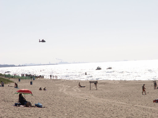
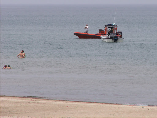
PORTER -- Officials on helicopters and jet skis will continue to search Lake Michigan today for a 13-year-old boy feared drowned Saturday.

Rough waters and strong waves hampered efforts to find the boy, who was reported missing around 1:30 p.m. off of Porter Beach just west of the Indiana Dunes National Lakeshore beach.

Department of Natural Resources officer Shawn Brown said officials would decline to release the boy's name. A recovery operation would continue this morning, he said.

Tina Reid of Porter said she and her friends were getting ready to leave what she called a beautiful day at Porter Beach around 1:30 p.m. when they saw a woman running down the beach, screaming for help.

The woman's young son had seen two other boys in trouble in the water and had actually tried to save them himself, Reid said, but the son couldn't help them and then got his mother for help.

Reid and her friends, Tim and Chris McNally of Porter, swam into the water and were able to save the 10-year-old boy where the water was about 6 feet deep.

"I just heard him keep saying, 'My brother, he's dead,' " Reid said. "I just wish we could have been there 30 seconds earlier."

They couldn't see his brother, though, and Reid ran back to the beach to call 911. By the time she had come back, lifeguards had begun to gather volunteers to search for the boy.

Doris Healy of Porter said she, too, heard the woman scream for help. Her husband, Dennis, went to help and joined the chain of volunteers that tried looking in the shallow waters for the boy.

Officials with the National Lakeshore beach had actually closed the waters to swimming around 11 a.m., Doris Healy said, but people just moved west to the Porter Beach.

"I kept thinking all day this is a horrible day to have kids down here," she said, referring to the rough waves. "I've never seen it this bad."

Dennis Healy said the volunteers eventually had to pull back because of the waves.

Family members watched as officials continued to search the waters for hours. Crews from the U.S. Coast Guard, Ogden Dunes Fire Department, Burns Harbor Fire Department, Porter Fire Department, Portage, Lakes of the Four Season Fire Department and Porter County Sheriff's Police joined the DNR in the search.

People continued to play on the beach and wade into the waters and rescue officials had to save another swimmer around 4:20 p.m. who was in distress in the water.

The woman was sitting and awake when taken away in an ambulance.

Officials closed Porter Beach after that, Portage Assistant Fire Chief Joseph Calhoun said, but people still tried to stay in the water, despite the waves.

"The water was definitely dangerous today," he said.

The search was suspened about 8:30 p.m. because of high waves, DNR officer Brown said.

The most recent Lake Michigan drowning in the region occurred July 13 when Davante Jackson, 14, of Chicago Heights, Ill., disappeared at Kemil Beach in Porter County. His body was found three days later.

RS

Saturday, August 2, 2008

Crews searching Lake Michigan for missing boy

Crews searching Lake Michigan for missing boy

By Jim Pinkerton

PORTER COUNTY — Rescue crews are searching the waters of Lake Michigan looking for a boy who disappeared.

The Department of Natural Resources says it's in recovery mode. The 10-year-old boy was last seen swimming in the water at Porter Beach around 2 p.m. Saturday.

Rescue crews had to suspend diving operations. They say rip currents in the water are just too strong. We'll continue to keep you updated on this developing story.


Photo of search operations off of Porter Beach


Photo by : The AM 1420 WIMS- Robin Storm Team

Friday, August 1, 2008

Where Do Hurricanes Come From?

Where Do Hurricanes Come From?

Once a long time ago in Greece, hurricanes and violent storms were thought to come from the Hecatoncheires. These were three gods, each wielding one hundred hands and fifty heads. They were believed to use this menagerie of body parts to create the destructive powers of a severe storm.

Combined with the Kyklopes brothers, who were the gods/artists who painted the skies with thunder and lightning, the Greeks thought that these severe storms were a punishment of sorts when the gods were angry, or even the results of a battle going on between multiple gods.

It is easy to see how such a story could be believed when you have seen the ultimate destructive capabilities of a hurricane. While the development of an actual hurricane storm is not near as dramatic, it is actually just as interesting.

The Atlantic ocean hurricane season is from June 1 to November 30, while the Eastern Pacific hurricane season is from May 15 to November 30. Tropical hurricanes form only over warm ocean waters of 80 degrees Fahrenheit and above. This is why hurricanes always begin nearest the equator.

Interestingly, the storm's original direction from the equator predicts the direction of the spin of the hurricane. Storms starting in the North spin counterclockwise, while storms starting in the South clockwise. This is all due to how the Earth is rotating on its axis.

The formation of a hurricane is quite simple and complex. It involves the warm moist air from the ocean, which naturally rises upward, much the same as it does in your home when you are trying to heat in the winter. This transference of warm air into the sky creates a low pressure scenario just above the oceans surface.

The warm air that has risen to the sky eventually cools, creating clouds. The continuous motion of warm air rising and cooling creates a swirling motion as new air molecules begin to get pulled into the warm stream. This is where things become a little unknown, or unpredictable if you will.

This occurrence sometimes can create a huge storm in a matter of hours, days, or just fizzle out and have no repercussion at all. This is what makes predicting a hurricane so difficult. Currently we can predict semi-successfully within a two or three day warning to residents within the hurricanes path, but many storms still take us by surprise.

The key to improving early prediction lies within the storms inner-core, and thankfully we are getting closer and closer everyday to cracking that code!

WEATHER NOTE

La. 1 to be closed to traffic if hurricanes approach
Published: Saturday, June 28, 2008 at 8:00 a.m.

HOUMA -- In the event of a threatening hurricane or tropical storm, La. 1, the only road out of both Grand Isle and Port Fourchon, must be closed off in Golden Meadow where the highway exits the levee system, officials said.

A combination of heavy traffic on the road, sinking land and the rush to raise south Lafourche’s levees have left the vulnerable parish with a hole in the system that must be plugged to prevent floodwaters from entering the ring levee.

"There’s a 3-foot dip between the height of the road and the levee," said Windell Curole, interim regional levee director for Lafourche and Terrebonne parishes. "The difference is so much that we think it’s a real risk for flooding."

Officials realized last year that the problem had become severe enough to close the road if a major storm approached. But they did not have to resort to such measures because the relatively calm hurricane season never produced a storm that required it.

Levee District workers will close off the road with Hesco baskets. Used by the U.S. military, the large, wire-mesh baskets are lined with a felt-like synthetic fabric and can be quickly filled with sand to create a barrier.

Each basket is about 6 feet high and 4 feet wide. With the baskets, the road can be closed off in just an hour, Curole said.

The district will try to wait until most people have had the opportunity to evacuate, Curole added, but once there’s water over the road or no more traffic coming through, the district will close the highway.

The district plans to give 24-hour notice of notice prior to setting up the baskets.

"We’re always out there during a storm anyway, and we will have everything ready with the equipment to do it," Curole said. "But if a storm comes in quickly, we’ll do what we have to."

The district only plans to close off the road if a powerful storm like Hurricanes Ivan, Katrina or Rita is expected, Curole said.

Once the baskets are in place, there will be no access in or out of the hurricane protection system.

"It’s an uncomfortable thing to have to do," he added.

Levee officials had become aware of the vulnerability in recent years, Curole said, and hoped to secure state money this year to raise the sinking road several feet and close off the gap.

The district was also hoping to straighten a sharp curve in highway as it exits the levee that’s been blamed for many accidents on La. 1.

"We have been trying to get the state to give us a design on the closure and get some funding to close it off, but now it’s looking like that won’t happen until next year," Curole said.

Significant flood protection needs across the state made it difficult to secure money for the project, Curole added. So the South Lafourche Levee District must improvise protection for another year.

"It’s a little disappointing," Curole said. "We always insisted on having a ramp there instead of a gate so we wouldn’t have to close the road off in the first place, so to have this happen is a disappointment."

Prepare for tornado safety

by Katie Dorsey

As warmer weather becomes a constant for the central Indiana region, residents experience frequent severe weather, including thunderstorms and tornadoes.


In Indiana, tornadoes are most common in April, May, June and July.


Indiana
is situated in an area sometimes prone to violent tornadoes. Although Indiana is not in one of the most violent areas, sometimes known as Tornado Alley, about 6-10 tornadoes occur per every 1,000 square miles in Indiana each year.


"To the best of my knowledge, Indiana gets no more or less strong tornadoes than most other states," David Call said, a meteorology expert at Ball State University. "Approximately 80 percent of tornadoes are F0 or F1, the weakest classes of tornadoes with winds generally less than 110 mph."


Call notes that with F0 or F1 tornadoes, fatalities are very rare


Thunderstorms move through Indiana in late spring and early summer, bringing heavy rains, strong winds and other destructive forces. Thunderstorms form in warm air in front of a cold front that is moving in an eastern direction. The warm air makes the storms more violent. A thunderstorm that is capable of producing tornadoes rotates, and is known as a "supercell."

"Not all supercells form tornadoes, for reasons we don't fully understand," Call said.

When a thunderstorm produces a tornado, the tornado grows in speed and strength due to the warm air surrounding it. Once a tornado has consumed the warm air around it, the tornado dissipates.

In order to remain safe during a possibly violent storm season, residents are advised to take shelter in a stable building in an interior room without windows and to remain in that location until the danger has passed. If you are outside, take shelter in a ditch or other low-lying area.

For more information, check out the interactive below.


MARITIME NOTE

My good freind at Freaque Waves has a MUST READ article for all mariners. His
"A list of freaque wave encounters." is just frightening...

Peril in the age of internet


Two years ago, shortly after I started this blog, I posted an item entitled "A list of freaque wave encounters." That list was later published in the journal Geofizika (Vol. 24 No. 1, 2007) as a professional paper.

In the blog list I included the case of the tanker World Glory which "encountered an abnormally large wave 105 km east of Durban, South Africa, broken in half , and both halves sunk within 4 hours" along with the picture:

which I referenced the site http://www.dynagen.co.za/eugene/freak.html. In the Geofizika publication I used the same URL but not the picture.

Recently Professors Kharif, Pelinovsky, and Slunyaev of Russia are preparing a book "Rogue Waves in the Ocean" to be published by Springer-Verlag Berlin-Heidelberg-New York and wish to include this picture in the book. Unfortunately the acknowledged source is no longer there.

This must be the peril of internet age. Pages on the internet can never be expected to be permanent. People changing jobs and company strorages are limited so internet pages are subject to things like now you see it and now you don't!

Now the proper source of this dramatic picture of tanker World Glory broken in half is in a limbo.

Anyone who owns the copyright, or knows who owns the copyright, of this picture would you please kindly let me know?

The picture is very valuable, dramatic, and historical. For now it may be simply designated as "copyright unknown." But whoever happens to be at the right place and at the right time to be able to capture that historical moment certainly deserves an appropriate recognition and acknowledgment.

Rescue crews issue summer safety alert


Newbiggin lifeboat was launched to rescue two youngsters

MARITIME emergency services issued a summer safety warning yesterday after seven people were rescued from the sea in a week.

Coastguard and RNLI lifeboat officials urged holidaymakers and locals to be constantly on the lookout for potential dangers – and not let a trip to the beach end in tragedy.

On Saturday, a 10-year-old girl was airlifted to hospital by an RAF search and rescue helicopter after she and two other people were helped to safety after being swept out to sea at Embleton Sands in Northumberland.

The previous evening, two children and their pet dog were plucked from rocks at Cresswell, near Druridge Bay, by the Newbiggin lifeboat crew after being cut off by the incoming tide while playing.

And the previous weekend, Newbiggin lifeboat was launched to rescue two youngsters who got trapped by the tide while playing on the village breakwater.

The three incidents have led maritime 999 services to re-emphasise the perils involved in not taking the right precautions when swimming in the sea or playing on the coastline on summer days. A Coastguard spokeswoman said: “It is lovely, hot and sunny at the moment but people must ensure they can get back to the shore safely when they go into the sea. Our advice is to check tide times, make sure someone is watching when you swim and can see you from the shore, don’t get out of your depth and just be generally aware of the hazards involved with the sea.”

Richard Martin, spokesman for Newbiggin’s RNLI lifeboat, said Friday evening’s incident could have ended in tragedy. He said: “The children had been playing on the rocks, with an adult nearby, but the rapidly flowing tide caught out all of them. It is important to appreciate that the tide flows into these areas very quickly and the outcome, but for the actions of the lifeboat crew, could have been much different.”

Saturday afternoon’s incident at Embleton Sands involved a party visiting the area from Sheffield. The coastguard was alerted at 1.40pm that three people were in the sea and were shouting, waving for help and showing signs of being in distress. A local coastguard team, the Craster inshore lifeboat and a Sea King helicopter from RAF Boulmer were sent to the scene, where the three people – two children and an adult – had made it back to the beach with help from a member of the public.

They were exhausted and needed to be assessed by the helicopter crew, who decided to fly the 10-year-old girl to Wansbeck General in Ashington because of her condition. She was checked at the hospital and later allowed home.

On Friday, the two children and their dog were playing on rocks at Cresswell Scarrs at 6pm when the speed of the incoming tide caught them unawares and cut off their escape route to the shore. Their mother called the coastguard for help and Newbiggin’s Atlantic 75 lifeboat crew carried the youngsters off the rocks and took them ashore.


Messing About In Ships Podcast

Let me also introduce a new member of the Robin Storm Team. Visit Cap's site....

Art Of Dredging


Have a Great Weekend!
RS

Thursday, July 31, 2008

Researchers Hope New Technology Can Increase Warning Times, Save Lives

Researchers Hope New Technology Can Increase Warning Times, Save Lives

Researchers Hope New Technology Can Increase Warning Times, Save Lives

By ASHLEY PHILLIPS and NED POTTER

July 25, 2008 —

As a record-breaking and increasingly deadly tornado season wreaked havoc across middle America this summer, researchers have been testing a new, high-tech radar system that could help forecasters better pinpoint when, where and how a twister  or any other storm for that matter  will strike.

The United States has the most powerful radar network in the world -- a national system called NEXRAD. But even so, the average tornado warning comes only 12 minutes before the storm strikes -- and three quarters of the warnings are false alarms.

"We don't want to have people who are waiting 10, 15, 20 minutes, and then nothing happens," said Kevin A. Kloesel, associate dean of the College of Atmospheric and Geographic Sciences at the University of Oklahoma.

To that end, university researchers, in conjunction with the National Oceanic and Atmospheric Administration, which runs the National Weather Service, have been quietly testing a new high-tech system of radars that can see what current NOAA radars can't: storm activity that is close to the ground.

"The National Weather Service operates a radar network and those radars are located hundreds of miles apart. They cover huge areas, are large and do surveillance scanning over the area they cover," Kloesel said. "The problem with large scanning radar is that the farther you look out  when you send a beam straight out, the Earth is actually curving away from it as you get farther and farther away. When you get 90 to 100 miles out, that beam is sensing the storm at 8,000 to 10,000 feet."

According to Kloesel, who has worked on the project since it began six years ago, earth curvature creates an "umbrella" close to the ground that radars can't see; this new system, called Collaborative Adaptive Sensing of the Atmosphere (CASA), is designed to look under that umbrella, where severe weather, like tornadoes, and hail actually form.

In order to achieve that, CASA is built around a system of radars that are low to the ground, on cell phone towers, for example, and scan smaller areas.

"We see what's going on down low much better than you can with the existing technology," Kloesel said.

Unlike existing weather radars, however, the CASA radars also communicate with one another, so if a tornado is tearing through an Iowa town for example, the radars can communicate with each other and follow it as it travels its path instead of continuing to examine random areas that aren't experiencing any storm activity.

"The current system of radars [doesn't] interact with one another. It just sits and spins," Kloesel said. "[With CASA], you can have multiple radars sensing the same storm. They work in many instances like air traffic controllers."

Kloesel doesn't view CASA as competition for current radar technology, but rather a great way for NOAA to get an even clearer picture from both the ground and the air of what's happening in a storm.

"Storms are three-dimensional, so even though a storm might be producing a tornado, the current technology is going to [only] give us a good look at what's going on in the upper part of that atmosphere," he said.

CASA could be especially helpful in areas that are prone to severe weather, like Houston, a city that often floods  the radars can accurately report rainfall  or other rain-related activity, in any part of tornado alley.

Another area where CASA could help? With warnings. Currently, the National Weather Service only delivers warnings when a tornado is detected. When a tornado warning is issued, for example, residents have an average of 12 minutes before the tornado hits. Some storm victims had even less than that. Like residents in Iowa and neighboring Kansas on June 11, when a series of tornados swept through. Four people were killed at a Boy Scout outing in Iowa, where some survivors said they had only three or four minutes notice.

Currently, before issuing a warning, the weather service often issues a less imminent tornado watch, that usually covers a wide area that experts say too many residents ignore.

"Sometimes people have to take a little more care," said Penn State meteorologist Jay Searles. "If people aren't able to look and take a little personally responsibility, it is a little hard to do. Educating yourself can really aid or help prevent disasters from happening as far as loss of life."

With CASA on the other hand, forecasters could do a "warning on forecast" model. Because the radars are watching what's happening with weather so close to the ground, forecasters would be able to issue warning with pinpoint accuracy up to two hours ahead of time where and when a tornado is likely to strike, according to Kloesel.

"We hope to be able to lower the false-alarm rate from the current 75 percent, maybe down to 10 or 20 percent," said Kelvin Deoegemeier, a professor of meteorology at the University of Oklahoma.

The study is facing a funding review from the National Science Foundation later this year and questions of infrastructure and cost are likely to be asked, said Kloesel, who declined to give cost estimates, saying they were out of date and not ready to be published. But whatever the cost, he says that as far as the researchers are concerned, the system is ready to be used.

"When you visit other states -- Texas, Wyoming -- they're clamoring for radars like this," said Jerry Brotzge, operations director for the CASA project at the University of Oklahoma. "They're willing to pay out of their own city money to buy a radar like this."

WEATHER NOTE

Tornadoes: Basic What-To-Dos
Tornadoes are the most violent storm and one of Earth's most dangerous catastrophes. Whirling winds usually exceed 100mph and can reach speeds of 300mph. An average of 1,000 tornadoes spin up beneath thunderstorms in the USA each year.

Tornadoes can occur any time of the year but they are most rampant during USA's spring season because spring brings favorable tornado conditions.

The National Weather Service's Glossary of Meteorology defines a tornado as "a violently rotating column of air in contact with the ground and pendant from a thunderstorm." The thunderstorm is the first step in the formation of a tornado. If other weather conditions are right, the thunderstorm will spin out more tornadoes and cast catastrophe in land.

In the US, it damages the central and mountain state areas stretching from Texas to Nebraska. These states include Iowa, Colorado, Indiana, Illinois, Missouri, Oklahoma and Arkansas (known as Tornado Alley). In fact, tornadoes have already occurred in other states in the East Coast and West Coast but not as violent as what is normally occurring in the central and mountain states.

The six-tiered Fujita Scale ranks the damage that tornadoes make. F0 and F1 tornadoes on the scale are considered “weak” causing minimal to moderate damage with winds from 40-12 mph. F2 and F3 tornadoes are considered strong, packing winds of 113-206 mph that can cause major, severe damage. F4 and F5 tornadoes are classified with winds exceeding 206 mph.

Weak tornadoes travel in short distances for 10 minutes or less. Violent tornadoes, however, lasts for hours and can travel more than 100 miles.

Tornadoes can come without warning but there is always a tornado warning. Tornado warning means that a tornado has been sighted. If it is issued in your area, seek underground storm shelter immediately and bring emergency necessities like aid kits and important documents. Aid kits – first aid items, water, food, flashlight, transistor radio, batteries, and waterproof containers. Important documents – an inventory of your belongings, appliances, furniture, fixtures, for insurance purposes, and documents like birth certificates, etc.

BEFORE THE TORNADO…

Know the signs of a tornado: Weather forecasting science is not perfect and some tornadoes do occur without a tornado warning. There is no substitute for staying alert to the sky. Besides an obviously visible tornado, here are some things to look and listen for: strong, persistent rotation in the cloud base; whirling dust or debris on the ground under a cloud base -- tornadoes sometimes have no funnel; Hail or heavy rain followed by either dead calm or a fast, intense wind shift. Many tornadoes are wrapped in heavy precipitation and can't be seen; Day or night - Loud, continuous roar or rumble, which doesn't fade in a few seconds like thunder; Night - Small, bright, blue-green to white flashes at ground level near a thunderstorm (as opposed to silvery lightning up in the clouds). These mean power lines are being snapped by very strong wind, maybe a tornado; Night - Persistent lowering from the cloud base, illuminated or silhouetted by lightning -- especially if it is on the ground or there is a blue-green-white power flash underneath.

And lastly, have a family tornado plan in place. Flying debris are an added danger along tornadoes. When a tornado watch is issued, think about the drill and check to make sure all your safety supplies are handy. Or immediately check your storm cellar if you have available supplies down there.

DURING THE TONADO…

Forget about the old notion of opening windows to equalize pressure; the tornado will blast open the windows for you!

The safest place to be during a tornado is underground. If there's hurricane safe room in your home, a small room in the middle of house -- like a bathroom or a closet -- is best. The more walls between you and the outside the better.

AFTER THE TORNADO…

Keep your family together and wait for emergency personnel to arrive. Carefully render aid to those who are injured. Stay away from power lines and puddles with wires in them; they may still be carrying electricity! Watch your step to avoid broken glass, nails, and other sharp objects. Stay out of any heavily damaged houses or buildings; they could collapse at any time. Do not use matches or lighters, in case of leaking natural gas pipes or fuel tanks nearby. Remain calm and alert, and listen for information and instructions from emergency crews or local officials.

MARITIME NOTE

They sought shelter but the sea took them

The storm wrecked the San Cuvier and killed two of the crew. Photo / Alan Gibson

The skipper who lost his life when his fishing boat ran aground in treacherous seas yesterday was an experienced seaman who had lived through many violent storms.

Eric Barratt, managing director of Sanford, which owned the stranded San Cuvier, told the Herald last night the man and his crew had attempted to launch the liferaft at Haurere Pt near Opotiki when it became clear the boat would run aground.

The two men who died have not been named, nor have the two crew members who survived.

A minute's silence was held at the fish market in Auckland this morning to mark the deaths.

A 16-year-old from Auckland was in a stable condition in the surgical unit of Whakatane Hospital yesterday and a second man, also from Auckland, was treated for hypothermia and discharged.

Their two colleagues were among four people thought to have lost their lives in weather-related incidents over the weekend.

James Moore, 33, died when his outrigger canoe hit rough waters off Mt Maunganui on Saturday afternoon.

He had left Maketu with three friends and went missing in the rough seas. His body was recovered yesterday.

The fourth storm victim is a 38-year-old man who died in a house fire at Meremere in the Waikato which is believed to have been started by a candle after a power cut.

The crew of the San Cuvier had managed to set off a distress beacon at 3.30am yesterday from their location 11km east of Opotiki, but did not have time for a mayday call.

The survivors were picked up by helicopter about three hours later. The body of one of the men was recovered but the second was swept out to sea. A second attempt to recover his body is to be made this morning.

Mr Barratt said the San Cuvier was normally based in Auckland but was making trips from Tauranga. The ill-fated voyage was to have lasted four or five days, he said.

He did not know what had happened to cause the boat to run aground and wasn't sure if weather warnings had been received. There would be an investigation.

"We had several vessels out and once the storm warning came, they got to shelter. We fish all through the year and when storms come along, the vessels take shelter," said Mr Barratt.

Eyewitness Margaret Thompson, who lives at Haurere Pt, told the Herald the men were trying to take their boat out again after coming ashore to shelter from the storm.

Two of the four were rescued from rocks nearly three hours after setting off the distress beacon.

She had invited one of the survivors into her home to "keep warm by the fire and have a hot drink while he waited" for the helicopter to finish searching.

Maritime NZ spokeswoman Shona Brown said emergency services initially had some trouble tracking the emergency beacon from the vessel.

"The boat was under some rocks and the satellite system may have found it difficult to find it because of that."

A fixed-wing plane found the boat shortly after heading into the air about 5.50am, and the helicopter arrived about 6.30am.

RS

Wednesday, July 30, 2008

Dust Storms In Sahara Desert Sustain Life In Atlantic Ocean

Dust Storms In Sahara Desert Sustain Life In Atlantic Ocean

ScienceDaily (July 19, 2008)
Research at the University of Liverpool has found how Saharan dust storms help sustain life over extensive regions of the North Atlantic Ocean.

Working aboard research vessels in the Atlantic, scientists mapped the distribution of nutrients including phosphorous and nitrogen and investigated how organisms such as phytoplankton are sustained in areas with low nutrient levels.

They found that plants are able to grow in these regions because they are able to take advantage of iron minerals in Saharan dust storms. This allows them to use organic or ‘recycled’ material from dead or decaying plants when nutrients such as phosphorous – an essential component of DNA – in the ocean are low.

Professor George Wolff, from the University’s Department of Earth and Ocean Sciences, explains: “We found that cyanobacteria – a type of ancient phytoplankton – are significant to the understanding of how ocean deserts can support plant growth. Cyanobacteria need nitrogen, phosphorous and iron in order to grow. They get nitrogen from the atmosphere, but phosphorous is a highly reactive chemical that is scarce in sea water and is not found in the Earth’s atmosphere. Iron is present only in tiny amounts in sea water, even though it is one of the most abundant elements on earth.

“Our findings suggest that Saharan dust storms are largely responsible for the significant difference between the numbers of cyanobacteria in the North and South Atlantic. The dust fertilises the North Atlantic and allows phytoplankton to use organic phosphorous, but it doesn’t reach the southern regions and so without enough iron, phytoplankton are unable to use the organic material and don’t grow as successfully.”

Professor Ric Williams, co-author of the research, added: “The Atlantic is often referred to as an ‘ocean desert’ because many nutrients, which are essential in plant life cycles, are either scarce or are only accessible in the darker depths of the ocean. Plants, however, need some sunlight in order to absorb these important nutrients and so can’t always access them from the ocean depths. They therefore need to find the nutrients from elsewhere. Now that we are able to show how cyanobacteria make use of organic material we can understand more clearly how life is sustained in the ocean and why it isn’t an ‘ocean desert.’

“These findings are important because plant life cycles are essential in maintaining the balance of gases in our atmosphere. In looking at how plants survive in this area, we have shown how the Atlantic is able to draw down carbon dioxide from the atmosphere through the growth of photosynthesising plants.”

The research is published in Nature GeoScience.

The study also involved scientists at the National Oceanographic Centre, Southampton and the Plymouth Marine Laboratory. The work was funded by the UK Natural Environment Research Council.

WEATHER NOTE

Powerful dust devil suspected in death

Associated Press - June 21, 2008 3:45 PM ET

CASPER, Wyo. (AP) - Meteorologists in Casper believe a strong dust devil is probably what blew over a 1,000-pound shed and killed a South Dakota woman this past week.

A micro burst was initially suspected in the accident that killed Jennifer Job-Massa, of Sioux Falls, S.D.

But National Weather Service meteorologist Chris Jones says a micro burst is usually a mile or more across and would most likely have caused other damage in the area.

Jones says a dust devil, or whirlwind, can have the similar effect of a tornado on a much smaller scale.

Authorities believe the 60-to 80-mph winds in the dust devil toppled the shed Wednesday as Job-Massa likely sought shelter behind it.

Waterspout Forms Off Deerfield Beach

DEERFIELD BEACH (CBS4) ― Beachgoers on Deerfield Beach had quite a sight Tuesday morning when a waterspout formed just offshore.

The short-lived waterspout was spotted around 10:00 a.m. It lingered there for a few minutes and didn't move much before it dissipated.

A few showers or storms could make it onshore throughout the morning and early afternoon hours, but no severe weather is anticipated.

Waterspouts can easily overturn boats and create locally hazardous seas. According to the National Weather Service, the best course of evasive action if threatened by a waterspout is to move at a 90 degree angle from its apparent movement. Seek safe harbor immediately.

(© MMVIII, CBS Broadcasting Inc. All Rights Reserved.)

MARITIME NOTE

Though the Compact is signed, Great Lakes are still at risk

THE Great Lakes Compact took 10 years to write and pass, generated a thousand adoring news releases, and now goes off to Washington for what the region hopes is quick approval by Congress. Great work, right? Not so fast - let's look past the self-congratulatory press releases.
Advertised as a guarantee of "a future in which the Great Lakes are forever sustained" (Gov. Ted Strickland of Ohio), "a strong regional warning to chronically dry regions of the South and West" (Chicago Tribune), and "something that will protect the Great Lakes for generations to come" (Wisconsin state Sen. Scott Gunderson), it's actually a way for bottled-water companies to gain rights to sell Great Lakes water.

What's the problem? Doesn't this pact set standards to limit or deny major Great Lakes diversions? Yes, for the most part through a pipe, but not in small containers. Also not addressed is the connection between groundwater and the Great Lakes. Groundwater is tied to the Great Lakes, supplying much of their flow.

To understand the biggest problem, it's important to remember how the whole thing got started 10 years ago.

In May, 1998, it suddenly became known through media reports that the Ontario Ministry of Natural Resources granted a permit to a private firm, the Nova Group, that wanted to ship up to 50 tanker vessels of Lake Superior water each year to unidentified private customers in Asia.
Turning Great Lakes water into a product - especially the water of Lake Superior, the purest and coldest of the Lakes - fueled indignation among citizens on both sides of the international border. Chastened after public hearings and media scoldings, the Nova Group gave up its permit, and Lake Superior was given a reprieve.

To prevent the Great Lakes from ever being shipped out as a commercial product, the eight states plus Ontario and Quebec began drawing up a binding agreement to prevent it. But something happened in the 10 years it took to produce that agreement.

Instead of banning the conversion of the Great Lakes to a product, the Compact promotes selling it in small containers. The agreement allows pumping and packaging of Great Lakes water - in the hundreds of millions of gallons per project per year - as long as the packages are 5.7 gallons or less in volume. Michigan has already allowed this practice. Any of the eight Great Lakes states could have closed the loophole within their borders. None have.

It's not an accident that an agreement designed to forbid water exports from the Great Lakes by private entrepreneurs now condones them. The bottled-water industry, not a serious economic force in 1998, burst on the scene, lavished its favors on elected officials, and is now slurping up the benefits.

In the Ohio General Assembly, conservative compact opponents held up the agreement by requiring a vote on a state constitutional amendment that will give more ammunition to private interests who want to draw down Great Lakes and Ohio River groundwater. "The government is being encouraged to take people's property without paying for it," said State Sen. Timothy Grendell. "That is flat-out un-American."

The irony is that the compact and Ohio's proposed state constitutional amendment may confer a new private property right - to Nestle and other giant water-for-sale companies. That's something few Great Lakes citizens, but many Great Lakes lobbyists, can go for.

Under centuries of common law and common sense, water has been regarded as a publicly owned resource, too important for navigation, fishing, and ecology to be privatized. The compact turns that upside down and puts the essence of life up for sale to private parties. That is un-American.

Michigan, the Great Lakes State, generated its share of bubbly news releases when its compact approval and related legislation was signed into law by Gov. Jennifer Granholm on Wednesday. But its water conservation laws remain some of the weakest in the region. They allow the draining of up to 25 percent of a stream, don't subject most major water withdrawals to any state approval, and lack funding for implementation and enforcement. And, for the second time in three years, the state has affirmed that a torrent of water flowing out of Michigan in high-priced containers is not actually an export barred by law.

The Great Lakes won't be lost tomorrow. But they won't be saved by the compact the day after tomorrow. It's time for the people of the Great Lakes region to assert their common ownership and control of the water that feeds them and the lakes. It will take a pitched battle and vast persistence in every state to make it happen.

The clock is ticking. Water is the resource that will bring economic opportunities to the Great Lakes region. The lakes contain 95 percent of U.S. and 18 percent of the world's surface fresh water. It makes no sense to sell them off in boatloads or truckloads of bottles.

One Michigan newspaper said, "Without the compact, the region's water could be put at risk." The problem is that with the compact, the region's water remains at risk and in some ways may be in greater danger than before. The work of assuring that the Great Lakes are not exported and drained is only beginning.

Dave Dempsey is author of "Great Lakes for Sale," published by University of Michigan Press this year. He was environmental policy adviser to Gov. James Blanchard of Michigan from 1983 to 1989.


RS

Tuesday, July 29, 2008

NOAA Reminds Beachgoers That Rip Currents Can Be a Threat

NOAA Reminds Beachgoers That Rip Currents Can Be a Threat

Heading to the beach for summer vacation? NOAA is urging beachgoers to learn how to “Break the Grip” of rip currents before getting into the water. Rip currents are a deadly threat — accounting for more than 80 percent of lifeguard beach rescues.

Rip currents are narrow channels of fast-moving water that pull swimmers away from the shore. They can occur at any beach with breaking waves, including the Great Lakes.

Moving at speeds of up to eight feet per second, rip currents can move faster than an Olympic swimmer and can easily overpower a victim. Panicked swimmers often incorrectly swim straight back to shore — putting themselves at risk of drowning because of fatigue.

If caught in a rip current, don’t fight it! Swim parallel to the shore and then swim at an angle – away from the current – toward shore.

“We have a constant education campaign about rip currents since many people visit the beach infrequently and may be unfamiliar with this leading surf hazard,” said Timothy Schott, meteorologist with NOAA’s National Weather Service Marine and Coastal Branch in Silver Spring, Md. “This year, we have developed bilingual English-Spanish signs to reach a wider audience with life-saving instructions on how to break the grip.”

"Rip currents can be killers. The United States Lifesaving Association estimates that the annual number of deaths due to rip currents on our nation's beaches exceeds 100,” said Peter Davis, president of the Gulf Coast Region of the United States Lifesaving Association and chief of the Galveston Island Beach Patrol. “The greatest safety precaution that can be taken is to recognize the danger of rip currents and always remember to swim at beaches with lifeguards."

NOAA also offers the following safety tips:

  1. Swim at lifeguard-protected beaches.
  2. Never swim alone.
  3. Speak to on duty lifeguards about rip currents and other expected water hazards.

Many coastal National Weather Service offices issue what's known as Surf Zone Forecasts that provide a low, moderate or high description of rip current risk. All NOAA National Weather Service offices include moderate to high risk of rip currents in their Hazardous Weather Outlook. These forecasts are available online at www.weather.gov.

More safety tips and educational materials are free and available to download at http://www.ripcurrents.noaa.gov/.

The National Oceanic and Atmospheric Administration, an agency of the U.S. Commerce Department, is dedicated to enhancing economic security and national safety through the prediction and research of weather and climate-related events and information service delivery for transportation, and by providing environmental stewardship of our nation's coastal and marine resources. Through the emerging Global Earth Observation System of Systems (GEOSS), NOAA is working with its federal partners, more than 70 countries and the European Commission to develop a global monitoring network that is as integrated as the planet it observes, predicts and protects.

RIP CURRENTS FOR REAL

BunnyERabbit
On July 13th 2008, 15 year old Chicago youth Devant Jackson was swept away from Kimel Beach at the National Lake Shore Park in Indiana. On July 16th his body was recovered. Recovery Photo by Team Robin Storm.Delete caption

WEATHER NOTE

Extra 3 trillion gallons of water in Lake Michigan Lake Michigan's water level has risen 8 inches above the same period a year ago. Once just 6 to 12 inches above all-time lows, lake levels are up in response to the same downpours that caused many area rivers to flood. The U.S. Army Corps of Engineers, which monitors the Great Lakes, predicts the higher levels are to hold through the coming months, though, barring new waves of heavy rains, the biggest rises have probably already occurred. Interconnected Lakes Michigan and Huron are unlikely to change significantly in the next month.

The corps reports other Great Lakes have experienced increased levels as well, with Lake Superior 16 inches higher than a year ago. The rise in Lake Michigan means the lake has added approximately 3.12 trillion gallons since a year ago.

Blistering heat continues to grip the southern Plains. The heat has anchored northwest jet-stream winds over the area, which have slowed the eastward expansion of hot air in recent months.

MARITIME NOTE
FROM THE DECK OF gCAPTAIN.....

Windoc Incident - Story Behind YouTube’s Most Chilling Video

July 21st, 2008 ·

<span class=Windoc Damaged and at anchor after collision and fire"
The Windoc blocks the canal. Alex Howard

In August 2001 the Bulk Carrier Windoc was lined up on the Welland Canal’s Bridge 11 in Ontario Canada. After recieving the flashing amber approach light indicating that the bridge operator was aware of the vessel the captain lined up on the centerline and maintained a speed of 5 knots. Minutes later while the vessel was half way through the bridge started descending.

A Time for Restraint: Maritime Disasters Usually Not What They Seem… A Time for Restraint: Maritime Disasters Usually Not What They Seem…

Cosco Busan case and a new crisis on the Mississippi River attracting speculation and needless drama – and sometimes, grandstanding.

I briefly considered putting together a couple of news articles regarding either the latest Cosco Busan case developments or the Mississippi River for the online edition this week, but what passes for "fact" seems to change so fast that I am quite sure I'd get it wrong. Hence, I'm going to let others make suppositions and prognosticate about what happened, didn't happen or who is to blame. However, that won't stop me from wondering if those who have continuously excoriated Captain John Cota in the news might just be backpedaling a notch or two.

In the latest twist out west, the Cosco Busan operator is now accused of fabricating records to hinder the NTSB and DOJ probes of the November 2007 allision in San Francisco Bay (see the USDOJ press release elsewhere in this e-newsletter). I don't know who else can be charged for what else, but it is getting pretty hard to follow along without a scorecard. To say that this has been the most bizarre set of circumstances I have ever witnessed in relation to any maritime accident would be a gross understatement. I've said it once before and I'll reiterate for you again: I'm not going to make any suppositions or predictions in this case.

Too often, we in the maritime industry are collectively quick to come to conclusions in any matter brought before us. I know that I received scores of "submitted articles" in the months that immediately followed the Cosco Busan allision, each purporting to know what went wrong, how and who was to blame. I'm glad that, at least in this case, I largely refrained from piling on or providing a venue for these papers. The only thing that I am sure of right now is that a great deal went badly wrong on that day and that the end result of all of it is going to be painful for a lot of people, companies, the environment and the list goes on…

Further east, on the mighty Mississippi River, a Liberian-flagged oil tanker collided with a US-flagged fuel barge near downtown New Orleans on Wednesday morning. According to official sources, as much as 375,000 gallons (8928 barrels) of oil spilled from the barge into the river. The incident resulted in the partial closure of one of the nation's most important waterways as a massive response was organized. The NTSB announced that they had an investigative team on the way at about the same time that the Coast Guard reported, "Representatives from the tug boat, Mel Oliver, report that there were no properly licensed individuals on the vessel during the time that the incident occurred."

It is again tempting to write my own piece about the Mississippi River collision and related oil spill, but I think I'll pass again. For example, I'm quite sure that any number of people will now speculate about the absence of "licensed individuals" on the vessel at the time of the collision. Like the Cosco Busan casualty, however, you can be sure that the general public – like you and I – are only looking at the tip of the iceberg in terms of the facts. At this point, the best any of us can do is look at the official news releases and get out of the way. There is serious work to be done.

In his AM e-newsletter today, Holland & Knight's Dennis Bryant succinctly outlined events happening on the Mississippi River and also told his readers, "The pressure on the Coast Guard will be intense due to the economic impact of the closure. Please be assured that everyone will be working on completion of this mission will all due dispatch. Now is not the time to divert resources to respond to inquiries from the media and others that can await a more in-depth analysis." I think that's pretty good advice.

In contrast, another press release, this time from a well-known Washington politician, characterized the Mississippi River incident as "Nothing Less Than a Tragedy." This gem of wisdom came from Congressman Elijah E. Cummings (D-MD), who also reassured all of us that "…my colleagues on the Subcommittee and I will be thoroughly examining the causes leading up to this devastating event." Well, duh. Cummings also said that it was his hope that "the members of the U.S. Coast Guard will approach this incident with the same effectiveness and efficiency that was demonstrated in the aftermath of Hurricane Katrina, and I will be in close communication with them to ensure that this is the case."

I don't know about you, but I'm not going to sleep better tonight knowing that a Washington politician will be micromanaging the very people that are responding to this incident and spill. And, as others have said far better than I could do it, "Now is not the time to divert resources to respond to inquiries from the media and others…" The temptation to grandstand in these situations is enormous, especially when there are points to be scored. It's a little like having an aspiring presidential candidate fly into the middle of a disaster for a photo opportunity. Instead, I think we should all keep our eyes on the ball; and by that I mean, let the Coast Guard do their job unencumbered and the investigators sort out the mess.

Joseph Keefe is the Managing Editor of THE MARITIME EXECUTIVE. He can be reached with comments and/or questions on this or any other article in this newsletter at jkeefe@maritime-executive.com.


RS

Monday, July 28, 2008

Satellite View Of Cloud Tops Might Warn Of Storms

Satellite View Of Cloud Tops Might Warn Of Storms

ScienceDaily (July 11, 2008)
For three years, a new way to use data collected by NOAA weather satellites has been giving North Alabama short-term warnings of "pop-up" thunderstorms.

Developed by scientists at The University of Alabama in Huntsville, this new computer program is now spreading to other parts of the U.S. and the world. Later this summer a version of the UAHuntsville weather program will begin forecasting storms throughout Central America, Southern Mexico and the Dominican Republic.

The UAHuntsville Satellite Convection AnalySis & Tracking System (SATCASTS) monitors cumulus clouds as they develop, move and grow through time, according to the person who brainstormed the idea behind the program, Dr. John Mecikalski, an assistant professor of atmospheric science at UAHuntsville.

The program uses data from NOAA’s GOES weather satellites to provide 15-minute to one hour warnings of local thunderstorms. This is the first time forecasters anywhere have had a tool to forecast storms that develop locally. This differs from Doppler radar, which only tracks rain after it starts to fall.

"The radar tells you what's happening, but not what's going to happen," said Wayne MacKenzie, a research associate in UAHuntsville's Earth System Science Center and a member of the SATCASTS development team.

Operated by UAHuntsville scientists for the National Weather Service forecast office in Huntsville for about three years, SATCASTS has been accurate in its storm forecasts between 65 and 75 percent of the time. It has successfully identified hazards generated by thunderstorms, including lightning, hail, high wind, flash floods and turbulence.

Mecikalski got the idea for SATCASTS in 2001, when he was affiliated with NOAA’s Cooperative Institute for Meteorological Studies. He was looking for a way to determine which of the thousands of cumulus clouds present on any given summer afternoon will become thunderstorms. (One percent or less of clouds develop into rain clouds.) He has continued his research since joining the faculty at UAHuntsville in January 2004.

Using data from the GOES visible and infrared sensors, SATCASTS tracks changes in both cloud temperature (height) and water vapor. This data is updated every 15 minutes.

The UAHuntsville team has determined that one of the most important factors in predicting thunderstorms is temperature change. If the top of a cloud cools by 4 C (about 7.2 degrees Fahrenheit) or more in 15 minutes, that means the cloud is growing quickly and there is a growing probability of rain beginning within 30 minutes to an hour. A 4 C drop in temperature typically means a cloud top has climbed between 1/4 to 1/3 of a kilometer.

Based on its success in the Huntsville forecast office, scientists at UAHuntsville are working with the National Weather Service to transition SATCASTS into the storm prediction systems in forecast offices in Birmingham, AL, and Nashville, TN, as well as both Melbourne and Miami, FL.

The UAHuntsville team is also working with NASA and the Federal Aviation Administration (FAA) to test SATCASTS' possible utility in aviation and air traffic control. The system is being tested at the FAA’s New York City air traffic control center. If successful, SATCASTS might be used worldwide to warn pilots of storms, turbulence and other weather threats before they occur.

Other organizations evaluating the operational implementation of the SATCASTS algorithm include the European Meteorological Satellite agency and the South African Weather Service. Discussions are also under way to bring SATCASTS capabilities to East Africa.

While SATCASTS joins a sophisticated and extensive network of weather monitoring systems in the U.S., it is expected to have special value in regions where storm forecasting and monitoring have been limited or non-existent. The system is relatively inexpensive to install and operate, since it uses freely distributed weather data from existing satellite sensors.

NOAA-funded research at UAHuntsville will focus on expanding SATCASTS' capabilities. In areas where Doppler radar networks do not exist, SATCASTS might be used in the future to track frontal storm systems and provide severe weather warnings that are not presently available, Mecikalski said.

"This makes SATCASTS and satellite-based rainfall predictions very relevant in many developing countries, when ground-based radar is absent but high quality satellite data are in place."

The UAHuntsville SATCASTS team includes Mecikalski, two other scientists and three graduate students. The project has been supported by more than $1 million in funding from NOAA, NASA and the FAA.

Research on improving SATCASTS is ongoing and is expected to continue for at least five years. New areas of research include 30-to-90-minute lightning and flash flood forecasts.

The UAHuntsville team is also working on a next generation SATCASTS, which will take advantage of the improved sensing systems that will be available when NOAA launches it GOES-R series of satellites beginning in 2016. Sensors on those satellites will collect data in more channels, more often and at higher resolution.

WEATHER NOTE

Thunderstorms and Camping Safety

When folks go camping, whether into the wilderness or just locally, they have to be prepared to deal with whatever weather happens to be going on during their campout. If you've done any camping at all, chances are you've experienced a few thunderstorms, up close and personal in a tent, or while hiking and otherwise enjoying the outdoors.

It's my "day job" to be involved in hazardous weather, mostly from thunderstorms. Thunderstorms have a beneficial side, but on some occasions, they become more than a minor inconvenience for campers and those involved in outdoor activities. Through my Scouting experiences, I've had many opportunities to see how young people and their adult leaders operate during a campout.

Teenage boys are legendary for trying to act "macho" and getting stuck in situations that have become dangerous. Unfortunately, adult leaders sometimes can be just as silly and ignorant as the boys. It's often said "What you don't know can't hurt you." Absolutely wrong!! Ignorance and macho trips can result in terrible tragedies once in a while, and I doubt that anyone would want that on their conscience.

Lightning hazards

Thunderstorms all produce lightning in varying amounts ... sometimes there's just an odd flash or two ... other times, the storms produce lightning nearly continuously, with lots of flashes to ground. It's the flashes from the cloud to the ground (CG flashes, for short) that create problems. They typically are only a small percentage of the total flashes produced by a thunderstorm; most lightning stays within the clouds. But it only takes one CG flash to get you! The human body is basically a bag of salty water, which conducts electricity a lot better than air, so the lightning will often try to travel through you to reach the ground.

Lightning and thunder are so common as to seem just part of the background. Often, as children, lightning and thunder frighten us. As young people mature (especially boys), it becomes a "macho" thing to show they are not afraid of a thunderstorm. Well, I'm certainly not advocating that we over-react, and head for home at the first sign of any thunderstorm ... but I want to suggest that we not go to the opposite extreme and pay virtually no attention to the threat that lightning strikes pose. Any thunderstorm should be a matter of concern, and the campers should already know what to do if the situation becomes hazardous.

It's pretty unlikely that you'll ever be struck by lightning. Scientists cannot make accurate predictions of when and where lightning will strike or how often, so for all practical purposes, it looks pretty random. Nevertheless, more people are killed by lightning year in and year out than by any other weather phenomenon; typically on the order of 100 people or so annually in the United States. Furthermore, lightning does not have to kill you to create major problems in your life. Several hundred people are affected by lightning in the U.S. every year, short of being killed. To get some idea of the non-fatal hazards of lightning from a medical point of view, check out this site and/or this one. Being struck is no joke and can affect you adversely for the rest of your life.

Anytime you're outdoors, you've increased your risk of being struck by lightning. For example, some golfers are struck every year ... many of you may have heard the story of Lee Trevino's non-fatal encounter! Another category of those who are at relatively high risk includes those who climb mountains. Since a lot of wilderness adventure camping includes hiking and camping at high elevations, campers and hikers are considerably at risk, whether they realize it or not. Consider the following statement from the 1997 Philmont Scout Ranch "Guidebook to Adventure": READ MORE

MARITIME NOTE

PRINCESS OF THE STARS : ‘You’re better off texting coordinates’

MANILA, Philippines—The ill-fated MV Princess of the Stars had all the fancy communications systems in the world, but for some weird reasons they all failed when they were needed, except for an antiquated single side band radio and the ubiquitous cell phones.

That’s the contention of Ernelson Morales, safety officer of Sulpicio Lines Inc.

The device that automatically submits a distress signal via satellite didn’t work.

There was no SOS received by maritime agencies or ships that could have immediately gone to the aid of the 860 people aboard the vessel only 56 of whom survived.

The ship also had a Navtex, used to get weather reports from nearby countries, Morales says. But Sulpicio chose to rely on the single side band radio and the cell phone to get reports from the Philippine Atmospheric, Geophysical and Astronomical Administration (PAGASA). Its weather data are more localized, he says.

In addition, the ferry had a medium-frequency, a high-frequency (HF) radio and a very-high-frequency (VHF) radio along with a two-way radio tuned in to the emergency channel and an emergency position indicating radio beacon (EPIRB) that, once immersed in three meters of water, would automatically send a distress signal.

These were all required by maritime regulations, Morales says. “You won’t be allowed to sail if you don’t have complete equipment,” he said.

But apparently, these communication systems proved unreliable when the vessel was getting the brunt of Frank’s fury.

He theorizes that the strong winds damaged the antennas and transmitters, thus rendering the vessel incommunicado.

A distress signal sent by the EPIRB, installed outside the bridge on the top deck, would have been picked up by nearby countries with the capability to receive such data.

Winds knocked out system

“I was wondering why it did not send a signal. My presumption is, since it is outside, the strong winds knocked it out of its position and sent it hurtling against a wall, thus breaking it. That’s the only way for it not to send a signal because it’s automatic,” Morales says.

Sulpicio Lines senior vice president Edgar Go told the Board of Marine Inquiry (BMI) that the company used the single side band and cell phone to communicate with the ship captain during the emergency.

Retired Commodore Amado Romillo, who resigned from the BMI after being accused of being biased by Sulpicio, criticizes the ship’s reliance on the single side band radio to communicate with the ports.

Romillo also says there were hours when nobody was manning Sulpicio’s radio at the port.

The Philippine Coast Guard only has VHF and HF radios and has also taken to relying on cell phones, says PCG spokesperson Lt. Armand Balilo.

“As far as I know, the Philippine authorities have no capability to get the signal from EPIRB. Sometimes we ask, what’s the need for this EPIRB? You’re better off texting your coordinates, get it through your GPS,” Morales said.

P739-M distress system

Under the Global Maritime Distress and Safety System (GMDSS), vessels are required to secure certain communication equipment, including satellite-based ones, which enable them to transmit and receive distress information quickly or automatically, and to receive maritime safety information such as weather reports and navigation warnings.

But along with these requirements for ships, the country’s maritime agency should also have the counterpart equipment.

In 1998, the Department of Transportation and Communications (DoTC) signed a contract for the installation of 19 GMDSS stations nationwide with Thomson CSF NCS-France under a 25-year loan of 106.53 million francs, or P739 million, from the French government at 1.5 percent interest.

“It remains a big mystery why a contract was approved but no useful equipment ever came out of it,” says Sen. Manuel Roxas II, who is calling for an investigation of the deal, which he says could have avoided a string of sea disasters.

“Did the contractor deliver on their obligations, and if so, what happened to the GMDSS? If the winning bidder failed to comply, why didn’t the DoTC run after them? On the finance side, are we still paying off a foreign loan for an invisible GMDSS?” Roxas said, noting a 2006 Commission on Audit report saying the contractor abandoned the project in 2000 “due to a billing dispute.”

‘We really lack equipment’

At present, the Philippine Coast Guard (PCG) is equipped only with 108 VHF and 78 HF radios for communication. Sixteen other VHF radios are not working, says Lt. Cmdr. Daniel Gayosa of the PCG Weapons, Communications, Electronics and Information System Command.

These radios, which are used mostly for administrative matters, are inadequate for the PCG’s 10 districts, 52 stations and 180 detachments in the country’s more than 7,100 islands, Gayosa noted.

“The radios we have are not enough. We really lack equipment, and we have no budget to buy all that we need,” Gayosa says. He says far-flung PCG offices are supposed to be equipped with the HF radios, but many of them lack this basic tool.

Balilo says many Coast Guard detachments have taken to using cellular phones to communicate.

To monitor distress calls, the PCG listens in to the emergency channel on their radios, according to Gayosa. A good number of times, they also learn of maritime incidents through calls relayed by the vessel owners, other ships, local authorities and even international maritime organizations to the PCG’s offices.

The PCG’s land stations also do not have the capability to receive messages from the digital selective calling (DSC) radio, a device that automatically sends a distress alert and the ship’s identification, says Gayosa.

FROM gCaptain......

A Secret Look At Golden Shellback Water Resistant Coating

July 26th, 2008 ·


Photo By Tom Jervis

Last year Sid Martin, Director of Technology at Northeast Maritime Institute was faced with a dilemma. He had been hired to spearhead a project bringing the latest technology to the field of Maritime Security and test it in the field. Martin was the perfect candidate for this job. Prior to working at NMI he was a member of the project team responsible for the wheel bearings on the Mars Lander and in doing so became familiar with the obstacles faced in developing products for use in harsh environments. But the project was nearing completion and he needed to find new ways to use his experience at the institute. MORE

RS