Tuesday, December 18, 2007

Indiana sets up standard for warning of dangers

Monday, December 17, 2007
Indiana sets up standard for warning of dangers Hodgepodge hurt communications

Associated Press

INDIANAPOLIS -- The state has created a standardized system to report severe weather and other hazardous conditions, replacing a hodgepodge of standards that varied from county to county.

All counties should begin using the new system immediately, said John Erickson, spokesman for the Indiana Department of Homeland Security, one of several agencies involved in devising the arrangement.

Officials saw the need for a uniform system after a blizzard last February.

"There were obviously issues with communication and consistency," he said. "It's very important everybody is on the same page."

Standards in many of the state's 92 counties were different, making it difficult for emergency personnel, the public and the news media to understand conditions throughout the state and, in some cases, between neighboring counties, said Greg Dhaene, director of the department's Response and Recovery Division.

The new system uses four levels for reporting conditions, ranging from caution to a declared emergency, which could limit travel to emergency personnel.

A statewide map showing different counties and their color-coded emergency levels will be posted online to allow people to see potential danger before traveling.

Even with the new system, the county emergency management director is in charge of determining which level of emergency is appropriate. The county commissioners then have the power to determine what types of restrictions are in place under each level of emergency.

Also involved in creating the system were members of the Emergency Management Alliance of Indiana Board, numerous county emergency management directors and the Indianapolis office of the National Weather Service.

See INDHS Press Release (PDF) December 14, 2007...State Unveils New Standardized Hazards Reporting System

Christmas Tornadoes?

Tornadoes Touch Down


(Image 3 of 3)
Last Update:12/17/2007 6:51:25 PM
Web Editor: Rich Hardwick


By: Grant Gilmore


The severe weather over the weekend left a path of destruction with at least eight confirmed tornadoes across the Southeast.

Here in Central Georgia, preliminary reports reveal that at least four tornadoes touched down with one tornado reaching EF2 strength with wind speeds in excess of 111 mph.

A warm moist airmass at the surface combined with strong upper level support to produce the outbreak of severe weather and tornadoes across the area Saturday night.

Tracking through our southeastern counties damage was left in the storms wake from Wilcox, to Treutlen county.

After a day of periodic showers across the region at 9:30 p.m. an EF1 Tornado touched down briefly just west of Owensboro in Wilcox County.

After ripping the roof off of an old dairy shed and destroying a cinder block building attached to the shed the tornado the tornado lifted back up off the ground.

However, damaging winds of 70 to 100 mph continued to cause damage across the southeast of the county.

Around 9:50 p.m. just southeast of Abbeville damaging winds near 70 mph ripped the roof off a house and blew a truck off the road and into a ditch.

The system then moved into Telfair and Dodge Counties where in Telfair numerous trees and power lines were downed as winds raced across the area near 80 mph.

Dodge County, however, saw an EF0 tornado touch down about 6 miles north of Helena near the intersection of Long Bridge Road and Bethel Church Road.

In the half mile long and 25 yard wide damage path a manufactured home was damaged along with numerous downed trees and power lines.

The complex of storms then continued to race towards the northeast at around 55 mph into Treutlen where at 10:41 p.m. an EF1 tornado touched down about a mile southeast of Lothair.

Causing mainly tree damage, the tornado moved to the northeast when by 10:42 strengthened into EF2 strength over the city of Lothair where it destroyed a fire department building on State Road 199.

Shortly after, the tornado weakened to EF1 strength while destroying a manufactured home and pushing another off of its foundation.

Moments later a weaker EF0 tornado touched down tearing a carport section off of a house and then threw it about 50 yards across the street.

Across Central Georgia there were no fatalities reported as a result of the severe weather, however, just south of our area in Turner County there was one fatality.

A semi-truck driving north on I-75 near mile marker 83 was tossed off the interstate by an EF1 tornado and thrown into an embankment.

Though the storm brought much destruction across areas of southeastern Central Georgia a lot of much needed rain also came as a result of the storm. More than three inches of rain fell in some places in Central Georgia which took the yearly deficit from over 9 inches to just over 7 inches at the Middle Georgia Regional Airport.

RS

Monday, December 17, 2007

The Madden-Julian oscillation

The Madden-Julian oscillation

B. Geerts and M Wheeler 5/98

Discovery

In the tropics weather is not as predictable as in mid-latitudes. That is because in mid-latitudes the weather variables (clouds, precipitation, wind, temperature, and pressure) are largely governed by the upper-tropospheric Rossby waves, which interact with surface weather in a process called baroclinic instability (Note 13.B).

In the tropics there is no such dominant instability or wave motion, and therefore the weather is less predictable for the 1-10 day period. Until recently it was believed that tropical weather variations on time scales less than a year were essentially random.

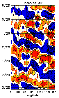
The MJO, also referred to as the 30-60 day or 40-50 day oscillation, turns out to be the main intra-annual fluctuation that explains weather variations in the tropics. The MJO affects the entire tropical troposphere but is most evident in the Indian and western Pacific Oceans. The MJO involves variations in wind, sea surface temperature (SST), cloudiness, and rainfall. Because most tropical rainfall is convective, and convective cloud tops are very cold (emitting little longwave radiation), the MJO is most obvious in the variation of outgoing longwave radiation (OLR), as measured by an infrared sensor on a satellite.

Figure 1 (from Elleman 1997) shows how the OLR anomalies in the eastern hemisphere propagate to the east at around 5 m/s. The OLR signal in the western hemisphere is weaker, and the recurrence interval for the eastward propagating OLR anomalies in the eastern hemisphere is about 30 to 60 days. How exactly the anomaly propagates from the dateline to Africa (i.e. through the western hemisphere) is not well understood. It appears that near the dateline a weak Kelvin wave propagates eastward and poleward at a speed exceeding 10 m/s.

Associated with the propagation of convective anomalies, the MJO involves variations in the global circulation. The MJO affects the intensity and break periods of the Asian and Australian monsoons and interacts with El NiƱo. Wet spells in the Australian monsoon occur about 40 days apart. Fairly weak correlations with the midlatitude rainfall patterns and jet stream characteristics have also been found (2).

In 1971 Roland Madden and Paul Julian (1) stumbled upon a 40-50 day oscillation when analysing zonal wind anomalies in the tropical Pacific. They used ten years of pressure records at Canton (at 2.8� S in the Pacific) and upper level winds at Singapore. The oscillation of surface and upper-level winds was remarkably clear in Singapore. Until the early 1980's little attention was paid to this oscillation, which became known as the Madden and Julian Oscillationnumber of MJO-related publications grew rapidly. (MJO), and some scientists questioned its global significance. Continuing reading

Speaking of surface weather and wave motion....


Nor'easter and Ice!

Brian A. Morganti of Storm Effects.com has some awesome shots from the snow storm that hit the Midwest including Chicago and merged with former Tropical Storm Olga now moving up the East Coast as a "Nor'easter" throwing a mixed bag including an ice storm in Berks County PA. (Click the Pix)


And

Steve Marshall is reporting that the same ice storm has fallen the WNEP tower in NE PA, which knocked out programming for a while.


Lastly

Bill Hark tells us that Storm Chaser Jim Reed will be on ABC Good Morning America on December 18 with Sam Champion, plugging his new book ...

by Jim Reed

Storm Chaser: A Photographer's Journey Cover


RS

Sunday, December 16, 2007

Sunday Morning Pretty!

http://static.flickr.com/119/311278983_ce3c8e6045.jpg

Well snow it did! Below are some of the totals from NWS Chicago.

The City came out of it pretty well with snow totals ranging between 4-6". South of the city? Oh well it is winter in Chicago ya' know! While this storm was bigger than the December 3rd-4th storm and we now have about 9" in total from both storms on the ground.

The streets are sloppy right now and of course not enough plows on the streets early enough but we escaped a major strike. Now its time for digging out and getting to the side streets. But this system is not done. Its next target? The North East!

Oh yeah... temps for tonight? Can you say 6 degrees?

000
NOUS43 KLOT 161617
PNSLOT

PUBLIC INFORMATION STATEMENT
NATIONAL WEATHER SERVICE CHICAGO
/ROMEOVILLE IL
800 AM CST SUN DEC 16 2007

SNOWFALL AND SNOW DEPTH REPORTS.
DATA PROVIDED BY NATIONAL WEATHER SERVICE CHICAGO AREA AND ROCKFORD
AREA SNOWFALL TEAM.

12 HR SNOWFALL 12 HR SNOWFALL TOTAL
LOCATION ENDING 6AM ENDING 6PM SNOW
TODAY YESTERDAY DEPTH AT 6AM
ILLINOIS

BATAVIA 3.0 / 1.2 / 4
BEACH PARK 2.8 / 3.0 / 8
BEECHER 6.6 / 1.5 / 8
CALUMET CITY 8.3 / 2.2 / 10
CHICAGO-NW SIDE / 1.1 /
CICERO / 0.8 /
DIXON-EAST SIDE 1.2 / 2.8 / 7
FRANKFORT 8.2 / 1.3 / 8
GRAYSLAKE 3.8 / 2.9 / 11
LA GRANGE 5.5 / 1.4 / 7
MOUNT MORRIS / 4.5 /
NAPERVILLE 2.6 / 1.2 / 6
NEW LENOX / 1.2 /
OAK LAWN / 2.3 /
OAK BROOK 2.4 / 0.9 / 5
PLAINFIELD 4SW 2.2 / 1.2 / 4
PLAINFIELD 1.8 / 1.2 / 4
RICHTON PARK 9.6 / / 10
SCHAUMBURG 3.3 / 1.2 / 6
SOUTH BELOIT 3SE / 2.1 /
WILLOWBROOK 3.8 / 1.7 / 6

NORTHWEST INDIANA

HIGHLAND 11.0 / / 11
SCHERERVILLE 8.2 / 1.1 / 8
VALPARAISO 3SE 6.0 / 1.4 / 7
WHITING 3.0 / 3.0 / 3

$$


SNOW Chicago Update

This is an amazing storm system. Currently in Chicago we have approximately 3 to 6 " of snow. Winds are at 18 gusting to 22mph. Between Lincoln park and downtown we had near blizzard conditions.

Note the impressive snow bands on the radar at left. The darker green are more narrow but also more intensive snow bands.

These are so narrow that as of 00:15 this morning. O'Hare International Airport was reporting 2" of snow and Midway was reporting 6" of snow. Currently according to spotter reports snow totals for the Chicagoland area range between 3" to 6" with snow falling steadily and expected to continue until at least 0600.


Snow fall amounts are expected to range from 5-7" in the city, 5-9” northwest of the city to a foot or more in northwest Indiana.

This system is expect to merge with former Tropical Storm Olga and turn into a Nor'easter dumping a potential mixed bag on New England.

Pretty Chicago evening though! If you don't have to work in it...or drive in it!


Camera Animation Last Hour | Today | 30 days*
* Broadband recommended

Stay dry and stay safe!
RS

Saturday, December 15, 2007

Weather Update for Chicagoland

Just got this report in from Gilbert Sebenste, Staff Meteorologist, Northern Illinois University, and I spoke to NWS Chicago just a short while ago. Heavy Snow Warning in effect for Cook, DuPage, Grundy, Will, LaSalle and Kankakee counties in Illinois.

"The low pressure system now over southern Tennessee is moving northeastmore slowly than expected.

That is because it is intensifying more quickly and becoming stronger than models and data suggested it would, even through early this afternoon.

The National Weather Service has just upgraded the snow advisory to a heavy snow warning along and southeast of a line from Evanston to West Chicago to LaSalle, for 6" and locally heavier amounts, including Cook, DuPage, Grundy, Will, LaSalle and Kankakee counties until noon tomorrow. Everyone north and west of there is under a snow advisory for 3"-6" of snow through tomorrow morning. Because the storm is moving more slowly, it has become more than obvious that the snow will last later, and should continue until it tapers to flurries Sunday morning.

Final snow accumulations are expected to range from around 6" at Hoffman Estates, to 6"-8" at Naperville, to 4"-6" at DeKalb, and 2"-5" at our far western/northwestern campuses. However, latest radar trends are making me uncomfortable...and it is entirely possible DeKalb could see 6" or more storm total snowfall by morning.

Fiurthermore...because of the more northwest track of the storm, we will see stronger winds on Sunday. In fact, I now believe we'll see wind gusts as high as 30 MPH in the morning, and 25 MPH in the afternoon from the northwest. Because the snow is rather powdery, blowing and drifting snow will be a concern, mostly in open and rural areas.

Sorry, folks...this system intensified considerably more than expected, which slowed it down and is also forcing it to track much closer to us than anticipated even last night.

As of 4 PM...3.0" has come down with this system so far in DeKalb since it started early this morning."

From NWS CHICAGO

023
WWUS43 KLOT 152148
WSWLOT

URGENT - WINTER WEATHER MESSAGE
NATIONAL WEATHER SERVICE CHICAGO/ROMEOVILLE IL
348 PM CST SAT DEC 15 2007

...WINTER STORM CONTINUES TO DEVELOP OVER THE LOWER MISSISSIPPI
VALLEY...

.LOW PRESSURE ACROSS WESTERN TENNESSEE WILL CONTINUE TO STRENGTHEN
TONIGHT AS IT LIFTS NORTHEAST INTO THE OHIO VALLEY...REACHING
NORTHWEST OHIO BY SUNDAY MORNING. A STRONG UPPER LEVEL DISTURBANCE
IS SUPPORTING THIS DEVELOPMENT AND WILL SPREAD A BAND OF HEAVY
SNOW NORTHWEST OF THE STORM TRACK...ACROSS PARTS OF CENTRAL AND
NORTHERN ILLINOIS...AND INTO NORTHERN INDIANA. LIGHT SNOW WHICH
HAS OVERSPREAD PARTS OF NORTHERN ILLINOIS AND INDIANA TODAY WILL
GRADUALLY INTENSIFY THROUGH THE EVENING HOURS AND WILL CONTINUE
THROUGH THE OVERNIGHT HOURS AS THE LOW PRESSURE SYSTEM BEGINS TO
RAPIDLY DEEPEN. SNOW WILL GRADUALLY TAPER TO LIGHT SNOW AND
FLURRIES EARLY SUNDAY MORNING. TOTAL SNOW ACCUMULATIONS IN EXCESS
OF 6 INCHES ARE POSSIBLE MAINLY SOUTHEAST OF A LINE FROM EVANSTON
TO WEST CHICAGO TO MENDOTA.

ILZ013-014-019>022-160600-
/O.UPG.KLOT.SN.Y.0009.000000T0
000Z-071216T1800Z/
/O.EXA.KLOT.HS.W.0001.000000T0000Z-071216T1800Z/
DUPAGE-COOK-LA SALLE-KENDALL-GRUNDY-WILL-
INCLUDING THE CITIES OF...CHICAGO...OTTAWA...OSWEGO...MORRIS...
JOLIET
348 PM CST SAT DEC 15 2007

...HEAVY SNOW WARNING IN EFFECT UNTIL 12 PM CST SUNDAY...

THE NATIONAL WEATHER SERVICE IN CHICAGO HAS ISSUED A HEAVY SNOW
WARNING...WHICH IS IN EFFECT UNTIL 12 PM CST SUNDAY. THE SNOW
ADVISORY IS NO LONGER IN EFFECT.

LIGHT TO MODERATE SNOW WILL GRADUALLY INTENSIFY THROUGH THE
EVENING HOURS...WITH MODERATE TO HEAVY SNOW CONTINUING THROUGH THE
OVERNIGHT HOURS. STORM TOTAL SNOW ACCUMULATION IS EXPECTED TO
RANGE FROM UP TO 6 INCHES ACROSS THE EVANSTON...WEST
CHICAGO...AND MENDOTA AREAS...TO 6 TO 9 INCHES FROM CHICAGO AND
THE SOUTHERN SUBURBS TO JOLIET TO MORRIS. THE INCREASING INTENSITY
OF THE SNOW LATE THIS AFTERNOON INTO TONIGHT WILL MAKE FOR
HAZARDOUS TRAVEL ACROSS THE AREA THIS EVENING INTO THE OVERNIGHT
HOURS AS MANY ROADS BECOME SNOW PACKED. IN ADDITION TO THE HEAVY
SNOW ACCUMULATION...NORTH WINDS WILL STRENGTHEN THROUGH THE
EVENING WITH GUSTS TO 30 MPH POSSIBLE OVERNIGHT. THIS WILL RESULT
IN AREAS OF BLOWING SNOW AND REDUCED VISIBILITIES. SNOW WILL TAPER
TO LIGHT SNOW AND FLURRIES ON SUNDAY MORNING.

A HEAVY SNOW WARNING MEANS SEVERE WINTER WEATHER CONDITIONS ARE
EXPECTED OR OCCURRING. SIGNIFICANT AMOUNTS OF SNOW ARE FORECAST
THAT WILL MAKE TRAVEL DANGEROUS. ONLY TRAVEL IN AN EMERGENCY. IF
YOU MUST TRAVEL...KEEP AN EXTRA FLASHLIGHT...FOOD...AND WATER IN
YOUR VEHICLE IN CASE OF AN EMERGENCY.

RS

EEs explain rogue waves

WoW! I have been away from blogging for just a little over three weeks and it feels more like three months.

Its been a busy time both in business and personally for me. I will have some more news about both very shortly.

But in the meantime there is weather and marine news out there.

Yes winter has arrived! Just ask anyone still without power in the mid west right now or living in Boston. Today NWS Chicago is reporting 3 to 5" of snow with lake effect. The heaviest will be during the overnight hours into Sunday. Though the temps and winds so far have not been as nasty as they can get and I am sure that is coming soon.

Talking about nasty. Here is a video of the impact of falling ice during last weeks ice storm in the mid west. Lesson Learned here? Look up when parking your car after you have been warned! This was shot by Storm Chaser and WX-Chase Moderator Chris Novy!


Killer Ice - Watch more free videos


Our featured article of today..


EEs explain rogue waves
By EE Times

R. Colin Johnson
(12/14/2007 2:28 PM EST)
URL: http://www.eetimes.com/showArticle.jhtml?articleID=204803618


Rogue waves as high as a 10-story building have been offered as an explanation for the disappearance of ships as big as an ocean liner, despite the lack of survivors to tell the tale. Recently, remote sensors set up in the oceans of the world have confirmed that single rogue waves as tall as 100 feet occur more frequently than Gaussian statistics can explain. For the first time EEs have generated rogue waves in optical fibers and have confirmed the mechanism that generates them, which they say can occur in other media too, including the ocean.

"Rogue waves are an apparently random phenomenon that is seeded by noise," said lead investigator on the project Daniel Solli, a researcher at the University of California at Los Angeles (UCLA) Henry Samueli School of Engineering and Applied Science. "We have shown that noise with the correct properties can foster the generation of one of these rogue waves."

According to Solli and Bahram Jalali, a UCLA professor of electrical engineering and the research group leader, rogue waves are analogous to the butterfly effect, a phenomenon in which, under the right initial conditions, a butterfly flapping its wings can cause a hurricane. Of course, these initial conditions are exceedingly rare, but the bottom line for the butterfly effect, according to Solli and Jalali, is that weather is very sensitive to initial conditions, as is the generation of rogue waves.

"Like the weather, these rogue waves appear to be extremely sensitive to initial conditions," said Solli. "It is still a deterministic system, but one that is very difficult to predict, because a very, very minute change in initial conditions can have a dramatic impact on the result."

Researchers studying a microstructured optical fiber near the threshold of soliton-based supercontinuum generation observed the generation of rogue waves in the optical fiber, and they began modeling the mechanism. As a result, the researchers have now characterized the proper initial conditions for generating rogue waves in any medium.

"We show that a particular set of initial conditions are responsible for generating rogue waves," said Solli. "In our experiment we discovered that we were getting some rare events that were far larger than any of the neighboring pulses, and that led us to explore this connection between this phenomenon and the oceanic phenomenon which has a very similar kind of effect."

According to the researchers, rogue waves follow "L-shaped" statistics, as opposed to the more common Gaussian statistics. This accounts for the seemingly out-of-bounds size of rogue waves: in L-shaped distributions the heights of most waves are tightly clustered together, but large outliers also occur. Now Jalali's team is working on a more detailed model for the U.S. Department of Defense, which is aiming to harness the effect for military applications.

"The next step is learning how to engineer this phenomenon, because there must be some useful applications out there, if only we could predictably engineer the outcome of this event, which occurs very rarely now," said Jalali.

Other member of Jalali's team include UCLA engineering researchers Claus Ropers and Prakash Koonath. Funding is being provided by the U.S. Department of Defense and the Defense Advanced Research Projects Agency (DARPA)

Tropical Storm Olga

Seems like Tropical Storm Olga has made her stake in weather history as reported by Arthur Rabjohn CEM, Director Steelhenge Consulting Ltd.
www.steelhenge.co.uk

CARIBBEAN: Caribbean storm death toll rises

People were swept away in Santiago when flood waters were released The toll in the Caribbean from Tropical Storm Olga, a rare December cyclone, has risen to at least 38 confirmed deaths, officials say. Hardest hit was the Dominican Republic, where at least 35 people have been killed by floods and landslides. The death toll rose again on Friday after the bodies of 12 immigrants from neighbouring Haiti were discovered in Castanuelas, a town near the border. The UN has urgently appealed for $4m (£2m) to help the many left homeless.

National Hurricane Center Reports

NHC releases 2007 seasonal summaryNOAA also releases seasonal report


On the maritime front..

The main feature story of this blog has been the rescue of the s/v Sean Seamour II, that I have focused on is about to make news again. The USCG helicopter crew that rescued the three sailors from their potential watery graves during subtropical storm Andrea this past May are about to get decorated for heroism on December 19 at USCG Air Station Elizabeth City. I will have more as soon as the new medals are placed on their salad bars.


Swimmer Drew Dazzo in the helicopter resting before being evacuated with us to Cherry Point Military hospital for injuries sustained during our rescue, AC Lt. Comdr. Nevada Smith supervising the transfer while coordinating with operations.


KAB 101

Here is a shot many of you may not have seen of the KAB 101 incident
that we reported about back on October 29th and 30th. when reported large waves struck Mexico state-owned drilling platform Usumacinta which slammed into the Kab 101 Light-Production Rig on Oct. 24, killing 21 people.


On the weather lighter side....

If global warming, greenhouse effects, jet stream changes or just plain lousy winter weather or any lousy weather for that matter does not confuse you enough? Let's just add good ole Pat Robinson to the equation. The bad weather we are having is because?


RS

Tuesday, December 4, 2007

NOAA Service Assessment on Enterprise Tornado Demonstrates Need to Build Hazard Resilient Communities

Yep been kind of busy lately so my postings have been hit and miss. I will return to normal posting shortly.

In the meantime there has been a lot of talk about building better tornado shelters and resilient communities for areas prone to tornado's.

We already have both State and Federal legislation mandating WXRadio's for all new modular buildings. But without the proper emergency planning along with shelters and or resilient buildings that can with stand some form of tornado strike. We have a half hearted law, although no warnings are worse than some warnings.

NOAA Service Assessment on Enterprise Tornado Demonstrates Need to Build Hazard Resilient Communities

November 29, 2007

Enterprise (Ala.) High School officials and students followed appropriate safety measures prior to and during the March 1 tornado outbreak which killed eight students, but the event further demonstrated the need for such facilities to have hardened safe rooms, according to a NOAA National Weather Service assessment released today. The eight students were killed as a concrete wall collapsed onto them while seeking shelter from the EF4 tornado.

“The tragic events of March 1 show that even when people have ample time and opportunity to take cover from a devastating tornado, the need for proper shelter is imperative,” said retired Navy Vice Adm. Conrad C. Lautenbacher, Ph.D., under secretary of commerce for oceans and atmosphere, and NOAA administrator. “Despite warning lead times that exceeded national standards, 19 lives were lost. Our team concluded that survival in violent tornadoes often depends on reaching an adequate hardened safe room.”

In addition to the eight student fatalities in Enterprise, an additional six people died in a mobile home park near Newton, Ga., and five others in Alabama and Georgia.

A total of 31 verified tornadoes struck 45 counties in Georgia and southern Alabama, including 13 strong or violent tornadoes (EF2 or greater on the Enhanced Fujita Scale). The deadliest was the EF4 in Enterprise.

Hardened safe rooms, lined and topped with concrete and without windows, are designed to withstand severe sustained winds and wind gusts. However, these interior safe rooms are not practical for mobile homes, which often move off their foundation during extreme winds. The team concluded that a necessary component for tornado safety in a trailer park is a hardened safe room easily accessed and shared by the community.

Risk of fatality in a mobile home is 15 to 20 times greater than for those in permanent structures. Only seven percent of U.S. residents live in mobile homes, yet this is where around 50 percent of tornado fatalities occur. However, even permanent structures are at risk in tornadoes rated EF3 or higher.

“We saw permanent structures completely removed from their foundations during the March 1 outbreak,” said Glenn Lussky, meteorologist-in-charge of the National Weather Service office in La Crosse, Wis., and team lead for the service assessment. “Hardened safe rooms are essential for tornado safety. This is perhaps the only thing that could have made a difference for the students in Enterprise.”

At the time of the deadly outbreak, school officials were criticized for not releasing the students prior to or during the outbreak. Students and staff at Enterprise High School sheltered in place for two and half hours.

“Dismissing the students could have been just as dangerous,” said Lussky. “Tornado warnings were in place the entire time, and the team agreed that shelter in place was the best response.”

Since the Enterprise tornado outbreak, the National Weather Service has moved from a county-based system of warnings to a more geographically specific storm-based warning system. The new storm-based warnings provide more precise information about the location of severe weather and the direction it is expected to move.

Testing revealed that storm-based warnings would have reduced the warning coverage area by 58.4 percent. Nevertheless, the high school and the town of Enterprise would have been under a warning for the same amount of time.

“Three successive supercell thunderstorms moved over or near Enterprise during that time,” said Lussky. “We believe the warnings and response would have been the same under storm-based warnings. This is just one of those cases where everyone did everything they could. The only thing left is the hardened safe room.”

The National Oceanic and Atmospheric Administration, an agency of the U.S. Commerce Department, is celebrating 200 years of science and service to the nation. From the establishment of the Survey of the Coast in 1807 by Thomas Jefferson to the formation of the Weather Bureau and the Commission of Fish and Fisheries in the 1870s, much of America's scientific heritage is rooted in NOAA.

NOAA is dedicated to enhancing economic security and national safety through the prediction and research of weather and climate-related events and information service delivery for transportation, and by providing environmental stewardship of our nation's coastal and marine resources. Through the emerging Global Earth Observation System of Systems (GEOSS), NOAA is working with its federal partners, more than 70 countries and the European Commission to develop a global monitoring network that is as integrated as the planet it observes, predicts and protects.

The service assessment “Tornadoes in Southern Alabama and Georgia on March 1, 2007” is available online.

WEATHER NOTE

NOAA Service Assessment - Tornado's in Alabama and Georgia, March 1, 2007


MARITIME NOTES
From CargoLaw

80-ton French F/V Monbijou, with six crew, ran into difficulties in stormy weather and took on water in the English Channel off Dungness, on the French side of the Channel, on Nov. 30. One fisherman missing and feared dead. The vessel is semi-submerged and is expected to sink shortly as continuing stormy weather is preventing immediate salvage efforts. Pollution risk considered minimal. From our Sr. Correspondent Tim Schwabedissen (Sun. Dec. 2 2007)

80-ton French F/V Monbijou, with six crew, ran into difficulties in stormy weather and took on water in the English Channel off Dungness, on the French side of the Channel, on Nov. 30. One fisherman missing and feared dead. The vessel is semi-submerged and is expected to sink shortly as continuing stormy weather is preventing immediate salvage efforts. Pollution risk considered minimal. From our Sr. Correspondent Tim Schwabedissen (Sun. Dec. 2 2007)

350-ft freight M/V RSCL Express, loaded with 4,300 tons of wood pulp, sustained damage during storm and required Coast Guard assistance on Nov. 29 approximately 150 miles southeast of Cape Cod. The vessel incurred two 15-centimeter holes in its hull approximately 10 feet above the waterline, which were caused by the anchor striking the hull during severe weather. The Coast Guard deployed 210-ft cutter Dependable, which escorted the damaged vessel to port in Boston for inspection and repair. From our Sr. Correspondent Tim Schwabedissen (Sun. Dec. 2 2007)


RS


Saturday, December 1, 2007

US Coast Guard HH-60 crew receives award for May 7th rescue

Its confirmed, on December 19th the four US Coast Guard HH-60 crew members will receive awards for the extraordinary rescue of the crew of s/v Sean Seamour II last May 7th.

The vessel caught in a sub-tropical depression subsequently named Andrea, was further battered by a rogue wave estimated above 100 feet approximately 200 miles off Cape Hatteras North Carolina.
rom left to right, swimmer Drew Dazzo who in extraordinary circumstances managed to bring us to safety, Petty Officer Scott Higgins who saved the day bringing all aboard with a frayed cable (so reminiscent of the end of Kevin Costner' film "The Guardian"), "steel nerves" Lt. j.g. Aaron Nelson who followed the fleeting sea-anchorless life-raft in winds over 70kts, and finally, Lt. Comdr. Nevada Smith who took upon himself to undertake this rescue in perilous operational conditions (for those who may have seen Kevin Costner's "The Guardian", he played the role of co-pilot Krausse). Swimmer Drew Dazzo in the helicopter resting before being evacuated with us to Cherry Point Military hospital for injuries sustained during our rescue, Lt. Comdr. Nevada Smith supervising our transfer while coordinating with operations. It is difficult to find words of appreciation, even so many months later, for the commitment of these heroes as there is no doubt failing them we would not be here to extol their dedication. Neither should we forget the C130 crew who miraculously found us among the seventy foot waves,but also the three ambulance teams, three hospital teams and the commander of Cherry Point Military Hospital who mobilized the disaster relief of the American Red Cross to help us through this crisis. Finally, a moment of silence in remembrance of the crew of s/v Flying Colors that dissapeared eighty miles off our starborard, Captain Trey Topping, Rhiannon Borisoff, Jason Franks and Christine Grinavic, likely pitchpoled by the same rogue wave amplified by their closer proximity to the Gulf Stream.


Robin Storm previous s/v Sean Seamour II posts:

Summary of Action for CG6014 for the S/V SEAN SEAMOUR II- REDUX - Plus
WebExclusive EPIRBs and the s/v Sean Seamour II - Part III

WebExclusive EPIRBs and the s/v Sean Seamour II - Part II
EPIRBs and the s/v Sean Seamour II
NHC Report on Subtropical Storm Andrea
Cheating Death On The High Seas
The s/v Sean Seamour II & The Hatteras Trench
High Sea's Update On Sean Seamour II
The Story of the Sailing Vessel Sean Seamour II

gCaptain previous s/v Sean Seamour II posts:
gCaptain Exclusive - Sailing in Severe Weather
Lessons Learned


WEATHER NOTE:

CHICAGO - S N O W!

Thanks Jean!

RS

Thursday, November 29, 2007

2007 Tornado Fatality Information

Lydia LALady Lake FLPaisley/DeLand FLGentilly LA3 SW Caulfield MOMillers Ferry ALEnterprise ALPotterville GANorth Newton GAAmericus GA6 SE Clovis NM2 E Elmwood OKHolly CO13 SSW Canadian TXHaltom City TX4 E Mulberry SCEagle Pass TXGreensburg KSHopewell KS2 SSE Macksville KS3 S Bennington KSNorthwood NDParis MOKalkaska MIWilliamston MI
All times are CST.
NOTE: Tornado related fatalities are entered once confirmed by NWS Weather Forecast Offices.
Num Date Time Location Deaths F Watch

January Killer Tornadoes: 1 Fatalities: 2
01 Jan 4 03:45 PM Lydia LA 2 F1 WT001
Three mobile homes flipped over trapping seven people...at least five brick homes received major damage.

February Killer Tornadoes: 3 Fatalities: 22
02 Feb 2 02:15 AM Lady Lake FL 8 F3 WT015
Mobile homes completely destroyed.
03 Feb 2 02:45 AM Paisley/DeLand FL 13 F3 WT015
Complete destruction of mobile homes.
04 Feb 13 03:10 AM Gentilly LA 1 F2 WT018
Several homes damaged...trailers and a hotel destroyed.

March Killer Tornadoes: 10 Fatalities: 27
05 Mar 1 06:33 AM 3 SW Caulfield MO 1 F3 WT042
Damage reported to two gas stations, four mobile homes and two frame homes.
06 Mar 1 12:30 PM Millers Ferry AL 1 F4 WT044
Manufactured home destroyed.
07 Mar 1 01:05 PM Enterprise AL 9 F4 WT046
High School severely damaged.
08 Mar 1 04:35 PM Potterville GA 1 F2 WT046
Heaviest damage southwest of Potterville.
09 Mar 1 06:30 PM North Newton GA 6 F2 WT046
Mobile homes damaged.
10 Mar 1 08:22 PM Americus GA 2 F2 WT046
Significant damage to homes and hospital.
11 Mar 23 07:54 PM 6 SE Clovis NM 2 F2 WT070
Mobile home rolled.
12 Mar 28 07:30 PM 2 E Elmwood OK 2 F2 WT082
House and shed totally destroyed.
13 Mar 28 08:00 PM Holly CO 2 F3
Large tornado destroyed mobile home.
14 Mar 28 09:50 PM 13 SSW Canadian TX 1 F3 WT082
Trailer destroyed.

April Killer Tornadoes: 3 Fatalities: 9
15 Apr 13 06:10 PM Haltom City TX 1 F1 WT135
Damage to grocery store, several homes and a church steeple.
16 Apr 15 06:37 AM 4 E Mulberry SC 1 F3 WT145
Destroyed several mobile homes.
17 Apr 24 07:01 PM Eagle Pass TX 7 F3 WT179
An elementary school destroyed and a number of mobile homes damaged.

May Killer Tornadoes: 4 Fatalities: 13
18 May 4 08:45 PM Greensburg KS 10 F5 WT227
Large tornado, much of torn damaged or destroyed.
19 May 4 09:33 PM Hopewell KS 1 F3 WT227
Two houses destroyed...sheriff dies of injuries sustained when patrol car was damaged by tornado.
20 May 4 10:35 PM 2 SSE Macksville KS 1 F3 WT227
Several homes damaged or destroyed.
21 May 5 10:30 PM 3 S Bennington KS 1 F2 WT235
Woman killed when camper was damaged by tornado.

August Killer Tornadoes: 1 Fatalities: 1
22 Aug 26 07:45 PM Northwood ND 1 F4 WT653
One male fatality in mobile home. Significant damage to town of Northwood.

October Killer Tornadoes: 3 Fatalities: 5
23 Oct 17 11:05 PM Paris MO 2 F2 WT714
Mobile home tossed 1/3rd mile into field.
24 Oct 18 07:35 PM Kalkaska MI 1 F2 WT724
Considerable property damage.
25 Oct 18 08:45 PM Williamston MI 2 F2 WT724
Modular home with two occupants flipped into a pond.

StateKiller TorFatalities
FL 2 21
KS 4 13
AL 2 10
GA 3 9
TX 3 9
MO 2 3
LA 2 3
MI 2 3
NM 1 2
OK 1 2
CO 1 2
ND 1 1
SC 1 1
TOTAL 25 79
F ScaleKiller TorFatalities
F0 0 0
F1 2 3
F2 10 20
F3 9 35
F4 3 11
F5 1 10
F? 0 0
TOTAL 25 79
CircumstanceFatalities
Mobile Home 52
Permanent Home 15
Vehicle 1
Business 10
Outside/Open 1
TOTAL 79

Top/Climatological Data/Home

Updated: Sunday Oct 21, 2007 12:32 AM

Tuesday, November 27, 2007

Survivors tell of Bangladesh cyclone horror

By Pavel Rahman

Barguna - Azahar Ali was huddled with his family, reading from the Qur'an, when the cyclone roared in from the sea. First the power went out, then screaming winds blew out the windows and ripped off the roof. Then the sea rushed in, washing them away.

"I have lost everything," the 80-year-old man said on Monday recounting how he awoke in a rice paddy to find eight relatives - including his son, daughter-in-law and three grandchildren - dead, among the thousands of people killed when the cyclone hit Bangladesh.

Details of the devastation and the stories of the survivors are now beginning to emerge as rescuers reached areas cut off because of washed-out roads and downed telephone lines.

'The monster waves swept her away from me'
At least 3 113 people were killed and more than 1 000 are still missing after Cyclone Sidr struck on Thursday, said Lieutenant Colonel Main Ullah Chowdhury, an army spokesperson. But there were fears the toll could be much higher.

On Monday, in the village of Parulkhel, residents and rescuers used bamboo poles to prod flooded fields, looking for submerged bodies. Finding a woman's corpse, others rushed in with sacks and plastic sheeting to help lift it out. Onlookers gathered, and one weeping man identified her as his mother.

"Some were identified and taken away by relatives, we buried dozens of others near where we found them," said Ali Akbar, a volunteer.

Others sifted through the remains of the village - a chaotic jumble of mud and debris from the wood, bamboo and corrugated iron homes, fallen trees and bloated animal carcasses - looking for things to salvage. A rotten stench filled the air.

In the neighbouring village of Bainsamarta, Sheikh Mubarak, 40, sat among the ruins of his hut weeping for his 12-year-old daughter.

'Just before midnight the winds came like hundreds of demons'
"As our house was washed away by walls of water, I grabbed my daughter and ran for shelter. The monster waves swept her away from me," he said. "Allah should have taken me instead."

Survivors said many of the deaths could have been prevented but people failed to heed warnings to move to higher ground.

"Nothing is going to happen. That was our first thought and we went to bed," said Dhalan Mridha, a 45-year-old farm worker from the village of Galachipa.

"Just before midnight the winds came like hundreds of demons. Our small hut was swept away like a piece of paper, and we all ran for shelter," he said.

Meanwhile, the government and relief agencies stepped up efforts to get help to the devastated areas.

Army helicopters airlifted high-protein cookies supplied by the World Food Program, said Emamul Haque, a spokesperson for the WFP office in Bangladesh's capital, Dhaka, which is coordinating international relief efforts.

International aid organisations promised initial packages of $25-million (about R169-million) during a meeting with Bangladesh agencies on Monday, Haque said.

But relief items such as tents, rice and water have been slow to reach many.

In the town of Barguna long lines of anxious people formed at the market, waiting for word that help was on the way.

"We have been waiting here for several hours, but no relief," said Uthan Ching, who left clutching a still-empty plastic bag.

Government officials defended the relief efforts and expressed confidence that authorities are up to the task.

"We have enough food and water," said Shahidul Islam, the top official in Bagerhat, a battered district near the town of Barguna. "We are going to overcome the problem."

Some, though, predicted things could become even worse.

The Bangladesh Red Crescent Society, the Islamic equivalent of the Red Cross, warned the toll could hit 10 000 once rescuers reach outlying islands.

UN Secretary-General Ban Ki-moon said in a statement that several million dollars were available from the UN's emergency response funds, depending on the need.

Many foreign governments and international groups have also pledged to help.

The United States offered $2,1-million and two US Marine Corp. transport planes have arrived in Dhaka with medical supplies, said Chowdhury, the army spokesman

An American military medical team is already in Bangladesh and two US naval ships, each carrying at least 20 helicopters, among tons of other supplies, will be made available if the Bangladesh government requests them, Secretary of State Condoleezza Rice said in a statement.

Other governments and organisations that pledged aid include the German government, which offered about $730 000, the European Union with $2,2-million, and the British government with $5,1-million. France pledged about $730 000, Japan sent $318 000 in relief supplies, Italy's Roman Catholic bishops' conference said it was donating $2,9-million, while the Philippines said it would send a medical team.

Every year, storms batter Bangladesh, a country of 150 million, often killing large numbers of people. The most deadly recent storm was a tornado that levelled 80 villages in northern Bangladesh in 1996, killing 621 people. - Sapa-AP

MARITIME NOTES
UPDATE ON THISTLE ALPHA


Thistle Alpha


Petrofac, as duty holder of the Thistle Alpha installation on behalf of Lundin Britain Limited, can confirm that following the incident this morning, 116 non essential personnel have been down manned to the nearby Murchison and Dunlin platforms.

There were originally 159 personnel on board and 43 personnel remain on the platform. All are safe and well.

A fire was reported on the platform at 08.07 on November 25th in the turbine module and was confirmed extinguished at 10:00 am.

All relevant authorities have been notified. A full investigation as to the cause of the fire is underway.

The Thistle Alpha installation is located approximately 523 km (325 miles) north north east of Aberdeen and comprises a steel jacket supporting a three deck platform, accommodation and helideck.

Maria Hamilton, a spokesperson for Lundin Petroleum, said total oil production of the Thistle Alpha platform is 5,000 barrels a day. A spokesman at Petrofac also confirmed production at the platform has stopped completely.


UPDATE ON EXPLORER FROM CARGOLAW

From The Cargo Letter - Nov. 23 2007 -Tragedy Off Antarctica

ALERT>>>2400 gt passenger M/V Explorer (built 1969) ran into trouble about 0524 GMT Nov. 23, near King George Island in the Antarctic Ocean began sinking after she hit ice, near the South Shetland Islands. About 100 passengers & 54 crew members have been evacuated and are in lifeboats. Capt. the Chief Officer remained on board the vessel until everyone was evacuated. The vessel is owned by Toronto-based GAP Adventures. M/V Explorer hit a lump of ice off King George Island this morning and the impact left the vessel with a crack in the hull the size of a fist. Weather conditions were "fairly good" for this time of year, but it would be cold. Liner about to sink. The vessel had a 30 degree list. A rescue operation is being co-ordinated by the U.S. Coast Guard in Norfolk, Virginia, with the authorities in Ushuaia, Argentina. M/V Antarctic Dream, which is in the area, has been diverted to help the rescue. GAP Adventures said 23 Britons, 17 Dutch, 10 Australians, 13 Americans & 10 Canadians were among the passengers -- remaining nationalities of the rescued tourists are Irish, Danish, Swiss, Belgian, Japanese, French, German & Chinese. M/V Explorer was the 1st custom-built expedition ship -- known as the 'Little Red Ship' to aficionado, she became the first passenger vessel to navigate the North West passage in 1984 and was involved in rescue of crew from Argentine cargo vessel off Anvers Island, Antarctica, in 1989. From our Sr. Correspondent Tim Schwabedissen and our Correspondent A. Griffiths (Fri. Nov. 23 2007 am)


RS