Friday, November 14, 2008

5 Most Dangerous U.S. Earthquake Hot Spots Beyond California

5 Most Dangerous U.S. Earthquake Hot Spots Beyond California

California isn't the only state with a serious earthquake hazard. There are several lesser-known fault zones lurking in other parts of the country that are just as dangerous, if not more dangerous, than the famed San Andreas Fault.

Some of these faults are capable of producing quakes bigger than the 1906 San Francisco quake, but because the time between major jolts is longer than in California, many people who live near these faults don't even know they are there.

Here's a closer look at five of the country's most hazardous seismic hot spots outside of California.

Map: USGS

Cascadia_tsunami10houronlylg

A computer simulation of the 1700 Cascadia earthquake tsunami after 10 hours / USGS.

THE PACIFIC NORTHWEST:

The biggest earthquakes in the country are not in California. A much greater hazard, at least in terms of sheer magnitude, exists to the north of the San Andreas Fault where the ocean crust is being forced beneath the North American continent.

Known as the Cascadia Subduction Zone, this 680-mile long stretch of colliding land mass 50 miles offshore of Oregon, Washington state and southern British Columbia is capable of generating magnitude 9 earthquakes 30 times more powerful than the worst the San Andreas can dish out.

"There are lots of other earthquakes that may happen first, but they won't be as big," said marine geologist Chris Goldfinger of Oregon State University in Corvallis.

An earthquake of this size would completely devastate the region, which includes Portland, Seattle and Vancouver. There could be thousands of deaths and unprecedented damage for a quake in this country. Major travel routes will be impassable. The shaking could last a full four minutes, which would damage or bring down structures that could have survived a shorter duration.

On top of the danger from shaking, within minutes, a tsunami would likely inundate the low-lying coastal areas. Cascadia is the same type of fault that caused the 2004 Sumatra quake and tsunami.

Fortunately, these mega quakes only come around once every few hundred years. Unfortunately, the fault may be due for another big one any day now.

The last monster quake that ruptured the entire length of the Cascadia fault occurred in 1700 and was around a magnitude 9. It created a tsunami that crossed the entire Pacific Ocean and caused damage along parts of the Japanese coast.

Scientists had calculated an average time between these major quakes of around 530 years. But Goldfinger's recent research on marine landslides caused by earthquakes over the last 12,000 years has revealed many magnitude 8 earthquakes on the southern portion of the fault in the intervening years, bringing the average down to 270 years.

"It's been 308 since the last one so the probability is much higher," Goldfinger said. In fact, is new research on landslides puts the probability of a magnitude 8 or greater quake as high as 75 percent in the next 50 years.

Making matters worse, the region isn't prepared.

"Portland has lots of unreinforced masonry buildings" that are likely to collapse in a major quake, Goldfinger said. "The retrofitting has barely begun."

"It's going to be a mess."

Newmadrid_tree NEW MADRID:

Most of the major earthquakes in the world occur at tectonic plate boundaries where land masses are colliding or pushing past one another. But in the middle of the country lurks a geological enigma near New Madrid, Missouri, that has produced some of the largest quakes on record for the United States but has yet to be fully explained by scientists.

"It's a big mystery," said geologist Eugene Schweig of the U.S. Geological Survey, who has studied the area for 23 years. "New Madrid is about as far from a plate boundary as you can get."

In 1811 and 1812, a swarm of at least three massive earthquakes struck near New Madrid, the largest of which exceeded a magnitude 8 and caused violent, damaging shaking in an area 10 times larger than did the 1906 earthquake. The quake was felt over an area of two million square miles — nearly two-thirds of the country.

During the quakes, the ground rose and fell, trees were bent, deep cracks opened up in the ground, large landslides swept down hills, huge waves washed boats out of the Mississippi River and river banks, islands and sand bars gave way.

Damage was widespread, but only a few people died thanks to the sparse population in what was then the Louisiana Territory but today is near the junction of Missouri, Illinois, Kentucky, Tennessee and Arkansas. Were another magnitude 8 earthquake to strike the region today, the toll would be much, much higher.

By analyzing deposits of sand that squirted out of the ground during past major quakes, Schweig and others estimate an average time between earthquakes of 500 years. But earthquakes are impossible to predict, and because scientists aren't even sure why major quakes occur away from plate boundaries, it is even more difficult to estimate a probability for New Madrid.

The USGS's best estimate is that there is a seven to 10 percent chance of a major earthquake between magnitude 7.5 and 8 in the next 50 years. While the probability of a major quake on any given day in the New Madrid region is far less than that of the Bay Area in California, the potential for disaster if a quake does strike is greater due to the size of the area that could be violently shaken.

Another factor is the lack of awareness and preparedness in the area. It is nearly impossible to live in the San Francisco or Los Angeles areas without knowing there is an earthquake hazard. Small quakes remind residents of that every few months or weeks. But 1812 was a long time ago, so earthquakes aren't anywhere near the top of most people's concerns in New Madrid. And most buildings in the area haven't been retrofitted.

"We have buildings that have been sitting around for 200 years," Schweig said. "It's just bricks sitting on top of bricks. There are schools and police stations built like that."

Image: 1904 photo of trees bent during the 1811/1812 New Madrid earthquakes / USGS

SALT LAKE CITY:

The forces that have built Utah's incredibly scenic landscape are also the source of a very serious and potentially deadly seismic hazard. Running along the base of the western edge of the Rocky Mountains, the 240-mile Wasatch Fault lies underneath Salt Lake City and the state's urban corridor, home to 1.6 million people.

Though the Wasatch Fault has not delivered a major quake since the Mormon settlers arrived in 1847, geologists have found evidence that it is capable of unleashing jolts as big as magnitude 7.5. It is one of the world's longest "normal" faults, where the land on one side of the fault drops down relative to the other side during an earthquake. During prehistoric times, the fault slipped as much as 10 feet during a single quake.

"That's basically the process that formed the Wasatch Range," said geologist Chris DuRoss of the Utah Geological Survey. Over the last 17 million years, the fault has experienced almost seven miles of slip, raising the mountains above the adjacent valley floor.

The fault has distinct segments that act independently, each with its own history of earthquakes. On average, every 300 to 350 years, one of the central segments, which underlie the most populated areas including Salt Lake City and Provo, has had a major earthquake. The last big one was 300 years ago.

"We're basically due for an earthquake," said DuRoss, who has studied evidence of ancient quakes in trenches dug across the different segments of the fault. "We're really getting right into that zone when we'd expect to see one."

The prognosis gets even more grim with a closer look at the segment that underlies Salt Lake City and the segment just to the north. Both average a big quake every 1,300 years. The Salt Lake City segment last ruptured just about 1,300 years ago, and the last big quake to the north was around 2,100 years ago.

The danger from a major earthquake is heightened in the Salt Lake Valley because it sits atop an ancient lake bed made of softer sediments that tend to amplify seismic waves. This is bad news for an area that has around 185,000 vulnerable buildings made of unreinforced masonry that isn't built to survive an earthquake. Most of these are homes, but some are schools and other public buildings.

Video: Utah Geological Survey


Alaskaroaddamage

The Seward highway in Alaska after the 1964 earthquake / USGS

ALASKA:

The second-largest earthquake ever recorded struck Alaska's Prince William Sound in 1964. The magnitude 9.2 quake killed 128 people, most by the resulting tsunami.

In some places, the ground was uplifted almost 38 feet, and in others it dropped more than seven feet. The tsunami reached heights of around 220 feet locally, and killed 11 people 1,650 miles away in Crescent City, California.

The "mega-thrust" quake was the product of the collision of two tectonic plates, the oceanic plate being forced beneath the continental plate. Those plates are still moving and accumulating stress that will eventually be released in another big quake. The geologic record shows gaps of 350 to 900 years between monster quakes, which would seem to put the Alaskan coast in the clear.

But there could be several smaller magnitude 8 quakes filling those gaps that aren't quite big enough to show up in the geologic record, said geologist Peter Haeussler of the U.S. Geological Survey in Anchorage. "There's enough question that we just really don't know."

And Alaska has plenty of other sources of earthquakes to contend with. The oceanic plate bends and sinks as it is pushed beneath the continent, which can cause quakes potentially up to magnitude 7. And there are plenty of active faults on dry land as well.

"The big Kahuna for Alaska is the Denali Fault," Haeussler said, which had a 30-mile-long rupture in a magnitude 7.9 earthquake in 2004.

Alaska's biggest vulnerability is its transportation infrastructure. Virtually everything and everyone that goes anywhere in the state passes through Anchorage. The airport sits on ground that could suffer liquefaction — where sediments behave like a liquid when shaken in an earthquake — that could seriously damage runways and isolate the rest of the state.


Hawaiieqdamage HAWAII:

Hawaii is well known for its volcanic hazard, but the islands are also susceptible to major earthquakes such as a magnitude 7.9 quake in 1868 that killed 77 people. Evidence of prehistoric quakes is hard to come by in Hawaii, making it especially difficult to guess when the next big one will strike.

The Hawaiian Island chain was formed by a massive plume of extra-hot magma rising through the molten mantle between Earth's crust and core. The plume forced its way through the ocean crust, creating a volcano. As the Pacific plate slowly moved over the stationary plume, new volcanic islands were formed as older ones went dormant — the Big Island is where the magma is currently breaking through.

"All our earthquakes are ultimately associated with the processes that form the volcanoes," said earthquake seismologist Cecily Wolfe at the University of Hawaii at Manoa.

Loading the ocean crust with massive volcanoes — the from ocean floor to peak, the Big Island is the tallest feature on — causes it to flex, which can produce earthquakes. Even more dangerous are the quakes caused by the expansion of the volcano as new magma pushes out from below. These jolts can be very large and cause destructive tsunamis as well. More than half of the people killed by the 1868 died in the ensuing tsunami.

With only the historical earthquake record to go by, scientists have little data to help them estimate the probability of another big quake in the future. The most recent giant quake was a magnitude 7.2 in 1975, 107 years after the previous one. Does this mean Hawaii can relax for another 70 years or so? It's impossible to say. And since 1868, there have been seven quakes of magnitude 6.2 or greater, most recently a 6.7 in 2006 that caused $250 million in damage.

Hawaii is fortunate that most of its biggest earthquakes occur on the relatively sparsely populated Big Island. And the most active part of the Big Island is the south flank, which would send a tsunami out to sea instead of toward the other islands. But big ones that do sometimes strike the west flank of the island could send a tsunami to the much more populated shores of Maui and Oahu.

"I'm sure that many people are completely unaware of the local tsunami hazard on the other islands," Wolfe said.

In the past, some of the earthquakes caused by the flexing of the crust under the weight of the islands have struck near Maui, including a magnitude 6.8 in 1938. And Hawaii has plenty of older buildings that won't survive major shaking, particularly many homes that are not bolted down to a solid foundation.

"Those buildings can literally walk off their blocks during an earthquake," Wolfe said.

WEATHER NOTE


A study of data from the National Hurricane Center shows an increase in activity.
Thursday, October 23, 2008

An analysis of data from the National Hurricane Center shows the United States has entered a period that is producing the strongest tropical systems on record. Research shows that while the intensity of hurricanes is increasing, the storms' effects are also reaching further inland.

"If the future is like the past, we probably have another ten, 15 or 20 years left in this active period," says Colorado State University atmospheric science professor Bill Gray.

Gray says the increase in activity is the result of changes in currents in the Atlantic Ocean. He believes variations in the ocean's salinity are leading to more favorable conditions for tropical development.

"There's been too much said and too many people trying to jump in and say it's human-induced global warming," Gray adds.

Other scientists disagree. The Union of Concerned Scientists' Brenda Ekwurzel acknowledges that natural factors play a role, but she says human activity has increased the temperature of the oceans, and warmer oceans can produce more tropical systems.

"We're looking at lots and lots of tropical storms," Ekwurzel says. "When one does turn into a hurricane, it's more likely to be a very, very intense storm."

Numbers from the National Hurricane Center show 207 named storms in the Atlantic since 1995. That figure represents a 68 percent increase from the previous 13 years. The data also show a 75 percent increase in hurricanes over the same period.

MARITIME NOTE

All hands on deck in simulated oil spill exercise

Photo: Darrin Zammit Lupi.

Mariners looked on curiously as the police and armed forces yesterday showed off their speedboats while ships congregated some miles off Valletta to take part in an oil recovery response exercise.

The exercise, organised by the Malta Maritime Authority and European Maritime Safety Agency, simulated the detection of a heavy oil slick off Valletta, "reported" by a fishing boat to the authority's Vessel Traffic Services (VTS).

The first call was made to the Harbour Master at 5.30 a.m. and the response was initiated through VTS calls to everyone concerned. The authority's Control Centre was fully manned by 6 a.m.

Meanwhile, vessels arrived on the scene to deploy oil-retaining booms and skimming equipment to recover the slick.

Weather conditions were favourable as the MT Santa Maria swept and skimmed the oil off the surface, in coordination with vessels from the agency's pollution response network.

When an EU member calls for help, these vessels can be deployed to help in the clean-up and response operations.

Harbour Master Capt. Richard Gabriele explained that although the exercise is a simulated one, the conditions were very real.

"The response has to be timely and coordinated and everyone has to strictly abide by the instructions," he said.

Commenting on the outcome of the exercise, Capt. Gabriele said he was confident the situation would be tackled successfully in the event of a real spill.

These recovery exercises are held every year by the authority and relevant stakeholders to sharpen the island's capabilities to deal with various types of oil pollution.

From the blog: UP Ibalon Bicol

A Sorry Maritime Safety Record Indeed In The Philippines

Few question that currently Sulpicio Lines holds the most notoriety among local shipping companies. But as I have pointed out in a previous article ["The Blame Game and Other Musing", 7/13/08] the combined WG&A is not too far behind Sulpicio, going by actual statistics.

Maybe due to the sheer number of incidents, a few of these gets left out. Or we may not be too meticulous in keeping records (the Maritime Industry Authority [MARINA] doesn't even have its ship database in order). Or far-flung incidents sometimes does not catch the attention of them national media (except when casualties are simply too many).

Few would remember that in May 1980, the Sulpicio ship MV Dona Paulina struck bottom. The same thing happened to Don Victoriano I in April 1982. Both ships were declared total losses. These two incidents happened before the infamous Dona Paz and Dona Marilyn accidents in 1987 and 1988 (see Totie Mesia's article, "RP's Maritime Disasters: A Harvest of Shame and Blame", 11/08/08). Aside from these, Sulpicio Lines' ships were also involved in minor incidents like grounding, collision, ship fire and engine breakdowns that did not involve loss of life or the total loss of the ship.

Maybe to break its string of "bad luck" (the local euphemism for loser's fate), Sulpicio Lines changed the name of their ships into Princesses. For a while it probably broke Sulpicio's jinx but on December 1997, it lost MV Philippine Princess (a former flagship) to fire and subsequent sinking followed by the sinking of the MV Princess of the Orient (another former flagship) in September 1998. Finally, "bad luck" caught up with a reigning flagship, the MV Princess of the Stars, which capsized recently.

In the same period, some other obscure incidents happened to ships not connected to Sulpicio. In the early '90s the following ships were lost:

1. MV Emerald which capsized according to MARINA records.

2. MV Ruby I of Alexis Shipping: a RO-RO that sunk just off the port of Calapan due to a holed bottom.

3. A SuperCat (a catamaran) of Aboitiz was lost due to another holed bottom between Mindoro and Batangas.

4 . MV Manila City of William Lines: a Manila-Cebu ship that caught fire while under drydock in Cebu City and was totally lost.

From the mid-'90s and 2000, the following ships were lost to fire:

1. MV Viva Antipolo 7 which caught fire in 1995 according to MARINA records. This ship was totally lost.

2. MV Gretchen which caught fire in 1996 according to MARINA records.

3. MV Kalibo Star of Maypalad Shipping which caught fire in 1997.

4. MV SuperFerry 7 of WG&A: caught fire on March 1997 just after unloading passengers in North Harbor, Manila and was lost.

5. MV Rosalia II of Lapu-lapu Shipping: a Cebu-Cataingan ferry that caught fire a few kilometers before Cataingan port, on August 1999. Three passengers were killed.

6. MV SuperFerry 6 of WG&A: caught fire on October 2000 just off Batangas and was lost. Its nearness to major sea lanes and ports assured the survival of all the passengers.

In this decade, the following steel ferries of minor shipping lines met major accidents. The details of these incidents are not complete:

1. MV Penafrancia which caught fire according to MARINA records.

2. MV Ruperto Jr. of Tamula Shipping: a Camiguin ferry which caught fire.

3. A Super Shuttle Ferry ship of Asian Marine Transport capsized.

4. MV Joy-Ruby of Atienza Shipping: sunk just off the port of Coron, Palawan.

5. MV Pulauan Ferry of George&Peter Lines: a Siquijor ferry that sunk off Cebu City.

Additionally, the following major incidents happened in the last 6 years:

1. MV Princess Camille of Shipshape Shipping: took in water while unloading passengers in Odiongan, Romblon and capsized.

2. MB Mae-Ann 5 of Lobrigo Shipping: overwhelmed by waves off Masbate City on May 12, 2005 while Typhoon Caloy was blowing. 27 people died.

3. MV Princess of the World of Sulpicio Lines: caught fire off Zamboanga del Norte coast on July 2005 and was totally burned.

4. MV Dona Ramona of Basilan Shipping: a bomb exploded while docked in Lamitan, Basilan, on August 8, 2005. Three died.

5. MV Butuan Bay of Gothong Shipping: its engine exploded just after leaving Cebu City on May 16, 2007. Three crewmen died.

6. MV Blue Water Princess of Blue Water Princess Shipping: bad weather and strong waves caused it to capsized off Bondoc Peninsula, Quezon on July 12, 2007 where 12 persons died.

7. MV Northern Samar of Bicolandia Shipping capsized in the height of a typhoon while docked in Tabaco port. Big waves moved the ship against a rock and the bottom was holed.

Additionally, an explosion and a fire happened on August 2002 while MV Tacloban Princess of Sulpicio Lines was drydocked. Two people were killed.

These 22 major incidents are separate from those mentioned in Totie Mesia's article. Proving that marine safety is indeed poor in this country.


Storm Report


Messing About In Ships Podcast


Have a super weekend!

RS

Thursday, November 13, 2008

Hurricanes, as seen from orbit

Hurricanes, as seen from orbit

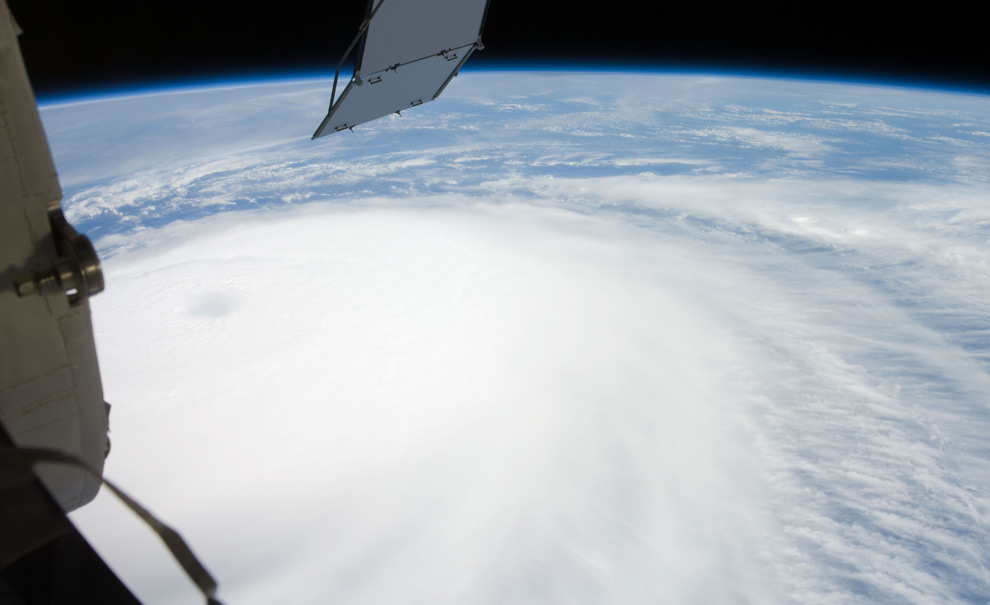
Hurricane Ike just rolled across Cuba, and soaked parts of Haiti - both regions still reeling from recent Hurricane Gustav. Ike appears to be weakening now, but is headed tward the Gulf Coast of the U.S., and may yet strengthen.

The crew aboard the International Space Station was able to take a photo of Ike from 220 miles overhead last Thursday - one in a long series of great NASA photographs of hurricanes from space. Here are some of the best, from the past several years. (25 photos total)


Additional photo's - just fantastic!


WEATHER NOTE

Hurricane Center Works with Google on Storm Surge Warning

Danger Zone
Americans may soon use Google to see whether their homes are threatened by a hurricane's storm surge, said the director of the National Hurricane Center (NHC) in March.

Storm surge, the massive wall of water carried inland by a hurricane, destroys homes in vulnerable coastal areas, and is a great threat to those who ignore evacuation orders.

NHC Director Bill Read said a planned program will pair a Google application with storm surge data that meteorologists have used for years. Together, the application and weather data will determine the flooding threat of any storm category.

"People can plug in their address and see at what level they are at risk," Read told the Reuters news service.
He said he hopes the program would be available in time for the Atlantic hurricane season, which begins June 1 and ends November 30.

Hurricane forecasters use a computerized model called SLOSH (Sea, Lake and Overland Surge from Hurricanes) that estimates storm surge heights by taking into account a hurricane's size, internal pressure, forward speed, track and wind strength.

The idea to make SLOSH models publicly available evolved from the phone calls that inundate local emergency managers and weather forecast offices every time a hurricane threatens: Read said people ask what flooding will be like at their homes.

"We're not going to know that off the top of our heads," he said. "So we can say, ‘Go to our Web site,' and it's there."

Hurricane forecasters will also offer a color-coded graphic this year on the NHC Web site, www.nhc.noaa.gov, that will indicate storm surge probabilities for threatened areas, similar to forecasts already available on wind speed probabilities. The graphic will indicate the probability of the surge reaching or exceeding 5 feet within a given number of hours, Read said.

It promises to help local emergency managers with key decisions, such as when to lock down bridges and what roads could be washed out or need to be cleared.

Students Still Iffy
Although text messaging systems have received much attention as a viable means of alerting students during a crisis, so far students have not embraced the idea, according to an Associated Press news report.

Hundreds of campuses have adopted text alerting (where students sign up for the alerts), but the enrollment rate among students and faculty is less than 40 percent, according to one provider of text alerting. According to another provider, enrollment was less than 30 percent.

Some students are concerned about giving out personal information, and others are indifferent, thinking a tragedy like last year's shootings at Virginia Tech will never happen to them. In fact, four in 10 students at Virginia Tech have still not signed up for text alerts, according to the report.

Experts said students will eventually gain confidence in text alerts, and they should be just one of many means of communicating with students and faculty.


Tower of Ash
In mid-March, a tower of ash rose hundreds of feet above the Kilauea volcano at Hawaii Volcanoes National Park, attracting residents and tourists who wanted to catch a glimpse of the first explosive eruption there in more than 80 years.

Because of a tenfold increase of sulfur dioxide emissions from the volcano, the state's health and civil defense officials were concerned about how the ash and gasses spewed from Kilauea may affect public health. Officials monitored the emissions and wind patterns just in case they moved toward the local population.

Another small explosion occurred on the morning of April 16, and civil defense officials advised nearby residents that sulfur dioxide levels "may be high enough to cause severe reactions [for] those in the sensitive groups, as well as those in the general population," the Honolulu Advertiser newspaper reported.

An evacuation center was set up at the Naalehu Community Center, but the county lifted the evacuation advisory when sulfur dioxide levels dropped.


Super Tuesday Tornadoes
What's being called the deadliest tornado outbreak in the United States in 20 years - which struck on Super Tuesday - took the lives of more than 50 people and injured hundreds.

Tornadoes and severe storms hammered the nation's midsection, sweeping through 18 counties in Tennessee, Kentucky, Mississippi and Arkansas on Feb. 5 and Feb. 6.

Tennessee was hit hardest, with 33 people dead, 189 injured and approximately 525 homes destroyed. Reports of winds up to 200 mph were reported, and damage to Union University in Jackson was estimated at $40 million.

The outbreak was the deadliest since May 31, 1985, when storms killed 76 people across Ohio and Pennsylvania.

MARITIME NOTE

Seafarer Honored for Risking Life in 24-Foot Waves to Save Drowning Man


John O. Dacuag (left) receives the Coast Guard’s Gold Lifesaving Medal from Rear Adm. Manson K. Brown.


Seafarers ([1] SIU) member John Dacuag put the extensive safety and rescue training he received from the union’s training center in Piney Point, Md., to good use in the middle of the Pacific Ocean and a typhoon when he jumped into the 24-foot seas to rescue a crewman from a sunken ship.

For his heroic efforts, Dacuag was awarded the Coast Guard’s Gold Lifesaving Medal, the Coast Guard’s highest civilian award, in a Honolulu ceremony late last month.

Dacuag was sailing aboard the U.S.-flagged cargo ship the Horizon Falcon in July 2007, when the ship received a distress call from another cargo vessel, the Hai Tong No. 7, which was about 375 miles northwest of Guam. The Horizon Falcon changed course and steamed toward the Hai Tong several hundred miles away.

But when the ship arrived the next day at the last known position of the Hai Tong, it found crew members in the water and oil slicks and debris from the sunken cargo ship. The wake of Typhoon Man-Yi was generating 24-foot seas and 40-mph winds.

On board the Horizon Falcon, Dacuag volunteered to try reaching a struggling Hai Tong crewman in the water. Climbing down a ladder on the Horizon’s portside, he attempted to reach the struggling man. According to the Coast Guard citation.

His lifesaving effort was particularly dangerous due to the severe weather, treacherous sea conditions and large amount of debris created by the passing typhoon and stricken vessel….Despite the grave risks to his own safety, Mr. Dacuag hung from the pilot’s ladder in 15–24 foot seas…he was submerged several times in water over his head.

Several times he was able to grab the man. But the winds, heavy seas and the ship’s movement broke his grasp several times. Then,

without consideration for his own life, Mr. Dacuag jumped into the extremely hazardous waters and swam to the survivor through 24-foot seas and attached the grappling hook and line to hoist the survivor on board.

Rescue efforts by the Horizon Falcon and Coast Guard search and rescue teams were able to save 13 of the 22 crew members.

At the awards ceremony, Rear Adm. Manson K. Brown said Dacuag’s

heroic daring demonstrates the absolute highest caliber of seamanship.

For more information on the SIU’s Paul Hall Center for Maritime Training and Education, where Dacuag took his rescue and training courses, click [2] here.

Marine Safety Investigation Report - Final

Man overboard fatality from the research survey ship
Geosounder, 25 August 2007
Man overboard fatality from the research survey ship Geosounder, 25 August 2007. ATSB Transport Safety Report 246 on the independent investigation into the man overboard fatality from the research survey ship Geosounder which occurred about 185 miles north-east of Cairns, Queensland on 25 August 2007.


RS

Wednesday, November 12, 2008

Scientists find evidence of tsunamis on Indian Ocean shores long before 2004

Scientists find evidence of tsunamis on Indian Ocean shores long before 2004

A quarter-million people were killed when a tsunami inundated Indian Ocean coastlines the day after Christmas in 2004. Now scientists have found evidence that the event was not a first-time occurrence.

A team working on Phra Thong, a barrier island along the hard-hit west coast of Thailand, unearthed evidence of at least three previous major tsunamis in the preceding 2,800 years, the most recent from about 550 to 700 years ago. That team, led by Kruawun Jankaew of Chulalongkorn University in Thailand, included Brian Atwater, a University of Washington affiliate professor of Earth and space sciences and a U.S. Geological Survey geologist.

A second team found similar evidence of previous tsunamis during the last 1,200 years in Aceh, a province at the northern tip of the Indonesian island of Sumatra where more than half the deaths from the 2004 tsunami occurred.

Findings from both teams are published in the Oct. 30 edition of Nature.

Sparse knowledge of the region's tsunami history contributed to the loss of life in 2004, the scientists believe. Few people living along the coasts knew to heed the natural tsunami warnings, such as the strong shaking felt in Aceh and the rapid retreat of ocean water from the shoreline that was observed in Thailand.

But on an island just off the coast of Aceh most people safely fled to higher ground in 2004 because the island's oral history includes information about a devastating tsunami in 1907.

"A region's tsunami history can serve as a long-term warning system," Atwater said.

The research will reinforce the importance of tsunami education as an essential part of early warning, said Jankaew, the lead author.


"Many people in Southeast Asia, especially in Thailand, believe, or would like to believe, that it will never happen again," Jankaew said. "This will be a big step towards mitigating the losses from future tsunami events."

The team found evidence for previous tsunamis by digging pits and auguring holes at more than 150 sites on an island about 75 miles north of Phuket, a Thai tourist resort area ravaged by the 2004 tsunami. That tsunami was generated 300 miles to the west when the seafloor was warped during a magnitude 9.2 earthquake.

At 20 sites in marshes, the researchers found layers of white sand about 4 inches thick alternating with layers of black peaty soil. Witnesses confirmed that the top sand layer, just below the surface, was laid down by the 2004 tsunami, which ran 20 to 30 feet deep across much of the island.

Radiocarbon dating of bark fragments in soil below the second sand layer led the scientists to estimate that the most recent predecessor to the 2004 tsunami probably occurred between A.D. 1300 and 1450. They also noted signs of two earlier tsunamis during the last 2,500 to 2,800 years.

There are no known written records describing an Indian Ocean tsunami between A.D. 1300 and 1450, including the accounts of noted Islamic traveler Ibn Battuta and records of the great Ming Dynasty armadas of China, both of which visited the area at different times during that period. Atwater hopes the new geologic evidence might prompt historians to check other Asian documents from that era.

"This research demonstrates that tsunami geology, both recent and past tsunamis, can help extend the tsunami catalogues far beyond historical records," Jankaew said.

The new findings also carry lessons for the northwest coast of North America, where scientists estimate that many centuries typically elapse between catastrophic tsunamis generated by the Cascadia subduction zone.

"Like Aceh, Cascadia has a history of tsunamis that are both infrequent and catastrophic, and that originate during earthquakes that provide a natural tsunami warning," Atwater said. "This history calls for sustained efforts in tsunami education."

Note: This story has been adapted from a news release issued by University of Washington

WEATHER NOTE

Reburying the dead a grim task in Ike's wake

IN THE MARSH OF CAMERON PARISH, La. (AP) — Joe Johnson craned his neck from the airboat as it circled a patch of brown marsh grass. The runaway coffin was not where it was supposed to be.

Johnson pulled up to a pile of rocks, killed the motor and hopped out. After a few minutes of scouring along the tall, reedlike grass, he flagged down two fishermen.

"Can you possibly take me along the shoreline?" Johnson asked. "I'm looking for a casket."

Beyond the usual, dismal rebuilding, Hurricane Ike left another grim task when it struck last month: Its 13-foot storm surge washed an estimated 200 caskets out of their graves, ripping through most of Cameron Parish's 47 cemeteries and others in southwest Louisiana and coastal Texas. Some coffins floated miles into the marsh.

At Hollywood Cemetery in Orange, Texas, Ike unearthed about 100 caskets. Dozens more were disgorged in hard-hit Galveston.

Officials in coastal areas have long struggled with interring the dead, as caskets buried in low-lying areas are susceptible to being belched up by floodwaters. Some areas — most notably New Orleans — house the dead in above-ground crypts to keep them from drifting away in storms.

For many of the dead forced up by Ike, it wasn't their first disturbance. About 80 percent of the caskets in southwest Louisiana displaced by Ike were rousted by Hurricane Rita just three years earlier, said Zeb Johnson, the Calcasieu Parish deputy coroner who's headed casket recovery efforts for Rita and Ike.

Of the caskets ejected by Rita in September 2005, 335 were found and reburied, he said. Eighteen were never found.

"Our mother came out for Rita, and now she came out for Ike," said Debra Dyson, a commercial fisher whose house in Cameron was destroyed by Ike.

Dyson said coffins holding her brother-in-law and cousin also were heaved out by Rita. Ike was worse — the storm thrust out caskets containing her mother, brother-in-law, cousin, niece, three uncles and two aunts.

The one containing Dyson's mother floated to the same spot it came to rest after Rita, 22 miles from the cemetery. Only this time, it didn't take nine months to find it.

"It's hard to lose your home, but the first stop you make is that cemetery just to make sure they're still there, and it's heartbreaking when they're not," said Marilyn Dyson Elizondo, Dyson's sister who lives in Dayton, Texas.

Zeb Johnson helms a team of two employees, volunteer boat pilots and state prisoners to search hundreds of miles of marsh with loaned equipment and haul coffins back to shore. The work is backbreaking, with caskets weighed down by mud in swampy areas teeming with alligators and snakes and the stench of rotting marsh grass.

"It's a job that has to be done," said Joe Johnson, a funeral director and embalmer from Lake Charles who is not related to the deputy coroner.

Joe Johnson's half-hour ride with the fishermen didn't turn up the pink casket reported to the coroner's office, like so many other tips that don't pan out. An hour later, however, he returned with another coffin found in thick grass near a canal bank.

A hole was drilled into the silver metal container to drain out marsh muck and lighten the load for the airboat. Prisoners pulling the casket from the boat tipped it again to empty out more of the fetid water.

The coffin was trucked to the city coliseum in Lake Charles, where the Federal Emergency Management Agency was providing refrigerated trucks to hold caskets until reburial arrangements could be made.

"It's a slow process," Zeb Johnson said.

The Calcasieu Parish Coroner's Office is footing most of the search and recovery bill, which hasn't been tallied. But reburying the dead is estimated to cost as much as $100,000 on top of the recovery costs, with much of the money needed for new caskets and vaults. Zeb Johnson wasn't sure who'll cover that price tag, so he wasn't sure when reburial could begin.

More than 140 coffins had been found by Wednesday, and about 20 others that didn't stray far from their burial sites were quickly reburied. Zeb Johnson doesn't expect to find all of the two dozen or more that remain missing.

"The first day we found caskets that had floated 30 miles from their cemeteries," he said. "You just have caskets floating out in the marsh. At least seven of these caskets ended up in Texas, kind of like boats, they just got out in the currents from the high waters and carried them to Texas."

The identification work in many instances is easier this time around. Bodies found after Rita were tagged with special markers, as were the silver metal coffins in which they were reburied. The coffins include a scroll with the deceased's name, where they were buried and other information.

A few families are considering reburials on higher ground. Cameron Parish's government has proposed requiring deeper burials.

Elizondo, whose family awaits word on the missing Dyson caskets, said her brother was buried in January in a deeper vault than those that housed her missing relatives. Ike didn't disturb her brother, so Elizondo wants to rebury her mother the same way, though it is more expensive.

"It's worth it. That way we have the peace of mind that mom won't be gone again," Elizondo said. "We've even offered to do the backhoe ourselves. We just don't want her coming back up again."

MARITIME NOTE

Napoli bill put at staggering £120m

THE grounding of the MSC Napoli off the Westcountry coast is the second most expensive shipping incident ever, it has emerged.

Insurers of the 62,000-tonne container ship, beached off East Devon in January 2007, have estimated the total bill for the wreck at £120 million.

It means the clean-up, salvage, vessel and cargo costs from the Napoli are second only to the Exxon Valdez – the tanker which spilt 10.8 million gallons of crude oil into the sea at Prince William Sound, Alaska, in 1989.

One of the biggest environmental disasters to occur at sea, its costs have run into hundreds of millions of pounds. News of the vast bill emerged as the Maritime and Coastguard Agency released a report into the grounding, making 11 recommendations.

Charles Hattersley, a Plymouth- based marine law expert, said the huge costs were "understandable" given the nature of the incident. But he said the scale, and cost, of the incident had not been matched by the Government's response.

"In my view, the Government should have instigated its own public inquiry into what happened," said Mr Hattersley, a partner at Ashfords solicitors. "Instead, Devon County Council has had to step up to the plate."

The cost of the Napoli grounding was revealed by the London Steam-Ship Owners' Mutual Insurance Association Limited, otherwise known as the P&I (Protection and Indemnity) Club. It is managed by London-based A Bilbrough and Company Limited.

In its annual report, chief executive Paul Hinton confirmed the Napoli's £120 million estimated bill was the "second most expensive claim ever".

He said the beaching of the vessel had avoided "a potentially very grave environmental disaster". He described the aftermath as "an enormous challenge in technical, regulatory and legal terms".

Mr Hinton added: "The salvage and removal of the wreck of the ship and her containers, as well as the disposal of cargo within the containers, has been a unique experience in a number of respects, but importantly, it is the first occasion on which a large container ship has foundered in a recoverable condition off the coast of a European state.

"Other container ships have been salvaged following fire or explosion (resulting in the loss of a relatively small proportion of their cargo) or have sunk in deep water (with the total loss of ship and cargo). "The MSC Napoli represents the first occasion when almost the totality of a ship's container cargo has been brought ashore in both sound and extensively wetted condition, for forwarding and disposal.

"This huge undertaking has also taken place under the watchful eye of one of the most robust environmental regulatory regimes in the world and every aspect of the waste cargo handling and disposal operation, involving the disposal of some 30,000 tonnes of cargo, has been scrutinised by the Environment Agency."

He said the total cost of recovering the cargo and removing the ship had escalated to some £53 million. Yesterday, the MCA's 103-page report into the incident was submitted to the Devon County Council-led inquiry into the grounding.

It concedes that lessons can be learned to improve communication between organisations and streamlining the jurisdiction between land and sea.

The report highlights 11 recommendations which include improving communications between salvagers and land-based response organisations, and educating other agencies on marine emergency procedures.

It says the next Marine National Contingency Plan should assess who is best-placed to take responsibility for protecting and cleaning the shoreline, and also how various response centres could be merged to offer more effective communication and partnerships.

But the professionalism of those involved in the operations at sea meant the risk of years of oil pollution along the coasts of Devon was averted.

The report summarises the MCA's activities from January 18 last year when the Napoli, bound for South Africa, "suffered a catastrophic hull failure" when she was 50 miles south of Cornwall's Lizard peninsula, and the 26-strong crew was rescued after taking to life-rafts.

It addresses the controversial issue of why the Napoli was towed to British waters instead of French, when its position was between the two. "The conclusion was that the least environmentally risky option was to tow the vessel to a place of refuge in UK waters," it says.

The Secretary of State's Representative for Maritime Salvage and Intervention, Robin Middleton, decided the ship was in danger of breaking up and polluting the English Channel and should be towed to Portland. But, during the operation, the weather deteriorated and the salvors and Mr Middleton decided to beach her in Lyme Bay to minimise the pollution threat.

The report says the only option was to ground the ship on shallow waters to avoid "almost certain" break-up. The Napoli had 3,664 tonnes of fuel oil and marine diesel on board.

"The spilled oil would have escaped and found its way on to many beaches, possibly on both sides of the Channel, for many years," says the report.

The report accepts that the "understandable" confusion over the legislation governing salvage had been exploited by salvagers who descended on Branscombe's beaches after 50 containers washed ashore.

RS


Tuesday, November 11, 2008

Nighttime Tornadoes Are Worst Nightmare: Twisters That Occur From Midnight To Dawn Are 2.5 Times More Likely To Kill

Nighttime Tornadoes Are Worst Nightmare: Twisters That Occur From Midnight To Dawn Are 2.5 Times More Likely To Kill

ScienceDaily (Nov. 6, 2008) A new study by Northern Illinois University scientists underscores the danger of nighttime tornadoes and suggests that warning systems that have led to overall declines in tornado death rates might not be adequate for overnight events, which occur most frequently in the nation's mid-South region.

Over the past century, the tornado death rate has declined, in large part because of sophisticated forecasting technology and warning systems. But the researchers found that the nighttime tornado death rate over the past century has not shared the same pace of decline as the rate for daytime tornadoes.

"The proportion of nocturnal fatalities and killer tornado events has increased during the last half century," said lead author Walker Ashley, an NIU meteorologist and professor of geography. "Unfortunately, this nocturnal fatality rate appears to be a major factor for the stalled decline in national tornado-fatality tallies during the past few decades."

Ashley, NIU Geography Chair Andrew Krmenec and Research Associate Rick Schwantes published their study in the October issue of the American Meteorological Society's journal, Weather and Forecasting.

The study found that from 1950 to 2005, 27 percent of tornadoes in the United States were nocturnal, yet 39 percent of tornado fatalities and 42 percent of killer tornado events occurred at night.

Ashley predicts that annual tornado fatalities might begin to rise. In 2007 alone, 80 tornado fatalities were recorded, with 59 of those fatalities occurring between sunset and sunrise. Nineteen of 26 killer tornadoes that year occurred at night. So far this year, 123 tornado fatalities already have been recorded—nearly double the annual average.

"The tornado death rate has bottomed out and is probably going to increase due to several factors," Ashley said. "Because of population growth and development patterns, including urban sprawl, tornado risk to the populace has increased in recent decades. Tornadoes are impacting larger populations that are more spread out, resulting in higher tornado death tallies."

The most dangerous window of time for a tornado, according to the study findings, is the period from midnight to sunrise. Tornadoes during this time period are 2.5 times as likely to kill as those occurring during the daytime hours.

People are more vulnerable during nighttime events because:

  • Tornadoes are difficult for the public and trained spotters to see.
  • People are more likely to be asleep.
  • People are more likely to be in structures that are more susceptible to damage, such as single-family homes and mobile or manufactured homes as opposed to schools and large office or workplace buildings. (Nearly 61 percent of tornado fatalities in mobile homes take place at night.)
  • Warning sirens are designed to mitigate hazards for people outdoors and are less effective at reaching those indoors.

"Because most people go to bed after the late evening news, they are sleeping and unaware of televised weather alerts," Ashley said. "And warning sirens give us a false sense of security. They're not designed for warning people who are already indoors. We're not seeing a forecasting problem but rather a communication breakdown. "Scientists, along with emergency managers and people living in tornado-prone areas, must work together to solve this problem," he added. "Right now, the best alert option during this overnight period is a weather radio."

A relatively small proportion of American households own weather radios, though they are widely available, cost as little as $25 and come equipped with alarms. As Ashley noted in previous studies, the nation's mid-South region is most vulnerable to nighttime tornadoes. In fact, while the "tornado alley" region of the Great Plains boasts the most frequent occurrence of tornadoes, most tornado fatalities occur in the mid-South region, which includes parts of Arkansas, Tennessee, Alabama and Mississippi.

Among the reasons for higher vulnerability: The southeast United States has the highest percentage of mobile-home stock compared with any other region east of the Continental Divide. The NIU meteorologist said 45 percent of all fatalities during tornadoes occur in mobile homes, compared to 26 percent in permanent houses.

The new study also finds that seasonal factors also come into play. The cool and spring-transition seasons from November to April have the highest nocturnal fatality rates, despite having relatively few tornado events. Daylight hours are at a minimum during these months. Also, storms that occur before the national peak in the severe storm season, which spans May and June, are more likely to catch people off guard.

"Nocturnal tornadoes are dangerous anywhere, but the danger is enhanced in the South," Ashley said. "There are more nocturnal events in the South than in the Great Plains. And the mobile-home density is much greater in the South as well. It's a combination of factors."

WEATHER NOTE

New weather satellite moves toward launch

VANDENBERG AIR FORE BASE, Calif., Nov. 5 (UPI) --

The latest polar-orbiting environmental weather satellite developed by the U.S. space agency has arrived in California for its scheduled Feb. 4 launch.

The satellite, called NOAA-N Prime, was produced by the National Aeronautics and Space Administration for the National Oceanic and Atmospheric Administration. The satellite is similar to NOAA-N that was launched in May 2005.

The satellite will be launched from Vandenberg Air Force Base by a United Launch Alliance two-stage Delta II rocket.

NOAA-N Prime is the latest satellite in the Advanced Television Infrared Observational Satellites N series built by Lockheed Martin Space Systems Co., NASA said in a statement.

NOAA-N Prime will provide a polar-orbiting platform to support environmental monitoring instruments for imaging and measuring the earth's atmosphere, its surface and cloud cover, including earth radiation, atmospheric ozone, aerosol distribution, sea surface temperature, vertical temperature and water profiles in the troposphere and stratosphere.

Officials said the satellite will also assist the Search and Rescue Satellite-Aided Tracking system.

NOAA manages the polar-orbiting operational environmental weather satellite program, while NASA's Goddard Space Flight Center in Greenbelt, Md., manages the development and launch of NOAA satellites.

MARITIME NOTE

Flares Banned over Safety Fears
'Flares light up the nightsky for up to two minutes at a time - Photo by HEATHCLIFF O’MALLEY/AFP/Getty Images' .
Coastguards in the United Kingdom have been banned from using flares in rescue missions after they were claimed to be a risk to health and safety. A spokesman for the Maritime and Coastguard Agency told Daily Mail that the devices, which are used to illuminate large areas of land and sea during night-time searches, could cause 'considerable injury'.

All 400 Coastguard rescue teams now have until the end of the year to use up their cache of flares or hand them over to the Ministry of Defence for disposal.

Volunteers have claimed the decision will put lives at risk because flares are essential for locating lost people and vessels in the dark.
One crewman said: 'This is the most stupid, ignorant thing I've heard of.

Flares light up the entire sky and aid rescue missions - something that obviously can't be done with a hand-held torch.

'This is over-zealous bosses bowing to health and safety nonsense - but they don't realise it could put people at risk.'

Tom Mullarkey, Chief Executive of the Royal Society for the Prevention of Accidents, also slammed the new ban. He called attempts by authorities to eliminate all element of danger from life as 'mindless', saying that the health and safety culture has 'gone too far'.
He insisted that individuals must retain the right to take risks so long as they do not injure others, and told safety experts that they will be accused of constructing a nanny state, adding that 'absolute safety' is an unattainable goal in any case.

A flare, also known as a fusee, can be shot into the air to heights of up to 700ft, illuminating vast areas of land or sea for up to two minutes at a time.
They have been used by the MCA since the First World War and deployed by Britain's 3,200 Coastguard volunteers in hundreds of rescue missions along the UK's 10,200 miles of coastline.

They require no legal licence to keep or fire, but the MCA - a government organisation which co-ordinates search and rescue missions - requires at least one volunteer in each crew to be certificated in their use.

But the MCA conducted a review earlier this year, which found no 'sound operational reason' for their continued use. It said 'operational pyrotechnics' were outdated and rarely deployed because of modern alternatives.

These include infra-red cameras, floodlights and night-vision goggles which are operated by the Coastguard's 12 helicopters across the UK. But there are fears among rescue teams who do not have immediate access to the helicopters and say torches do not match the illuminating power of flares.
Crews learned about the ban last week when the MCA contacted all 400 regional branches.

Last night an MCA spokesman told Daily Mail he was unaware of any incidents in which coastguard personnel had been injured using flares. But he added: 'We have suggested withdrawing the flares after a consultation with coastguard teams showed they are not being used. They are capable of causing considerable injury, and for that reason alone using safer alternatives is beneficial.'

However, another MCA Spokesman Mark Clark denied that the withdrawal was safety related. 'It's got damn all to do with health and safety,' he told Sail-World in an email, 'and all to do with the lack of use of pyros any more.

'We're reviewing the policy and if we see that there is a limited use of pyros in certain circumstances, then we'll change the guidance. There are generally one or two members of the team who are certificated to use these heavy duty and hefty pyros.'

The full text of the MCA's 'Operational Advice Note' can be read by clicking here

Flares will still be used by the RNLI and by the Coastguard's ten vessels which operate in conjunction with lifeboat crews.


Grounding of the Van Gogh

http://www.portoflarne.co.uk/filestore/images/van_gogh_6A_594_-_Rev_1.jpg

Independent investigation into the grounding of the Marshall Islands registered passenger ship Van Gogh at Devonport, Tasmania on 23 February 2008. ATSB REPORT

ATSB Transport Safety Report 252 on the independent investigation into the grounding of the Marshall Islands registered passenger ship Van Gogh at Devonport, Tasmania on 23 February 2008.

RS

Monday, November 10, 2008

Ecologists Use Oceanographic Data to Predict Future Climate Change

Ecologists Use Oceanographic Data to Predict Future Climate Change

Ecologists and oceanographers are attempting to predict the future impacts of climate change by reconstructing the past behavior of Arctic climate and ocean circulation.

In a November special issue of the journal Ecology, a group of scientists report that if current patterns of change in the Arctic and North Atlantic Oceans continue, alterations of ocean circulation could occur on a global scale, with potentially dramatic implications for the world's climate and biosphere.

"This research presents a compelling example of how climate change has altered marine ecosystems," said David Garrison, director of the National Science Foundation (NSF)'s Biological Oceanography Program, which funded the research. "It illustrates the value of basic research in understanding the underlying mechanisms and consequences of rapid climate change."

Charles Greene of Cornell University and colleagues reconstructed the patterns of climate change in the Arctic from the Paleocene epoch to the present.

Over these 65 million years, the Earth has undergone several major warming and cooling episodes, which were largely mitigated by the expansion and contraction of sea ice in the Arctic.

"When the Arctic cools and ice sheets and sea ice expand, the increased ice cover increases albedo, or reflectance of the sun's rays by the ice," says Greene, the lead author on the paper. "When more of the sun is reflected rather than absorbed, this leads to global cooling."

Likewise, when ice sheets and sea ice contract and expose the darker-colored land or ocean underneath, heat is absorbed, accelerating climate warming.

Currently, the Earth is in the midst of an interglacial period, characterized by retracted ice sheets and warmer temperatures.

In the past three decades, changes in Arctic climate and ice cover have led to several reorganizations of northern ocean circulation patterns.

Since 1989, a species of plankton native to the Pacific Ocean has been colonizing the North Atlantic Ocean, a feat that hasn't occurred in more than 800 thousand years. These plankton were carried across the Arctic Ocean by Pacific waters that made their way to the North Atlantic.

"When Arctic climate changes, waters in the Arctic can go from storing large quantities of freshwater to exporting that freshwater to the North Atlantic in large pulses, referred to as great salinity anomalies," Greene explains. "These GSAs flow southward, disrupting the ocean's circulation patterns and altering the temperature stratification observed in marine ecosystems."

In the continental shelf waters of the Northwest Atlantic, the arrival of a GSA during the early 1990s led to a major ecosystem reorganization, or regime shift. Some ocean ecosystems in the Northwest Atlantic saw major drops in salinity, increased stratification, an explosion of some marine invertebrate populations and a collapse of cod stocks.

"The changes in shelf ecosystems between the 1980s and 1990s were remarkable," says Greene. "Now we have a much better idea about the role climate had in this regime shift."

The changes observed in recent decades are only the tip of the iceberg. Previous interglacial periods have ended when the global ocean's deep circulation slowed in response to reductions in the formation of North Atlantic Deep Water, or NADW, a large, deep mass of highly saline water in the North Atlantic.

At these tipping points in the Earth's history, NADW formation was disrupted by pulses of freshwater entering the North Atlantic. The slowing of the global ocean's deep circulation results in less heat being transported to higher latitudes, accelerating ice formation and advancing the Earth into glacial conditions.

Recent modeling studies show that NADW formation will likely be resilient to freshwater pulses from the Arctic during the 21st century, according to the authors.

Continued exposure to such freshwater forcing, however, could disrupt global ocean circulation during the next century and lead to very abrupt changes in climate, similar to those that occurred at the onset of the last ice age.

"If the Earth's deep ocean circulation were to be shut down, many of the atmospheric, glacial and oceanic processes that have been stable in recent times would change, and the change would likely be abrupt," says Greene.

"While the ecosystem consequences of gradual changes in the ocean are somewhat predictable, all bets are off after such abrupt changes occur."

WEATHER NOTE

Chicago Tornado Audio From 2008...

Storm Report

Insane waves - Super Typhoon Jangmi Smashes Taiwan!


via videosift.com


MARITIME NOTE

More than 20 dead in Russian nuclear sub accident

by Vera Negdanova VLADIVOSTOK, Russia (AFP) --

http://www5b.biglobe.ne.jp/~pitroad/display/pt/pt24-25.jpg

At least 20 people were killed and 22 injured in an accident on a Russian nuclear submarine in the Sea of Japan, the navy said Sunday, the worst such incident since the 2000 Kursk disaster.

The nuclear reactor that powers the submarine was not damaged in the accident and background radiation levels in the vicinity of the accident in a Russian naval testing zone were "normal," a naval spokesman said.

"During sea trials of a nuclear-powered submarine of the Pacific Fleet the firefighting system went off unsanctioned, killing over 20 people, including servicemen and workers," said Captain Igor Dygalo, the navy's spokesman.

The submarine was undergoing sea trials and the state RIA Novosti news agency said the tests were in preparation for planned delivery of the submarine to India. This however was not confirmed by officials.

The victims included both servicemen and shipyard workers aboard the submarine for the sea trials, Dygalo said. Officials said the dead comprised six sailors and 14 civilians.

The injured were evacuated from the stricken submarine aboard an accompanying ship and were taken to a hospital on shore where they were being treated, Pacific Fleet hospital officials said.

The submarine itself returned to the port of Bolshoi Kamen, site of a large refitting shipyard near Vladivostok, where the bodies of the dead were offloaded and sent to nearby morgues, a spokesman for the shipyard said.

A source with the Pacific Fleet's hospital in Vladivostok told AFP that the injured people evacuated from the submarine aboard a destroyer were suffering various degrees of poisoning.

Other sources, who requested anonymity, said an additional 20 people with less serious poisoning were being treated aboard another ship, the Sayany, which was escorting the submarine.

The accident occurred Saturday and Dygalo said President Dmitry Medvedev had been briefed on the situation by Defence Minister Anatoly Serdyukov and had ordered a "full and meticulous" investigation.

Dygalo did not identify the submarine involved and did not explain how the accidental activation of the ship's fire extinguishing system resulted in the casualties.

However, a source in the Amur shipyard administration named the submarine as the K-152 Nerpa, a nuclear-powered submarine of the Project 971 Shchuka-B type, or Akula-class by NATO classification, the RIA Novosti news agency reported.

In October officials from the Amur shipyard reported the launch of sea trials for the 8,140-tonne Nerpa, which was put into production in 1991.

The Nerpa was due to be leased to the Indian navy, with New Delhi reportedly paying two billion dollars for the lease of two Akula-class submarines, with an option of buying them when the lease runs out.

Federal investigators meanwhile on Sunday opened a criminal probe into the accident, Interfax news agency reported.

Dygalo told AFP that the submarine itself was not damaged and there was no radiation leakage from the vessel's reactor.

"I announce with full authority that the submarine's reactor compartment is functioning normally and that background radiation aboard the submarine is normal," Dygalo said.

A total of 208 people were aboard the submarine, but of those only 81 were servicemen while the others were naval technicians and specialists.

The toll of dead and injured made the weekend accident the worst involving a Russian submarine since the 2000 Kursk disaster, when 118 crewmen died when their nuclear submarine sank after an onboard explosion in the Barents Sea.

The Kremlin was harshly criticised at home and abroad for its sluggish and secretive response to the Kursk disaster, but seemed to be moving quickly to avoid a repetition this time.

Dygalo said Medvedev had ordered the defence ministry to provide "all possible aid and support to the victims' families."

Fire suppression systems on submarines may rely on chemical liquids. It was unclear however how the accidental activation of the system on the Russian sub resulted in the deaths and injuries.

In addition to the Kursk disaster in August 2000, Russia has seen a string of accidents and mishaps with its naval submarines.

Nine sailors died aboard a K-159 submarine when it sank in the Barents Sea in August 2003 while being towed to port for decommissioning. Only one seaman survived that incident.

In 2005, a mini-submarine of the Pacific Fleet got snared underwater in a fishing net, requiring the help of a British rescue team that arrived many hours later as its oxygen supplies were dwindling.

Tanker Operator Changes Safety Procedures after Death of Crew

Thursday, November 6th, 2008

FR8 Venture was hit by huge waves killing two crewmembers working on deck in 2006.

A report by the Marine Accident Investigation Branch (MAIB) concerning the 2006 death of two sailors around Pentland Firth claims the ship’s master should have never left the safe harbor of Scapa Flow and should have delayed the sailing.

Ravindra Shrirang Bagal, 31, and Harjivan Bhikhabhal Kharva, 39, had been working on the deck of the tanker when they were hit by massive waves. The UK Coast Guard said the weather conditions were ‘horrendous’ and there were strong winds, heavy seas and huge swells. The two men were hit by massive waves and died of their injuries. A third crewmember was airlifted to the hospital where he eventually recovered.

The investigation identified safety issues, which included: The two large waves that came over the bow were not under any circumstances considered normal and waves this size should have been expected in the prevailing weather conditions. The master should have delayed the sailing.

Leaving the shelter of Scapa Flow before the foredecks were secured was the duty of the master. The crew should have been clear of the foredeck of the ship because there was little margin for error. The company should have had effective safety measures in place with an effective plan of action.

FR8 Shipmanagement PTE of Singapore reviewed all recommendations and has now set policy for all its ships. Navig8 Ship Management Pte, Ltd. is a shipping company. It controls a fleet of product tankers primarily for the oil products sector. The company trades a time-charter fleet; owns and invests in tonnage; manages vessels for third parties and for its own account; and acts as a cargo broker for oil traders; and trades in the freight derivatives market. Its products and services include ship owning, ship chartering, commercial management, technical management, cargo chartering, and risk management.

The company was founded in 2003 as FR8 Shipmanagment Pte, Ltd. and later changed its name to Navig8 Ship Management Pte, Ltd. in 2007. The company is based in Singapore, Singapore. It has offices in London and Mumbai, as well as in Singapore and the United States.

To read the MAIB Investigation report, click HERE

RS

Friday, November 7, 2008

Hurricanes Gustav and Ike Continue to Impact the Energy Infrastructure

Hurricanes Gustav and Ike Continue to Impact the Energy Infrastructure

Two months ago Hurricanes Gustav and Ike pounded the US Gulf Coast causing significant disruption to the nation’s energy infrastructure in Louisiana and Texas. Segments of our energy infrastructure impacted include:

  • drilling and exploration rigs
  • petroleum and natural gas production platforms
  • offshore-to-onshore petroleum and natural gas pipelines
  • natural gas processing stations
  • onshore petroleum and natural gas pipelines
  • petroleum refining system
  • petroleum product pipelines
  • electricity transmission system
  • electricity generation

Much has been learned about restoration from the Rita and Katrina experience of 2005. Folks working in the energy sector have performed heroically towards restoring a very complex energy system to meet demand from consumers, industry and government.

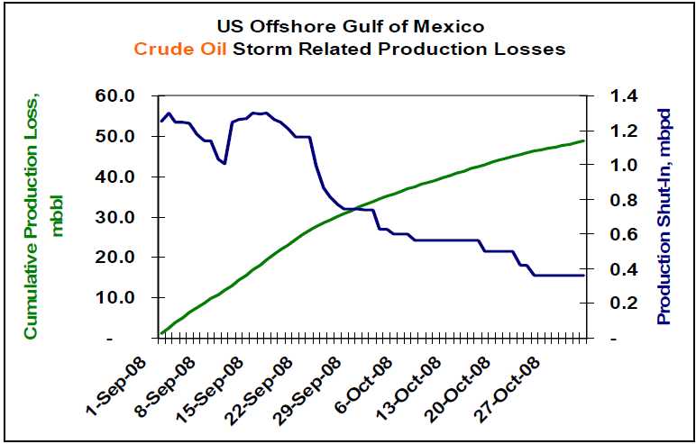
So how is the restoration effort progressing? Capstone Trading Advisors is tracking the cumulative US Offshore Gulf of Mexico production losses as reported by the US Minerals Management Service. As of 30Oct08, approximately 359.7 mbbl/day of crude oil and 2.4 Bcf/day of natural gas production continues shut-in. That equates to 27% and 33% of pre-storm production capacity, respectively. Within the last two months, cumulative production losses total 48.7 million bbls of crude oil and 253 Bcf of natural gas. See the charts below.

Lower petroleum product demand, and a corresponding reduction in refinery utilization, has cushioned the impact of this lost production. The key petroleum price drivers on a go-forward basis include 1) the depth of the global recession, 2) OPEC’s production response to lower crude oil prices, and 3) geopolitical events.

The deficit in US offshore GOM natural gas production has been made up via production from unconventional onshore sources including shale, coal bed methane and tight low-permeability formations. It is estimated that roughly 4.2 Bcf/day is being produced from these unconventional sources.

The US is expected to end the natural gas storage fill season at approximately 3.45 Tcf. The combination of storage and increased production from unconventional sources should be adequate for a normal winter season. A harsh, or early, winter could lead to significantly higher natural gas prices during the winter months. Weather is the wildcard for the natural gas market.

WEATHER NOTE

National Weather Service festival will unveil Oklahoma City Microne

NORMAN — A network of 40 weather-observing stations in Oklahoma City will be unveiled Saturday during the annual National Weather Festival in Norman.

The free festival, scheduled 9 a.m. to 1 p.m. at the National Weather Center on the University of Oklahoma research campus, also will feature hourly weather balloon launches, a storm chaser car show, a children’s activity area and a weather center open house.

The Oklahoma City Micronet dedication is scheduled for 10:15 a.m. The Micronet will have four Oklahoma Mesonet stations, along with 36 miniature weather stations installed on traffic signals throughout the city.

The Oklahoma Climatological Survey developed the Micronet in cooperation with OU and the city of Oklahoma City. The survey also runs the Mesonet, the system of more than 110 weather stations throughout the state.

Mesonet and Micronet stations record temperatures, wind speed and precipitation.

Past National Weather Festivals have attracted visitors from all over Oklahoma and other states.

The car show features vehicles ranging from weathered clunkers driven by amateur chasers to newer television-station vehicles with state-of-the-art technology.

Visitors also can see forecasters at work while touring the National Weather Center, said Keli Tarp, a spokeswoman for the National Oceanic and Atmospheric Administration’s Weather Partners.

Nearly Half of U.S. States Fail on Emergency Plan Communication, New Study Shows

ScienceDaily (Oct. 27, 2008)
Seven years after Sept. 11, and in the wake of many major natural disasters such as forest fires, hurricanes and flooding, nearly half of U.S. states either have no state-level emergency plan or do not provide it readily to the public, reveals a new study by George Mason University Communication Professor Carl Botan.

Despite federal laws that require a state emergency operations plan (EOP) as a prerequisite to some federal funding, 22 states were unable to provide Botan with an EOP, withheld the plan on security grounds or made it difficult for even trained researchers to gain access. Residents of these states, Botan says, may question their state's preparedness because they are unable to find out how the highest authorities in their state coordinate responses to major disasters or how to have a say in those plans.

"While most Americans will have access to some important state-level information during emergencies, many may not. When minutes may make the difference between life and death in an emergency situation, the population should not have to waste precious time looking for answers or who to turn to," says Botan.

The study, "Using Sense-Making and Co-orientation to Rank Strategic Public Communication in State Emergency Operations Plans," graded and ranked the state emergency operations plans of the 50 U.S. states and the District of Columbia on their communication components.

Botan analyzed the accessible state EOPs for three criteria: if the plans had a two-way communication component, if they addressed the communication needs of vulnerable populations and if they treated public communication as important enough to specifically address it in the plan.

He found that the 29 jurisdictions that do have plans available make provisions for public communication-including news releases and public broadcasts, but only 16 of them make explicit or implicit provisions for two-way public communication such as community forums and focus groups. Botan feels that two-way public communication is essential in the plans, for that will allow the state to understand what its residents feel they need in emergency situations.

Of the 29 plans obtained, only two-Washington, D.C. [which is treated as a state-level entity for this purpose] and New Mexico-received a perfect score of eight for communication.

In addition, while 16 states mentioned vulnerable publics, only 13 of these discussed specific communication strategies for these vulnerable publics in their plans. For example, California mentions specific strategies such as dispatching special teams targeting vulnerable populations like the aged and the disabled, while Arizona simply mentions that emergency managers must pay attention to "special needs" people like residents of nursing homes and the hearing impaired, but does not outline specific strategies to communicate with them.

As of 1988, all states are required under the Stafford Disaster Relief and Emergency Assistance Act to have a written EOP in order to qualify for some federal funding. "Billions of tax dollars have been spent on homeland security in the last half-decade," Botan says. "It's very important that these plans are available to the public. Otherwise residents can't be confident their needs have been thought of, and aren't sure who they can count on."

The study, co-authored by George Mason University alumni Paul Penchalapadu, is to be presented at the National Communication Association annual conference in San Diego on Saturday, Nov. 22.


MARITIME NOTE

Coast Guard rescue swimmer injured during sinking sailboat rescue

PORTSMOUTH, Va. - Coast Guard rescue crews from six different units, including three Cutters and three Air Stations, responded to a sinking sailboat with three people onboard approximately 102 miles southeast of Atlantic City N.J., Wednesday.

Rescued were Kevin Hogan, a 52-year-old and Teresa Gravie, age unknown. Phil Rubright, a 65-year-old Detroit resident was recovered but pronounced deceased by the Atlantic County Medical Examiner Office in Atlantic City.

The Coast Guard began its search after watch standers at the Rescue Coordination Center in Portsmouth received an Emergency Position Indicating Radio Beacon (EPIRB) alert and determined it was aboard the 44-foot sailing vessel FREEFALL.

After obtaining this information Coast Guard rescue crews, aboard a C-130J and MH-60 Jayhawk helicopter were launched from Coast Guard Air Station Elizabeth City, N.C.

The Elizabeth City rescue crews arrived on scene but were unable to hoist the three passengers from the FREEFALL due to the extreme weather conditions consisting of rain and 40-50 knot winds and 40-50 foot seas. The rescue crew determined that in order to conduct a safe hoist the passengers and the rescue swimmer had to enter the water. The rescue swimmer and Mr. Rubright entered the water to attempt the hoist but the rescue basket and hoist cable were damaged by a large wave.

The helicopter crew deployed a life raft and Mr. Rubright was placed in it. Reportedly another large wave hit and injured the rescue swimmer and tossed Mr. Rubright from the life raft. The injured rescue swimmer was unable to recover Mr. Rubright.

The helicopter crew employed the Emergency Recovery Device (ERD) to recover the rescue swimmer. This manual recovery device is only used during the most extreme circumstances and the person being hoisted must be trained and wear a rescue strop.

Without the means to recover Mr. Rubright the helicopter crew called for assistance and departed for Atlantic City to seek treatment for the injured rescue swimmer.

The Coast Guard then launched two MH-65 Dolphin rescue helicopter crews from Air Station Atlantic City along with a HU-25 Falcon jet and a MH-60 Jayhawk helicopter crews from Air Station Cape Cod, Mass. The 270-foot Coast Guard Cutters Northland and Seneca, along with the 87-foot Coast Guard Cutter Mako were also dispatched to the scene.

The Atlantic City helicopter crews were able to relocate the stricken vessels crew and relay the position to the incoming Cape Cod rescue crews.

Upon arriving on scene the Cape Cod helicopter crew recovered Mr. Rubright from the water and flew him to Atlantic City where he was pronounced deceased by the Atlantic County Medical Examiner.

A second MH-60 Jayhawk rescue helicopter crew from Elizabeth City was dispatched to the scene and hoisted Hogan and Gravie from the sailboat and flew them to Air Station Atlantic City where they were turned over to local EMS crews and taken to a AtlatiCare Regional Medical Center in Atlantic City for treatment.

Both Hogan and Gravie suffered from mild hypothermia and are in good condition.

This case is under investigation by the Coast Guard.

Salvors Rescue Grounded Containership with Hazardous Cargo on Board

NETHERLANDS-based towage and salvage specialist Multraship and Belgian salvage operator URS Salvage & Maritime Contracting have refloated the 39,900 gt, Singapore-flag containership Kota Lagu, which grounded in the River Scheldt with hazardous cargo on board on October 25.

The 2006-built vessel grounded after suffering rudder failure near Ossenisse on the River Scheldt, between Hansweert and Antwerp, during ebb tide. Working under a Lloyd’s Open Form agreement, Multraship and URS immediately mobilised an experienced salvage team and six tugs. The salvors tried to refloat the vessel on the same tide, but the water level had fallen too far and the operation had to wait for the next tide, at around midnight.

Because the vessel had hazardous cargo on board, local authorities declared a ‘High Alert’ situation, and the salvors accordingly made provision for a potential major incident by mobilising further tugs, salvage professionals, booms, pumps, and lighters for bunker discharge. In the event, eight tugs were able to refloat the vessel on the next tide and subsequently towed it to the Scheldepoort yard at Flushing, where it was redelivered to its owners.

Leendert Muller, managing director of Multraship, says, “This was another incident which served to illustrate the essential nature of the professional salvage industry, and the importance of having immediate access to its resources and expertise. Working closely with the local authorities, we were able to avert a potentially catastrophic outcome, given the presence on board the vessel of hazardous cargo.”

Peter Vierstraete, general manager of URS, adds, “The fact that we were able to refloat the vessel on this occasion without major incident should not disguise the continuing need to ensure that the resources are available, and in position, to deal with such emergencies.


Messing About In Ships Podcast


Have a wonderful weekend...

RS