Friday, September 14, 2007

Special Maritime Safety Edition - gCaptain + Humberto, Ingrid and Nari!

Special Maritime Safety Edition

Safety Officer

This edition of the gCaptain Newsletter is dedicated to mariners presently at sea. We have put together stories, articles and links to help return your guys to their families with nothing more than a slight limp from bulging wallets and a strained face from the smiles on their faces.

Your job... read the articles then forward this newsletter to 5 of your friends . Trust us, their families will thank you!

Awe Nuts! By the Artful Blogger

Another day of reviewing incident reports. It never ceases to amaze me, how many of these tragedies could have been avoided. Yes, I judge. It's my job. OK, it's real easy to play the critic; to stand outside of the barrel, pointing inside, and say, "Gee, that's messed up." It's a lot safer than being "in" the barrel.

Here's a quick list of incidents. See if you can figure out what they all have in common; then, we'll talk:

  • I Rigid Hull Inflatable Boat (RHIB) was launched. It entered the water along with a section the boat davit.
  • A twenty pound roller fell fifty feet from an oil derrick.
  • A tanker grounded in Long Beach after suffering a steering failure.
  • Earlier this summer a large US Flag passenger / vehicle ferry experienced a catastrophic failure of its main electrical switchboard.
  • Recently a Great Lakes bulk cargo vessel suffered a boiler tube rupture resulting in a boiler casing failure which injured two crewmembers. The tube failure was not unique and the boiler casing should have contained and channeled the steam out the stack.

Click Here for the Artful Blogger's answer

More from The Artful Blogger:

Bravo on My Watch

One Hand - EPIRB Failure

EPIRB Floating at SeaWhat is the single most import piece of electronics aboard your ship? For me it's the EPIRB. If all else fails the EPIRB should get my position to the RCC .

We only reserve the term "One Hand" for our most important stories
that require Your Help and this is one of the most important articles
written in gCaptain's short history. The following are the details from Chief Engineer Robert Stormer:

"We wish to alert our readers to the story of the sinking of the f/v Papa George.

Seems we have another boat that had a possible malfunction of its EPIRB. Only this time there were two deaths involved. We cannot stress how these types of incidents impact everyone in the maritime community. So we are putting out a maritime wide alert and request for information. " Read More for the Details...

The Case Of The Killer Catch - Special Edition MAC Report

Pesbo BSC25m Lifeboat Drawing

Bob Couttie sent us an email yesterday announcing a Special Edition of his Maritime Accident Casebook (MAC). Lifeboat Releasing GearWhy did he release this issue early? รข€¦.because it's a look at lifeboat safety and more specifically the details of a recent incident that claimed the life of three maritime officers, a bosun and cadet.

Read the full post the head over to Bob's site and subscribe to his Maritime Accident Podcast.

More from MAC:

What is the most dangerous place aboard ship?.

A Call For Help

At gCaptain we are committed to bringing important topics to the eyes of the shipping industry. Robin Stormer is a Chief Engineer but has a passion for Severe Weather. Bob Couttie is a writer with a passion for maritime safety. The Artful Blogger is an engineer with a passion for writing. What is your passion?

We are looking for mariners and industry personnel who have a passion for (fill in the blank). If you work in the maritime industry, have a specialty or passion and would like to write about then hit reply to this email and attach your article or story.

Entries are accepted regardless of writing ability, skill level or position. gCaptain editors will correct or investigate any errors and publish your story to our blog.

Not interested in writing? Find an article on the web and email it to us or submit it directly to our News Discoverer.

Many Thanks

This Newsletter was made possible with help of the Maritime Executive Newsletter, Robin Storm, Maritime Accident Casebook, Fred Fry's Maritime Monday and all our fellow maritime bloggers.


CLICK HERE for more information on our partners.

In this issue:

Incident Reports:

Firefighting Safety:

From The Archives :

Viral Video :

Photo Essays :

Discover Safety News:

Forum Posts:

Discoverer Bookmarklet

Have you found an important safety alert or article on the web? Visit our Discoverer Bookmarklet page to find out how to submit stories to us fast and easy.

Weekly Quiz

Who sent the first wireless distress call?

Pass it on

Safety is paramount. Please foward this to 5 friends and your safety coordinator OR let us forward up to five spam free copies.

iPhone Contest

We are giving away an iPhone to the gCaptain reader who submits the most voted on story to our Maritime News Discoverer. For details CLICK HERE.

Maritime Industy Search Engine

Shop gCaptain

Visit our store for some great Anchor Logo t-shirts, stickers and more.

Supporters

YOUR AD HERE

Vote For This Newsletter


Subscribe
to our feed

Advertise with gCaptain

Do you know we have logged over 150,000 page views since launching gCaptain in May 2007? Download our Rate Sheet to find out about unique advertising oppertunities for the Maritime Industry.


Weather Story
Hurricane Humberto


Fast-forming Hurricane Humberto hit the Texas-Louisiana border area killing at least one person, shut down three refineries and cut power to more than 100,000 customers. It had been expected to hit land as a tropical storm, but suddenly strengthened into an 137-kph hurricane before coming ashore.

From FEMA

Tropical Depression Humberto will continue to weaken as it tracks northeast and then east today. Its main impact will be the rainfall (1-2 inches) and flooding as the moisture interacts with the stationary front over the Carolinas. Check the Hydrometeorological Prediction Center ( http://www.hpc.ncep.noaa.gov/discussions/pmdspd.html ) for the latest information Flood watches are in effect for parts of central and northern Mississippi. Flood warnings are in effect for portions of the Vermilion River in Louisiana. These rains will at least allow for some relief across drought stricken areas of the southeast.

Here's a story of note
:

"The Coast Guard would like to strongly remind the maritime community and boating public to track the storm’s progress and take early action to protect themselves and their vessels. Extremely high seas, heavy rains and damaging winds that accompany tropical storms and hurricanes present serious dangers to mariners. Rescue and assistance by the Coast Guard and other agencies may be severely degraded or unavailable immediately before, during and after a devastating storm."

Coast Guard rescues man stranded by Humberto


Tropical Storm Ingrid

[full basin map of tropical cyclone activity]At 5:00 am EDT the center of Tropical Storm Ingrid was located near latitude 15.1 north, longitude 49.2 west or about 805 miles east of the Lesser Antilles.

Ingrid is moving toward the west-northwest near 7 mph and this motion is expected to continue for the next 24 hours.

Maximum sustained winds are near 40 mph with higher gusts. Some slight strengthening is forecast during the next 24 hours.

Tropical storm force winds extend ward up to 50 miles from the center. Based on the current warning the system will be approximately 400 miles northeast of San Juan, Puerto Rico at 2:00 am EDT on Wednesday 19 September.


Typhoon NARI

The image “https://metocph.nmci.navy.mil/jtwc/satshots/12W_140530sams.jpg” cannot be displayed, because it contains errors.

Bushman has the track on NARI

MARITIME NOTES Thanks Dennis!

Hearing on cruise ship security

On September 19, the Subcommittee on Coast Guard and Maritime Transportation will conduct an oversight hearing on Cruise Ship Security Practices and Procedures. (9/12/07).

Singapore – piracy and armed robbery off Somalia

The Singapore Maritime and Port Authority (MPA) issued a circular reminding owners, operators, and masters of the continuing threat of piracy and armed robbery against ships in waters off the coast of Somalia. Shipping Circular No. 16 of 2006 (9/12/07).

UK – report on shipping container collapse

The UK Marine Accident Investigation Branch (MAIB) issued the report of its investigation of the collapse of shipping containers on a container ship in the Baltic Sea on 26 February 2007. The investigation revealed what appears to be a systemic problem with the rapid loading of containers, allowing minimal time for the ship’s officers to determine whether the loading is being done in accordance with the load plan and to calculate the effect of the loading on ship stability, among other factors. The report recommends development of a best practice safety code and other industry-wide changes. Report No. 21/2007 (9/13/07).

U.S. Notice to Mariners Number 33-2007 (2007-08-18)

Keep Posted!

RS
Thursday, September 13, 2007

Remote Operated Vehicles

Let's take a look at some technology that is critical to both the oceanography and salvage fields. They are known as Remote Operated Vehicles (ROVs).

Remotely operated underwater vehicles (ROVs) are unoccupied, highly maneuverable underwater robots operated by a person aboard a surface vessel.

They are linked to the ship by a group of cables that carry electrical signals back and forth between the operator and the vehicle. Most are equipped with at least a video camera and lights. Additional equipment is commonly added to expand the vehicle’s capabilities. These may include a still camera, a manipulator or cutting arm, water samplers, and instruments that measure water clarity, light penetration, and temperature. First developed for industrial purposes, such as internal and external inspections of pipelines and the structural testing of offshore platforms, ROVs are now used for many applications, many of them scientific. They have proven extremely valuable in ocean exploration, and are also used for educational programs at aquaria and to link to scientific expeditions live via the internet.

Deployment and Maneuverability

ROVs range in size from that of a bread box to a small truck. Deployment and recovery operations range from simply dropping the ROV over the side of a small boat to complex deck operations involving large winches for lifting and A-frames to swing the ROV back onto the deck. Some even have “garages” that are lowered to the bottom. The cabled ROV then leaves the garage to explore, returning when the mission is completed. In most cases, however, ROV operations are simpler and safer to conduct than any type of occupied-submersible or diving operation.

<span class=

Lights and video cameras equip ROVs, enabling the operator to record imagery below the ocean surface. The S2 Phantom ROV, shown here, can move horizontally, vertically and laterally. Click image for larger view.


The disadvantages of using an ROV include the fact that the human presence is lost, making visual surveys and evaluations more difficult, and the lack of freedom from the surface due to the ROV’s cabled connection to the ship. The S2 Phantom ROV highlighted here has been rated to an operating depth of 2,400 ft. The vehicle has four thrusters that each provide one-half horsepower of thrust for horizontal, lateral, or vertical movement. Two of the thrusters are mounted horizontally. They allow the vehicle to move forward and backward, and to turn left and right. The other two thrusters are mounted at an angle, slanted in opposite directions. They provide vertical thrust (when both spin in the same direction) and lateral thrust (when they spin in opposing directions, one pushing water up, the other pushing it down).

An ROV operator controls the vehicle from a system on board the ship. Using a joystick, a camera control, and a video monitor, the operator moves the vehicle and the camera to desired locations; the operator’s eyes essentially “become” the camera lens. The vehicle’s depth, heading, and geographic position (latitude and longitude) are also recorded.

Multiple Uses

ROVs are often kept aboard vessels mounting submersible operations for several reasons; the first is safety. In the event that a submersible becomes entangled or otherwise incapacitated, an ROV can investigate the scene to help the operators decide how to respond. If appropriate, cutter blades can be attached to the manipulator arm and used to free the sub. If a sub loses power and cannot surface, the ROV’s manipulator arm can grab onto the sub. The deck crew can then bring the sub to the surface.

ROVs also support exploration and science objectives. When the submersible cannot be used because of weather or maintenance problems, the ROV often can take its place. It can also be used to investigate questionable dive sites before a sub is deployed, limiting risk to the expensive subs and their pilots.

Lets take a look at a salavge application.

The Wreck of the Bow Mariner

Information about the tragic explosion and sinking of the Bow Mariner

Feb. 28, 2004

click on photos to see the full size image

photos courtesy of NOAA

click to enlarge
Bow Mariner's sister ship-Bow Petros
photo courtesy of Dennis Shum

On Saturday, February 28, 2004 the Bow Mariner, a 570 foot tanker was southbound off the coast of Virginia when it caught fire, exploded and sank. The tanker was carrying 3.5 million gallons of ethanol, 48,000 gallons of stored diesel fuel and 193,000 gallons of fuel oil. The vessel was roughly 50 miles east of Chincoteague, Virginia in about 240 feet of water when it sank. Water temperature was around 44 degrees at the time.

A scallop boat Captain described the disaster:

"I was 30 miles north of the Bow Mariner when she blew. I heard the MayDay(s) and about 20 seconds later all the other trawler skippers say "Look at that! The flames are several hundred feet." then the explosion and the flames were several thousand feet." Another scalloper described it this way..."The sun was setting in the west and from the flames on the Bow Mariner it looked like another sun was rising in the east."

Six survivors and 3 bodies were initially recovered from the water. The Coast Guard suspended the search for the 18 missing crewmembers from the Bow Mariner at 1 p.m. March 1, 2004. The search had involved more than 80 Coast Guardsmen, including crews from Station Chincoteague, Va., Air Station Atlantic City, N.J., and Elizabeth City, N.C., the 87-foot patrol boats Shearwater and Albacore from Hampton Roads, Va., and six command centers. Crews conducted 30 separate search patterns expending more than 3,500 man hours and covering an area of approximately 70 square miles.

Reports from the various government agencies as well as local witnesses described the ethanol to be dissipated and the oil slick to be about 9 miles in length off the coast within days. Favorable weather helped disburse the oil and carry it offshore. The Marine Spill Response Corporation (MSRC) oil recovery vessel Virginia Responder was dispatched on the scene and recovered approximately 25,000 gallons of an oily water mix about 18 miles from where the vessel sank.

The USCG cooperated with NOAA on the disaster and the NOAA Ship Rude was brought in to survey the wreck with side scan sonar technology. In addition SMIT Salvage was contracted to explore the wreck further and possibly extract chemicals from the vessel.


The ROV (ROLS)
FRAMO Remote Offloading System

Salvage work began in the case of the tanker BOW MARINER, on Feb.28 after experiencing several explosions and fire. Six crewmen survived, 3 bodies have been recovered and 18 are missing.

The salvage team deployed a Remotely Operated Vehicle (ROV) and specialized divers to locate the missing crewmembers of this tragic accident. The salvor's second task was to remove the bunker oil from the tanker that lies in the Atlantic Ocean at a depth of approximately 264 feet.

Heavy weather has hampered ROV operations to locate the missing seamen as well as survey operations to determine whether recoverable quantities of its cargo of ethanol or bunker fuel remain in the vessel. The salvage team used a unique pollution recovery system, the FRAMO Remote offloading System (ROLS) that has been designed to remove oil and chemicals from vessels lying on the seabed in very deep water without the assistance of divers.

This ROV reverse screws itself in the side of the ship board tanks and drills a 3/8" dia hole, inserts its impeller into the ships tanks and then begins to pump the bunkers to a waiting ship or barge on the surface.

Next we will take a look at other specific ROVs and there missions.

Maritime Notes:

Other marine casualities due to storms. from Cargolaw

90-m 3,183-gt Cyrpus-flagged cargo M/V Storoe (IMO 9321530) lost several hundred logs in the North Sea off Juist in rough seas on Sept. 9. Warnings for navigational hazards have been issued. From our Sr. Correspondent Tim Schwabedissen (Wed. Sept. 12 2007)

Spanish F/V Nueva Pepita Aurora, with 16 men aboard, sank amidst strong winds in the waters off the town of Tarifa, southern coast of Spain, on Sept. 5. Three people reported dead and five others missing. (Thurs. Sept. 6 2007).

Weather Story: UPDATE 13.08.2007


HURRICANE HUMBERTO woke up the Southern Texas Coast!

Sept. 13 (Bloomberg) -- Humberto, the third hurricane of the Atlantic season, slammed into eastern Texas early today with winds of 85 miles (135 kilometers) an hour.

Humberto hit the Texas coast east of High Island at about 2 a.m. local time, the U.S. National Hurricane Center said on its Web site. At 7 a.m., Humberto was about 25 miles west-northwest of Lake Charles, Louisiana, on the Texas-Louisiana state line, heading northeast at 12 mph. Sustained winds weakened to 80 mph.

The system grew to a hurricane less than 24 hours after developing into a tropical depression. It is expected to weaken to a tropical storm over land.

Forecasters are also monitoring a system about 930 miles east of the Lesser Antilles with sustained winds of about 35 mph. The depression in the Atlantic may develop into a tropical storm today, the center said in a separate advisory.

Humberto prompted the center to issue a hurricane warning from east of High Island to Cameron, Louisiana. The area includes three major oil refineries around Port Arthur and Beaumont in Texas. Texas Governor Rick Perry put National Guard forces, helicopters and vehicles on standby for search-and-rescue operations as Humberto intensified from a depression to a storm. A state of emergency was declared yesterday in Louisiana.

``Some areas of our state remain saturated by summer floods, and many communities in this storm's projected path are at high risk of dangerous flash flooding,'' Perry said on his Web site. ``We will work with local officials to provide the state resources necessary to ensure the safety of all Texas residents as this storm moves over.''

Plants in Area

The warning area for Humberto encompasses a Total SA plant producing 240,000 barrels of oil a day, Valero Energy Corp.'s 325,000 barrel-a-day facility and the 285,000 barrel-a-day Motiva Enterprises LLC plant. Motiva is a refining joint venture between Royal Dutch Shell Plc and Saudi Aramco.

Humberto's sustained winds of 85 mph made the system a Category 1 hurricane, the weakest on the five-step Saffir-Simpson scale. Hurricane-force winds extended 15 miles from the eye of the storm, and tropical storm-force winds of at least 39 mph reached out 60 miles.

The system was forecast to dump as much as 15 inches (38 centimeters) of rain on a track from southwestern to northeastern Louisiana, southeastern Arkansas and into central and northern Mississippi.

``Isolated tornadoes are possible in southeastern Texas and southwestern Louisiana through this afternoon,'' the hurricane center said.

To contact the reporter on this story: Alex Morales in London at amorales2@bloomberg.net .

Last Updated: September 13, 2007 08:22 EDT

RS


Wednesday, September 12, 2007

Annual Call for SKYWARN Footage


This was a decent severe weather year for most of us --with possibly more nasty weather yet to come. Many of you are now working on/thinking about your highlight reels. I figured now would be a good time to announce my annual "call for SKYWARN video" a little early while you are spending time with the *raw* footage. My free classes would not be possible without the generous contributions of footage from storm chasers, spotters, EM, ham radio, and the media. Each year I search for fresh footage of weather-related phenomena to help get people more excited about attending the training / re-training.

Further, I'm on the look out for never-been-seen footage of unique events such as lightning strikes, accidents, flood rescues (there have been a lot of these lately), tornadoes causing damage, and giant hail. I'm talking about eye-opening video which helps drive the safety points home and maintain interest in a dark crowded room.
Most chaser highlight videos contain a lot of tornado footage. That's good for entertainment and research but not necessarily the best material for spotter training since the majority of what spotters really see (and get confused about) is non-tornadic. Therefore the footage you may be thinking of discarding from your highlight reel often turns out to be the best material for training. So what am I looking for? Well put yourself in the position of a new spotter.

This might be a 14 year old girl or a 50 year man old who's suddenly become interested in severe
weather after a recent close call with a tornado. These are folks who likely have little or no exposure to severe weather training outside of what they've seen on TWC/TLC/NGC. What kinds of things do you think these folks might need to know to operate safely around storms and make meaningful and accurate reports? Now consider the people who have attended several (perhaps dozens) of SKYWARN classes. You know, the folks snoring in the back of the room! What kind of material do you have which might help teach these "old dogs" some new tricks? Ask yourself this. Have you seen spotters make the same bad calls or dumb mistakes over and over and you've said to yourself "what's the matter with these morons?" Most people aren't morons they've just haven't received adequate training and reinforcement. It's the "old dogs", whom many new spotters look up to for training and reassurance, that pass on valuable experience as well as misinformation.

Therefore these folks need to be reached too.
When I look for footage I prefer DVD or mini-dv tapes but being that I work in broadcast TV I have access to all formats of players. I prefer raw, unedited, footage. That means you don't need to clean up the jump cuts, remove swear words, or add cheesy music Please no cheesy music).

It's helpful your footage includes the date, approximate time, location, and (if you can remember) the direction you were looking. I use this information to match up with archival satellite, radar, and surface data to give a more full picture. I am especially interested in events where multiple chasers got footage of the same event from different angles.
For example, I shot some nice footage of tornadoes in Protection, KS this year. Later at Rocky's chaser party I saw some great close-up footage of the same tornado. As I chaser I'd say the close-up footage was the best but as a spotter trainer I'd say both scenes were equally important since not every spotter will be 1/4 mile away or be looking at a back-lit tornado free from obstructions, and facing west. It's the not so obvious stuff like a developing tornado with no condensation funnel that spotters need to know about.

It's the stuff that looks like a tornado but is not that spotters need to know. It's the situations which appear safe but are in fact are very dangerous (like Greensburg at night) that spotters need to know how to deal with.
So if you have any footage of weather phenomena, safety-related issues (good and bad), reporting techniques (good and bad), measurement techniques, and spotter gadgets I sure could use it. As always I provide on-screen credit for people who provide footage. I once included people's names on every shot but this was a real hassle in editing and also proved really distracting to the viewers. When people ask specific questions about whose footage they just saw I provide them with the name of the contributor. It should be noted that I do these classes as Chris Novy, amateur radio operator/EM trainer. My classes are not affiliated with my TV station employer so I encourage you media folks on WX-CHASE to consider contributing station-obtained footage.

News crews often get the best footage of really dangerous people tricks. You have my guarantee that your footage will not appear on my TV station or be part of any weather-related productions outside the immediate scope of my live classroom talks. I've been doing this a long time and have a reputation with the chasing community to keep.
Last year I started sharing (with permission of the contributors) footage with NWS OUN.

I would like to offer this service again--either by 1) offering to make an exact copy of any footage you send me, 2) having interested NWS offices who have seen the footage you provided me with contact you directly for a copy, or 3) by compiling an edited down "SKYWARN essentials" DVD which contains scenes and supporting raw data to be used in NWS SKYWARN training. Such a DVD would contain no narration and no music.

I would probably burn the name
of each contributor on the video since I would not longer be in direct control of the video once it's left my hands and I want your assets to be protected. Here, NWS offices could digitize specific scenes of rain, hail, tornadoes, etc. as *they* require for their own unique training needs. I'm really interested in comments about the DVD idea and whether its release should be only to NWS offices or should also include organized EM and ham radio groups which do their own training. I've been asked about producing a complete training DVD but honestly I feel it's better for people to attend a SKYWARN class, mine or NWS, where they can interact with the instructer and learn from others at the presentation.

It's like saying "here's a book about how to do CPR" instead of encouraging someone to take an actual class.
Thanks again for your support. Please contact me off-list (chris@siu.edu) if you have footage you are willing to donate and also let me know if and how it can be shared with NWS.

If you think I (or someone else in the group) should put together a "SKYWARN Essentials" raw footage DVD for NWS purposes let's discuss this openly on WX-CHASE. I am willing to reimburse people, if needed, for postage but since I'm not operating under a grant and I don't play the lottery I have no funds for purchasing video.


Again thanks.
..
Chris Novy.. WA9V Yukon, OK

Maritime Notes:

Here is one for kicks! "
Bad weather conditions are being blamed both for the grounding and delays in getting her refloated" Yeah I would consider a Cat 5 Hurricane bad weather...


Maersk container ship runs aground
Mexican press report grounding of MAERSK DIADEMA

A MAERSK operated container-ship grounded outside the Lazaro Cardenas container terminal in Mexico, reports local press.

The incident happened on Saturday, according to Maersk and press reports. Bad weather conditions are being blamed both for the grounding and delays in getting her refloated.

A customer advisory on the incident, apparently published yesterday, by Maersk appeared to indicate that attempts would be made to refloat her, and it would appear these have so far been unsuccessful

The vessel does not seem to be damaged and power to her refeers is still maintained, according to Maersk

The local press claim that the vessel's grounding was suppressed by port officials initially and that a 'lesser employee' confirmed the story later.


The MAERSK DIADEMA is on charter to Maersk (initially chartered to P&O Nedlloyd before the merger with Maersk) and is actually the CHARLOTTE WULFF built for the German firm of Reederei Hermann Wulff at the Stocznia Gdynia S.A shipyard in 2005.

She was delivered with her Maersk name after being secured to an eight year charter with P&O Nedlloyd.

RS


Monday, September 10, 2007

gCaptian - Robin Storm Joint inquiry - F/V Papa George

We wish to alerted our readers to the story of the sinking of the f/v Papa George.

Seems we have another boat that had a possible malfunction of its EPIRB. Only this time there were two deaths involved.

Both John and I are very
active in the investigation of the malfunction of the ACR 406 Globalfix EPIRB that malfunctioned onboard the s/v Sean Seamour II and we have reached out to parties regarding the f/v Papa George incident. Both John and I cannot stress how these types of incidents impact everyone in the maritime community. So we are putting out a maritime wide alert and request for information.

Anyone with any information can contact either Captain John Konrad at gCaptain or Rob Stormer at Robin Storm.

The 80-foot boat was owned by Steve and Holly Lovejoy who own and operate Papa George Gourmet Albacore & Seafoods in Portland, Oregon.The following is the forensic notification and alert to mariners of the sinking by the National Weather Service in Portland Oregon dated 3 September 2007 355AM.

"069
NOUS56 KPQR 031054
OAVPQR

NOTIFICATION REPORT
NATIONAL WEATHER SERVICE WFO PORTLAND OR
355 AM PDT MON SEP 3 2007

TO: FORENSIC SERVICES MANAGER (W/OS52)
NATIONAL WEATHER SERVICE
C/O TELECOMMUNICATIONS GATEWAY
SILVER SPRING, MARYLAND 20910

INFO: WESTERN REGION HEADQUARTERS
ATTN: MARINE PROGRAM MANAGER

ALPHA VESSEL NAME...F/V PAPA GEORGE
VESSEL TYPE...FISHING VESSEL
VESSEL SIZE...APPROXIMATELY 80 FEET

BRAVO: LOCATION........ABOUT 12 MILES OFF THE LONG BEACH PENINSULA, WASHINGTON.
MARINEZONE PZZ250. DATE............09/03/07 INCIDENT TIME...0130 UTC,
TIME OF RESCUE.

CHARLIE: DETAILS OF ACCIDENT...APPARENTLY VESSEL RAPIDLY TOOK ON WATER THEN SANK.
5 ABOARD: 2 FATALITIES. FROM A NEWS REPORT: POSTED BY THE OREGONIAN SEPTEMBER 02,
2007 -23:41PM. TWO COMMERCIAL FISHERMEN DROWNED OFF THE COAST OF LONG BEACH, WASH.,
TODAY AND THREE FELLOW FISHERMEN MADE IT TO SHORE AFTER THEIR BOAT SANK, THE COAST
GUARD SAID. THE CIRCUMSTANCES OF THE SINKING OF THE PAPA GEORGE, A 70- TO 86-FOOT
"SEINER" CRAFT, IS UNDER INVESTIGATION, SAID PETTY OFFICER SHAWN EGGERT. THE NAMES
AND AGES OF THE VICTIMS AND SURVIVORS WERE NOT BEING RELEASED TONIGHT, EGGERT SAID.
EARLY REPORTS INDICATE THE PAPA GEORGE TOOK ON WATER AND SANK RAPIDLY ABOUT 12
NAUTICAL MILES OFF THE LONG BEACH SHORE, BUT THE SURVIVORS WERE ABLE TO BOARD A
SKIFF, EGGERT SAID. THE BODIES OF THE VICTIMS, A WOMAN AND A MAN, WERE ALSO ABOARD
THE SKIFF WHEN IT WAS MET AT THE SHORE BY RESCUE WORKERS ABOUT 6:30 P.M., SAID
EGGERT, A SPOKESMAN BASED IN SEATTLE. HE DIDN'T KNOW WHAT TIME THE PAPA GEORGE SANK.
HE SAID COAST GUARD INVESTIGATORS WOULD INTERVIEW THE SURVIVORS MONDAY. NONE OF THE
SURVIVORS NEEDED HOSPITALIZATION, HE SAID. EGGERT SAID THE BOAT APPEARS TO HAVE SUNK
BEFORE ANY OF THE CREW WAS ABLE TO START A DISTRESS SIGNAL OR CALL FOR HELP.
"IT SOUNDS LIKE THEY WERE IN A RUSH TO GET OFF THEIR VESSEL," EGGERT SAID.ANOTHER
COAST GUARD OFFICIAL, ENSIGN JOSHUA MATTULAT OF PORTLAND,SAID THE BOAT HAD BEEN
FISHING FOR SARDINES."

According to NWS Portland the weather that day was typical for that time of year. Two weather buoy's report
sea states at:


BUOY 46211 (GRAYS HARBOR WAVERIDER) - reported seas at 5'/08, and,
BOUY 46029 (COLUMBIA RIVER) - reported 6'/08.

Weather conditions were not outside the norm for this part of the Country and or its season. It is
not our intent to investigate the cause of the sinking that is the
job of the United States Coast Guard.
But it is our intention to investigate the
cause of the possible malfunction of the EPIRB. This would
represent the second
reported EPIRB to malfunction in four months.

As of this writing we cannot stress enough that all mariners must ensure thattheir EPIRBs are not just
in operational condition, that the registration matches the face plate on their EPIRBs, but also that the r
registration actually matches the hexadecimal code in the
NOAA database. Fred Fry of Fred Fry International
asks us to also remind all mariners that its important to check your EPIRB ona monthly basis
.

Hector Castro of the
SEATTLE POST-INTELLIGENCER is reporting on the incident,

Ship's automatic beacon didn't send distress call

SEATTLE POST-INTELLIGENCER
http://seattlepi.nwsource.com/local/330379_papageorge06.htm

Papa George, which sank Sunday, passed 2006 safety inspection

Last updated September 5, 2007 7:10 p.m. PT

By HECTOR CASTRO
P-I REPORTER

An inspection last year found that the F/V Papa George had a working emergency beacon that should have gone off when the boat sank off the Washington coast Sunday night.

But it didn't.

Coast Guard officials said the Emergency Position Indicating Radio Beacon is designed to automatically transmit a distress signal when immersed in water.

"We do not know why it did not go off," said Dan Hardin, commercial fishing vessel safety coordinator for the 13th Coast Guard District.

The Papa George, a Louisiana shrimper converted to operate as a troller and purse seiner, capsized and sank about 12 miles off the coast of Long Beach. The skipper, David H. Starbuck, 61, and crew member Ethel J. Zenaya, 37, both died. The three other crew members survived, making it to shore aboard a skiff, bringing with them the bodies of their two mates.

The boat was owned by Seattle-based Papa George Gourmet Albacore & Seafoods. The company has not returned calls for comment.

Commercial fishing vessels are not required to be inspected by the Coast Guard, Hardin said, but the Papa George had a dockside inspection June 15, 2006, while it was in Southern California. Such inspections are typically made at the request of vessel owners, he said.

"That indicates to me somebody that's interested with complying with the regulations and ensuring they have all their safety equipment on board," Hardin said.

Inspectors gave the Papa George crew a list of safety improvements to make, then conducted a second inspection June 24, 2006. At that time, the vessel was found to have all necessary safety equipment, including the emergency beacon.

"It would have been examined," Hardin said.

The problem with the emergency beacon is just one question still to be answered, and the sinking itself remains under investigation.

Coast Guard officials have said it appears there was simply too much water on the boat, causing it to capsize and tossing the crew into the water.

Just before the accident, the crew was pumping water on and off to chill its load of sardines, estimated at 40 to 60 tons, according to the Coast Guard.

Bob Alverson of the Fishing Vessel Owners Association said the practice is routine on many fishing vessels, particularly those hauling in sardines.

"They kind of have to do that with sardines because they go bad so fast," Alverson said.

But, he added, bringing water on board is always risky, pushing the boat lower, even pushing the vessel around from inside with its own wave action.

Starbuck's niece, Jacque Ford, said she knows her uncle had been concerned about the boat's pump, but doesn't know if it was still a problem. She doubted he would have knowingly sailed a dangerous boat.

"My uncle was a very safe person. He didn't take risks like that," Ford said. "If you were on his boat, he felt very much in charge of your safety."

The former Marine was a lifelong fisherman who lived to joke and laugh, she said.

"He was the kind of man whose presence filled the whole room," Ford said.

Starbuck had two adult daughters from an earlier marriage, both living in Washington. Most recently, he and Zenaya lived in Oxnard, Calif. Zenaya's two teenage daughters have gone to Florida to live with an aunt, Ford said.

Starbuck's family said he was exactly the kind of skipper to go down with his ship.

"If he had lived and any of his crew had died, that would have killed him," his niece said. "He was just a very special man, and we all miss him very much."


P-I reporter Hector Castro can be reached at 206-448-8334 or hectorcastro@seattlepi.com.

Again anyone with any information can contact either Captain John Konrad at 
gCaptain or Rob Stormer
at Robin Storm,


From the watch bridge;
John Konrad and Rob Stormer

Robin Storm previous s/v Sean Seamour II posts:

Summary of Action for CG6014 for the S/V SEAN SEAMOUR II- REDUX - Plus
WebExclusive EPIRBs and the s/v Sean Seamour II - Part III

WebExclusive EPIRBs and the s/v Sean Seamour II - Part II
EPIRBs and the s/v Sean Seamour II
NHC Report on Subtropical Storm Andrea
Cheating Death On The High Seas
The s/v Sean Seamour II & The Hatteras Trench
High Sea's Update On Sean Seamour II
The Story of the Sailing Vessel Sean Seamour II


gCaptain previous s/v Sean Seamour II posts:

gCaptain Exclusive - Sailing in Severe Weather Lessons Learned

Friday, September 7, 2007

Stronger Hurricanes Mean Whopper Waves

Larry O'Hanlon, Discover News

July 26, 2007 — Three decades of data about ocean waves, collected from buoys off the U.S. Atlantic Coast, shows waves are getting steadily larger in response to stronger hurricanes. The discovery offers a new way to spot trends in hurricane intensities — a subject of intense controversy.

Since 1975, hurricane-spawned waves have grown 2.3 to 6 feet higher.

"It probably has something to do with global warming," said oceanographer Paul Komar of Oregon State University.

Komar and his colleague Jonathan Allan analyzed the Atlantic waves after seeing a similar rise in heights in buoy data from the North Pacific. Their latest work is summarized in a short report in the July 24 issue of the journal Eos.

Global warming is a suspected cause of the North Pacific wave heights rising as well, although it could also be the effects of pollution from China, Komar said.


Discovery News' Kasey-Dee Gardner gets inside a hurricane simulator.

In 2005, MIT hurricane researcher Kerry Emanuel reported that hurricanes in the Atlantic were intensifying. But some researchers have disputed Emanuel's data, because it is derived from storm wind velocity measurements over several decades.

Emanuel's critics are suspicious that the perceived intensification may be only a mirage created by trying to translate and combine so many kinds of data from the changing technologies used to monitor storms.

Wave data, on the other hand, suffers from no such problem. Buoys work basically the same today as in the 1970s, said Komar.

"The technology for measuring waves has not changed," Komar told Discovery News. "So it's a consistent record. It led me to the conclusion that Kerry Emanuel is correct."

Making the buoy wave data even more rigorous is the fact that the buoys are anchored at fixed positions, points out oceanographer Robert Dolan of the University of Virginia.

Dolan agrees that the wave data seem to confirm Emanuel's assertion that hurricanes are getting stronger. However, more information would be nice, over a longer period, to confirm the trend.

"We're talking about a rather modest increase," Dolan told Discovery News. It's not exactly the sort of increase that will get coastal planners excited, he said, unless they are very far-sighted.

It would also be useful, said Komar, if someone would undertake the arduous task of looking at the wave data, storm by storm, to really learn how the two are related.

"Just the study of these waves will lead to better understanding of impacts on coasts and help project into the future" in which more big waves and higher sea levels are expected, Komar said.

RS

Thursday, September 6, 2007

Henriette and Felix Update


Hurricane Felix (Again these are very early reports!)


Summary

At the last observation, on 2007/09/05 9:00 UTC, tropical cyclone FELIX is a Tropical Depression with maximum sustained wind speeds of 13 m/s (48 km/h, 26 knots). Within 100km of its eye there are 2.7 million people. Within 200km there are 8.4 million people.

The storm is affecting the provinces Valle in Honduras (144.2 thousand people), La Union in El Salvador (371.1 thousand people), Comayagua in Honduras (268 thousand people), La Paz in Honduras (127.3 thousand people), Francisco Morazan in Honduras (0.9 million people), Olancho in Honduras (341.3 thousand people), Yoro in Honduras (401 thousand people), Choluteca in Honduras (355.3 thousand people), El Paraiso in Honduras (275.2 thousand people), Chinandega in Nicaragua (364.4 thousand people), Esteli in Nicaragua (186.6 thousand people), Madriz in Nicaragua (97.8 thousand people), Nueva Segovia in Nicaragua (134.7 thousand people). The closest 6 cities are Tegucigalpa, Comayagua, Talanga, La Paz, Danl¡, El Para¡so.

FEMA National Situation Update

Atlantic/Caribbean/Gulf of Mexico:
Hurricane Felix
Tropical Depression Felix

Felix weakened as it moved into Honduras, all coastal watches and warnings are discontinued but flooding danger continues. Maximum sustained winds have decreased to near 30 mph, with higher gusts. The center of Tropical Depression Felix was located near Tegucigalpa. Heavy rain and isolated thunderstorms continue over Nicaragua and Honduras and could produce life-threatening flash floods and mud slides.


Hurricane Henriette


Summary

At the last observation, on 2007/09/05 18:00 UTC, tropical cyclone HENRIETTE is a Tropical Cyclone Category 1 with maximum sustained wind speeds of 33 m/s (120 km/h, 65 knots). Within 100km of its eye there are 505.6 thousand people. Within 200km there are 1.6 million people. The storm is affecting the provinces Sinaloa in Mexico (2.3 million people), Sonora in Mexico (1.9 million people). The closest 6 cities are Yaqui, Navajoa, Huatabampo, La Curva, Campo Cinco, Colonia Militar.

FEMA National Situation Update

Eastern Pacific:
Hurricane Henrietta

Henriette is a category one Hurricane on the Saffir Simpson scale. Little change in strength is forecast prior to landfall. Maximum sustained winds are near 75mph with higher gusts. Hurricane force winds extend outward up to 15 miles and tropical storm force winds extend outward up to 125 miles from the center. The government of Mexico has replaced the Hurricane Watch and Tropical Storm Warning with a Hurricane Warning along the coast of mainland Mexico from Topolobampo northward to Bahia Kino. Moisture form the remnants of Henriette should make it into the southwestern United States during the next few days.

FEMA National Situation Update

Other Tropical Activity - Atlantic
Low Pressure


A non-tropical area of low pressure is located about midway between Bermuda and the northeast Florida coast. The associated shower activity has become more concentrated east of the center. A tropical or subtropical depression could form from this system today as the system moves slowly and erratically. An Air Force Reserve Hurricane Hunter aircraft is scheduled to investigate the system this afternoon.

Maritime Note:

This is an interesting report on wind effects on ships. Thanks Dennis!

New Zealand – report wind effect on ships

The New Zealand Transport Accident Investigation Commission (TAIC) issued the report of its investigation into two recent incidents where strong winds caused restricted limit passenger vessels to heel excessively and lose directional control. The report recommends, among other things, that operators in areas subject to sudden strong winds implement maximum meteorological parameters. MAR 05-212 (8/23/07).


Stay Posted!

RS


Tuesday, September 4, 2007

A CAT 5 "Felix" Makes Landfall

Hurricane Felix has made landfall in Northeast Nicaragua, northeast of Puerto Cabezas. Felix is now a Cat 5 storm.

Felix's current storm position as of
Sep 4 - 12:00 UTC is Latitude: 14.3
Longitude: -83.2 with maximum winds of 160 mph and a pressure of 935 mb.

During the morning hours Felix gained Category 5 strength from the warm Caribbean waters. This is a very powerful and dangerous storm.

Up to 40,000 Hondurans were evacuated to shelters but some 15,000 people were unable to find transportation and were forced to ride out the storm in their homes.
Its too early to report on any damage but we will be updating through out the day, so stay tuned.....


In the Pacific....

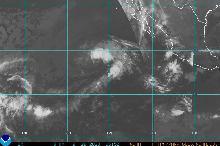
TS Henriette is now Hurrciane Henriette a Category 1 Hurricane with its outer bands approaching the southern tip of Baja California....

Henriette forecast storm position as of Sep 4 - 09:00 UTC was
Latitude: 21.4/ Longitude: -109.1
Maximum winds of 75 mph.


latest goes west infra red hurricane image


We will keep you posted!
RS

Felix Inbound Nicaragua UPDATED

This is an updated report.

Hurricane Felix a Category 4 and gaining strength. The storms current position as of
Sep 4 - 06:00 UTC is approximately 93 miles/ 80 nautical miles (Latitude: 14.3 Longitude: -81.9 off the Nicaragua coastline.

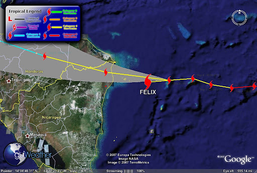
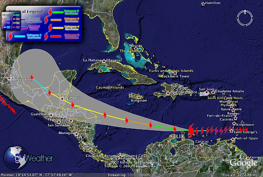
According to guiWeather track (see track below). The storms track indicates that the storm is currently deviating from its westerly track slightly to the south and if it maintains course will pass north of Pureto Cabezas on the Nicaragua coastline. The storm is packing maximum winds of 150 mph with a pressure of 940 mb.

Felix is moving toward the west near
20 MPH/32 KM/HR. A south westward track with some decrease in speed expected. The storm has strengthened and may further strengthen before landfall. Hurricane Force winds extend outward up to 35 miles and Tropical Storm Force winds extend outward to 195 miles.

This is a very dangerous storm. The deep ring of red in the satellite photo below indicate
intense thunderstorm or intense convection activity ongoing.


The track below also indicates that Felix is driving slightly south of it westerly track and will drive deep into Central America and we can expect
tropical torrential rains that can cause major flooding and mud slides in mountainous and low lying areas.


According to press reports," local officials pleaded with residents of Honduras, Nicaragua, Belize and Guatemala to evacuate low-lying areas especially Honduras’ nine offshore islands and otherwise prepare for inevitable disaster". Tourist have been evacuating resort areas jamming area airports.

On the Pacific side...

Tropical Storm Henriette is very close to becoming a hurricane. Henriette is tracking for tourist resorts in Baja California after killing seven people, five of them children, in Mexico's Pacific coastal state of Chiapas. Local Civil Protection Services reported that Henriette dumped torrential rains in Guerrero state on Friday, triggering a rockslide that buried six people in their homes in the resort city of Acapulco. Another man was killed when his vehicle was crushed under another rock slide in jungle ravine in neighboring Chiapas State.


TS Henriette current storm position as of Sep 3 - 18:00 UTC tracking North/Northwest at Latitude: 19.8 / Longitude: -108.3 with maximum winds of 060 knots with gusts to 075 knots.


Keep Posted!

RS

Monday, September 3, 2007

Felix the Cat -4 ! Update!

Central America is preparing for a battering by Hurricane Felix, which now a category four storm as it rages through the Caribbean.

Honduras expects to be hit Tuesday and has issued a hurricane warning for some coastal areas. With wind speeds now around 135MPH.

Felix was well above the minimum force for a category five storm. It comes just two weeks after Hurricane Dean killed 18 people in the region.


This makes Felix as well as Hurricane Dean stronger storms than any typhoons seen in the Pacific this year so far, even though Pacific typhoons are generally more frequent and powerful than Atlantic hurricanes.

Historically there have been 8 Category 5 hurricanes in the past 5 years (Isabel, Ivan, Emily, Katrina, Rita, Wilma, Dean, Felix).

This season there have been two Category 5's Dean and Felix; only three other seasons have had more than one (1960, 1961, 2005).


Felix is an awesome storm to watch. But its destructive power is something that we can do
without. Wind shear in the sector is very low and the hurricane is moving into the warmest part
of the Caribbean. Amazing drop to 64mb in just 24 hours. I have asked the NHC about this.
Though NHC thinkiing is that Felix may diminishing more in intensity when it hits the Honduran
coastline and then become a Cat 3 heading toward Belize. Will it pick back up as it enters
warmer waters?

We need to watch the track on this storm when it reaches the Bay of Campeche.

Stay tuned!

RS

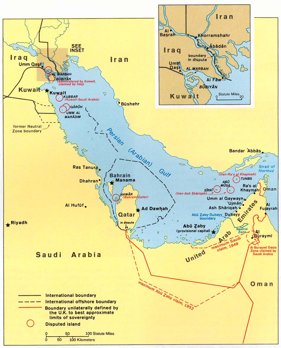
The Persian Gulf and Hurricane Felix

Once again I am going to start the blog about something that this blog was not created for, politics and war.

However, serious rumors of war with Iran have now hit my industry and that is not a good sign.

Yes I have a political point of view. And since this is not a political blog I will keep my political views to myself.

There are a plethora of blogs both right wing and left wing that can confuse a group of rocket scientists, so just do a web search and knock yourself out if your all ready blindly deposed one way or the other.

However as a professional marine salvor I wish to take a different approach in discussing the potential of going to war with Iran in the Persian Gulf .

The potential maritime and economic loss of war in the Persian Gulf to both sides as well as the rest of the world.

Most blogs and news reports focus on the ramification of going to war with Iran in terms of terrorism or in military terms. But there is another picture. The economic picture.
While I have no great love for the current Iranian regime and since I am sure, that most of the Iranian people do not wish to go to war with the United States, as most citizens of countries normally feel about going to war, unless they are attacked without just cause or buy a political hook, line and sinker. Yes we are not the only ones, try the German people during WWII and they paid a very heavy price, much heavier than anything we have ever paid.

While we are have the freedom of speech and opinion. Most of the time, none of us actually know what is really going on, but we all have some real interesting opinions. So I say to my readers, do not let the media or government meld with your mind, do your own research. And seriously research all sides then come to a conclusion.

Yes the United States Military is very capable of successfully striking Iran. Though we need to remember the British Falklands Island campaign. Ship losses took a heavy toll and we can expect the same thing in the Persian Gulf on both the military and merchant sides.

Daily in the Gulf there are some 30 merchant ships entering and exiting the Gulf every 24 hours. During both the Gulf War and the Iraq/Iran War the US and its Allies escorted some 9000 merchant vessel, even re-flagging some to the US Flag for additional protection. The Persian Gulf is a key economic waterway to the world.

Currently we have three Carrier Battle Groups operating in the Gulf. Depending on the mission each battle group can have as many as 12 or more combat ships within each of its groups. This is not just a strike force but a fleet protection force as well. Protection for both fleets, military and merchant.

Yes we know how and where to strike Iran and the Iranians know, we know, and they know how to strike back. Yes we are prepared to ensure that the Gulf remains open to the merchant fleet. You can also bet that the Iranians are prepared to attempt to close it down as well. They have done it before and odds are they will attempt it again.

So I end here. Not much has changed since the Iraq/Iran war except that weapons systems have advanced 10 fold and yes we have a huge advantage on that frront. But the same navigational and economic concerns and problems in the Gulf still exist.

Listed are some choice studies for my readers to start with. So as the political and media campaign to war starts remember, "do not let the media or government meld with your mind, do your own research" !


1. Iran-Iraq War 1980-1988
The Tanker War, 1984 - 1987

Much of Iraq's export capability was lost during the Iran-Iraq War, either to war-related damage or due to political reasons. In 1982, for instance, Syria (allied with Iran at the time) closed the 500-mile, 650,000-bbl/d-capacity Banias pipeline, which had been a vital Iraqi access route to the Mediterranean Sea and European oil markets. By 1983, Iraq's export capabilities were only 700,000 bbl/d, or less than 30% of operable field production capacity at that time.

Iran's revenue share fell after the 1978-79 Iranian Revolution, followed soon thereafter by the Iran-Iraq War for much of the 1980s. All Iranian onshore crude oil production and output from the Forozan field (which is blended with crude streams from the Abuzar and Doroud fields) is exported from the Khark Island terminal located in the northern Gulf. The terminal's original capacity of 7 million bbl/d was nearly eliminated by more than 9,000 bombing raids during the Iran-Iraq War.

The tanker war seemed likely to precipitate a major international incident for two reasons. First, some 70 percent of Japanese, 50 percent of West European, and 7 percent of American oil imports came from the Persian Gulf in the early 1980s. Second, the assault on tankers involved neutral shipping as well as ships of the belligerent states.

The tanker war had two phases. The relatively obscure first phase began in 1981, and the well publicized second phase began in 1984.


2. If Iran Provokes an Energy Crisis: Modeling the Problem in a War Game by James Jay Carafano, Ph.D. and William W. Beach

From December 2006 to March 2007, Heritage Foundation scholars conducted a computer simula­tion and gaming exercise that examined the likely economic and policy consequences of a major oil disruption in the Persian Gulf. The exercise utilized a realistic scenario, state-of-the-art macroeconomic modeling, and a knowledgeable team of subject-matter experts from government, business, aca­demia, and research institutes from around Wash­ington, D.C.

This project was a proof-of-principle investiga­tion that combined computer modeling and gaming to capture how U.S. decisions during a crisis might affect how global energy markets and the U.S. econ­omy adjust to sudden and significant disruptions of oil supplies. In this scenario, the United States responded to a crisis precipitated by an attempted Iranian blockade of the Strait of Hormuz.

3. The Future of Oil: Four Scenarios Standard & Poor's RatingsDirect

If anything underscores how geopolitical forces have played havoc with oil prices, it's the latest armed conflict in the Middle East, pitting the Israeli military against Hezbollah guerrillas in open warfare in Lebanon. Already heightened by the U.S.-led confrontation with Iran over its nuclear ambitions, fears about the stability of oil supplies have only increased since the Gaza bombings earlier in July and have intensified sharply since Israel began targeting Lebanon. The outcome is now even more uncertain than it appeared just a few weeks ago.

How long the conflict continues—and whether it spreads to surrounding countries—will determine the future of energy prices, at least in the short run. With Iranian President Mahmoud Ahmadinejad saying on July 25 that the fighting could trigger "a hurricane" of broader war in the Middle East, the prospects look dire to many observers—especially oil traders—around the world.

Having survived higher energy prices relatively unscathed so far, the U.S. economy is more sensitive to costlier oil now than it was a year ago. Inflation, even excluding energy, has accelerated, leading the Federal Reserve to raise interest rates 425 basis points in response. Consumers are already spending more than they earn. And Standard &Poor's expects the economy to slow down to 2.5% growth in gross domestic product in 2007 from an estimated 3.5% in 2006.

UNCERTAINTY PREVAILS. The falloff in U.S. growth means it takes a smaller shock to cause a recession than it did a year ago. Continued strong world oil demand, with usage in both China and Europe accelerating, will continue to put rising pressure on oil supplies despite a U.S. slowdown, thus raising the odds of an oil price surge causing a U.S. recession.

Whether the current Mideast conflict causes a recession depends mostly on how big the impact on oil supplies and prices becomes. This is still highly uncertain. At Standard & Poor's, we continue to believe that the most likely outcome is that cooler heads will eventually prevail and that oil prices will drop back from current peaks. (Of course, there are other, non-military factors—like hurricanes or production disruptions on the order of BP's [BP ] Aug. 6 closure of its Prudhoe Bay field in Alaska—that could have an effect as well [see BusinessWeek.com, 8/7/06, BP's Pipeline Trouble].)

4. TANKERS AT WAR - JAMES H. RAND 1984-1987
Published: 12 January 2001 00:00
Updated: 05 July 2006 17:09

In his first ‘Chairman’s Report’, in the 1984 Annual Report, Jim Rand noted that “promotion of free enterprise and safety at sea are key issues for INTERTANKO”.

Further, he added that “free competition has also for centuries been a cornerstone of American society”. Perhaps someone should have told the United States Congress. Although, for a change, no flag preference proposals gained any speed in Congress, American proposals for taxation of foreign shipping were tabled in 1986. These proposals required tax returns from foreign owners and planned to levy taxes according to American theories of the owner’s domicile rather than the ship’s flag - a burdensome intrusion.

American tax was not the main feature of this time. This was provided by the more spectacular events in the Middle East Gulf, where the Iran-Iraq War now made the waters of the Gulf one of its main theatres. Both sides routinely attacked non-military shipping regardless of its association in any way with either of the combatants.

In 1984, eleven Very Large Crude Carriers (VLCCs) were damaged beyond repair by military strikes. More seriously, 25 sailors were killed and 25 more injured in the attacks. Some tanker owners refused to sail their ships to load at the Iranian export terminal at Kharg Island, despite high freight rates obtainable.


Back to the Weather!

Latest on Hurricane Felix:

Felix becomes a Category Five!!

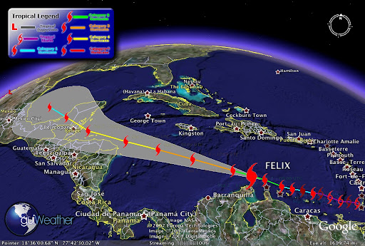
Felix's projected path is just north of Honduras, then Belize one more time!


And


- - click on image for animation - -

And

[full basin map of tropical cyclone activity]


More From Aruba!


Keep you posted!

RS
Sunday, September 2, 2007

Hurricane Felix Update - CAT 3


Hurricane Felix is now a "major" Category 3 hurricane as it rages over the warm waters of the Caribbean, aimed at Central America or Mexico's Yucatan Peninsula, NWS and NHC weather forecasters report.


Felix passing Aruba!


Latest Track!

FELIX -Current Storm Position as of Sep 2 - 18:00 UTC -Category 3 Hurricane
Maximum winds of 125 mph and a pressure of 964 mbLatitude: 13.4 Longitude: -71.2


Keep ya posted!

RS

Hurricane Felix

Well we have number two of the season and its name is FELIX and its a CAT 2

Its current storm position as of Sep 2 - 09:00 UTC. Latitude: 12.8 Longitude: -68.7 heading for the island of Aruba. Maximum winds of 100 mph and a pressure of 984 mb.

As of Sep 2 - 05:26 UTC. Hurricane Hunter KNHC AF306 just ahead of the storm reports, Altitude of Plane: 10036 feet. Wind Direction: 280°. Wind Speed: 32 knots. Temperature: 5°C Dewpoint: 5°C..
The storm was upgraded from a tropical storm to a Category 1 hurricane Saturday evening, becoming the second Atlantic hurricane of the season.

It had sustained maximum winds of at least 80 mph early Sunday. A tropical storm warning and hurricane watch were in effect for Aruba, Bonaire and Curacao.

At 2 a.m. EDT, Felix was centered about 45 miles northeast of Bonaire and 145 miles east of Aruba and was moving westward at about 18 mph, the U.S. National Hurricane Center said.

Forecasters said satellite images showed Felix steadily expanding in size.

Earlier in the day Felix brought heavy rains and strong winds to Grenada as a tropical storm, snapping small boats loose from their moorings, temporarily knocking out local radio and TV stations and toppling utility lines. No injuries were reported.


We got to keep an eye on this one!

RS