 Lets meet another brand of storm chaser. Unlike the ones we see chasing tornado's, these storm chasers are chasing something we normally do not see right away and that causes havoc and hell on water.
We have talked about rogue and dangerous waves. I have and will continue to post some extraordinary pictures and videos of these waves and what they can do to ships, cargos and lives. Today I want to talk about the potential of forecasting dangerous waves. This would be indeed a ma jor advancement and benefit to both meteorology and the maritime communities.
The study of rogue waves is just getting underway. As I have noted Dr. Paul C. Liu of NOAA's Great Lakes Environmental Research Laboratory (GLERL) has been studying these waves. GLERL has also been studying wave forecasting for the Great Lakes Region.
According to GLERL, " This project is designed to develop and fully implement a system of computerized models that can simulate and predict the three-dimensional structure of currents, temperatures, water level fluctuations, wind waves, ice, and sediments in the Great Lakes. The project will integrate these models with the required observational data systems into a real-time coastal prediction system. The project will make the information developed from this system available in a useful format and in a timely fashion to National Weather Service (NWS web site) forecasters, coastal users and resource managers".
NOAA/NWS has both a Ocean Prediction Center and Wavewatch III . But neither of these services accurately report on waves inside the Gulfstream. Why is this important? Currents or "moving water" play a important role in both effecting and determining dangerous waves. Why don't they report? Well its complex, they can to some degree but the technology is also not there yet to satisfy the powers to be. Maybe NOAA should consider this rather than spend $100 million on public relations? So lets take a look at another concept being proposed in wave forecasting called the; Gulfstream Hazard Scale, by professional satellite Oceanographer Jenifer Clark and husband Meteorologist Dane Clark.
In a letter date 18 July 2007 to the Director of the National Centers for Environmental Prediction, the Clark's state, " We have become increasingly alarmed by the large numbers of vessel sinkings and loss of life and property in the Gulfstream along the U.S. East Coast over the past several years. Just this spring, four more boats were sunk and four people were killed during an east coast storm that later became Tropical Storm Andrea -- even though this system was well forecast by NWS forecast models."
After talking with hundreds of mariners who have sailed in these waters over the years and recently completing a research report for a court trial involving the cruise liner "Norwegian Dawn", which was severely damaged with 400 passenger injuries in April 2005 after encountering 40-70 foot steep waves in the Gulfstream; we have concluded that mariners are not being adequately warned about the pote ntial danger when strong winds oppose strong ocean currents in the Gulfstream System (the main Gulfstream and eddies).
In the case of the Dawn, the Captain of that vessel testified that they had no idea they were sailing into those horrific conditions (see attached graphic). NWS forecasts indicated strong winds to 50 kts and significant wave heights to 27 feet, which were good forecasts outside the Gulfstream, but in the Gulfstream, seas were more than double that and these waves were much steeper and more difficult to navigate. Notations in the marine forecasts indicating "waves higher in the Gulfstream" were not very useful and mostly ignored since they are repeated in many offshore forecasts on a daily basis and contain no actionable data the mariner can use regarding the height or danger of these waves and their exact location.
Based on these and other cases we have examined, we feel that improvements are needed to alert mariners about specific threats about extreme and dangerous waves that exist in Gulfstream waters during these severe weather events, The highest risk area corresponds to the area of maximum ocean currents flowing northward (estimated at 5 kts) and winds recorded on the Dawn between 4-6AM on 4/16 at 50-55 kts blowing from the north. This is where an estimated 60-80 foot wave struck the Dawn and caused most of the damage and injuries. Wave heights were observed to be as high as 40-45 feet through the Gulfstream waters that night before the larger, steeper wave hit the ship.
Recent international research efforts to examine extreme wave events, termed MaxWave, have concluded that dangerous extreme waves are much more common than historically believed (and not uncommon, as the terms "freak wave" and "rogue wave" would imply). The studies further stated that current technology is incapable of precisely forecasting these extreme waves at present, but that there are areas around the world that are known "hot-spots" for extreme waves, like the Gulfstream, where strong winds often oppose strong ocean currents.".
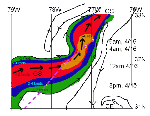
(Route ( chart above ) of the Norwegian Dawn (purple) on April 15-16, 2005 superimposed on Jenifer Clark's high resolution Gulfstream Analysis. The gulfstream maximum current is indicated by large black arrows, isolines of the estimated magnitudes of ocean currents are color coded and small arrows indicate the direction of flow of all ocean currents on this meso-scale chart.)
Therefore, using our experience and information from other mariners, we have developed a Gulfstream Hazard Scale which is similar to other environmental scales (tornados, hurricanes, river rafting, avalanches, etc.,) used to educate, alert and warn.
An important aspect of this scale is the increased potential for extreme waves, as the scale increases from Cat 0 to Cat 8. These are correlated to specific recommended responses to the risk, or threat levels.
This scale is a concept and has not been used operationally. Since it is subjective in nature, we expect that modifications may be needed before it could be used to develop warning products. The most important parameters required are detailed, real-time ocean surface currents in the Gulfstream area (Jenifer has been doing this on a daily basis for nearly 30 years) and real-time and forecasts of meso-scale surface winds (available from the NWS models).
As you can read in the Clark's letter and as I have pointed out in some of my past posts, the Hatteras Trench region is a very well known maritime grave yard due to the storms fueled by the gulfstream and its winds. As we can read in their letter, we do have a hole in assisting mariners in forecasting these events. Some of the factors involved in the proposed Gulfstream Hazard Scale will include;
CAT - Categories 0-8, Risk - Threat to vessels from extreme or dangerous waves -- WD/OP/CUR - wind opposing the current. DUR - duration and fetch of the wind. SIG/WV/HGT - significant wave height (as per the international definition) -- an average maximum of the highest third of the waves in the wave spectrum, X/WAVS - Extreme wave potential, Marine/Guide - situation and recommended actions per category, (*) - generally taken as surface winds blowing against or quartering against the flow of the gulfstream currents (main stream or eddies).
Also note the opposing winds to current from both northern quadrants . Remember strong winds in one direction with strong currents in the opposite direction can produce some very strong and active waves. Though some studies have shown that strong winds blowing from any directio n over gulfstream currents can also cause dangerous wave actions.
Its really this simple. Strong winds, strong currents, over time, means, very large waves. Its about being able to warn mariners in advance about these waves that can save ships, cargos and especially lives.
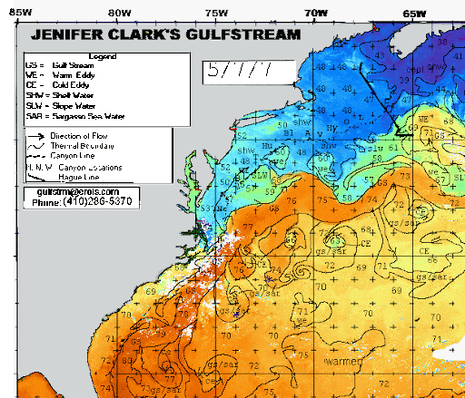
For further information on the Gulfstream Hazard Scale please visit, Jenifer Clark's Gulfstream.
RS


![[Valid RSS]](valid-rss.png "Validate my RSS feed")