 Deans Curerent Position:
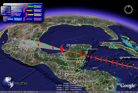
Dean's, current storm position as of Aug 22 - 00:00 UTC. Dean is now a Category 1 Hurricane and may re-strengthen with maximum winds currently of 80 mph and a pressure of 970 mb, tracking Latitude: 19.7 Longitude: -92.2.
Weather Bouy - 42055 just north of Dean reports as of Aug 22 - 00:50 UTC. Temperature: 85.3°F. Wind: NNE at 36 mph gusting to 45. Pressure: 1005.2 mb. Wave Height: 8 ft . This storm still has some power remaining in it. Matter of fact Weather Bouy 42056 just of the coast of Cozumel reports as of Aug 22 - 00:50 UTC. Temperature: 83.8°F. Dewpoint: 77.4°F. Wind: ESE at 22 mph gusting to 27, Pressure: 1011.6 mb, Wave Height: 8 ft. Still 8ft SWHs!
According to Hurricaneville "The storm became a hurricane as of the 5:00 AM EDT Advisory on Thursday morning. With its latest intensification, Dean became the tenth most powerful storm ever in the Atlantic ahead of Hurricane Janet (1955) and Hurricane Isabel (2003), and right behind Hurricane Ivan (2004). It is also the third strongest hurricane to make landfall in North America behind Hurricane Gilbert and the Labor Day Hurricane of 1935. The forecast track has the storm continuing across the Yucatan over the next days, and possibly emerging into the Bay of Campeche region of the Gulf of Mexico later on Tuesday and going into Wednesday as a Category Two Hurricane with 100 mph winds. Forecasted rainfall amounts for the affected areas are expected to range at least between 5 to 10 inches with some locales getting up to 20 inches over Southern and Central Mexico as well as Guatemala. On top of that, storm surge levels could go as high as 6 to 8 feet to the north of the potential landfall point within the Hurricane Warning area."
Beau's Weather Blog has a play by play of some of the more dramatic images of Hurricane Dean. Its well worth the time to take a look.
According to FEMA's National Situation Report on Dean states;
Tropical Weather Outlook
Atlantic/Caribbean/Gulf of Mexico:
Category five hurricane Dean makes landfall on the east coast of the Yucatan Peninsula of Mexico.
At 5:00 am EDT, August 21, 2007 the center of Hurricane Dean was located about 35 miles east-northeast of Chetumal, Mexico and about 195 miles east-southeast of Campeche, Mexico. Dean is moving toward the west-northwest near 20 mph and a west-northwestward to westward motion is expected today and tonight when the center will cross the Yucatan Peninsula and likely reach the southern Bay of Campeche.
Maximum sustained winds are near 165 mph, with higher gusts. Dean is a category five hurricane on the Saffir-Simpson Scale. Although some weakening is forecast as Dean crosses the Yucatan peninsula, Dean is expected to maintain hurricane strength throughout the next 24 hours.
Hurricane force winds extend outward up to 60 miles from the center and tropical storm force winds extend outward up to 175 miles.
The hurricane hunter plane reported a minimum central pressure of 906 mb (26.75 inches) just before landfall.
Storm surge flooding of 12 to 18 feet above normal tide levels along with large and dangerous battering waves is possible near and to the north of where Dean made landfall along the east coast of the Yucatan Peninsula.
Dean is expected to produce storm total rainfall of 5 to 10 inches over the Isthmus of Tehuantepec and Yucatan Peninsula of Mexico, Belize, Guatemala, and northern Honduras with maximum amounts up to 20 inches.

RS


![[Valid RSS]](valid-rss.png "Validate my RSS feed")