 While we were tracking Hurricane Dean in the Gulf of Mexico, we here in Chicagoland had our own interesting weather for the past few days. Thursday August 23, 2007 was the worse.
(Photos and story courtesy WGN Weather Blog).
Matter of fact the entire region from Iowa to Indiana to Illinois to Michigan suffered from severe storms.
NIU DeKalb Campus declared an emergency closure. In a statement the university stated;
"Due to potentially worsening flood conditions on our DeKalb campus, the university has declared an emergency closure and urges those personnel who are not designated as essential to emergency services to leave campus as soon as possible.
Only two bridges in DeKalb are currently passable, and with additional rain forecast, travel throughout the county is likely to grow increasingly difficult as the day goes on.Due to the status of this action as an emergency weather closure, personnel will not need to use leave time.The university*s regional centers in Rockford, Naperville and Hoffman Estates are not affected by this closure and remain open. Please use caution in traveling due to flooding road conditions."
Thursday was some of the worse weather Chicago has seen in years.
I was downtown during the height of the storm and clocked wind gusts at 63 MPH along N. Michigan Avenue, with wind driven rain where most trying to walk N. Michigan Avenue were doing so without much success. To say the least, umbrellas were useless.
Damage in my immediate area was limited to fallen trees around N. Michigan and Lakeshore Drive. Flooding was extensive along Lakeshore with beach access tunnels flooded. Ohio Street beach also flooded.The lightning show was just fascinating as well as dangerous.
Here are just some of the other damage reports from the region.
310,000 powerless in Chicago area
The Associated Press
About 310,000 customers in northern Illinois were without power Thursday night, including 62,000 in Chicago, said ComEd spokesman Tom Stevens, who added that it could take days to restore power for some customers north of the city.
People who ventured out to survey the storm's aftermath dodged felled trees, downed power lines and other debris knocked about by high winds.
Chicago officials said the city's emergency center been called for nearly 1,300 "tree emergencies," which included uprooted and split trees and limbs blocking intersections.
Langford said trees in several areas of the city hit power lines and exploded transformers, setting utility poles on fire.
"This is not a storm that's isolated," said Chicago Fire Department spokesman Larry Langford. "This one hit the entire city north to south."
A roof collapsed at the dock area of an industrial building in the suburbs, injuring 40 people, authorities said. West Chicago Police Department spokesman Mike Uplegger said seven people were sent to hospitals and the rest refused treatment at the scene. None of the injuries was considered life threatening.
A large piece of metal scaffolding at Northwestern Memorial Hospital's Prentice Women's Hospital collapsed during the storm, and two people suffered minor injuries but refused treatment, Langford said. Also, the rear wall of a four-story building under construction on Chicago's North Side collapsed, but no injuries were reported, he said.
Officials warned residents to prepare for flooding, with one to two inches of rain drenching on an already waterlogged area.
"That's what we're worried about right now," said National Weather Service meteorologist Nathan Marsili. "It could turn out to be a pretty bad flooding situation for the area."
Elizabeth Schreiber, who works at a public relations firm in Chicago, was in a cab returning from a work lunch when she looked out the window and noticed a tree had smashed into her 1998 Toyota Camry.
The uprooted tree lay across two other vehicles and her car, completely crushing its roof.
"It looks crazy around here," she said while waiting for help. "It's really bad."
Matt Steinkraus, 29, of St. John, Ind. — in Chicago for his wedding on Saturday — was walking downtown with his fiancee and friends when the storm struck.
"As soon as it hit, we made a break for the nearest bar," he said. "We got drenched ... then we went into the bathroom, wrung out our shirts, ran them under the dryer."
About 500 flights were canceled at O'Hare International Airport Thursday evening and passengers should expect delays of more than 2 1/2 hours, according to Chicago Aviation Commissioner Nuria Fernandez. Delays at Midway Airport averaged 1 1/2 to 2 hours.
Judy Pardonnet, a spokeswoman with Metra commuter rail system, said there were delays throughout the system because of debris on the tracks and malfunctioning signals.
"It's going to be a slow commute home for us," she said.
The National Weather Service would not be able to confirm tornado touchdowns until Friday, meteorologist Gino Izzi said. He said 74 mph wind gusts were recorded in Midlothian and near Wrigley Field.
As the storms rolled through, officials feared flash flooding. Some areas of northern Illinois could see 3-5 inches of rain — of particular concern because the ground is so saturated with water from recent rains, Izzi said.
"If that happens, you could be talking very serious flooding," Izzi said.
In Fox Lake in far-northern Illinois, the Fox River flooded some homes while other residents stacked sandbags to protect their houses, said Ami McEwan, assistant administrator for Lake County.
"Most of them are sandbagging and keeping it at bay," she said.
In downtown Gurnee, just west of Waukegan, workers were stacking sandbags to protect an elementary school from the Des Plaines River, she said. School hadn't yet started for the fall, so no students were affected.
A foot of water stood over roads in the Rochelle area, about 20 miles west of De Kalb, and the Des Plaines River was more than 3 feet above flood stage north of Waukegan, according to the weather service.
An afternoon storm that included high winds uprooted trees and damaged homes and knocked out power across Galesburg, about 40 miles northwest of Peoria, according weather service and local authorities. The storm also blew the windows out of a church in nearby Toulon, and knocked out power lines across Stark County, just north of Peoria.
Trees and limbs were down all over town, but no one was hurt by the fast-moving storm, Galesburg Fire Department Battalion Chief Brad Stevenson said.
"It was such a broad area, and it came up so quick and was gone so quick," he said.
From the Desmoines Register
By SARAH LEFEBER
REGISTER STAFF WRITER
August 24, 2007
Humboldt County's disaster services coordinator is in serious condition in a Mason City hospital after his vehicle struck a utility pole while he was assessing storm damage Tuesday night.
Humboldt County Sheriff Dean Kruger said Doug Wood was driving near Bode when he hit a pole that had fallen during the storm.
Kruger said he was talking to Wood on his cell phone about 8:30 p.m. as Wood was driving on County Road P-33. "The next thing I heard was 'Oh no,' and then I heard a clunk, and that was the last contact I had with him," Kruger said.
When officers found Wood, his vehicle was in a ditch with power lines down on the road around him. Rescuers waited about 30 minutes for MidAmerican Energy to shut off the power before they were able to get Wood out of his vehicle.
Wood was taken by ambulance to a Humboldt hospital and transferred to Mercy Medical Center in Mason City. He remained in serious condition with a severe head injury.
Reporter Sarah Lefeber can be reached at (515) 284-8065 or slefeber@dmreg.com
Here is a summary by NWS.
738 NOUS43 KLOT 250048 PNSLOT PUBLIC INFORMATION STATEMENT NATIONAL WEATHER SERVICE CHICAGO IL 747 PM CDT FRI AUG 24 2007 .
..STORM SURVEYS CONDUCTED ACROSS PORTIONS OF DEKALB...DUPAGE AND COOK COUNTIES...
...STRAIGHT LINE WIND DAMAGE FOUND ACROSS DUPAGE AND COOK COUNTIES...
SEVERE THUNDERSTORMS CAUSED EXTENSIVE WIND DAMAGE ACROSS PORTIONS OF NORTHERN ILLINOIS THURSDAY AFTERNOON.
NATIONAL WEATHER SERVICE STORM SURVEY TEAMS EXAMINED WIND DAMAGE IN SEVERAL LOCATIONS ACROSS DEKALB...DUPAGE AND COOK COUNTIES ON FRIDAY. ACROSS DUPAGE AND PORTIONS OF NORTHERN AND CENTRAL COOK COUNTIES...A NEARLY CONTINUOUS SWATH OF WIND DAMAGE WAS NOTED. THE MOST SIGNIFICANT DAMAGE OCCURRED ALONG A PATH WHICH BEGAN IN FAR WESTERN DUPAGE COUNTY NEAR THE INTERSECTION OF ROOSEVELT ROAD AND WASHINGTON STREET
IN WEST CHICAGO...AND CONTINUED EAST THROUGH THE NORTHERN PORTIONS OF LOMBARD AND GLEN ELLYN...INTO NORTHLAKE...THEN ACROSS THE NORTH SIDE OF CHICAGO TO THE LAKE MICHIGAN SHORE NEAR MONTROSE HARBOR. ALONG THIS PATH...WIND DAMAGE WAS CONSISTENT WITH WINDS IN THE 60 TO 80 MPH RANGE.
HOWEVER...THERE WERE POCKETS OF WIND DAMAGE SUGGESTIVE OF WINDS IN THE 80 TO 100 MPH RANGE INCLUDING THE 4200 BLOCK OF NORTH ASHLAND AND ACROSS NORTHERN GLEN ELLYN SOUTH OF GENEVA ROAD. THE WIND DAMAGE WAS APPROXIMATELY ONE HALF MILE WIDE ALONG THIS PATH. A SEPARATE AREA OF WIND DAMAGE SUGGESTIVE OF WINDS OF 80 TO 100 MPH WAS FOUND IN THE 4000 BLOCK OF NORTH SHERIDAN IN THE WRIGLEYVILLE AREA WITH EXTENSIVE TREE DAMAGE AND SEVERAL UPROOTED TREES IN THIS AREA. MUCH OF THE DAMAGE APPEARS TO BE CONSISTENT WITH STRAIGHT LINE WINDS...WITH NO SIGNS OF SUSTAINED ORORGANIZED CIRCULATION OVER THE MAJORITY OF THE DAMAGE PATH. ...
EF1 TORNADO DAMAGE FOUND IN WESTERN DUPAGE COUNTY... WHILE OTHER DAMAGE APPEARS TO HAVE BEEN CAUSED BY STRAIGHT LINEWINDS...DAMAGE INDICATING A TORNADIC CIRCULATION WAS FOUND IN WINFIELD IN WESTERN DUPAGE COUNTY. THE TORNADO BEGAN NEAR PRINCE CROSSING ROAD SOUTH OF GENEVA ROAD. THE TORNADO HAD A PATH LENGTH OF APPROXIMATELY 1.5 MILES AND ENDED JUST WEST OF GARY AVENUE SOUTH OF GENEVA ROAD. THE MAIN DAMAGE FROM THE TORNADO INCLUDED SEVERAL LARGE UPROOTED HARDWOOD TREES. BASED ON THE OBSERVED DAMAGE...THE TORNADO IS ESTIMATED TO HAVE BEEN APPROXIMATELY 300 TO 500 YARDS WIDE AND RATED EF1 ON THE ENHANCED FUJITA SCALE WITH ESTIMATED WIND SPEEDS OF 86 TO 110 MPH. PRELIMINARY REVIEW OF RADAR DATA AND SPOTTER REPORTS INDICATE THAT THE TORNADO OCCURRED AT APPROXIMATELY 308 PM CDT. ...
ADDITIONAL SURVEYS...
IN DEKALB COUNTY....MINOR STRAIGHT LINE WIND DAMAGE TO LIMBS AND A SHED DOOR WERE FOUND ACROSS THE MILAN...AFTON...PIERCE AND KANEVILLE TOWNSHIPS SOUTH AND SOUTHEAST OF THE CITY OF DEKALB. IN MOUNT PROSPECT IN NORTHERN COOK COUNTY...ROOF AND EXTERIOR WALL DAMAGE WAS NOTED TO A ONE STORY GARAGE BUILDING IN AN APARTMENT COMPLEX SOUTHWEST OF THE INTERSECTION OF GOLF ROAD AND BUSSE ROAD.
DAMAGE APPEARED TO BE ASSOCIATED WITH STRAIGHT LINE WINDS OF 80 TO 100 MPH. THROUGHOUT THE VILLAGE...NUMEROUS LARGE BROKEN TREE LIMBS...SOME UPROOTED TREES AND A FEW SNAPPED TREE TRUNKS ALSO APPEARED TO BE CONSISTENT WITH PEAK STRAIGHT LINE WIND SPEEDS OF 80 TO 100 MPH.
$$ IZZI/MERZLOCK/MARSILI/RATZER
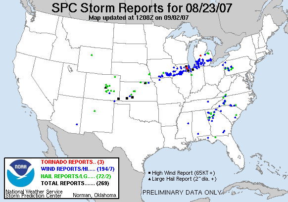
SPC Storm Prediction Center Report for August 23, 2007
| <> 070824 Reports > | |||||||
 |
FEMA National Situation Update
State Flooding & Severe Weather Reports
Region V Illinois
Severe storms moved through northeast Illinois (Chicago area) in the afternoon on August 23, 2007, causing power outages, downed trees, and roof damage to several buildings.
One fatality has been confirmed in Knox County due to a falling tree. No other injuries have been reported to the State.
Power outages have been reported in Cook County, Knox, LaSalle and Warren Counties.
At 3:30 pm CDT, August 23, 2007 the Exelon Nuclear Power Plant at Braidwood had one unit manually shut down by the operators due to loss of vacuum. The loss of vacuum was caused by the automatic shut down of 2 circulating water pumps when the pumps experienced fluctuations. This is standard protocol with this type of mechanical failure and the reactor was shut down without incident.
Braidwood Unit 1 is still at power and both reactors at the Braidwood site are stable. This is not a classifiable incident under NRC regulations and poses no danger to the public or the workers at the station. The US NRC has been notified. The IEMA resident inspector is on-site.
The majority of damages reported have been minor.
The State EOC is being staffed, but has not been activated. The State has requested Illinois State Patrol, Illinois Department of Transportation, Illinois Department of Natural Resources, External Affairs and a Legislative Liaison to report to the EOC. There have been no requests for State Assistance. Continue reading...
And finally, Lets go to the video tapes!
This weekend has a much brighter outlook!
RS


![[Valid RSS]](valid-rss.png "Validate my RSS feed")