 Can Pollution Cuase Tornadoes?
Dust particles pumped out by industry, agriculture and transport could be the catalyst that makes a nasty thunderstorm switch into a spawning ground for tornadoes.
Researchers from Colorado State University who have been seeking a greater understanding of the twisters that plague the American Midwest each year believe that particulate matter could be partly to blame for the devastating problem.
Their research was based on computer modelling rather than field observations and sampling and could shed some light on the mystery of why some so-called supercell thunderstorms blow themselves out while others crank up the extreme weather a notch and generate twisters which rip through the landscape.
The team compared two computer models - one with clear air and the other with a high level of fine particulate matter.
In the clear-air model, tornadoes never quite formed, while in the pollution-heavy model, they did with some frequency.
David Lerach, leader of the research team, admits it is still unclear as to why exactly this might be but says it could be that the dust prevents water in the atmosphere from condensing into big enough droplets to fall as rain, thus stopping the storm from breaking.
Instead of falling as rain, he believes that warm air carries the tiny water droplets high into the cloud where they freeze and this process effectively leaves the way clear below for the rotating air currents that are the precursor to tornadoes.
WEATHER NOTE
TORNADOES.....TORNADOES......TORNADOES..........
Super cell on brink of tornado
November 17th, 2008
A STORM chaser says a 130km/h 'super cell' that hit the northern Gold Coast and Hinterland yesterday almost turned into a tornado.
Houses and cars were severely damaged in the small rural community of Wonglepong and roofs were damaged when trees landed on cars at Mount Tamborine, Canungra and in the Ormeau and Wongawallan areas.
The Scenic Rim SES unit received more than 20 calls for jobs mainly relating to roof damage as storms moved through from the southwest about 4pm.
At one stage police told motorists to avoid travelling to Mount Tamborine due to severe storm damage and road closures throughout the area.
Powerlines were brought down on Main Western Road, Hartley Road and Lahey Road, blocking access for several hours.
A large tree fell on to the northbound lane of the M1 at Robina about 6.30pm.
A severe weather expert said the super cell had produced winds of at least 130 km/h.
Gold Coast member of the Australian Severe Weather Association Jeff Higgins, who chases storms on a regular basis, said the cell was close to becoming a tornado.
"Conditions were ripe for the formation of a tornado and this particular cell went close to producing one," he said.
"Even though a tornado didn't form, it had the same strength of being a tornado."
He said at 3pm he recorded 161 lightning strikes per minute and 70ml of rain in just 10 minutes.
"That storm was life-threatening due to the trees going down and powerlines," said Mr Higgins, who predicted similar storms on Wednesday and Thursday this week.
Scenic Rim SES local controller Brendan Guy said the Mount Tamborine area was hit hardest by the storm.
"Most of the jobs were on the mountain, they were for trees falling on roofs and skylights being damaged," he said. "There are a lot of trees down, powerlines down, it's a big mess.
"Two homes in Wongle-pong lost their roofs.
"They were on the same property.
"The family were able to go to a third house on the property for shelter for the night."
The Vonda Youngman Community Centre on Mount Tamborine was damaged when a tree fell on its roof.
Mount Tamborine resident Chris Watts reported hail the size of golf balls.
"It was pretty full on, and the wind was pretty wild," he said.
SES volunteers were expected to work through to midnight, clearing roads blocked by trees felled by the storm and repairing roofs.
Wonglepong resident Peter Brown watched as trees were blown down in his property, one narrowly missing his house before it demolished his fence and brought down powerlines.
"It sounded like a bomb going off. We thought it was lightning," he said.
"Hail was hitting the windows, I thought they were going to crack.
"We've had storms but nothing like this. It's never been this scary before."
For all the storm's fury, Mr Brown said it was over in 15 minutes, but the power was out for four hours.
Next door, Colleen Brown had the fright of her life when a large branch speared through the side of her house.
"I've never seen anything like it. We were lucky I suppose," she said.
North Carolina storm kills 2, destroys homesKENLY, N.C. --As a tornado ripped through his North Carolina neighborhood, Curt Jernigan huddled in his bathroom, praying for the raging winds to spare him.
When Jernigan emerged from the home, he met a neighbor, his face covered in blood, who pleaded with him to help search for his wife. She had gone missing in the confusion of the storm. The 41-year-old Jernigan agreed to help out, but said he knew the effort to find the woman alive would be fruitless.
"When I saw what he had in his yard, I knew it wasn't going to be a rescue -- it was a recovery. It's just devastation," Jernigan said.
His grim thought proved correct. State police said his neighbor, Maryland Gomez, who was in her 60s, was one of two people killed by tornadoes and severe weather that swept across central North Carolina early Saturday.
Gomez's body was found amid the rubble that was once her home in Kenly, a community about 35 miles southeast of Raleigh, said state police spokeswoman Patty McQuillan. In neighboring Wilson County, authorities said a child also was killed. Several people were injured in the cluster of strong storms that hit some six counties.
The only thing left standing of Gomez's home was her front porch, one of at least a half-dozen houses destroyed by the storms that also knocked down trees and power lines. Residents emerged at daybreak to find their homes in ruins, cars flipped over and debris strewn about.
"It was pretty massive destruction," Johnston County emergency management coordinator Derrick Duggins said. "It goes to show the magnitude of what natural weather can do.
In Kenly, family and friends piled up mattresses, took pictures of the damage and filled garbage bags with trash from Mark Stephenson's one-story brick home, leveled by the storm.
Winds tossed family portraits into the woods some 200 yards away and the skeleton of a new camper the Stephensons had just bought sat nearby.
One half of Stephenson's home was flattened, while a tree had fallen through the other half, on top of his 19-year-old daughter's bedroom. She was taken to a hospital with non-life-threatening injuries.
"It's hard to believe, it's hard to take in," Stephenson said. "We've got our lives and our health, so we're good to go."
His 14-year-old son, Hunter, pointed to what used to be his bedroom -- now just a pile of bricks and beams. The room was being remodeled, so Hunter had been sleeping in the living room.
"I'm lucky," he said. "It's crazy, if I would have been in there, I would have been dead."
U.S. Rep. Bob Etheridge, who represents the area, surveyed the damage Saturday, describing beams in the home where the woman was found as spaghetti-like. Gov. Mike Easley planned to tour the area Sunday or Monday after local officials have assessed the damage.
A Red Cross shelter was opened at a church and National Weather Service officials were sending crews out to survey the damage.
On the morning of Wednesday, November 15, 1989, it appeared that a significant severe weather outbreak was likely. The early morning convective outlook called for a moderate risk for severe weather over much of Alabama, Mississippi, southern Tennessee, western Georgia and the Florida Panhandle, warning that there could be significant tornadoes. The NWS Birmingham called the system impressive.
By midmorning, the risk category was upgraded to high. The system was becoming more impressive according to forecasters. All Weather Service offices in Alabama were urged to review staffing levels and bring in additional personnel for the event. Huntsville was short staffed, so an intern was dispatched from Birmingham.
PDS (Particularly Dangerous Situation) tornado watches were issued; the first coming just after noon for Northwest Alabama. At 1:20 p.m., it was noted that storms were intensifying over Northeast Mississippi. At 1:35 p.m., a tornado watch was issued for the rest of Alabama. Lifted indices over Mississippi were as low as -9. Very strong upper level winds associated with a jet max were moving into position over Alabama and Mississippi. Winds were divergent in the upper atmosphere and there was a strong dry punch moving across Mississippi.
At 2 p.m., I sat at my desk at the Sheraton Perimeter Hotel with a late lunch and plotted the latest surface observations. I drew this surface map. The dewpoint at Birmingham was an impressive 68F. As I connected the pressure plots in isobars, I gasped at the sight of a strong mesolow over Northeast Mississippi.
This meant trouble. That low would provide the backing winds at the surface that could help spin up tornadoes. I packed my things and headed home so that I could watch the situation unfold on television as the impressive squall line appraoched Northwest Alabama.
The first severe thunderstorm warning was issued for Northwest Alabama’s Colbert, Franklin and Lauderdale Counties at 2:43 p.m. It was extended to Lawrence County just after 3 p.m. At 3:40 p.m., the warning was upgraded to a tornado warning based on a hook echo indication.
Just before 4 p.m., the warning was moved over to include Limestone and Morgan Counties. At 4:13 p.m., a warning was issued for Limestone, Madison and Morgan Counties, but it was a severe thunderstorm warning since the hook had disappeared on radar.. The text did state that severe thunderstorms can and occasionally do produce tornadoes. Large hail was falling at Decatur. At 4:15, a wall cloud was observed from the NWS office at the Huntsville International Airport, but it dissipated.
At 4:20 p.m., a wall cloud was reported by NASA meteorologists at redstone Arsenal. At 4:25, rotation was observed.
By 4:27, the radar became useless as the storm moved overhead, its beam attenuated by heavy rain and hail.
The tornado was forming over the Arsenal, however, near Fowler Road and Mills Road. It touched down and started moving northeast.
The amateur radio network was up and operating in Huntsville with an operator at the NWS. At 4:30 p.m., conflicting reports came in from spotters about a tornado on the ground in the old Airport area of Huntsville.
By 4:33 p.m. as the sunset, the sky over Huntsville was ominously black. And the tornado reports were starting to pour in. The tornado had hit the Police Academy.
A deadly situation was developing, right in the middle of rush hour.
At 4:35 p.m., a meteorologist began creating a tornado warning in the SRWarn program on a PC. This allowed for rapid composition of messages. At the same time, the warning was given live on the NOAA Weatheradio with the tone alert. The location was incorrectly given. It would be corrected in the formal warning.
There was a short delay as the warning was transmitted over the AFOS computer, the backbone of the Weather Service automation at the time. The warning was sent out at 4:39 p.m.
But on WAAY, CHannel 31, meteorologist Gary Dobbs was live. He reported that there had been damage in Leighton in Colbert County, including a building collapse, as well as other damage. He have the severe thunderstorm warning for Limeston, Morgan and Madison County. He mentioned reports of funnel clouds.
A producer handed him a report of a tornado on the ground at the Huntsville Golf Course. A few seconds later, the producer told him that a tornado was on the ground at the Municipal Golf Course near the Armory.
The tornado was moving into a heavily populated area. It immediately crossed Memorial Parkway, which was highly congested with rush hour traffic.
The City of Huntsville was ensconced in an inky blackness as the 55,000 foot thunderstorm knocked out the electricity. Eerie bright flashes of light punctuated the darkness as the tornado ripped down power lines and tranformers blew.
Dobbs relayed the frightening reports to his audience as they were given directly to him. “The tornado is over the Parkway at Airport Road. Lots of damage.”
Between the Parkway and Whitesburg Road, the F4 tornado found plenty to detsroy, including apartment complexes, office buildings, churches and shoppng malls. Nineteen of the 21 fatalities occurred in this short stretch of the path, including eleven people in cars. Another fatality occurred in an automobile on Garth Road. Many never saw the tornado, and had no chance to escape.
At Jones Valley Elementary School, thirty seven students and 12 adults were present. An extended daycare program was in progress.
Principal Marilyn Dawson was concerned about the weather. Dawson was very weather aware. She had attended an emergency preparedness seminar in Birmingham in the spring.
The principal had been monitoring the NOAA Weatheradio all day. She gave the Weatheradio to lead teacher Penny Cato before leaving at 4:15 p.m.
Ms. Cato and the four other teachers led the students from their second floor classrooms to a stairwell on the lowest floor. She took the Weatheradio outside at 4:20 p.m., and heard the severe thunderstorm warning. It was raining heavily and there was lots of ligthning.
The lights flickered at 4:33. At 4:36, the tornado struck the school. The seven painters and teachers threw themselves over the kids, as glass and concrete rained down on them.
The actions of Ms. Dawson, Ms. Cato, the teachers and the painters likley saved several lives.
The tornado caused lots of destruction in the Jones Valley subdivision.
The Huntsville Tornado was on the ground for 18.5 miles. It destroyed 259 homes, 80 businesses and two schools. Twenty one people died and 463 people were injured.
Oh yeah....and a waterspout in Aussieland!

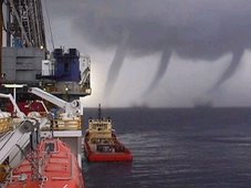
Water spout snakes through Darwin Harbour
DANIEL BOURCHIER
November 17th, 2008
A TERRITORY fisherman has stumbled on a natural spectacle - a water spout rising from Darwin Harbour into the clouds.
NEWSBREAKER Jason Rogers spotted the towering wonder as he was returning to Darwin from an early morning fishing trip to Melville and Bathurst Islands.
Mr Rogers, 39, spotted the phenomena at 6.50am Thursday. The seasoned fisherman, who visits Darwin regularly from Brisbane, could count on one hand the times he has seen a water spout.
"It was pretty cool," Mr Rogers told the Northern Territory News.
"It went right up to the clouds.
"I would have liked to have been a bit closer - I was actually getting photos of the sunrise when I spotted it."
Weather bureau severe weather forecaster Todd Smith said the water spout was not too out of the ordinary, but they were usually only seen in the morning.
"A water spout is generally a rotating column of air that often forms under a thunderstorm," he said.
"Sometimes they move over land and can be particularly damaging.
"They can pull up mangrove trees and there have been reports of them coming ashore and tipping boats over."
Mr Smith said water spouts tend to last for as little as a few minutes.
There have been reports of water spouts dropping fish when they come over land, but Mr Smith said that sounded unlikely.
"I haven't heard of that," he said "There is potential for a bit of suction, but I imagine it would be a bit of water from the top and only for a few minutes."
Well if Waterspouts in Ausieland ain't enough?
November 10th, 2008
THE skies over the Top End staged a lightning show a la extravagancy on Saturday night.
NEWSBREAKER Jacci Ingham captured a glimpse of the storms from the Arnhem Highway in Darwin's rural area.
The 27-year-old storm chaser and amateur photographer said the line of storms approached Darwin from the east.
"It started in the evening over Kakadu," she said.
"It was a big line of storms, but it sort of skipped Darwin."
Striking lightning images from across the Territory
Darwin airport recorded 108 lightning strikes within a 50km radius Saturday night.
The storm spent a couple of hours around Darwin, before hitting the sea where it became active again.
Despite the lightning show, most of the Top End remained dry.
Ms Ingham, of Wagaman, has lived in the Territory all her life.
She said she loved the wet season.
One last thing.....Here comes .....WINTER!
Winter is coming. Whether you love it, hate it, or just tolerate it, winter is coming. The best way to survive winter in northern Illinois and northwest Indiana is to be prepared.
November 16 through 22 is Winter Weather Preparedness Week in Illinois and Indiana
MARITIME NOTEMUMBAI: Is the august body of International Association of Classification Societies (IACS) cracking up? This seems to be the dominating thought running through not only among the 10 - member group and the majority 60 odd other such societies spread across the world but also a whole lot of ship owners and shipping professionals.
Even though the reasons that led to the January raids by the European Union (EU) on IACS and its members are still a mystery, the resultant anxieties and worries are now finding expressions in the world media.
Anti-trust inspectors of EU launched dawn raids on the offices of IACS and European classification societies in January, seeking evidence of them working together to reduce competition. It has since become apparent that the societies were under instruction not to comment on the aftermath of the raids.
The murmurs that followed the dawn raids became loud with, what one newspaper reported as, 'Clash of titans' when Det Norske Veritas (DNV) maritime chief operating officer and immediate past chairman of IACS Tor Svensen refuted American Bureau of Shipping (ABS) boss Robert Somerville's observations about 'sustained campaign against class threatening safety.'
It started off with Mr Somerville telling a recent IUMI insurance conference in Vancouver that the EU campaign would erode safety at sea and Brussels' competition authority DG Competition may turn IACS into a fairly loose trade association. "EU wanted to change or end the marine classification system," he said, adding, "The campaign against the IACS will erode safety at sea by turning it into a loose trade association... so diluted as to be largely irrelevant." Mr Somerville fears that the moves from Brussels amount to an attack on the independence of the quality system, while any attempt to open up IACS to all-comers will see the association lose all of its effectiveness.
"If IACS dies, the de facto technical division of the international maritime organization closes down," said Mr Somerville. It is an argument, which many suggest, points to the kind of clout the IACS group wields over a large number of shipping companies across the maritime nations.
It also displays the skewed perception that at least some of the IACS members have about the 60 odd classification societies which are not members of the world body. Over the years some of them have proved that they are as good as if not better than some of the members of IACS.
A former IACS chairman and as someone who has been in the survey of ships for the last 38 years, Mr Somerville is not willing to see it happen. He also said there are other members who would take hard line on any dilution of IACS safety mandate as ABS.
His counterpart at DNV, Tor Svensen, labelled Somerville's remarks as "unjust" and called Somerville's observation 'wrong in approach and wrong in content'.
In fact, over the months, many classification societies have started being outspoken about communications between themselves and IACS, even at a time when all are under European investigation.
While some members within IACS want to ensure that they reach a compromise with EU authorities so as to avoid possible costly penal clauses, others are opposing the EU efforts to 'clean the stables of cartels' by tooth and nail.
According to reports, class societies found guilty under the EC's anti-trust regulations can be fined up to 10% of their turnover. However, some IACS members, like BV have said that the fines may not be that heavy.
The ongoing war of words between different members of the IACS seems to suggest that there are substantial developments happening behind the scene.
In fact, according to reliable sources, the September 19 meeting between IACS and EU competition officials, the former came under tremendous pressure.
They said, a committee of IACS has been formed along with lawyers to come to a compromise with the investigating authorities.
The panel comprising legal and industry experts, besides some IACS members has been formed to review the membership criteria of IACS, which has been a controversial subject for quite sometime. It is expected to submit its recommendations to EC shortly.
As we await the EU verdict on its probe, which is expected to take some more time, it would be interesting to see how the international institution and its members progress through the nail-biting suspense over the likely future of the world organisation.
RS












![Validate my RSS feed [Valid RSS]](valid-rss.png)