 According to RSOE Emergency and Disaster Information Service
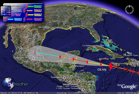
 "Fiercely powerful Hurricane Dean strafed Jamaica's southern coast on Sunday, littering the capital of Kingston with fallen trees and windblown roofs after killing six people earlier on its run through the Caribbean. Dean was an "extremely dangerous" Category 4 hurricane, the second-highest on the five-step Saffir-Simpson scale, and could become a potentially catastrophic Category 5 near Mexico's Yucatan Peninsula, the U.S. National Hurricane Center said.
Jamaica's government declared a 48-hour curfew and the power company switched off electricity as the wind began to howl and pounding waves battered the southern coast. Sheets of rain pelted Kingston and streets were blocked by toppled trees and utility poles. Dean ripped off several roofs and a man was missing after falling trees tore into his house. "The dead center of the eye is south of Jamaica by a few miles. But the center is close enough to Jamaica that they are likely getting hurricane-force winds along the southern coast," said Richard Knabb, a storm expert at the hurricane center. Mudslides were reported in several parts of the mountainous country of 3 million people.
Local media reported 17 fishermen and women had been stranded ahead of the storm on the Pedro Cays, a small island chain in the open sea about 50 miles (80 km) south of Kingston, directly in the path of the hurricane. They were told to break into a coast guard building for shelter but officials did not know if they had done that. The government had urged residents to go to shelters. But many people, including those in one low-lying seaport town close to Kingston, refused to flee. "We are going nowhere," Byron Thompson said in the former buccaneer town of Port Royal, settled by pirate Henry Morgan in the 16th century. "In fact, if you come by here later today you will see me drinking rum over in that bar with some friends." Earlier in the day, tempers flared in shops where Jamaicans scrambled to stock up on batteries, flashlights, canned tuna, rice and water. Campaigning for August 27 elections was halted."
Dean May Strengthen into a Category 5 Hurricane on Monday While Impacting Grand Cayman Island...Rough Surf and Rip Current Threat Increases in the Florida Panhandle Waters on Tuesday and Wednesday...Dean to Impact Mexico's Yucatan Peninsula on Tuesday...
Current Storm Position as of Aug 20 - 03:00 UTC Category 4 Hurricane, Maximum winds of 145 mph and a pressure of 924 mb, Latitude: 17.6/Longitude: -78.
![[Image of 5-day forecast of predicted track, and coastal areas under a warning or a watch]](http://www.nhc.noaa.gov/storm_graphics/AT04/refresh/AL0407W5_sm2+gif/024525W_sm.gif)
More images of Hurricane Dean can be found at Beau's Weather Blog
Hurricane History 1938
The New England Hurricane: New York, Connecticut, Rhode Island, Massachusetts, Vermont, September 1938
With weather radar and satellite technology ll, a hurricane brought the driving rain, battering salt spray and lethal winds of the tropics to landfall on Long Island, N.Y. The powerful storm overcame immense obstacles — cold water, east-moving ocean currents, sea-bound winds — to reach the dense, vulnerable northern cities and seashores, where it left catastrophe in its wake.
The New England Hurricane of 1938 started out as an unremarkable tropical depression just off the west coast of Africa, south of the Cape Verde Islands. It first caught the attention of weather forecasters in the United States as it passed north of Puerto Rico on Sept. 18 and 19 as a powerful Category 5 hurricane. But instead of pummeling directly into Florida, the hurricane skirted the Bahamas and banked north up the East Coast. Without weather radar and satellite technology, forecasters could only wait for news from ships caught in and near the storm. Finally, at 8:30 am on Sept. 21, a ship reported the hurricane just 100 to 150 miles off the coast of Cape Hatteras, N.C., 35 degrees north — an area considered the make-or-break point for New England-bound hurricanes. Usually, it's the break point: In 1938, it had been more than a century since such a powerful hurricane hit New England (in 1815). During normal summertime weather patterns, the east-flowing winds of the jet stream push impending northeast hurricanes out to sea. But on that September day, according to Harvey Thurm, hurricane program manager for the eastern region of the National Oceanic and Atmospheric Administration, reconstructed air maps suggest that the jet stream's flow bent southwards toward the Gulf of Mexico, and then blew northwards up the eastern seaboard. "Once the hurricane got caught up in that it was like a cork in a river's flow," Thurm says.
But even that would not have been enough to propel the storm up the coast. Warm water acts as fuel for hurricanes, and above Cape Hatteras, where the warm ocean currents of the Gulf Stream veer east, the water temperature begins to drop. "It's got to be a very powerful, very fast-moving hurricane to make it through the cold water," Thurm says. And it was: Traveling at 60 to 70 mph (twice as fast as many hurricanes), and aided by high-pressure systems to the east and west that formed a canal of low pressure, the hurricane muscled its way past Cape Hatteras, plowed through the cold water, and barreled into Long Island in just 6 hours.
Residents were caught off guard when, at 3:30 pm on the 21st, a hulking, foaming 16-ft. storm surge crashed ashore, spreading two-story-tall waves from central Long Island to Gloucester, Mass., about 250 miles apart. The surge enveloped shore towns, leaving standing water 6 ft. high and killing 29 in the small community of Westhampton, N.Y., alone. Survivors "grabbed onto telephone poles as boards, planks, and timbers pelted them," writes Everett Allen in A Wind to Shake the World. "The wind was southeast at well over 100 mph and the sand in the air was terrific." The troughs of towering waves left the bay floor dry, and the wind drove ducks backward in flight.
While the storm focused its force on the shore, waves littered the interior of Long Island with debris. The water tossed dozens of boats 300 ft. in from the coast, destroyed hundreds of houses, washed wreckage out to sea or deposited it inland, and scattered cars everywhere. The hurricane's relentless waves punched a hole through the beach at Shinnecock Bay, cutting it in two and creating Shinnecock Inlet, which still exists today. After devastating New York's coast, the hurricane's eye skipped across Long Island Sound and headed straight for Connecticut, Rhode Island and Massachusetts, hitting each with equal fury. Winds blew as high as 120 mph, mercilessly driving the storm surge into the shore. Continued...

In New London, Conn., at the mouth of the Thames River, the storm surge took the Marsala, a colossal 300-ft., five-masted cargo ship, along with its 8- and 10-ton anchors, and slammed it into the town's dockside warehouses, sparking a fire. Firefighters waded through chest-high floodwater to fight it for the next 10 hours. To the east, in Rhode Island, residents peered toward the ocean at what appeared to be a fast-moving fog bank. But when it drove closer, they realized, instead, that they were coming face-to-face with 40-ft. waves pushed by the storm surge. One hundred people were killed as the hurricane came ashore around Westerly and swept 500 homes into the sea.
The surge then worked its way north and west, funneling into Narragansett Bay and overwhelming the state's capital, Providence, at 4:45 pm — just a little over an hour past first landfall. Some Providence citizens retreated to the steps of the city hall as 14 ft. of water topped over vehicles, trolley cars and pedestrians. At the Biltmore, hotel guests hung knotted sheets out of their windows so that others caught in the flood below could grab them. At least 262 people were killed in Rhode Island, though in the 2003 book Sudden Sea: The Great Hurricane of 1938 author R.A. Scotti contends that the state's death toll was closer to 433. According to Scotti, plane crews performed the final tally by air, counting heads bobbing in the water.
The storm surge came ashore as far east as Cape Cod, Mass., where 8 ft. of water covered the resort town of Falmouth. Meanwhile, the eye of the hurricane headed straight up the Connecticut River and dropped up to 17 in. of rain as it pushed north toward Canada. The ground in western New England was already saturated from several days of rain, contributing to flood conditions. The Connecticut River rose 20 ft., burst its banks near the capital of Hartford and spread out 4 miles. Ninety-seven people died in Connecticut.
By 8 pm, not quite 12 hours after the hurricane passed Cape Hatteras, the storm mowed through interior Vermont, toppling tens of thousands of trees, and uprooting whole apple orchards in Burlington. In Montpelier, 50 miles south of the Canadian border, and 240 miles from Long Island Sound, the hurricane lashed houses with the salt spray it had picked up in the Atlantic Ocean. The hurricane crossed into Canada by 9 pm and faded away, leaving $6.2 million dollars in wreckage (or more than $15 billion in 2006 dollars) in its wake. In addition to killing nearly 700 people, the hurricane and the resultant flooding and storm surge injured 3500, left 63,000 homeless, damaged 75,000 buildings, and sunk 3000 boats as it came to shore. Continued...

The Aftermath
After more than a hundred years without a hurricane, the 1938 storm reminded northeasterners that they, too, are vulnerable to tropical-force destruction. And, because a storm must be incredibly fast and strong to reach New England, when a hurricane does come, it comes hard. Despite obstacles such as the jet and Gulf streams, five hurricanes have hit the northeast coast since 1938. The last one was Gloria, in 1985. Though none have connected with New York City, a direct, powerful hit could easily become the most catastrophic hurricane in U.S. history, based on the high population density and the difficulty of evacuating the island of Manhattan through the limited bridges and tunnels."It's a low-frequency event," says Thurm, who lives and works in Long Island. "But it would have a tremendously high impact. And it wouldn't take much of an adjustment in the upper air pattern to bring one right over New York Harbor." New Yorkers and East Coasters should know the basic National Weather Service nomenclature that is so familiar along the Gulf Coast. A hurricane "watch" is typically issued between 24 and 36 hours before a hurricane might hit, and means: Pay attention, something may be coming your way. A hurricane "warning" is more serious.
Issued roughly 24 hours before a hurricane might hit, it means: Get out of the way. It took decades for NOAA and the National Weather Service to create the technology that would allow them to predict the path of hurricanes and warn the vulnerable and unsuspecting — exactly what didn't occur in 1938. Primitive radars came on line in the 1950s, and the more sophisticated Doppler radar wasn't operational across the United States until the 1990s. Today, forecasters also use satellites and computer modeling to predict a hurricane's path and warn the public before it's too late.
To help the weather service make their hurricane predictions, NOAA also operates a small air force of planes that fly into, around and in front of hurricanes. "Besides the hurricane hunters that fly into the eye of the hurricane, there's a NOAA Gulfstream G-IV that flies at high altitude sampling the storm environment ahead of a hurricane," Thurm says. "For example, in the case of a hurricane headed for the northeast, they'd be looking to see if there's a southerly flow [northbound jet stream] present, and if so how strong is it, and which direction is it heading. It's a whole new world compared to 1938."
RS


![[Valid RSS]](valid-rss.png "Validate my RSS feed")