 The Madden-Julian oscillation
B. Geerts and M Wheeler 5/98
Discovery
In the tropics weather is not as predictable as in mid-latitudes. That is because in mid-latitudes the weather variables (clouds, precipitation, wind, temperature, and pressure) are largely governed by the upper-tropospheric Rossby waves, which interact with surface weather in a process called baroclinic instability (Note 13.B).
In the tropics there is no such dominant instability or wave motion, and therefore the weather is less predictable for the 1-10 day period. Until recently it was believed that tropical weather variations on time scales less than a year were essentially random.
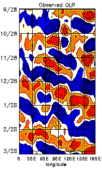
The MJO, also referred to as the 30-60 day or 40-50 day oscillation, turns out to be the main intra-annual fluctuation that explains weather variations in the tropics. The MJO affects the entire tropical troposphere but is most evident in the Indian and western Pacific Oceans. The MJO involves variations in wind, sea surface temperature (SST), cloudiness, and rainfall. Because most tropical rainfall is convective, and convective cloud tops are very cold (emitting little longwave radiation), the MJO is most obvious in the variation of outgoing longwave radiation (OLR), as measured by an infrared sensor on a satellite.
Figure 1 (from Elleman 1997) shows how the OLR anomalies in the eastern hemisphere propagate to the east at around 5 m/s. The OLR signal in the western hemisphere is weaker, and the recurrence interval for the eastward propagating OLR anomalies in the eastern hemisphere is about 30 to 60 days. How exactly the anomaly propagates from the dateline to Africa (i.e. through the western hemisphere) is not well understood. It appears that near the dateline a weak Kelvin wave propagates eastward and poleward at a speed exceeding 10 m/s.
Associated with the propagation of convective anomalies, the MJO involves variations in the global circulation. The MJO affects the intensity and break periods of the Asian and Australian monsoons and interacts with El Niño. Wet spells in the Australian monsoon occur about 40 days apart. Fairly weak correlations with the midlatitude rainfall patterns and jet stream characteristics have also been found (2).
In 1971 Roland Madden and Paul Julian (1) stumbled upon a 40-50 day oscillation when analysing zonal wind anomalies in the tropical Pacific. They used ten years of pressure records at Canton (at 2.8� S in the Pacific) and upper level winds at Singapore. The oscillation of surface and upper-level winds was remarkably clear in Singapore. Until the early 1980's little attention was paid to this oscillation, which became known as the Madden and Julian Oscillationnumber of MJO-related publications grew rapidly. (MJO), and some scientists questioned its global significance. Continuing reading
Speaking of surface weather and wave motion....
Nor'easter and Ice!
Brian A. Morganti of Storm Effects.com has some awesome shots from the snow storm that hit the Midwest including Chicago and merged with former Tropical Storm Olga now moving up the East Coast as a "Nor'easter" throwing a mixed bag including an ice storm in Berks County PA. (Click the Pix)

And
Steve Marshall is reporting that the same ice storm has fallen the WNEP tower in NE PA, which knocked out programming for a while.

Lastly
Bill Hark tells us that Storm Chaser Jim Reed will be on ABC Good Morning America on December 18 with Sam Champion, plugging his new book ...
by Jim Reed
| | | About This Book ISBN13: 9780810993921 |
RS


![[Valid RSS]](valid-rss.png "Validate my RSS feed")