Tuesday, September 4, 2007

A CAT 5 "Felix" Makes Landfall

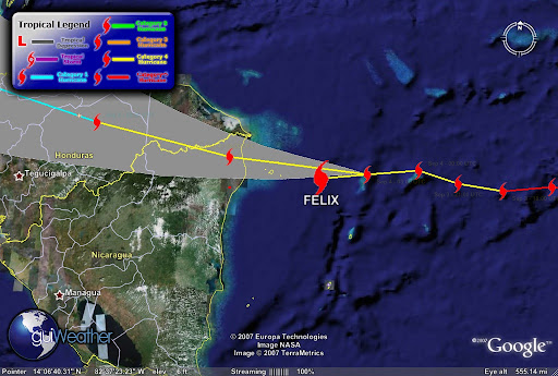
Hurricane Felix has made landfall in Northeast Nicaragua, northeast of Puerto Cabezas. Felix is now a Cat 5 storm.

Felix's current storm position as of
Sep 4 - 12:00 UTC is Latitude: 14.3
Longitude: -83.2 with maximum winds of 160 mph and a pressure of 935 mb.

During the morning hours Felix gained Category 5 strength from the warm Caribbean waters. This is a very powerful and dangerous storm.

Up to 40,000 Hondurans were evacuated to shelters but some 15,000 people were unable to find transportation and were forced to ride out the storm in their homes.
Its too early to report on any damage but we will be updating through out the day, so stay tuned.....


In the Pacific....

TS Henriette is now Hurrciane Henriette a Category 1 Hurricane with its outer bands approaching the southern tip of Baja California....

Henriette forecast storm position as of Sep 4 - 09:00 UTC was
Latitude: 21.4/ Longitude: -109.1
Maximum winds of 75 mph.


latest goes west infra red hurricane image


We will keep you posted!
RS

Felix Inbound Nicaragua UPDATED

This is an updated report.

Hurricane Felix a Category 4 and gaining strength. The storms current position as of
Sep 4 - 06:00 UTC is approximately 93 miles/ 80 nautical miles (Latitude: 14.3 Longitude: -81.9 off the Nicaragua coastline.

According to guiWeather track (see track below). The storms track indicates that the storm is currently deviating from its westerly track slightly to the south and if it maintains course will pass north of Pureto Cabezas on the Nicaragua coastline. The storm is packing maximum winds of 150 mph with a pressure of 940 mb.

Felix is moving toward the west near
20 MPH/32 KM/HR. A south westward track with some decrease in speed expected. The storm has strengthened and may further strengthen before landfall. Hurricane Force winds extend outward up to 35 miles and Tropical Storm Force winds extend outward to 195 miles.

This is a very dangerous storm. The deep ring of red in the satellite photo below indicate
intense thunderstorm or intense convection activity ongoing.


The track below also indicates that Felix is driving slightly south of it westerly track and will drive deep into Central America and we can expect
tropical torrential rains that can cause major flooding and mud slides in mountainous and low lying areas.


According to press reports," local officials pleaded with residents of Honduras, Nicaragua, Belize and Guatemala to evacuate low-lying areas especially Honduras’ nine offshore islands and otherwise prepare for inevitable disaster". Tourist have been evacuating resort areas jamming area airports.

On the Pacific side...

Tropical Storm Henriette is very close to becoming a hurricane. Henriette is tracking for tourist resorts in Baja California after killing seven people, five of them children, in Mexico's Pacific coastal state of Chiapas. Local Civil Protection Services reported that Henriette dumped torrential rains in Guerrero state on Friday, triggering a rockslide that buried six people in their homes in the resort city of Acapulco. Another man was killed when his vehicle was crushed under another rock slide in jungle ravine in neighboring Chiapas State.


TS Henriette current storm position as of Sep 3 - 18:00 UTC tracking North/Northwest at Latitude: 19.8 / Longitude: -108.3 with maximum winds of 060 knots with gusts to 075 knots.


Keep Posted!

RS