Thursday, January 31, 2008

UNDERSEA WEATHER

Undersea Weather

The extreme weather that impacts us is now having an effect where you might least expect it - deep under the sea. As this ScienCentral News video explains, scientists have linked climate change to population booms and busts in deep-sea life.

Not-So-Sunny Underwater Forecast

Warm waters might be soothing in a bathtub or a swimming pool but when the ocean heats up it can get mighty uncomfortable, and even deadly, not only for the animals who live there but for land lovers too. Peruvian and Ecuadorean fishermen even coined a term for the warm water phenomenon in the late 1800s, El Niño, their nickname for unusual Christmastime changes in water temperature that impacted their catch; El Niño has since been shown to cause extreme weather conditions like hurricanes and droughts.

Now scientists say that El Niño and La Niña - when ocean temperature in the Equatorial Pacific grows colder than normal compared to El Niño - are not only impacting life on land and on the sea surface, but also life on the ocean floor. Deep-sea ecologist Henry Ruhl, working with colleagues at Scripps Institution of Oceanography, reported in the journal Science that changes in surface ocean climate may be impacting animal populations far under the ocean

"The sea life populations were changing in a way that suggested that climate was linked to food supply, and food supply was linked to the abundance of the animals in the seafloor on time scales that were roughly similar to what we were finding in above-water systems," Ruhl explains. "So it seems plausible that climate could be affecting the deep sea relatively rapidly, and wasn't somehow far removed in time, even though it's out of sight, out of mind to many people." But he's quick to add that more research is needed to find the specific causes of the population jumps or declines he reported.

At "Station M," 130 miles off the California Coast, the Scripps team has been studying an abyss 13,400-feet deep since 1989. They set out to document something many agree they know little about - what happens deep beneath the sea. Using a submersible camera-mounted sled that snapped photos of ocean life every five seconds, researchers tracked ten mobile animal populations, including starfish and sea cucumbers. They took ocean floor samples of nutrient-packed sludge called sediment, a mix of feces and dead phytoplankton, amongst other things, that sinks from the sea surface and provides food to animals on the seafloor. Then, the team compared sediment composition to changes in time and weather.

The information gave Ruhl a more complete picture of how deep-sea marine animals may be impacted by climate change. "We believe that food supply is one of the only plausible mechanisms for the climate to be affecting the animals on the seafloor," he says. "And we believe it's happening through a mechanism in which climate affects the productivity or the amount of sea life above the study site on the overlying surface waters."

El Nino Satelite
Satelite imaging of climate changes and ocean temperatures produced by El Nino.
image: NOAA
It's there that phytoplankton float on the ocean surface, where they grow by soaking up the sun and taking in nutrients like iron. The problem is that phytoplankton is also highly sensitive to a domino effect brought on by climate changes. During an El Niño event, wind patterns and ocean circulation change. One result is a slowdown in something called upwelling, the upward flow of cold, heavy, deep-sea water resulting when off shore currents draw warm surface water away from the coast. Upwelling floods ocean surface water with nutrients. But when this nutrient rich water fails to reach areas where phytoplankton live, as happens during an El Niño event, phytoplankton slowly starve. In turn, other sea life that depend on phytoplankton as a food source start dying too. Ruhl believes that these kinds of changes in sea surface life directly "affects the population of the animals in the sea floor."

Experts say scientists are getting better at spotting El Niño events ahead of time, even though solutions to the problem, and the subsequent impact it has on sea life, aren't so forthcoming. The National Oceanographic and Atmospheric Administration (NOAA) is one agency that tracks El Niño. Scientists there were able to predict the 1997-1998 El Niño six months ahead of its arrival, using instrumentation like satellites and ocean buoy data. Their predictions saved California over a billion dollars since the state was able to prepare for the event ahead of time.

So, should we be putting the sea cucumber up there with other endangered species? Not yet. Ruhl says that what we do with the information uncovered in the study is "really a values question...not in our lifetime will we be affected by what happens in the deep sea, other than knowing that it's happening."

It's in a hundred years or more that people will have to fish for solutions to much bigger problems down below.

MARITIME NOTES

IMO – International Ice Patrol

The IMO issued a circular forwarding a communication from the Government of the United States concerning International Ice Patrol (IIP) services for 2008. SN.1/Circ.268 (1/22/08).

ON THIS DAY IN HISTORY - THE PRINCESS VICTORIA DISASTER

"1953, Irish Sea: 130 die in ferry disaster. The inquiry concluded the ferry owners were to blame for the poor design of the stern doors which were torn open in the heavy seas. The highest civilian award for bravery, the George Cross, was given posthumously to the ferry’s radio operator, David Broadfoot, who remained at his post sending out messages for assistance until the ship sank. The captain went down with his ship."

BBC, 1953: A car ferry has sunk in the Irish Sea in one of the worst gales in living memory claiming the lives of more than 130 passengers and crew.

1


THE IRISH SEA

The Princess Victoria, a British Railways car ferry, bound for Larne in Northern Ireland, had left Stranraer on the south-west coast of Scotland an hour before when the stern gates to the car deck were forced open in heavy seas.

Water flooded into the ship and as the cargo shifted, the ferry, one of the first of the roll on-roll off design, fell onto her side and within four hours she sank. Among the passengers who perished were the Northern Ireland Finance Minister and Deputy Prime Minister Major J M Sinclair, and Sir Walter Smiles, the Ulster Unionist MP for North Down.

The Northern Ireland Prime Minister, Lord Basil Brookeborough, paid this tribute: “The waves that yesterday were mountainous are relatively calm again but they’ve become the tomb of 130 of our fellow citizens. Under this cruel stroke of fate, many families are sorrowing today, they have the heartfelt sympathy of us all.”

Captain radioed for help

Tragedy struck at 0845 GMT when Captain James Ferguson radioed the coastguard to say the ferry was “not under command and needed a tug”.

At 1252 the captain radioed to say the engine room was flooded and he had decided to abandon ship.

Later messages made clear that the ship was listing so much that it was impossible to launch the lifeboats.

One lifeboat was smashed against the ship’s side. Another, containing eight women and a child, was swamped by huge waves and sank.

RAF planes were alerted to the sinking at about 1500. They arrived at the scene half-an-hour later and dropped rubber dinghies but blinding squalls of sleet and rain hampered their efforts.

One of the lifeboatmen sent to the rescue said they spent two hours searching for survivors. One man was found clinging to a raft on which were four other people who had died from exposure.

The first survivors, including Petty Officer Jay Yeomans, were landed at Donaghadee, 20 miles east of Belfast.

Fusilier Jeoffrey Bingley was another survivor. “I didn’t expect to be alive… I was in the lower deck when the boat started to go over and I scrambled down the side of it and got into a lifeboat,” he said.

“We pushed away with about 20 on board and managed to pick a few up out of the sea. We didn’t have any oars - the sea just took its course.”

AROUND THE WORLD BY - Arthur Rabjohn CEM

CANADA: Emergency team rolls out as ice storm knocks out power to 70000. The Red Cross activated its emergency response team Wednesday after two days of freezing rain brought down power lines across Prince Edward Island, knocking out electricity to much of the province. The blackouts started Tuesday afternoon in western P.E.I. and spread eastward, with Charlottetown losing power for about three hours on Wednesday afternoon. At one point, about 70,000 residents were without electricity, including those in some communities in eastern P.E.I. As night fell, officials with Maritime Electric said service would be fully restored by Friday at the latest. Reports from the western end of the Island suggested the ice storm had caused extensive damage to the power grid. Amid toppled utility poles and ice-laden power lines, heavy fog had reduced visibility to mere metres for crews scouting for problems by snowmobile.

MALAWI: Rising floodwaters devastating the crops, livestock and infrastructure across half the coutry and menacing more than 73,000 Malawians are going to get worse, government officials said Wednesday. "It's getting worse in Malawi because it is raining everyday," said Lilian Ng'oma, a senior official in the disaster management ministry. "We expect more rains and more flooding this year".

CHINA: China's worst snowfall in decades may have a serious impact on crop production in the south of the country. The snowstorms have affected nearly 80 million people across 14 provinces. At least 38 people had been killed in snow-related accidents such as house collapses and falls. People are already experiencing shortages of food. More than a dozen provinces have also been hit by blackouts due to missed coal deliveries for power stations and rising demand amid the cold. At least 12 national highways remain blocked. Forecasters are warning of more snow and urging people not to travel.

INDONESIA: A 5.9-magnitude aftershock has rocked an eastern Indonesian province, one day after a 6.6-magnitude quake prompted a brief tsunami alert. The aftershock struck earlier today and was located 248 km northwest of Saumlaki town in Maluku province. There was no risk of a tsunami.

KYRGYZSTAN: Over half of the 5,000 people, who have been made homeless by an earthquake which struck southern Kyrgyzstan on 1 January, are still living in tents and trying to survive harsh wintry conditions. The affected people have received initial relief items, such as winterised tents, heaters, electricity transformers, and coal. This included assistance provided by the MIC. Many villagers are running low and they need more fuel to keep them warm in the extreme cold.

VANUATU: Tropical cyclone Gene struck Vanuatu, bringing 1-minute maximum sustained winds to the region of around 157 km/h. The potential property damage and flooding from a cyclone includes: storm surge generally 1.8-2.4 m above normal, minor damage of buildings, considerable damage to shrubbery and trees, coastal and low-lying escape routes flood 2-4 hours before arrival of the storm center. There is also the potential for flooding further inland due to heavy rain.

CHICAGO WEATHER

WINTER STORM WARNING IN EFFECT FROM 6 PM CST /7 PM EST/ THIS EVENING TO 6 PM CST /7 PM EST/ FRIDAY
Issued: Thursday, January 31, 2008 4:28 AM CST
Expires: Thursday, January 31, 2008 12:30 PM CST

Urgent - Winter Weather Message National Weather Service Chicago/Romeoville IL 428 AM CST Thu Jan 31 2008

...Intensifying Winter Storm Expected To Impact The Area Tonight Into Friday...

.An Area Of Low Pressure Currently Developing Over The Southern Plains Will Continue To Intensity Today...And Will Move Into Southeast Indiana By Friday Morning...And Into The Eastern Great Lakes On Friday. Snow Will Overspread Northern Illinois And Northwest Indiana Late This Afternoon Into Early This Evening With A Potential For Heavy Snow Tonight Into Early Friday Morning.

Dupage-Cook-Grundy-Will-Kankakee-Livingston-Iroquois-Ford- Lake Indiana-Porter-Newton-Jasper-Benton- Including The Cities Of...Chicago...Morris...Joliet...Kankakee... Pontiac...Watseka...Paxton...Gary...Valparaiso...Morocco... Rensselaer...Fowler 7 PM Est/ This Evening To 6 PM CST /7 PM Est/ Friday...

The National Weather Service IN Chicago Has Issued A Winter Storm Warning...Which Is IN Effect From 6 PM CST /7 PM Est/ This Evening To 6 PM CST /7 PM Est/ Friday. The Winter Storm Watch Is No Longer IN Effect.

Light Snow Will Develop Across The Area This Afternoon...But Little Or No Snow Accumulation Is Expected. Snow Will Increase IN Coverage And Intensity By This Evening As A Strengthening Storm System Across The Southern Plains Begins To Track Northeast. Heavy Snow Will Be Possible From This Evening Through Friday Morning...And Then Will Taper To Light Snow And Flurries Friday Afternoon. Storm Total Snowfall Accumulations Will Range From 5 To 7 Inches From Evanston To Morris To Pontiac To 7 To 11 Inches From Gibson City To Fowler Indiana Where Locally Higher Amounts Closer To A Foot Are Possible.

Additionally...East To Northeast Winds Will Be Increasing During The Period Leading To Blowing And Drifting Snow. The Rush Hour Commute Friday Morning Will Be Adversely Affected By These Conditions As Many Roads By Morning Will Be Slick And Hazardous. Snow Will Gradually Begin Tapering Off To Flurries By Friday Afternoon As The System Exits Towards The Northeast.

A Winter Storm Warning Means Significant Amounts Of Snow... Sleet...And Ice Are Expected Or Occurring. Strong Winds Are Also Possible. This Will Make Travel Very Hazardous Or Impossible.

RS

Wednesday, January 30, 2008

JANUARY 2008 INDIANA TORNADOES ? UPDATED

UPDATE 0833hrs, 30 Jan 08!

Midwest braces for 'vicious slap from Mother Nature'

CHICAGO -- Severe thunderstorms, tornadoes and fierce winds sliced through the Midwest, leaving behind bitterly cold air and blizzards in the northern Plains that sent temperatures in some areas plummeting by 50 degrees in a few hours.

Forecasters warned more bad weather was on the way Wednesday.

"This is going to be a hard, vicious slap in the face from Mother Nature," Gino Izzi, a meteorologist with the National Weather Service in Romeoville, Illinois, said Tuesday night. "The temperature drop we saw was really spectacular in a bad way."

High winds associated with thunderstorms may have killed two people in Indiana, authorities said Tuesday. Snow forced the closure of schools and highways in many areas, and avalanche warnings were issued for some Western regions.

"I wouldn't call it a common occurrence to see winds this strong with this kind of snow," Izzi said. "This isn't something we see every year."

The cold air and wind gusts as high as 70 mph slammed into the Midwest, where fog created problems for air travel Tuesday in Chicago. About 350 flights were canceled Tuesday at O'Hare International Airport, said Chicago Department of Aviation spokesman Karen Pride.

The system also dragged frigid air across the northern Plains. The Weather Service reported a midday temperature of 24 degrees below zero at Glasgow, Montana. North Dakota registered wind chill factors of 54 below zero at Garrison, while Williston hit a low of 24 below.

Most of Minnesota was under wind chill warnings until noon Wednesday due to indexes that fell into the minus 30 degree level. It was as low as 50 degrees below freezing in Hibbing.

Though only light snow fell in western, central and eastern Iowa on Tuesday, winds snapping as fast as 60 mph caused visibility problems, and temperatures dropped into single digits.

In north central and eastern Iowa, forecasters expected strong winds and blowing snow to continue overnight, and for temperatures to possibly dip to 10 below zero.

"It's a little worse than your average snowstorm," said Rod Donovan, a meteorologist with the National Weather Service in Des Moines, Iowa. "The biggest impact is that the driving conditions can change quickly with this type of storm. Once it begins, travel is quite hazardous."

Some 1,500 workers went home early from the Mayo Clinic in Rochester, Minnesota, while critical medical staff were put up in hotels so they could stay close to serve patients. The blustery winds also put flight operations on ice at the Rochester airport.

Firefighters in southwestern Indiana pulled two bodies from a mobile home near Evansville that had been turned on its side by winds in a thunderstorm, WEHT-TV reported.

Residents near Danville, west of Indianapolis, reported funnel clouds, and damage was reported to a home and the Morgan County Courthouse in Martinsville.

The National Weather Service reported an unconfirmed tornado touchdown near Okawville, Illinois. A corner of the roof peeled off a high school in Nashville, Illinonis, but no injuries were reported.

Temperatures in Illinois dropped from Tuesday's highs in the 40s to about zero overnight. In anticipation, some central Illinois schools canceled Wednesday classes.

In Cape Girardeau County, Missouri, winds as strong as 70 mph and dime-size hail were reported Tuesday. Two unconfirmed funnel clouds were reported, said Dick Knaup, the county's emergency management director.

The week began with heavy snow pummeling mountain areas from Washington state to northern Arizona as two storms converged, one from hard-hit California and another from the Gulf of Alaska, meteorologists said. VideoWatch residents struggle in Spokane, Washington »

The storms were followed Tuesday by a third that threatened to leave up to 20 inches of snow in Idaho's mountains, said Jay Breidenbach of the Weather Service office in Boise, Idaho.

A fourth storm was on the way to the interior West: "By Thursday, the next storm will be right on our doorstep. This is quite a storm system," Breidenbach said.

The Navajo reservation, which sprawls across parts of Arizona, Utah and New Mexico, was under an emergency declaration because of the possibility that melting snow could create flooding.

In the snow farther west, avalanche danger forced officials to close Interstate 90 at Snoqualmie Pass, Washington state's main east-west artery across the Cascade Mountains. The pass was to remain closed until Wednesday morning, Meagan McFadden of the state Department of Transportation said.

More than 200 trucks were backed up at North Bend, waiting to move freight across the pass. On a typical weekday, as many as 7,000 trucks travel I-90 over Snoqualmie Pass, she added.

Snow also closed highways in Minnesota, Colorado and Wyoming.

Two of three snowmobilers lost in the mountains west of Denver were found late Tuesday, said Summit County sheriff's spokeswoman Paulette Horr. The third was still missing.

In Oregon, two snowmobilers were rescued Monday after spending two nights in the Wallowa Mountains, where they were trapped by storms. Authorities said the two were dressed warmly and equipped with survival gear, matches and an avalanche beacon.

Copyright 2008 The Associated Press. All rights reserved.10:17

PM January 29, 2008


Tornadoes reported in metro area; 2 dead in S. Ind.
January 29, 2008

Several tornadoes were reported in the Indianapolis-metro area tonight as high winds, hail and thunderstorms moved across Central Indiana. Officials said that two deaths in southern Indiana may have been caused by high winds.

Firefighters pulled two bodies from a mobile home in northern Posey County after it was turned over on its side, apparently by storm winds, Evansville television station WEHT reported.

A sheriff’s dispatcher said he could not confirm the deaths but said the coroner had been called to the scene.

Duke Energy reported more than 28,000 customers without power as of 9:25 p.m., with the largest outages in Morgan and Vigo counties. More than 6,600 people were without power in Morgan County, while power to more than 5,000 was cut in the Terre Haute area.

WEHT reported that Pike County and South Gibson school districts canceled classes Wednesday due to power outages.

There were preliminary reports of storm damage on the Northwestside of Indianapolis as the leading edge of the storm reached the city. From Bloomington to the south and Frankfort to the north, the storm blew through with winds of more than 60 mph, according to the National Weather Service in Indianapolis.

Reports of downed power lines, damaged roofs and toppled trees followed the storm as it moved through the area. There were preliminary reports of damaged homes in eastern Hendricks County.

At 7:18 p.m., northern Marion County came under a tornado warning with a preliminary report of a tornado touchdown in Clermont, along the Hendricks County line. Such reports are typically confirmed by the weather service the next day after a visual inspection.

A tornado warning was issued for Fillmore, Ind., 26 miles south of Crawfordsville, at 6:44 p.m. National Weather Service radar showed a possible tornado near Danville at 6:57 p.m. today.
IPL was still getting reports of power outages immediately after the storm, but the utility's first estimate was that 8,500 customers lost power, mostly on the Northwestside, said Crystal Livers-Powers, spokeswoman for IPL.

Firefighters were looking into reports that several homes were damaged on Swanson Drive on the Northwestside, not far from 44th Street and Kessler Boulevard North Drive.
Downed lines and debris led to the brief closing of the intersection of 30th Street and High School Road.
The wind and rain were only the beginning, weather experts said.

Tonight, a cold front is expected to settle in, pushing temperatures below freezing — possibly into the upper 20s — between 10 p.m. and 11 p.m., said Jason Puma of the weather service.

The overnight low for Indianapolis was forecast to be 11 degrees, officials said.

“That’s a big change considering we’re about 50 degrees right now,” Puma said about 6 p.m. today.

Tomorrow is supposed to be cold and dry, with highs in the 20s, but things could get interesting later in the week, he said.

“We could see a significant winter storm … (one that is) building out of the southern plains,” Puma said. “Given what we’re seeing so far, it will be a measurable snowfall."

NWS Indianapolis Reports - Severe Thunderstorms batter Central Indiana


ILLINOIS CHASE REPORT

January 29, 2008 Southwest Illinois Chase
by John Farley

Yes, really! A chase in January! And a very interesting weather day indeed. I had no real plans to chase today, but did keep up with the weather situation and when, by shortly after noon, it became apparent that severe weather could occur in my immediate area, I decided to head out. With marginal instability (it IS January, after all) but very strong low-level shear and a very strong cold front approaching, SPC had placed much of eastern MO and southern IL under a tornado watch. Scattered storms were developing between the STL area and the front, which was located near Columbia, MO around noon. (Report)

WISCONSIN TORNADO UPDATE

Odyssey of family's checks shows human concern, tornado's power

Posted: Jan. 17, 2008


Jim Stingl
E-MAIL

Christopher Bilda's first thought when he found a pad of checks on his property in Waterford was that maybe he had a trespasser.

"I was just walking my dogs. I've got a 7-acre place. There it was in the middle of the woods," he said.

It wasn't a whole checkbook, just a pad of checks about half used up. They were soggy but readable.

John Nichols is the name on the checks. Beaverton Road. Capron, Ill.

Christopher's wife, Cindy, told him there had been tornadoes in northern Illinois the same day last week that Kenosha County got hit. Maybe the checks blew up here.

But Capron to Waterford is more than 40 miles, a long way to ride on the wind.

Christopher contacted me to see if we could track down John Nichols and figure out what happened. I did a Google search for Nichols-Beaverton-tornado. Up popped the answer.

"Many working to help tornado victims," one site was headlined. "It's a total disaster," another said.

Reading further, I learned that the person most seriously hurt was Jeanette Nichols, 64, from the same Beaverton Road address on the checks. She had broken bones and a punctured lung. Her son, John, and two of his children had survived more or less unhurt.

The house was leveled. Same with a garage, pole barn and chicken coop.

Jeanette answered the phone when I called her room at St. Anthony Medical Center in Rockford. "They tell me I'm healing. They got me out of intensive care," she said.

She and her family never heard any warning siren, she said.

The tornado was suddenly on top of them. John had been helping his kids with their homework and managed to rush to the basement with them as the house was disappearing above them. Jeanette was in a different room.

"The glass broke and the wind blew me out the window and dropped me," she said.

Christopher Bilda knows something about surviving disaster. He's a machinist at Falk Corp., and he was there when the plant was rocked by a huge explosion in December of 2006. He remembers shattered glass, debris and smoke.

The checks he found on his property, and the powerful act of nature that carried them there, have left an impression on Christopher. "I hope it never happens to me. Imagine your stuff scattered all over," he said.

When I reached John Nichols, he said he was astounded that his property was discovered so far away. He said the checks had been sitting on his desk in a second-floor bedroom. The desk was never found.

"It was nice he called," he said of Christopher's quest to find the checks' owner. "That's the only thing I know of that came back to me like that."

The Nichols family lost most of its possessions in what John calls those "15 seconds of terror." But John's and Jeanette's wallets were both found in the rubble, at least some irreplaceable photos were recovered, and two plates once owned by Jeanette's grandmother survived the storm unbroken. Volunteers have come by the hundreds to help out.

Christopher planned to mail the checks back to John. They are a grim souvenir of this rare January tornado, but also a small reminder that we're looking out for one another.

Call Jim Stingl at (414) 224-2017 or e-mail at jstingl@journalsentinel.com


SUMMER FLOODS OF 2007 IN THE UK

The Association of British Insurers (ABI) has released its report into the Summer Floods of 2007 in the UK. It can be found at: SUMMER FLOODS OF 2007 IN THE UK


WORKSHOPS

NATIONAL SEVERE WEATHER WORKSHOP 2008

A national forum for academia, emergency management, media, and NOAA to exchange information and techniques for public safety during severe weather.
March 6-8, 2008. National Center for Employee Development 2801 East State Highway 9 Norman, Oklahoma 73071

INDIANA SEVERE WEATHER SYMPOSIUM


CISWS Logo

CHICAGO WEATHER

50 degrees today... that came to an sudden end! Like in three hours...


RS

Monday, January 28, 2008

NOAA Selects Bill Read as New National Hurricane Center Director

He is smiling now! Hope it stays that way! Good Luck Bill Read!

January 25, 2008

(Bill Read at the National Hurricane Center forecast desk.)

+ High Resolution (Credit: NOAA)

NOAA officials today named Bill Read as the new director of its Tropical Prediction Center, which includes the National Hurricane Center and two other divisions, in Miami. Read has served as the center’s acting deputy director since August 2007.

“Bill has what it takes be the nation’s hurricane center director. He’s spent 30 years of his career as a weather professional with NOAA dedicated to protecting lives from severe weather, much of it hurricanes and tropical storms,” said retired Navy Vice Admiral Conrad C. Lautenbacher, Ph.D., under secretary of commerce for oceans and atmosphere and NOAA administrator. “Bill has been a trusted consultant to emergency managers in and around Houston and I’m sure he will foster that type of goodwill in communities vulnerable to hurricanes. He will find the job as rewarding as it is demanding.”

Tropical storms and hurricanes have frequently played a major role in Read’s professional life. Read and his team were at the forefront in July 2003 as Hurricane Claudette made landfall on the Texas coast. He also was part of the Hurricane Liaison Team at the National Hurricane Center in Miami when Hurricane Isabel came ashore on the Outer Banks of North Carolina and raced northeast in September 2003.

Read was appointed to direct the Houston/Galveston weather forecast office of NOAA’s National Weather Service in 1992 and led it through the challenges of the National Weather Service modernization and restructuring program in the mid 1990s.

“Bill brings a wealth of experience in meteorology and management to this position. He has a clear understanding of the needs of staff, the emergency management community and the public in fulfilling our mission of saving lives and property,” said Jack Hayes, director of NOAA’s National Weather Service. “Bill has a proven track record of pulling people together – from the forecaster to the emergency manager – as severe weather threatens.”

Prior to joining NOAA’s National Weather Service, Read served in the U.S. Navy, where his duties included an assignment as an on-board meteorologist with the Hurricane Hunters. He began his career in 1977 with the National Weather Service test and evaluation division in Sterling, Va., developed his forecasting skills in Fort Worth and San Antonio, Texas; and, served as severe thunderstorm and flash flood program leader at the National Weather Service headquarters in Silver Spring, Md.

NOAA’s Tropical Prediction Center contains three divisions – 1.) the National Hurricane Center provides forecasts of the movement and strength of tropical weather systems and issues watches and warnings for the U.S. and surrounding areas, 2.) the Tropical Analysis and Forecast Branch provides support for satellite and radar analyses, and 3.) the Technical Support Branch provides support for the Center’s computer and communications systems and develops new techniques for tropical cyclone and tropical weather analysis and prediction.

The National Oceanic and Atmospheric Administration, an agency of the U.S. Commerce Department, is dedicated to enhancing economic security and national safety through the prediction and research of weather and climate-related events and information service delivery for transportation, and by providing environmental stewardship of our nation's coastal and marine resources. Through the emerging Global Earth Observation System of Systems (GEOSS), NOAA is working with its federal partners, more than 70 countries and the European Commission to develop a global monitoring network that is as integrated as the planet it observes, predicts and protects.

ILLINOIS TORNADO TALLY 2007 - a Quiet Year

The tornado statistics for Illinois for 2007 are as follows:

JAN 0
FEB 0
MAR 4
APR 2
MAY 5
JUN 4
JUL 0
AUG 2
SEP 4
OCT
2
NOV 0
DEC 0
TOTAL 23

By EF Scale
EF0 22
EF1 1
EF2 - EF5 0

Total by NWS office area of responsibility
Chicago (northeast/north central IL) 5
Quad Cities (northwest IL) 3
Lincoln (central/southeast IL) 6
St. Louis (southwest IL) 7
Paducah (southern IL) 2

The 30 year running annual average for the state of IL from 1978-2007 is 41.

NWS CHIGAGO/ROMEOVILLE - Looking for River Watchers

River Watchers Wanted

The National Weather Service (NWS) in Chicago/Romeoville, IL is looking for individuals that live or work along the Kankakee River to become part of a river watcher network. Ice jams can result in rapid and devastating flooding. Although the NWS does monitor a small number of automated river gages, they typically do not accurately reflect the current conditions upstream and downstream due to the isolated nature of ice jams. It is also important to know extent of the current ice cover and conditions. That kind of information can only be obtained from visual observations. Under no circumstances are river watchers to actually go out on the ice! Your safety is important to us. Observations should be made from a safe location on the bank or perhaps from your home.

River watchers will receive basic training that will cover ice formation and ice reporting procedures. We hope to expand the network to other rivers in northern Illinois prone to ice jam flooding including the Rock and Fox Rivers.

If you are interested please contact Bill Morris, Hydrologist at the National Weather Service Chicago/Romeoville office. Please include your name, address, phone number, and email.


211 WEATHER CENTER

State Unveils 211 Storm Emergency Number

New Number Aims To Reduce Calls To 911

BOSTON --
There's a new phone number to call during storms or disasters in Massachusetts: 211. Officials at the Massachusetts Emergency Management Agency said 211 is designed to reduce the number of non-emergency calls made to 911.

By dialing 211, people can get updated disaster information and post-disaster programs, as well as volunteering and donation opportunities. The 211 call center operates weekdays 8 a.m. to 8 p.m., providing information about social services. It can be staffed around the clock during emergencies. The state is operating the 211 system with the Council of Massachusetts United Ways.


TORNADO WARNINGS
From Journal Sentinel readers
Jan. 26, 2008

Use phones to create a better system for severe weather emergency warnings

We live in the Town of Dacada, east of Random Lake. There are no sirens in our area, and back in 1996, we had a "tornado." It was called "straight-line winds," and we lost our 40-by-70-foot barn, and a cow was killed when the barn went down.

Earlier that night, the storm was in the Dakotas, and then it went through Minnesota and east into Wisconsin. It hit the Random Lake region around 2 a.m.when everyone was asleep. Thirteen barns went down that night.

Our answer to the problem of an audible warning siren is to set up a system that will warn people who are sleeping or out of earshot of sirens. The phone company could set up a system to send 15 fast rings, awakening residents to alert them to the approaching danger. Residents then could turn on the radio or television to find out what they should do.

This system also could be used during the daylight hours to alert the elderly who might not have the radio or television on. Neighbors without phones could be warned by their neighbors, and even cell phones could be notified. This should solve the problem without the huge expense of a siren system.

Jerry and Kathy Daddato
Dacada

TYPHOONS 2007

NW Pacific Typhoons 2007 Summary of 2007 NW Pacific Typhoon Season and Verification of Authors' Seasonal Forecasts. Published 9th January 2008

MARITIME NOTES FROM HOLLAND AND KNIGHT

New York – freshly squeezed

The US Coast Guard issued a press release stating that, on January 24, the orange-juice tanker ORANGE SUN collided with the dredge NEW YORK in Newark Bay. The US Coast Guard also issued a video release which you may find interesting. No injuries were reported. The incident is under investigation. A subsequent press release reports on steps take to minimize the impact of the hydraulic fluid that was released into the water and the initial survey of the damaged dredge. (1/26/08).

USCG – ISPR report to be released

The US Coast Guard issued a press release stating that the Incident Specific Preparedness Review (ISPR) Phase I report will be released in San Francisco at 1:00 p.m. local time on Monday, January 28. The report concerns the first two weeks of the response operation to the COSCO BUSAN oil spill. It does not address the cause of the spill, only the preparedness for and response to the spill. A second report on the remainder of the response will be released at a later time. (1/25/08).

San Francisco Bay – update n COSCO BUSAN clean-up

The Unified Command issued a news release providing an update on the clean-up of the oil spill from the COSCO BUSAN. Reading between the lines, it appears that the active response is largely complete. (1/24/08).


RS

Friday, January 25, 2008

Waterspouts and Ships!

Waterspouts are one of the subjects that we have yet covered.

So since I received the below email from a good friend of mine, who is serving as a Chief Mate aboard a "Drill Ship" doing exploration off the coast of South America. (No the report did not come from this vessel I linked to either).

So what is a Chief Mate aboard a commercial ship? Well he is next in command to the Master or Captain. For you Star Trek fans this would be equivalent to Mr. Spock...

So I thought we would visit the subject. Remember when aboard ship there is really no place to run!

(To the left is a drawing by Benjamin Franklin and his understanding of water spouts.

Benjamin Franklin was a student of severe weather and theorized about how storms formed. Representation of waterspout accompanying "Water-spouts and Whirlwinds" by Benjamin Franklin.

This paper was republished in "The complete works in philosophy, politics, and morals, of the late Dr. Benjamin Franklin ....", 1806. Volume II, p. 26. Library Call Number PS745 .A2 1806. Image ID: wea00342, Historic NWS Collection)

As my shipmate writes....

"At around 9:45 on Wednesday 16 Jan we were drilling and sitting in 40knot winds from direction 145... A ABS (Able Body Seaman) ran into the operations office and said he spotted a waterspout. Operations opened the door and said there was zero visibility. A couple minutes later we got hit with a steady 85 knots on the stbd beam, gust up to who knows what. All 6 7,000hp thrusters kicked in but we were still pushed off 35 feet."

Its not all that uncommon for ships to get struck by a waterspout since its really hard to sail around them and especially when watches and warning at sea are almost non-existent. Yes the ship will get weather briefs or weather faxes with potential dangers, but unlike a shore-based tornadoes there is no news flashes, warning sirens, news helicopters daring the twister or storm chasers and spotters sounding the alert. As he writes, most of these events are spotted by the crew and by that time ... well... as you can read it is sometimes too late.

In this case there was no injuries and damage was very limited. But as you can read this water spout actually move the ship off station by 35 feet. Now that might not sound like a lot but on many ships and especially offshore platforms like a drill ship, have a computer control system called a "Dynamic Positioning System" which keeps the ship stabilized and on course or on station. Its like a very advanced cruise control for ships.

Though there were two reported, now funny events (they were not at the time). Seems as the waterspout dropped in for a visit there was one seaman at the time working on the derrick of this drill ship and supposedly you now can see his finger nail marks on the hand rails! One lucky dude! The second one though some of you might laugh, but seafarers do take superstition seriously even today. It involved a visiting technical representative who came onto the bridge whistling just prior to the ship being struck by the waterspout. This person was asked to stop whistling and replied something to the effect that they were not superstitious.

Well you see, according to maritime lore, whistling "on-board" ship brings winds... Moments later the ship was struck by the waterspout along with 85 knots+ winds....Think that person is now superstitious?

So what is a "Waterspout"?

Waterspouts are tornadoes over water. But scientific work over the last 30 or so years has led to a more complicated picture with waterspouts differing in some ways from tornadoes over land, especially large ones.

Waterspouts and all the different kinds of tornadoes have a similar basic structure with air moving upward. At the ground or ocean surface, winds are rushing faster and faster as they swirl into the vortex and then upward.

Often with both tornadoes and waterspouts, the vortex is seen coming down from the cloud, but not obviously touching the ground or ocean. Such vortices that don't seem to touch the ground are called "funnels" or "funnel clouds."

It's important to say "seems" not to touch because often, especially in the beginning, the vortex is invisible along part of its path. We begin to see the vortex when its lower air pressure cools the air enough to condense water vapor in the air into tiny water droplets.

Beginning in the late 1960s when he investigated waterspouts in the Keys from a single-engine Cessna 172 piloted by a friend, Joseph Golden, now a senior scientist at the National Oceanic and Atmospheric Administration, documented the "what" of spouts and tried to puzzle out the "why." The original studies were for his Ph.D. thesis at Florida State University.

During 12 days in September 1974, Golden flew into 16 Florida Keys waterspouts — one of them 26 times — in a North American T-6 airplane that had been modified for weather research. The World War II era trainer was flown by a professional weather research pilot. Golden recalls that flying into spouts with winds blowing faster than 60 mph around the vortex and moving upwards at 20 mph or better "rattled my teeth."

And, he notes, these were "weak to moderate" strength waterspouts. Careful study of movies or videos of waterspouts show speeds up to the 190 mph range.

They are not to be taken lightly.

In fact, Golden speculates that "a significant fraction of the so-called Bermuda Triangle incidents are from waterspouts."

How waterspouts form

The first sign, which can be seen from the air but usually not from a boat, is the formation of a dark spot on the ocean. Smoke flares dropped in these areas show the air is moving in a circle and upward. Many dark spots die out without progressing any further. But some begin to take on a spiral pattern of dark and lighter water.

Golden says at this second stage someone on a boat at the surface would probably feel the wind shift and maybe increase. Also, if you looked upward, you might see a funnel coming from a cloud overhead or off to one side.

People on boats will see the third stage.

Even though it might be invisible, a vortex is reaching the ocean surface from the cloud. When the wind speeds reach around 40 mph, the wind begins to kick up spray in a circular pattern — the spray vortex. At this time you might see the funnel pointing down from the cloud toward the ring.

The fourth, or mature, stage is when the funnel reaches all the way from the cloud to the ocean. You can usually see through the funnel - it's really a thin cloud of tiny water droplets.

During this stage, small waves are being kicked up and the spout leaves a bubbly wake behind as it moves across the ocean. These tiny bubbles could be carbon dioxide and other gases that are dissolved in the water that are caused to effervesce by the low air pressure in the spout's center - like a bottle of soda that's just opened.

In the fifth, and final stage, the spray vortex weakens and the funnel becomes shorter and maybe more tapered. It often twists around and the bottom of the waterspout may move out from under the cloud.

Scientists say the waterspout's dissipation usually occurs when rain begins falling from the parent cloud. Cool air brought down by the rain cuts off the supply of warm, humid air that's feeding into the waterspout to keep it going.

Where waterspouts are most likely

The Florida Keys "are the greatest, natural vortex lab in the world," says Golden. "Waterspouts probably occur more frequently in the Florida Keys than anywhere in the world."

Waters around the Keys, especially from Marathon past Key West on westward to the Dry Tortugas, probably see 400 or 500 waterspouts a year. Since they are so common, most go unreported unless they cause damage.

Golden suspects so many waterspouts hit the Florida Keys because the weather and geography supply two necessary ingredients.

First, the islands and the shallow water along them help heat the air. During the summer, waterspout season, the air is extremely humid with temperatures in the mid-80s into the low 90s. The heat causes the air to rise. As it rises, the air's humidity condenses into the tiny water droplets that make up clouds.

As water vapor condenses, it releases more heat that makes the air rise even faster. Rising air currents are needed for waterspout formation.

The second important waterspout ingredient in the Keys seems to be the regular east or northeast "trade winds" that blow right down the islands. These winds help line up the clouds. Lines of clouds encourage waterspouts. Exactly how is one of the questions researchers are trying to answer.

Clouds that spawn waterspouts in the Keys are generally from around to 18,000 to 22,000 feet high. Golden says, waterspouts are likely to form when the clouds are growing upwards.

In the Keys, waterspouts are most likely to form between 4 and 7 p.m. with a secondary maximum from 11 a.m. to 1 p.m. A few waterspouts form around sunrise.

After the Florida Keys, the next most active U.S. waterspout area is the southeast Florida Coast from around Stuart south to Homestead. Tampa Bay has the greatest number of damaging waterspouts, probably because the shores of the Bay are so built up.

Places around the Gulf of Mexico along with the Atlantic Coast northward to Chesapeake Bay are also likely to see waterspouts. Waterspouts have been reported on the West Coast from Tatoosh Island, Wash., south to San Diego, but they tend to be weak and short lived. Waterspouts also skip across the Great Lakes and Utah's Great Salt Lake from time to time.

Boaters safety around waterspouts

Even though waterspouts are usually weaker than the strong tornadoes over land, they can be a real danger to boaters. Waterspouts are most common in the Florida Keys and over other warm oceans, but they can occur over just about any body of water.

As with any kind of weather hazard, safety begins by staying informed. One of the special radios that pick up weather broadcasts should always be aboard your boat. And, you should listen to it regularly.

Waterspouts tend to come from clouds with a dark, flat bottom when there is just the first hint of rain.

If one heads your way, try to escape by going at right angles to its path. And if it's about to hit your boat, the best bet might be to dive overboard. Flying debris is the big killer in tornadoes and waterspouts.

How about diving underwater to escape?

"If you dive before one hits, I think you will be O.K.," says Golden.

But no one really knows what the water is doing right under a waterspout and such a dive should be a last-ditch attempt to avoid flying debris. I'm not prepared to say it's safe to dive under a waterspout," Golden says. Source: USA Today

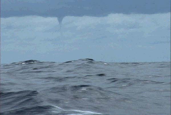
Here is a pix of one getting ready to drop in for a visit!

water spout

Source NOAA

WATERSPOUTS THREAT TO SHIPPING ?

In the summer of 1949, a message was broadcast describing an exotic natural phenomenon. On a coastal region of New Zealand, a rain shower was accompanied by the fall of thousands of small-sized fish. A similar occurrence was observed in 1933 by the inhabitants of village of Kavalerovo in Primor'ye Territory, but instead of fish, there was a rain of jellyfish.

In August, 1972, a giant waterspout appeared near the town of Khosta (Black Sea coast). Darkness covered the town. On the coast of Tikhaya Bay, a waterspout dropped a huge mass of water (about 150,000 tons).

In historical chronicles, there are many authentic stories about similar kinds of unusual rains. The cause of these rains is often waterspouts, the diameter of which range from several tens of meters up to 3 km, with an average height of 800 - 1,500 m, and on occasion, 2 - 3 km. The wind-speed inside a waterspout reaches 100 m/s. The vortices move with a speed of 5 - 10 m/s and sometimes, up to 30 m/s. The duration of the “life” of waterspouts is from several minutes to several hours. During this time, they can travel hundreds kilometres, destroying everything in their paths.

For a long time, the nature of waterspouts remained a riddle. It has now been found that waterspouts occur when air masses spin rapidly during thunder-storms in areas where the air-flow has a sharply distinguished speed of movement, temperature and water vapour content.

When a storm-cloud passes, there are sharp changes in the wind direction and speed and also differences in the air temperature in the most intense section. Unevenly heated air masses have different densities and collisions occur, causing a spinning motion. The rotation rate increases, and a waterspout is born. When air rotates in a vortex, centrifugal forces are generated. The air pressure inside the tube of a waterspout is sharply reduced, and the difference between this pressure and the outer edge may be as much as 200 mbar. Because of this air-pressure difference, there is almost no cooling taking place, resulting in condensation of the water vapour always present inside of the tube.

A waterspout has a cloudy tube descending to the sea-surface. The sharp decrease in air-pressure inside the tube of a waterspout also explains why suction occurs when one is present. For this reason, as soon as the tube of a waterspout breaks contact with the sea-surface, all of the water being carried is dumped, falling to earth. A waterspout is capable of lifting and carrying particles of sand, water, stones, live sea creatures, and sometimes, people, roofs of houses, etc. All of these can be carried long distances. Waterspouts often cause some destruction at coastal beaches, frequently killing people. If a vessel at sea encounters a waterspout, it is a dangerous situation. Source: UN Atlas of the Oceans

(Jesse Ferrell) of The WeatherMatrix Blog. Has a excellent post with pix's on the End-of-Year Waterspouts for Florida.

NWS Key West Florida has a good page for spout pix's...

NWS Gaylord Michigan has a excellent write up on spouts in the Great Lakes

Storm Chaser Steve Sponsler sent me these videos of a spout taking a whack at some ships at anchorage on May 26, 2007.


SISTERS! JUNE 11, 2007


SISTERS NOT GOOD ENOUGH? MARCH 30, 2007


LASTLY MARITIME NOTES:

January 24, 2008
Ships Collide in Newark Bay and Fluid Leaks
WNBC 4HD NYC

Shortly before 2 this afternoon, three ships collided in Newark Bay, closing the bay to marine traffic.

The three-way collision was between two dredging vessels, the 117-foot Melvin Lemmerhirt and the New York, and the 669-Foot Liberian tanker Orange Sun. The Orange Sun is reported to be carrying orange juice as its cargo. Reports also say the New York is taking on water, that there is a fluid leaking from one of the ships (presumably, not orange juice), and there's hydraulic fluid leaving a sheen on the waters nearby. The juice-filled Orange Sun is being brought back to harbor via tugboat.

Newark Bay is about six miles long and one mile wide and is a tidal back bay of New York Harbor. It's bound by the shores of Newark and Elizabeth on the west, Jersey City on the east and Staten Island on its south. Port Newark-Elizabeth, which is in Newark Bay, is the main port of entry for the New York area.

Ice Prince Update Ice Prince Update

Latest information on the Greek-registered cargo vessel that sank last week.


MSC Napoli: A Year Late
Nearly a year after the MSC Napoli first ran into trouble, the first phase of removing its stern has been completed.

JANUARY 24, 2008 CALIFORNIA SPOUT/TORNADO UPDATE

A rare tornado has touched down in Southern California. It started as a waterspout last night (24 JANUARY) in the Pacific and came ashore at the Point Mugu (muh-GOO') Naval Air Station up the coast from Malibu, ripping a roof off a hangar. It scattered debris on a tarmac but nobody was hurt and flight operations were not affected. The small tornado was from a much bigger storm system that's been causing problems in Southern California, pounding the region with heavy rain and deep snow and triggering at least two tornado warnings last night. Hundreds of cars and tractor trailers had been left stranded on a major highway north of Los Angeles. One driver says he was stuck on the road for 24 hours.


Chicago Weather? Clear, with a low around -1. Wind chill values as low as -12. West wind between 5 and 10 mph.


Forget cold.... Cold was in November....
This will be a good weekend to stay home and do some honey do's......like dusting!

Have a great....brrrrr ...warm weekend!


RS
PS: Thanks Steve....

Thursday, January 24, 2008

The Oceans Have Their Own Weather Systems

Pioneering expeditions investigate how eddies make life bloom in oceanic deserts

In the 87 days that Dennis McGillicuddy and colleagues spent in the Sargasso Sea in the summer of 2005, they were tossed around or chased by four hurricanes and two tropical storms: Franklin, Harvey, Irene, Maria, Nate, and Ophelia.

Not one of those massive storms was as powerful as the one swirling in the water beneath them.

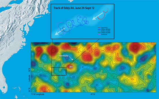
From June to September, McGillicuddy and a team of more than 20 scientists from Woods Hole Oceanographic Institution and five other marine science labs tracked an eddy named A4. It was the oceanic equivalent of a hurricane—a huge mass of water spinning like a whirlpool, moving through the ocean for months, stretching across more than 62 miles (100 kilometers), stirring up a vortex of water and material from the depths to the surface.

“Eddies are the internal weather of the sea,” says McGillicuddy, an associate scientist in the WHOI Applied Ocean Physics and Engineering Department. But unlike destructive hurricanes, eddies can be productive. As certain types of eddies stir the ocean, they draw nutrients up from the deep, fertilizing the waters to create blooms of microscopic marine plants in the open ocean, where little life was once thought to exist.

“The open ocean is twice as productive as we can explain based on what we know about nutrients in the water,” said McGillicuddy. “Where do all the nutrients come from to make these oases in the oceanic desert?”

Pump up the volume (of nutrients)
The Sargasso Sea—south and east of the Gulf Stream—forms the geographic center of the North Atlantic Ocean. It is warmer, saltier, bluer, and clearer than most other parts of the North Atlantic, except for the floating mats of
sargassum seaweed that gave the sea its name. For centuries, prevailing wisdom was that such open ocean waters were mostly desert-like, unproductive regions.

A lecture on the Sargasso Sea in the early 1990s sparked McGillicuddy’s curiosity. In the talk, Bill Jenkins, a senior scientist in the WHOI Marine Chemistry and Geochemistry Department, pointed out that scientists were finding more oxygen being produced and consumed in the open ocean than anyone expected. The suspects were phytoplankton, microscopic marine plants that produce oxygen in photosynthesis, and zooplankton (microscopic animals) and bacteria, which use oxygen as they consume plants and organic detritus that sink to the seafloor.

Scientists found 10 times more microscopic life in the Sargasso Sea than anyone could explain, given the dearth of nitrate, phosphate, trace metals, and other nutrients that plants need to grow in sunlit surface waters. Researchers slowly developed the hypothesis that vortices of cold or warm water—eddies—might somehow act as a biological pump.

“I had proposed a problem, and Dennis suggested a solution,” Jenkins said. “He had the clever idea that eddies were perturbing the layers of the water column, mixing different waters, and bringing nutrients up from below.” The upwelling of nutrients into the euphotic zone (the top 330 feet or 100 meters of the ocean, where light penetrates) would stimulate prodigious blooms of phytoplankton, which attract zooplankton and other animals up the food chain.

The Eddies Dynamics, Mixing, Export, and Species composition (EDDIES) project was born.

Into the eye of the oceanic storm
“Dennis has wanted to do this experiment since he was a graduate student,” said Dave Siegel, a longtime collaborator with McGillicuddy and an oceanographer from the University of California, Santa Barbara (UCSB).

McGillicuddy mustered chemists, biologists, and physical oceanographers from WHOI, UCSB, Rutgers University, Bermuda Biological Station for Research (BBSR), Virginia Institute of Marine Sciences, Dalhousie University, and the University of Miami. Together, they secured $3.5 million from the National Science Foundation, as well as five months of ship time over two years on the WHOI-operated research vessel
Oceanus and the BBSR-operated Weatherbird II.

The goal: to make detailed chemical, biological, and oceanographic measurements of a specific eddy by getting right into the middle of it.

“We didn’t want to just sit on the fence and watch from one point,” said Ken Buesseler, chairman of the WHOI Department of Marine Chemistry and Geochemistry. “Eddies move and develop, so we decided to follow a parcel of ocean as it moved. This was the first time anyone has really studied an eddy in this way.”

Toward a holistic view of scientific problems
Eddies are distinct parcels of water that move and jostle within the ocean, much like warm and cold air masses or high- and low-pressure systems in the atmosphere. Eddies are formed by differences in ocean temperature and salinity that give water different densities. Like oil and water, water masses of different densities tend to keep separate, rather than mix.

The largest eddies can contain up to 1,200 cubic miles (5,000 cubic kilometers) of water and can last for months to a year. Earth’s rotation—the Coriolis force—gives eddies their spin.

To hunt for their target, McGillicuddy and colleagues used data from satellites, whose measurements of sea surface heights show telltale signs of eddies. Warm-water eddies form bumps in the ocean; cold-water eddies form depressions. The team examined several eddies and settled on anticyclone No. 4, or A4, a “mode water” eddy (see "The Hunt for 18° Water") that stretched some 93 miles (150 kilometers) in diameter at the surface.

The EDDIES program took a truly integrated approach, combining many tools—satellites, ships, moorings, drifters, robotic vehicles, computer models—and many types of scientists.

From June 20 to Sept. 14, 2005, the researchers zigzagged across the eddy as it drifted southwest about 3.7 miles (6 kilometers) per day. The team on
Oceanus buzzed around collecting water and nutrient samples, measuring current speeds and directions, and towing WHOI biologist Cabell Davis’ Video Plankton Recorder through the turbulent swirl. Bill Jenkins and his lab mates measured natural chemical markers such as tritium, an indicator of the amount of plant-fueling nitrate being raised from the depths. WHOI Senior Scientist Jim Ledwell, an expert on using tracers in the ocean, injected sulfur hexafluoride, a harmless chemical, into the middle of the eddy and tracked how it spread up, down, and across the sea.

At the same time, a research team on
Weatherbird II made targeted measurements in the core of the eddy, measuring plant and animal productivity, the movement of particles, and thorium, a radioisotope that marks how much organic material is sinking from surface waters. Siegel used a radiometer to measure whether the eddy was disturbing the light penetrating the blue water.

“Ocean scientists are moving toward a more holistic view of their research problems,” said Siegel. “Ocean science grows by filling in the cracks between disciplines. If you put a smart and diverse group of people together in a boat, a lot of good things can happen. People start to think outside of their own little research worlds, and together we can tell scientific stories that we couldn’t put together individually.”

Stirring up a rich soup

Fueled by nutrients from the deep, diatoms bloomed to concentrations 10,000 to 100,000 times the norm—among the highest ever observed in the Sargasso Sea.

At the same time, the team was surprised to find historically low concentrations of oxygen in the depths, a sign of zooplankton and bacterial population explosions. It also meant that an awful lot of heat-trapping carbon dioxide may have been drawn out of the atmosphere and ocean surface, transformed by phytoplankton, and sunk to the bottom of the ocean.

Six months after the last EDDIES researcher stepped off
Oceanus, the scientists are still assessing and analyzing the wealth of data they collected on A4. The team met in February 2006 at the international Ocean Sciences Meeting in Hawaii to share observations and collectively make sense of what they saw. Ultimately, the goal is to develop high-resolution computer models—McGillicuddy’s specialty—that can simulate and predict the full range of eddy dynamics.

The EDDIES project is a critical step toward comprehending these great ocean storms, whose sheer size and scale are daunting. During the expedition, tropical storm Harvey made a direct hit in early August, cutting a path right across eddy A4. The eddy hardly felt Harvey; the monstrous atmospheric storm never came come close to breaking up the potent, voluminous swirl of water in the ocean.


Mike Carlowicz


The EDDIES project received funding from the Chemical Oceanography, Biological Oceanography, and Physical Oceanography branches of the National Science Foundation.


WEATHER STORY

One of the severe weather issues that face the Great Lakes Region is severe Ice Jam flooding. So what are Ice Jam Floods? As NWS (LOT) Chicago explains....

Ice Jam Flooding

Wilmington ice jam 2007
Kankakee River Ice Jam at I-55 Feb 2007

Ice jams are resulting in flooding on some rivers in northern Illinois. The National Weather Service advises that if you come upon a flooded roadway, turn around, don’t drown! Also, do not attempt to drive around barricades placed at flooded roads. It only takes as little as 2 feet of flowing water to float many vehicles. More than half of all flood-related fatalities are a result of individuals attempting to drive through a flooded roadway.

What is an ice jam?
An ice jam is a stationary accumulation of ice that restricts flow. Ice jams can cause considerable increases in upstream water levels, while at the same time downstream water levels may drop, exposing water intakes for power plants or municipal water supplies. Types of ice jams include freezeup jams, made primarily of frazil ice; breakup jams, made primarily of fragmented ice pieces; and combinations of both.

Why are we experiencing so much ice jam flooding at this time?
Earlier this month, northern Illinois experienced warm temperatures that melted the existing snow in combination with heavy rainfall that resulted in near record flooding on some streams. Although water levels have receded since the near record levels, they remain well above normal for this time of year. These higher than normal flows are resulting in more substantial flooding when an ice jam forms.

Can you predict ice jams?
The National Weather Service monitors river levels at select gages on area streams, maintained and operated by the U.S. Geological Survey
. However, ice jams can be very localized and the gage reading may not always reflect what is happening a few miles upstream or downstream from the gage. In addition, jams can form and break with little or no warning making ice jams very difficult to predict.

If you live along streams prone to ice jams you should continue to closely monitor river levels and listen for possible flood statements or warnings. When a jam forms, water can rise many feet in minutes versus hours and days in a normal river flood, and you may have little time to take action. Report ice jams and ice jam flooding to local authorities for relay to the National Weather Service.


MARITIME NOTES

m/v Kapitan Uskov disappeared in East China sea - 1/24/2008 02:41
January 24, 01.15 LT – message from Germes Co., Sovgavan port (vessel’s operator) – dry cargo Kapitan Uskov disappeared in approximately 31.40N 125.58E area, East China sea, last communication was at 03.00 January 20, didn’t arrive at port of destination ETA January 24. All vessels in area requested to keep a sharp lookout and assist if possible. Japan S&R sendind a plane, Shanghai S&R also informed, asked to assist.m/v Kapitan Uskov (ex-Fine) IMO 8203830, dwt 5223, built 1982 Japan, flag Cambodia, owner ALAZARA NAVIGATION S.A, cargo 4523 rolled steel, crew 17 – all russian citizen.Weather 2-meters sea, wind NNE 20 knots.

NOAA – new Director of Office of Response and Restoration

The National Oceanic and Atmospheric Administration (NOAA) issued a news release stating that Mr. David Westerholm has been appointed as the new Director of the Office of Response and Restoration. (1/22/08).


READERS COMMENTS - CAPTAIN DUNSEL
Believe it or not I do sometimes get comments to my blog. Most are complimentary and many times informative and some even corrective. Then again I also get comments posted anonymously or without return emails and even possibly with stage names. I love these the most. They are always critical. Most of the times I just chuckle and hit the delete button since I view these as "coward postings". If one is going to bother to post to any ones blog or story at least have the common decency for the blogger or author to return a answer. But I guess its just human nature to be a "Captain Dunsel" once and a while...

Moreover if I make a mistake and its pointed out I normally thank the commenter and post the correction after the mistake has been vetted, (IF) the commenter has done so constructively. But in Mr. Paul Williams case (if that is his or hers real name) this "Captain Dunsel" posting deserves a reply on my blog.

Mr. Paul Williams writes,

"Paul Williams has left a new comment on your post The M/V Aratere Incident"

The video fottage attached to this story is of one of the Strait Shipping vessels, NOT an Interislander vessel and certainly NOT the Aratere. If you're going to post these sorts of messages and attach video footage then at least get it right. The interislander vessels are consideralbly larger than the Strait Shipping vessels, so this video is very misleading."

Mr. or Mrs. Williams here is referring to my
posting of Tuesday, August 28, 2007 on The M/V Aratere Incident and my posting of Friday, June 8, 2007 Another Plane Of View. Where I posted a picture of the M/V Aratere instead of one of Strait Bluebridge Ferry Service Passenger Ferries the Suilven. Well Mr. Paul (Captain Dunsel) Williams, many of us once and a while do make the wrong ship identifications. We all make mistakes. And after reviewing the video (fottage) footage I did in fact ID the vessel as Straits Suilven. You were correct. You get a cookie for this.

But lets talk about the rest of Captain Dunsel's posting and ship particulars here while missing the entire point. Captain Dunsel says "
The interislander vessels are "consideralbly" larger than the Strait Shipping vessels". The Suilvan came out of service in 2003. So we can only gauge Straits (Santa Regina or the Monte Stello) against the Aratere. The M/V Aratere's length is 150m or 492ft, has a beam of 20.25m or 66ft and its Gross Tonnage is 12,300. The Santa Regina has a length of 137m or 449ft with a beam of 22.5m or 73ft with a Gross Tonnage of 14,588. The Monte Stello has a Length of 126.5m or 415ft with a beam of 21m or 68ft and with a Gross Tonnage of 11,630.

The difference between the ships? Aratere Vs. The Santa Regina? Length 43 ft and a beam difference of 25 ft to Aratere's favor. While the Santa Regina is heavier by 2200 Gross Tons. The Aratere Vs. The Monte Stello? Difference in length? 77ft and a beam difference of 68ft. Length favors Aratere and the beam favors the Monte Stello and not the Aratere, while the tonnage difference is only 670 Gross Tons.

Well Captain Dunsel in the terms of ship particulars of this class of vessel your definition of "
consideralbly larger" is slightly off base like your spelling and really a false flag. These ships are very close in general arrangements. While I should have spent more time in identification, which I take full responsibility for. Though I was not the only one to make this mistake it seems.

Moreover the size difference between these vessels really does not make that big of a difference nor is it misleading in any sense as Captain Dunsel notes. The wave actions vs. the ships maneuverability tells the real story, so does the crews and passengers. And that was the point!! It did not make a difference that day, any one of these ships would have encountered almost the same problems. Though the Aratere nearly capsized...

Thank You Captain Dunsel for your posting. I have made the corrections. Next time please have the courtesy to email me directly or send me a posting with both your email addy and your constructive criticisms....

RS