 Hurricanes - The World's Most Destructive Weather
Observing hurricanes is not just a dry academic exercise - what do you do if they head your way?
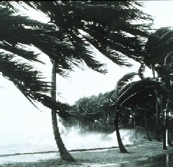
There is no doubt that hurricanes are right at the top of anyone's severe and extreme weather list.
With winds in excess of 175mph (280kph) and storm surges over 20ft (6m), damage can be complete and widespread.
Without adequate warning, loss of life can also be high, due to both drowning and injury.
Occurrence and Formation
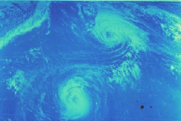
Hurricanes are examples of cyclones - a term for any zone of low pressure enclosed within an area of higher pressure, in which the system rotates anticlockwise in the northern hemisphere, and clockwise in the south. Once the sustained wind speed exceeds 74mph (120kph) the system is defined as a hurricane in the Atlantic and eastern Pacific Oceans, a typhoon in the northwestern Pacific, and a tropical cyclone, severe tropical cyclone, or severe cyclonic storm in the southwestern Pacific or Indian Ocean.
An excellent source of information on hurricanes can be found at the National Hurricane Center website. In particular, check out the FAQ section.
Hurricanes occur in most parts of the tropics wherever the ocean waters can heat up to 80°F or 26.5°C but not within about 300 miles (500km) of the equator. They regularly occur in seven areas.
- Atlantic Basin - North Atlantic Ocean, Caribbean Sea, Gulf of Mexico
- Northeast Pacific Ocean - west of Mexico
- Northwest Pacific Ocean - from about the dateline to Asia, including the South China Sea
- North Indian Ocean - Bay of Bengal and Arabian Sea
- Southwest Indian Ocean - east of Africa
- Southeast Indian Ocean - west of Australia
- Southwest Pacific Ocean - east of Australia
Apart from warm oceans, other requirements for their formation include
- Moist air extending well into the troposphere
- Instability in the atmosphere, allowing thunderstorms to form
- A pre-existing near surface disturbance with some rotational component
- and not too much wind shear, or variation in wind speed and direction with height.
Hurricanes usually start as a tropical depression and intensify to become a tropical storm. With further growth, they evolve into a well organised, rotating system with strong sustained winds and heavy rain.
Once wind speed has reached 74mph (120kph), they've earnt the name hurricane.
Hurricane Categories
Because hurricanes vary so much in size and intensity, it has become necessary to categorize them to give some indication of the danger they pose to communities in their path. So while size, internal pressure, and wind speed are all important, other factors such as storm surge are very relevant.
The Saffir-Simpson Hurricane Scale, used in the USA and adjacent areas, is a 1-5 rating based on the hurricane's present intensity. This is used to give an estimate of the potential property damage and flooding expected along the coast from a hurricane landfall. While the hurricane is in open waters, wind speed is the most important factor.
Wind speed is a major contributor towards damage, and also controls the other major cause of destruction, storm surge. However storm surge varies a lot depending on the depth of the sea, the shape of the coast, and the position of the center of the hurricane. As a general rule, storm surge will be greatest to the left of the eye as it nears and crosses the coast, viewing the hurricane from the shoreline. Local disaster coordinators will be able to assess the type of damage likely in their areas.
It is important to keep in mind that hurricane intensities can change quickly. It is always better to be on the safe side, particularly if evacuation is necessary. On the other hand, things may not turn out as bad as they seemed. Both Hurricanes Katrina and Rita from late 2005, devastating as they were, decayed from Category 5 storms to Category 3 by the time they crossed the coast. But while wind speeds were not as severe as they might have been, storm surges generated during their most severe stages remained very high.
Much of the section on the Saffir-Simpson scale has been taken with little alteration from the NOAA page covering classification. I don't like ripping off other sources, but in this case it sppears best to include the full text here.
Category One Hurricane: Winds 74-95 mph (119-153 km/hr). Storm surge generally 4-5 ft (1.2-1.5m above normal. No real damage to building structures. Damage primarily to unanchored mobile homes, shrubbery, and trees. Some damage to poorly constructed signs. Also, some coastal road flooding and minor pier damage. Hurricane Lili of 2002 made landfall on the Louisiana coast as a Category One hurricane. Hurricane Gaston of 2004 was a Category One hurricane that made landfall along the central South Carolina coast.
Category Two Hurricane: Winds 96-110 mph (154-177 km/hr). Storm surge generally 6-8 feet (1.8-2.4m) above normal. Some roofing material, door, and window damage to buildings. Considerable damage to shrubbery and trees with some trees blown down. Considerable damage to mobile homes, poorly constructed signs, and piers. Coastal and low-lying escape routes flood 2-4 hours before arrival of the hurricane center. Small craft in unprotected anchorages break moorings. Hurricane Frances of 2004 made landfall over the southern end of Hutchinson Island, Florida as a Category Two hurricane. Hurricane Isabel of 2003 made landfall near Drum Inlet on the Outer Banks of North Carolina as a Category 2 hurricane.
Category Three Hurricane: Winds 111-130 mph (178-209 km/hr). Storm surge generally 9-12 ft (2.7-3.7m) above normal. Some structural damage to small residences and utility buildings with a minor amount of curtainwall failures. Damage to shrubbery and trees with foliage blown off trees and large trees blown down. Mobile homes and poorly constructed signs are destroyed. Low-lying escape routes are cut by rising water 3-5 hours before arrival of the center of the hurricane. Flooding near the coast destroys smaller structures with larger structures damaged by battering from floating debris. Terrain continuously lower than 5 ft above mean sea level may be flooded inland 8 miles (13 km) or more. Evacuation of low-lying residences with several blocks of the shoreline may be required. Hurricanes Jeanne and Ivan of 2004 were Category Three hurricanes when they made landfall in Florida and in Alabama, respectively.
Category Four Hurricane: Winds 131-155 mph (210-249 km/hr). Storm surge generally 13-18 ft (4-5.5m) above normal. More extensive curtainwall failures with some complete roof structure failures on small residences. Shrubs, trees, and all signs are blown down. Complete destruction of mobile homes. Extensive damage to doors and windows. Low-lying escape routes may be cut by rising water 3-5 hours before arrival of the center of the hurricane. Major damage to lower floors of structures near the shore. Terrain lower than 10 ft above sea level may be flooded requiring massive evacuation of residential areas as far inland as 6 miles (10 km). Hurricane Charley of 2004, a Category Four hurricane, made landfall in Charlotte County, Florida with winds of 150 mph. Hurricane Dennis of 2005 struck the island of Cuba as a Category Four hurricane.
Category Five Hurricane: Winds greater than 155 mph (249 km/hr). Storm surge generally greater than 18 ft (5.5m) above normal. Complete roof failure on many residences and industrial buildings. Some complete building failures with small utility buildings blown over or away. All shrubs, trees, and signs blown down. Complete destruction of mobile homes. Severe and extensive window and door damage. Low-lying escape routes are cut by rising water 3-5 hours before arrival of the center of the hurricane. Major damage to lower floors of all structures located less than 15 ft above sea level and within 500 yards of the shoreline. Massive evacuation of residential areas on low ground within 5-10 miles (8-16 km) of the shoreline may be required. Only 3 Category Five Hurricanes have made landfall in the United States since records began: The Labor Day Hurricane of 1935, Hurricane Camille (1969), and Hurricane Andrew in August, 1992. The 1935 Labor Day Hurricane struck the Florida Keys. Hurricane Camille struck the Mississippi Gulf Coast causing a 25-foot (7.6m) storm surge, which inundated Pass Christian. Hurricane Andrew of 1992 made landfall over southern Miami-Dade County, Florida causing 26.5 billion dollars in losses--the costliest hurricane on record. In addition, Hurricane Gilbert of 1988, plus Hurricanes Katrina, Rita and Wilma were all Category Five hurricanes at peak intensity.
Evacuation of residential areas near the shore is likely with Category 3 Hurricanes, and mandatory for Category 4 and 5. But if you are worried, don't wait for the official word.
Other areas affected by hurricanes, typhoons or cyclones use similar intensity scales.
Naming Hurricanes
Hurricanes and their equivalents in other parts of the world are given names for several reasons. Firstly, a simple naming system makes the warning process much more effective. Secondly there may be more than one active hurricane in an area, and individual names allows better reporting of their positions and threats.
Names are also given to tropical storms in the North American region, although not elsewhere in the world. This is sensible, as tropical storms can evolve into hurricanes, degenerate back to storms, and even reform to hurricane grade. Regardless of their classification they are a single weather event, and need to be watched until their final decay.
New names are assigned at the beginning of each hurricane season and dealt out in alphabetical order as each storm or hurricane appears. Names may be reused, but names of notable destructive hurricanes (Andrew, Camille, Gilbert, for example) are withdrawn.
The letters Q, U, X, Y, and Z are not used (not very many names start with these letters, giving an annual reserve of 21 names. In most years, thankfully, this is more than enough, but in the record year 2005 it wasn't. Plan B was to use the Greek alphabet, so Alpha, Beta, Gamma, Delta and Epsilon were used late in the season. Even Zeta got the nod for a late storm right at the end of 2005, well after the official end of the hurricane season.
OK, take a break before going on to Part 2 - Hurricane Tracking & Recording . Or, for something a bit lighter, try Part 3 - Tracking Hurricane Rita . Nothing too heavy there - just a few notes on what I was able to see using available resources (links are included on the page) as Rita exploded from Category 1 to Category 5 before calming to Category 3 before crossing the Gulf Coast on the Texas - Louisiana border.
More information on Hurricanes can be found among the Severe Weather articles, while you'll find heaps of other great resources -DVDs, videos, books, posters etc - at More Hurricane Resources
Ever wondered what it's like to stay on as a hurricane passes overhead? Check out Hurricane Safety for an account of sitting through Hurricane Wilma as it struck Southern Florida in October 2005.
MARITIME NOTES
Survival gear may have saved fishermen
March 26, 2008 | By Amy Remeikis
The pilot involved in a dramatic sea rescue off Moreton Island says safety features on the boat of the stranded fishermen may have made the difference between life and death.
The four Brisbane men were spearfishing about five nautical miles off Cape Moreton on Monday afternoon when what they described as a freak wave swamped their boat, causing it to overturn and leaving the men stranded in turbulent water.
The men had no time to send out a distress signal and could only cling to the side of the vessel and hope help came.
It did – in the form of the Energex community rescue helicopter, which was activated by Australian Search and Rescue in Canberra about 2.30pm.

The Energex helicopter was involved in a dramatic sea rescue after a fishing boat was hit by a “freak” wave off Moreton Island
The AUSSAR satellite and aircraft flying overhead had picked up the distress signal from the vessel’s Emergency Position Indicating Radio Beacon.
Energex pilot Wayne Thompson said the vessel’s EPIRB and the other safety features the men had equipped it with may have made the difference between life and death.
“They had all the survival equipment, they had the EPIRB which is an absolute must, they had flares which they used to help guide us to them. They were quite well prepared,” he said.
“It could have been the difference between life and death for sure. They were blips in the ocean. It could have been a whole different outcome for them.”
With his crew helping Mr Thompson to position the aircraft, Dan King was winched down to the men where he helped them into the rescue strop.
The men were taken one by one to a nearby exposed reef and once all four were out of the water, they were airlifted two at a time to the Cape Moreton helipad.
One man was taken to Princess Alexandria hospital with a back injury.
“They said it was a huge sense of relief when they realised the helicopter was there for them,” Mr Thompson said.
“It was one of the more difficult rescues we have done, but it was a great result.”
Riverdance ferry will be scrappedThe owners of the Riverdance ferry have admitted the vessel will be scrapped after it is eventually removed from the Fylde coast.
Efforts are still ongoing to refloat the ferry, but Seatruck Ferries Ltd, have declared that the Riverdance will never sail again A spokesman for Seatruck said: "She has been declared a constructive loss and will not return to service.
"She suffered very significant damage during the last bout of bad weather.
"The plan is still to remove her in one piece, but she will be scrapped after that."
A meeting between the salvage team, the boat's owners and their insurance company was scheduled for last week, but that was postponed, and an announcement on the vessel's future remains more than a week away.
A spokesman for the Maritime and Coastguard Agency (MCGA) said: "Hugh Shaw, the Secretary of State's Representative for Maritime Salvage and Intervention, is currently looking at all options available, and is talking them through with the salvors and insurance company.
"We are still hopeful that the boat will be refloated in some form."
The ferry ran aground south of Cleveleys on January 31 after being hit by a freak wave during a storm.
Thousands of people have visited the area to see the stricken ferry, including over the Easter holiday.
Tuesday, 25 March 2008
Eighteen Ukrainian sailors are feared dead after a tug capsized and sank in Hong Kong after a collision with a cargo vessel. Salvors are working to attempt entry into the sunken ship, from which there have been no sounds or other indications of survivors amongst the crew trapped in the hull.
The Neftegaz 67 sank in 35 metres of water off Lantau Island on Saturday. Its hatches and deck are reportedly embedded in the sea floor, making rescue efforts difficult. The captain, who was among the seven crew rescued after the collision, has blamed the cargo vessel, the Yao Hai, for the incident, claiming it had not given his ship right of way.
The tug had been detained in Hong Kong in 2003 after port state control found its escape equipment and exits were deficient and that ship personnel did not know safety drills. It had not been detained since, however.
If the missing crew are confirmed dead, it would be Hong Kong’s worst maritime accident in decades.
RS


![[Valid RSS]](valid-rss.png "Validate my RSS feed")